


Introduction
Kelameili range is located in the northeast margin of Junggar Basin at the transition position between Alaty and Tianshan orogenic belts. It is a natural experimental site for studying the formation and evolution of Junggar Basin[1,2,3,4,5,6,7]. For the tectonic and sedimentary environment in the eastern Junngar Basin, a series of studies have been carried out, but there are still many controversies. For example, there are two opinions on whether orogeny continued after the closure of the Kelameili ocean: One viewpoint is believed that the Kelameili ocean was closed at the early Early Carboniferous[3]. Instead of immediate orogeny, a residual basin was formed between the two continental blocks, and the Nanmingshui Formation developed in the late Early Carboniferous, covering above the ophiolite unconformably[8,9]. The other opinion is that compressional collision occurred after the closure of the ocean, resulting in the uplift and orogeny of the Kelameili area and the formation of the Piedmont foreland basin[10,11,12,13]. Because the Kelameili area has experienced many structural superimposition and transformation, the structural characteristics are very complex[14,15,16]. Besides, the Carboniferous volcanic rocks are developed, and the quality of deep seismic data is generally poor, which leads to a great controversy about the geological structure of the Kelameili range and Dajing depression.
Based on the systematic survey of the Kelameili outcrop, previous studies believed that there were a large number of northward dipping thrust faults in the south of Kelameili fault zone, and two stages of strike slip thrust activities occurred in the middle of Late Carboniferous and middle Permian respectively[17,18]. Based on interpretation of the seismic section in front of the Kelameili range, it was concluded that large-scale thrust structures developed in the Kelameili fault zone and its south side, and controlled by the Kelameili deep fault, a foreland basin was formed in Dajing area in the Late Carboniferous[10, 12, 19-20]. Some scholars believe that the current structure is mainly controlled by the southward tectonic wedge[21]. For the “basin”-“range” relationship, previous studies showed that the Hercynian was a mainly strong coupling stage, and the Mesozoic to early Cenozoic was a weak coupling and adjustment stage[6]. However, the specific process of “basin” and “range” relationship evolution and the characteristics of Carboniferous basins in the study area are still need to be further studied.
Overall, the research level of the study area is relatively low. In recent years, the Xinjiang oil field of PetroChina has drilled many deep exploration wells in eastern Junggar Basin and deployed many high-resolution 2D seismic lines, which can clearly show inner structures and deformation characteristics of the Carboniferous. Besides, there are some contradictions between the new data and the previous Carboniferous stratigraphic framework. Therefore, we used a new Carboniferous division scheme to analyze the newly collected seismic sections, and got some new understandings on the geological structure and “basin” and “range” relationship of the study area. In addition, the Carboniferous is an important exploration layer in the northeastern Junggar Basin. In recent years, it has also shown great potential of oil and gas exploration. Therefore, the study of the deep geological structure of the Carboniferous in the Dajing depression has great practical significance for the oil and gas exploration in this area.
In this paper, four newly acquired 2D seismic lines in the study area are finely interpreted, and the structural geometry and kinematics analysis are carried out by using the fault- related fold theory. According to the axial analysis and the previous researches, the activity of different main faults and tectonic wedges in Kelameili range are analyzed. Using the balanced geological section technique, the formation-evolution process of the Kelameili range and Dajing depression are analyzed. Combined with the latest drilling and logging data, the tectonic-sedimentary frameworks of the Carboniferous in the eastern Junggar Basin are discussed.
1. Geological background
The Junggar Basin is located in the southern part of the Central Asian Orogenic Belt, and at the junction of the Kazakhstan, Siberian, and the Tarim plates (Fig. 1a). Kelameili range is located in the northeast margin of Junggar Basin (Fig. 1b), and is a Northwest trending linear orogenic belt[3]. It is about 220 km long and 20 to 50 km wide (Fig. 1c). Kelameili fault zone is the most important fault zone developed inside the orogenic belt[3]. Some researchers believe that this fault zone is a suture zone between the Kazakhstan and Siberian ancient plates, while some other researchers believe that the fault zone is a northward subduction zone of the ancient Siberian continental margin, rather than a suture zone between the two ancient plates[1, 3, 22]. Based on the understanding of the tectonic meaning of the fault zone, previous studies reconstructed the Paleozoic tectonic environment and evolution in the eastern Junggar Basin and even the entire Central Asia. From Middle-Devonian to early Early Carboniferous, the subduction of Kelameili oceanic plate to the northern Yemaquan arc resulted in the formation of the Kelameili orogenic belt[3] and the molasse formation of Lower Carboniferous Songkaersu Formation in Shuangjingzi area[11]. Zircon dating shows the overlying Carboniferous Batamayineishan Formation is volcanic rock of Early Carboniferous, which defines the orogenic timing of the Kelameili range[23]. During the Mid-Late Carboniferous, the eastern Junggar area was in a post-collision extension environment with strong volcanic activity, and collision orogeny happened again in the Late Carboniferous[24,25,26]. After the Carboniferous, the Junggar Basin mainly experienced tectonic movements in the Late Hercynian, Indosinian, Yanshanian, and Himalayan stages[7, 15, 27-28]. The multi-stage tectonic movements superimpose, giving rise to the complex structural features of the Kelameili area.
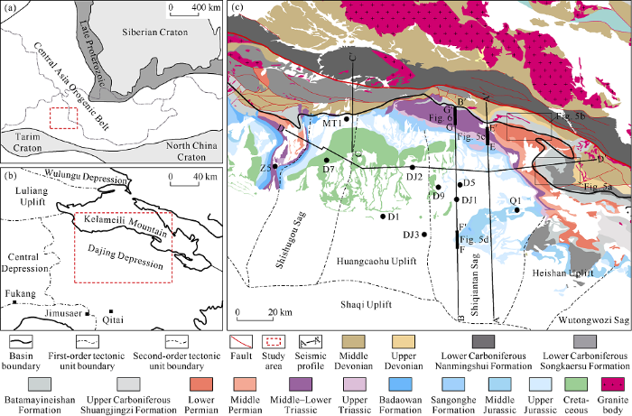
Fig. 1.
(a) Geotectonic location map of the Junggar Basin, (b) division of structural units in eastern Junggar Basin, (c) geological structure outline of the study area.
The study area of this work includes the Kelameili range and the Dajing depression. The Dajing depression includes the Shishugou sag, the Huangcaohu high, the Shiqiantan sag, the Heishan high and the Wutongwozi sag (Fig. 1c). The formations in Dajing depression are quite complete, including the pre-Carboniferous, Carboniferous, Permian, Triassic, Jurassic, Cretaceous, Lower Cretaceous, Neogene, Pliocene and Quaternary from the bottom to the top, while the Palaeogene and Pleistocene are missing (Figs. 1c and 2). In contrast, only Devonian and Carboniferous remain in the Kelameili range, the overlying strata are eroded[3].
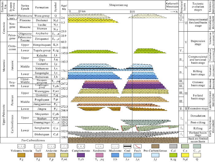
Fig. 2.
Tectonic movements, stratigraphic sequence and basin evolution of the study area (See
2. Division scheme and distribution of the Carboniferous in the eastern Junggar Basin
2.1. Division scheme of the Carboniferous in the eastern Junggar area
The stratigraphic division of the Carboniferous in the Junggar Basin is still in debate (Fig. 3), bringing about troubles to the study on Carboniferous. Therefore, it is necessary to make clear the relationships between the formations. According to the scheme of litho-stratigraphy in Xinjiang Uygur Autonomous Region, the Junggar Basin belongs to the northern Xinjiang stratigraphic region, and the study area corresponds to the Kelameili stratigraphic region and Jiangjunmiao stratigraphic region. In the 1:200000 geological mapping of Shuangjingzi area, the Xinjiang Bureau of Geology and Mineral Resources divided the Carboniferous in the south of Kelameili deep fault from the bottom to the top into: Lower Carboniferous Songkersu Formation, Middle Carboniferous
Batamayineishan Formation and Middle Carboniferous Shuangjingzi Formation (Fig. 4). The Songkersu Formation (named after the geological map) about 887 m overlies the upper Devonian unconformably. This formation is mainly composed of conglomerate and sandstone, mixed with siltstone and carbonaceous shale. It is a set of coarse clastic rock in the transition zone of marine and continent, with a large number of plant fossils. This formation was deposited in late Devonian or early Carboniferous. Batamayineishan Formation is established (named after the geological map) based on the Shuangjingzi outcrop (Figs. 1c and 5a). Here, in high-angle unconformable contact with the underlying Songkersu Formation, this formation is a set of volcanic rock and pyroclastic rock, mainly comprising olivine basalt porphyrite, basalt porphyrite, andesite porphyrite, felsite, rhyolite and tuff. It is attributed to the Middle Carboniferous on the geological map. Tan Jiayi et al.[23] dated a zircon sample from the volcanic rock at the top of Batamayineishan Formation in this area (named after the geological map), and the age was (350 ± 6.3) Ma, so it was concluded that the Batamayineishan Formation belonged to the lower Carboniferous. Li Di[29] dated a series of zircon samples from the volcanic rock of Batamayineishan Formation (named after the geological map) in this area, and the results showed the zircon samples aged from 351 to 335 Ma (Fig. 4), proving again that the volcanic rock of Bashan Formation belonged to the Lower Carboniferous. In recent years, many dating tests showed the Batamayineishan Formation in the Junggar Basin belonged to the Late Carboniferous, for example, (313.3 ± 4.7) Ma[30] in Well Ludong 1, (300.4 ± 1.3) Ma[31] in Well Sancan 1, and (306.8 ± 4.7) Ma in Well Shinan1[29], which indicates that the Batamayineishan Formation in the outcrop and in the basin are not the same set of stratum, and their connotations are also different. This is one of the main reasons causing the dispute on the stratigraphic division of Carboniferous.
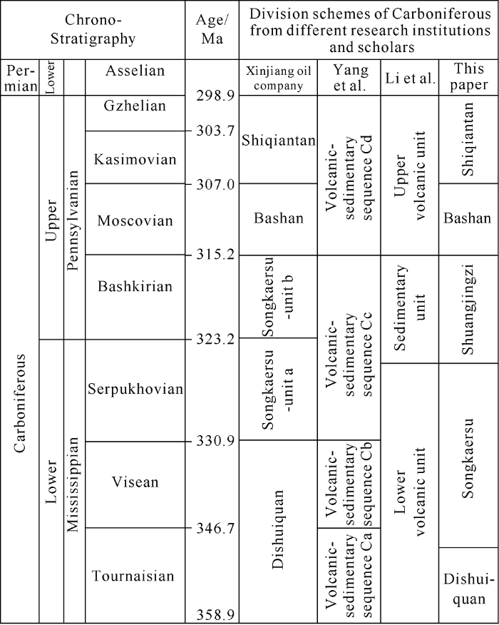
Fig. 3.
Comparison of different stratigraphic division schemes of Carboniferous in the Junggar Basin.

Fig. 4.
N-S well-tie profile from the Kelameili range to the Dajing depression (Age data sources from reference [29]).
In the Wucaiwan area of the Junggar Basin, Well Caishen 1 encountered a large set of dark mudstone and carbonaceous mudstone, which was named Dishuiquan Formation by the Xinjiang Oilfield company. Wang Shufang et al.[11] argued that the fine-grained sediment of the Dishuiquan Formation named by the Xinjiang Oilfield company and the coarse clastic sediment of the Songkaersu Formation (named in the geological map) in the Shuangjingzi area were contemporaneous sediment of different lithofacies in different positions of the forland system in the front of Kelameili range depositing in early Carboniferous; near the orogenic belt is coarse clastic rock, and the rock gradually turns finer towards the basin. We agree with this viewpoint. But this unit was given two names, likely to cause confusion.
In order to unify the nomenclature of the strata and their meanings, this work takes the latest stratigraphic division of the Carboniferous in the study area proposed by Li Di based on the latest drilling and seismic profiles of the Junggar Basin, combining outcrops, paleontological data, and latest chrono-logical data, in which the Carboniferous is re-divided into 5 sets of structural layers: the Lower Carboniferous Dishuiquan Formation, the Lower Carboniferous the Songkaersu Formation, the Shuangjingzi Formation, the Upper Carboniferous Batamayineishan Formation and the Shiqiantan Formation (Fig. 2).
2.2. Well correlation
The Dishuiquan Formation is the first set of sedimentary layer in the Junggar Basin, which is in angular unconformity with the underlying Devonian. Widely distributed in the study area, with sedimentary center at Shuangjingzi area, this formation thins towards the Dajing depression to the South and thickens towards the Wucaiwan sag to the northwest. It is a set
The Songkaersu Formation is characterized by fault depression, with multiple sedimentary centers. The D1 and DJ1 wells in the Dajing depression are the fault depression centers, and this formation thins towards Well MT1 to the north. The Shuangjingzi area may also be the center of the fault depression, where the Songkaersu Formation (named Batamayineishan Formation on the geological map) is up to 4 123 m thick. Lithologically, this stratum is mainly composed of medium-basic, acidic volcanic rocks, volcanic clastic rocks from multiple eruptions, and a small amount of clastic rock (Fig. 4). According to the two sets of large-scale sandy conglomerate, the Songkaersu Formation can be roughly divided into three large volcanic eruption cycles[23, 29].
The Shuangjingzi Formation was depression sediment after the rifting. It was wide in distribution range originally, but suffered large-scale erosion due to late tectonic activities (Fig. 4). But in the hinterland of Junggar Basin, such as the Luliang Uplift and the Wucaiwan Sag, the Shuangjingzi Formation is better preserved[32]. The Shuangjingzi Formation is mainly composed of sandstone, carbonaceous shale and some shallow marine biogenic limestone, and is a set of shallow marine sediment, in which the paleontological fossils were commonly seen in the Middle-Late Carboniferous. Due to strong tectonic activities at the end of Carboniferous, most of the Batamayineishan Formation and Shiqiantan Formation in the study area were denuded, and the Upper Carboniferous is left only in local parts.
3. Geological structure of the Kelameili range and the Dajing depression
3.1. Unconformities
Unconformity is the direct evidence of tectonic activity. Each unconformity can be regarded as the result of regional or local tectonic movement[33]. Based on the analysis of the seismic profiles of the Dajing depression and the outcrops of the Kelameili range, there are 10 sets of obvious unconformities in the study area, including the bottoms of the Dishuiquan Formation, Songkaersu Formation, Shuangjingzi Formation, Jingou Formation, Pingdiquan Formation, Lower Triassic, Xishanyao Formation, Lower Cretaceous, Upper Pliocene and Pleistocene (Fig. 2).
This study focuses on the unconformities of the Carboniferous and Permian. The Dishuiquan Formation has nearly east-west folds, and severely twisted, forming sharp folds in various directions. These folds are cut by the overlying Songkaersu Formation, forming a zigzag erosion surface (Fig. 5a). The unconformity between the Songkaersu Formation and the overlying Shuangjingzi Formation is smaller in angle, and is basically parallel with the stratum, which is also consistent with the rift and post-rift relationship of them (Fig. 5a).

Fig. 5.
Unconformity characteristics of the Kelameili range and the Dajing depression (Locations of the study area and profiles are shown in
The Shuangjingzi Formation is truncated by the overlying Lower Permian at a high angle, indicating that a large-scale tectonic movement happened before the Early Permian (Fig. 5b). On the seismic profile, it can be seen that the Jingou Formation and Jiangjunmiao Formation are truncated by the overlying Pingdiquan Formation at a high angle, with clear truncation points (Fig. 5c and 5d). Truncation features can also be recognized at the bottom of Lower Triassic and Middle Jurassic. Due to the strong tectonic activity in the late period, the Cenozoic strata were denuded, and the unconformity characteristics of the Lower Cretaceous, Upper Pliocene, and Pleistocene bottoms are all obtained from the geological map (Fig. 1c).
3.2. Seismic section interpretation
Based on the logging data of more than 10 wells in the study area, synthetic seismograms were made to calibrate the geological horizon of the seismic sections. Three N-S and one E-W seismic sections were interpreted by horizon tracking and closure and shallow geological constrains (Fig. 1c). Through the axial surface analysis of the seismic section, multiple dip zones were identified in the Carboniferous near the Kelameili range (Fig. 6), indicating that there are multiple thrust faults underlying, which is not consistent with the thrust model interpreted previously. The overlying strata are obviously tilted close to the range, and the turning position corresponds to the axial of the underlying strata (Figs. 7-9). So geometrically, the features are more consistent with the characteristics of structural wedge model. In addition, the pre-Carboniferous in the study area was in marine sedimentary environment, when a large set of marine clastic rock deposited, which provided the material basis for the development of thrust wedge. Therefore, in this work, we chose the tectonic wedge model for interpretation, and referred to the previous interpretation scheme of the western part of the Kelameili range[21].

Fig. 6.
(a) Original seismic section, (b) interpretated section and (c) geological structure section of the equal dip zone in the front of the Kelameili range (Location of the profile is shown in

Fig. 7.
(a) Interpretated section and (b) geological structure section of AA° (Location of the profile is shown in
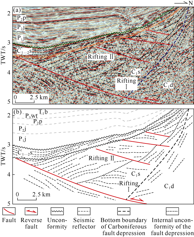
Fig. 8.
The multi-phase fault depressions in the Lower Carboniferous of the Dajing depression (Location of the profile is shown in

Fig. 9.
(a) Interpretated section BB′, (b) interpreted section DD′, and (c) interpreted section CC′ (Location of the profile is shown in
The AA° profile (Fig. 7) covers the southern part of the Kelameili fault zone and the Shiqiantan sag. The profile shows angular unconformities at the bottoms of the Jurassic, Triassic, and Pingdiquan Formation. The Carboniferous strata and above are thicker in the north of the Shiqiantan Sag and thin towards the south. In the northern Shiqiantan sag, the Early Carboniferous fault depression can be identified in the Songkaersu Formation. By tracing the reflections in the fault depression in detail, two phases of fault depressions can be identified. The first episode of fault depression is smaller and the second one is bigger in range (Fig. 8). The F1 boundary fault dips northward, and together with multiple secondary faults forms a half graben structure extending to the south end of the Kelameili thrust belt. The boundary faults of the Early Carboniferous fault depression terminate at the bottom of the Shuangjingzi Formation. The overlying Shuangjingzi Formation covers the fault depression of the Songkaersu Formation, with a wider distribution, showing the characteristics of depression (Fig. 8). Through axial surface analysis, at least 8 dip zones were identified in the pre-Carboniferous below the fault depression. Geometric analysis shows that at least two stages of structural wedges developed here (Figs. 6 and 7). The pop-in of the structural wedge southward led to the inclination of overlying strata southward, and the closer to the range, the greater the amplitude of the inclination. The turning position of the overlying strata defines the extension range of the structural wedge in the basin and the location of the wedge end point (Fig. 7). From the intersection between the two-stage tectonic wedges and fault depression and changes of stratum dip angle, it can be seen that the tectonic wedges developed after the fault depression, and the Early Carboniferous fault depression was also tilted to a certain extent. Besides, the second tectonic wedge was formed later than the first wedge, and exhibits post-expanded tectonic deformation features. Since the seismic section does not cover the Kelameili range in the north, this study mainly constrained it by shallow geology. Fig. 7 shows that mainly Devonian and Carboniferous expose in the north. These strata have formed steep closed steep folds, some of which have even inverted, and have multiple breakthrough thrust faults developed. Previous studies also showed that the Kelameili fault (Fk) is characterized by left strike slip and thrust[34], and a number of thrust faults developed on both sides of this fault, forming imbricate structure. In the south of the Shiqiantan Sag, the Carboniferous and its overlying strata form fault propagation folds, and the F2 fault goes down to the pre-Carboniferous basement detachment layer.
The BB° profile (Fig. 9a), parallel to the AA° profile, shows similar structural deformation characteristics. Early Carboniferous fault depression can be seen in the Songkaersu Formation, but the dip angle of the F1 fault is steeper and the scale of the fault depression is larger than that in the AA° profile. The F1 fault cuts through the overlying Shuangjingzi Formation, and the strata on the hanging wall of the fault slightly uplift, showing the characteristics of “snakehead” anticline, indicating that the fault has reversed at the end Carboniferous. According to axial surface analysis, two structural wedges were also recognized in the basin-range transition zone. However, as the second structural wedge gets in less, the most part of the piedmont monoclinic zone is smaller in inclination angle than that in the AA° section, and only turns steep sharply at the end of the second structural wedge. Due to strong activity of the Kelameili fault zone (Fk) after Carboniferous, the back wing of the structural wedge is also broken through by a series of thrust faults. In the south of Shiqiantan sag, the fault propagation fold formed by F2 fault is larger in amplitude than that in AA°. The F2 fault and the secondary F3 and F4 faults constitute fault propagation folds. Overall, the tectonic compression activity on the BB° section is stronger than that on the AA° section.
The CC° profile (Fig. 9c) crossing the south section of Kelameili fault zone and Shishugou sag shows the geological structure characteristics of the western section of Kelameili range. The activity of the Kelameili orogenic belt is obviously more intense on this section, and three tectonic wedges have developed beneath the Permian. The structural wedge ① and ② caused erosion of the Lower Permian and Upper Carboniferous, and the Jiangjunmiao Formation directly contacts with the underlying Carboniferous. In the basin-range transition zone, the Middle Permian to Upper Triassic were reversed and faulted, and the analysis suggests that the paleostructure may be the first stage of fault propagation in the Late Triassic-Early Jurassic. The activity of the late tectonic wedge ③ caused the Middle-Upper Permian and Mesozoic to tilt southward, and the Late Triassic paleostructure was also reformed. The back wing of the tectonic wedge was breached by the Kelameili fault, and the Devonian and Carboniferous were thrust to the surface, forming a series of tight, high and steep fault propagation folds.
DD° profile (Fig. 9b) is a crossline running through the Heishan high, Shiqiantan sag, Huangcaohu high, Shishugou sag and Shazhang fault and fold belt. This profile shows that affected by the basement fault possibly, the Carboniferous and the pre-Carboniferous raise from west to east. The front and back wings of the anticline are located in the east slope of Shishugou sag and the west slope of Shiqiantan sag respectively. At the intersection with the BB° section, the DD° section shows both the top and bottom faults of the first stage structural wedge, while at the intersection with the AA° section, it only shows the bottom fault of the first stage structural wedge. In east Heishan high and east of the Shazhang fault and fold belt, a series of fault propagation folds occur under the E-W compression since Triassic[15].
In conclusion, the above four seismic profiles reveal the complex multi-stage superimposed deformation characteristics of the Kelameili range and the Dajing depression. In the Early Carboniferous, the Dajing depression developed a north dipping Carboniferous fault depression, which was characterized by many episodes. The scale of the fault depression was larger in the west and smaller in the east. The Early Carboniferous fault depression structure was transformed by several structural wedges developed in the pre-Carboniferous, which showed that the structural deformation in the west was stronger than in the east. However, the transformation process of the structural wedge to the early fault depression and the “basin and range” coupling process still need to be further analyzed.
4. Tectonic evolution
Based on the balanced section of the N-S section (AA°) (Fig. 10), the evolution in the study area is divided into 10 stages, namely, the early Early Carboniferous, the middle-late Early Carboniferous, the turn of Early and Late Carboniferous, the early Permian, the Middle-Late Permian, the Triassic, the Jurassic, the Late Cretaceous and from the Paleogene on (Fig. 2).

Fig. 10.
N-S trending structural evolution profile (AA’) of Kelameili range and Dajing depression (Location of the profile is shown in
In the early stage of Early Carboniferous, the study area was in the stage of compressional foreland basin. It can be observed on the seismic section of Baijiahai uplift that this set of structural layer was obviously folded and partially truncated by the high angle overlying layer[35]. On the Shuangjingzi outcrop, it can be observed that the Dishuiquan Formation is a set of coarse clastic sedimentary assemblage dominated by sandy conglomerate, and gradually turns into fine clastic sediment towards the basin-ward depression (Figs. 2 and 4). In addition, the Dishuiquan Formation is wide in distribution range and large in scale.
In the middle and late Early Carboniferous, the basin was in a regional extensional environment, and multiple arcs have been identified in this area[29]. During this period, arc related fault basin developed in this area. This period witnessed massive extension of about 13.1 km. A series of half grabens were formed in Dajing depression, and a large amount of volcanic rocks and pyroclastic rocks were developed in the half graben.
Between the Early Carboniferous and the Late Carboniferous, the basin entered the stage of depression, during which tectonic compression movement also took place, causing the Shuangjingzi Formation partially eroded in the north and completely denuded in the south. By comparing with the center of the Junggar Basin, it can be seen that there was also a fault depression developed in the Late Carboniferous[32], but the tectonic compression movement at the end of the Carboniferous made the Carboniferous fault depression invert positively in general[15]. Since the Upper Carboniferous in the study area has been basically denuded, this period of fault depression is not discussed in this paper.
In the early Permian, the basin was in extensional environment again, with a large amount of volcanic rock developing in the west slope and the Zhongguai high of Mahu depression[15]. At the end of Early Permian, the Shuangjingzi Formation, Batamayineishan Formation and lower Permian were uplifted and eroded under regional compression. Although the overall shortening was small, only about 0.9 km, this tectonic compression movement made Kelameili range and Dajing depression couple strongly (Fig. 10).
During the Middle-Late Permian, the Jiangjunmiao Formation expanded to a wider range and gradually overlapped to the southern uplift. At the end of Jiangjunmiao period, due to regional compression, the first stage structural wedge of Kelameili range wedged southward, the Carboniferous fault depression in the Piedmont was tilted and transformed, and the middle and lower Permian near the range side was tilted and denuded as a whole. The shortening of strata overlying the structural wedge was 0.6 km. Since the tectonic wedge activity in the west was more intense, the Carboniferous fault depression in the west has been reformed to a higher degree, and the reverse characteristic of the fault depression is more significant. After that, the basin entered the depositional stage of the foreland depression, when Pingdiquan Formation and Wutonggou Formation deposited.
In the Triassic, the basin was still in a compressional environment. Small-scale unconformities can be found at the base of the lower Triassic in the uplift (Figs. 2 and 5d). A set of alluvial fan sedimentary system developed at the bottom of the Triassic, and the basin was further expanded during the Middle- Late Triassic, forming a unified large depression lake basin[15].
In the Jurassic, the basin basically inherited the pattern in Triassic, but was larger in sedimentary area, becoming a large shallow water basin[34]. At the end of the Xishanyao period, under the influence of compression and torsion of the basin margin, a series of secondary uplifts were formed in Shiqiantan sag. The faults in Shazhang area and Heishan high were reactivated, forming a west-to-east thrust fault, and a series of northeast-oriented anticline structures such as Shaqiuhe, Huoshaoshan, Zhangpenggou anticlines came up in the east part of the study area[34].
In the Late Cretaceous, the second tectonic wedge began active, causing the Paleozoic-Mesozoic in the piedmont to be lifted and eroded again. The formation shortening in this period was about 1.9 km.
In the Paleogene, the Kelameili range was strongly active again, breaking through the back wing of the early structural wedge, forming a series of NW-trending thrust faults [21]. Estimated with the fold vector of the outcrop, the structural shortening was about 18.1 km in this period.
From the above analysis, it can be seen that AA° profile 115.2 km long currently was 124.9 km long originally, with a total shortening of 9.7 km. Clearly, the study area has shortened, with a shortening rate of 7.8%. The compressional periods mainly include the early Early Carboniferous, Late Carboniferous, middle Late Permian, Late Cretaceous and Paleogene; while the extensional periods mainly include the middle-late Early Carboniferous, middle-late Late Carboniferous and Early Permian. From the evolution profile, the tectonic movement of Middle Permian made the Kelameili range and Dajing depression show a strong coupling relationship. However, the establishment and evolution process of “basin” and “range” relationship between the Kelameili range and the Dajing depression still need more comprehensive discussion.
5. Discussion
5.1. Coupling relationship between the Kelameili range and the Dajing depression
The formation of the basin and the thickness, composition and deformation of sedimentary materials in the basin are closely related to the orogeny around the basin. The geological structures formed during the migration of the basin-range system are also recorded in the sediments inside the basin[36,37]. For the study on “basin” and “range” coupling, it is not only necessary to examine the deformation and interaction of basin and related orogenic belt in time and space[38,39,40], but also to analyze the regional dynamic background and movement process[41,42,43,44].
Li Jinyi et al.[3] studied the outcrops on the south side of the Kelameili fault zone and concluded that the exposed Devonian Kalamaili Formation and Lower Carboniferous Tamugang Formation (corresponding to Dishuiquan Formation in this paper) are mainly a set of shallow marine terrigenous source clastic sediment, in which the clast of sandstone is mainly lithoclast with poor rounding and sorting, showing the characteristics of near-source sediment. Wang Shufang et al.[11] believed that the set of coarse clastic sedimentary assemblages developed in the Lower Carboniferous Songkaersu Formation in Shuangjingzi area was the product of foreland fold thrust belt, and turned into fine-grained clastic sediment towards the basin. On the 1:200000 geological map, it can be seen that the Dishuiquan Formation has been severely distorted, forming several sharp-edged folds in various directions. At the same time, it can be seen that the Lower Carboniferous is folded on the seismic section of Baijiahai uplift. These evidences show that the study area was probably in the stage of compressional foreland basin from Late Devonian to Early Carboniferous, when a compresso-flextural basin formed in the Jiangjunmiao area. The Kelameili ocean subducted northward since the Late Devonian and closed at Early Carboniferous, leading to the collision and welding of Junggar plate and Siberian plate[3, 45]. Therefore, based on the comprehensive analysis of many geological facts and regional dynamic background, it can be inferred that the “basin” and “range” relationship in the study area was first established in the late Devonian to the Early Carboniferous.
Due to the regional extension in the middle-late Early Carboniferous, a series of fault depressions were developed in Dajing depression. The Late Carboniferous and Early Permian were also in the stage of fault depression, during which the “basin” and “range” relationship experienced a certain degree of weakening.
In the Middle Permian, a structural wedge developed in the south side of the Kelameili range. The structural wedge moved southward, causing strong coupling between Kelameili range and Dajing depression and the Jiangjunmiao foreland basin system also migrated towards the basin. In Triassic, the basin inherited the features before. The unconformity between the Triassic and the Jurassic can be observed on the AA° profile, and the paleo-structure of the Middle Permian and the Upper Triassic reversely faulted can be seen on the CC° profile (Fig. 9C), corresponding to the Indosinian movement. Although the tectonic compression weakened on the whole, the “basin” and “range” relationship in the Middle Permian remained.
Since most of the strata above Jurassic on the seismic profile are denuded (Figs. 7-9), the time constrains of tectonic activity after Jurassic needs to be determined in combination with other analysis and methods. Li Li et al.[46] analyzed and compared apatite fission track of exposed granite bodies around the Kelameili range and Junggar Basin, and concluded that the Kelameili range experienced four stages of uplift and denudation, namely, Late Triassic to Early Jurassic (180-210 Ma), Middle-Late Cretaceous (95-115 Ma), Late Triassic to Early Jurassic (180-210 Ma) and Late Paleocene to Early Eocene (50-60 Ma). The tectonic movement in the Middle to Late Cretaceous is in good agreement with the result of previous studies[47,48,49], corresponding to the late Yanshanian movement. This period was the time when the second phase structural wedge developed and the “basin” and “range” relationship strengthened. The tectonic activity from late Paleocene to early Eocene corresponds to the thrust and nappe event in the northern margin of Junggar Basin in Paleogene[50]. During this period, the back wing of the tectonic wedge was broken through by a large number of thrust faults, forming a large number of tight folds; and the “basin” and “range” were in strong coupling relationship.
To sum up, since the Kalamaili ocean closed in the early Early Carboniferous, the “basin” and “range” relationship between Kelameili range and Dajing depression was established for the first time, and then experienced a certain degree of weakening from the middle- late Early Carboniferous to the early Permian, and strong coupling again in the Middle Permian. The following Indosinian, Yanshanian and Himalayan movements all inherited this “basin” and “range” relationship.
5.2. Tectonic-sedimentary framework of the Carboniferous in the eastern Junggar Basin
The main exploration objects of the Carboniferous in the study area are the source rock-reservoir-in-one type combinations. The distribution of oil and gas is controlled by the source rock, while the distribution of effective source rock is controlled by the Carboniferous tectonic-sedimentary framework. Therefore, it is of great significance for the exploration to study the Carbonifereous tectonic-sedimentary framework. On the basis of previous studies on the sedimentary environment of Carboniferous in the outcrop area, the residual distribution of Carboniferous fault depressions and depression was delineated by tracing a large number of seismic lines, and the structural sedimentary frameworks in different periods of Carboniferous in the eastern Junggar Basin were discussed in this study.
In the early stage of Late Paleozoic, the Kelameili area gradually broke up into arc belts from early continental marginal basin. The back-arc basin developed into Kalamaili limited ocean basin, with Lower Devonian ophiolite generally exposed[3, 51]. From the Devonian, the Kelameili ocean subducted towards the Yemaquan island arc terrane in the north, forming a large amount of arc volcanic rock[52,53], which eventually led to the closure of the Kelameili ocean in the early Early Carboniferous[45]. Consequently, the Kelameili volcanic arc was accreted to the southern margin of the Siberian continental plate[3]. In the background of regional compression, a foreland basin was formed in the Jiangjunmiao area south of Yemaquan arc[54]. In the early Early Carboniferous, the provenance came from Kelameili range in the north. Thick layer of coarse clastic molasse formation was developed in the piedmont zone, and the clastic material became thinner to the south (Fig. 11a). The Dishuiquan Formation is the first set of Carboniferous source rocks, which is better in the south of Dajing depression than in the north. Based on previous analysis, the kerogen of the source rock is type Ⅱ2-Ⅲ, with high maturity[55], which could be an effective source rock. Because the source rocks are buried very deep in the basin, they are only drilled in Wucaiwan and Baijiahai area.

Fig. 11.
Tectonic-sedimentary frameworks of the Carboniferous in the eastern Junggar Basin in different periods (Modified from reference [56]).
From the middle to the late Early Carboniferous, the tectonic stress in the study area changed from compressional to extensional. Consequently, the early thrust faults had “negative reversal”, forming a series of NW-trending fault depressions along the suture zone (Fig. 11b). In the Shuangjingzi area, the Songkaersu Formation developed with a thickness of 4123 m, showing the characteristics of linear eruption. During this period, a large number of volcanic activities occurred, and the half graben was filled with volcanic rock and pyroclastic rock erupted in multiple periods. This period corresponded to the two episodes of fault depression identified on the seismic profile (Fig. 8). By tracking a large number of seismic profiles, at least three NW- and NWW-fault depressions have been identified in the basin, with sedimentary centers located in wellarea DJ1, the south of wellarea D1 and wellarea T3 respectively. The volcanic rocks of the eruption and overflow facies were reformed by dissolution along unconformities in multiple periods, forming high-quality reservoir with good storage capacity and permeability, which constitutes the Lower Carboniferous source-reservoir combination with the underlying source rock of the Dishuiquan Formation.
Between the Early Carboniferous and the Late Carboniferous, the extension gradually weakened, and the area entered the stage of depression. In the piedmont region of Kelameili range, a continental clastic sedimentary system came up in an extensive range, namely the Shuangjingzi Formation. The Shuangjingzi formation cropping out in the Baijinggou outcrop has about 400m thick carbonaceous shale interbedded with coal seam, with a large number of Late Carboniferous plant fossils. This set of strata encountered in Well DJ1 and D5 of Dajing depression is composed of mainly sandstone, carbonaceous mudstone and other clastic rocks. It is the main effective Carboniferous source rock encountered in the basin, with high TOC and low to high maturity[55]. Combined with seismic interpretation, multiple sedimentary centers (hydrocarbon generation centers) have been identified, including areas of Well CS1, DJ1, south Jiangjunmiao and Well T1 (Fig. 11C). The provenance of the source rock might come from island arc terranes on the north and south.
During the middle-late Late Carboniferous, the basin experienced a rifting and post-rifting cycle, and this set of volcanic and clastic sedimentary rocks was completely preserved in the Luliang uplift[56,57]. In the late Late Carboniferous, the arcs in most parts of Junggar Basin have been consolidated into a unified terrane[56]. Under this background, the Kelameili range uplifted again, resulting in a large area of denudation of the Upper Carboniferous, only some preserved in the northern part of Dajing depression. In the eastern and central parts of the study area, the Upper Carboniferous was basically denuded (Fig. 11d). The residual Batamayineishan Formation and the underlying Shuangjingzi Formation constitute the upper Carboniferous source-reservoir combination.
6. Conclusions
According to the latest drilling and seismic data, combined with outcrop, paleontology and chronology analysis, the Carboniferous in the study area is divided into Dishuiquan Formation, Songkaersu Formation, Shuangjingzi Formation, Batamayineishan Formation and Shiqiantan Formation. The Songkaersu Formation in the Shuangjingzi outcrop (named in the geological map) and the Dishuiquan Formation inside the Junggar Basin (named by Xinjiang Oilfield company) are both the Dianshuiquan Formation, which is contemporaneous sediment of different lithofacies in different positions of the foreland basin depositing in early Early Carboniferous.
There are 10 obvious unconformities in the study area, namely the bottoms of the Dishuiquan Formation, Songkaersu Formation, Shuangjingzi Formation, Jingou Formation, Pingdiquan Formation, lower Triassic, Xishanyao Formation, lower Cretaceous, Pliocene and Pleistocene. Through seismic interpretation, it is revealed that the Carboniferous in the basin develops fault depression structure. The Songkaersu formation is characterized by multi-episode rifting, and the Shuangjingzi formation is characterized by post-rifting. In the Piedmont, a number of complex structural wedges developed in the pre-Carboniferous and the wedging time was mainly in the Middle Permian and late Cretaceous. The structural wedges caused the Carboniferous fault depression and basin-range transition zone to tilt and suffer reformation. From the late Paleocene to the early Eocene, the back wings of the structural wedges were broken through by a series of thrust faults, forming a series of complex fault propagation folds and anticlines.
The coupling between the Kelameili range and Dajing depression was first established in the early Early Carboniferous. Due to regional extension, it weakened to some extent in the middle-late Early Carboniferous and Early Permian, but strengthened again in the Middle Permian. Later Indosinian, Yanshanian and Himalayan movements inherited this relationship.
In the early Early Carboniferous, the Kelameili ocean was closed in the study area, forming a foreland basin. The Dishuiquan Formation is the first set of source rock of Carboniferous. Arc related faulted basin developed in the middle and late Early Carboniferous in the study area. Due to dissolution along multi- stage unconformities, the volcanic rock of the Songkaersu Formation could be reformed into high-quality reservoir with good storage capacity and permeability. It constitutes the Lower Carboniferous source-reservoir combination with the Dishuiquan source rock. Between the Early and Late Carboniferous, the extension weakened and the study area became a depression basin, and the Shuangjingzi Formation deposited extensively, which is the main source rock of the Carboniferous. At the end of Carboniferous, the study area uplifted and suffered massive erosion, and part of the Upper Carboniferous has been left in the piedmont depression only. The Upper Carboniferous and the underlying Shuangjingzi Formation make up the Upper Carboniferous reservoir-source combination.
Reference
The deep-shallow structures and oil-gas distribution in Junggar Basin
Main characteristics of late Paleozoic plate tectonics in the southern part of east Junggar, Xinjiang
Palaeozoic accretionary and convergent tectonics of the southern Altaids: Implications for the growth of Central Asia
Evolution of the Altaid tectonic collage and Paleozoic crustal growth in Eurasia
Bain-range coupling and segmentation of the Junggar Basin
On structures and evolutions in Junggar Basin
The intercontinental residual basin of the Karamay orogenic belt in the eastern Junggar Basin, Xinjiang
Late Devonian-Early Carboniferous radiolarian fossils from siliceous rocks of the Kelameili ophiolite, Xinjiang
Tectonic evolution of the foreland basin at northeastern margin of Junggar and its relationship with oil-gas
Petroleum geological characteristics of gas accumulation in Carboniferous volcanic and prospects for gas exploration, eastern Junggar Basin
Evolution of Junggar late Carboniferous-Permian foreland basin
Structures of the eastern Junggar Basin: Intracontinental transition between the North Tianshan and the Altai Orogens
Tectonic evolution stages and features of the Junngar Basin
Formation and evolution of multicycle superimposed basins in Junggar Basin
Geological features of the Karamaili faulting belt, eastern Junggar region, Xinjiang, China and its constraints on the reconstruction of Late Paleozoic ocean-continental framework of the Central Asian region
Formation and evolution of the Kalamaili fault zone
Further researches on the tectonic evolution and dynamic setting of the Junggar Basin
Structural features of foreland thrust belt and petroleum accumulation at the north-eastern margin of Junggar Basin, China
Basin-range coupling model of the southern margin of the weastern part of the Karamaili mountains
Types and time of Carboniferous volcanic edifices in eastern Junggar, Xinjiang
Geochemical characteristics and tectonic setting of Carboniferous volcanic rocks from Ludong-Wucaiwan area, Junggar Basin
Geochemistry and tectonic settings of Carboniferous intermediate-basic volcanic rocks in Ludong-Wucaiwan, Junggar Basin
Genesis of early Carboniferous volcanic rocks of the Di’nan Uplift in Junggar Basin: Constraints to the closure time of Kalamaili ocean
The formation and evolution of Chepaizi-Mosuowan paleo-uplift and its control on the distributions of sedimentary facies in the Junggar Basin
Characteristics of tectonic deformation within transitional belt between the Junggar Basin and the northern Tianshan Mountain
Carboniferous tectonic framework and sedimentary filling evolution in the Junggar Basin and adjacent area, NW China
Tectono-stratigraphic evolution of the Carboniferous arc-related basin in the East Junggar Basin, northwest China: Insights into its link with the subduction process
Zircon U-Pb and Hf isotopes of volcanic rocks from the Batamayineishan Formation in the eastern Junggar Basin
Characteristics of seismic wave groups and tectono-stratigraphic sequences of the Carboniferous, eastern Luliang Uplift, Junggar Basin
Structure of unconformity and its control on hydrocarbon accumulation
Structural evolution and hydrocarbon accumulation in the eastern Junggar Basin
Geological structure and genesis model of the Baijiahai Uplift in the Junggar Basin
Foreland basin and its definition and research
Coupling and mass exchanging in foreland-thrust systems
Geodynamics of sedimentary basins: The main trend of basin research
Orogeny and coupled decoupled basin developing: Application in petroliferous basin analyses
Coupling relationships of sedimentary basin-orogenic belt systems and their dynamic models in west China: A case study of the Longmenshan orogenic belt-west Sichuan foreland basin system
Orogeny and coupled decoupled basin development: A review
Petroleum geology controlled by extensive detachment thinning of continental margin crust: A case study of Baiyun Sag in the deep-water area of northern South China Sea
The pre-Sinian rift in central Sichuan Basin and its control on hydrocarbon accumulation in the overlying strata
Apatite fission track evidence for uplifting-exhumation processes of mountains surrounding the Junggar Basin
Mesozoic-Cenozoic uplift of the Tianshan intraplate orogenic belt: Evidence from zircon and apatite fission track dating
Fission- track evidence for the exhumation history of Bogda-Harlik mountains, Xinjiang since the Cretaceous
The Mesozoic and Cenozoic exhumation history of Tianshan and comparative studies to the Junggar and Altai mountains
Compressional and thrust structures of the early Paleogene and their coupling sedimentary processes in the northern Junggar Basin of Xinjiang
Main characteristics and emplacement processes of the east Junggar ophiolites, Xinjiang, China
A Devonian to Carboniferous intra-oceanic subduction system in Western Junggar, NW China
Carboniferous mantle-derived felsic intrusion in the Chinese Altai, NW China: Implications for geodynamic change of the accretionary orogenic belt
Early Carboniferous collision of the Kalamaili orogenic belt, North Xinjiang, and its implications: Evidence from molasse deposits
Carboniferous source rocks in the Ludong-Wucaiwan area, Junggar Basin, NW China
Tectonic framework of the northern Junggar Basin part I: The eastern Luliang Uplift and its link with the east Junggar terrane
Tectonic framework of the northern Junggar Basin part II: The island arc basin system of the western Luliang Uplift and its link with the west Junggar terrane
