PETROLEUM EXPLORATION AND DEVELOPMENT, 2020, 47(3): 513-526 doi: 10.1016/S1876-3804(20)60069-6
RESEARCH PAPER
Sedimentary environment and petrological features of organic-rich fine sediments in shallow water overlapping deposits: A case study of Cambrian Yuertus Formation in northwestern Tarim Basin, NW China
JIN Zhimin1,2, TAN Xiucheng,1,2,*, TANG Hao1,2, SHEN Anjiang2, QIAO Zhanfeng2, ZHENG Jianfeng2, LI Fei1,2, ZHANG Shixuan1, CHEN Lei1, ZHOU Chenggang3
State Key Laboratory of Oil and Gas Reservoir Geology and Exploitation, Southwest Petroleum University, Chengdu 610500, China
Key Laboratory of Carbonate Reservoir, CNPC, Hangzhou 310023, China
Korla Branch of Geophysical Research Institute, BGP Inc., Korla 841000, China
China National Science and Technology Major Project. 2016ZX05004002-001 National Natural Science Foundation of China. 41602147
Abstract
Taking the Cambrian Yuertus Formation outcrop profiles in the Aksu-Keping-Wushi areas of northwestern Tarim Basin as examples, the depositional environments of organic rich fine sediment were analyzed by examining the outcrop profiles macroscopically and microscopically. The study reveals that: (1) The lower part of the Yuertus Formation consists of organic-rich fine sediment or thin rhythmic interbeds of organic-rich fine sediment and siliceous sediment, the formation transforms to terrigenous diamictic grain shoal and inverse grading carbonate rocks upward. (2) The thin limestone interbedded with dark shale rhythmically has inverse grading. (3) The thin-bedded siliceous rock has metasomatic residual granular texture, stromatolithic structure and cementation fabric in vugs. (4) There are iron crust layers at the top of the shallowing diamictic grain shoal, beneath which exposed karst signs, such as karrens, dissolved fissures, sack-like vugs, near surface karst (plastic) breccia, breccia inside the karst system and terrigenous clastic fillings, can be seen. (5) Both the outcrops and seismic profiles show that organic-rich fine sediments above the unconformities or exposed surfaces are characterized by overlapping. The organic-rich fine sediment of the Cambrian Yuertus Formation was deposited in the anoxic-suboxidized restricted gulf lagoon environment, and its formation was controlled by high paleoproductivity and poor oxygen exchange jointly, then a shallow-water overlapping sedimentary model has been established. The results will help enrich and improve the sedimentary theory of organic-rich fine sediments.
Keywords:fine-grained sediments
;
source rock
;
shallow water overlap
;
exposed surface
;
paleokarst
;
sedimentary model
;
Cambrian Yuertus Formation
;
Tarim Basin
JIN Zhimin, TAN Xiucheng, TANG Hao, SHEN Anjiang, QIAO Zhanfeng, ZHENG Jianfeng, LI Fei, ZHANG Shixuan, CHEN Lei, ZHOU Chenggang. Sedimentary environment and petrological features of organic-rich fine sediments in shallow water overlapping deposits: A case study of Cambrian Yuertus Formation in northwestern Tarim Basin, NW China. [J], 2020, 47(3): 513-526 doi:10.1016/S1876-3804(20)60069-6
Introduction
Organic-rich fine-grained sedimentary rocks not only act as important hydrocarbon source rocks, but also provide storage space for shale oil and gas resources[1,2]. In recent years, as fine-grained sedimentary rocks become a major domain for increasing reserves and production, study on this kind of rock has become a hot spot[3,4,5]. However, there is still huge controversy over the sedimentary environment and mode of organic-rich fine-grained sedimentary rocks, which hinders the prediction of this kind of rock and exploration and exploitation of unconventional oil and gas resources in them.
Fine-grained sedimentary rocks generally include shale, mudstone, and claystone[6], which are traditionally described as homogeneous, unstructured, in massive and/or stratified rock units, and finer than 62 μm in grain size generally. Their mineralogical components are mainly clay, silty sand, carbonate, and organic matter[4]. Specifically, fine-grained sedimentary rocks with bedding are generally referred to as shale, while those without bedding, argillaceous rocks[7]. These fine- grained sedimentary rocks are conventionally speculated to be deposited through suspended sedimentation in deep-water basin environment with quiet water body and permanent hypoxia[8, 9]. But, some recent research indicates some of the rock may be of shallow-water origin[10,11,12]. In general, most clay particles finer than 10 μm tend to flocculate, and flocculation is conducive to long-distance transport of large quantity of muddy sediments in the marine environment[13,14]. In contrast, clay particles larger than 10 μm tend to settle down in the form of single particles[15,16]. Morphologically monotonous laminar or massive mudstones are deposited in turbulent environment, in the form of aggregate particles[3, 5, 11]. A series of sedimentary features including scour surfaces, reworked lag deposits, both normal and reverse grading of particles, hummocky cross-stratification consisting of currents, waves and ripples, and gray-green shale intercalations are observed in the shallow-water black shale[10, 17]. A recent study reports direct overlapping of the organic-rich Devonian Chattanooga shale over a major unconformity in the southern Appalachian Basin[18], which again supports the possibility that organic-rich fine-grained sedimentary rocks could be formed in relatively shallow-water environment with flowing currents and oxygen-bearing bottom water that supports benthic life.
As the largest petroliferous basin in China, the Tarim Basin has been in a heated debate on its main source rocks[19,20]. Specifically, the Lower Cambrian Yuertus Formation with wide distribution in the Aksu area is considered as an important set of source rock[21]. However, no consensus has been reached when it comes to the depositional environment of the Yuertus Formation in the Aksu-Wushi-Keping area. Most researchers proposed that the Yuertus Formation was deposited in deep-water shelf to deep basin environments based on analysis of petrology, geochemistry and organic matter type[22,23,24]. Some researchers believed it was deposited in middle-deep ramp environments based on limited drilling and seismic data[25]. A few researchers argued it was deposited in shallow-water environment through investigation into the sedimentary sequences and petrographic characteristics of siliceous rocks[26,27].
The latest study shows source rock as the fine-grained sedimentary rock richest in organic matter often occurs very next above an unconformity[18], which indicates possible overlapping of organic-rich fine-grained sedimentary rocks on the unconformities in a shallow-water environment during the early transgression. Recently, we observed typical overlapping of the Yuertus Formation on the regional unconformity at the top of the Sinian Qigebulak Formation in the northwestern Tarim Basin, which also suggests it may be deposited in shallow-water environment. It should be noted that deep-water environments in abovementioned research generally refer to undercompensated deep basin environment, middle-deep ramp environment, and deep-water continental shelf environment. In comparison, shallow-water environments refer to shallow-water (shallower than tens of meters) continental shelf environments with compensated to overcompensated sedimentation. In this study, taking the Yuertus Formation in the northwestern Tarim Basin as an example, the lithofacies, micropaleontological fossils, trace and constant elements, and seismic data of fine-grained sedimentary rocks on some profiles were investigated carefully to figure out its sedimentary environment and depositional model. Results of this study can not only provide strong sedimentological evidence for identifying the sedimentary environment of the Yuertus Formation black rock series in the northwestern Tarim Basin, but also enrich the sedimentological theory of fine-grained sedimentary rocks, so they are of great scientific and practical significance.
1. Regional geological background
As a large craton basin in the northwestern Xinjiang, China, the Tarim Basin, with an area of about 56×104 km2, is developed on a continental crustal basement composed of Archean and Early-Middle Proterozoic metamorphic rocks[28]. The study area geographically spans Aksu-Wushi-Keping counties, while it is tectonically in the Keping block uplift on the northwestern edge of the Tarim platform (Fig. 1). During Nanhua-Sinian periods, the Tarim plate was mainly located in the northwestern margin of the Eastern Gondwana supercontinent, in direct contact with the Australian plate. At that time, it was in the mid-low latitudes of the northern hemisphere[29, 30], but it started to drift southward, reaching the equator during the early Cambrian, and starting to detach from the Australian plate. By then, the entire plate periphery was in a strongly tensional rifting environment, accompanied by formation of extensive open sea at the continental margin of the northern Tarim and the intracontinental rift at the southern Tarim[30]. Within the Tarim plate, the water depth was deep in the east and shallow in the west. Correspondingly, there was a deep- water basin in the Korla-Ruoqiang-Qiemo area of the eastern Tarim and a shallow-water platform in the Kuqa-Minfeng- Aksu area of the western Tarim[31].
Fig. 1.
Geological setting of the study area in Tarim Basin and the Cambrian outline [35,36].
The Lower Cambrian Yuertus Formation is widely and stably distributed in the Tarim Basin. It lithologically consists of gray and black phosphorous siliceous rock, thin-layered dolomite, black carbonaceous shale, gray-green shale containing sandy dolomitic limestone, thin-layered gray-white microcrystalline dolomite, and nodular dolomite containing thin-layered yellow-green and purple-red shale from bottom to top (Fig. 2). Small shelly fossils, algae and Bradoriids are observed under the microscope[32]. The overlying Lower Cambrian Xiaoerbulake Formation[33] is mainly composed of trilobite-containing dolomite-limestone deposits, and is believed to be in conformable contact with the Yuertus Formation by some researchers. The underlying Upper Sinian Qigebulak Formation is in parallel unconformable contact with the Yuertus Formation and mainly consists of gray mudstone and algal dolomite[34]. A penecontemporaneous exposure surface is present, and it can be traced laterally for a long distance (Fig. 2). Organic-rich shales in the study area are thinly interbedded with either siliceous rocks or carbonate rocks (Fig. 2). Specifically, organic-rich shales interbedded with siliceous rocks mainly occur at the bottom of the Yuertus Formation, which can be traced laterally. In comparison, organic-rich shales. interbedded with carbonate rocks are mainly observed in the middle and upper parts of the Yuertus Formation, with lithofacies changes in some sections (Fig. 2).
Fig. 3.
Macroscopic and microscopic characteristics of thin organic-rich shale and siliceous rock interbeds. (a) Macroscopic photo of thin shale and siliceous rock interbeds, Shiairike section; (b) Micrograph of siliceous rock with metasomatic residual granular structure, plane-polarized light; (c) Counterpart of Fig. 3b under orthogonally polarized light (G: silicified particle structure, A: algal particles, C: siliceous cement); (d) Micrograph showing siliceous rock with metasomatic residual laminated structure, Shiairike section, plane-polarized light; (e) Counterpart of Fig. 3d under orthogonally polarized light (A: algae particles, C: siliceous cements and fillings in along-layer cavities, with generational features); (f) Sharp contact between black shale and gray-green shale, Sugaite section.
2.1.1. Lithofacies
The siliceous rocks come in thin layers and dark black. According to structural characteristics, two types of siliceous rocks are identified, siliceous rock with granular structure and that with residual stromatolithic structure. Siliceous particles are mainly phosphorous oncolite, organic algal spherulite, algal filaments, (micro) biological debris (such as small shelly fossils and filamentous cyanobacteria), and organic matter- clay composites[26] (Fig. 3b and 3c). These particles are moderately to well sorted and rounded, 0.1-0.5 mm in grain size. Coarse crystalline siliceous cements are observed filling between dissolved dolostone particles with original outlines (Fig. 3c). The siliceous rock with residual stromatolithic structure has alternate bright and dark horizontal laminae, along-bedding dissolution pores and vugs (Fig. 3d and 3e) filled with coarse-grained siliceous cements of generational features (Fig. 3e), and algae particles and silicified particles in scattered distribution.
Shales are mainly dark-gray to gray-black, occasionally gray-green (Fig. 3f). They are mainly composed of quartz, dolomite, apatite, and clay minerals, with some pyrite and iron nodules. Organic matter is commonly observed under the microscope, including massive amounts of benthic algae fragments, siliceous calcareous sponge spicules, and biological fragments[35,36,37,38]. According to a previous study on organic matter contents in shale samples from ten outcrop sections[39], the shale samples thinly interbedded with siliceous rock have higher contents of organic matter, with TOC of more than 2% in general, and up to 11.5% locally.
The diamictic grainstone comes in greyish-white to greyish-yellow and medium-thick layer, and has flat base and convex top macroscopically and uneven thickness laterally (Fig. 4a and 4b). Microscopically, within the diamictic grainstone interval, the lower part is mainly dolomitic fine sandstone, with a grain size range of 0.1-0.25 mm, a particle content of 60%-80%, and a dolomite content of about 20%-40%. The terrigenous detrital particles are mainly quartz, with a small amount of lithic fragments and feldspars (Fig. 4c and 4d). In the middle of the diamictic grainstone interval, with the decrease of terrigenous detrital debris content, sandy dolomite gradually takes the dominance (Fig. 4e and 4f). In the upper part of the diamictic grainstone interval, terrigenous detrital debris disappears, and crystal dolomite with residual granular structures becomes dominant (Fig. 4g). Observation of thin sections on a piece of 70 g A4 paper under microscope shows the original rock fabric features typical granular structure, clearly visible residual intergranular dissolved pores (Fig. 4h), and a general grain size range of 0.25-0.5 mm (Fig. 4h).
Fig. 4.
Macroscopic and microscopic characteristics of diamictic grainstone. (a) Thin shale and siliceous rock interbeds + terrigenous diamictic grainstone, Sugaite section; (b) Macroscopic photo of diamictic grainstone outcrop, showing a flat bottom and a convex top; (c, d) Dolomitic fine sandstone (Q: quartz, P: apatite, C: rock cuttings; Fig. 4c is under plane-polarized light, and Fig. 4d is under orthogonally-polarized light); (e. f) Sandy dolomite; Fig. 4e is under plane-polarized light, and Fig. 4f is under orthogonally-polarized light); (g, h) Residual granular phantom of the crystalline dolomite (Fig. 4h is the plane-polarized photomicrograph of thin section on a piece of 70g A4 paper); (i) Wave-built cross-bedding above the diamictic grainstone.
2.1.2. Sedimentary sequences and sedimentary structures
The sedimentary sequence is composed of interbedded thin organic-rich shale and siliceous rock layers and diamictic grainstone. Vertically, interbedded thin organic-rich shale and siliceous rock layers gradually transit into diamictic grainstone (Fig. 4a), and they are often in continuous and gradual contact. In general, the diamictic grainstone layer features reverse grading of particles and wave-built cross-bedding in its upper part (Fig. 4i).
2.2. Thinly interbedded shales and limestones
Another occurrence of shale is thin interbeds with limestone, as shown in Fig. 5a. This kind of shale is limited in distribution in the study area, and it changes in lithofacies in some sections (Fig. 2).
Fig. 5.
Thin shale and limestone interbeds. (a) Thin shale and limestone interbeds. The length of the yellow arrow reflects the shale thickness, Sugaite section; (b) Siderite nodules and limestone lens in shale; (c) Thin-layered limestone with typical reverse grading of particles; (d) -(f) micrographs showing granular limestone with decreasing grain size, plane-polarized light.
2.2.1. Lithofacies
The limestone comes in thin-very thin layers, greenish-gray, granular structure, with occasional dolomite, and gradual contact with black shale with even contact surface. The thick shale intervals often contain siderite nodules and limestone lenses (Fig. 5b), as well as pyrite and other authigenic minerals occasionally. In comparison, the shales are black and sometimes gray-green, composed of calcite, quartz and dolomite minerals, and have massive amounts of biological fragments and algae clearly seen under microscope[38]. The shale samples interbedded with limestone generally have a TOC range of 1.5%-4.5%[39].
2.2.2. Sedimentary sequence and sedimentary structure
This sequence is composed of thin shale and limestone interbeds. The shale layers vary greatly in thickness from 1 to 60 cm. Vertically, the shale layers become thinner gradually upward (Fig. 5a), while carbonate layers become thicker upward. Some thin limestone layers have reverse grading of particles clearly (Fig. 5c). Observed under the microscope, the limestone layers in the lower part have calcite grains finer than 0.1 mm (Fig. 5f), while calcite grains become coarser in the middle and upper parts (Fig. 5d and 5e), reach a maximum size of 0.25-1.5 mm at the layer top. These coarse-grained calcite monocrystals at the layer top were argued to be fragments of echinodermata[27].
2.3. Exposure characteristics of the upward-shallowing sequence
The upward-shallowing sequence of the Yuertus Formation in the study area is characterized by gradual lithologic change at the base and sudden lithologic change at the top. The lower part of the sequence is the relatively deep-water deposit of organic rich shale or thin interbeds of organic rich shale and siliceous rock, while the upper part is mainly diamictic grainstone. Due to the effect of vertical accretion, the diamictic grainstone grew rapidly upward, and finally stopped growing and exposed above the seal level, as the water body turned shallow gradually.
As mentioned above, thin shales and siliceous rock interbeds gradually transit into diamictic grainstone upward (Fig. 4a and 4b) which is characterized by reverse grading of particles and decrease of terrigenous debris content that reflect upward-shallowing environment (Fig. 4c-4h). Iron crusts and reddish-brown near-surface breccias are observed at the top of the diamictic grainstone (Fig. 6a and 6b). The breccias are mainly composed of well-rounded, dolomitic fine sandstone (Fig. 6b and 6c). Above the breccia layer is the dark shale of the next cycle with typical overlapping phenomenon (Fig. 6d). Reticular or vertical karrens are widely seen below the breccias, and they are usually filled with yellow-brown dolomitic mud or carbonate sand (Fig. 6e). In addition, sac-like karst caves are found to be filled with breccia and carbonate sand (Fig. 6f and 6g). Dissolved fractures and karrens filled with insoluble materials are seen in the fine-crystal dolomite (Fig. 6h). Under the influence of karstification, grains near dominant channels become much finer, and intercrystal dissolved pores are mostly filled with insoluble materials (Fig. 6i).
Fig. 6.
Typical characteristics of exposed karsts in the Yuertus Formation. (a) Iron crust, Xiaoerbulake section; (b) Iron crust and near-surface breccia, Xiaoerbulake section; (c) Micrograph of iron crusts and weathered crust breccias, Shiairike section, plane-polarized light; (d) Characteristics of overlapping shale, Xiaoerbulake section; (e) Reticulated karrens filled with purple dolomitic mud, Xiaoerbulake section; (f) Sac-like cave filled with breccia and carbonate sand, Wushi section; (g) Sac-like cave filled with breccia and carbonate sands, Shiairike section;(h) Fine-grained dolomite, dissolved fractures filled with insoluble residues, Sugaite section, plane-polarized light; (i) Fine-grained dolomite with karrens and vadose matter, a zoomed-in part of Fig. 6h, plane-polarized light.
In order to more clearly characterize the exposure features of the top of diamictic grainstone shore, zoomed-in photos of the Shiairike section are presented (Fig. 7). Above the exposure surface is the grey-green shale developed during the early stage of the next transgression cycle (Fig. 7a to 7e). Below the exposure surface are near-surface breccias, which, together with weathered hematite, form iron crust (Fig. 7b to 7e). Further below the near-surface breccias are nearly horizontal fractures filled with grey-green argillaceous materials and sac-like karst caves filled with calcite, which gradually transit into in-situ breccias cut by dominant karst channels (Fig. 7f). Further downwards, sac-like karst caves filled with macrocrystalline calcite are observed (Fig. 7a and 7c), associated with hematite filling resulting from infiltration (Fig. 7c).
Fig. 7.
Vertical karst sequence characteristics of the Yuertus Formation on Shiairike section. (a) Macroscopic characteristics of typical vertical karst sequence on the Shiairike section; (b) Gray-green mudstone, near-surface breccia, and sac-like karst cave above the exposed surface; gray-green shale in the near-horizontal dissolved fractures and calcite fillings in the karst cave; (c) Macrocrystalline calcite and percolated hematite in the sac-like caves; (d) Near-surface and near-in-situ breccias; (e) Gray-green argillaceous breccia, with near-horizontal dissolved fractures filled with purple-red mud; (f) Near-in-situ breccia (yellow arrow), with pseudo-breccia cut by dominant karst channels. A—gray-green mudstone; B—gray-green argillaceous filling in karst fractures; C—calcite in sac-like karst cave; D—macrocrystalline calcite in near-horizontal karst cave; E—red iron ore; F—near-surface breccia. Scale bar: geological hammer length: 30 cm, lighter length: 8 cm, marker length: 10 cm.
2.4. Sedimentary characteristics of overlapping
Yuertus Formation in the study area has two types of overlapping. One type is typically seen at the bottom of the Yuertus Formation, where thin shale and siliceous rock interbeds overlap on the karst landform of the Sinian Qigebulake Formation (Fig. 8a and 8b), indicating the thin shale and siliceous rock interbeds could be deposited in very shallow and limited water environment. The other type is observed at the exposure surface of the lower part of the Yuertus Formation. Such exposure surface is closely related to the upward-shallowing sedimentary sequence and is thus categorized as syngenetic or penecontemporaneous exposure during intermittent sedimentary hiatus. Below this kind of exposure surface is diamictic grainstone and underlying thin shale and siliceous rock interbeds. Influenced by imbricated syngenetic normal faults, stepped micro-geomorphologic undulations often occur on the top surface of diamictic grainstone. Subsequently deposited thin greenish-gray (weathered) shale and limestone interbeds gradually overlap on the micro-geomorphologic high, and often terminate at the slope break of the exposure surface (Fig. 8c and 8d).
Fig. 8.
Small-scale sedimentary overlapping features in the Yuertus Formation. (a) Overlapping of thin interbedded shale and siliceous rock at the bottom of the Yuertus Formation over karst highlands of the Qigebulake Formation, Sugaite section. The tape for scale is 60 cm in length. (b) A sketch of Fig. 8a. (c) Overlapping of thin interbedded shale and limestone over the diamictic grainstone, Xiaoerbulake section. The hammer for scale is 30 cm long. (d) A sketch of Fig. 8c, in which the red triangular indicates where the overlapping ends at the relative slope break of the exposed surface.
It can be seen from the regional seismic stratigraphic distribution (Fig. 9) that the Yuertus Formation has an overall stable thickness, though it slightly thickens from southwest to northeast. The overlapping pinch-out point is located near the platform margin of the Xiaoerbulake Formation and to some extent inherits features of the depression in depositional stage of Sinian Qigebulake Formation. During deposition of the Yuertus Formation, the depocenter was in the Manjar sag (Fig. 1a), and the sedimentation was compensated to over-compensated according to features of the inherited sag and thickness of stratigraphic filling.
Fig. 9.
Seismic reflection characteristics of the Yuertus Formation (with its top surface flattened) (See Fig. 1 for the section position).
3. Discussion
3.1. Genetic mechanism of organic-rich fine-grained sedimentary rocks
The Lower Cambrian Yuertus Formation in the Tarim Basin with a set of black organic-rich source rock has long drawn attention from researchers[39]. Previous mainstream viewpoints held that it deposited in deep-water shelf to deep basin environment[22,23,24], or middle-deep ramp environment[25], and that the Sinian to Middle Cambrian formations in the Tarim Basin are typical aragonite sea sediments under dry and arid paleoclimate[40]. The Tarim Basin was connected with the Tarim platform during the Early Cambrian, with a ramp between them[31]. In the following sub-sections, we will demonstrate that the organic-rich fine-grained sedimentary rocks in the Tarim Basin were formed in anoxic-suboxic shallow-water environment from multiple perspectives.
3.1.1. Thinly interbedded shales and siliceous/carbonate rocks
The thin-layered siliceous rock at the bottom of the Lower Cambrian Yuertus Formation in the Tarim Basin is speculated to be deposited during a particular period, and thus is a good indicator of the paleo-environment[26, 37]. It is concluded from geochemical analysis by some researchers that it is hydrothermal-related siliceous rock, and thus inferred that the sedimentary environment of Yuertus Formation is deep-sea reducing environment[22]. But by looking at structural characteristics of siliceous rocks, lithological changes of adjacent strata and the regional tectonic background, some other researchers proposed that the siliceous rock was deposited in shallow sea-bathyal environment rather than deep sea[23, 41-42]. By examining the macroscopic and microscopic petrological characteristics of the siliceous rock, Yang Zongyu et al. suggested that the siliceous rock-phosphatic rock-black shale assemblage was deposited on the deep ramp below the base of storm waves where the environment was mainly sub-anoxic and anoxic[37]. Through inorganic and organic petrological analyses of siliceous rock samples from different outcrops, Yang Chengyu et al.[26] concluded that the siliceous rock was formed in high-salinity and alkaline closed water body under the rifting background, where hydrodynamic changes resulted in layered and clastic structures. In this study, we observed a series of typical structures in the layered siliceous rock samples, including residual granular structure, laminated structure and cemented pores and vugs (Fig. 3b and 3c), which indicate their parent rocks may be silicified granular limestone and stromatolite with relatively good roundness. Obviously, these structural characteristics can’t be explained by deep water or supersaturated hydrothermal deposition and indicate that the siliceous rock was formed in a relatively high-energy environment with turbulent water body. Basically, thin shale indicates low-energy environment, while the interbedded siliceous rock indicates high-energy environment, therefore, they are inferred to be deposited in an environment near the wave base (Fig. 4). The diamictic grainstone sequence with reverse grading of particles and wave-built cross-bedding at the top above the thin fine-grained sedimentary rock and siliceous rock interbeds constitute an upward-shallowing sequence, and the diamictic grainstone was formed above the wave base, supporting that the sequence was formed near the wave base (Fig. 4i). Meanwhile, such argument is supported by the overlapping of the thin shale and siliceous rock interbeds over the geomorphological karst highland of the Sinian Qigebulake Formation (Fig. 8a and 8b).
In addition, in the thin shale and carbonate interbeds, the thin carbonate layers have reverse grading of particles and overlap on the micro-geomorphological karst highland, which also suggest this kind of sediment was formed in shallow water and limited environment. In the meantime, the correlation between the stepped karst landform and the imbricated normal faults indicates the regional regression and exposure may be related to episodic rifting events in this period.
3.1.2. Eogenetic exposure
Tan Xiucheng and Xiao D et al. concluded that karstification in eogenetic stage had the following typical identifiable features[43,44,45,46]: (1) Its distribution is greatly controlled by sedimentary facies and layers. (2) Pores and caves are mostly filled with dissolved and dissociated bedrock particles and bioclastic particles as well as carbonate sand and mud, and the interfaces between pores and caves and surrounding rocks are fuzzy and often show gradual change. (3) Multi-cyclic high- frequency superimposition is common (Fig. 2). In the Yuertus Formation, iron crust and near-surface breccias occur at the top of diamictic grainstone; below the breccias are horizontal and sac-like karst caves filled by overlying argillaceous matter, hematite and marco-crystalline calcite. The karstification shows typical facies and layer control features and multiple cycles of high frequency. Microscopically, karrens, dissolution fractures and residual intergranular dissolution pores are found to be filled with insoluble matter (Figs. 4g, 4h, 6h and 6i). These imply that the top of the diamictic grainstones exposed in epigenetic stage, which, together with the thin shale and limestone interbeds, suggest that the diamictic grainstone was deposited in shallow-water environment near and slightly below the wave base.
3.1.3. Bioassemblages of hydrocarbon-forming organisms
Bioassemblages are a major part of source rock study. Hydrocarbon-forming organisms in the study area are mainly benthic algae, represented by red algae[38]. Large amounts of planktonic algae (including dinoflagellates, green algae, leiosphaeridia, hystrichosphaera, and volvox) are only seen in the Sugaite section[24, 38]. The above petrological evidences presented show that the Yuertus Formation organic-rich shale in the study area is a set of shallow-water sediment depositing during the early transgression. Within the transgression sequence, bioassemblages of hydrocarbon-forming organisms show some regular variations, the bottom part has mainly benthic algae and a small amount of planktonic algae; the middle part has decrease of benthic algae and increase of planktonic algae; and the upper part has the highest ratio of planktonic algae. Overall, the planktonic algae tend to increase from bottom to top[24]. In conclusion, as the transgression continuously proceeds and the sea area expands, the bioassemblage of hydrocarbon-forming organisms tends to evolve from benthic-dominated to planktonic-dominated.
3.1.4. Redox conditions
The Mo/TOC ratio can be used to evaluate how restricted the water body in an oceanic basin is[47], while the MO/U ratio can reflect redox conditions of water body[48]. As this study is mainly based on comprehensive petrological work, we only analyzed geochemical data that has been previously published[39, 49], and the sampling positions of the data basically cover the entire range of Yuertus Formation shale.
Through analysis of the Mo-TOC values, it is found the Yuertus Formation shale is richer in Mo element and low in TOC content (Fig. 10). The Mo content is in positive correlation with TOC, indicating the shale is formed in anoxic environment[49]. Moreover, the Mo/TOC ratios of samples mostly fall in a range between the Sanich Bay and Black Sea, only those of a few samples indicate extremely restricted environment. Therefore, as product of a hypoxic, slightly-moderately restricted shallow-water environment, the black shale in the study area might be formed in a semi-restricted shallow sea shelf environment with a small amount of seawater exchange. According to previous research[50], strong aerobic weathering on the continent and narrowly fluctuating marine sulfide water could result in high Mo concentration in seawater. Therefore, the black shale in the study area could be formed above the sulfide surface. In addition, recent research on modern environments also shows the enrichment of redox-sensitive trace elements doesn’t necessarily need water column hypoxia[51]. Conversely, if the redox boundary is close to the sediment- water surface, oxygen may exist in the bottom water[51]. Moreover, as long as the productivity is high enough, source rock also could be formed in the oxygen-bearing bottom water[52]. The source rock of the Yuertus Formation in the study area is characterized by high TOC content and high thermal maturity[53], so it can’t be ruled out that part of the Yuertus Formation organic-rich shale was formed in oxygen-bearing water body.
Fig. 10.
Relationship between the TOC content and Mo concentration in the Yuertus Formation shale of the study area[39,40,41,42,43,44,45,46,47,48,49].
Mo and U elements in seawater mainly come from terrigenous weathering[49], while enrichment of Mo and U elements in marine sediments would only be triggered by oxygen depletion and sulfide dissolution in seawater[54,55]. There are a variety of autogenous Mo-U co-variation modes in the study area, but all of them show positive Moauth-Uauth covariant characteristics (Fig. 11). Specifically, samples from the Xiaoerbulak section present a maximum Uauth EFS (enrichment factor) value of 50, a maximum MoauthEFS value of 50; assuming that Mo/U ratio equals to e, and a Mo/U ratio of the sample from East Xiaoerbulak section is 0.1e-0.3e, all indicating oxidized-suboxidized environment. In contrast, samples from the Sugaite section present a maximum Uauth EFS value of 60, a maximum Moauth EFS value of 550, and a Mo/U ratio range between 0.3e and 1.0e, all indicating an anoxic environment. Moreover, samples from the East Xiaoerbulak section present a maximum Uauth EFS value of 850, a maximum Moauth EFS value of 1020, and a Mo/U ratio range between 0.3e and 1.0e, two singular points have a Mo/U ratio range of 0.2e and 1.5e. Samples from the Youermeinak section present a maximum Uauth EFS value of 110, a maximum Moauth EFS value of 60, and a Mo/U ratio range between 0.1e and 0.3e, and only a few samples have Mo/U ratios of larger than 1.0e, indicating an oxidized-suboxidized environment, with occasionally anoxic conditions. In a word, there is not a modern oceanic counterpart for the Mo-U covariant model of the Yuertus Formation in the study area, the covariant trend of Mo-U is generally parallel to that of normal seawater, with large fluctuations ranging from 0.1e to 3.0e. Therefore, it could be inferred that the redox conditions of the depositional shallow water body should have been largely influenced by the sea level fluctuations, but the overall environment should be hypoxic to sub-oxidizing.
Fig. 11.
Mo-U covariance of the Yuertuos Formation in the Keping outcrop[56,57,58,59].
3.2. Shallow-water overlapping model
A shallow-water overlapping model of organic-rich fine- grained sedimentary rocks of Yuertus Formation in northwestern Tarim Basin has been established based on the above analysis (Fig. 12). The organic-rich fine-grained sedimentary rocks mainly occur in the Mangar sag and some limited shallow-water areas in the platform of the study area. The eastern Mangar sag receives the thickest filling mainly composed of thin-layered radiolarian siliceous rock, siliceous mudstone, and shale in the basin. The paleo-karst landforms during the Qigebulak period was inherited during deposition of the Yuertus Formation, and the restricted low lands in the landform were anoxic frequently due to poor water body exchange with seawater, providing anoxic reducing environment suitable for the development of source rock. Spouting of undersea hydrothermal fluids led to certain seawater exchange and thus blend of oxygen-enriched seawater in the semi-restricted environment, providing sufficient material basis for the formation of organic-rich fine-grained sedimentary rocks[60]. Consequently, this set of widely distributed shallow-water organic-rich fine-grained sedimentary rocks was deposited in the suboxidized-hypoxic environment slightly below the wave base, which has been validated by the presence of a physical boundary that distinguishes overlying and underlying sediments from each other in the sedimentary composition and structures. From the Mangar sag to the study area, the organic-rich fine-grained sedimentary rocks tend to become thinner and overlap toward the shallow water area (Fig.12a to 12c). The whole overlapping process can be summed up as three cycles: In the first cycle, restricted by paleotopographic conditions, organic-rich fine-grained sediments formed in lowlands; and they gradually overlapped on the Qigebulake Formation karst landform as the relative sea level rose. In the second cycle, the relative sea level drop due to rifting tectonic activities made the shoal sediments on the highs of the ancient landform subjected to karstification during the eogenetic stage, then the karstified landforms was overlapped by transgressive sediments of the next stage (Fig. 12c and 12d). During the third cycle, a large set of carbonate sediments developed on the exposed sediments formed by regression at the end of the second cycle, but no shale deposited anymore (Fig. 12e and 12f). The study shows that there are high-quality source rocks in both the Mangar sag and the shallow water area of study area. But the source rock in the study area has higher thermal maturity and TOC content than that in the Mangar sag[60]. Therefore, it should be safe to conclude that the shallow-water exposure during the eogenetic stage didn’t impact the formation and preservation of the source rock. Conversely, the study area might have higher paleoproductivity and better preservation conditions than the Mangar sag. Meanwhile, locally present secondary sags in the platform might have thicker source rock. This understanding may help predict distribution of sweet spots in source rocks with similar sedimentary backgrounds. Moreover, sweet spots of shale gas reservoirs can be predicted through reconstruction of the microgeomorphy during the sedimentation.
Fig. 12.
A schematic model of shallow-water overlapping of the Yuertus Formation organic-rich fine-grained sedimentary rocks.
4. Conclusions
The organic-rich Yuertus Formation shale in the study area of the northwestern Tarim Basin, China mainly occurs in two kinds of assemblages, one, thin shale and siliceous rock interbeds which transit into diamictic grainstone with wave-built cross-bedding and eogenetic karrens at the top vertically, forming a upward-shallowing sedimentary sequence, the other, thin shale and carbonate interbeds with and shale layers thinning-upward and carbonate layers thickening upward. Some thin limestone layers show reverse grading of particles.
The comprehensive petrological analysis shows that the organic-rich Yuertus Formation shale was mainly deposited in a shallow-water environment near and below the wave base. Redox-sensitive elements indicate the shale was formed in hypoxic-suboxidizing shallow sea shelf environment. Further analysis demonstrates the high paleoproductivity and poor oxygen exchange controlled the formation of the shale jointly.
It is found that the organic-rich fine-grained sedimentary rocks overlap on tectonic highlands (unconformities) on both seismic and outcrop sections, based on which a shallow-water overlapping model of the organic-rich fine-grained sediments has been established. As shown in the stratigraphic filling pattern, the topography was relative flat during deposition of the Yuertus Formation, and organic-rich fine-grained sediments are often distributed in shallow water and lowlands, and overlap layer-by-layer from the Mangar sag to the shallow-water area.
Total petroleum system assessment of undiscovered resources in the giant Barnett Shale continuous (unconventional) gas accumulation, Fort Worth Basin, Texas
Sediment transport processes in an ancient mud-dominated succession: A comparison of processes operating in marine offshore settings and anoxic basinal environments
Journal of the Geological Society, 2011,168(5):1121-1132.
Mudstone is the most abundant sedimentary rock and variously acts as sources, seals, and shale gas reservoirs in petroleum systems. Many important physicochemical properties of mudstones are strongly influenced by the mineralogy and size of deposited grains, and by diagenetic changes (precompaction and postcompaction); these are commonly predictable. The diverse composition of mudstones reflects input and hydrodynamic segregation of detrital materials to basins, primary production within basins, and diagenetic processes (both precipitation and dissolution) in the sediment. High-magnification observations both in modern and ancient sediments demonstrate that mudstones are texturally and mineralogically heterogeneous; this variability is not always readily apparent. Although some mud is indeed deposited by suspension settling out of low-energy buoyant plumes, textural analyses reveal that it is commonly dispersed by a combination of waves, gravity-driven processes, and unidirectional currents driven variously by storms and tides. Such dispersal mechanisms mean that muddy successions are typically organized into packages that can be interpreted using sequence stratigraphy. Early bioturbation homogenizes mud, whereas early chemical diagenesis can result in highly cemented zones developing, especially at stratal surfaces. The nature of deeper burial diagenesis, which involves compaction, mineral dissolution, re-crystallization, mineral reorientation and lithification, and petroleum generation, is preconditioned by depositional and early diagenetic characteristics of the mud. Although the petrophysical properties of homogeneous mudstones are reasonably well known, the quantitative implications of heterogeneity for petroleum expulsion, retention, petroleum migration, seal capacity, acoustic anisotropy, and identification of shale gas reservoir sweet spots are essentially unexplored. Future work should seek to redress this position.
PLINTA G.
Mud dispersal across a Cretaceous prodelta: Storm- generated, wave-enhanced sediment gravity flows inferred from mudstone microtexture and microfacies
Determining sediment transport direction in ancient mudrocks is difficult. In order to determine both process and direction of mud transport, a portion of a well-mapped Cretaceous delta system was studied. Oriented samples from outcrop represent prodelta environments from ca 10 to 120km offshore. Oriented thin sections of mudstone, cut in three planes, allowed bed microstructure and palaeoflow directions to be determined. Clay mineral platelets are packaged in equant, face-face aggregates 2 to 5 mu m in diameter that have a random orientation; these aggregates may have formed through flocculation in fluid mud. Cohesive mud was eroded by storms to make intraclastic aggregates 5 to 20 mu m in diameter. Mudstone beds are millimetre-scale, and four microfacies are recognized: Well-sorted siltstone forms millimetre-scale combined-flow ripples overlying scoured surfaces; deposition was from turbulent combined flow. Silt-streaked claystone comprises parallel, sub-millimetre laminae of siliceous silt and clay aggregates sorted by shear in the boundary layer beneath a wave-supported gravity flow of fluid mud. Silty claystone comprises fine siliceous silt grains floating in a matrix of clay and was deposited by vertical settling as fluid mud gelled under minimal current shear. Homogeneous clay-rich mudstone has little silt and may represent late-stage settling of fluid mud, or settling from wave-dissipated fluid mud. It is difficult or impossible to correlate millimetre-scale beds between thin sections from the same sample, spaced only ca 20mm apart, due to lateral facies change and localized scour and fill. Combined-flow ripples in siltstone show strong preferred migration directly down the regional prodelta slope, estimated at ca 1:1000. Ripple migration was effected by drag exerted by an overlying layer of downslope-flowing, wave-supported fluid mud. In the upper part of the studied section, centimetre-scale interbeds of very fine to fine-grained sandstone show wave ripple crests trending shore normal, whereas combined-flow ripples migrated obliquely alongshore and offshore. Storm winds blowing from the north-east drove shore-oblique geostrophic sand transport whereas simultaneously, wave-supported flows of fluid mud travelled downslope under the influence of gravity. Effective wave base for sand, estimated at ca 40m, intersected the prodelta surface ca 80km offshore whereas wave base for mud was at ca 70m and lay ca 120km offshore. Small-scale bioturbation of mud beds co-occurs with interbedded sandstone but stratigraphically lower, sand-free mudstone has few or no signs of benthic fauna. It is likely that a combination of soupground substrate, frequent storm emplacement of fluid mud, low nutrient availability and possibly reduced bottom-water oxygen content collectively inhibited benthic fauna in the distal prodelta.
LAZARO R, BOHACSK M, MACQUAKERJ H S, et al.
Capturing key attributes of fine-grained sedimentary rocks in outcrops, cores, and thin sections: Nomenclature and description guidelines
Journal of Sedimentary Research, 2015,85(3):230-246.
Sequence stratigraphy and depositional environments of the Shamokin(Union Springs) Member, Marcellus Formation, and associated strata in the Middle Appalachian Basin
The role of event beds in the preservation of organic carbon in fine-grained sediments: Analyses of the sedimentological processes operating during deposition of the Whitby Mudstone Formation (Toarcian, Lower Jurassic) preserved in northeast England
Wave-enhanced sediment-gravity flows and mud dispersal across continental shelves: Reappraising sediment transport processes operating in ancient mudstone successions
Rare earth and trace element patterns in bedded-cherts from the bottom of the Lower Cambrian in the Northern Tarim Basin, Northwest China: Implication for depositional environments
Black rock series at the bottom of the Lower Cambrian in the Northern Tarim Basin, China, is com 2posed of black shales interbedded with thin - bedded cherts. Six chert samples were systematically collected from avertical section of 8. 8 meters in depth in Xiaoerbulak, Northern Tarim Basin. The cherts were crushed and ana 2lyzed for trace element and rare earth concentrations. Trace elements such as V, Cu, Zn, U, Pb, Ba, Cd, Ag,Mo, As and Sb are highly enriched, and others such as Rb, Zr, Cs, Hf, Ta, W, Tl, Bi and Th are highly deplet 2ed in the cherts. These trace element patterns suggest that the cherts may be of deep crustal origin. The low ratiosof Th/ U and Rb/ Sr further suggest that the cherts are of earth interior sourcesor received hydrothermal input dur 2ing their deposition. The chondrite - normalized Ce/ Ce3ratio rangesfrom 0. 42 to 0. 83, with an average of 0. 60.North American Shale Composite (NASC) - normalized Ce/ Ce3ratio ranges from 0. 42 to 0. 79, with an averageof 0. 57. Negative Ce anomalies are distinct. ∑ REEs in the cherts generally increase from 10. 50 ppm at the bot 2tom to 35. 97 ppm at the top of the sampled section. NASC - normalized (La/ Lu) N ratio decreases from 2. 72 atthe bottom to 0. 67 at the top. NASC - normalized (La/ Ce) N ratio increases from 1. 36 at the bottom to 3. 13 atthe top. These REE patterns are very similar to those for the cherts deposited in the pelagic ocean - basin floor inthe Franciscan Complex exposed at Marin Headlands, California (F - MH chert) (Murray et al.,1991). Chon 2drite - normalized Eu/ Eu3value markedly decreases upward in the section from 5. 54 at the lowermost to 0. 73 atthe top, and NASC - normalized Eu/ Eu3value decreasesfrom 8. 05 to 1. 03. The relatively high Eu/ Eu3ratio forthe chertsfrom the North Tarim Basin is most likely due to a hydrothermal input (e. g., Eu/ Eu3 ~10). The sys 2tematic decrease of Eu/ Eu3ratio from the bottom to the top of the section reflects that the hydrothermal input isthe largest in the lowermost portion of the section and gradually decreases upward. These geochemical characteris 2tics indicate that the cherts from the bottom of the Lower Cambrian in the Northern Tarim Basin should be de 2posited on a pelagic ocean - basin floor in proximity to the mid ocean ridge that provided much interior source/ hy 2drothermal input, but this conclusion is in quite contradiction to that from the sedimentological research. On thebasis of the comprehensive studiesof regional geology and geochemistry of black shales, it is considered that the up 2welling carries the substances formed in the pelagic ocean floor onto shelf to deposit, which results in the pelagicgeochmical characteristics of the bedded cherts deposited on shelf.
CHENQianglu, CHUChenglin, HUGuang, et al.
Sedimentary characteristics and depositional environment of Yuertusi Formation in Keping area, Tarim Basin
The accretionary complexes of Central and East Asia (Russia, Kazakhstan, Kyrgyzstan, Tajikistan, Mongolia, and China) and the Western Pacific (China, Japan, Russia) preserve valuable records of ocean plate stratigraphy (UPS). From a comprehensive synthesis of the nature of occurrence, geochemical characteristics and geochronological features of the oceanic island basalts (OM) and ophiolite units in the complexes, we track extensive plume-related magmatism in the Paleo-Asian and Paleo-Pacific Oceans. We address the question of continuous versus episodic intraplate magmatism and its contribution to continental growth. An evaluation of the processes of subduction erosion and accretion illustrates continental growth at the active margins of the Siberian, Kazakhstan, Tarim and North China blocks, the collision of which led to the construction of the Central Asian Orogenic Belt (CAOB). Most of the OIB-bearing UPS units of the CAOB and the Western Pacific formed in relation to two superplumes: the Asian (late Neoproterozoic) and the Pacific (Cretaceous), with a continuing hot mantle upwelling in the Pacific region that contributes to the formation of modern OIBs. Our study provides further insights into the processes of continental construction because the accreted seamounts play an important role in the growth of convergent margins and enhance the accumulation of fore-arc sediments. (C) 2012 International Association for Gondwana Research. Published by Elsevier B.V.
LIJianghai, ZHOUXiaobei, LIWeibo, et al.
Preliminary reconstruction of tectonic paleogeography of Tarim Basin and its adjacent aeras from Cambrian to Triassic, NW China
Tarim basin rifted from the northwest margin of East Gondwana supercontinent and drifted to Laurentia supercontinent during the period from Cambrian to Triassic. While its north margin is passive continental environment and south mainly is back arc foreland basin or uplift as a result of different blocks or terranes accretion. First order sequences, regional uncomformity events and tectonic evolution of secondary tectonic units in Tarim basin all related to tectonic activity in plate boundary and change of plate motion track. Compressional orogeny along plate boundary caused uplifts in the basin and significant change of lithofacies paleogeography framework. Carboniferous strata were erosioned in dome shape and uplifted by vertical activity of mantle plume, which led to the large igneous provinces in the early Permian. Tarim superimposed basin, product of multi prototype bains in small blocks composited in the different periods, differed from that in the other plates with no vertical composite influenced by variations in the lateral migration. Tarim block is smaller than other global typical craton basins, underwent tectonic reworking intensely because of the collision with adjacent blocks ,such as Kazakhstan/Altyn-Qilian and Qiangtang block, with strong tectonic deformation extending from magin to the inside.
FENGZengzhao, BAOZhidong, WUMaobing, et al.
Lithofacies palaeogeography of the Cambrian in Tarim area
Submarine-hydrothermal exhalative ore layers in black shales from South China and associated fossils: Insights into a Lower Cambrian facies and bio-evolution
The characteristics of Precambrian sedimentary basin and the distribution of deep source rock: A case study of Tarim Basin in Neoproterozoic and source rocks in Early Cambrian, Western China
Petroleum Exploration and Development, 2016,43(6):905-915.
In situ geochemistry of Lower Paleozoic dolomites in the northwestern Tarim basin: Implications for the nature, origin, and evolution of diagenetic fluids
Analysis of petrological characteristics and origin of siliceous rocks during the earliest Cambrian Yurtus Formation in the Aksu area of the Tarim Basin in Northwest China
The Upper Paleozoic strata of Tarim Basin have abundant resources of marine oil and gas.In the Tahe area,Halahatang area,Tazhong area of the basin,many large-scale oilfields have been found.These oilfields have been confirmed with oil and gas reserves more than 2.5 billion tons of oil equivalent and have completed the annual output of more than 14 million tons of marine oil and gas equivalent.The view that the main hydrocarbon source rocks are the Cambrian or Ordovician is still controversial.Geochemists have made much work and effectively guide the oil and gas exploration in Tarim Basin.Because of the complexity of the basin and the limitation of samples,the research work and fine contrast are restricted.In this article,we investigated the Cambrian strata outcrop of Tarim Basin in detail.Through analyzing large amount of outcrops,high-quality hydrocarbon source rocks of Yuertusi Formation have been found in more than 10 outcrop points in Aksu region.The source rocks lithology is black shale,of which total organic carbon (TOC) content are between 2%-16%.Total organic carbon (TOC) of the black shale layer can be up to 4%-16%,especially in outcrops of the Yutixi and Shiairike.This is the best marine hydrocarbon source rock which has found in China by now.The source rocks distribute stably in the Aksu region,the thickness of which is about 10-15m.It is formed in sedimentary environment of middle gentle slope to low gentle slope.Organic matter enrichment is controlled by upwelling currents.Thick strata of dolostone developed in Xiaoerblak Formation are considered as good reservoir of beach and microbial reef in the upper strata of Yuertusi Formation.No hydrocarbon source rocks have been found in outcrop of Xiaoerblak Formation.Thick strata of gyprock and mudstone development are a set of good cap layer in the Lower Cambrian.This hydrocarbon accumulation combination has great exploration potential.
ZHANGJing, ZHANGBaomin, SHANXiuqin.
Controlling effects of paleo-climate and paleo-ocean on formation of carbonate reservoirs
Petroleum Exploration and Development, 2014,41(1):121-128.
Excellent source rocks formed during the rapid transgression at early stage of Cambrian,so they should be controlled by palaeotectonics pattern before the Cambrian deposited significantly.Combined with drilling and outcrop data,we analyzed the early evolution of Tarim Basin from Nanhuaan to Sinian and the palaeotectonics pattern before the Cambrian deposition.Furthermore,the distribution characteristic of source rocks of Yuertusi Formation and Xishanbulake Formation was discussed.The study revealed that several subsidence centers with different sizes and isolated from each other formed one after another in Nanhuaan and Sinian,and most of the subsidence were filled rapidly.The dolomite deposited in Late Sinian could be contrast basically in the region.Most parts of the basin uplifted under the control of the Keping movement in Late Sinian,which causing regional differences in the tectonic geomorphology.An ancient uplift existed in the center of Tarim Basin from west to east before the Cambrian deposition,and it was surrounded by shore shallow carbonate platform.The palaeogeomorphology was characterized by high in the middle and gradually lower to north and to south.The formation of excellent source rocks in Lower Cambrian is closely related to hydrothermal activity-upwelling oceanic current-anoxic events.The palaeotectonics pattern implied that source rocks in Lower Cambrian should distributed stable and widely in northern depression of Tarim Basin.
ZHOUX, CHEND, QINGH, et al.
Submarine silica-rich hydrothermal activity during the earliest Cambrian in the Tarim Basin, Northwest China
International Geology Review, 2014,56(15):1906-1918.
Siliceous rocks were widely deposited in many continents during the Ediacaran-Cambrian (E-C) transition. Based on detailed field investigations in the Aksu area of the Tarim Basin in Northwest China, this study presents evidence of a submarine silica-rich hydrothermal system preserved in the E-C boundary successions. This system consists of a lower stockwork silica-dominant vein swarm zone in the karstified dolostone of the uppermost Ediacaran Qigebulake Formation, which terminates directly under the overlying bedded chert and black shale succession of the lowermost Cambrian Yurtus Formation. The stockwork vein swarms were filled dominantly by a wide spectrum of silica precipitates (amorphous silica, chalcedony, spherulite, fine to coarse quartz) with subordinate pyrite, Fe-(oxyhydr)oxide, and barite. The host dolostones that were dissected by the vein swarms also suffered extensive silicification and recrystallization. The vertical stacking relationship of silica-dominant vein swarms and overlying bedded chert suggests they were formed by an identical low-temperature, silica-rich diffusive submarine hydrothermal system in the earliest Cambrian. This suggestion is further supported by fluid inclusion microthermometry (T-h 40-200 degrees C) of the quartz-barite vein fills. In this case, silica-rich hydrothermal fluids were channelled and precipitated partially along the stockwork veins in the antecedent karstified dolostone and vented mostly into seawater, promoting widespread deposition of bedded chert on the seafloor of Tarim Basin in the earliest Cambrian. This study provides a useful clue and analogue to understand the widespread silica deposition and coeval vast oceanic and geochemical changes during the E-C transition in the Tarim Basin and elsewhere.
XIAOD, TANX, XIA, et al.
An inland facies-controlled eogenetic karst of the carbonate reservoir in the Middle Permian Maokou Formation, southern Sichuan Basin, SW China
Based on the discovery of the karst differentiations of several carbonate layers with different lithofacies in Sichuan Basin,present research advance of eogenetic karstification abroad is collected and collated in this paper.(1)The karst host rocks can be divided into two types,namely eogenetic rock with high porosity-permeability and telogenetic rock with low porosity-permeability or with even totally compacted. The two type rocks mainly use the intergranular pores and the fracture for karst water transferring,respectively,and accordingly the so-called unconfined conduit and confined conduit develop. The whole process dominates the karst morphology of carbonate rocks during different diagenetic periods. It can be concluded that the porosity and permeability of carbonate rocks in different diagenetic periods control the development model of karst fissure and cave.(2)More attention should be given to the impact on the karstification by the geographical settings. The karstification type can be divided into island- and coastal-typed and continental typed. The former is mainly related to chemical dissolution associated with meteoroic lens,developing flank margin caves which can be regarded as identification marks for island- and coastal-typed karst,but with minor influence on the whole. The latter,on the contrast,mechanically interacts with underground and surface water,with mass underground river deposition and large influence on the range and depth.(3)We follow with interest of the related latest achievements for eogenetic karst investigation,such as the macro- and micro-characteristics,identification marks,and dissolution mechanism of eogenetic karstification,which poorly reported domestically. Finally,for multiple carbonate layers found in Paleozoic are pervasively featured by likely eogenetic karst in Sichuan Basin,it analyzes and concludes the development and distribution characteristics of eogenetic karst reservoir. The results may offer reference for the discovery,recognition for the similar karst,and also the exploration of related reservoir in future.
JINZhimin, TANXiucheng, GUORui, et al.
Pore structure characteristics and control factors of carbonate reservoirs:the cretaceous Mishrif formation, Halfaya oilfield, Iraq
Metazoans are likely to have their roots in the Cryogenian period(1-3), but there is a marked increase in the appearance of novel animal and algae fossils shortly after the termination of the late Cryogenian (Marinoan) glaciation about 635 million years ago(4-6). It has been suggested that an oxygenation event in the wake of the severe Marinoan glaciation was the driving factor behind this early diversification of metazoans and the shift in ecosystem complexity(7,8). But there is little evidence for an increase in oceanic or atmospheric oxygen following the Marinoan glaciation, or for a direct link between early animal evolution and redox conditions in general(9). Models linking trends in early biological evolution to shifts in Earth system processes thus remain controversial(10). Here we report geochemical data from early Ediacaran organic-rich black shales (similar to 635-630 million years old) of the basal Doushantuo Formation in South China. High enrichments of molybdenum and vanadium and low pyrite sulphur isotope values (Delta S-34 values >= 65 per mil) in these shales record expansion of the oceanic inventory of redox-sensitive metals and the growth of the marine sulphate reservoir in response to a widely oxygenated ocean. The data provide evidence for an early Ediacaran oxygenation event, which pre-dates the previous estimates for post-Marinoan oxygenation(11-13) by more than 50 million years. Our findings seem to support a link between the most severe glaciations in Earth's history, the oxygenation of the Earth's surface environments, and the earliest diversification of animals.
ELBAZ-POULICHETF, SEIDELJ L, JÉZÉQUELD, et al.
Sedimentary record of redox-sensitive elements(U, Mn, Mo) in a transitory anoxic basin(the Thau lagoon, France)
Geochemistry of basal Cambrian black shales and cherts from the Northern Tarim Basin, Northwest China: Implications for depositional setting and tectonic history
Journal of Asian Earth Sciences, 2009,34(3):418-436.
Black shales and thin-bedded cherts in the basal Cambrian are widespread worldwide and they carry important information on the formation of sedimentary basins and on the tectonic history. We studied the geochemical signatures of the early Cambrian black shales and bedded cherts from the Northern Tarim Basin, China, with the objectives of understanding the depositional setting of these rocks and inferring the tectonic history in the region. Twenty two black shales, ten cherts, and two nodular phosphorites were collected from two outcrops at Xiaoerbulake and Sugaitebulake in the Northern Tarim Basin, spanning vertical sections of 8.8 and 7.5 m, respectively. A suite of techniques, including field investigations, X-ray diffraction, electron microscopy, trace element, rare earth element (REE), and isotope geochemistry, were employed to characterize the geochemical signatures of these rocks. Field evidence indicates that the black shales and bedded cherts are over- and underlain by dolomites, suggesting a shallow marine depositional environment. Mineralogical and trace element data suggest that the Tarim black shales and cherts were deposited in a suboxic continental shelf environment, and hydrothermal activity may have extracted certain trace elements from mafic continental crust and concentrated them in the sedimentary basin. REE characteristics for the cherts are very similar to those that are known to be deposited in pelagic ocean floor settings, suggesting that the hydrothermal fluids may be derived from the infant southern Tianshan Ocean in the north of the Tarim Basin. Os isotope signatures at the time of deposition (187Os/188Osi = 1.1–2.7) are typical of crustal signatures, and the radiogenic Os isotope signatures rule out the mantle as a possible source of Os and other metals. A positive correlation between 187Os/188Os and εNd is consistent with upper crust-derived basin sediments that contain a variable contribution of hydrothermal fluids possibly derived from ancient mafic continental crust. These trace element, REE, and isotope systematics collectively suggest that incorporation of hydrothermal fluids derived from ancient, mafic continental crust combined with deposition in relatively reducing conditions may have controlled the chemical and isotopic compositions of these rocks. We infer that the hydrothermal fluid was carried to the continental shelf by upwelling during the initial stages of formation of the southern Tianshan Ocean, where the fluid interacted with thinned, mafic crustal basement lithologies and was subsequently incorporated into the black shales and bedded cherts in the Northern Tarim Basin. This study provides important geochemical evidence for the creation of the Tianshan Ocean, which is a result of break-up of the Rodinia Supercontinent during the early Cambrian.
YAOChunyan.
Stratigraphic geochemistry of the late Ediacaran- Early Cambrian in Akesu-Wushi Area of Xinjiang: Stratigraphic correlation and paleo-enviroment reconstruction
Total petroleum system assessment of undiscovered resources in the giant Barnett Shale continuous (unconventional) gas accumulation, Fort Worth Basin, Texas
1
2007
... Organic-rich fine-grained sedimentary rocks not only act as important hydrocarbon source rocks, but also provide storage space for shale oil and gas resources[1,2]. In recent years, as fine-grained sedimentary rocks become a major domain for increasing reserves and production, study on this kind of rock has become a hot spot[3,4,5]. However, there is still huge controversy over the sedimentary environment and mode of organic-rich fine-grained sedimentary rocks, which hinders the prediction of this kind of rock and exploration and exploitation of unconventional oil and gas resources in them. ...
Heterogeneity of the Lower Silurian Longmaxi marine shale in the southeast Sichuan Basin of China
1
2015
... Organic-rich fine-grained sedimentary rocks not only act as important hydrocarbon source rocks, but also provide storage space for shale oil and gas resources[1,2]. In recent years, as fine-grained sedimentary rocks become a major domain for increasing reserves and production, study on this kind of rock has become a hot spot[3,4,5]. However, there is still huge controversy over the sedimentary environment and mode of organic-rich fine-grained sedimentary rocks, which hinders the prediction of this kind of rock and exploration and exploitation of unconventional oil and gas resources in them. ...
Sediment transport processes in an ancient mud-dominated succession: A comparison of processes operating in marine offshore settings and anoxic basinal environments
2
2011
... Organic-rich fine-grained sedimentary rocks not only act as important hydrocarbon source rocks, but also provide storage space for shale oil and gas resources[1,2]. In recent years, as fine-grained sedimentary rocks become a major domain for increasing reserves and production, study on this kind of rock has become a hot spot[3,4,5]. However, there is still huge controversy over the sedimentary environment and mode of organic-rich fine-grained sedimentary rocks, which hinders the prediction of this kind of rock and exploration and exploitation of unconventional oil and gas resources in them. ...
... Fine-grained sedimentary rocks generally include shale, mudstone, and claystone[6], which are traditionally described as homogeneous, unstructured, in massive and/or stratified rock units, and finer than 62 μm in grain size generally. Their mineralogical components are mainly clay, silty sand, carbonate, and organic matter[4]. Specifically, fine-grained sedimentary rocks with bedding are generally referred to as shale, while those without bedding, argillaceous rocks[7]. These fine- grained sedimentary rocks are conventionally speculated to be deposited through suspended sedimentation in deep-water basin environment with quiet water body and permanent hypoxia[8, 9]. But, some recent research indicates some of the rock may be of shallow-water origin[10,11,12]. In general, most clay particles finer than 10 μm tend to flocculate, and flocculation is conducive to long-distance transport of large quantity of muddy sediments in the marine environment[13,14]. In contrast, clay particles larger than 10 μm tend to settle down in the form of single particles[15,16]. Morphologically monotonous laminar or massive mudstones are deposited in turbulent environment, in the form of aggregate particles[3, 5, 11]. A series of sedimentary features including scour surfaces, reworked lag deposits, both normal and reverse grading of particles, hummocky cross-stratification consisting of currents, waves and ripples, and gray-green shale intercalations are observed in the shallow-water black shale[10, 17]. A recent study reports direct overlapping of the organic-rich Devonian Chattanooga shale over a major unconformity in the southern Appalachian Basin[18], which again supports the possibility that organic-rich fine-grained sedimentary rocks could be formed in relatively shallow-water environment with flowing currents and oxygen-bearing bottom water that supports benthic life. ...
Mudstone diversity: Origin and implications for source, seal, and reservoir properties in petroleum systems
2
2011
... Organic-rich fine-grained sedimentary rocks not only act as important hydrocarbon source rocks, but also provide storage space for shale oil and gas resources[1,2]. In recent years, as fine-grained sedimentary rocks become a major domain for increasing reserves and production, study on this kind of rock has become a hot spot[3,4,5]. However, there is still huge controversy over the sedimentary environment and mode of organic-rich fine-grained sedimentary rocks, which hinders the prediction of this kind of rock and exploration and exploitation of unconventional oil and gas resources in them. ...
... Fine-grained sedimentary rocks generally include shale, mudstone, and claystone[6], which are traditionally described as homogeneous, unstructured, in massive and/or stratified rock units, and finer than 62 μm in grain size generally. Their mineralogical components are mainly clay, silty sand, carbonate, and organic matter[4]. Specifically, fine-grained sedimentary rocks with bedding are generally referred to as shale, while those without bedding, argillaceous rocks[7]. These fine- grained sedimentary rocks are conventionally speculated to be deposited through suspended sedimentation in deep-water basin environment with quiet water body and permanent hypoxia[8, 9]. But, some recent research indicates some of the rock may be of shallow-water origin[10,11,12]. In general, most clay particles finer than 10 μm tend to flocculate, and flocculation is conducive to long-distance transport of large quantity of muddy sediments in the marine environment[13,14]. In contrast, clay particles larger than 10 μm tend to settle down in the form of single particles[15,16]. Morphologically monotonous laminar or massive mudstones are deposited in turbulent environment, in the form of aggregate particles[3, 5, 11]. A series of sedimentary features including scour surfaces, reworked lag deposits, both normal and reverse grading of particles, hummocky cross-stratification consisting of currents, waves and ripples, and gray-green shale intercalations are observed in the shallow-water black shale[10, 17]. A recent study reports direct overlapping of the organic-rich Devonian Chattanooga shale over a major unconformity in the southern Appalachian Basin[18], which again supports the possibility that organic-rich fine-grained sedimentary rocks could be formed in relatively shallow-water environment with flowing currents and oxygen-bearing bottom water that supports benthic life. ...
Mud dispersal across a Cretaceous prodelta: Storm- generated, wave-enhanced sediment gravity flows inferred from mudstone microtexture and microfacies
2
2014
... Organic-rich fine-grained sedimentary rocks not only act as important hydrocarbon source rocks, but also provide storage space for shale oil and gas resources[1,2]. In recent years, as fine-grained sedimentary rocks become a major domain for increasing reserves and production, study on this kind of rock has become a hot spot[3,4,5]. However, there is still huge controversy over the sedimentary environment and mode of organic-rich fine-grained sedimentary rocks, which hinders the prediction of this kind of rock and exploration and exploitation of unconventional oil and gas resources in them. ...
... Fine-grained sedimentary rocks generally include shale, mudstone, and claystone[6], which are traditionally described as homogeneous, unstructured, in massive and/or stratified rock units, and finer than 62 μm in grain size generally. Their mineralogical components are mainly clay, silty sand, carbonate, and organic matter[4]. Specifically, fine-grained sedimentary rocks with bedding are generally referred to as shale, while those without bedding, argillaceous rocks[7]. These fine- grained sedimentary rocks are conventionally speculated to be deposited through suspended sedimentation in deep-water basin environment with quiet water body and permanent hypoxia[8, 9]. But, some recent research indicates some of the rock may be of shallow-water origin[10,11,12]. In general, most clay particles finer than 10 μm tend to flocculate, and flocculation is conducive to long-distance transport of large quantity of muddy sediments in the marine environment[13,14]. In contrast, clay particles larger than 10 μm tend to settle down in the form of single particles[15,16]. Morphologically monotonous laminar or massive mudstones are deposited in turbulent environment, in the form of aggregate particles[3, 5, 11]. A series of sedimentary features including scour surfaces, reworked lag deposits, both normal and reverse grading of particles, hummocky cross-stratification consisting of currents, waves and ripples, and gray-green shale intercalations are observed in the shallow-water black shale[10, 17]. A recent study reports direct overlapping of the organic-rich Devonian Chattanooga shale over a major unconformity in the southern Appalachian Basin[18], which again supports the possibility that organic-rich fine-grained sedimentary rocks could be formed in relatively shallow-water environment with flowing currents and oxygen-bearing bottom water that supports benthic life. ...
Capturing key attributes of fine-grained sedimentary rocks in outcrops, cores, and thin sections: Nomenclature and description guidelines
1
2015
... Fine-grained sedimentary rocks generally include shale, mudstone, and claystone[6], which are traditionally described as homogeneous, unstructured, in massive and/or stratified rock units, and finer than 62 μm in grain size generally. Their mineralogical components are mainly clay, silty sand, carbonate, and organic matter[4]. Specifically, fine-grained sedimentary rocks with bedding are generally referred to as shale, while those without bedding, argillaceous rocks[7]. These fine- grained sedimentary rocks are conventionally speculated to be deposited through suspended sedimentation in deep-water basin environment with quiet water body and permanent hypoxia[8, 9]. But, some recent research indicates some of the rock may be of shallow-water origin[10,11,12]. In general, most clay particles finer than 10 μm tend to flocculate, and flocculation is conducive to long-distance transport of large quantity of muddy sediments in the marine environment[13,14]. In contrast, clay particles larger than 10 μm tend to settle down in the form of single particles[15,16]. Morphologically monotonous laminar or massive mudstones are deposited in turbulent environment, in the form of aggregate particles[3, 5, 11]. A series of sedimentary features including scour surfaces, reworked lag deposits, both normal and reverse grading of particles, hummocky cross-stratification consisting of currents, waves and ripples, and gray-green shale intercalations are observed in the shallow-water black shale[10, 17]. A recent study reports direct overlapping of the organic-rich Devonian Chattanooga shale over a major unconformity in the southern Appalachian Basin[18], which again supports the possibility that organic-rich fine-grained sedimentary rocks could be formed in relatively shallow-water environment with flowing currents and oxygen-bearing bottom water that supports benthic life. ...
Several issues in sedimentological studies on hydrocarbon-bearing fine- grained sedimentary rocks
1
2013
... Fine-grained sedimentary rocks generally include shale, mudstone, and claystone[6], which are traditionally described as homogeneous, unstructured, in massive and/or stratified rock units, and finer than 62 μm in grain size generally. Their mineralogical components are mainly clay, silty sand, carbonate, and organic matter[4]. Specifically, fine-grained sedimentary rocks with bedding are generally referred to as shale, while those without bedding, argillaceous rocks[7]. These fine- grained sedimentary rocks are conventionally speculated to be deposited through suspended sedimentation in deep-water basin environment with quiet water body and permanent hypoxia[8, 9]. But, some recent research indicates some of the rock may be of shallow-water origin[10,11,12]. In general, most clay particles finer than 10 μm tend to flocculate, and flocculation is conducive to long-distance transport of large quantity of muddy sediments in the marine environment[13,14]. In contrast, clay particles larger than 10 μm tend to settle down in the form of single particles[15,16]. Morphologically monotonous laminar or massive mudstones are deposited in turbulent environment, in the form of aggregate particles[3, 5, 11]. A series of sedimentary features including scour surfaces, reworked lag deposits, both normal and reverse grading of particles, hummocky cross-stratification consisting of currents, waves and ripples, and gray-green shale intercalations are observed in the shallow-water black shale[10, 17]. A recent study reports direct overlapping of the organic-rich Devonian Chattanooga shale over a major unconformity in the southern Appalachian Basin[18], which again supports the possibility that organic-rich fine-grained sedimentary rocks could be formed in relatively shallow-water environment with flowing currents and oxygen-bearing bottom water that supports benthic life. ...
Origin of sedimentary rocks
1
1973
... Fine-grained sedimentary rocks generally include shale, mudstone, and claystone[6], which are traditionally described as homogeneous, unstructured, in massive and/or stratified rock units, and finer than 62 μm in grain size generally. Their mineralogical components are mainly clay, silty sand, carbonate, and organic matter[4]. Specifically, fine-grained sedimentary rocks with bedding are generally referred to as shale, while those without bedding, argillaceous rocks[7]. These fine- grained sedimentary rocks are conventionally speculated to be deposited through suspended sedimentation in deep-water basin environment with quiet water body and permanent hypoxia[8, 9]. But, some recent research indicates some of the rock may be of shallow-water origin[10,11,12]. In general, most clay particles finer than 10 μm tend to flocculate, and flocculation is conducive to long-distance transport of large quantity of muddy sediments in the marine environment[13,14]. In contrast, clay particles larger than 10 μm tend to settle down in the form of single particles[15,16]. Morphologically monotonous laminar or massive mudstones are deposited in turbulent environment, in the form of aggregate particles[3, 5, 11]. A series of sedimentary features including scour surfaces, reworked lag deposits, both normal and reverse grading of particles, hummocky cross-stratification consisting of currents, waves and ripples, and gray-green shale intercalations are observed in the shallow-water black shale[10, 17]. A recent study reports direct overlapping of the organic-rich Devonian Chattanooga shale over a major unconformity in the southern Appalachian Basin[18], which again supports the possibility that organic-rich fine-grained sedimentary rocks could be formed in relatively shallow-water environment with flowing currents and oxygen-bearing bottom water that supports benthic life. ...
Sequence stratigraphy and depositional environments of the Shamokin(Union Springs) Member, Marcellus Formation, and associated strata in the Middle Appalachian Basin
1
2014
... Fine-grained sedimentary rocks generally include shale, mudstone, and claystone[6], which are traditionally described as homogeneous, unstructured, in massive and/or stratified rock units, and finer than 62 μm in grain size generally. Their mineralogical components are mainly clay, silty sand, carbonate, and organic matter[4]. Specifically, fine-grained sedimentary rocks with bedding are generally referred to as shale, while those without bedding, argillaceous rocks[7]. These fine- grained sedimentary rocks are conventionally speculated to be deposited through suspended sedimentation in deep-water basin environment with quiet water body and permanent hypoxia[8, 9]. But, some recent research indicates some of the rock may be of shallow-water origin[10,11,12]. In general, most clay particles finer than 10 μm tend to flocculate, and flocculation is conducive to long-distance transport of large quantity of muddy sediments in the marine environment[13,14]. In contrast, clay particles larger than 10 μm tend to settle down in the form of single particles[15,16]. Morphologically monotonous laminar or massive mudstones are deposited in turbulent environment, in the form of aggregate particles[3, 5, 11]. A series of sedimentary features including scour surfaces, reworked lag deposits, both normal and reverse grading of particles, hummocky cross-stratification consisting of currents, waves and ripples, and gray-green shale intercalations are observed in the shallow-water black shale[10, 17]. A recent study reports direct overlapping of the organic-rich Devonian Chattanooga shale over a major unconformity in the southern Appalachian Basin[18], which again supports the possibility that organic-rich fine-grained sedimentary rocks could be formed in relatively shallow-water environment with flowing currents and oxygen-bearing bottom water that supports benthic life. ...
Evidence for high-energy events and shallow-water deposition in the Chattanooga Shale, Devonian, central Tennessee, USA
2
1994
... Fine-grained sedimentary rocks generally include shale, mudstone, and claystone[6], which are traditionally described as homogeneous, unstructured, in massive and/or stratified rock units, and finer than 62 μm in grain size generally. Their mineralogical components are mainly clay, silty sand, carbonate, and organic matter[4]. Specifically, fine-grained sedimentary rocks with bedding are generally referred to as shale, while those without bedding, argillaceous rocks[7]. These fine- grained sedimentary rocks are conventionally speculated to be deposited through suspended sedimentation in deep-water basin environment with quiet water body and permanent hypoxia[8, 9]. But, some recent research indicates some of the rock may be of shallow-water origin[10,11,12]. In general, most clay particles finer than 10 μm tend to flocculate, and flocculation is conducive to long-distance transport of large quantity of muddy sediments in the marine environment[13,14]. In contrast, clay particles larger than 10 μm tend to settle down in the form of single particles[15,16]. Morphologically monotonous laminar or massive mudstones are deposited in turbulent environment, in the form of aggregate particles[3, 5, 11]. A series of sedimentary features including scour surfaces, reworked lag deposits, both normal and reverse grading of particles, hummocky cross-stratification consisting of currents, waves and ripples, and gray-green shale intercalations are observed in the shallow-water black shale[10, 17]. A recent study reports direct overlapping of the organic-rich Devonian Chattanooga shale over a major unconformity in the southern Appalachian Basin[18], which again supports the possibility that organic-rich fine-grained sedimentary rocks could be formed in relatively shallow-water environment with flowing currents and oxygen-bearing bottom water that supports benthic life. ...
... [10, 17]. A recent study reports direct overlapping of the organic-rich Devonian Chattanooga shale over a major unconformity in the southern Appalachian Basin[18], which again supports the possibility that organic-rich fine-grained sedimentary rocks could be formed in relatively shallow-water environment with flowing currents and oxygen-bearing bottom water that supports benthic life. ...
On the accumulation of mud
2
2007
... Fine-grained sedimentary rocks generally include shale, mudstone, and claystone[6], which are traditionally described as homogeneous, unstructured, in massive and/or stratified rock units, and finer than 62 μm in grain size generally. Their mineralogical components are mainly clay, silty sand, carbonate, and organic matter[4]. Specifically, fine-grained sedimentary rocks with bedding are generally referred to as shale, while those without bedding, argillaceous rocks[7]. These fine- grained sedimentary rocks are conventionally speculated to be deposited through suspended sedimentation in deep-water basin environment with quiet water body and permanent hypoxia[8, 9]. But, some recent research indicates some of the rock may be of shallow-water origin[10,11,12]. In general, most clay particles finer than 10 μm tend to flocculate, and flocculation is conducive to long-distance transport of large quantity of muddy sediments in the marine environment[13,14]. In contrast, clay particles larger than 10 μm tend to settle down in the form of single particles[15,16]. Morphologically monotonous laminar or massive mudstones are deposited in turbulent environment, in the form of aggregate particles[3, 5, 11]. A series of sedimentary features including scour surfaces, reworked lag deposits, both normal and reverse grading of particles, hummocky cross-stratification consisting of currents, waves and ripples, and gray-green shale intercalations are observed in the shallow-water black shale[10, 17]. A recent study reports direct overlapping of the organic-rich Devonian Chattanooga shale over a major unconformity in the southern Appalachian Basin[18], which again supports the possibility that organic-rich fine-grained sedimentary rocks could be formed in relatively shallow-water environment with flowing currents and oxygen-bearing bottom water that supports benthic life. ...
... , 11]. A series of sedimentary features including scour surfaces, reworked lag deposits, both normal and reverse grading of particles, hummocky cross-stratification consisting of currents, waves and ripples, and gray-green shale intercalations are observed in the shallow-water black shale[10, 17]. A recent study reports direct overlapping of the organic-rich Devonian Chattanooga shale over a major unconformity in the southern Appalachian Basin[18], which again supports the possibility that organic-rich fine-grained sedimentary rocks could be formed in relatively shallow-water environment with flowing currents and oxygen-bearing bottom water that supports benthic life. ...
The role of event beds in the preservation of organic carbon in fine-grained sediments: Analyses of the sedimentological processes operating during deposition of the Whitby Mudstone Formation (Toarcian, Lower Jurassic) preserved in northeast England
1
2012
... Fine-grained sedimentary rocks generally include shale, mudstone, and claystone[6], which are traditionally described as homogeneous, unstructured, in massive and/or stratified rock units, and finer than 62 μm in grain size generally. Their mineralogical components are mainly clay, silty sand, carbonate, and organic matter[4]. Specifically, fine-grained sedimentary rocks with bedding are generally referred to as shale, while those without bedding, argillaceous rocks[7]. These fine- grained sedimentary rocks are conventionally speculated to be deposited through suspended sedimentation in deep-water basin environment with quiet water body and permanent hypoxia[8, 9]. But, some recent research indicates some of the rock may be of shallow-water origin[10,11,12]. In general, most clay particles finer than 10 μm tend to flocculate, and flocculation is conducive to long-distance transport of large quantity of muddy sediments in the marine environment[13,14]. In contrast, clay particles larger than 10 μm tend to settle down in the form of single particles[15,16]. Morphologically monotonous laminar or massive mudstones are deposited in turbulent environment, in the form of aggregate particles[3, 5, 11]. A series of sedimentary features including scour surfaces, reworked lag deposits, both normal and reverse grading of particles, hummocky cross-stratification consisting of currents, waves and ripples, and gray-green shale intercalations are observed in the shallow-water black shale[10, 17]. A recent study reports direct overlapping of the organic-rich Devonian Chattanooga shale over a major unconformity in the southern Appalachian Basin[18], which again supports the possibility that organic-rich fine-grained sedimentary rocks could be formed in relatively shallow-water environment with flowing currents and oxygen-bearing bottom water that supports benthic life. ...
Submarine slope failure primed and triggered by silica and its diagenesis
1
2010
... Fine-grained sedimentary rocks generally include shale, mudstone, and claystone[6], which are traditionally described as homogeneous, unstructured, in massive and/or stratified rock units, and finer than 62 μm in grain size generally. Their mineralogical components are mainly clay, silty sand, carbonate, and organic matter[4]. Specifically, fine-grained sedimentary rocks with bedding are generally referred to as shale, while those without bedding, argillaceous rocks[7]. These fine- grained sedimentary rocks are conventionally speculated to be deposited through suspended sedimentation in deep-water basin environment with quiet water body and permanent hypoxia[8, 9]. But, some recent research indicates some of the rock may be of shallow-water origin[10,11,12]. In general, most clay particles finer than 10 μm tend to flocculate, and flocculation is conducive to long-distance transport of large quantity of muddy sediments in the marine environment[13,14]. In contrast, clay particles larger than 10 μm tend to settle down in the form of single particles[15,16]. Morphologically monotonous laminar or massive mudstones are deposited in turbulent environment, in the form of aggregate particles[3, 5, 11]. A series of sedimentary features including scour surfaces, reworked lag deposits, both normal and reverse grading of particles, hummocky cross-stratification consisting of currents, waves and ripples, and gray-green shale intercalations are observed in the shallow-water black shale[10, 17]. A recent study reports direct overlapping of the organic-rich Devonian Chattanooga shale over a major unconformity in the southern Appalachian Basin[18], which again supports the possibility that organic-rich fine-grained sedimentary rocks could be formed in relatively shallow-water environment with flowing currents and oxygen-bearing bottom water that supports benthic life. ...
Wave-enhanced sediment-gravity flows and mud dispersal across continental shelves: Reappraising sediment transport processes operating in ancient mudstone successions
1
2010
... Fine-grained sedimentary rocks generally include shale, mudstone, and claystone[6], which are traditionally described as homogeneous, unstructured, in massive and/or stratified rock units, and finer than 62 μm in grain size generally. Their mineralogical components are mainly clay, silty sand, carbonate, and organic matter[4]. Specifically, fine-grained sedimentary rocks with bedding are generally referred to as shale, while those without bedding, argillaceous rocks[7]. These fine- grained sedimentary rocks are conventionally speculated to be deposited through suspended sedimentation in deep-water basin environment with quiet water body and permanent hypoxia[8, 9]. But, some recent research indicates some of the rock may be of shallow-water origin[10,11,12]. In general, most clay particles finer than 10 μm tend to flocculate, and flocculation is conducive to long-distance transport of large quantity of muddy sediments in the marine environment[13,14]. In contrast, clay particles larger than 10 μm tend to settle down in the form of single particles[15,16]. Morphologically monotonous laminar or massive mudstones are deposited in turbulent environment, in the form of aggregate particles[3, 5, 11]. A series of sedimentary features including scour surfaces, reworked lag deposits, both normal and reverse grading of particles, hummocky cross-stratification consisting of currents, waves and ripples, and gray-green shale intercalations are observed in the shallow-water black shale[10, 17]. A recent study reports direct overlapping of the organic-rich Devonian Chattanooga shale over a major unconformity in the southern Appalachian Basin[18], which again supports the possibility that organic-rich fine-grained sedimentary rocks could be formed in relatively shallow-water environment with flowing currents and oxygen-bearing bottom water that supports benthic life. ...
Fine-grained suspended sediment dynamics in the Eel River flood plume
1
2002
... Fine-grained sedimentary rocks generally include shale, mudstone, and claystone[6], which are traditionally described as homogeneous, unstructured, in massive and/or stratified rock units, and finer than 62 μm in grain size generally. Their mineralogical components are mainly clay, silty sand, carbonate, and organic matter[4]. Specifically, fine-grained sedimentary rocks with bedding are generally referred to as shale, while those without bedding, argillaceous rocks[7]. These fine- grained sedimentary rocks are conventionally speculated to be deposited through suspended sedimentation in deep-water basin environment with quiet water body and permanent hypoxia[8, 9]. But, some recent research indicates some of the rock may be of shallow-water origin[10,11,12]. In general, most clay particles finer than 10 μm tend to flocculate, and flocculation is conducive to long-distance transport of large quantity of muddy sediments in the marine environment[13,14]. In contrast, clay particles larger than 10 μm tend to settle down in the form of single particles[15,16]. Morphologically monotonous laminar or massive mudstones are deposited in turbulent environment, in the form of aggregate particles[3, 5, 11]. A series of sedimentary features including scour surfaces, reworked lag deposits, both normal and reverse grading of particles, hummocky cross-stratification consisting of currents, waves and ripples, and gray-green shale intercalations are observed in the shallow-water black shale[10, 17]. A recent study reports direct overlapping of the organic-rich Devonian Chattanooga shale over a major unconformity in the southern Appalachian Basin[18], which again supports the possibility that organic-rich fine-grained sedimentary rocks could be formed in relatively shallow-water environment with flowing currents and oxygen-bearing bottom water that supports benthic life. ...
Inferring the mass fraction of floc-deposited mud: Application to fine- grained turbidites
1
2010
... Fine-grained sedimentary rocks generally include shale, mudstone, and claystone[6], which are traditionally described as homogeneous, unstructured, in massive and/or stratified rock units, and finer than 62 μm in grain size generally. Their mineralogical components are mainly clay, silty sand, carbonate, and organic matter[4]. Specifically, fine-grained sedimentary rocks with bedding are generally referred to as shale, while those without bedding, argillaceous rocks[7]. These fine- grained sedimentary rocks are conventionally speculated to be deposited through suspended sedimentation in deep-water basin environment with quiet water body and permanent hypoxia[8, 9]. But, some recent research indicates some of the rock may be of shallow-water origin[10,11,12]. In general, most clay particles finer than 10 μm tend to flocculate, and flocculation is conducive to long-distance transport of large quantity of muddy sediments in the marine environment[13,14]. In contrast, clay particles larger than 10 μm tend to settle down in the form of single particles[15,16]. Morphologically monotonous laminar or massive mudstones are deposited in turbulent environment, in the form of aggregate particles[3, 5, 11]. A series of sedimentary features including scour surfaces, reworked lag deposits, both normal and reverse grading of particles, hummocky cross-stratification consisting of currents, waves and ripples, and gray-green shale intercalations are observed in the shallow-water black shale[10, 17]. A recent study reports direct overlapping of the organic-rich Devonian Chattanooga shale over a major unconformity in the southern Appalachian Basin[18], which again supports the possibility that organic-rich fine-grained sedimentary rocks could be formed in relatively shallow-water environment with flowing currents and oxygen-bearing bottom water that supports benthic life. ...
Muddy prodeltaic hyperpycnites in the Lower Genesee Group of central New York, USA: Implications for mud transport in epicontinental seas
1
2014
... Fine-grained sedimentary rocks generally include shale, mudstone, and claystone[6], which are traditionally described as homogeneous, unstructured, in massive and/or stratified rock units, and finer than 62 μm in grain size generally. Their mineralogical components are mainly clay, silty sand, carbonate, and organic matter[4]. Specifically, fine-grained sedimentary rocks with bedding are generally referred to as shale, while those without bedding, argillaceous rocks[7]. These fine- grained sedimentary rocks are conventionally speculated to be deposited through suspended sedimentation in deep-water basin environment with quiet water body and permanent hypoxia[8, 9]. But, some recent research indicates some of the rock may be of shallow-water origin[10,11,12]. In general, most clay particles finer than 10 μm tend to flocculate, and flocculation is conducive to long-distance transport of large quantity of muddy sediments in the marine environment[13,14]. In contrast, clay particles larger than 10 μm tend to settle down in the form of single particles[15,16]. Morphologically monotonous laminar or massive mudstones are deposited in turbulent environment, in the form of aggregate particles[3, 5, 11]. A series of sedimentary features including scour surfaces, reworked lag deposits, both normal and reverse grading of particles, hummocky cross-stratification consisting of currents, waves and ripples, and gray-green shale intercalations are observed in the shallow-water black shale[10, 17]. A recent study reports direct overlapping of the organic-rich Devonian Chattanooga shale over a major unconformity in the southern Appalachian Basin[18], which again supports the possibility that organic-rich fine-grained sedimentary rocks could be formed in relatively shallow-water environment with flowing currents and oxygen-bearing bottom water that supports benthic life. ...
Shallow-water onlap model for the deposition of Devonian black shales in New York, USA
2
2019
... Fine-grained sedimentary rocks generally include shale, mudstone, and claystone[6], which are traditionally described as homogeneous, unstructured, in massive and/or stratified rock units, and finer than 62 μm in grain size generally. Their mineralogical components are mainly clay, silty sand, carbonate, and organic matter[4]. Specifically, fine-grained sedimentary rocks with bedding are generally referred to as shale, while those without bedding, argillaceous rocks[7]. These fine- grained sedimentary rocks are conventionally speculated to be deposited through suspended sedimentation in deep-water basin environment with quiet water body and permanent hypoxia[8, 9]. But, some recent research indicates some of the rock may be of shallow-water origin[10,11,12]. In general, most clay particles finer than 10 μm tend to flocculate, and flocculation is conducive to long-distance transport of large quantity of muddy sediments in the marine environment[13,14]. In contrast, clay particles larger than 10 μm tend to settle down in the form of single particles[15,16]. Morphologically monotonous laminar or massive mudstones are deposited in turbulent environment, in the form of aggregate particles[3, 5, 11]. A series of sedimentary features including scour surfaces, reworked lag deposits, both normal and reverse grading of particles, hummocky cross-stratification consisting of currents, waves and ripples, and gray-green shale intercalations are observed in the shallow-water black shale[10, 17]. A recent study reports direct overlapping of the organic-rich Devonian Chattanooga shale over a major unconformity in the southern Appalachian Basin[18], which again supports the possibility that organic-rich fine-grained sedimentary rocks could be formed in relatively shallow-water environment with flowing currents and oxygen-bearing bottom water that supports benthic life. ...
... The latest study shows source rock as the fine-grained sedimentary rock richest in organic matter often occurs very next above an unconformity[18], which indicates possible overlapping of organic-rich fine-grained sedimentary rocks on the unconformities in a shallow-water environment during the early transgression. Recently, we observed typical overlapping of the Yuertus Formation on the regional unconformity at the top of the Sinian Qigebulak Formation in the northwestern Tarim Basin, which also suggests it may be deposited in shallow-water environment. It should be noted that deep-water environments in abovementioned research generally refer to undercompensated deep basin environment, middle-deep ramp environment, and deep-water continental shelf environment. In comparison, shallow-water environments refer to shallow-water (shallower than tens of meters) continental shelf environments with compensated to overcompensated sedimentation. In this study, taking the Yuertus Formation in the northwestern Tarim Basin as an example, the lithofacies, micropaleontological fossils, trace and constant elements, and seismic data of fine-grained sedimentary rocks on some profiles were investigated carefully to figure out its sedimentary environment and depositional model. Results of this study can not only provide strong sedimentological evidence for identifying the sedimentary environment of the Yuertus Formation black rock series in the northwestern Tarim Basin, but also enrich the sedimentological theory of fine-grained sedimentary rocks, so they are of great scientific and practical significance. ...
Evoluation on the Cambrian-Ordovician marine source rocks from the north Tarim Basin
1
2001
... As the largest petroliferous basin in China, the Tarim Basin has been in a heated debate on its main source rocks[19,20]. Specifically, the Lower Cambrian Yuertus Formation with wide distribution in the Aksu area is considered as an important set of source rock[21]. However, no consensus has been reached when it comes to the depositional environment of the Yuertus Formation in the Aksu-Wushi-Keping area. Most researchers proposed that the Yuertus Formation was deposited in deep-water shelf to deep basin environments based on analysis of petrology, geochemistry and organic matter type[22,23,24]. Some researchers believed it was deposited in middle-deep ramp environments based on limited drilling and seismic data[25]. A few researchers argued it was deposited in shallow-water environment through investigation into the sedimentary sequences and petrographic characteristics of siliceous rocks[26,27]. ...
Geochemistry of Paleozoic marine oils from the Tarim Basin, NW China. Part 4: Paleobiodegradation and oil charge mixing
1
2014
... As the largest petroliferous basin in China, the Tarim Basin has been in a heated debate on its main source rocks[19,20]. Specifically, the Lower Cambrian Yuertus Formation with wide distribution in the Aksu area is considered as an important set of source rock[21]. However, no consensus has been reached when it comes to the depositional environment of the Yuertus Formation in the Aksu-Wushi-Keping area. Most researchers proposed that the Yuertus Formation was deposited in deep-water shelf to deep basin environments based on analysis of petrology, geochemistry and organic matter type[22,23,24]. Some researchers believed it was deposited in middle-deep ramp environments based on limited drilling and seismic data[25]. A few researchers argued it was deposited in shallow-water environment through investigation into the sedimentary sequences and petrographic characteristics of siliceous rocks[26,27]. ...
Oil mixgration and accumulation patrern in the Tahe oilfield
1
2007
... As the largest petroliferous basin in China, the Tarim Basin has been in a heated debate on its main source rocks[19,20]. Specifically, the Lower Cambrian Yuertus Formation with wide distribution in the Aksu area is considered as an important set of source rock[21]. However, no consensus has been reached when it comes to the depositional environment of the Yuertus Formation in the Aksu-Wushi-Keping area. Most researchers proposed that the Yuertus Formation was deposited in deep-water shelf to deep basin environments based on analysis of petrology, geochemistry and organic matter type[22,23,24]. Some researchers believed it was deposited in middle-deep ramp environments based on limited drilling and seismic data[25]. A few researchers argued it was deposited in shallow-water environment through investigation into the sedimentary sequences and petrographic characteristics of siliceous rocks[26,27]. ...
Geochemical characteristics of cherts of Lower Cambrian in the Tarim Basin and its implication for environment
3
2004
... As the largest petroliferous basin in China, the Tarim Basin has been in a heated debate on its main source rocks[19,20]. Specifically, the Lower Cambrian Yuertus Formation with wide distribution in the Aksu area is considered as an important set of source rock[21]. However, no consensus has been reached when it comes to the depositional environment of the Yuertus Formation in the Aksu-Wushi-Keping area. Most researchers proposed that the Yuertus Formation was deposited in deep-water shelf to deep basin environments based on analysis of petrology, geochemistry and organic matter type[22,23,24]. Some researchers believed it was deposited in middle-deep ramp environments based on limited drilling and seismic data[25]. A few researchers argued it was deposited in shallow-water environment through investigation into the sedimentary sequences and petrographic characteristics of siliceous rocks[26,27]. ...
... The Lower Cambrian Yuertus Formation in the Tarim Basin with a set of black organic-rich source rock has long drawn attention from researchers[39]. Previous mainstream viewpoints held that it deposited in deep-water shelf to deep basin environment[22,23,24], or middle-deep ramp environment[25], and that the Sinian to Middle Cambrian formations in the Tarim Basin are typical aragonite sea sediments under dry and arid paleoclimate[40]. The Tarim Basin was connected with the Tarim platform during the Early Cambrian, with a ramp between them[31]. In the following sub-sections, we will demonstrate that the organic-rich fine-grained sedimentary rocks in the Tarim Basin were formed in anoxic-suboxic shallow-water environment from multiple perspectives. ...
... The thin-layered siliceous rock at the bottom of the Lower Cambrian Yuertus Formation in the Tarim Basin is speculated to be deposited during a particular period, and thus is a good indicator of the paleo-environment[26, 37]. It is concluded from geochemical analysis by some researchers that it is hydrothermal-related siliceous rock, and thus inferred that the sedimentary environment of Yuertus Formation is deep-sea reducing environment[22]. But by looking at structural characteristics of siliceous rocks, lithological changes of adjacent strata and the regional tectonic background, some other researchers proposed that the siliceous rock was deposited in shallow sea-bathyal environment rather than deep sea[23, 41-42]. By examining the macroscopic and microscopic petrological characteristics of the siliceous rock, Yang Zongyu et al. suggested that the siliceous rock-phosphatic rock-black shale assemblage was deposited on the deep ramp below the base of storm waves where the environment was mainly sub-anoxic and anoxic[37]. Through inorganic and organic petrological analyses of siliceous rock samples from different outcrops, Yang Chengyu et al.[26] concluded that the siliceous rock was formed in high-salinity and alkaline closed water body under the rifting background, where hydrodynamic changes resulted in layered and clastic structures. In this study, we observed a series of typical structures in the layered siliceous rock samples, including residual granular structure, laminated structure and cemented pores and vugs (Fig. 3b and 3c), which indicate their parent rocks may be silicified granular limestone and stromatolite with relatively good roundness. Obviously, these structural characteristics can’t be explained by deep water or supersaturated hydrothermal deposition and indicate that the siliceous rock was formed in a relatively high-energy environment with turbulent water body. Basically, thin shale indicates low-energy environment, while the interbedded siliceous rock indicates high-energy environment, therefore, they are inferred to be deposited in an environment near the wave base (Fig. 4). The diamictic grainstone sequence with reverse grading of particles and wave-built cross-bedding at the top above the thin fine-grained sedimentary rock and siliceous rock interbeds constitute an upward-shallowing sequence, and the diamictic grainstone was formed above the wave base, supporting that the sequence was formed near the wave base (Fig. 4i). Meanwhile, such argument is supported by the overlapping of the thin shale and siliceous rock interbeds over the geomorphological karst highland of the Sinian Qigebulake Formation (Fig. 8a and 8b). ...
Rare earth and trace element patterns in bedded-cherts from the bottom of the Lower Cambrian in the Northern Tarim Basin, Northwest China: Implication for depositional environments
3
2004
... As the largest petroliferous basin in China, the Tarim Basin has been in a heated debate on its main source rocks[19,20]. Specifically, the Lower Cambrian Yuertus Formation with wide distribution in the Aksu area is considered as an important set of source rock[21]. However, no consensus has been reached when it comes to the depositional environment of the Yuertus Formation in the Aksu-Wushi-Keping area. Most researchers proposed that the Yuertus Formation was deposited in deep-water shelf to deep basin environments based on analysis of petrology, geochemistry and organic matter type[22,23,24]. Some researchers believed it was deposited in middle-deep ramp environments based on limited drilling and seismic data[25]. A few researchers argued it was deposited in shallow-water environment through investigation into the sedimentary sequences and petrographic characteristics of siliceous rocks[26,27]. ...
... The Lower Cambrian Yuertus Formation in the Tarim Basin with a set of black organic-rich source rock has long drawn attention from researchers[39]. Previous mainstream viewpoints held that it deposited in deep-water shelf to deep basin environment[22,23,24], or middle-deep ramp environment[25], and that the Sinian to Middle Cambrian formations in the Tarim Basin are typical aragonite sea sediments under dry and arid paleoclimate[40]. The Tarim Basin was connected with the Tarim platform during the Early Cambrian, with a ramp between them[31]. In the following sub-sections, we will demonstrate that the organic-rich fine-grained sedimentary rocks in the Tarim Basin were formed in anoxic-suboxic shallow-water environment from multiple perspectives. ...
... The thin-layered siliceous rock at the bottom of the Lower Cambrian Yuertus Formation in the Tarim Basin is speculated to be deposited during a particular period, and thus is a good indicator of the paleo-environment[26, 37]. It is concluded from geochemical analysis by some researchers that it is hydrothermal-related siliceous rock, and thus inferred that the sedimentary environment of Yuertus Formation is deep-sea reducing environment[22]. But by looking at structural characteristics of siliceous rocks, lithological changes of adjacent strata and the regional tectonic background, some other researchers proposed that the siliceous rock was deposited in shallow sea-bathyal environment rather than deep sea[23, 41-42]. By examining the macroscopic and microscopic petrological characteristics of the siliceous rock, Yang Zongyu et al. suggested that the siliceous rock-phosphatic rock-black shale assemblage was deposited on the deep ramp below the base of storm waves where the environment was mainly sub-anoxic and anoxic[37]. Through inorganic and organic petrological analyses of siliceous rock samples from different outcrops, Yang Chengyu et al.[26] concluded that the siliceous rock was formed in high-salinity and alkaline closed water body under the rifting background, where hydrodynamic changes resulted in layered and clastic structures. In this study, we observed a series of typical structures in the layered siliceous rock samples, including residual granular structure, laminated structure and cemented pores and vugs (Fig. 3b and 3c), which indicate their parent rocks may be silicified granular limestone and stromatolite with relatively good roundness. Obviously, these structural characteristics can’t be explained by deep water or supersaturated hydrothermal deposition and indicate that the siliceous rock was formed in a relatively high-energy environment with turbulent water body. Basically, thin shale indicates low-energy environment, while the interbedded siliceous rock indicates high-energy environment, therefore, they are inferred to be deposited in an environment near the wave base (Fig. 4). The diamictic grainstone sequence with reverse grading of particles and wave-built cross-bedding at the top above the thin fine-grained sedimentary rock and siliceous rock interbeds constitute an upward-shallowing sequence, and the diamictic grainstone was formed above the wave base, supporting that the sequence was formed near the wave base (Fig. 4i). Meanwhile, such argument is supported by the overlapping of the thin shale and siliceous rock interbeds over the geomorphological karst highland of the Sinian Qigebulake Formation (Fig. 8a and 8b). ...
Sedimentary characteristics and depositional environment of Yuertusi Formation in Keping area, Tarim Basin
4
2017
... As the largest petroliferous basin in China, the Tarim Basin has been in a heated debate on its main source rocks[19,20]. Specifically, the Lower Cambrian Yuertus Formation with wide distribution in the Aksu area is considered as an important set of source rock[21]. However, no consensus has been reached when it comes to the depositional environment of the Yuertus Formation in the Aksu-Wushi-Keping area. Most researchers proposed that the Yuertus Formation was deposited in deep-water shelf to deep basin environments based on analysis of petrology, geochemistry and organic matter type[22,23,24]. Some researchers believed it was deposited in middle-deep ramp environments based on limited drilling and seismic data[25]. A few researchers argued it was deposited in shallow-water environment through investigation into the sedimentary sequences and petrographic characteristics of siliceous rocks[26,27]. ...
... The Lower Cambrian Yuertus Formation in the Tarim Basin with a set of black organic-rich source rock has long drawn attention from researchers[39]. Previous mainstream viewpoints held that it deposited in deep-water shelf to deep basin environment[22,23,24], or middle-deep ramp environment[25], and that the Sinian to Middle Cambrian formations in the Tarim Basin are typical aragonite sea sediments under dry and arid paleoclimate[40]. The Tarim Basin was connected with the Tarim platform during the Early Cambrian, with a ramp between them[31]. In the following sub-sections, we will demonstrate that the organic-rich fine-grained sedimentary rocks in the Tarim Basin were formed in anoxic-suboxic shallow-water environment from multiple perspectives. ...
... Bioassemblages are a major part of source rock study. Hydrocarbon-forming organisms in the study area are mainly benthic algae, represented by red algae[38]. Large amounts of planktonic algae (including dinoflagellates, green algae, leiosphaeridia, hystrichosphaera, and volvox) are only seen in the Sugaite section[24, 38]. The above petrological evidences presented show that the Yuertus Formation organic-rich shale in the study area is a set of shallow-water sediment depositing during the early transgression. Within the transgression sequence, bioassemblages of hydrocarbon-forming organisms show some regular variations, the bottom part has mainly benthic algae and a small amount of planktonic algae; the middle part has decrease of benthic algae and increase of planktonic algae; and the upper part has the highest ratio of planktonic algae. Overall, the planktonic algae tend to increase from bottom to top[24]. In conclusion, as the transgression continuously proceeds and the sea area expands, the bioassemblage of hydrocarbon-forming organisms tends to evolve from benthic-dominated to planktonic-dominated. ...
... [24]. In conclusion, as the transgression continuously proceeds and the sea area expands, the bioassemblage of hydrocarbon-forming organisms tends to evolve from benthic-dominated to planktonic-dominated. ...
Lithofacies paleogergraphy of Cambrian sequences in the Tarim Basin
2
2011
... As the largest petroliferous basin in China, the Tarim Basin has been in a heated debate on its main source rocks[19,20]. Specifically, the Lower Cambrian Yuertus Formation with wide distribution in the Aksu area is considered as an important set of source rock[21]. However, no consensus has been reached when it comes to the depositional environment of the Yuertus Formation in the Aksu-Wushi-Keping area. Most researchers proposed that the Yuertus Formation was deposited in deep-water shelf to deep basin environments based on analysis of petrology, geochemistry and organic matter type[22,23,24]. Some researchers believed it was deposited in middle-deep ramp environments based on limited drilling and seismic data[25]. A few researchers argued it was deposited in shallow-water environment through investigation into the sedimentary sequences and petrographic characteristics of siliceous rocks[26,27]. ...
... The Lower Cambrian Yuertus Formation in the Tarim Basin with a set of black organic-rich source rock has long drawn attention from researchers[39]. Previous mainstream viewpoints held that it deposited in deep-water shelf to deep basin environment[22,23,24], or middle-deep ramp environment[25], and that the Sinian to Middle Cambrian formations in the Tarim Basin are typical aragonite sea sediments under dry and arid paleoclimate[40]. The Tarim Basin was connected with the Tarim platform during the Early Cambrian, with a ramp between them[31]. In the following sub-sections, we will demonstrate that the organic-rich fine-grained sedimentary rocks in the Tarim Basin were formed in anoxic-suboxic shallow-water environment from multiple perspectives. ...
Siliceous rock origin and significance in the uyirtus formation northwestern margin of Tarim Basin
4
2016
... As the largest petroliferous basin in China, the Tarim Basin has been in a heated debate on its main source rocks[19,20]. Specifically, the Lower Cambrian Yuertus Formation with wide distribution in the Aksu area is considered as an important set of source rock[21]. However, no consensus has been reached when it comes to the depositional environment of the Yuertus Formation in the Aksu-Wushi-Keping area. Most researchers proposed that the Yuertus Formation was deposited in deep-water shelf to deep basin environments based on analysis of petrology, geochemistry and organic matter type[22,23,24]. Some researchers believed it was deposited in middle-deep ramp environments based on limited drilling and seismic data[25]. A few researchers argued it was deposited in shallow-water environment through investigation into the sedimentary sequences and petrographic characteristics of siliceous rocks[26,27]. ...
... The siliceous rocks come in thin layers and dark black. According to structural characteristics, two types of siliceous rocks are identified, siliceous rock with granular structure and that with residual stromatolithic structure. Siliceous particles are mainly phosphorous oncolite, organic algal spherulite, algal filaments, (micro) biological debris (such as small shelly fossils and filamentous cyanobacteria), and organic matter- clay composites[26] (Fig. 3b and 3c). These particles are moderately to well sorted and rounded, 0.1-0.5 mm in grain size. Coarse crystalline siliceous cements are observed filling between dissolved dolostone particles with original outlines (Fig. 3c). The siliceous rock with residual stromatolithic structure has alternate bright and dark horizontal laminae, along-bedding dissolution pores and vugs (Fig. 3d and 3e) filled with coarse-grained siliceous cements of generational features (Fig. 3e), and algae particles and silicified particles in scattered distribution. ...
... The thin-layered siliceous rock at the bottom of the Lower Cambrian Yuertus Formation in the Tarim Basin is speculated to be deposited during a particular period, and thus is a good indicator of the paleo-environment[26, 37]. It is concluded from geochemical analysis by some researchers that it is hydrothermal-related siliceous rock, and thus inferred that the sedimentary environment of Yuertus Formation is deep-sea reducing environment[22]. But by looking at structural characteristics of siliceous rocks, lithological changes of adjacent strata and the regional tectonic background, some other researchers proposed that the siliceous rock was deposited in shallow sea-bathyal environment rather than deep sea[23, 41-42]. By examining the macroscopic and microscopic petrological characteristics of the siliceous rock, Yang Zongyu et al. suggested that the siliceous rock-phosphatic rock-black shale assemblage was deposited on the deep ramp below the base of storm waves where the environment was mainly sub-anoxic and anoxic[37]. Through inorganic and organic petrological analyses of siliceous rock samples from different outcrops, Yang Chengyu et al.[26] concluded that the siliceous rock was formed in high-salinity and alkaline closed water body under the rifting background, where hydrodynamic changes resulted in layered and clastic structures. In this study, we observed a series of typical structures in the layered siliceous rock samples, including residual granular structure, laminated structure and cemented pores and vugs (Fig. 3b and 3c), which indicate their parent rocks may be silicified granular limestone and stromatolite with relatively good roundness. Obviously, these structural characteristics can’t be explained by deep water or supersaturated hydrothermal deposition and indicate that the siliceous rock was formed in a relatively high-energy environment with turbulent water body. Basically, thin shale indicates low-energy environment, while the interbedded siliceous rock indicates high-energy environment, therefore, they are inferred to be deposited in an environment near the wave base (Fig. 4). The diamictic grainstone sequence with reverse grading of particles and wave-built cross-bedding at the top above the thin fine-grained sedimentary rock and siliceous rock interbeds constitute an upward-shallowing sequence, and the diamictic grainstone was formed above the wave base, supporting that the sequence was formed near the wave base (Fig. 4i). Meanwhile, such argument is supported by the overlapping of the thin shale and siliceous rock interbeds over the geomorphological karst highland of the Sinian Qigebulake Formation (Fig. 8a and 8b). ...
... [26] concluded that the siliceous rock was formed in high-salinity and alkaline closed water body under the rifting background, where hydrodynamic changes resulted in layered and clastic structures. In this study, we observed a series of typical structures in the layered siliceous rock samples, including residual granular structure, laminated structure and cemented pores and vugs (Fig. 3b and 3c), which indicate their parent rocks may be silicified granular limestone and stromatolite with relatively good roundness. Obviously, these structural characteristics can’t be explained by deep water or supersaturated hydrothermal deposition and indicate that the siliceous rock was formed in a relatively high-energy environment with turbulent water body. Basically, thin shale indicates low-energy environment, while the interbedded siliceous rock indicates high-energy environment, therefore, they are inferred to be deposited in an environment near the wave base (Fig. 4). The diamictic grainstone sequence with reverse grading of particles and wave-built cross-bedding at the top above the thin fine-grained sedimentary rock and siliceous rock interbeds constitute an upward-shallowing sequence, and the diamictic grainstone was formed above the wave base, supporting that the sequence was formed near the wave base (Fig. 4i). Meanwhile, such argument is supported by the overlapping of the thin shale and siliceous rock interbeds over the geomorphological karst highland of the Sinian Qigebulake Formation (Fig. 8a and 8b). ...
Carbonate microfacies and encironental parameters of the lower cambrian in the Aksu-Wushi region, Northwest Tarim, Northwest China
2
2016
... As the largest petroliferous basin in China, the Tarim Basin has been in a heated debate on its main source rocks[19,20]. Specifically, the Lower Cambrian Yuertus Formation with wide distribution in the Aksu area is considered as an important set of source rock[21]. However, no consensus has been reached when it comes to the depositional environment of the Yuertus Formation in the Aksu-Wushi-Keping area. Most researchers proposed that the Yuertus Formation was deposited in deep-water shelf to deep basin environments based on analysis of petrology, geochemistry and organic matter type[22,23,24]. Some researchers believed it was deposited in middle-deep ramp environments based on limited drilling and seismic data[25]. A few researchers argued it was deposited in shallow-water environment through investigation into the sedimentary sequences and petrographic characteristics of siliceous rocks[26,27]. ...
... This sequence is composed of thin shale and limestone interbeds. The shale layers vary greatly in thickness from 1 to 60 cm. Vertically, the shale layers become thinner gradually upward (Fig. 5a), while carbonate layers become thicker upward. Some thin limestone layers have reverse grading of particles clearly (Fig. 5c). Observed under the microscope, the limestone layers in the lower part have calcite grains finer than 0.1 mm (Fig. 5f), while calcite grains become coarser in the middle and upper parts (Fig. 5d and 5e), reach a maximum size of 0.25-1.5 mm at the layer top. These coarse-grained calcite monocrystals at the layer top were argued to be fragments of echinodermata[27]. ...
Occurrence and distribution of high molecular weight hydrocarbons in selected non-marine source rocks from the Liaohe, Qaidam and Tarim Basins, China
0
2003
Accretionary complexes in the Asia-Pacific region: Tracing archives of ocean plate stratigraphy and tracking mantle plumes
0
2014
Preliminary reconstruction of tectonic paleogeography of Tarim Basin and its adjacent aeras from Cambrian to Triassic, NW China
0
2015
Lithofacies palaeogeography of the Cambrian in Tarim area
1
2006
... The Lower Cambrian Yuertus Formation in the Tarim Basin with a set of black organic-rich source rock has long drawn attention from researchers[39]. Previous mainstream viewpoints held that it deposited in deep-water shelf to deep basin environment[22,23,24], or middle-deep ramp environment[25], and that the Sinian to Middle Cambrian formations in the Tarim Basin are typical aragonite sea sediments under dry and arid paleoclimate[40]. The Tarim Basin was connected with the Tarim platform during the Early Cambrian, with a ramp between them[31]. In the following sub-sections, we will demonstrate that the organic-rich fine-grained sedimentary rocks in the Tarim Basin were formed in anoxic-suboxic shallow-water environment from multiple perspectives. ...
Submarine-hydrothermal exhalative ore layers in black shales from South China and associated fossils: Insights into a Lower Cambrian facies and bio-evolution
1
2001
... The Lower Cambrian Yuertus Formation is widely and stably distributed in the Tarim Basin. It lithologically consists of gray and black phosphorous siliceous rock, thin-layered dolomite, black carbonaceous shale, gray-green shale containing sandy dolomitic limestone, thin-layered gray-white microcrystalline dolomite, and nodular dolomite containing thin-layered yellow-green and purple-red shale from bottom to top (Fig. 2). Small shelly fossils, algae and Bradoriids are observed under the microscope[32]. The overlying Lower Cambrian Xiaoerbulake Formation[33] is mainly composed of trilobite-containing dolomite-limestone deposits, and is believed to be in conformable contact with the Yuertus Formation by some researchers. The underlying Upper Sinian Qigebulak Formation is in parallel unconformable contact with the Yuertus Formation and mainly consists of gray mudstone and algal dolomite[34]. A penecontemporaneous exposure surface is present, and it can be traced laterally for a long distance (Fig. 2). Organic-rich shales in the study area are thinly interbedded with either siliceous rocks or carbonate rocks (Fig. 2). Specifically, organic-rich shales interbedded with siliceous rocks mainly occur at the bottom of the Yuertus Formation, which can be traced laterally. In comparison, organic-rich shales. interbedded with carbonate rocks are mainly observed in the middle and upper parts of the Yuertus Formation, with lithofacies changes in some sections (Fig. 2). ...
Distribution prediction of Lower Cambrian Yuertusi Formation source rocks and its significance to oil and gas exploration in the Tarim Basin
1
2015
... The Lower Cambrian Yuertus Formation is widely and stably distributed in the Tarim Basin. It lithologically consists of gray and black phosphorous siliceous rock, thin-layered dolomite, black carbonaceous shale, gray-green shale containing sandy dolomitic limestone, thin-layered gray-white microcrystalline dolomite, and nodular dolomite containing thin-layered yellow-green and purple-red shale from bottom to top (Fig. 2). Small shelly fossils, algae and Bradoriids are observed under the microscope[32]. The overlying Lower Cambrian Xiaoerbulake Formation[33] is mainly composed of trilobite-containing dolomite-limestone deposits, and is believed to be in conformable contact with the Yuertus Formation by some researchers. The underlying Upper Sinian Qigebulak Formation is in parallel unconformable contact with the Yuertus Formation and mainly consists of gray mudstone and algal dolomite[34]. A penecontemporaneous exposure surface is present, and it can be traced laterally for a long distance (Fig. 2). Organic-rich shales in the study area are thinly interbedded with either siliceous rocks or carbonate rocks (Fig. 2). Specifically, organic-rich shales interbedded with siliceous rocks mainly occur at the bottom of the Yuertus Formation, which can be traced laterally. In comparison, organic-rich shales. interbedded with carbonate rocks are mainly observed in the middle and upper parts of the Yuertus Formation, with lithofacies changes in some sections (Fig. 2). ...
1
2001
... The Lower Cambrian Yuertus Formation is widely and stably distributed in the Tarim Basin. It lithologically consists of gray and black phosphorous siliceous rock, thin-layered dolomite, black carbonaceous shale, gray-green shale containing sandy dolomitic limestone, thin-layered gray-white microcrystalline dolomite, and nodular dolomite containing thin-layered yellow-green and purple-red shale from bottom to top (Fig. 2). Small shelly fossils, algae and Bradoriids are observed under the microscope[32]. The overlying Lower Cambrian Xiaoerbulake Formation[33] is mainly composed of trilobite-containing dolomite-limestone deposits, and is believed to be in conformable contact with the Yuertus Formation by some researchers. The underlying Upper Sinian Qigebulak Formation is in parallel unconformable contact with the Yuertus Formation and mainly consists of gray mudstone and algal dolomite[34]. A penecontemporaneous exposure surface is present, and it can be traced laterally for a long distance (Fig. 2). Organic-rich shales in the study area are thinly interbedded with either siliceous rocks or carbonate rocks (Fig. 2). Specifically, organic-rich shales interbedded with siliceous rocks mainly occur at the bottom of the Yuertus Formation, which can be traced laterally. In comparison, organic-rich shales. interbedded with carbonate rocks are mainly observed in the middle and upper parts of the Yuertus Formation, with lithofacies changes in some sections (Fig. 2). ...
The characteristics of Precambrian sedimentary basin and the distribution of deep source rock: A case study of Tarim Basin in Neoproterozoic and source rocks in Early Cambrian, Western China
2
2016
... As a large craton basin in the northwestern Xinjiang, China, the Tarim Basin, with an area of about 56×104 km2, is developed on a continental crustal basement composed of Archean and Early-Middle Proterozoic metamorphic rocks[28]. The study area geographically spans Aksu-Wushi-Keping counties, while it is tectonically in the Keping block uplift on the northwestern edge of the Tarim platform (Fig. 1). During Nanhua-Sinian periods, the Tarim plate was mainly located in the northwestern margin of the Eastern Gondwana supercontinent, in direct contact with the Australian plate. At that time, it was in the mid-low latitudes of the northern hemisphere[29, 30], but it started to drift southward, reaching the equator during the early Cambrian, and starting to detach from the Australian plate. By then, the entire plate periphery was in a strongly tensional rifting environment, accompanied by formation of extensive open sea at the continental margin of the northern Tarim and the intracontinental rift at the southern Tarim[30]. Within the Tarim plate, the water depth was deep in the east and shallow in the west. Correspondingly, there was a deep- water basin in the Korla-Ruoqiang-Qiemo area of the eastern Tarim and a shallow-water platform in the Kuqa-Minfeng- Aksu area of the western Tarim[31].
Geological setting of the study area in Tarim Basin and the Cambrian outline <sup>[<xref ref-type="bibr" rid="b35">35</xref>,<xref ref-type="bibr" rid="b36">36</xref>]</sup>.
The Lower Cambrian Yuertus Formation is widely and stably distributed in the Tarim Basin. It lithologically consists of gray and black phosphorous siliceous rock, thin-layered dolomite, black carbonaceous shale, gray-green shale containing sandy dolomitic limestone, thin-layered gray-white microcrystalline dolomite, and nodular dolomite containing thin-layered yellow-green and purple-red shale from bottom to top (Fig. 2). Small shelly fossils, algae and Bradoriids are observed under the microscope[32]. The overlying Lower Cambrian Xiaoerbulake Formation[33] is mainly composed of trilobite-containing dolomite-limestone deposits, and is believed to be in conformable contact with the Yuertus Formation by some researchers. The underlying Upper Sinian Qigebulak Formation is in parallel unconformable contact with the Yuertus Formation and mainly consists of gray mudstone and algal dolomite[34]. A penecontemporaneous exposure surface is present, and it can be traced laterally for a long distance (Fig. 2). Organic-rich shales in the study area are thinly interbedded with either siliceous rocks or carbonate rocks (Fig. 2). Specifically, organic-rich shales interbedded with siliceous rocks mainly occur at the bottom of the Yuertus Formation, which can be traced laterally. In comparison, organic-rich shales. interbedded with carbonate rocks are mainly observed in the middle and upper parts of the Yuertus Formation, with lithofacies changes in some sections (Fig. 2). ...
... Shales are mainly dark-gray to gray-black, occasionally gray-green (Fig. 3f). They are mainly composed of quartz, dolomite, apatite, and clay minerals, with some pyrite and iron nodules. Organic matter is commonly observed under the microscope, including massive amounts of benthic algae fragments, siliceous calcareous sponge spicules, and biological fragments[35,36,37,38]. According to a previous study on organic matter contents in shale samples from ten outcrop sections[39], the shale samples thinly interbedded with siliceous rock have higher contents of organic matter, with TOC of more than 2% in general, and up to 11.5% locally. ...
In situ geochemistry of Lower Paleozoic dolomites in the northwestern Tarim basin: Implications for the nature, origin, and evolution of diagenetic fluids
2
2015
... As a large craton basin in the northwestern Xinjiang, China, the Tarim Basin, with an area of about 56×104 km2, is developed on a continental crustal basement composed of Archean and Early-Middle Proterozoic metamorphic rocks[28]. The study area geographically spans Aksu-Wushi-Keping counties, while it is tectonically in the Keping block uplift on the northwestern edge of the Tarim platform (Fig. 1). During Nanhua-Sinian periods, the Tarim plate was mainly located in the northwestern margin of the Eastern Gondwana supercontinent, in direct contact with the Australian plate. At that time, it was in the mid-low latitudes of the northern hemisphere[29, 30], but it started to drift southward, reaching the equator during the early Cambrian, and starting to detach from the Australian plate. By then, the entire plate periphery was in a strongly tensional rifting environment, accompanied by formation of extensive open sea at the continental margin of the northern Tarim and the intracontinental rift at the southern Tarim[30]. Within the Tarim plate, the water depth was deep in the east and shallow in the west. Correspondingly, there was a deep- water basin in the Korla-Ruoqiang-Qiemo area of the eastern Tarim and a shallow-water platform in the Kuqa-Minfeng- Aksu area of the western Tarim[31].
Geological setting of the study area in Tarim Basin and the Cambrian outline <sup>[<xref ref-type="bibr" rid="b35">35</xref>,<xref ref-type="bibr" rid="b36">36</xref>]</sup>.
The Lower Cambrian Yuertus Formation is widely and stably distributed in the Tarim Basin. It lithologically consists of gray and black phosphorous siliceous rock, thin-layered dolomite, black carbonaceous shale, gray-green shale containing sandy dolomitic limestone, thin-layered gray-white microcrystalline dolomite, and nodular dolomite containing thin-layered yellow-green and purple-red shale from bottom to top (Fig. 2). Small shelly fossils, algae and Bradoriids are observed under the microscope[32]. The overlying Lower Cambrian Xiaoerbulake Formation[33] is mainly composed of trilobite-containing dolomite-limestone deposits, and is believed to be in conformable contact with the Yuertus Formation by some researchers. The underlying Upper Sinian Qigebulak Formation is in parallel unconformable contact with the Yuertus Formation and mainly consists of gray mudstone and algal dolomite[34]. A penecontemporaneous exposure surface is present, and it can be traced laterally for a long distance (Fig. 2). Organic-rich shales in the study area are thinly interbedded with either siliceous rocks or carbonate rocks (Fig. 2). Specifically, organic-rich shales interbedded with siliceous rocks mainly occur at the bottom of the Yuertus Formation, which can be traced laterally. In comparison, organic-rich shales. interbedded with carbonate rocks are mainly observed in the middle and upper parts of the Yuertus Formation, with lithofacies changes in some sections (Fig. 2). ...
... Shales are mainly dark-gray to gray-black, occasionally gray-green (Fig. 3f). They are mainly composed of quartz, dolomite, apatite, and clay minerals, with some pyrite and iron nodules. Organic matter is commonly observed under the microscope, including massive amounts of benthic algae fragments, siliceous calcareous sponge spicules, and biological fragments[35,36,37,38]. According to a previous study on organic matter contents in shale samples from ten outcrop sections[39], the shale samples thinly interbedded with siliceous rock have higher contents of organic matter, with TOC of more than 2% in general, and up to 11.5% locally. ...
Analysis of petrological characteristics and origin of siliceous rocks during the earliest Cambrian Yurtus Formation in the Aksu area of the Tarim Basin in Northwest China
3
2017
... Shales are mainly dark-gray to gray-black, occasionally gray-green (Fig. 3f). They are mainly composed of quartz, dolomite, apatite, and clay minerals, with some pyrite and iron nodules. Organic matter is commonly observed under the microscope, including massive amounts of benthic algae fragments, siliceous calcareous sponge spicules, and biological fragments[35,36,37,38]. According to a previous study on organic matter contents in shale samples from ten outcrop sections[39], the shale samples thinly interbedded with siliceous rock have higher contents of organic matter, with TOC of more than 2% in general, and up to 11.5% locally. ...
... The thin-layered siliceous rock at the bottom of the Lower Cambrian Yuertus Formation in the Tarim Basin is speculated to be deposited during a particular period, and thus is a good indicator of the paleo-environment[26, 37]. It is concluded from geochemical analysis by some researchers that it is hydrothermal-related siliceous rock, and thus inferred that the sedimentary environment of Yuertus Formation is deep-sea reducing environment[22]. But by looking at structural characteristics of siliceous rocks, lithological changes of adjacent strata and the regional tectonic background, some other researchers proposed that the siliceous rock was deposited in shallow sea-bathyal environment rather than deep sea[23, 41-42]. By examining the macroscopic and microscopic petrological characteristics of the siliceous rock, Yang Zongyu et al. suggested that the siliceous rock-phosphatic rock-black shale assemblage was deposited on the deep ramp below the base of storm waves where the environment was mainly sub-anoxic and anoxic[37]. Through inorganic and organic petrological analyses of siliceous rock samples from different outcrops, Yang Chengyu et al.[26] concluded that the siliceous rock was formed in high-salinity and alkaline closed water body under the rifting background, where hydrodynamic changes resulted in layered and clastic structures. In this study, we observed a series of typical structures in the layered siliceous rock samples, including residual granular structure, laminated structure and cemented pores and vugs (Fig. 3b and 3c), which indicate their parent rocks may be silicified granular limestone and stromatolite with relatively good roundness. Obviously, these structural characteristics can’t be explained by deep water or supersaturated hydrothermal deposition and indicate that the siliceous rock was formed in a relatively high-energy environment with turbulent water body. Basically, thin shale indicates low-energy environment, while the interbedded siliceous rock indicates high-energy environment, therefore, they are inferred to be deposited in an environment near the wave base (Fig. 4). The diamictic grainstone sequence with reverse grading of particles and wave-built cross-bedding at the top above the thin fine-grained sedimentary rock and siliceous rock interbeds constitute an upward-shallowing sequence, and the diamictic grainstone was formed above the wave base, supporting that the sequence was formed near the wave base (Fig. 4i). Meanwhile, such argument is supported by the overlapping of the thin shale and siliceous rock interbeds over the geomorphological karst highland of the Sinian Qigebulake Formation (Fig. 8a and 8b). ...
... [37]. Through inorganic and organic petrological analyses of siliceous rock samples from different outcrops, Yang Chengyu et al.[26] concluded that the siliceous rock was formed in high-salinity and alkaline closed water body under the rifting background, where hydrodynamic changes resulted in layered and clastic structures. In this study, we observed a series of typical structures in the layered siliceous rock samples, including residual granular structure, laminated structure and cemented pores and vugs (Fig. 3b and 3c), which indicate their parent rocks may be silicified granular limestone and stromatolite with relatively good roundness. Obviously, these structural characteristics can’t be explained by deep water or supersaturated hydrothermal deposition and indicate that the siliceous rock was formed in a relatively high-energy environment with turbulent water body. Basically, thin shale indicates low-energy environment, while the interbedded siliceous rock indicates high-energy environment, therefore, they are inferred to be deposited in an environment near the wave base (Fig. 4). The diamictic grainstone sequence with reverse grading of particles and wave-built cross-bedding at the top above the thin fine-grained sedimentary rock and siliceous rock interbeds constitute an upward-shallowing sequence, and the diamictic grainstone was formed above the wave base, supporting that the sequence was formed near the wave base (Fig. 4i). Meanwhile, such argument is supported by the overlapping of the thin shale and siliceous rock interbeds over the geomorphological karst highland of the Sinian Qigebulake Formation (Fig. 8a and 8b). ...
Tectonic-sedimentary constrains for hydrocarbon generating organism assemblage in the Lower Cambrian argillaceous source rocks, Tarim Basin
4
2014
... Shales are mainly dark-gray to gray-black, occasionally gray-green (Fig. 3f). They are mainly composed of quartz, dolomite, apatite, and clay minerals, with some pyrite and iron nodules. Organic matter is commonly observed under the microscope, including massive amounts of benthic algae fragments, siliceous calcareous sponge spicules, and biological fragments[35,36,37,38]. According to a previous study on organic matter contents in shale samples from ten outcrop sections[39], the shale samples thinly interbedded with siliceous rock have higher contents of organic matter, with TOC of more than 2% in general, and up to 11.5% locally. ...
... The limestone comes in thin-very thin layers, greenish-gray, granular structure, with occasional dolomite, and gradual contact with black shale with even contact surface. The thick shale intervals often contain siderite nodules and limestone lenses (Fig. 5b), as well as pyrite and other authigenic minerals occasionally. In comparison, the shales are black and sometimes gray-green, composed of calcite, quartz and dolomite minerals, and have massive amounts of biological fragments and algae clearly seen under microscope[38]. The shale samples interbedded with limestone generally have a TOC range of 1.5%-4.5%[39]. ...
... Bioassemblages are a major part of source rock study. Hydrocarbon-forming organisms in the study area are mainly benthic algae, represented by red algae[38]. Large amounts of planktonic algae (including dinoflagellates, green algae, leiosphaeridia, hystrichosphaera, and volvox) are only seen in the Sugaite section[24, 38]. The above petrological evidences presented show that the Yuertus Formation organic-rich shale in the study area is a set of shallow-water sediment depositing during the early transgression. Within the transgression sequence, bioassemblages of hydrocarbon-forming organisms show some regular variations, the bottom part has mainly benthic algae and a small amount of planktonic algae; the middle part has decrease of benthic algae and increase of planktonic algae; and the upper part has the highest ratio of planktonic algae. Overall, the planktonic algae tend to increase from bottom to top[24]. In conclusion, as the transgression continuously proceeds and the sea area expands, the bioassemblage of hydrocarbon-forming organisms tends to evolve from benthic-dominated to planktonic-dominated. ...
... , 38]. The above petrological evidences presented show that the Yuertus Formation organic-rich shale in the study area is a set of shallow-water sediment depositing during the early transgression. Within the transgression sequence, bioassemblages of hydrocarbon-forming organisms show some regular variations, the bottom part has mainly benthic algae and a small amount of planktonic algae; the middle part has decrease of benthic algae and increase of planktonic algae; and the upper part has the highest ratio of planktonic algae. Overall, the planktonic algae tend to increase from bottom to top[24]. In conclusion, as the transgression continuously proceeds and the sea area expands, the bioassemblage of hydrocarbon-forming organisms tends to evolve from benthic-dominated to planktonic-dominated. ...
Discovery and basic characteristics of the high-quality source rocksof the Cambrian Yuertusi Formation in Tarim Basin
5
2016
... Shales are mainly dark-gray to gray-black, occasionally gray-green (Fig. 3f). They are mainly composed of quartz, dolomite, apatite, and clay minerals, with some pyrite and iron nodules. Organic matter is commonly observed under the microscope, including massive amounts of benthic algae fragments, siliceous calcareous sponge spicules, and biological fragments[35,36,37,38]. According to a previous study on organic matter contents in shale samples from ten outcrop sections[39], the shale samples thinly interbedded with siliceous rock have higher contents of organic matter, with TOC of more than 2% in general, and up to 11.5% locally. ...
... The limestone comes in thin-very thin layers, greenish-gray, granular structure, with occasional dolomite, and gradual contact with black shale with even contact surface. The thick shale intervals often contain siderite nodules and limestone lenses (Fig. 5b), as well as pyrite and other authigenic minerals occasionally. In comparison, the shales are black and sometimes gray-green, composed of calcite, quartz and dolomite minerals, and have massive amounts of biological fragments and algae clearly seen under microscope[38]. The shale samples interbedded with limestone generally have a TOC range of 1.5%-4.5%[39]. ...
... The Lower Cambrian Yuertus Formation in the Tarim Basin with a set of black organic-rich source rock has long drawn attention from researchers[39]. Previous mainstream viewpoints held that it deposited in deep-water shelf to deep basin environment[22,23,24], or middle-deep ramp environment[25], and that the Sinian to Middle Cambrian formations in the Tarim Basin are typical aragonite sea sediments under dry and arid paleoclimate[40]. The Tarim Basin was connected with the Tarim platform during the Early Cambrian, with a ramp between them[31]. In the following sub-sections, we will demonstrate that the organic-rich fine-grained sedimentary rocks in the Tarim Basin were formed in anoxic-suboxic shallow-water environment from multiple perspectives. ...
... The Mo/TOC ratio can be used to evaluate how restricted the water body in an oceanic basin is[47], while the MO/U ratio can reflect redox conditions of water body[48]. As this study is mainly based on comprehensive petrological work, we only analyzed geochemical data that has been previously published[39, 49], and the sampling positions of the data basically cover the entire range of Yuertus Formation shale. ...
... Through analysis of the Mo-TOC values, it is found the Yuertus Formation shale is richer in Mo element and low in TOC content (Fig. 10). The Mo content is in positive correlation with TOC, indicating the shale is formed in anoxic environment[49]. Moreover, the Mo/TOC ratios of samples mostly fall in a range between the Sanich Bay and Black Sea, only those of a few samples indicate extremely restricted environment. Therefore, as product of a hypoxic, slightly-moderately restricted shallow-water environment, the black shale in the study area might be formed in a semi-restricted shallow sea shelf environment with a small amount of seawater exchange. According to previous research[50], strong aerobic weathering on the continent and narrowly fluctuating marine sulfide water could result in high Mo concentration in seawater. Therefore, the black shale in the study area could be formed above the sulfide surface. In addition, recent research on modern environments also shows the enrichment of redox-sensitive trace elements doesn’t necessarily need water column hypoxia[51]. Conversely, if the redox boundary is close to the sediment- water surface, oxygen may exist in the bottom water[51]. Moreover, as long as the productivity is high enough, source rock also could be formed in the oxygen-bearing bottom water[52]. The source rock of the Yuertus Formation in the study area is characterized by high TOC content and high thermal maturity[53], so it can’t be ruled out that part of the Yuertus Formation organic-rich shale was formed in oxygen-bearing water body.
Relationship between the TOC content and Mo concentration in the Yuertus Formation shale of the study area<sup>[<xref ref-type="bibr" rid="b39">39</xref>,<xref ref-type="bibr" rid="b40">40</xref>,<xref ref-type="bibr" rid="b41">41</xref>,<xref ref-type="bibr" rid="b42">42</xref>,<xref ref-type="bibr" rid="b43">43</xref>,<xref ref-type="bibr" rid="b44">44</xref>,<xref ref-type="bibr" rid="b45">45</xref>,<xref ref-type="bibr" rid="b46">46</xref>,<xref ref-type="bibr" rid="b47">47</xref>,<xref ref-type="bibr" rid="b48">48</xref>,<xref ref-type="bibr" rid="b49">49</xref>]</sup>.
Mo and U elements in seawater mainly come from terrigenous weathering[49], while enrichment of Mo and U elements in marine sediments would only be triggered by oxygen depletion and sulfide dissolution in seawater[54,55]. There are a variety of autogenous Mo-U co-variation modes in the study area, but all of them show positive Moauth-Uauth covariant characteristics (Fig. 11). Specifically, samples from the Xiaoerbulak section present a maximum Uauth EFS (enrichment factor) value of 50, a maximum MoauthEFS value of 50; assuming that Mo/U ratio equals to e, and a Mo/U ratio of the sample from East Xiaoerbulak section is 0.1e-0.3e, all indicating oxidized-suboxidized environment. In contrast, samples from the Sugaite section present a maximum Uauth EFS value of 60, a maximum Moauth EFS value of 550, and a Mo/U ratio range between 0.3e and 1.0e, all indicating an anoxic environment. Moreover, samples from the East Xiaoerbulak section present a maximum Uauth EFS value of 850, a maximum Moauth EFS value of 1020, and a Mo/U ratio range between 0.3e and 1.0e, two singular points have a Mo/U ratio range of 0.2e and 1.5e. Samples from the Youermeinak section present a maximum Uauth EFS value of 110, a maximum Moauth EFS value of 60, and a Mo/U ratio range between 0.1e and 0.3e, and only a few samples have Mo/U ratios of larger than 1.0e, indicating an oxidized-suboxidized environment, with occasionally anoxic conditions. In a word, there is not a modern oceanic counterpart for the Mo-U covariant model of the Yuertus Formation in the study area, the covariant trend of Mo-U is generally parallel to that of normal seawater, with large fluctuations ranging from 0.1e to 3.0e. Therefore, it could be inferred that the redox conditions of the depositional shallow water body should have been largely influenced by the sea level fluctuations, but the overall environment should be hypoxic to sub-oxidizing. ...
Controlling effects of paleo-climate and paleo-ocean on formation of carbonate reservoirs
2
2014
... The Lower Cambrian Yuertus Formation in the Tarim Basin with a set of black organic-rich source rock has long drawn attention from researchers[39]. Previous mainstream viewpoints held that it deposited in deep-water shelf to deep basin environment[22,23,24], or middle-deep ramp environment[25], and that the Sinian to Middle Cambrian formations in the Tarim Basin are typical aragonite sea sediments under dry and arid paleoclimate[40]. The Tarim Basin was connected with the Tarim platform during the Early Cambrian, with a ramp between them[31]. In the following sub-sections, we will demonstrate that the organic-rich fine-grained sedimentary rocks in the Tarim Basin were formed in anoxic-suboxic shallow-water environment from multiple perspectives. ...
... Through analysis of the Mo-TOC values, it is found the Yuertus Formation shale is richer in Mo element and low in TOC content (Fig. 10). The Mo content is in positive correlation with TOC, indicating the shale is formed in anoxic environment[49]. Moreover, the Mo/TOC ratios of samples mostly fall in a range between the Sanich Bay and Black Sea, only those of a few samples indicate extremely restricted environment. Therefore, as product of a hypoxic, slightly-moderately restricted shallow-water environment, the black shale in the study area might be formed in a semi-restricted shallow sea shelf environment with a small amount of seawater exchange. According to previous research[50], strong aerobic weathering on the continent and narrowly fluctuating marine sulfide water could result in high Mo concentration in seawater. Therefore, the black shale in the study area could be formed above the sulfide surface. In addition, recent research on modern environments also shows the enrichment of redox-sensitive trace elements doesn’t necessarily need water column hypoxia[51]. Conversely, if the redox boundary is close to the sediment- water surface, oxygen may exist in the bottom water[51]. Moreover, as long as the productivity is high enough, source rock also could be formed in the oxygen-bearing bottom water[52]. The source rock of the Yuertus Formation in the study area is characterized by high TOC content and high thermal maturity[53], so it can’t be ruled out that part of the Yuertus Formation organic-rich shale was formed in oxygen-bearing water body.
Relationship between the TOC content and Mo concentration in the Yuertus Formation shale of the study area<sup>[<xref ref-type="bibr" rid="b39">39</xref>,<xref ref-type="bibr" rid="b40">40</xref>,<xref ref-type="bibr" rid="b41">41</xref>,<xref ref-type="bibr" rid="b42">42</xref>,<xref ref-type="bibr" rid="b43">43</xref>,<xref ref-type="bibr" rid="b44">44</xref>,<xref ref-type="bibr" rid="b45">45</xref>,<xref ref-type="bibr" rid="b46">46</xref>,<xref ref-type="bibr" rid="b47">47</xref>,<xref ref-type="bibr" rid="b48">48</xref>,<xref ref-type="bibr" rid="b49">49</xref>]</sup>.
Mo and U elements in seawater mainly come from terrigenous weathering[49], while enrichment of Mo and U elements in marine sediments would only be triggered by oxygen depletion and sulfide dissolution in seawater[54,55]. There are a variety of autogenous Mo-U co-variation modes in the study area, but all of them show positive Moauth-Uauth covariant characteristics (Fig. 11). Specifically, samples from the Xiaoerbulak section present a maximum Uauth EFS (enrichment factor) value of 50, a maximum MoauthEFS value of 50; assuming that Mo/U ratio equals to e, and a Mo/U ratio of the sample from East Xiaoerbulak section is 0.1e-0.3e, all indicating oxidized-suboxidized environment. In contrast, samples from the Sugaite section present a maximum Uauth EFS value of 60, a maximum Moauth EFS value of 550, and a Mo/U ratio range between 0.3e and 1.0e, all indicating an anoxic environment. Moreover, samples from the East Xiaoerbulak section present a maximum Uauth EFS value of 850, a maximum Moauth EFS value of 1020, and a Mo/U ratio range between 0.3e and 1.0e, two singular points have a Mo/U ratio range of 0.2e and 1.5e. Samples from the Youermeinak section present a maximum Uauth EFS value of 110, a maximum Moauth EFS value of 60, and a Mo/U ratio range between 0.1e and 0.3e, and only a few samples have Mo/U ratios of larger than 1.0e, indicating an oxidized-suboxidized environment, with occasionally anoxic conditions. In a word, there is not a modern oceanic counterpart for the Mo-U covariant model of the Yuertus Formation in the study area, the covariant trend of Mo-U is generally parallel to that of normal seawater, with large fluctuations ranging from 0.1e to 3.0e. Therefore, it could be inferred that the redox conditions of the depositional shallow water body should have been largely influenced by the sea level fluctuations, but the overall environment should be hypoxic to sub-oxidizing. ...
Palaeotectonics pattern in Pre-Cambrian and its control on the deposition of the Lower Cambrian source rocks in Tarim Basin, NW China
2
2014
... The thin-layered siliceous rock at the bottom of the Lower Cambrian Yuertus Formation in the Tarim Basin is speculated to be deposited during a particular period, and thus is a good indicator of the paleo-environment[26, 37]. It is concluded from geochemical analysis by some researchers that it is hydrothermal-related siliceous rock, and thus inferred that the sedimentary environment of Yuertus Formation is deep-sea reducing environment[22]. But by looking at structural characteristics of siliceous rocks, lithological changes of adjacent strata and the regional tectonic background, some other researchers proposed that the siliceous rock was deposited in shallow sea-bathyal environment rather than deep sea[23, 41-42]. By examining the macroscopic and microscopic petrological characteristics of the siliceous rock, Yang Zongyu et al. suggested that the siliceous rock-phosphatic rock-black shale assemblage was deposited on the deep ramp below the base of storm waves where the environment was mainly sub-anoxic and anoxic[37]. Through inorganic and organic petrological analyses of siliceous rock samples from different outcrops, Yang Chengyu et al.[26] concluded that the siliceous rock was formed in high-salinity and alkaline closed water body under the rifting background, where hydrodynamic changes resulted in layered and clastic structures. In this study, we observed a series of typical structures in the layered siliceous rock samples, including residual granular structure, laminated structure and cemented pores and vugs (Fig. 3b and 3c), which indicate their parent rocks may be silicified granular limestone and stromatolite with relatively good roundness. Obviously, these structural characteristics can’t be explained by deep water or supersaturated hydrothermal deposition and indicate that the siliceous rock was formed in a relatively high-energy environment with turbulent water body. Basically, thin shale indicates low-energy environment, while the interbedded siliceous rock indicates high-energy environment, therefore, they are inferred to be deposited in an environment near the wave base (Fig. 4). The diamictic grainstone sequence with reverse grading of particles and wave-built cross-bedding at the top above the thin fine-grained sedimentary rock and siliceous rock interbeds constitute an upward-shallowing sequence, and the diamictic grainstone was formed above the wave base, supporting that the sequence was formed near the wave base (Fig. 4i). Meanwhile, such argument is supported by the overlapping of the thin shale and siliceous rock interbeds over the geomorphological karst highland of the Sinian Qigebulake Formation (Fig. 8a and 8b). ...
... Through analysis of the Mo-TOC values, it is found the Yuertus Formation shale is richer in Mo element and low in TOC content (Fig. 10). The Mo content is in positive correlation with TOC, indicating the shale is formed in anoxic environment[49]. Moreover, the Mo/TOC ratios of samples mostly fall in a range between the Sanich Bay and Black Sea, only those of a few samples indicate extremely restricted environment. Therefore, as product of a hypoxic, slightly-moderately restricted shallow-water environment, the black shale in the study area might be formed in a semi-restricted shallow sea shelf environment with a small amount of seawater exchange. According to previous research[50], strong aerobic weathering on the continent and narrowly fluctuating marine sulfide water could result in high Mo concentration in seawater. Therefore, the black shale in the study area could be formed above the sulfide surface. In addition, recent research on modern environments also shows the enrichment of redox-sensitive trace elements doesn’t necessarily need water column hypoxia[51]. Conversely, if the redox boundary is close to the sediment- water surface, oxygen may exist in the bottom water[51]. Moreover, as long as the productivity is high enough, source rock also could be formed in the oxygen-bearing bottom water[52]. The source rock of the Yuertus Formation in the study area is characterized by high TOC content and high thermal maturity[53], so it can’t be ruled out that part of the Yuertus Formation organic-rich shale was formed in oxygen-bearing water body.
Relationship between the TOC content and Mo concentration in the Yuertus Formation shale of the study area<sup>[<xref ref-type="bibr" rid="b39">39</xref>,<xref ref-type="bibr" rid="b40">40</xref>,<xref ref-type="bibr" rid="b41">41</xref>,<xref ref-type="bibr" rid="b42">42</xref>,<xref ref-type="bibr" rid="b43">43</xref>,<xref ref-type="bibr" rid="b44">44</xref>,<xref ref-type="bibr" rid="b45">45</xref>,<xref ref-type="bibr" rid="b46">46</xref>,<xref ref-type="bibr" rid="b47">47</xref>,<xref ref-type="bibr" rid="b48">48</xref>,<xref ref-type="bibr" rid="b49">49</xref>]</sup>.
Mo and U elements in seawater mainly come from terrigenous weathering[49], while enrichment of Mo and U elements in marine sediments would only be triggered by oxygen depletion and sulfide dissolution in seawater[54,55]. There are a variety of autogenous Mo-U co-variation modes in the study area, but all of them show positive Moauth-Uauth covariant characteristics (Fig. 11). Specifically, samples from the Xiaoerbulak section present a maximum Uauth EFS (enrichment factor) value of 50, a maximum MoauthEFS value of 50; assuming that Mo/U ratio equals to e, and a Mo/U ratio of the sample from East Xiaoerbulak section is 0.1e-0.3e, all indicating oxidized-suboxidized environment. In contrast, samples from the Sugaite section present a maximum Uauth EFS value of 60, a maximum Moauth EFS value of 550, and a Mo/U ratio range between 0.3e and 1.0e, all indicating an anoxic environment. Moreover, samples from the East Xiaoerbulak section present a maximum Uauth EFS value of 850, a maximum Moauth EFS value of 1020, and a Mo/U ratio range between 0.3e and 1.0e, two singular points have a Mo/U ratio range of 0.2e and 1.5e. Samples from the Youermeinak section present a maximum Uauth EFS value of 110, a maximum Moauth EFS value of 60, and a Mo/U ratio range between 0.1e and 0.3e, and only a few samples have Mo/U ratios of larger than 1.0e, indicating an oxidized-suboxidized environment, with occasionally anoxic conditions. In a word, there is not a modern oceanic counterpart for the Mo-U covariant model of the Yuertus Formation in the study area, the covariant trend of Mo-U is generally parallel to that of normal seawater, with large fluctuations ranging from 0.1e to 3.0e. Therefore, it could be inferred that the redox conditions of the depositional shallow water body should have been largely influenced by the sea level fluctuations, but the overall environment should be hypoxic to sub-oxidizing. ...
Submarine silica-rich hydrothermal activity during the earliest Cambrian in the Tarim Basin, Northwest China
2
2014
... The thin-layered siliceous rock at the bottom of the Lower Cambrian Yuertus Formation in the Tarim Basin is speculated to be deposited during a particular period, and thus is a good indicator of the paleo-environment[26, 37]. It is concluded from geochemical analysis by some researchers that it is hydrothermal-related siliceous rock, and thus inferred that the sedimentary environment of Yuertus Formation is deep-sea reducing environment[22]. But by looking at structural characteristics of siliceous rocks, lithological changes of adjacent strata and the regional tectonic background, some other researchers proposed that the siliceous rock was deposited in shallow sea-bathyal environment rather than deep sea[23, 41-42]. By examining the macroscopic and microscopic petrological characteristics of the siliceous rock, Yang Zongyu et al. suggested that the siliceous rock-phosphatic rock-black shale assemblage was deposited on the deep ramp below the base of storm waves where the environment was mainly sub-anoxic and anoxic[37]. Through inorganic and organic petrological analyses of siliceous rock samples from different outcrops, Yang Chengyu et al.[26] concluded that the siliceous rock was formed in high-salinity and alkaline closed water body under the rifting background, where hydrodynamic changes resulted in layered and clastic structures. In this study, we observed a series of typical structures in the layered siliceous rock samples, including residual granular structure, laminated structure and cemented pores and vugs (Fig. 3b and 3c), which indicate their parent rocks may be silicified granular limestone and stromatolite with relatively good roundness. Obviously, these structural characteristics can’t be explained by deep water or supersaturated hydrothermal deposition and indicate that the siliceous rock was formed in a relatively high-energy environment with turbulent water body. Basically, thin shale indicates low-energy environment, while the interbedded siliceous rock indicates high-energy environment, therefore, they are inferred to be deposited in an environment near the wave base (Fig. 4). The diamictic grainstone sequence with reverse grading of particles and wave-built cross-bedding at the top above the thin fine-grained sedimentary rock and siliceous rock interbeds constitute an upward-shallowing sequence, and the diamictic grainstone was formed above the wave base, supporting that the sequence was formed near the wave base (Fig. 4i). Meanwhile, such argument is supported by the overlapping of the thin shale and siliceous rock interbeds over the geomorphological karst highland of the Sinian Qigebulake Formation (Fig. 8a and 8b). ...
... Through analysis of the Mo-TOC values, it is found the Yuertus Formation shale is richer in Mo element and low in TOC content (Fig. 10). The Mo content is in positive correlation with TOC, indicating the shale is formed in anoxic environment[49]. Moreover, the Mo/TOC ratios of samples mostly fall in a range between the Sanich Bay and Black Sea, only those of a few samples indicate extremely restricted environment. Therefore, as product of a hypoxic, slightly-moderately restricted shallow-water environment, the black shale in the study area might be formed in a semi-restricted shallow sea shelf environment with a small amount of seawater exchange. According to previous research[50], strong aerobic weathering on the continent and narrowly fluctuating marine sulfide water could result in high Mo concentration in seawater. Therefore, the black shale in the study area could be formed above the sulfide surface. In addition, recent research on modern environments also shows the enrichment of redox-sensitive trace elements doesn’t necessarily need water column hypoxia[51]. Conversely, if the redox boundary is close to the sediment- water surface, oxygen may exist in the bottom water[51]. Moreover, as long as the productivity is high enough, source rock also could be formed in the oxygen-bearing bottom water[52]. The source rock of the Yuertus Formation in the study area is characterized by high TOC content and high thermal maturity[53], so it can’t be ruled out that part of the Yuertus Formation organic-rich shale was formed in oxygen-bearing water body.
Relationship between the TOC content and Mo concentration in the Yuertus Formation shale of the study area<sup>[<xref ref-type="bibr" rid="b39">39</xref>,<xref ref-type="bibr" rid="b40">40</xref>,<xref ref-type="bibr" rid="b41">41</xref>,<xref ref-type="bibr" rid="b42">42</xref>,<xref ref-type="bibr" rid="b43">43</xref>,<xref ref-type="bibr" rid="b44">44</xref>,<xref ref-type="bibr" rid="b45">45</xref>,<xref ref-type="bibr" rid="b46">46</xref>,<xref ref-type="bibr" rid="b47">47</xref>,<xref ref-type="bibr" rid="b48">48</xref>,<xref ref-type="bibr" rid="b49">49</xref>]</sup>.
Mo and U elements in seawater mainly come from terrigenous weathering[49], while enrichment of Mo and U elements in marine sediments would only be triggered by oxygen depletion and sulfide dissolution in seawater[54,55]. There are a variety of autogenous Mo-U co-variation modes in the study area, but all of them show positive Moauth-Uauth covariant characteristics (Fig. 11). Specifically, samples from the Xiaoerbulak section present a maximum Uauth EFS (enrichment factor) value of 50, a maximum MoauthEFS value of 50; assuming that Mo/U ratio equals to e, and a Mo/U ratio of the sample from East Xiaoerbulak section is 0.1e-0.3e, all indicating oxidized-suboxidized environment. In contrast, samples from the Sugaite section present a maximum Uauth EFS value of 60, a maximum Moauth EFS value of 550, and a Mo/U ratio range between 0.3e and 1.0e, all indicating an anoxic environment. Moreover, samples from the East Xiaoerbulak section present a maximum Uauth EFS value of 850, a maximum Moauth EFS value of 1020, and a Mo/U ratio range between 0.3e and 1.0e, two singular points have a Mo/U ratio range of 0.2e and 1.5e. Samples from the Youermeinak section present a maximum Uauth EFS value of 110, a maximum Moauth EFS value of 60, and a Mo/U ratio range between 0.1e and 0.3e, and only a few samples have Mo/U ratios of larger than 1.0e, indicating an oxidized-suboxidized environment, with occasionally anoxic conditions. In a word, there is not a modern oceanic counterpart for the Mo-U covariant model of the Yuertus Formation in the study area, the covariant trend of Mo-U is generally parallel to that of normal seawater, with large fluctuations ranging from 0.1e to 3.0e. Therefore, it could be inferred that the redox conditions of the depositional shallow water body should have been largely influenced by the sea level fluctuations, but the overall environment should be hypoxic to sub-oxidizing. ...
An inland facies-controlled eogenetic karst of the carbonate reservoir in the Middle Permian Maokou Formation, southern Sichuan Basin, SW China
2
2016
... Tan Xiucheng and Xiao D et al. concluded that karstification in eogenetic stage had the following typical identifiable features[43,44,45,46]: (1) Its distribution is greatly controlled by sedimentary facies and layers. (2) Pores and caves are mostly filled with dissolved and dissociated bedrock particles and bioclastic particles as well as carbonate sand and mud, and the interfaces between pores and caves and surrounding rocks are fuzzy and often show gradual change. (3) Multi-cyclic high- frequency superimposition is common (Fig. 2). In the Yuertus Formation, iron crust and near-surface breccias occur at the top of diamictic grainstone; below the breccias are horizontal and sac-like karst caves filled by overlying argillaceous matter, hematite and marco-crystalline calcite. The karstification shows typical facies and layer control features and multiple cycles of high frequency. Microscopically, karrens, dissolution fractures and residual intergranular dissolution pores are found to be filled with insoluble matter (Figs. 4g, 4h, 6h and 6i). These imply that the top of the diamictic grainstones exposed in epigenetic stage, which, together with the thin shale and limestone interbeds, suggest that the diamictic grainstone was deposited in shallow-water environment near and slightly below the wave base. ...
... Through analysis of the Mo-TOC values, it is found the Yuertus Formation shale is richer in Mo element and low in TOC content (Fig. 10). The Mo content is in positive correlation with TOC, indicating the shale is formed in anoxic environment[49]. Moreover, the Mo/TOC ratios of samples mostly fall in a range between the Sanich Bay and Black Sea, only those of a few samples indicate extremely restricted environment. Therefore, as product of a hypoxic, slightly-moderately restricted shallow-water environment, the black shale in the study area might be formed in a semi-restricted shallow sea shelf environment with a small amount of seawater exchange. According to previous research[50], strong aerobic weathering on the continent and narrowly fluctuating marine sulfide water could result in high Mo concentration in seawater. Therefore, the black shale in the study area could be formed above the sulfide surface. In addition, recent research on modern environments also shows the enrichment of redox-sensitive trace elements doesn’t necessarily need water column hypoxia[51]. Conversely, if the redox boundary is close to the sediment- water surface, oxygen may exist in the bottom water[51]. Moreover, as long as the productivity is high enough, source rock also could be formed in the oxygen-bearing bottom water[52]. The source rock of the Yuertus Formation in the study area is characterized by high TOC content and high thermal maturity[53], so it can’t be ruled out that part of the Yuertus Formation organic-rich shale was formed in oxygen-bearing water body.
Relationship between the TOC content and Mo concentration in the Yuertus Formation shale of the study area<sup>[<xref ref-type="bibr" rid="b39">39</xref>,<xref ref-type="bibr" rid="b40">40</xref>,<xref ref-type="bibr" rid="b41">41</xref>,<xref ref-type="bibr" rid="b42">42</xref>,<xref ref-type="bibr" rid="b43">43</xref>,<xref ref-type="bibr" rid="b44">44</xref>,<xref ref-type="bibr" rid="b45">45</xref>,<xref ref-type="bibr" rid="b46">46</xref>,<xref ref-type="bibr" rid="b47">47</xref>,<xref ref-type="bibr" rid="b48">48</xref>,<xref ref-type="bibr" rid="b49">49</xref>]</sup>.
Mo and U elements in seawater mainly come from terrigenous weathering[49], while enrichment of Mo and U elements in marine sediments would only be triggered by oxygen depletion and sulfide dissolution in seawater[54,55]. There are a variety of autogenous Mo-U co-variation modes in the study area, but all of them show positive Moauth-Uauth covariant characteristics (Fig. 11). Specifically, samples from the Xiaoerbulak section present a maximum Uauth EFS (enrichment factor) value of 50, a maximum MoauthEFS value of 50; assuming that Mo/U ratio equals to e, and a Mo/U ratio of the sample from East Xiaoerbulak section is 0.1e-0.3e, all indicating oxidized-suboxidized environment. In contrast, samples from the Sugaite section present a maximum Uauth EFS value of 60, a maximum Moauth EFS value of 550, and a Mo/U ratio range between 0.3e and 1.0e, all indicating an anoxic environment. Moreover, samples from the East Xiaoerbulak section present a maximum Uauth EFS value of 850, a maximum Moauth EFS value of 1020, and a Mo/U ratio range between 0.3e and 1.0e, two singular points have a Mo/U ratio range of 0.2e and 1.5e. Samples from the Youermeinak section present a maximum Uauth EFS value of 110, a maximum Moauth EFS value of 60, and a Mo/U ratio range between 0.1e and 0.3e, and only a few samples have Mo/U ratios of larger than 1.0e, indicating an oxidized-suboxidized environment, with occasionally anoxic conditions. In a word, there is not a modern oceanic counterpart for the Mo-U covariant model of the Yuertus Formation in the study area, the covariant trend of Mo-U is generally parallel to that of normal seawater, with large fluctuations ranging from 0.1e to 3.0e. Therefore, it could be inferred that the redox conditions of the depositional shallow water body should have been largely influenced by the sea level fluctuations, but the overall environment should be hypoxic to sub-oxidizing. ...
New advance and enlightenment of eogenetic karstification
2
2015
... Tan Xiucheng and Xiao D et al. concluded that karstification in eogenetic stage had the following typical identifiable features[43,44,45,46]: (1) Its distribution is greatly controlled by sedimentary facies and layers. (2) Pores and caves are mostly filled with dissolved and dissociated bedrock particles and bioclastic particles as well as carbonate sand and mud, and the interfaces between pores and caves and surrounding rocks are fuzzy and often show gradual change. (3) Multi-cyclic high- frequency superimposition is common (Fig. 2). In the Yuertus Formation, iron crust and near-surface breccias occur at the top of diamictic grainstone; below the breccias are horizontal and sac-like karst caves filled by overlying argillaceous matter, hematite and marco-crystalline calcite. The karstification shows typical facies and layer control features and multiple cycles of high frequency. Microscopically, karrens, dissolution fractures and residual intergranular dissolution pores are found to be filled with insoluble matter (Figs. 4g, 4h, 6h and 6i). These imply that the top of the diamictic grainstones exposed in epigenetic stage, which, together with the thin shale and limestone interbeds, suggest that the diamictic grainstone was deposited in shallow-water environment near and slightly below the wave base. ...
... Through analysis of the Mo-TOC values, it is found the Yuertus Formation shale is richer in Mo element and low in TOC content (Fig. 10). The Mo content is in positive correlation with TOC, indicating the shale is formed in anoxic environment[49]. Moreover, the Mo/TOC ratios of samples mostly fall in a range between the Sanich Bay and Black Sea, only those of a few samples indicate extremely restricted environment. Therefore, as product of a hypoxic, slightly-moderately restricted shallow-water environment, the black shale in the study area might be formed in a semi-restricted shallow sea shelf environment with a small amount of seawater exchange. According to previous research[50], strong aerobic weathering on the continent and narrowly fluctuating marine sulfide water could result in high Mo concentration in seawater. Therefore, the black shale in the study area could be formed above the sulfide surface. In addition, recent research on modern environments also shows the enrichment of redox-sensitive trace elements doesn’t necessarily need water column hypoxia[51]. Conversely, if the redox boundary is close to the sediment- water surface, oxygen may exist in the bottom water[51]. Moreover, as long as the productivity is high enough, source rock also could be formed in the oxygen-bearing bottom water[52]. The source rock of the Yuertus Formation in the study area is characterized by high TOC content and high thermal maturity[53], so it can’t be ruled out that part of the Yuertus Formation organic-rich shale was formed in oxygen-bearing water body.
Relationship between the TOC content and Mo concentration in the Yuertus Formation shale of the study area<sup>[<xref ref-type="bibr" rid="b39">39</xref>,<xref ref-type="bibr" rid="b40">40</xref>,<xref ref-type="bibr" rid="b41">41</xref>,<xref ref-type="bibr" rid="b42">42</xref>,<xref ref-type="bibr" rid="b43">43</xref>,<xref ref-type="bibr" rid="b44">44</xref>,<xref ref-type="bibr" rid="b45">45</xref>,<xref ref-type="bibr" rid="b46">46</xref>,<xref ref-type="bibr" rid="b47">47</xref>,<xref ref-type="bibr" rid="b48">48</xref>,<xref ref-type="bibr" rid="b49">49</xref>]</sup>.
Mo and U elements in seawater mainly come from terrigenous weathering[49], while enrichment of Mo and U elements in marine sediments would only be triggered by oxygen depletion and sulfide dissolution in seawater[54,55]. There are a variety of autogenous Mo-U co-variation modes in the study area, but all of them show positive Moauth-Uauth covariant characteristics (Fig. 11). Specifically, samples from the Xiaoerbulak section present a maximum Uauth EFS (enrichment factor) value of 50, a maximum MoauthEFS value of 50; assuming that Mo/U ratio equals to e, and a Mo/U ratio of the sample from East Xiaoerbulak section is 0.1e-0.3e, all indicating oxidized-suboxidized environment. In contrast, samples from the Sugaite section present a maximum Uauth EFS value of 60, a maximum Moauth EFS value of 550, and a Mo/U ratio range between 0.3e and 1.0e, all indicating an anoxic environment. Moreover, samples from the East Xiaoerbulak section present a maximum Uauth EFS value of 850, a maximum Moauth EFS value of 1020, and a Mo/U ratio range between 0.3e and 1.0e, two singular points have a Mo/U ratio range of 0.2e and 1.5e. Samples from the Youermeinak section present a maximum Uauth EFS value of 110, a maximum Moauth EFS value of 60, and a Mo/U ratio range between 0.1e and 0.3e, and only a few samples have Mo/U ratios of larger than 1.0e, indicating an oxidized-suboxidized environment, with occasionally anoxic conditions. In a word, there is not a modern oceanic counterpart for the Mo-U covariant model of the Yuertus Formation in the study area, the covariant trend of Mo-U is generally parallel to that of normal seawater, with large fluctuations ranging from 0.1e to 3.0e. Therefore, it could be inferred that the redox conditions of the depositional shallow water body should have been largely influenced by the sea level fluctuations, but the overall environment should be hypoxic to sub-oxidizing. ...
Pore structure characteristics and control factors of carbonate reservoirs:the cretaceous Mishrif formation, Halfaya oilfield, Iraq
2
2018
... Tan Xiucheng and Xiao D et al. concluded that karstification in eogenetic stage had the following typical identifiable features[43,44,45,46]: (1) Its distribution is greatly controlled by sedimentary facies and layers. (2) Pores and caves are mostly filled with dissolved and dissociated bedrock particles and bioclastic particles as well as carbonate sand and mud, and the interfaces between pores and caves and surrounding rocks are fuzzy and often show gradual change. (3) Multi-cyclic high- frequency superimposition is common (Fig. 2). In the Yuertus Formation, iron crust and near-surface breccias occur at the top of diamictic grainstone; below the breccias are horizontal and sac-like karst caves filled by overlying argillaceous matter, hematite and marco-crystalline calcite. The karstification shows typical facies and layer control features and multiple cycles of high frequency. Microscopically, karrens, dissolution fractures and residual intergranular dissolution pores are found to be filled with insoluble matter (Figs. 4g, 4h, 6h and 6i). These imply that the top of the diamictic grainstones exposed in epigenetic stage, which, together with the thin shale and limestone interbeds, suggest that the diamictic grainstone was deposited in shallow-water environment near and slightly below the wave base. ...
... Through analysis of the Mo-TOC values, it is found the Yuertus Formation shale is richer in Mo element and low in TOC content (Fig. 10). The Mo content is in positive correlation with TOC, indicating the shale is formed in anoxic environment[49]. Moreover, the Mo/TOC ratios of samples mostly fall in a range between the Sanich Bay and Black Sea, only those of a few samples indicate extremely restricted environment. Therefore, as product of a hypoxic, slightly-moderately restricted shallow-water environment, the black shale in the study area might be formed in a semi-restricted shallow sea shelf environment with a small amount of seawater exchange. According to previous research[50], strong aerobic weathering on the continent and narrowly fluctuating marine sulfide water could result in high Mo concentration in seawater. Therefore, the black shale in the study area could be formed above the sulfide surface. In addition, recent research on modern environments also shows the enrichment of redox-sensitive trace elements doesn’t necessarily need water column hypoxia[51]. Conversely, if the redox boundary is close to the sediment- water surface, oxygen may exist in the bottom water[51]. Moreover, as long as the productivity is high enough, source rock also could be formed in the oxygen-bearing bottom water[52]. The source rock of the Yuertus Formation in the study area is characterized by high TOC content and high thermal maturity[53], so it can’t be ruled out that part of the Yuertus Formation organic-rich shale was formed in oxygen-bearing water body.
Relationship between the TOC content and Mo concentration in the Yuertus Formation shale of the study area<sup>[<xref ref-type="bibr" rid="b39">39</xref>,<xref ref-type="bibr" rid="b40">40</xref>,<xref ref-type="bibr" rid="b41">41</xref>,<xref ref-type="bibr" rid="b42">42</xref>,<xref ref-type="bibr" rid="b43">43</xref>,<xref ref-type="bibr" rid="b44">44</xref>,<xref ref-type="bibr" rid="b45">45</xref>,<xref ref-type="bibr" rid="b46">46</xref>,<xref ref-type="bibr" rid="b47">47</xref>,<xref ref-type="bibr" rid="b48">48</xref>,<xref ref-type="bibr" rid="b49">49</xref>]</sup>.
Mo and U elements in seawater mainly come from terrigenous weathering[49], while enrichment of Mo and U elements in marine sediments would only be triggered by oxygen depletion and sulfide dissolution in seawater[54,55]. There are a variety of autogenous Mo-U co-variation modes in the study area, but all of them show positive Moauth-Uauth covariant characteristics (Fig. 11). Specifically, samples from the Xiaoerbulak section present a maximum Uauth EFS (enrichment factor) value of 50, a maximum MoauthEFS value of 50; assuming that Mo/U ratio equals to e, and a Mo/U ratio of the sample from East Xiaoerbulak section is 0.1e-0.3e, all indicating oxidized-suboxidized environment. In contrast, samples from the Sugaite section present a maximum Uauth EFS value of 60, a maximum Moauth EFS value of 550, and a Mo/U ratio range between 0.3e and 1.0e, all indicating an anoxic environment. Moreover, samples from the East Xiaoerbulak section present a maximum Uauth EFS value of 850, a maximum Moauth EFS value of 1020, and a Mo/U ratio range between 0.3e and 1.0e, two singular points have a Mo/U ratio range of 0.2e and 1.5e. Samples from the Youermeinak section present a maximum Uauth EFS value of 110, a maximum Moauth EFS value of 60, and a Mo/U ratio range between 0.1e and 0.3e, and only a few samples have Mo/U ratios of larger than 1.0e, indicating an oxidized-suboxidized environment, with occasionally anoxic conditions. In a word, there is not a modern oceanic counterpart for the Mo-U covariant model of the Yuertus Formation in the study area, the covariant trend of Mo-U is generally parallel to that of normal seawater, with large fluctuations ranging from 0.1e to 3.0e. Therefore, it could be inferred that the redox conditions of the depositional shallow water body should have been largely influenced by the sea level fluctuations, but the overall environment should be hypoxic to sub-oxidizing. ...
Identification of facies-controlled eogenetic karstification in the Upper Cretaceous of the Halfaya oilfield and its impact on reservoir capacity
2
2019
... Tan Xiucheng and Xiao D et al. concluded that karstification in eogenetic stage had the following typical identifiable features[43,44,45,46]: (1) Its distribution is greatly controlled by sedimentary facies and layers. (2) Pores and caves are mostly filled with dissolved and dissociated bedrock particles and bioclastic particles as well as carbonate sand and mud, and the interfaces between pores and caves and surrounding rocks are fuzzy and often show gradual change. (3) Multi-cyclic high- frequency superimposition is common (Fig. 2). In the Yuertus Formation, iron crust and near-surface breccias occur at the top of diamictic grainstone; below the breccias are horizontal and sac-like karst caves filled by overlying argillaceous matter, hematite and marco-crystalline calcite. The karstification shows typical facies and layer control features and multiple cycles of high frequency. Microscopically, karrens, dissolution fractures and residual intergranular dissolution pores are found to be filled with insoluble matter (Figs. 4g, 4h, 6h and 6i). These imply that the top of the diamictic grainstones exposed in epigenetic stage, which, together with the thin shale and limestone interbeds, suggest that the diamictic grainstone was deposited in shallow-water environment near and slightly below the wave base. ...
... Through analysis of the Mo-TOC values, it is found the Yuertus Formation shale is richer in Mo element and low in TOC content (Fig. 10). The Mo content is in positive correlation with TOC, indicating the shale is formed in anoxic environment[49]. Moreover, the Mo/TOC ratios of samples mostly fall in a range between the Sanich Bay and Black Sea, only those of a few samples indicate extremely restricted environment. Therefore, as product of a hypoxic, slightly-moderately restricted shallow-water environment, the black shale in the study area might be formed in a semi-restricted shallow sea shelf environment with a small amount of seawater exchange. According to previous research[50], strong aerobic weathering on the continent and narrowly fluctuating marine sulfide water could result in high Mo concentration in seawater. Therefore, the black shale in the study area could be formed above the sulfide surface. In addition, recent research on modern environments also shows the enrichment of redox-sensitive trace elements doesn’t necessarily need water column hypoxia[51]. Conversely, if the redox boundary is close to the sediment- water surface, oxygen may exist in the bottom water[51]. Moreover, as long as the productivity is high enough, source rock also could be formed in the oxygen-bearing bottom water[52]. The source rock of the Yuertus Formation in the study area is characterized by high TOC content and high thermal maturity[53], so it can’t be ruled out that part of the Yuertus Formation organic-rich shale was formed in oxygen-bearing water body.
Relationship between the TOC content and Mo concentration in the Yuertus Formation shale of the study area<sup>[<xref ref-type="bibr" rid="b39">39</xref>,<xref ref-type="bibr" rid="b40">40</xref>,<xref ref-type="bibr" rid="b41">41</xref>,<xref ref-type="bibr" rid="b42">42</xref>,<xref ref-type="bibr" rid="b43">43</xref>,<xref ref-type="bibr" rid="b44">44</xref>,<xref ref-type="bibr" rid="b45">45</xref>,<xref ref-type="bibr" rid="b46">46</xref>,<xref ref-type="bibr" rid="b47">47</xref>,<xref ref-type="bibr" rid="b48">48</xref>,<xref ref-type="bibr" rid="b49">49</xref>]</sup>.
Mo and U elements in seawater mainly come from terrigenous weathering[49], while enrichment of Mo and U elements in marine sediments would only be triggered by oxygen depletion and sulfide dissolution in seawater[54,55]. There are a variety of autogenous Mo-U co-variation modes in the study area, but all of them show positive Moauth-Uauth covariant characteristics (Fig. 11). Specifically, samples from the Xiaoerbulak section present a maximum Uauth EFS (enrichment factor) value of 50, a maximum MoauthEFS value of 50; assuming that Mo/U ratio equals to e, and a Mo/U ratio of the sample from East Xiaoerbulak section is 0.1e-0.3e, all indicating oxidized-suboxidized environment. In contrast, samples from the Sugaite section present a maximum Uauth EFS value of 60, a maximum Moauth EFS value of 550, and a Mo/U ratio range between 0.3e and 1.0e, all indicating an anoxic environment. Moreover, samples from the East Xiaoerbulak section present a maximum Uauth EFS value of 850, a maximum Moauth EFS value of 1020, and a Mo/U ratio range between 0.3e and 1.0e, two singular points have a Mo/U ratio range of 0.2e and 1.5e. Samples from the Youermeinak section present a maximum Uauth EFS value of 110, a maximum Moauth EFS value of 60, and a Mo/U ratio range between 0.1e and 0.3e, and only a few samples have Mo/U ratios of larger than 1.0e, indicating an oxidized-suboxidized environment, with occasionally anoxic conditions. In a word, there is not a modern oceanic counterpart for the Mo-U covariant model of the Yuertus Formation in the study area, the covariant trend of Mo-U is generally parallel to that of normal seawater, with large fluctuations ranging from 0.1e to 3.0e. Therefore, it could be inferred that the redox conditions of the depositional shallow water body should have been largely influenced by the sea level fluctuations, but the overall environment should be hypoxic to sub-oxidizing. ...
Mo-total organic carbon covariation in modern anoxic marine environments: Implications for analysis of paleoredox and paleohydrographic conditions
2
2006
... The Mo/TOC ratio can be used to evaluate how restricted the water body in an oceanic basin is[47], while the MO/U ratio can reflect redox conditions of water body[48]. As this study is mainly based on comprehensive petrological work, we only analyzed geochemical data that has been previously published[39, 49], and the sampling positions of the data basically cover the entire range of Yuertus Formation shale. ...
... Through analysis of the Mo-TOC values, it is found the Yuertus Formation shale is richer in Mo element and low in TOC content (Fig. 10). The Mo content is in positive correlation with TOC, indicating the shale is formed in anoxic environment[49]. Moreover, the Mo/TOC ratios of samples mostly fall in a range between the Sanich Bay and Black Sea, only those of a few samples indicate extremely restricted environment. Therefore, as product of a hypoxic, slightly-moderately restricted shallow-water environment, the black shale in the study area might be formed in a semi-restricted shallow sea shelf environment with a small amount of seawater exchange. According to previous research[50], strong aerobic weathering on the continent and narrowly fluctuating marine sulfide water could result in high Mo concentration in seawater. Therefore, the black shale in the study area could be formed above the sulfide surface. In addition, recent research on modern environments also shows the enrichment of redox-sensitive trace elements doesn’t necessarily need water column hypoxia[51]. Conversely, if the redox boundary is close to the sediment- water surface, oxygen may exist in the bottom water[51]. Moreover, as long as the productivity is high enough, source rock also could be formed in the oxygen-bearing bottom water[52]. The source rock of the Yuertus Formation in the study area is characterized by high TOC content and high thermal maturity[53], so it can’t be ruled out that part of the Yuertus Formation organic-rich shale was formed in oxygen-bearing water body.
Relationship between the TOC content and Mo concentration in the Yuertus Formation shale of the study area<sup>[<xref ref-type="bibr" rid="b39">39</xref>,<xref ref-type="bibr" rid="b40">40</xref>,<xref ref-type="bibr" rid="b41">41</xref>,<xref ref-type="bibr" rid="b42">42</xref>,<xref ref-type="bibr" rid="b43">43</xref>,<xref ref-type="bibr" rid="b44">44</xref>,<xref ref-type="bibr" rid="b45">45</xref>,<xref ref-type="bibr" rid="b46">46</xref>,<xref ref-type="bibr" rid="b47">47</xref>,<xref ref-type="bibr" rid="b48">48</xref>,<xref ref-type="bibr" rid="b49">49</xref>]</sup>.
Mo and U elements in seawater mainly come from terrigenous weathering[49], while enrichment of Mo and U elements in marine sediments would only be triggered by oxygen depletion and sulfide dissolution in seawater[54,55]. There are a variety of autogenous Mo-U co-variation modes in the study area, but all of them show positive Moauth-Uauth covariant characteristics (Fig. 11). Specifically, samples from the Xiaoerbulak section present a maximum Uauth EFS (enrichment factor) value of 50, a maximum MoauthEFS value of 50; assuming that Mo/U ratio equals to e, and a Mo/U ratio of the sample from East Xiaoerbulak section is 0.1e-0.3e, all indicating oxidized-suboxidized environment. In contrast, samples from the Sugaite section present a maximum Uauth EFS value of 60, a maximum Moauth EFS value of 550, and a Mo/U ratio range between 0.3e and 1.0e, all indicating an anoxic environment. Moreover, samples from the East Xiaoerbulak section present a maximum Uauth EFS value of 850, a maximum Moauth EFS value of 1020, and a Mo/U ratio range between 0.3e and 1.0e, two singular points have a Mo/U ratio range of 0.2e and 1.5e. Samples from the Youermeinak section present a maximum Uauth EFS value of 110, a maximum Moauth EFS value of 60, and a Mo/U ratio range between 0.1e and 0.3e, and only a few samples have Mo/U ratios of larger than 1.0e, indicating an oxidized-suboxidized environment, with occasionally anoxic conditions. In a word, there is not a modern oceanic counterpart for the Mo-U covariant model of the Yuertus Formation in the study area, the covariant trend of Mo-U is generally parallel to that of normal seawater, with large fluctuations ranging from 0.1e to 3.0e. Therefore, it could be inferred that the redox conditions of the depositional shallow water body should have been largely influenced by the sea level fluctuations, but the overall environment should be hypoxic to sub-oxidizing. ...
Trace-metal covariation as a guide to water-mass conditions in ancient anoxic marine environments
2
2008
... The Mo/TOC ratio can be used to evaluate how restricted the water body in an oceanic basin is[47], while the MO/U ratio can reflect redox conditions of water body[48]. As this study is mainly based on comprehensive petrological work, we only analyzed geochemical data that has been previously published[39, 49], and the sampling positions of the data basically cover the entire range of Yuertus Formation shale. ...
... Through analysis of the Mo-TOC values, it is found the Yuertus Formation shale is richer in Mo element and low in TOC content (Fig. 10). The Mo content is in positive correlation with TOC, indicating the shale is formed in anoxic environment[49]. Moreover, the Mo/TOC ratios of samples mostly fall in a range between the Sanich Bay and Black Sea, only those of a few samples indicate extremely restricted environment. Therefore, as product of a hypoxic, slightly-moderately restricted shallow-water environment, the black shale in the study area might be formed in a semi-restricted shallow sea shelf environment with a small amount of seawater exchange. According to previous research[50], strong aerobic weathering on the continent and narrowly fluctuating marine sulfide water could result in high Mo concentration in seawater. Therefore, the black shale in the study area could be formed above the sulfide surface. In addition, recent research on modern environments also shows the enrichment of redox-sensitive trace elements doesn’t necessarily need water column hypoxia[51]. Conversely, if the redox boundary is close to the sediment- water surface, oxygen may exist in the bottom water[51]. Moreover, as long as the productivity is high enough, source rock also could be formed in the oxygen-bearing bottom water[52]. The source rock of the Yuertus Formation in the study area is characterized by high TOC content and high thermal maturity[53], so it can’t be ruled out that part of the Yuertus Formation organic-rich shale was formed in oxygen-bearing water body.
Relationship between the TOC content and Mo concentration in the Yuertus Formation shale of the study area<sup>[<xref ref-type="bibr" rid="b39">39</xref>,<xref ref-type="bibr" rid="b40">40</xref>,<xref ref-type="bibr" rid="b41">41</xref>,<xref ref-type="bibr" rid="b42">42</xref>,<xref ref-type="bibr" rid="b43">43</xref>,<xref ref-type="bibr" rid="b44">44</xref>,<xref ref-type="bibr" rid="b45">45</xref>,<xref ref-type="bibr" rid="b46">46</xref>,<xref ref-type="bibr" rid="b47">47</xref>,<xref ref-type="bibr" rid="b48">48</xref>,<xref ref-type="bibr" rid="b49">49</xref>]</sup>.
Mo and U elements in seawater mainly come from terrigenous weathering[49], while enrichment of Mo and U elements in marine sediments would only be triggered by oxygen depletion and sulfide dissolution in seawater[54,55]. There are a variety of autogenous Mo-U co-variation modes in the study area, but all of them show positive Moauth-Uauth covariant characteristics (Fig. 11). Specifically, samples from the Xiaoerbulak section present a maximum Uauth EFS (enrichment factor) value of 50, a maximum MoauthEFS value of 50; assuming that Mo/U ratio equals to e, and a Mo/U ratio of the sample from East Xiaoerbulak section is 0.1e-0.3e, all indicating oxidized-suboxidized environment. In contrast, samples from the Sugaite section present a maximum Uauth EFS value of 60, a maximum Moauth EFS value of 550, and a Mo/U ratio range between 0.3e and 1.0e, all indicating an anoxic environment. Moreover, samples from the East Xiaoerbulak section present a maximum Uauth EFS value of 850, a maximum Moauth EFS value of 1020, and a Mo/U ratio range between 0.3e and 1.0e, two singular points have a Mo/U ratio range of 0.2e and 1.5e. Samples from the Youermeinak section present a maximum Uauth EFS value of 110, a maximum Moauth EFS value of 60, and a Mo/U ratio range between 0.1e and 0.3e, and only a few samples have Mo/U ratios of larger than 1.0e, indicating an oxidized-suboxidized environment, with occasionally anoxic conditions. In a word, there is not a modern oceanic counterpart for the Mo-U covariant model of the Yuertus Formation in the study area, the covariant trend of Mo-U is generally parallel to that of normal seawater, with large fluctuations ranging from 0.1e to 3.0e. Therefore, it could be inferred that the redox conditions of the depositional shallow water body should have been largely influenced by the sea level fluctuations, but the overall environment should be hypoxic to sub-oxidizing. ...
Trace metals as paleoredox and paleoproductivity proxies: An update
4
2006
... The Mo/TOC ratio can be used to evaluate how restricted the water body in an oceanic basin is[47], while the MO/U ratio can reflect redox conditions of water body[48]. As this study is mainly based on comprehensive petrological work, we only analyzed geochemical data that has been previously published[39, 49], and the sampling positions of the data basically cover the entire range of Yuertus Formation shale. ...
... Through analysis of the Mo-TOC values, it is found the Yuertus Formation shale is richer in Mo element and low in TOC content (Fig. 10). The Mo content is in positive correlation with TOC, indicating the shale is formed in anoxic environment[49]. Moreover, the Mo/TOC ratios of samples mostly fall in a range between the Sanich Bay and Black Sea, only those of a few samples indicate extremely restricted environment. Therefore, as product of a hypoxic, slightly-moderately restricted shallow-water environment, the black shale in the study area might be formed in a semi-restricted shallow sea shelf environment with a small amount of seawater exchange. According to previous research[50], strong aerobic weathering on the continent and narrowly fluctuating marine sulfide water could result in high Mo concentration in seawater. Therefore, the black shale in the study area could be formed above the sulfide surface. In addition, recent research on modern environments also shows the enrichment of redox-sensitive trace elements doesn’t necessarily need water column hypoxia[51]. Conversely, if the redox boundary is close to the sediment- water surface, oxygen may exist in the bottom water[51]. Moreover, as long as the productivity is high enough, source rock also could be formed in the oxygen-bearing bottom water[52]. The source rock of the Yuertus Formation in the study area is characterized by high TOC content and high thermal maturity[53], so it can’t be ruled out that part of the Yuertus Formation organic-rich shale was formed in oxygen-bearing water body. ...
... ,49].
Mo and U elements in seawater mainly come from terrigenous weathering[49], while enrichment of Mo and U elements in marine sediments would only be triggered by oxygen depletion and sulfide dissolution in seawater[54,55]. There are a variety of autogenous Mo-U co-variation modes in the study area, but all of them show positive Moauth-Uauth covariant characteristics (Fig. 11). Specifically, samples from the Xiaoerbulak section present a maximum Uauth EFS (enrichment factor) value of 50, a maximum MoauthEFS value of 50; assuming that Mo/U ratio equals to e, and a Mo/U ratio of the sample from East Xiaoerbulak section is 0.1e-0.3e, all indicating oxidized-suboxidized environment. In contrast, samples from the Sugaite section present a maximum Uauth EFS value of 60, a maximum Moauth EFS value of 550, and a Mo/U ratio range between 0.3e and 1.0e, all indicating an anoxic environment. Moreover, samples from the East Xiaoerbulak section present a maximum Uauth EFS value of 850, a maximum Moauth EFS value of 1020, and a Mo/U ratio range between 0.3e and 1.0e, two singular points have a Mo/U ratio range of 0.2e and 1.5e. Samples from the Youermeinak section present a maximum Uauth EFS value of 110, a maximum Moauth EFS value of 60, and a Mo/U ratio range between 0.1e and 0.3e, and only a few samples have Mo/U ratios of larger than 1.0e, indicating an oxidized-suboxidized environment, with occasionally anoxic conditions. In a word, there is not a modern oceanic counterpart for the Mo-U covariant model of the Yuertus Formation in the study area, the covariant trend of Mo-U is generally parallel to that of normal seawater, with large fluctuations ranging from 0.1e to 3.0e. Therefore, it could be inferred that the redox conditions of the depositional shallow water body should have been largely influenced by the sea level fluctuations, but the overall environment should be hypoxic to sub-oxidizing. ...
... Mo and U elements in seawater mainly come from terrigenous weathering[49], while enrichment of Mo and U elements in marine sediments would only be triggered by oxygen depletion and sulfide dissolution in seawater[54,55]. There are a variety of autogenous Mo-U co-variation modes in the study area, but all of them show positive Moauth-Uauth covariant characteristics (Fig. 11). Specifically, samples from the Xiaoerbulak section present a maximum Uauth EFS (enrichment factor) value of 50, a maximum MoauthEFS value of 50; assuming that Mo/U ratio equals to e, and a Mo/U ratio of the sample from East Xiaoerbulak section is 0.1e-0.3e, all indicating oxidized-suboxidized environment. In contrast, samples from the Sugaite section present a maximum Uauth EFS value of 60, a maximum Moauth EFS value of 550, and a Mo/U ratio range between 0.3e and 1.0e, all indicating an anoxic environment. Moreover, samples from the East Xiaoerbulak section present a maximum Uauth EFS value of 850, a maximum Moauth EFS value of 1020, and a Mo/U ratio range between 0.3e and 1.0e, two singular points have a Mo/U ratio range of 0.2e and 1.5e. Samples from the Youermeinak section present a maximum Uauth EFS value of 110, a maximum Moauth EFS value of 60, and a Mo/U ratio range between 0.1e and 0.3e, and only a few samples have Mo/U ratios of larger than 1.0e, indicating an oxidized-suboxidized environment, with occasionally anoxic conditions. In a word, there is not a modern oceanic counterpart for the Mo-U covariant model of the Yuertus Formation in the study area, the covariant trend of Mo-U is generally parallel to that of normal seawater, with large fluctuations ranging from 0.1e to 3.0e. Therefore, it could be inferred that the redox conditions of the depositional shallow water body should have been largely influenced by the sea level fluctuations, but the overall environment should be hypoxic to sub-oxidizing. ...
Ocean oxygenation in the wake of the Marinoan glaciation
1
2012
... Through analysis of the Mo-TOC values, it is found the Yuertus Formation shale is richer in Mo element and low in TOC content (Fig. 10). The Mo content is in positive correlation with TOC, indicating the shale is formed in anoxic environment[49]. Moreover, the Mo/TOC ratios of samples mostly fall in a range between the Sanich Bay and Black Sea, only those of a few samples indicate extremely restricted environment. Therefore, as product of a hypoxic, slightly-moderately restricted shallow-water environment, the black shale in the study area might be formed in a semi-restricted shallow sea shelf environment with a small amount of seawater exchange. According to previous research[50], strong aerobic weathering on the continent and narrowly fluctuating marine sulfide water could result in high Mo concentration in seawater. Therefore, the black shale in the study area could be formed above the sulfide surface. In addition, recent research on modern environments also shows the enrichment of redox-sensitive trace elements doesn’t necessarily need water column hypoxia[51]. Conversely, if the redox boundary is close to the sediment- water surface, oxygen may exist in the bottom water[51]. Moreover, as long as the productivity is high enough, source rock also could be formed in the oxygen-bearing bottom water[52]. The source rock of the Yuertus Formation in the study area is characterized by high TOC content and high thermal maturity[53], so it can’t be ruled out that part of the Yuertus Formation organic-rich shale was formed in oxygen-bearing water body. ...
Sedimentary record of redox-sensitive elements(U, Mn, Mo) in a transitory anoxic basin(the Thau lagoon, France)
2
2005
... Through analysis of the Mo-TOC values, it is found the Yuertus Formation shale is richer in Mo element and low in TOC content (Fig. 10). The Mo content is in positive correlation with TOC, indicating the shale is formed in anoxic environment[49]. Moreover, the Mo/TOC ratios of samples mostly fall in a range between the Sanich Bay and Black Sea, only those of a few samples indicate extremely restricted environment. Therefore, as product of a hypoxic, slightly-moderately restricted shallow-water environment, the black shale in the study area might be formed in a semi-restricted shallow sea shelf environment with a small amount of seawater exchange. According to previous research[50], strong aerobic weathering on the continent and narrowly fluctuating marine sulfide water could result in high Mo concentration in seawater. Therefore, the black shale in the study area could be formed above the sulfide surface. In addition, recent research on modern environments also shows the enrichment of redox-sensitive trace elements doesn’t necessarily need water column hypoxia[51]. Conversely, if the redox boundary is close to the sediment- water surface, oxygen may exist in the bottom water[51]. Moreover, as long as the productivity is high enough, source rock also could be formed in the oxygen-bearing bottom water[52]. The source rock of the Yuertus Formation in the study area is characterized by high TOC content and high thermal maturity[53], so it can’t be ruled out that part of the Yuertus Formation organic-rich shale was formed in oxygen-bearing water body. ...
... [51]. Moreover, as long as the productivity is high enough, source rock also could be formed in the oxygen-bearing bottom water[52]. The source rock of the Yuertus Formation in the study area is characterized by high TOC content and high thermal maturity[53], so it can’t be ruled out that part of the Yuertus Formation organic-rich shale was formed in oxygen-bearing water body. ...
Decelopment constraints of marine source rocks in China
1
2005
... Through analysis of the Mo-TOC values, it is found the Yuertus Formation shale is richer in Mo element and low in TOC content (Fig. 10). The Mo content is in positive correlation with TOC, indicating the shale is formed in anoxic environment[49]. Moreover, the Mo/TOC ratios of samples mostly fall in a range between the Sanich Bay and Black Sea, only those of a few samples indicate extremely restricted environment. Therefore, as product of a hypoxic, slightly-moderately restricted shallow-water environment, the black shale in the study area might be formed in a semi-restricted shallow sea shelf environment with a small amount of seawater exchange. According to previous research[50], strong aerobic weathering on the continent and narrowly fluctuating marine sulfide water could result in high Mo concentration in seawater. Therefore, the black shale in the study area could be formed above the sulfide surface. In addition, recent research on modern environments also shows the enrichment of redox-sensitive trace elements doesn’t necessarily need water column hypoxia[51]. Conversely, if the redox boundary is close to the sediment- water surface, oxygen may exist in the bottom water[51]. Moreover, as long as the productivity is high enough, source rock also could be formed in the oxygen-bearing bottom water[52]. The source rock of the Yuertus Formation in the study area is characterized by high TOC content and high thermal maturity[53], so it can’t be ruled out that part of the Yuertus Formation organic-rich shale was formed in oxygen-bearing water body. ...
Characteristics of Cambrian source rocks in well XH1, Shaya Uplift, Tarim Basin
1
2014
... Through analysis of the Mo-TOC values, it is found the Yuertus Formation shale is richer in Mo element and low in TOC content (Fig. 10). The Mo content is in positive correlation with TOC, indicating the shale is formed in anoxic environment[49]. Moreover, the Mo/TOC ratios of samples mostly fall in a range between the Sanich Bay and Black Sea, only those of a few samples indicate extremely restricted environment. Therefore, as product of a hypoxic, slightly-moderately restricted shallow-water environment, the black shale in the study area might be formed in a semi-restricted shallow sea shelf environment with a small amount of seawater exchange. According to previous research[50], strong aerobic weathering on the continent and narrowly fluctuating marine sulfide water could result in high Mo concentration in seawater. Therefore, the black shale in the study area could be formed above the sulfide surface. In addition, recent research on modern environments also shows the enrichment of redox-sensitive trace elements doesn’t necessarily need water column hypoxia[51]. Conversely, if the redox boundary is close to the sediment- water surface, oxygen may exist in the bottom water[51]. Moreover, as long as the productivity is high enough, source rock also could be formed in the oxygen-bearing bottom water[52]. The source rock of the Yuertus Formation in the study area is characterized by high TOC content and high thermal maturity[53], so it can’t be ruled out that part of the Yuertus Formation organic-rich shale was formed in oxygen-bearing water body. ...
Authigenic molybdenum formation in marine sediments: A link to pore water sulfide in the Santa Barbara Basin
1
2000
... Mo and U elements in seawater mainly come from terrigenous weathering[49], while enrichment of Mo and U elements in marine sediments would only be triggered by oxygen depletion and sulfide dissolution in seawater[54,55]. There are a variety of autogenous Mo-U co-variation modes in the study area, but all of them show positive Moauth-Uauth covariant characteristics (Fig. 11). Specifically, samples from the Xiaoerbulak section present a maximum Uauth EFS (enrichment factor) value of 50, a maximum MoauthEFS value of 50; assuming that Mo/U ratio equals to e, and a Mo/U ratio of the sample from East Xiaoerbulak section is 0.1e-0.3e, all indicating oxidized-suboxidized environment. In contrast, samples from the Sugaite section present a maximum Uauth EFS value of 60, a maximum Moauth EFS value of 550, and a Mo/U ratio range between 0.3e and 1.0e, all indicating an anoxic environment. Moreover, samples from the East Xiaoerbulak section present a maximum Uauth EFS value of 850, a maximum Moauth EFS value of 1020, and a Mo/U ratio range between 0.3e and 1.0e, two singular points have a Mo/U ratio range of 0.2e and 1.5e. Samples from the Youermeinak section present a maximum Uauth EFS value of 110, a maximum Moauth EFS value of 60, and a Mo/U ratio range between 0.1e and 0.3e, and only a few samples have Mo/U ratios of larger than 1.0e, indicating an oxidized-suboxidized environment, with occasionally anoxic conditions. In a word, there is not a modern oceanic counterpart for the Mo-U covariant model of the Yuertus Formation in the study area, the covariant trend of Mo-U is generally parallel to that of normal seawater, with large fluctuations ranging from 0.1e to 3.0e. Therefore, it could be inferred that the redox conditions of the depositional shallow water body should have been largely influenced by the sea level fluctuations, but the overall environment should be hypoxic to sub-oxidizing. ...
Uranium precipitation in Black Sea sediments
1
1991
... Mo and U elements in seawater mainly come from terrigenous weathering[49], while enrichment of Mo and U elements in marine sediments would only be triggered by oxygen depletion and sulfide dissolution in seawater[54,55]. There are a variety of autogenous Mo-U co-variation modes in the study area, but all of them show positive Moauth-Uauth covariant characteristics (Fig. 11). Specifically, samples from the Xiaoerbulak section present a maximum Uauth EFS (enrichment factor) value of 50, a maximum MoauthEFS value of 50; assuming that Mo/U ratio equals to e, and a Mo/U ratio of the sample from East Xiaoerbulak section is 0.1e-0.3e, all indicating oxidized-suboxidized environment. In contrast, samples from the Sugaite section present a maximum Uauth EFS value of 60, a maximum Moauth EFS value of 550, and a Mo/U ratio range between 0.3e and 1.0e, all indicating an anoxic environment. Moreover, samples from the East Xiaoerbulak section present a maximum Uauth EFS value of 850, a maximum Moauth EFS value of 1020, and a Mo/U ratio range between 0.3e and 1.0e, two singular points have a Mo/U ratio range of 0.2e and 1.5e. Samples from the Youermeinak section present a maximum Uauth EFS value of 110, a maximum Moauth EFS value of 60, and a Mo/U ratio range between 0.1e and 0.3e, and only a few samples have Mo/U ratios of larger than 1.0e, indicating an oxidized-suboxidized environment, with occasionally anoxic conditions. In a word, there is not a modern oceanic counterpart for the Mo-U covariant model of the Yuertus Formation in the study area, the covariant trend of Mo-U is generally parallel to that of normal seawater, with large fluctuations ranging from 0.1e to 3.0e. Therefore, it could be inferred that the redox conditions of the depositional shallow water body should have been largely influenced by the sea level fluctuations, but the overall environment should be hypoxic to sub-oxidizing. ...
Environmental analysis of paleoceanographic systems based on Molybdenum-Uranium covariation
1
2009
... Mo and U elements in seawater mainly come from terrigenous weathering[49], while enrichment of Mo and U elements in marine sediments would only be triggered by oxygen depletion and sulfide dissolution in seawater[54,55]. There are a variety of autogenous Mo-U co-variation modes in the study area, but all of them show positive Moauth-Uauth covariant characteristics (Fig. 11). Specifically, samples from the Xiaoerbulak section present a maximum Uauth EFS (enrichment factor) value of 50, a maximum MoauthEFS value of 50; assuming that Mo/U ratio equals to e, and a Mo/U ratio of the sample from East Xiaoerbulak section is 0.1e-0.3e, all indicating oxidized-suboxidized environment. In contrast, samples from the Sugaite section present a maximum Uauth EFS value of 60, a maximum Moauth EFS value of 550, and a Mo/U ratio range between 0.3e and 1.0e, all indicating an anoxic environment. Moreover, samples from the East Xiaoerbulak section present a maximum Uauth EFS value of 850, a maximum Moauth EFS value of 1020, and a Mo/U ratio range between 0.3e and 1.0e, two singular points have a Mo/U ratio range of 0.2e and 1.5e. Samples from the Youermeinak section present a maximum Uauth EFS value of 110, a maximum Moauth EFS value of 60, and a Mo/U ratio range between 0.1e and 0.3e, and only a few samples have Mo/U ratios of larger than 1.0e, indicating an oxidized-suboxidized environment, with occasionally anoxic conditions. In a word, there is not a modern oceanic counterpart for the Mo-U covariant model of the Yuertus Formation in the study area, the covariant trend of Mo-U is generally parallel to that of normal seawater, with large fluctuations ranging from 0.1e to 3.0e. Therefore, it could be inferred that the redox conditions of the depositional shallow water body should have been largely influenced by the sea level fluctuations, but the overall environment should be hypoxic to sub-oxidizing.
Mo-U covariance of the Yuertuos Formation in the Keping outcrop<sup>[<xref ref-type="bibr" rid="b56">56</xref>,<xref ref-type="bibr" rid="b57">57</xref>,<xref ref-type="bibr" rid="b58">58</xref>,<xref ref-type="bibr" rid="b59">59</xref>]</sup>.
3.2. Shallow-water overlapping model
A shallow-water overlapping model of organic-rich fine- grained sedimentary rocks of Yuertus Formation in northwestern Tarim Basin has been established based on the above analysis (Fig. 12). The organic-rich fine-grained sedimentary rocks mainly occur in the Mangar sag and some limited shallow-water areas in the platform of the study area. The eastern Mangar sag receives the thickest filling mainly composed of thin-layered radiolarian siliceous rock, siliceous mudstone, and shale in the basin. The paleo-karst landforms during the Qigebulak period was inherited during deposition of the Yuertus Formation, and the restricted low lands in the landform were anoxic frequently due to poor water body exchange with seawater, providing anoxic reducing environment suitable for the development of source rock. Spouting of undersea hydrothermal fluids led to certain seawater exchange and thus blend of oxygen-enriched seawater in the semi-restricted environment, providing sufficient material basis for the formation of organic-rich fine-grained sedimentary rocks[60]. Consequently, this set of widely distributed shallow-water organic-rich fine-grained sedimentary rocks was deposited in the suboxidized-hypoxic environment slightly below the wave base, which has been validated by the presence of a physical boundary that distinguishes overlying and underlying sediments from each other in the sedimentary composition and structures. From the Mangar sag to the study area, the organic-rich fine-grained sedimentary rocks tend to become thinner and overlap toward the shallow water area (Fig.12a to 12c). The whole overlapping process can be summed up as three cycles: In the first cycle, restricted by paleotopographic conditions, organic-rich fine-grained sediments formed in lowlands; and they gradually overlapped on the Qigebulake Formation karst landform as the relative sea level rose. In the second cycle, the relative sea level drop due to rifting tectonic activities made the shoal sediments on the highs of the ancient landform subjected to karstification during the eogenetic stage, then the karstified landforms was overlapped by transgressive sediments of the next stage (Fig. 12c and 12d). During the third cycle, a large set of carbonate sediments developed on the exposed sediments formed by regression at the end of the second cycle, but no shale deposited anymore (Fig. 12e and 12f). The study shows that there are high-quality source rocks in both the Mangar sag and the shallow water area of study area. But the source rock in the study area has higher thermal maturity and TOC content than that in the Mangar sag[60]. Therefore, it should be safe to conclude that the shallow-water exposure during the eogenetic stage didn’t impact the formation and preservation of the source rock. Conversely, the study area might have higher paleoproductivity and better preservation conditions than the Mangar sag. Meanwhile, locally present secondary sags in the platform might have thicker source rock. This understanding may help predict distribution of sweet spots in source rocks with similar sedimentary backgrounds. Moreover, sweet spots of shale gas reservoirs can be predicted through reconstruction of the microgeomorphy during the sedimentation. ...
Geochemistry of uranium in Black Sea sediments
1
1991
... Mo and U elements in seawater mainly come from terrigenous weathering[49], while enrichment of Mo and U elements in marine sediments would only be triggered by oxygen depletion and sulfide dissolution in seawater[54,55]. There are a variety of autogenous Mo-U co-variation modes in the study area, but all of them show positive Moauth-Uauth covariant characteristics (Fig. 11). Specifically, samples from the Xiaoerbulak section present a maximum Uauth EFS (enrichment factor) value of 50, a maximum MoauthEFS value of 50; assuming that Mo/U ratio equals to e, and a Mo/U ratio of the sample from East Xiaoerbulak section is 0.1e-0.3e, all indicating oxidized-suboxidized environment. In contrast, samples from the Sugaite section present a maximum Uauth EFS value of 60, a maximum Moauth EFS value of 550, and a Mo/U ratio range between 0.3e and 1.0e, all indicating an anoxic environment. Moreover, samples from the East Xiaoerbulak section present a maximum Uauth EFS value of 850, a maximum Moauth EFS value of 1020, and a Mo/U ratio range between 0.3e and 1.0e, two singular points have a Mo/U ratio range of 0.2e and 1.5e. Samples from the Youermeinak section present a maximum Uauth EFS value of 110, a maximum Moauth EFS value of 60, and a Mo/U ratio range between 0.1e and 0.3e, and only a few samples have Mo/U ratios of larger than 1.0e, indicating an oxidized-suboxidized environment, with occasionally anoxic conditions. In a word, there is not a modern oceanic counterpart for the Mo-U covariant model of the Yuertus Formation in the study area, the covariant trend of Mo-U is generally parallel to that of normal seawater, with large fluctuations ranging from 0.1e to 3.0e. Therefore, it could be inferred that the redox conditions of the depositional shallow water body should have been largely influenced by the sea level fluctuations, but the overall environment should be hypoxic to sub-oxidizing.
Mo-U covariance of the Yuertuos Formation in the Keping outcrop<sup>[<xref ref-type="bibr" rid="b56">56</xref>,<xref ref-type="bibr" rid="b57">57</xref>,<xref ref-type="bibr" rid="b58">58</xref>,<xref ref-type="bibr" rid="b59">59</xref>]</sup>.
3.2. Shallow-water overlapping model
A shallow-water overlapping model of organic-rich fine- grained sedimentary rocks of Yuertus Formation in northwestern Tarim Basin has been established based on the above analysis (Fig. 12). The organic-rich fine-grained sedimentary rocks mainly occur in the Mangar sag and some limited shallow-water areas in the platform of the study area. The eastern Mangar sag receives the thickest filling mainly composed of thin-layered radiolarian siliceous rock, siliceous mudstone, and shale in the basin. The paleo-karst landforms during the Qigebulak period was inherited during deposition of the Yuertus Formation, and the restricted low lands in the landform were anoxic frequently due to poor water body exchange with seawater, providing anoxic reducing environment suitable for the development of source rock. Spouting of undersea hydrothermal fluids led to certain seawater exchange and thus blend of oxygen-enriched seawater in the semi-restricted environment, providing sufficient material basis for the formation of organic-rich fine-grained sedimentary rocks[60]. Consequently, this set of widely distributed shallow-water organic-rich fine-grained sedimentary rocks was deposited in the suboxidized-hypoxic environment slightly below the wave base, which has been validated by the presence of a physical boundary that distinguishes overlying and underlying sediments from each other in the sedimentary composition and structures. From the Mangar sag to the study area, the organic-rich fine-grained sedimentary rocks tend to become thinner and overlap toward the shallow water area (Fig.12a to 12c). The whole overlapping process can be summed up as three cycles: In the first cycle, restricted by paleotopographic conditions, organic-rich fine-grained sediments formed in lowlands; and they gradually overlapped on the Qigebulake Formation karst landform as the relative sea level rose. In the second cycle, the relative sea level drop due to rifting tectonic activities made the shoal sediments on the highs of the ancient landform subjected to karstification during the eogenetic stage, then the karstified landforms was overlapped by transgressive sediments of the next stage (Fig. 12c and 12d). During the third cycle, a large set of carbonate sediments developed on the exposed sediments formed by regression at the end of the second cycle, but no shale deposited anymore (Fig. 12e and 12f). The study shows that there are high-quality source rocks in both the Mangar sag and the shallow water area of study area. But the source rock in the study area has higher thermal maturity and TOC content than that in the Mangar sag[60]. Therefore, it should be safe to conclude that the shallow-water exposure during the eogenetic stage didn’t impact the formation and preservation of the source rock. Conversely, the study area might have higher paleoproductivity and better preservation conditions than the Mangar sag. Meanwhile, locally present secondary sags in the platform might have thicker source rock. This understanding may help predict distribution of sweet spots in source rocks with similar sedimentary backgrounds. Moreover, sweet spots of shale gas reservoirs can be predicted through reconstruction of the microgeomorphy during the sedimentation. ...
Geochemistry of basal Cambrian black shales and cherts from the Northern Tarim Basin, Northwest China: Implications for depositional setting and tectonic history
1
2009
... Mo and U elements in seawater mainly come from terrigenous weathering[49], while enrichment of Mo and U elements in marine sediments would only be triggered by oxygen depletion and sulfide dissolution in seawater[54,55]. There are a variety of autogenous Mo-U co-variation modes in the study area, but all of them show positive Moauth-Uauth covariant characteristics (Fig. 11). Specifically, samples from the Xiaoerbulak section present a maximum Uauth EFS (enrichment factor) value of 50, a maximum MoauthEFS value of 50; assuming that Mo/U ratio equals to e, and a Mo/U ratio of the sample from East Xiaoerbulak section is 0.1e-0.3e, all indicating oxidized-suboxidized environment. In contrast, samples from the Sugaite section present a maximum Uauth EFS value of 60, a maximum Moauth EFS value of 550, and a Mo/U ratio range between 0.3e and 1.0e, all indicating an anoxic environment. Moreover, samples from the East Xiaoerbulak section present a maximum Uauth EFS value of 850, a maximum Moauth EFS value of 1020, and a Mo/U ratio range between 0.3e and 1.0e, two singular points have a Mo/U ratio range of 0.2e and 1.5e. Samples from the Youermeinak section present a maximum Uauth EFS value of 110, a maximum Moauth EFS value of 60, and a Mo/U ratio range between 0.1e and 0.3e, and only a few samples have Mo/U ratios of larger than 1.0e, indicating an oxidized-suboxidized environment, with occasionally anoxic conditions. In a word, there is not a modern oceanic counterpart for the Mo-U covariant model of the Yuertus Formation in the study area, the covariant trend of Mo-U is generally parallel to that of normal seawater, with large fluctuations ranging from 0.1e to 3.0e. Therefore, it could be inferred that the redox conditions of the depositional shallow water body should have been largely influenced by the sea level fluctuations, but the overall environment should be hypoxic to sub-oxidizing.
Mo-U covariance of the Yuertuos Formation in the Keping outcrop<sup>[<xref ref-type="bibr" rid="b56">56</xref>,<xref ref-type="bibr" rid="b57">57</xref>,<xref ref-type="bibr" rid="b58">58</xref>,<xref ref-type="bibr" rid="b59">59</xref>]</sup>.
3.2. Shallow-water overlapping model
A shallow-water overlapping model of organic-rich fine- grained sedimentary rocks of Yuertus Formation in northwestern Tarim Basin has been established based on the above analysis (Fig. 12). The organic-rich fine-grained sedimentary rocks mainly occur in the Mangar sag and some limited shallow-water areas in the platform of the study area. The eastern Mangar sag receives the thickest filling mainly composed of thin-layered radiolarian siliceous rock, siliceous mudstone, and shale in the basin. The paleo-karst landforms during the Qigebulak period was inherited during deposition of the Yuertus Formation, and the restricted low lands in the landform were anoxic frequently due to poor water body exchange with seawater, providing anoxic reducing environment suitable for the development of source rock. Spouting of undersea hydrothermal fluids led to certain seawater exchange and thus blend of oxygen-enriched seawater in the semi-restricted environment, providing sufficient material basis for the formation of organic-rich fine-grained sedimentary rocks[60]. Consequently, this set of widely distributed shallow-water organic-rich fine-grained sedimentary rocks was deposited in the suboxidized-hypoxic environment slightly below the wave base, which has been validated by the presence of a physical boundary that distinguishes overlying and underlying sediments from each other in the sedimentary composition and structures. From the Mangar sag to the study area, the organic-rich fine-grained sedimentary rocks tend to become thinner and overlap toward the shallow water area (Fig.12a to 12c). The whole overlapping process can be summed up as three cycles: In the first cycle, restricted by paleotopographic conditions, organic-rich fine-grained sediments formed in lowlands; and they gradually overlapped on the Qigebulake Formation karst landform as the relative sea level rose. In the second cycle, the relative sea level drop due to rifting tectonic activities made the shoal sediments on the highs of the ancient landform subjected to karstification during the eogenetic stage, then the karstified landforms was overlapped by transgressive sediments of the next stage (Fig. 12c and 12d). During the third cycle, a large set of carbonate sediments developed on the exposed sediments formed by regression at the end of the second cycle, but no shale deposited anymore (Fig. 12e and 12f). The study shows that there are high-quality source rocks in both the Mangar sag and the shallow water area of study area. But the source rock in the study area has higher thermal maturity and TOC content than that in the Mangar sag[60]. Therefore, it should be safe to conclude that the shallow-water exposure during the eogenetic stage didn’t impact the formation and preservation of the source rock. Conversely, the study area might have higher paleoproductivity and better preservation conditions than the Mangar sag. Meanwhile, locally present secondary sags in the platform might have thicker source rock. This understanding may help predict distribution of sweet spots in source rocks with similar sedimentary backgrounds. Moreover, sweet spots of shale gas reservoirs can be predicted through reconstruction of the microgeomorphy during the sedimentation. ...
Stratigraphic geochemistry of the late Ediacaran- Early Cambrian in Akesu-Wushi Area of Xinjiang: Stratigraphic correlation and paleo-enviroment reconstruction
1
2010
... Mo and U elements in seawater mainly come from terrigenous weathering[49], while enrichment of Mo and U elements in marine sediments would only be triggered by oxygen depletion and sulfide dissolution in seawater[54,55]. There are a variety of autogenous Mo-U co-variation modes in the study area, but all of them show positive Moauth-Uauth covariant characteristics (Fig. 11). Specifically, samples from the Xiaoerbulak section present a maximum Uauth EFS (enrichment factor) value of 50, a maximum MoauthEFS value of 50; assuming that Mo/U ratio equals to e, and a Mo/U ratio of the sample from East Xiaoerbulak section is 0.1e-0.3e, all indicating oxidized-suboxidized environment. In contrast, samples from the Sugaite section present a maximum Uauth EFS value of 60, a maximum Moauth EFS value of 550, and a Mo/U ratio range between 0.3e and 1.0e, all indicating an anoxic environment. Moreover, samples from the East Xiaoerbulak section present a maximum Uauth EFS value of 850, a maximum Moauth EFS value of 1020, and a Mo/U ratio range between 0.3e and 1.0e, two singular points have a Mo/U ratio range of 0.2e and 1.5e. Samples from the Youermeinak section present a maximum Uauth EFS value of 110, a maximum Moauth EFS value of 60, and a Mo/U ratio range between 0.1e and 0.3e, and only a few samples have Mo/U ratios of larger than 1.0e, indicating an oxidized-suboxidized environment, with occasionally anoxic conditions. In a word, there is not a modern oceanic counterpart for the Mo-U covariant model of the Yuertus Formation in the study area, the covariant trend of Mo-U is generally parallel to that of normal seawater, with large fluctuations ranging from 0.1e to 3.0e. Therefore, it could be inferred that the redox conditions of the depositional shallow water body should have been largely influenced by the sea level fluctuations, but the overall environment should be hypoxic to sub-oxidizing.
Mo-U covariance of the Yuertuos Formation in the Keping outcrop<sup>[<xref ref-type="bibr" rid="b56">56</xref>,<xref ref-type="bibr" rid="b57">57</xref>,<xref ref-type="bibr" rid="b58">58</xref>,<xref ref-type="bibr" rid="b59">59</xref>]</sup>.
3.2. Shallow-water overlapping model
A shallow-water overlapping model of organic-rich fine- grained sedimentary rocks of Yuertus Formation in northwestern Tarim Basin has been established based on the above analysis (Fig. 12). The organic-rich fine-grained sedimentary rocks mainly occur in the Mangar sag and some limited shallow-water areas in the platform of the study area. The eastern Mangar sag receives the thickest filling mainly composed of thin-layered radiolarian siliceous rock, siliceous mudstone, and shale in the basin. The paleo-karst landforms during the Qigebulak period was inherited during deposition of the Yuertus Formation, and the restricted low lands in the landform were anoxic frequently due to poor water body exchange with seawater, providing anoxic reducing environment suitable for the development of source rock. Spouting of undersea hydrothermal fluids led to certain seawater exchange and thus blend of oxygen-enriched seawater in the semi-restricted environment, providing sufficient material basis for the formation of organic-rich fine-grained sedimentary rocks[60]. Consequently, this set of widely distributed shallow-water organic-rich fine-grained sedimentary rocks was deposited in the suboxidized-hypoxic environment slightly below the wave base, which has been validated by the presence of a physical boundary that distinguishes overlying and underlying sediments from each other in the sedimentary composition and structures. From the Mangar sag to the study area, the organic-rich fine-grained sedimentary rocks tend to become thinner and overlap toward the shallow water area (Fig.12a to 12c). The whole overlapping process can be summed up as three cycles: In the first cycle, restricted by paleotopographic conditions, organic-rich fine-grained sediments formed in lowlands; and they gradually overlapped on the Qigebulake Formation karst landform as the relative sea level rose. In the second cycle, the relative sea level drop due to rifting tectonic activities made the shoal sediments on the highs of the ancient landform subjected to karstification during the eogenetic stage, then the karstified landforms was overlapped by transgressive sediments of the next stage (Fig. 12c and 12d). During the third cycle, a large set of carbonate sediments developed on the exposed sediments formed by regression at the end of the second cycle, but no shale deposited anymore (Fig. 12e and 12f). The study shows that there are high-quality source rocks in both the Mangar sag and the shallow water area of study area. But the source rock in the study area has higher thermal maturity and TOC content than that in the Mangar sag[60]. Therefore, it should be safe to conclude that the shallow-water exposure during the eogenetic stage didn’t impact the formation and preservation of the source rock. Conversely, the study area might have higher paleoproductivity and better preservation conditions than the Mangar sag. Meanwhile, locally present secondary sags in the platform might have thicker source rock. This understanding may help predict distribution of sweet spots in source rocks with similar sedimentary backgrounds. Moreover, sweet spots of shale gas reservoirs can be predicted through reconstruction of the microgeomorphy during the sedimentation. ...
Study on organic maturity of Cambrian source rocks in Tarim Basin platform area
2
2002
... A shallow-water overlapping model of organic-rich fine- grained sedimentary rocks of Yuertus Formation in northwestern Tarim Basin has been established based on the above analysis (Fig. 12). The organic-rich fine-grained sedimentary rocks mainly occur in the Mangar sag and some limited shallow-water areas in the platform of the study area. The eastern Mangar sag receives the thickest filling mainly composed of thin-layered radiolarian siliceous rock, siliceous mudstone, and shale in the basin. The paleo-karst landforms during the Qigebulak period was inherited during deposition of the Yuertus Formation, and the restricted low lands in the landform were anoxic frequently due to poor water body exchange with seawater, providing anoxic reducing environment suitable for the development of source rock. Spouting of undersea hydrothermal fluids led to certain seawater exchange and thus blend of oxygen-enriched seawater in the semi-restricted environment, providing sufficient material basis for the formation of organic-rich fine-grained sedimentary rocks[60]. Consequently, this set of widely distributed shallow-water organic-rich fine-grained sedimentary rocks was deposited in the suboxidized-hypoxic environment slightly below the wave base, which has been validated by the presence of a physical boundary that distinguishes overlying and underlying sediments from each other in the sedimentary composition and structures. From the Mangar sag to the study area, the organic-rich fine-grained sedimentary rocks tend to become thinner and overlap toward the shallow water area (Fig.12a to 12c). The whole overlapping process can be summed up as three cycles: In the first cycle, restricted by paleotopographic conditions, organic-rich fine-grained sediments formed in lowlands; and they gradually overlapped on the Qigebulake Formation karst landform as the relative sea level rose. In the second cycle, the relative sea level drop due to rifting tectonic activities made the shoal sediments on the highs of the ancient landform subjected to karstification during the eogenetic stage, then the karstified landforms was overlapped by transgressive sediments of the next stage (Fig. 12c and 12d). During the third cycle, a large set of carbonate sediments developed on the exposed sediments formed by regression at the end of the second cycle, but no shale deposited anymore (Fig. 12e and 12f). The study shows that there are high-quality source rocks in both the Mangar sag and the shallow water area of study area. But the source rock in the study area has higher thermal maturity and TOC content than that in the Mangar sag[60]. Therefore, it should be safe to conclude that the shallow-water exposure during the eogenetic stage didn’t impact the formation and preservation of the source rock. Conversely, the study area might have higher paleoproductivity and better preservation conditions than the Mangar sag. Meanwhile, locally present secondary sags in the platform might have thicker source rock. This understanding may help predict distribution of sweet spots in source rocks with similar sedimentary backgrounds. Moreover, sweet spots of shale gas reservoirs can be predicted through reconstruction of the microgeomorphy during the sedimentation. ...
... [60]. Therefore, it should be safe to conclude that the shallow-water exposure during the eogenetic stage didn’t impact the formation and preservation of the source rock. Conversely, the study area might have higher paleoproductivity and better preservation conditions than the Mangar sag. Meanwhile, locally present secondary sags in the platform might have thicker source rock. This understanding may help predict distribution of sweet spots in source rocks with similar sedimentary backgrounds. Moreover, sweet spots of shale gas reservoirs can be predicted through reconstruction of the microgeomorphy during the sedimentation. ...


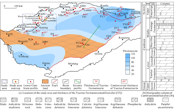
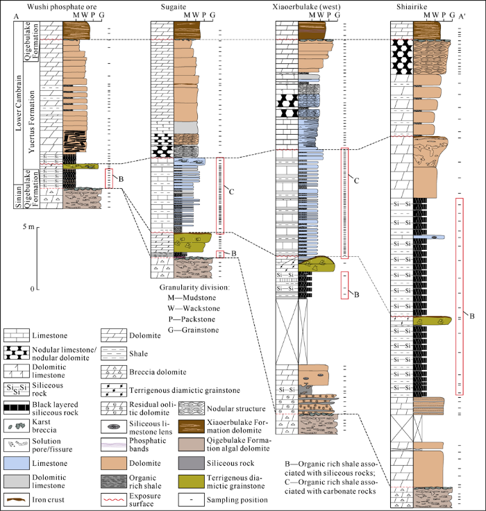
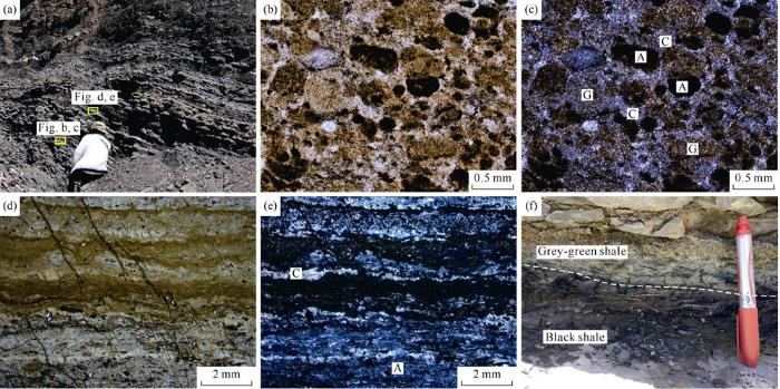
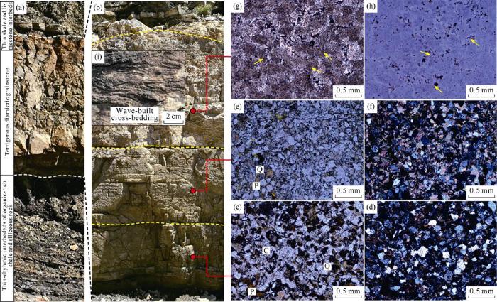
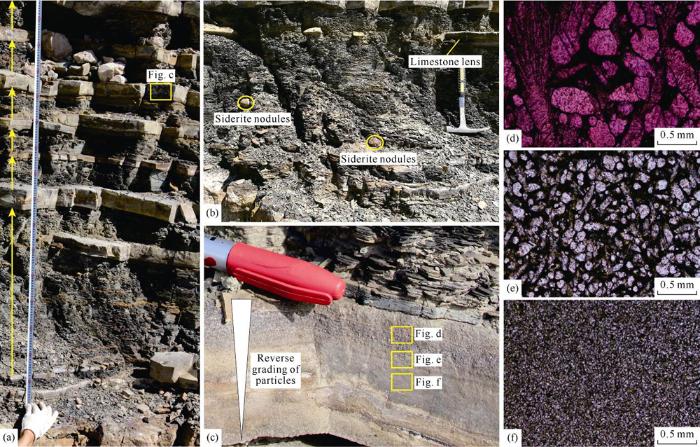
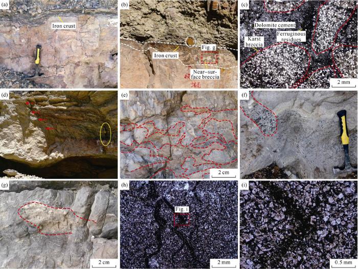


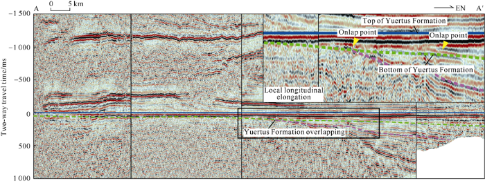
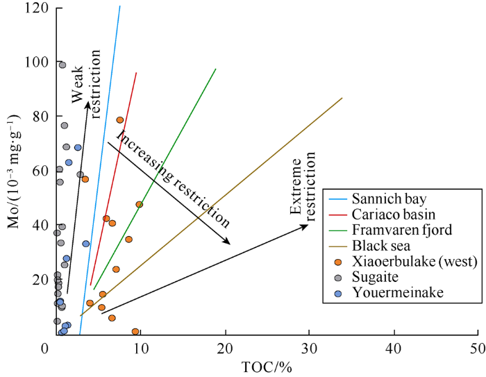
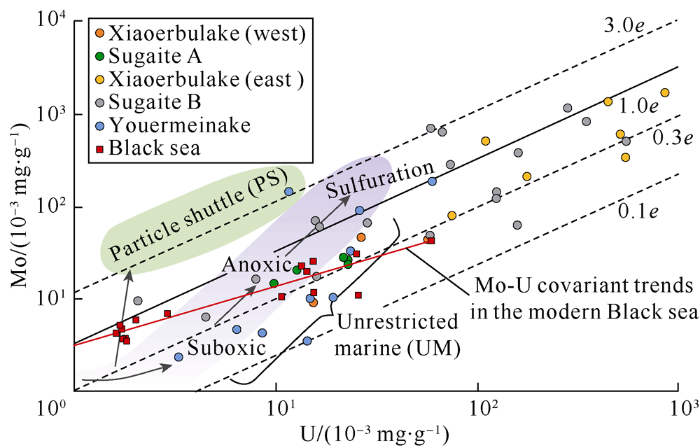
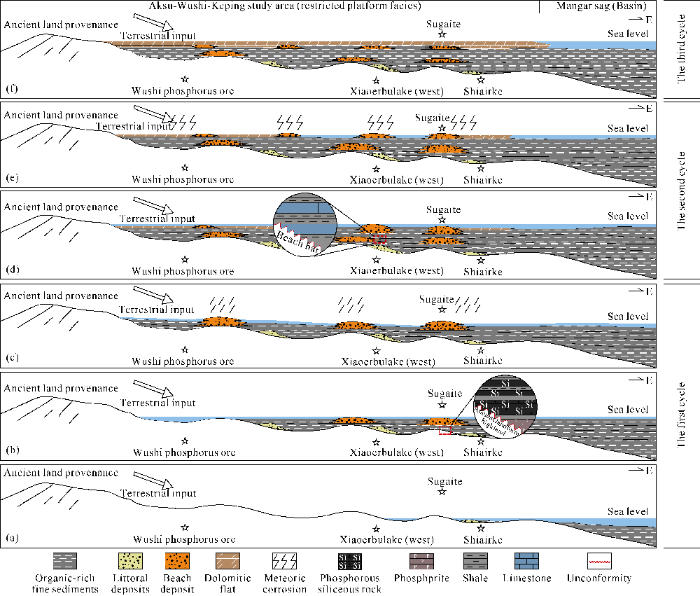

