


Introduction
The southwestern Sichuan fold-thrust belt contains lots of anticlinal structures which are the key targets for hydrocarbon exploration. Several gas fields, such as Pingluoba, Daxingxi, Qiongxi, etc., and gas bearing structures, such as Zhangjiaping, Baimamiao, Lianhuashan, Sumatou, Hanwangchang, etc., have already been found[1,2]. At present, the reserves have been discovered mainly in the terrestrial clastic layers including the Xujiahe Formation of the Upper Triassic and the Ziliu-jing Formation, Shaximiao Formation, Suining Formation and Penglaiba Formation of Jurassic. These layers present a small amount of reserves and production. Since 2010, several natural gas exploration discoveries have been made successfully in the different layers in the Sichuan Basin, including the Middle-Upper Triassic in the western Sichuan depression[3], the Sinian-Cambrian in the central Sichuan Basin[4] and the Upper Paleozoic in the northwestern Sichuan fold-thrust belt[5]. These discoveries have been continuously promoting the hydrocarbon exploration of the marine carbonate rocks and deep-buried strata. The southwestern Sichuan fold-thrust belt is located on the west of the Anyue trough in Central Sichuan[6], and it is also a tectonic unit of western Sichuan foreland basin[7]. As a result, this belt has become the key area for a new round of drilling activities, targeting at the layers including the Sinian Dengying Formation, Middle Triassic Leikoupo Formation, Middle Permian Qixia and Maokou Formations. But there are few gas fields discovered. In 2018, the high-yielding gas flow was obtained in Permian volcanic clastic rocks in the Jianyang region, east of southwestern Sichuan fold-thrust belt[8]. This successful gas exploration illustrates the potential of hydrocarbon resources in southwestern Sichuan area, and also reveals the complex processes of hydrocarbon accumulation and distribution.
The southwestern Sichuan Basin has experienced complex geological evolution processes, including Neoproterozoic rifts, stable cratons in the Early Paleozoic, paleo-uplift and denudation from the late Early Paleozoic to early Late Paleozoic, and carbonate platform from Permian to Middle Triassic and the Meso-Cenozoic multi-stage foreland basins. Especially, the Late Cenozoic rejuvenated foreland fold-thrusting has formed complex topographical features and surface structures[9]. The southwestern Sichuan area shows obvious multi-phase, multi-directional and multi-layer deformation characteristics. It makes us very difficult to identify the distribution of deep residual strata and geological structures. After the Wenchuan earthquake in 2008, the Longmenshan thrust belt and its frontal western Sichuan Basin have become a hot and frontier area for studying the active tectonics and seismic geology of the eastern margin of the Qinghai-Tibet Plateau[10,11,12,13]. The identification of active structures in the southwestern Sichuan Basin directly affects the risk assessment of hydrocarbon exploration targets. The analysis of the tectonic processes and deformations in the southwestern Sichuan area is of great significance for regional geological research, hydrocarbon exploration, and earthquake disaster assessment.
There were a lot of studies and discussions about the structural models and deformation mechanism in this region, including the regional cross-sections[10], 3D structural modeling[14,15] and abundant timing analyses[16]. However, due to limitation of hydrocarbon exploration and data quality in the southwestern Sichuan Basin, we still need to conduct sufficient and systematic analyses of deeply-buried geological structures. Based on the interpretation and analysis of reflection seismic profiles, geological and drilling data, this paper discusses the structural patterns and time series, multi-stage tectonic evolution process and stratigraphic distributions, and provides basic structural understandings for future geological study and hydrocarbon exploration
1. Geological setting
The southwestern Sichuan fold-thrust belt is located in the southwestern part of the Sichuan Basin (Fig. 1). The northwestern unit is the southern Longmenshan fold-thrust belt. The southwestern unit is the Kangdian thrust belt. The northern part is the Chengdu Basin with Quaternary sediments. And the eastern part is the central Sichuan uplift which mainly exposes Jurassic in surface. This study area now shows the basin interior propagation effect of the eastern margin of the Qinghai-Tibet Plateau, forming the surface structures characterized by multi-phase and multi-directional deformations and syntectonic deposits.
Fig. 1.
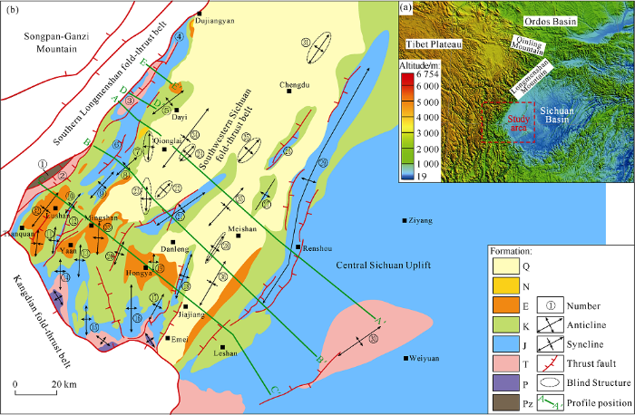
Fig. 1.
Location of the study area (a) and simplified geological map (b). ① Jintaishan klippe; ② Yintianping structure; ③ Wuzhongshan anticline; ④ Huangnigang anticline; ⑤ Guankou anticline; ⑥ Gaojiachang anticline; ⑦ Qiongxi anticline; ⑧ Pingluoba anticline; ⑨ Sanhechang anticline; ⑩ Zhangjiaping anticline; ⑪ Lianhuashan anticline; ⑫ Lianbei anticline; ⑬ Zhougongshan anticline; ⑭ Laojunmiao anticline; ⑮ Shanpingtiechang anticline; ⑯ Jianfengsi anticline; ⑰ Huatouzui anticline; ⑱ Sansuchang anticline; ⑲ Hongya anticline; ⑳ Hangwangchang anticline; ㉑ Xiongpo anticline; ㉒ Daxingchang anticline; ㉓ Daxingxi anticline; ㉔ Baimamiao anticline; ㉕ Guanyinsi anticline; ㉖ Sumatou anticline; ㉗ Yanjinggou anticline; ㉘ Dongguachang anticline; ㉙ Longquanshan anticline; ㉚ Weiyuan anticline; ㉛ Mopanshan anticline; ㉜ Lushan syncline; ㉝ Minshan syncline; ㉞ Qionglai syncline; ㉟ Danleng syncline; ㊱ Jiajiang syncline. Pz—Paleozoic; P—Permian; T—Triassic; J—Jurassic; K—Cretaceous; E—Paleogene; N—Neogene; Q—Quaternary.
1.1. Topography
The study area shows very strong active tectonics[10,11,12,13]. The topographic landforms could best reflect the Late Cenozoic tectonic coupling between the southwestern Sichuan Basin and the eastern margin of the Qinghai-Tibet Plateau (Fig. 1a). The surrounding Qinghai-Tibet Plateau has a surface elevation of more than 4000 meters, while the terrain of the Chengdu Plain has an elevation between 400-700 meters. From the orogenic belt to the basin interior, the topographic elevation rapidly decreases. The terrain drop can reach 3000-4000 meters within a distance of less than 40 kilometers. In the southwestern Sichuan fold-thrust belt, the terrain also decreases from the piedmont to the basin. And there are obvious Quaternary basinward alluvial fans and fluvial sediments in the Qionglai-Mingshan syncline, the Chengdu Plain, and so on[14,15]. These topographic landforms and sedimentary features constitute the most direct tectonic responses of the Qinghai-Tibet Plateau uplifting. Frequent natural earthquakes also indicate the strong active tectonics in the southwestern Sichuan Basin[10, 13, 17]. These active tectonics has a negative impacts on the oil and gas resources conservation, and significantly increases the hydrocarbon exploration risk and discovery difficulty in this region.
1.2. Surface structure
The ground surface shows several rows of forward or backward thrusting faults and associated folds which have consistent structural strikes with the peripheral orogenic belt (Fig. 1b).
In surfaces, the folds, faults and strata have 4 distinct strikes (Fig. 1b). The first one is the NE strike paralleling to the southern Longmenshan, represented by the main anticlinal structures such as Wuzhongshan-Gaojiachang-Zhangjiaping, Sumatou-Yanjingou, Longquanshan, etc. The second is the nearly NS strike mainly distributed in the southwestern part and represented by the anticlines including Lianhuashan, Zhougongshan, Laojunshan, Shapingtiechang, Jianfengsi, Huatouzui, etc. The third is the NEE strike which has a deviation angle more than 10° from the former ones. The NEE strike anticlines include Guankou, Xiongpo, and Weiyuan. The fourth is a NW-SE strike locally related to the Kangdian fold-thrust belt and represented by the fold structures with Permian-Triassic cores.
The statistical analysis of the main structures demonstrates those four types of strikes which are dominated by the NE-SW and NS directions (Fig. 2). The overall distribution of surface structures and outcrop strata shows that the deformation strength is weakening from west to east and from southwest to northeast.
Fig. 2.
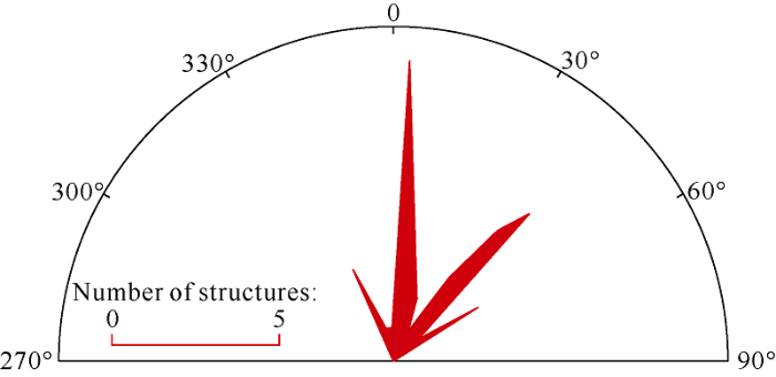
Fig. 2.
Rose diagram of the main structural strikes in the southwestern Sichuan fold-thrust belt.
1.3. Strata distribution
The surrounding orogenic belts have experienced intense structural deformation and exposed strata including large-scale basements, Sinian, Paleozoic, and Triassic. The southwestern Sichuan Basin mainly exposed the Mesozoic-Cenozoic (Fig. 1b). The outcrop strata generally become younger from piedmont to basin interior. In the southern Longmenshan belt, the basement, Sinian and Paleozoic are exposed to the surface and show overthrusting structures characterized by Paleozoic klippes (Fig. 1b). In the Kangdian fold-thrust belt, the Lower Ordovician is directly covered by the Permian. Studies show that the main body of the Caledonian Leshan-Longnüsi paleo-uplift develops in this region and results in the absence of most Paleozoic. The Hanshen-1 well on the Hanwangchang structure directly encounters the Lower Cambrian (more than 70 meters) under the Middle Permian, and then drills into the Sinian Dengying Formation (more than 200 meters). Drilling confirms the lack of Paleozoic and the complete strata from Middle Permian to Jurassic. In outcrops, the Permian is locally exposed in the core of the NW-SE strike anticlines adjacent to the southwestern margin. The Triassic becomes visible in some exterior anticlines such as the Wuzhongshan anticline in west, Weiyuan anticline in east and NW-SE strike anticlines in southwest. The Jurassic, Cretaceous, and Paleogene appear successively from the exterior to interior, reflecting the differential tectonic uplift and deformation intensity affected by the Qinghai-Tibet Plateau extrusion. The broadly distributed Jurassic and Cretaceous act as the basement background of Cenozoic tectonic and sedimentary activities. The thick Paleogene is remained in several synclines along Lushan to Jiajiang in the south part of the study area. In the north part, the sporadic Paleogene indicates the intense erosion and is covered by the Neogene and Quaternary with angular unconformities. The Neogene is also absent in most parts in the southwestern Sichuan Basin and scattered locally on the east of Wuzhongshan-Gaojiachang structural belts. In the middle and north of the study area, the Quaternary is lying on the old strata via angular unconformities and showing weak structural deformation. Only in the western and southern parts of the Qionglai area, the Quaternary is cut by the nearly NS strike faults.
2. Structural geology
The geological features of topography, strata and structures, discussed in the above section, indicate that strength and density of structural deformation are increasing in order from NW to SE and from SW to NE. The southwestern Sichuan fold- thrust belt shows various deformed structures and combination features in different tectonic units. Based on the seismic profiles, three regional cross-sections of the southwestern Sichuan Basin were constructed to illustrate the combination and distribution characteristics of upper detached thin-skin thrust structures and deeper basement involved structures (Figs. 3-5) and reveal typical geological structure patterns and deformation mechanisms in different tectonic segments.
2.1. North segment
The seismic profile of Fig. 3a is splicing together with several seismic lines, which cuts from the west to the east through the Wuzhongshan, northern Xiongpo, Longquanshan and northwest limb of Weiyuan anticline. This section clearly reveals the wedge-shaped, thin in the east and thick in the west, foreland sediments of the Triassic Xujiahe Formation and the stable sedimentary structure of the Lower Jurassic. This section further reveals the distribution of other deeply buried residual strata, including the Middle-Upper Triassic (Leikoupo Formation, Maantang Formation, and Xiaotangzi Formation), Leikoupo Formation salt layer, Paleozoic, and Sinian Dengying Formation. The Upper Triassic Maantang Formation and Xiaotangzi Formation are mainly distributed in west of the Xiongpo anticline, showing a thickness decreasing and pinching-out from the west to the east. The salt layer of the Leikoupo Formation is widely distributed in the southwestern Sichuan Basin and acts as the regional detachment vertically separating the structural deformation layers. Besides the Middle-Upper Permian, partial Lower Cambrian (pinching out from east to west), most Paleozoic are absent in the section. The Sinian Dengying Formation under the Lower Cambrian is thick in the west and thin in the east. However the Dengying Formation is also subject to erosion and directly covered by the Middle-Upper Permian in the west margin.
Fig. 3.

Fig. 3.
Seismic profile (a) and structural interpretation (b) of the north segment of the southwestern Sichuan fold-thrust belt (see
The structural interpretation shows the north segment is characterized by an upper thin-skin thrust structure detaching on the salt layer in the Middle Triassic Leikoupo Formation. The upper deformation propagates far away into the foreland. While the deeper strata under the salt detachment shows a gentle deformation.
The large displacement in the upper structural layer propagates far into the foreland basin and causes the strong deformation of the Meso-Cenozoic strata above the detachment. Those fold-thrust structures present a spaced distribution and show basin-ward decreasing intensity (shortening). This deformation characteristic indicates that there is a weak layer (ductile layer) with a lower friction coefficient under the deformed structures. And only the regional weak detachment can control the formation of this typical deformation pattern of compressional structure[18]. There are three narrow anticlinal structures with steep limbs and two in-between wide gentle synclines in the section (Fig. 3). And several small-scale faults and related folds, such as Baimamiao, Yanjinggou, etc., are developed in those synclines. While the Wuzhongshan structure adjacent to the mountain front and the distal Longquanshan anticline are typical forward thrusting structure, the Xiongpo structure and nearby anticlines in the section are backward thrust structures. In addition, under the Xiongpo anticline, there is obvious phenomenon of salt accumulation forming a salt ridge, indicating that there may be salt-related structure deformation in the study area.
The deep deformation layer under the detachment appears entirely as a large west-trending slope structure. Near the mountain front, there are a few small-scale thrust faults and low-amplitude folds which involve the basement. The deep deformation gradually weakens and disappears from the mountain front to the basin interior. This deep deformation reshapes the upper structural layer and forms local synchronous limbs with same dips. This transformation shows the deep deformation forms later than the upper detached structural layer, indicating the vertical deformation sequences in the southwestern Sichuan thrust belt. We can infer that the deformation layer above the detachment has developed earlier and then been deformed by the late formed deep basement-involved folds.
The deep and upper deformation layers in the section have different shortening (Fig. 3). The upper structural layer has a shortening of more than 14 kilometers. The deep layer has a structural shortening of about 1.2 kilometers. The displacement above the detachment fault comes from the hinterland and transmits forward into foreland. With the consideration of the displacement balance between the upper and deep deformation layers, the deep strata must have the regional length with the upper one. So there must be deep buried strata and structures under the upper thin-skin thrusts such as the Wuzhongshan belt. Therefore, it is speculated that there are deep-buried in-situ strata beneath the frontal thrust nappes in the southern Longmenshan Mountain.
2.2. Central segment
The seismic profile of Fig. 4 cuts from west to east across the structural belts including Gaojiachang, Xiongpo, Longquanshan, and southwestern limb of the Weiyuan anticline. This section is similar to Fig. 3a and can be interpreted vertically into two sets of deformation layers separated by the salt layer of the Middle Triassic Leikoupo Formation. In the upper deformation layer, the Upper Triassic Xujiahe Formation has wedge-shaped foreland sediments, thick in the west and thin in the east, and is covered by a regional stable of the Lower Jurassic.
Fig. 4.
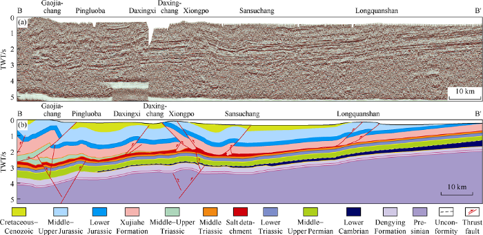
Fig. 4.
Seismic profile (a) and structural interpretation (b) of the central segment of the southwestern Sichuan fold-thrust belt (see
The lower part of the Middle-Upper Triassic (Leikoupo Formation, Maantang Formation, and Xiaotangzi Formation) residual strata are mainly distributed on the west side of the Xiongpo anticline. The Upper Triassic Maantang Formation and Xiaotangzi Formation are also distributed in the west of the Xiongpo anticline, showing a thickness decreasing and pinching-out from the west to the east. The number of thrust structures in the upper deformation layer is more than that in the north segment and the deformation intensity are stronger. For example, the Daxingxi and Sansuchang structures separately on the both sides of the Xiongpo anticline have larger width, fault displacement and fold amplitude.
In Fig. 4, the Daxingchang anticline in the deep deformation layer is located under the upper Xiongpo structure and showing a large-sale basement-involved structure. This deformation involves the basement, Dengying Formation, Paleozoic, and partial Mesozoic under the salt layer and causes the folding and uplifting of the overlying salt detachment and upper early-formed deformation layer. This kind of transformation between the upper and deep deformation appears obviously in the deep structures of the Gaojiachang and Pingluoba. It can be directly observed from the section that the thrust faults derived from the basement penetrate the salt layer and cause the concordant folding deformation of the upper, deep and in-between salt detachment. The local concordant deformation indicates the late-stage formation of the deep structure. The frontal large-scale thrusts and folds above the detachment (such as Xiongpo and Longquanshan) should be formed before the deep structure. Moreover, the upper deformation layers have a larger total shortening than that of the deep layer. This inconsistent shortening reveals that the deep deformation layer extends under the upper fold-thrust belts, forming the blind in-situ structure in the southern Longmenshan Mountain
2.3. South segment
The surface and underground structures show more complex geological phenomena in the south segment than in the central and north area. From both the seismic and interpretation profiles in Fig. 5, the deep and upper deformation layers of most thrust structures have consistent deformation geometry. Those folds and faults can be interpreted coherently through the vertical section and have no obvious detachment and separation of the deformation layers. However, the distal Longquanshan structure in the section east shows the combination of the clear upper-layer thrust structure and the deep stable west-dipping slope structure, indicating the existence of the early-formed upper detached and basin-ward transferred thin-skin thrust structures. This phenomenon shows that the south segment also develops double-layer deformation separated by the regional salt detachment. This fact provides the idea for the rational structural interpretation of the seismic images with poor quality in the south area. The regional salt layer controls the upper layer deformation which is strongly reshaped by the deep basement-involved fold. As a result, the south segment visually shows structural features characterized by basement-derived deformation.
Fig. 5.

Fig. 5.
Seismic profile (a) and structural interpretation (b) of the south segment of the southwestern Sichuan fold-thrust belt (see
Based on the seismic reflection characteristics and the kinematic deformation mechanism, we construct a regional structural section across the Zhangjiaping, Hanwangchang and Longquanshan anticlines in the south segment (Fig. 5). According to the interpretation results, there is a set of salt detachment across the section, which controls vertical superimposition of deformation layers. There are obvious differences between thrust faults and their related folds above and below the detachment. Moreover, the final detachment fault shows a curved geometry which is deformed by the deep-buried folds.
The upper deformation layer above the salt detachment can be interpreted into 6 anticlinal belts and 5 synclinal belts, forming a series of fold-thrust structures including Zhangjiaping, Lianhuashan, Hanwangchang, Sansuchang and Longquanshan, etc. In the eastern part of the section, the distinct structures of Sansuchang and Longquanshan show a large thrust displacement. But in the central and western part of the section, many thrust faults only show a small fault displacement and the structural shortening mainly forms fault propagation folds. The forward and backward thrust faults in the upper layer extend downward and root in the underlying regional salt detachment. Similarly, under the Hanwangchang structure in the section middle, the local salt accumulation indicates the salt-related deformation occurs.
The structures under the salt detachment layer are composed of several large-scale anticlines and synclines, which are lifted gradually from the mountain front to the distal Weiyuan anticline. This deformation style shows that the former large-scale slope is suffered the structural transformation of the basement-involved folding in the late stage. The deep-buried anticlines of the Lianhuashan and Hanwangchang are the typical ones which show the large-scale folding deformation involving the basement. Secondary thrust fold structures are developed at the core or bend part, forming local pop-up structures. The southern part of Hanwangchang structure illustrates that the deep thrust cuts through the overlying salt detachment into the upper layer (Fig. 6), thus forming the today’s complex fold-thrust structure. In Fig. 6, we can observe not only the thrust fault rooted in the salt detachment and subsalt former folding deformation, but also the late-stage concordant faulting of the deep and shallow deformation layers.
Fig. 6.

Fig. 6.
Deep-rooted faults cutting through the salt detachment in the Hanwangchang structure, showing late-stage concordant deformation (see
The deep structures of the south segment obviously reform the salt detachment and the upper deformation layer, forming consistent geometry between the deep and upper structural layers. This deformation pattern is particularly distinct in the synclines. First, it forms the narrow and steep syncline structure in the south segment. Second, it has similar stratigraphic occurrence features from shallow to deep (such as the east limbs of the Lushan syncline and Mingshan syncline). The structural geometry shows the transformation process of upper deformation layer by deep-buried folding. This recognition further illustrates the rationality of the structural kinematics process of the early-stage upper detached thin-skin thrusts and the late-stage integral basement-involved deformation in the southwestern Sichuan thrust belt. In addition, we can interpret in this profile that there may be several concealed rifts under the Sinian. The existence of the rift boundaries may locally control the deformation positions and orientations of the late-formed deep structures (Fig. 5).
The cross-section of the south segment shows a stratigraphic sequence similar to the above two regional sections (Fig. 5). In the upper deformation layer, the Upper Triassic also shows the wedge-shaped foreland strata, and the Jurassic and Cretaceous show the relatively stable regional sedimentary structure (Fig. 5). Limited by the poor quality of seismic profile, it is difficult to identify some residual strata of Middle-Upper Triassic such as Leikoupo Formation, Maantang Formation and Xiaotangzi Formation. In the deep structural layer, Most of the Paleozoic is also absent. The remaining Lower Cambrian is thinning and pinching out from east to West in the deep structural layer of the Hanwangchang structure and is directly covered by the Permian. There is Sinian Dengying Formation under the Cambrian. The Dengying Formation in the west has been denuded and directly overlaid with the Middle-Upper Permian. Moreover, the rifts under Sinian Dengying Formation may be filled with thick Presinian sediments.
Based on the above analyses of three regional structural cross-sections, we can establish the structural pattern. The upper NE strike thrust structures are formed above the salt detachment in the early compression stage and the displacement transmits far into the foreland. The deep NS strike basement-involved structures form in the late stage and transform the upper deformation layer. This multi-stage, multi-directional and multi-level tectonic process finally forms the complex structures in the southwestern Sichuan fold-thrust belt.
3. Deep geological structure
3.1. Deep concealed rifts in Nanhua system
Previous studies have focused on the rift basin under the upper thin-skin thrusts and deduced its outline[6, 19]. It was inferred that the rift was filled with the Silurian to Carboniferous through the analyses of regional tectonic background[6, 19]. These rifts show a NE-SW strike and to a contain extent control the locations and strikes of upper layer structures such as Hanwangchang and Xiongpo[19]. After the detailed analyses of several 2D and 3D seismic data, we recognize that the deep-seated rifts are buried under the Upper Sinian Dengying Formation. Furthermore, the Lower Sinian Doushantuo Formation is not well developed in southwestern Sichuan area[20]. Therefore, it is concluded that the deep-buried rifts appeared in the Presinian Nanhua period and might have been filled with thousands of meters thick sediments.
The deep-buried rifts are mainly depicted indirectly via seismic images because there is no drilling data for horizon calibration. As discussed above, the regional structural profile has shown several Presinian rifts inter-bedded horizontally by the basement fault blocks under the Sinian Dengying Formation. Several other seismic sections also showed some characteristic geological phenomena which can be used to define the rift structure, including normal faults and related inversion features (Fig. 7a-7c), the fault plane reflection (Fig. 7c), seismic differences and interruptions (Figs. 3-5), the locally identified sedimentary overlaps (Fig. 7d), and the uplift and depression structures (Fig. 7e). Observed from the limited reflection seismic data, the strata thickness in the rift can reach thousands of meters and the subsidence center is located under the structural belt along the Hanwangchang and eastern Xiongpo. Limited by the poor quality and seismic line density, it is difficult to accurately characterize the rift structures and infilling strata thickness. However, the regional 2D seismic profiles and Daxingchang 3D seismic data reveal that the rift’s strike is near NS direction which is consistent with some NS strike surface thrusts. A number of boundary normal faults and depressions were roughly outlined under the upper thin-skin thrusts to illustrate the Presinan rifts and adjacent bugles (Fig. 7a).
Fig. 7.

Fig. 7.
Structural features of the deep-buried Presinian rifts in Southwest Sichuan fold-thrust belt.
These rifts have underwent the Late Cenozoic tectonic compression and resulted in inversion structures which may control the development of the later deep NS strike basement-involved deformation. For details, the Sinian and overlying strata above the boundary normal fault are folded and bent on a small scale, indicating that the rift basin is subject to tectonic compression (Fig. 7). The strata in the rift are thrusting along the pre-existing normal fault and make the upper strata bend and deform, finally forming the deep local thrusts and folds. On the contrary, the phenomenon of the deep compressional structures can indicate the existence of rift structures and their approximate locations.
3.2. Platform-margin of the Sinian Dengying Formation
The discovery of the Anyue giant gas field in middle Sichuan Basin reveals that there is a geomorphologic relief at the top of Upper Sinian Dengying Formation. This relief geometry forms the tectonic units of uplift and depression. In the depression unit, there is a "rift trough"[6], and in the uplift, there are several steep scarps in different members forming the platform-margin belts and paleo-uplifts[21]. Current studies paid more attention to the eastern side of the "rift trough" on the stratigraphic sequence and structural geometry of Sinian Dengying Formation platform. It’s not clear on the west side platform in the southwestern Sichuan Basin. Previous studies have found that the stratigraphic sequence and the stepped platform margin belts of the Dengying Formation are well developed in the Jiulongshan area of the northwestern Sichuan Basin. We conducted a detailed interpretation of a regional seismic profile from the northwestern to southwestern Sichuan area, and use the bed thickness comparison to define the Dengying Formation stratigraphy in the southwestern Sichuan Basin. The horizons can be continuously traced in that seismic profile from northeast to southwest and show clear the geomorphologic relief of the Dengying Formation top. Generally, complete Dengying Formation is developed with a relatively large thickness in the northwest. Although most of the Dengying Formation carbonate deposits are absent, the contemporaneous heterotopic strata would been developed in the rift troughs and covered by overlying thick Lower Cambrian. However, the strata thickness of Dengying Formation in the Southwest is thinner than that in the Northwest. So it is inferred that Dengying Formation carbonate strata in southwestern Sichuan area is mainly composed of the 1st to the 2nd members. The Dengying Formation is gradually thickened southwestward, and the carbonate bed is thickened abruptly across two obvious scarps (platform margins) in 2nd member (Fig. 8).
Fig. 8.

Fig. 8.
Distribution of the residual Upper Sinian Dengying Formation.
The different members of Dengying Formation have differential space distribution. The scarps (platform margins) indicated by stratigraphic boundary extend from south to north almost in NS strike, and show different members eastward pinching out. Based on a limited quantity of seismic data, we depicted two platform margins (scarps) defined as the upper and lower margins of the 2nd member of Dengying Formation. These two margins are separated from eastern platform margin belt in the Gaoshiti-Moxi area in the east with a big “rift trough” (Fig. 8).
The seismic images clearly show the stratigraphic sequences of Dengying Formation and the angular contacts at the top of Dengying Formation (Fig. 9). The deep Dengying Formation in the west of Dayi-Leshan linal belt has thicker strata of the 2nd member and is also at the topographic high in (Fig. 9a-9c). Toward the east to the Anyue deep depression, the 2nd member gradually thinned and successively exposed the lower part and then the 1st member, showing obvious depressed landforms (Fig. 9d-9f). Compared with those in the northwest Sichuan Basin, there are several similar structural and sedimentary characteristics: (1) There are two east-trending scarps (platform margin belt) and in-between several tens of kilometers wide gentle slope platform. The eastern side of the lower margin mainly exposed the 1st member and is absent of carbonate rocks of the upper members. (2) That no normal faults underlie the margin scarps indicates that the scarp may be controlled by the contemporaneous heterotopic deposition. And the Dengying Formation shows Late Cenozoic folding related to deep basement deformation. (3) The Lower Cambrian filled up the depression in complementary way with the strata thin in the east and thick in the west, and had been covered by the Permian system with an unconformity. The Lower Cambrian is in contact with the different members of Dengying Formation at different structural positions, forming sedimentary overlaps. (4) The Sinian Dengying Formation and Cambrian were uplifted by Late Caledonian tectonic movement and underwent large-scale denudation, forming the Late Paleozoic regional paleo-uplift and Sinian outcrop which was directly covered the Middle Permian (Figs. 3-5).
Fig. 9.

Fig. 9.
Typical platform margins in the deep southwest Sichuan Basin (see
3.3. Wuzhongshan over-thrust structure
In recent years, several gas fields, such as Xinchang and Pengzhou, with proven reserves of 100 billion cubic meters have been discovered in the middle segment of western Sichuan Basin. Their target layers are the weathered karst reservoirs in the Middle-Upper Triassic Leikoupo Formation and Maantang Formation. The Wuzhongshan structural belt is an anticlinal belt on the western edge of the southwestern Sichuan fold-thrust belt and is close to the Soutern Longmenshan Mountain. Here, we conduct the structural analysis on two seismic profiles. One profile cuts the south part of the structure (Fig. 1b, D-D°) and the other section cuts the north (Fig. 1b, E-E°). Combining with previous regional deformation analyses, we establish new structural interpretation models for this structure (Fig. 10).
Fig. 10.

Fig. 10.
Structural interpretation model of the Wuzhongshan structure (see
In cross-section, the Wuzhongshan structure is separated into two sets of large deformation units by the regional middle Triassic detachment. The detachment fault in the section may be just a part of the upper fault flat in a fault bend fold[22]. Furthermore, the whole upper deformation layer above the detachment is the core and forelimb of a fault bend fold and is complicated by several secondary fold-thrust structures. Finally, the upper layer along the strike shows different fold-thrust structural styles and stratigraphic occurrences. Considering the thickness balance, it is inferred that the lower fault flat (lower detachment fault) is located at the Sinian bottom. This lower detachment is also locally developed in the Daxingchang and Hongya anticlines and represented by several small-scale fold-thrust structures involving Sinian and Paleozoic (Fig. 5). The deep layer under the upper fault flat (detachment fault) shows a relatively stable stratigraphic structure which is controlled by the forward or backward thrust structures. This deep-seated deformation is originated from the basement and forms a low amplitude basement-involved folds which finally uplifted and deformed the upper structural layer.
4. Multistage tectonic evolution
Based on the understanding of the tectonic kinematics, the section was balanced using the so-called sinuous bed method (Figs. 4 and 11). Then we established the multi-stage tectonic evolution process of the southwestern Sichuan fold-thrust belt (Fig. 11). The southwestern Sichuan area has experienced a sophisticated tectonic evolution history including the Neoproterozoic rift basin, the marine Craton basin during the Sinian-Middle Triassic and the intra-continental basin during the Meso-Cenozoic, resulting in the complex paleo-structures and residual strata distribution in different stages.
Fig. 11.
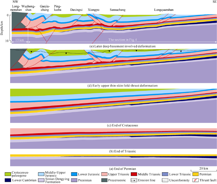
Fig. 11.
Multi-stage tectonic evolution of the southwestern Sichuan fold-thrust belt (Section B-B° in
Before Sinian, influenced by the Rodinia supercontinent breakup[23,24], several rifts are developed in this area and show the structural style of graben or fault depression (Fig. 7b-7e). Then this area is covered with the Sinian. During the development of the Upper Sinian Dengying Formation (Fig. 11a), the differential sedimentation formed a stepped carbonate platform and two platform margin belts, and constructed a "rift trough"[6] filled with the Lower Cambrian (Fig. 11a). This structural combination of the Sinian and Cambrian indicates that the deep layer in the study area has the similar petroleum system with the middle Sichuan Anyue giant gas field[25,26]. At the end of Silurian, the large-scale uplift and denudation made this area the core of Caledonian Leshan-Longnüsi paleo-uplift. From east to west, the uplift and denudation are gradually strengthened. In the west margin, the Upper Sinian Dengying Formation is exposed to the surface and the upper Lower Paleozoic is completely denuded. Part of the Lower Cambrian is remained in the middle-east part and pinched out to the west along the Qiongxi and Hanwangchang structural belts. That the Devonian and Carboniferous are also absent in the deep southwestern Sichuan Basin reflects the successional tectonic uplift and denudation during the early stage of the Late Paleozoic. Since the Middle Permian, the regional transgression formed a large range of carbonate platform deposits from the Middle Permian to the Middle Triassic. The exposed Dengying Formation and the Lower Cambrian are directly covered by the Permian (Fig. 11a). At the end of Middle Permian, Emeishan rifts and volcanic activities form large-scale igneous rocks with overflow facies. Then during the Late Triassic, southwestern Sichuan foreland basin was filled with wedge-shaped terrestrial sediments, thick in the west and thin in the East. And its forebulge was located between the Longquanshan and the Weiyuan anticline (Fig. 11b). As for the Sinian and Permian strata, the tectonic unit between the Xiongpo and Longquanshan is the structural high which is a favorable area for oil and gas migration and accumulation. Then the Jurassic and Cretaceous intra-continental foreland sedimentation further strengthened that wedge-shape sedimentary structure and reshaped the early forebulge into the slope (Fig. 11c). Generally, the deformation in the southwestern Sichuan Basin is characterized by the subsiding and tilting before Paleogene, and shows few large-scale thrusting and folding. During Cenozoic, multi-phase strong rejuvenated foreland tectonic deformation forms present complex geological structure (Fig. 11d-11e). The deformation of the Mesozoic and Cenozoic above the regional salt detachment initially forms complex upper compressional structures with the NE-SW strike (Figs. 3-5). And the deep layer under the detachment is characterized by the later basement-involved deformation, forming the present-day NS strike fold-thrust structures both in the upper and deep layers.
5. Potential hydrocarbon exploration areas
According to the above analysis, Presinian rift sequence, carbonate platform of Dengying Formation, Permian and Mesozoic strata are buried under the surface southwestern Sichuan fold-thrust belts. The current exploration activities demonstrate that Dengying Formation, Qixia-Maokou Formation, Middle-Upper Triassic and Permian volcanic rocks are the target reservoirs for drilling in the near future. From the structural angle, favorable exploration strata and belts are developed in the structural deformation layers above and below the salt detachment. The dominant anticlinal belts are mainly targets for exploration at present, such as Leikoupo Formation in Wuzhongshan, Gaojiachang and Daxingchang, etc. The new structural belts newly determined in this paper will also be the potential hydrocarbon exploration areas and targets, mainly including in-situ Sinian and Permian in the deep layer of Wuzhongshan, and deep-buried Presinian rift structural belts along Hanwangchang, Sinian Dengying Formation carbonate platform margins, Indosinian paleo-uplift on the east side of Longquanshan, etc.
5.1. Deep-buried rift structure belt
Before Sinian, there were large-scale extensional tectonic activities and rift basins in Yangtze, North China and Tarim craton. From the reflection seismic data, we can interpret several grabens or faulted depressions which might be filled with thousands of meters thick sediments. High-quality source rocks have been found in the Presinian strata in the Sichuan Basin and adjacent areas, showing huge potential for hydrocarbon generation[27,28]. Nowadays, the geological researches and petroleum explorations confirm that the rift basins have huge oil and gas resources, and the rift’s interior and peripheral structural belts are the key areas for oil and gas exploration. There are paleo-horst structural belts and positive inversion anticlinal belts in the deep rifts, in which the long-term inherited paleo-uplifts are favorable for the hydrocarbon formation and preservation. As a whole, the deep rift structure has kept stable for a long geological period, and only been deformed strongly during the late Cenozoic. If the effective source-reservoir-cap assemblage is well developed in the rift related structures and the trap integrity is well maintained, the deep buried rift structure will have promising oil and gas exploration potential.
5.2. Multi-layered Wuzhongshan anticlinal belt
The structural interpretation documented by this study shows that the Wuzhongshan structure is composed of upper over thrust nappes and deep in-situ strata. Based on this new structural model, it is suggested that there are strata repetition of Sinian, Permian and Middle-Lower Triassic. The upper deformation layer above the salt detachment also has the stratigraphic sequence including the Sinian Dengying Formation, Middle-Upper Permian and Meso-Cenozoic. The Middle Permian[29,30], Leikoupo Formation[31,32] and Upper Triassic Xujiahe Formation[2] contains high-quality hydrocarbon source rocks which can act as the material basis for Dengying Formation, Middle Permian and Middle-Lower Triassic reservoirs[33,34,35]. The main risk for the upper layer structures is poor preservation conditions caused by the Late Cenozoic strong thrust deformation.
The deep-buried in-situ structures under the salt detachment comprise the Presinian, Sinian, Permian, Lower Triassic and lower part of the Middle Triassic. The reservoirs include the weathered Dengying Formation and Middle Permian dolomites. The deep Wuzhongshan structure has a better preservation condition because of the weak deformation during the Late Cenozoic. Moreover, the deep-seated in-situ structure is located at the core of Leshan-Longnüsi paleo-uplift, lacking effective source rocks such as the Lower Cambrian and Lower Silurian. However, recent studies reveal that the Middle Permian contains effective source rocks. So the source rocks of other strata still need to be further determined. Furthermore, this structural belt is near the Piedmont and has experienced the multi-level foreland tectonic processes during Meso-Cenozoic. The deep layer may have developed the Indosinian or Yanshanian fold-thrust structures which are favorable for the oil and gas accumulation. Therefore, the deep-seated in-situ structure in the Wuzhongshan belts is also an area worth exploring in the future. It is necessary to carry out a comprehensive evaluation of the petroleum geological conditions and ascertain the favorable traps.
5.3. The Upper Sinian Dengying Formation
The Upper Sinian Dengying Formation currently is one of key exploration layers with high-quality dolomite and karst reservoirs in the 2nd and 4th members. The Upper Sinian Dengying Formation is distributed broadly in the southwestern Sichuan area (Fig. 8). Two platform margins are developed in the east area of The Daxingchang-Hanwangchang structural belt. And in the west area, the Sinian Dengying Formation has suffered large-scale denudation before the Middle Permian and may develop high-quality karst reservoirs. In terms of structural stability, the middle and north segments have experienced weak deformation during the Late Cenozoic and form the low amplitude folds. But the south segment, including the Hanwangchang structures, shows strong basement-involved thrusts and folds which have poor structural stability and preservation condition. So the favorable exploration targets in the deep layer are the paleo-structures formed before the Cenozoic and kept relatively stable during the late-stage deformation, and the NE-SW strike anticlinal structures formed in the Early Cenozoic. The favorable areas of the Sinian Dengying Formation are the upper margin belt and near anticlinal belts under the Daxingchang. During the geological evolution, this structural belt has always been located in the high structural position and covered by the Lower Cambrian cap-rocks. The anticline traps are well preserved during late stage (Fig. 11). In addition, the Lower Cambrian high-quality source rocks remain in the eastern area and form favorable conditions for lateral and vertical hydrocarbon migration and accumulation (Fig. 11a).
5.4. Frontier paleo-uplift belt
The current explorations and studies show that the Indosinian tectonic movement has a significant impact on the hydrocarbon accumulation in the Sichuan Basin. So the paleo-structures formed during the Indosinian period are the key targets for oil and gas exploration. According to the multi-stage tectonic evolution, the western Sichuan Basin is a peripheral foreland basin during the Indosinian period and the whole southwest Sichuan region is located at the foreland slope and forebugle (Fig. 11b). The eastern area of today’s Longquanshan structure is the forebugle characterized by the paleo-uplift. From the Dengying Formation depositional stage to the Xujiahe Formation depositional stage, there is a wide and gentle anticline forming a high place for early-stage oil and gas accumulation. Although during the Jurassic to Cenozoic, this forebulge has suffered structural transformation of tilt and uplift, and nowadays shows a western trend slope structure with good tectonic stability (Fig. 11c-11e). This stable early paleo-uplift may form structural-lithological traps or tight oil and gas exploration fields, which has been conducted successfully in the Ordos Basin[36]. Therefore, the Indosinian foreland forebugle in the front of Southwestern Sichuan fold-thrust belt is also a new potential area for oil and gas exploration.
6. Conclusions
Southwestern Sichuan fold-thrust belts have experienced multi-stage tectonic evolution processes including Presinian rifts, Sinian-Middle Triassic craton basins and Late Triassic- Cenozoic foreland basins, and developed characteristic strata distribution and structural deformation. During the Presinian period, several NS strike rifts were developed and characterized by the grabens and horsts. The Upper Sinian Dengying Formation is thick in the West and thin in the East, and contains two prominent platform margin belts. The residual Lower Cambrian is thin in the West and thick in the East, and westward pinches out, indicating that there are high-quality source rocks in the middle and east part of southwestern Sichuan Basin. At the end of Silurian, the western region of the study area was greatly uplifted and denuded. The Dengying Formation and Lower Cambrian were exposed to the surface and directly covered by the Middle Permian, forming the regional significant unconformity. From the Middle Permian to the Middle Triassic, the regional transgression formed a broad carbonate platform deposits. Since the Late Triassic, the foreland basin has been filled with wedge-shaped sediments. Finally, the Late Cenozoic rejuvenated foreland fold-thrusting has formed complex topography and detached thrusts.
The southwestern Sichuan area shows a double-layer deformation separated by the salt detachment in the Middle Triassic Leikoupo Formation. The upper layer deformation is dominated by the NE-SW strike thrust structures. The displacement above the detachment initially propagates far into the foreland basin. The deep layer is characterized by the nearly NS strike basement-involved folds. The late-formed deep structures deform the detachment and the upper layer, forming concordant geometry in the seismic profiles. The south segment strongly is characterized by the late-stage strong basement-involved folding. But the middle and north segments show the upper detached thrusting and the weak deep structural deformation. The structural shortening is at least 14 km in the upper deformation layer, indicating deep-seated in-situ strata under the salt detachment in the Wuzhongshan structural belt. So the Wuzhongshan anticline can be interpreted into a double-layer structure which is controlled by the salt detachment. The upper structural unit is an over-thrusting fault bend fold with different thrust features at the southwest and northwest ends. The deep unit is a deep-seated stable in-situ sequence composed of the Sinian, Permian and Lower Triassic, and shows weak basement-involved folding.
The southwestern Sichuan fold-thrust belt develops Presinian rift sequence, Sinian Dengying Formation carbonate platform, and complete Permian and Mesozoic. The favorable exploration strata in the deep layer include the multi-layer and multi-type reservoirs in the Dengying Formation, Permian, Middle-Upper Triassic. The main risk is the lack of high-quality hydrocarbon source rocks of the Lower Cambrian. However, from the structural angle, the favorable exploration strata and belts are developed separately in the deformation layers above and below the regional salt detachment. And the anticlinal structural belts in the deep layer are the key targets for current explorations. Furthermore, the potential exploration areas and belts include the deep-buried in-situ Sinian and Permian in wuzhongshan structural belt, the Presinian rifts and their related inversion structures, the platform margin belts of Sinian Dengying Formation, and the frontier Indosinian paleo-uplift in the east of Longquanshan.
Acknowledgments
Thanks to the faculty of Mining and Metallurgy Engineering of Amirkabir University of Technology and Islamic Azad University and also thanks to the Research and Development branch of Petroleum Ministry for the provision of data. Finally, we are grateful to Alireza Shiri for his invaluable assistance and cooperation.
Reference
New ideas of gas exploration in western Sichuan Basin
DOI:10.3787/j.issn.1000-0976.2009.06.002
URL
[Cited within: 1]

In order to find new blocks and plays for gas exploration in the western Sichuan basin, three structural sequences and six sedimentary sequences are recognized based on over 10 outcrop sections, drilling data of over 40 wells and seismic data in the study area. Epicontinental estuarine facies, continentaloceanic transitional facies, and enclosed to semienclosed foreland basin facies are recognized in the study area. Different sedimentary systems and sandbodies are developed in these basins and they form different plays and reservoir types. The following proposals are presented. The focus of exploration should be shifted from the second member of the Triassic Xujiahe formation at present to its fourth and sixth members, from the Xujiahe formation to both the marine and continental facies (the Jurassic red bed), and from anticlinal traps to nonanticlinal traps and shale gas reservoirs. The exploration areas also should be shifted correspondingly from Qiongxi, Pingluoba, Baima and Songhua blocks to Wuzhongshan and Lianhuashan blocks, as well as Dayi, Guankou, Sumatou, Yanjinggou, Meishan and Hanwang blocks. The exploration methods, ideas, engineering and technologes should also be upgraded.
Major controlling factors of gas pooling and exploration directions in the Upper Triassic in the western Sichuan Basin
DOI:10.3787/j.issn.1000-0976.2012.10.002
URL
[Cited within: 2]

The Upper Triassic sedimentary sequence is thick in the western Sichuan foreland basin and has multiple indigenous gas plays. On the basis of analyzing the main reservoir forming conditions and in combination with regional structures and hydrocarbon evolution as well as their configuration relationship between time and space, this paper discusses the mechanism and major controlling factors of hydrocarbon migration and accumulation. The Upper Triassic source rocks in the western Sichuan Basin are featured by great thickness, high TOC contents, and heavy hydrocarbon generation intensity, which are all favorable conditions for gas accumulation. The geometric configuration is the key to gas accumulation, hydrocarbon generation intensity controls the abundance of gas reservoirs, the superimposition of structures controls the quality of gas reservoirs, and large faults control the modification, recombination and fullness of gas reservoirs. This paper also presents the future exploration directions. It is highly possible that structural trap gas reservoirs with normal pressure occur in the southern part of the western Sichuan Basin, where the Laojunshan structures on the downthrown walls of No.3 and No.1 faults and the Sangyuan structure on the Qiongxi1 fault are the major targets of structural trap gas reservoirs. Lithologic gas reservoirs with normal pressure may occur in the northern part of the western Sichuan Basin, where the Jianmen Longgang area between the Zitong sag and the Jiulongshan structure is the target of lithologic gas reservoirs.
Forming conditions of Pengzhou large gas field of Leikoupo Formation in Longmenshan piedmont tectonic belt, western Sichuan Basin
Formation, distribution, resource potential, and discovery of Sinian-Cambrian giant gas field, Sichuan Basin, SW China
Oil and gas geochemical characteristics and source of Devonian of well ST3 in Northwest Sichuan Basin
Discovery of intra-cratonic rift in the Upper Yangtze and its control effect on the formation of Anyue giant gas field
Longmen Shan fold-thrust belt and its relation to the western Sichuan Basin in central China: New insights from hydrocarbon exploration
DOI:10.1306/03230605076 URL [Cited within: 1]
Distribution and gas-bearing properties of Permian igneous rocks in Sichuan Basin, SW China
DOI:10.1016/S1876-3804(19)60003-0 URL [Cited within: 1]
Sandbox modeling of evolving thrust wedges with different pre-existing topographic relief: Implications for the Longmen Shan thrust belt, eastern Tibet
DOI:10.1002/2016JB013013 URL [Cited within: 1]
Uplift of the Longmen Shan and Tibetan plateau, and the 2008 Wenchuan(M=7.9) earthquake
DOI:10.1038/nature07837
URL
PMID:19279635
[Cited within: 4]
The Longmen Shan mountain range, site of the devastating 12 May 2008 Wenchuan (M = 7.9) earthquake, defines the eastern margin of the Himalayan orogen and exhibits greater topographic relief than anywhere else in the Tibetan plateau. However, before the earthquake, geodetic and geologic surveys measured little shortening across the range front, inspiring a vigorous debate about the process by which the topography of the mountain belt is produced and maintained. Two endmember models have been proposed: (1) brittle crustal thickening, in which thrust faults with large amounts of slip that are rooted in the lithosphere cause uplift, and (2) crustal flow, in which low-viscosity material in the lower crust extrudes outward from the Tibetan plateau and inflates the crust north and east of the Himalayas. Here we use balanced geologic cross-sections to show that crustal shortening, structural relief, and topography are strongly correlated in the range front. This suggests that crustal shortening is a primary driver for uplift and topography of the Longmen Shan on the flanks of the plateau. The 2008 Wenchuan (M = 7.9) earthquake, which ruptured a large thrust fault along the range front causing tens of thousands of fatalities and widespread damage, is an active manifestation of this shortening process.
Structural model of 2008 Mw 7.9 Wenchuan earthquake in the rejuvenated Longmen Shan thrust belt, China
DOI:10.1016/j.tecto.2009.08.040 URL [Cited within: 2]
Late Cenozoic east-west crustal shortening in southern Longmen Shan, eastern Tibet: Implications for regional stress field changes
DOI:10.1016/j.tecto.2014.03.033
URL
[Cited within: 2]
The co-seismic slip sense of the 2008 Wenchuan earthquake (Mw 7.9) has resulted in the present east-west (E-W) crustal shortening and oblique thrusting across Longmen Shan, which are inconsistent with southeast-directed thrusting that occurred during the late Triassic. Although the two major periods of compressional deformations in Longmen Shan have long been recognized, the fault slip rate of the late Cenozoic deformation and the initial E-W crustal shortening remain poorly investigated. This study confirms the fault slip rate in the Dayi Thrust Fault System (DYFS) based on data from the petroleum industry and shallow seismic reflection profiles, and well data. Folded late Pliocene to present strata are analyzed and yield with an average slip rate of 0.2 mm/yr on the DYFS. An average fault slip rate of 0.25 mm/yr is then obtained from the late Pliocene to present for the range front thrust of Longmen Shan. The E-W crustal shortening is investigated by using 3-D seismic reflection data, interpreting satellite image, and conducting a field investigation in the DYFS to determine stress field changes during the late Cenozoic. Two-period tectonic deformations during the late Cenozoic are found in the DYFS, which correspond to the NE- and NS-trending structures, respectively. The activities of the DYFS may reflect a change in the field direction of the regional-stress from NW-SE during the Oligocene to early Pliocene to E-W during the late Pliocene to Holocene, which is consistent with the present stress measurements. The 120 km NS-trending structures in the southern Longmen Shan range front as well as the Wenchuan earthquake co-seismic ruptures are assumed to reflect the active, E-W crustal shortening in Longmen Shan. (C) 2014 Elsevier B.V.
Structural geometry of the source region for the 2013 Mw 6.6 Lushan earthquake: Implication for earthquake hazard assessment along the Longmen Shan
DOI:10.1016/j.epsl.2014.01.018
URL
[Cited within: 3]
The 2013 Mw 6.6 Lushan earthquake occurred in the Longmen Shan fold-and-thrust belt, Sichuan Province, China, near the five-year anniversary of the devastating 2008 Mw 7.8 Wenchuan earthquake. To define the fault that generated the 2013 earthquake and its relationship with the Beichuan fault, which ruptured in the Wenchuan earthquake, we construct several cross sections and a 3D structural model. The sections and models reveal that the main-shock of the Lushan earthquake occurred on a portion of the Range Front blind thrust (RFBT) and that the structural geometry of this fault varies along strike. The Lushan main-shock occurred at a location along the strike of the fault where the geologic shortening and total fault slip are greatest. A lateral ramp of the RFBT appears to coincide with the northern limit of aftershocks from the Lushan earthquake, leading to a 75 km seismic gap between the Wenchuan earthquake and the 2013 earthquake sequence. Although both the Wenchuan and Lushan earthquakes occurred within the Longmen Shan fold-and-thrust belt, different faults generated the two events. Based on this structural characterization and analysis of the aftershocks of the Wenchuan and Lushan earthquakes, we suggest that the Lushan earthquake may have been triggered by the 2008 rupture but is best considered as an independent event rather than an aftershock of the Wenchuan earthquake. The RFBT that generated the Lushan earthquake is linked to a detachment that extends into the Sichuan basin along the Triassic evaporite layer. The coulomb stress change simulation suggests that other faults linked to this detachment may have been loaded by the 2008 and 2013 earthquake, posing the risk of future earthquakes along the Longmen Shan and in the densely populated Sichuan basin. (c) 2014 Elsevier B.V.
Three-dimensional evolutionary models of the Qiongxi structures, southwestern Sichuan Basin, China: Evidence from seismic interpretation and geomorphology
DOI:10.1111/acgs.2009.83.issue-2 URL [Cited within: 2]
Late holocene activity and historical earthquakes of the Qiongxi thrust fault system in the southern Longmen Shan fold-and-thrust belt, eastern Tibetan Plateau
DOI:10.1016/j.tecto.2012.08.019 URL [Cited within: 2]
Eastward growth of the Longmenshan fold and thrust belt: Evidence from the low temperature thermoschronometer model
Tectonic and geological background of the earthquake hazards in Changning shale gas development zone
Buried rift basins under the thin-skinned fold-thrust belts in the south segment of the western Sichuan foreland Basin and their geological significance
Lithofacies paleogeography and exploration significance of Sinian Doushantuo depositional stage in the middle-upper Yangtze region, Sichuan Basin, SW China
Structural geology and favorable exploration prospect belts in northwestern Sichuan Basin, SW China
Geometry and kinematics of fault bend folding
DOI:10.2475/ajs.283.7.684 URL [Cited within: 1]
Distribution and petroleum prospect of Precambrian rifts in the main cratons, China
The discovery of Neoproterozoic extensional structures and its significance for gas exploration in the Central Sichuan Block, Sichuan Basin, South China
DOI:10.1007/s11430-014-4961-x URL [Cited within: 1]
Theoretical and technical innovations in strategic discovery of a giant gas field in Cambrian Longwangmiao Formation of central Sichuan paleo-uplift, Sichuan Basin
Tectonic features of Gaoshiti-Moxi paleo-uplift and its controls on the formation of a giant gas field, Sichuan Basin, SW China
Characteristics of source rocks of the Datangpo Fm, Nanhua System, at the southeastern margin of Sichuan Basin and their significance to oil and gas exploration
Petroleum geological conditions and exploration importance of Proterozoic to Cambrian in China
DOI:10.1016/S1876-3804(18)30001-6 URL [Cited within: 1]
The Permian source rocks in the Sichuan Basin and its natural gas exploration potential (Part 1): Spatial distribution of source rocks
The Permian source rocks in the Sichuan Basin and its natural gas exploration potential(Part 2): Geochemical characteristics of source rocks and latent capacity of natural gas resources
Discussion on hydrocarbon generation ability of evaporation environment: A case study of Leikoupo Formation in West Sichuan Depression.
Characteristics and distribution of karst reservoirs in the Sinian Dengying Fm, Sichuan Basin
DOI:10.3787/j.issn.1000-0976.2014.03.009
URL
[Cited within: 1]
This paper aims to predict and evaluate the favorable Sinian karst reservoirs in the Sichuan Basin and further guide gas exploration. Based on the previous research results, in combination with the regional outcrop observation, the logging and core data are analyzed in detail from over 30 wells in this basin. The following results are achieved. (1) Karst reservoirs are well developed in the Sinian Dengying Fm in this basin and are dominated by dolomites with pores, caverns and fractures as the major reservoir space. The dominant fracturedporous type and fracturedvuggy type reservoirs have relatively low porosity and permeability but strong heterogeneity. (2) The major diagenesis that controlled the development of reservoirs is the three types of karstification respectively during deposition, weathering and burial periods. The mechanisms of karstification are meteoric water erosion and organic acid erosion. (3) The depositional karst is common in the Sinian Dengying Fm in the study area. The weathering karst has a great impact on reservoir quality and mainly occurs in the 4th and 2nd members of this formation. (4) Vertically, quality reservoirs are mainly developed in the 4th and 2nd members of this formation. (5) According to the paleogeomorphic features during the formation of the karst reservoirs, it is predicted that quality karst reservoirs are mainly distributed in the Ya′an - Chengdu - Ziyang - Zigong - Nanchong zone.
Characteristics and exploration direction of the Middle Permian carbonate reservoirs in the Longmenshan mountain areas, western Sichuan Basin
Reservoir characteristics and main controlling factors of Jialingjiang Formation in southwestern Sichuan Basin
The reservoir space, properties and main controlling factors of Lower Triassic Jialingjiang Formation insouthwestern Sichuan Basin are studied. The result shows that Jialingjiang Formation developed multiple pay formationand reservoir-cap assemblages in the vertical. Because of the difference of developing degree of pore, cavity and fracture,the reservoirs of T1 j51, T1 j41and T1 j21-T1 j11are mainly fracture-pore reservoir, while the reservoirs of T1 j43、T1 j3 are mainlypore-fracture reservoir. The sedimentary facies controls the distribution of favorable lithofacies belt, physical property, thedevelopment of secondary pore and reservoir configuration. Dolomization and dissolution control the formation anddistribution of secondary pore and cavity, while tectonismaffects the development of fracture. The Daxingchang and Hanwangchang structures which are located in the Caledonian palaeohigh ramp region have favorable exploration potential .
Characteristics and distribution of karst reservoirs in the Leikoupo Formation
Progress in Paleozoic coal-derived gas exploration in the Ordos Basin, West China
