


Introduction
The Neoproterozoic Era to Eopaleozoic Era is an important period in geologic history, which witnessed Rodinia Supercontinent breakup and spreading of Proto-Tethys ocean basin[1]. A continental rift formed in the initial breakup period may evolve into different types of basin, e.g. nascent ocean basin, intra-craton depression, or passive continental margin[1]; the birth and evolution of an early rift has major impact on the late basin prototype and hydrocarbon accumulation[1]. In recent years, as hydrocarbon exploration in the Neoproterozoic Erathem-Cambrian System went on in three large craton basins in China, we have got deeper understandings on the control of Neoproterozoic rifts on deep hydrocarbon accumulation in superimposed basins[1,2,3,4,5,6,7,8,9,10], and then advanced the “four ancient” petroleum geology of age-old carbonate formations with paleo-rift as the core[2]. The viewpoint that there are Nanhua-Sinian rifts in the southwestern Tarim Basin has been accepted by many researchers in recent years[1, 7-10]. But with few wells drilled and poor seismic data, it is hard to delineate the distribution of the Nanhua-Sinian rifts in this area, and the rift evolution and its effects on late basin growth, and distribution of source rocks and reservoir-cap assemblages have remained unclear. It is of great significance for evaluation of exploration potential and prospect selection to investigate the distribution features and effect on deep hydrocarbon accumulation of the Precambrian rifts in the southwestern Tarim Basin systematically.
1. Regional geologic setting
Due to orogenic events occurring from the late Mesoproterozoic Era to the early Neoproterozoic Era, the south and north Tarim Blocks collided and collaged in the Qingbaikouan Period (0.9-1.0 Ga ago), becoming a part of the Rodinia Supercontinent[6]. In the Nanhua-Sinian Periods as the Rodinia Supercontinent broke up, the Tarim plate was in an extensional tectonic setting and several rift basins turned up inside and around the Tarim Plate[1, 7-10]. The Kuruktagh area in the northeast margin of the Tarim Plate, Aksu area in the northwest margin, and the north slope of the Kunlun Mountains in the southwest margin of Tarim Basin all have Nanhua-Sinian Systems formed in the rift environment. The Nanhua Period was the period when rifts grew and the deposits were metastable continental alluvial sandy conglomerate association, tillite, and volcanoclastic rock association. The Sinian Period witnessed depression-related sedimentation, and development of marine clastic and volcanoclastic rock associations and epicontinental sea carbonate association, which constitute the sedimentary sequence similar to the Nanhua rift system and rift cap in south China[9,10]. From the Late Sinian Epoch to the Early Ordovician Epoch, the ocean basins around the Tarim Plate expanded constantly[11], and the Tarim Plate entered into a post-rift drift stage. The Kalpin movement was a tectonic movement that had major impact on the basin at the end of the Sinian Period, which led to regional uplift of the Tarim Plate and the consequent unconformable surface between the Precambrian System and Cambrian System. The top of Nanhua-Sinian rifts is mostly in unconformable contact with Cambrian carbonate rocks of platform facies or mud shale of basin facies.
The southwestern Tarim Basin includes the Bachu Uplift, Makit slope of the Southwest Tarim Depression, and piedmont sag inside the basin, and the north slope of Kunlun orogenic belt at the southwest margin of the basin (Fig. 1). Complete Nanhua-Sinian Systems are revealed near the Xinjiang-Tibet Highway along the north slope of the Kunlun Mountains[9-10, 12], but no wells drilled in the Southwest Tarim Depression encounter Precambrian formations. Wells Hetian2, Mabei1, Batan5, and Tong1 drilled at the south margin of the neighboring Bachu Uplift penetrated the Cambrian System. In the first two wells, Paleoproterozoic metamorphic crystalline basement underlies the Cambrian System. Well Batan5 encountered Nanhua varicolored breccia of 20 m thick in the Precambrian System. Well Tong1 revealed littoral sandstone and mudstone and volcanic rock association over 200 m thick in the Lower Sinian Sugetbulak Formation. The last two wells have not penetrated complete lithologic associations in the Nanhua-Sinian Systems. In this study, by analyzing the sedimentary sequences in the Nanhua-Sinian rift basin at the north slope of the western Kunlun Mountains. We establish seismic response patterns and tectonic styles for Precambrian rifts based on Precambrian seismic facies calibrated using well data and predict rift distribution.
Fig. 1.
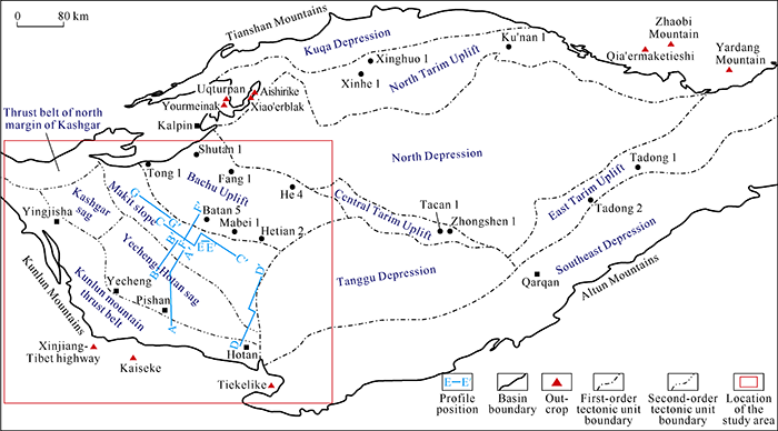
Fig. 1.
Structure outline and location of the study area in the Tarim Basin.
2. Structural features and distribution of the rift
2.1. Nanhua-Sinian sedimentary sequences in the outcrop area
The Nanhua-Sinian Systems are 2700 m thick in the outcrop area at the north slope of the Kunlun Mountains, and include the Yalaguz, Bolong, Kelixi, Yutang, Khulchak, and Kezisuhumu Formations from the bottom up (Fig. 2)[12]. Nanhua-Sinian sedimentation experienced 5 phases in 3 stages. (1) The stage of rift sedimentation includes 3 phases. Basal conglomerate of alluvial facies in the Yalaguz Formation and lacustrine deposits and dual-peak rhythmic layers of eruptive facies in the Bolong Formation as Phase 1, which corresponds to the early rift growth. Thick tillite in the Bolong Formation and littoral-neritic sandstone in the Kelixi Formation deposited as Phase 2, which corresponds to the peak of rift growth. Littoral tillite in the Yutang Formation and dolomite at the bottom of the Sinian Khulchak Formation developed as Phase 3, which corresponds to the rift shrinkage. Sediments in the 3 phases are all normal cycles with coarse grain changing into fine grain and lowstand systems tract changing into marine (lacustrine) transgressive systems tract. (2) At the stage of rift-subsidence transfer, greyish black mudstone of abyssal shelf facies in the lower and middle Khulchak Formation, and thin interbedded littoral-neritic sandy siltstone and shale in the upper Khulchak Formation deposited. (3) At the stage of filling in the depression basin, sandstone of littoral facies in the lower Kezisuhumu Formation and crystal powder dolomite of tidal-flat facies in the upper Kezisuhumu Formation deposited. In short, the basin in the Nanhua-Sinian Periods experienced a sedimentary process from continental facies to marine facies and from rift to depression.
Fig. 2.

Fig. 2.
Stratigraphic column of Nanhua-Sinian Systems in the southwestern Tarim Basin[13].
2.2. Seismic responses and structural patterns of Nanhua-Sinian Systems in the basin area
As per seismic data calibrated by wells encountering the Precambrian drilled at the south margin of the Bachu Uplift and inside the basin (Fig. 3), Paleoproterozoic granite in Well Zhongshen1 shows chaotic reflections. Nanhua varicolored conglomerate in Well Batan5 shows middle to weak layered reflections with moderate continuity. The Lower Sinian Series in Well Tong1 is composed of littoral sandstone and volcanic rocks with intrusive diabase and phyllitic epimetamorphic rock interbeds, and features discontinuous layered reflections with middle amplitude on seismic data. The Nanhua varicolored conglomerate and Lower Sinian littoral sandstone and volcanic rocks with intrusive diabase and phyllitic epimetamorphic rock have reflection configurations greatly different from chaotic reflections of the underlying Paleoproterozoic granite. Paleoproterozoic biotite K-feldspar paraschist in Well Mabei1 shows continuous layered reflections with moderate to strong amplitude. In summary, the Nanhua-Sinian sedimentary formations exhibit layered reflections, which are widely different from seismic facies of the granite crystalline basement. Paleoproterozoic paraschist also shows layered reflections, but are different from Nanhua-Sinian reflections in the following aspects: (1) Paraschist and overlying Middle Cambrian gypsum and salt rock formations exhibit similar reflection configuration, form, and frequency; this may be related to the interference of multiple reflections caused by intense absorption of seismic energy by the gypsum and salt rock formations. Nanhua-Sinian formations exhibit distinctive reflection configuration and form, which are different from overlying formation reflections; besides, Nanhua-Sinian reflections show higher frequency than the reflections of the Middle Cambrian gypsum and salt rock formations. (2) Paraschist shows laterally continuous layered reflections, while Nanhua-Sinian reflections are less continuous due to the existence of normal faults and thickness variations.
Fig. 3.
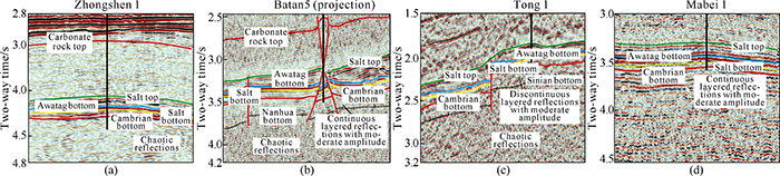
Fig. 3.
Horizons on seismic profile calibrated by wells penetrating the Cambrian System.
We establish seismic reflection patterns of Nanhua-Sinian formations in the southwestern Tarim Basin (Fig. 4) based on the differences in seismic facies between Nanhua-Sinian sedimentary formations and Precambrian granite and metamorphic crystalline basement as well as structural features in different periods. (1) The Nanhua System has normal faults controlling rift sedimentation. Where the hanging wall of the fault drops to form graben, and where the footwall of the fault rises to form horst. In the rift, Nanhua formations appear as continuous layered reflections, separated from external chaotic reflections of crystalline basement by the boundary normal faults. (2) Sinian formations exhibit continuous layered parallel reflections, have slightly extensional normal faults locally with weaker control on sedimentation than normal faults in the Nanhua System, and relatively homogenous thickness. (3) Some normal faults, which are synsedimentary, in the Nanhua System extend upward to the Middle Cambrian Series, but generally small in fault throw in the Middle and Lower Cambrian Series. This means that the normal faults in the Nanhua System tended to be active consistently in the slightly extensional tectonic setting in the Early and Middle Cambrian Epochs. In general, the Nanhua-Sinian Systems in the southwestern Tarim Basin show the structural feature of lower rift and upper depression, which correspond to the sedimentary sequences of “Nanhua rift, Early Sinian rift-depression transfer, and Late Sinian depression” in the outcrop area in the Xinjiang-Tibet Highway.
Fig. 4.

Fig. 4.
Nanhua-Sinian Systems in seismic sections across the Southwest Tarim Depression (see
(a) Section AA' in the north-south direction across the middle part of the Southwest Tarim Depression, 2D seismic line, pre-stack time migration; (b) Section BB' in the north-south direction across the middle part of the Southwest Tarim Depression, 2D seismic line, pre-stack time migration; (c) Section CC' in the east-west direction across the middle part of the Makit slope, 2D seismic line, pre-stack time migration; (d) Section DD' in the north-south direction across the east part of the Southwest Tarim Depression, 2D seismic line, pre-stack time migration; (e) Section EE' across Luonan in the middle part of the Makit slope, 3D seismic line, pre-stack time migration; (f) Section FF' in the north-south direction across the middle part of the Makit slope, 2D seismic line, pre-stack time migration; (g) Section GG' in the east-west direction across the west part of the Makit slope, 2D seismic line, pre-stack time migration.
Two rift centers in the Nanhua System, i.e. the piedmont sag and Makit slope, have been identified in the north-south AA' seismic section across the middle part of the Southwest Tarim Depression (Fig. 4a). In the piedmont sag, the Nanhua System shows a half-graben structure, i.e. the Nanhua sedimentary formations are separated from the crystalline basement in the north by the boundary fault; the Sinian System overlying the Nanhua rift appears as a wedge thinning toward the north. The reflection time of the Nanhua-Sinian Systems is 0.9 s, which means the Nanhua-Sinian Systems are 2700 m thick if the seismic wave velocity is 6000 m/s on the average. This thickness is consistent with the thickness revealed by the outcrop. In the Makit slope, the Nanhua System has 3 normal faults of similar occurrence which descend toward the north in their hanging walls in turn to form a stepwise fault complex; while Sinian formation thickens gradually toward the north. The Nanhua-Sinian formations in the rift depocenter of the Makit slope are 1500 m thick, only half of the thickness in the piedmont sag. BB' seismic section adjacent to AA' section shows the Nanhua rift has several normal faults (Fig. 4b), but no boundary faults were seen, indicating that this section may be along the rift axis.
The east-west section across the middle part of the Makit slope (Fig. 4c) shows that the Nanhua-Sinian Systems consist of 3 grabens, forming complicated graben-horst structure with surrounding horsts. Affected by normal faults in the rift, the bottom of the Nanhua System is rugged; layered reflections of the Nanhua System can be distinguished from chaotic reflections of the underlying basement roughly on 2D seismic sections. The 3D data corresponding to section CC' shows distinctive Nanhua reflections from the underlying basement reflections (Fig. 4e), and it also can be seen that the Nanhua System overlaps the basement, leveling up the terrain. In the north-south section across the middle part of the slope, the Nanhua System exhibits a stepwise graben structure (Fig. 4f), in other words, the depocenter of the rift lies in deep part of the slope and the rift margin occurs at the north margin of the slope. A fault-terrace zone, similar to that in the east faulted basin, turns up from the rift center to rift margin.
Section DD' in the north-south direction across the east part of the Southwest Tarim Depression shows a rift in the Nanhua System on the south of Well Yubei1 (Fig. 4d) is bounded by a north boundary fault and a south boundary fault, forming a symmetrical graben. On the section, the half-graben of the Nanhua System underlies the wedge body of the Sinian System in the piedmont sag, showing the same structural features as section AA'.
2.3. Rift distribution
At the north slope of the West Kunlun Mountains, the Nanhua-Sinian formations crop out from the Xinjiang-Tibet Highway in the northwest to Tiekelike in the southeast[12], indicating the Nanhua-Sinian rift is stably distributed in this area. As shown by seismic sections, the Nanhua-Sinian rift is distributed widely in the piedmont sag in the vicinity of the outcrop area. In the piedmont sag, the distribution of Nanhua formations is dominated by boundary normal faults, and the border of the Sinian wedge set lies 20 km north from the boundary normal fault of the Nanhua System. Thus, it is inferred that Nanhua-Sinian formations in the piedmont sag and outcrop area belong to the same rift which extends along Yecheng-Pishan-Hotan in nearly east-west direction (Fig. 5).
Fig. 5.
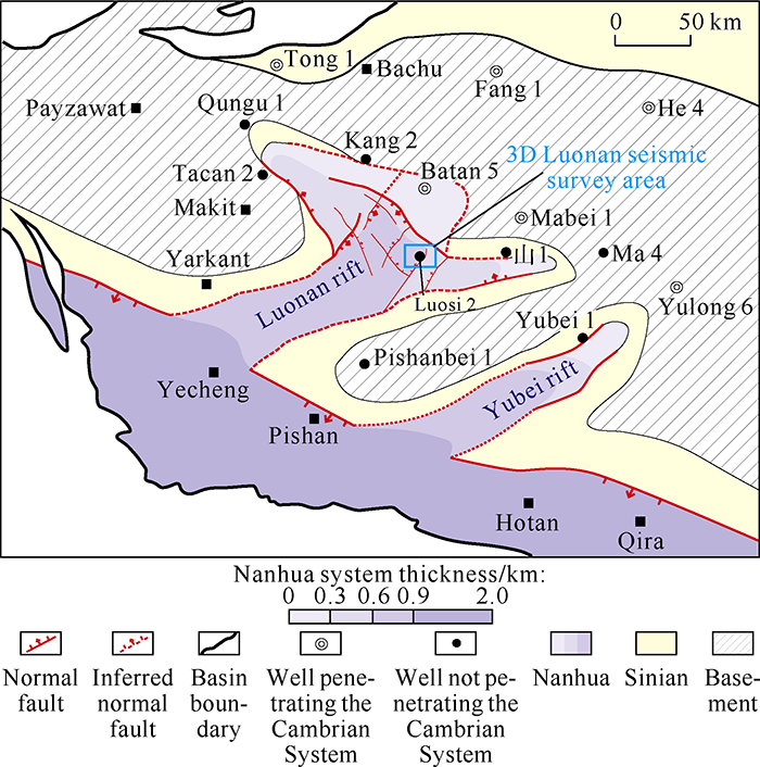
Fig. 5.
Distribution of Neoproterozoic strata in the Southwest Tarim Depression.
There are 2 Nanhua-Sinian rifts extending in northeast direction at the Makit slope (Fig. 5): one in the middle part of the slope is named the Luonan rift in this paper, and the other in Yubei in the east part of the slope is named the Yubei rift. As mentioned above, there are 3 grabens in the Luonan rift. Among them, the graben in the west of Well Luosi2 extending in northeast direction is the largest one, and is the main rift, where the Nanhua System is 800-1200 m thick and 30-50 km wide. The west branch rift lies to the west of this main rift, the boundary of the branch rift is in Tacan2 well block in the west part of the slope, as shown in sections CC' and GG' in Fig. 2. Another graben extending in NEE direction lies to the east of the main rift, the east boundary of which is 20 km south from Well Shan1. In this graben, the boundary fault of the Nanhua System can be clearly identified. Sinian formations extend in a wider area and aren’t significantly controlled by this boundary fault. The north boundary of the Luonan rift cannot be clearly identified (Fig. 4f) due to late intense tectonic movements at the north margin of the slope. From the data of wells penetrating the Cambrian System, Nanhua-Sinian formations are not developed in the Bachu Uplift; so the north boundary of the Luonan rift may be at the north margin of the slope. In general, the Luonan rift is larger with an area of 1.6×10⁴ km2, more complicated in form, and has two branch rifts. The Yubei rift is smaller with a limited area of 0.6×10⁴ km2.
2.4. Relationship between rift distribution and aeromagnetic anomalies
Aeromagnetic data works well in identifying the basal structure and buried rifts in the basin area[1]. But aeromagnetic anomalies are the stacked responses of deep-seated, shallow, and neighboring magnetic bodies[13,14]. This means that magnetic anomalies related to tectonic and magmatic activities since the Phanerozoic Eon should be eliminated to highlight Precambrian geologic framework[1]. There are 9 aeromagnetic anomaly belts, with positive anomaly belts alternating with negative anomaly belts, extending in northeast direction in the Southwest Tarim Depression (Fig. 6a). Gradient variations between the belts are gentle, but there are some high-gradient zones in local parts. The positive anomalies range between 100 and 250 nT, and the negative anomalies range between 0 and 150 nT. Yecheng and Yulong with negative anomalies are two large negative aeromagnetic anomaly belts; the former is 230 km long and 60 km wide, and the latter is 400 km long and 50 km wide. Positive aeromagnetic anomaly belts, e.g. Pishan and Hotan, in northeast direction turn up around the negative anomaly belts.
Fig. 6.

Fig. 6.
Aeromagnetic anomaly map of the Tarim Basin
(a) overlaid with Permian volcanic-rock distribution (b) and Nanhua rift distribution (c) in the southwestern Tarim Basin.
As per previous studies, major magnetic bodies in the Tarim Basin include the Archean crystalline basement, Proterozoic crystalline basement, Nanhua-Sinian basic-ultrabasic intrusive rocks, Permian basalt, and Neogene sandstone[13,14]. Among them, Archean and Paleoproterozoic crystalline basements are composed of hypometamorphic rocks with strong magnetism, the susceptibility of them generally ranges (377-754)×105 SI and may reach 23 512.3×10⁵ SI at most[18]. The Mesoproterozoic Erathem lithology is made up of quartzite, marble, and schist with medium to weak magnetism, but local basic rocks may induce strong magnetic anomalies[13,14]. Nanhua-Sinian sedimentary rocks have weak magnetism, but may have medium to strong magnetism in local parts with basic volcanic rocks interbeds, and have an average susceptibility of (1032- 4571)×105 SI[13]. Permian basalt and Neogene sandstone are magnetic rocks with a susceptibility of (1300-3400)×105 SI and (60-130)×105 SI[14], respectively. In the Southwest Tarim Depression, Neogene sandstone is distributed stably across the whole area; Permian basalt appears as continuous layered strong reflections in wave impedance on 2D seismic sections, and is distributed stably all across area except the northwest where it pinches out due to late uplifting and denudation (Fig. 6b). The alternate positive-negative anomaly belts extending in northeast direction in the Southwest Tarim Depression aren’t related to these two packages of cap beds with consistent magnetism and small-change thickness; rather these anomalies may be related to Precambrian formations.
Wells Hetian2 and Mabei1 are two deep wells drilled in the Pishan positive anomaly belt. Drilling data of them show that the Precambrian formations are Paleoproterozoic biotite K- feldspar gneiss and finely crystalline gabbro with strong magnetism. This means that the gently elevated positive anomalies are the responses to the Paleoproterozoic crystalline basement. The Luonan and Yubei rifts identified in our study all lie in the negative aeromagnetic anomaly belts with small aeromagnetic anomalies (below 75 nT). Especially, the NE-strike main rift and the east and west branch rifts well coincide with low anomaly belts and negative anomaly belts (Fig. 6c), indicating that thick Nanhua-Sinian sedimentary rocks with weak magnetism can induce low anomalies and negative anomalies with regional linear extension.
2.5. Dynamic mechanism of rift growth
Intrusive diabase dikes in the Neoproterozoic Qingbaikouan System overlapped by the Nanhua System and basalt at the bottom of the Nanhua System discovered at the north slope of the West Kunlun Mountains show trace-element geochemical features of intraplate/intracontinental ocean island basalt (OIB), indicating they are from intraplate EMI-type (high Rb/Sr value, low Sm/Nd value, and high Th/Nd (Th/Nb) and Th/La values) asthenosphere mantle[15,16,17]. These stratigraphic records prove that the Nanhua rifts in the southwestern Tarim Basin are the product of mantle plume uplifting during plate motion in an intraplate pull-apart environment. The ages of diabase dikes and basalt are 783-802 Ma[17], representing the lower time limit of rift opening. In contrast, Kuda ophiolite discovered at the north slope of the West Kunlun Mountains belongs to a typical ophiolite suite forming in mid-ocean ridge[18,19], which denotes that Nanhua rifts at the plate south margin had evolved into an ocean in the Cambrian Period. From the shape of the rifts in the basin revealed by seismic and aeromagnetic data, Nanhua rifts extend in belt shape owing to the effect of extensional stress and are composed of the rift in a nearly east-west direction in the piedmont sag and rifts in northeast direction at the Makit slope. Geometrically, Nanhua rifts show a resemblance to the three-armed rift system described in the conventional theory of plate tectonics. The piedmont zone is the rift in the three-armed rift system which evolves into an ocean, while the Luonan and Yubei rifts at the Makit slope covered by Cambrian carbonate platforms show features of withered rifts.
3. Evolution of prototype basin
The southwestern Tarim Basin had evolved into a depressed craton basin in the Cambrian Period. To investigate the evolution process of Nanhua-Cambrian prototype basin, we reconstruct the lithofacies paleogeography of the southwestern Tarim Basin at the different stages in the Nanhua-Cambrian Periods by using abundant 2D seismic data and limited geologic data (Fig. 7). The results show that the southwestern Tarim Basin experienced 3 evolutionary stages, i.e. rifting in the Nanhua Period, passive continental margin at the beginning of the Sinian Period, and stable passive continental margin in the Cambrian Period, and the early rifting has a great impact on the late craton basin.
Fig. 7.
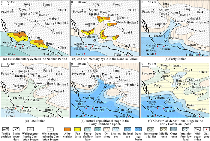
Fig. 7.
Lithofacies paleogeographic maps of the Southwest Tarim Depression at key periods between the Nanhua Period to Early Cambrian Epoch.
3.1. Rift growth in the Nanhua Period
The Rodinia supercontinent breakup led to the formation of rift system at the margin of and inside the Southwest Tarim Craton. In this stage, small belt-like multi-branch rift basins turned up, and basement land form and syndepositional normal fault activities gave rise to the structures of grabens and horsts. As observed in the outcrop area at the north slope of the West Kunlun Mountains, the Nanhua rift in the piedmont sag received continental alluvial fan and lake basin deposits at the early stage (Fig. 7a), thick tillite and sandy mudstone of neritic shelf facies at the peak of rift growth (Fig. 7b), and littoral tillite at the stage of rift shrinkage. Seismic sections crossing the piedmont sag show there are 3 sets of seismic reflections with wide seismic facies differences in the rift, which are weak, strong and weak (Fig. 4a), and correspond to 3 sedimentary cycles in the Nanhua System in the outcrop area. In contrast, at the Makit slope, the Nanhua System is only half the thickness of that in the piedmont sag, and has only two sedimentary cycles observed on seismic sections. This may be the result of the long-term sustained episodic tensional rifting in the Nanhua Period. In other words, the 3 sedimentary cycles correspond to 3 episodes of tensional rifting, the tensional rifting of episode 1 took place at the plate margin of the piedmont sag (Fig. 7a). Tensional rifting of episode 2 extended to the internal of the plate to form the rift extending northeast (Fig. 7b). Episode 3 inherited the sustained tensional rifting of episode 2. According to the process of tensional rifting in the Nanhua Period and relationship between the withered rift and south plate margin, it is inferred that Nanhua rifts at the Makit slope are mainly filled with transitional deposits (Fig. 7b).
3.2. Passive continental margin growth in the early Sinian Period
The rift basin evolved into a depressed basin at this stage. There is a sedimentary layer marking the end of rifting, i.e. the cap dolomite of 7-10 m thick at the bottom of the Sinian Khulchak Formation[12] overlapping the littoral-neritic sandstone in the Nanhua Yutang Formation at a low angle. Seismic data acquired in the basin area also show normal faults which dominated sedimentation in the Sinian System weakened in activity strength (Fig. 4), and the graben-horst structure in the Nanhua Period turned into the uplift-depression structure in the Sinian Period. In this period, the sedimentary basin expanded gradually, and the relatively isolated three-armed rifts in the Nanhua Period merged to form a uniform continental shelf. The piedmont sag evolved into the middle-outer shelf extending to the open sea, and the Luonan and Yubei withered rifts in the Nanhua Period evolved into inner continental shelf extending in tonguing to the craton (Fig. 7c). In the outcrop area, a package of 100 m thick greyish black mud shale of abyssal shelf facies can be seen at the bottom of the Sinian System, indicating a large-scale transgression happened at the early Sinian Period. Then as the water body turned shallow, extensive littoral-neritic sandstone and tidal-flat dolomite deposited in this area (Fig. 7d). This means that the southwest margin of the plate expanded into a shallow sea or deep sea, instead of an ocean basin, in the Sinian Period.
3.3. Stable passive continental margin growth in the Cambrian Period
After regional tectonic uplifting at the end of the Sinian Period, the basin evolved into a mature passive continental margin along with ocean basin spreading and extensive transgression at the southwest plate margin. Inherited from Nanhua- Sinian rifts extending in nearly east-west direction, the piedmont zone of the Kunlun Mountains was a cratonic marginal depression in the Cambrian Period. The north-south seismic section across the piedmont sag reveals craton marginal facies in the Early Paleozoic. The seismic section in Fig. 8 shows that Lower Cambrian, Middle Cambrian, Upper Cambrian, Lower Ordovician Penglaiba, Middle-Lower Ordovician Yingshan formations all thinning from north to south. The Lower Cambrian Series thins smoothly and has no obvious slope breaks. A downlap progradation complex turns up from north to south in the area with decreased formation thickness. This represents the transition zone at the slope from shallow-water carbonate deposits to deep basin. Middle Cambrian-Middle Ordovician formations have slope break zones due to abrupt decrease in formation thickness, and foreset reflections can be observed at the lower part of the slope break zones. Dome- shaped chaotic reflections with small amplitude can be seen close to the platform, which are the features of weakly rimmed platform margin. According to above structural features, the passive continental margin was a clastic-carbonate ramp in the Early Cambrian Epoch; the flat platform and platform margin formed gradually till the Middle Cambrian Epoch.
Fig. 8.

Fig. 8.
Nanhua-Ordovician in a north-south seismic section across the middle part of the Southwest Tarim Depression
(a) and geologic framework section (b) (section position shown in
At the Makit slope, the sedimentary framework in the Early Cambrian intra-craton depression was dominated by inherited evolution of the withered rift. The east-west seismic section across the Makit slope (Fig. 9) shows the Lower Cambrian Series overlaps and thins from the middle part toward the east and west to form a framework thicker in the middle and thinner at both sides. This indicates that an intra-platform sag occurred at the middle slope in the Early Cambrian Epoch. This sag and two paleohighs in the east and west constitute a paleogeographic framework of one sag sandwiched between two uplifts. The Early Cambrian intra-platform sag at the middle slope geographically coincides with the Luonan rift in the Nanhua System; this implies that this Early Cambrian carbonate intra-platform sag inherited from the depocenter of the Nanhua withered rift, while the paleohighs at both sides of the Early Cambrian intra-platform sag turned up on the Precambrian crystalline basement.
Fig. 9.

Fig. 9.
Nanhua-Middle Cambrian seismic interpretation on an east-west section across the Makit slope
(a) and geologic framework section (b) (the section position is shown in
In general, the southwestern Tarim Basin experienced an evolutionary process from rift to depression, intracontinental rift, and finally passive continental margin in the Nanhua- Cambrian Periods. In this process, as the local pulling-apart weakens, the ancient land form became subdued, the sedimentary basin expanded in scope gradually, this process is like filling and leveling up. The Nanhua-Lower Cambrian basin was a complete package of tectonic cycle because its evolution was dominated by continent breakup and ocean basin spreading. The whole basin did not change significantly in structural framework although experiencing regional tectonic movements at the end of the Nanhua Period and the end of the Sinian Period. The depocenters of the Nanhua rifts in the piedmont sag and Makit slope all show some inherited features in the late Sinian Period-Early Cambrian Epoch.
4. Significance in petroleum geology
4.1. Control of rift and post-rift evolution on Precambrian-Cambrian source centers
The three sedimentary cycles caused by 3 episodes of tensional rifting in the Nanhua Period in the southwestern Tarim Basin are all normal cycles from lowstand systems tract to marine (lacustrine) transgressive systems tract. Mud shales deposited in the Bolong, Kelixi, and Yutang Formations at the top of the 3 cycles. Mud shale of Kelixi and Yutang Formations are dark mud shale forming in the extensive transgression after the ice age. Previous studies on Neoproterozoic source- rock environments in the Yangtze Craton[20] show extensive transgression after the global ice age is favorable for the deposition of organic-rich shale. Two periods of glacial deposition in the Nanhua Period in the southwestern Tarim Basin were consistent with those in northern Tarim, Middle and Upper Yangtze, and the world. The mud shale of Kelixi and Yutang Formations are the deposits after the Sturtian ice age (680- 715 Ma ago) and Marinoan ice age (635-660 Ma ago) respectively, and may be potentially high-grade source rocks. Limited by natural conditions at the north slope of the West Kunlun Mountains, source-rock indexes of the two sets of dark mud shale in the Nanhua System in the outcrop area haven’t been obtained yet; but we can't exclude the possibility that there are potential source rocks in Nanhua rifts, southwestern Tarim Basin.
The southwestern Tarim Basin experienced two times of regional transgression at the stage of post-rift passive continental margin. The first transgression with small scale occurring at the beginning of the Sinian Period gave birth to the dark mud shale of abyssal shelf facies in the Khulchak Formation. The second transgression occurring at the beginning of the Cambrian Period was a global transgressive anoxic event[21,22], which gave birth to the dark mud shale of abyssal shelf facies in the Yurtusi Formation. These two sets of mud shale turned up in the sedimentary sags related to filling and leveling up at the post-rift stage, and the mud shale distribution is strongly controlled by the depocenters in Nanhua rifts. In other words, there is no mud shale depositing in uplifted zones of Precambrian basement, where only tidal-flat dolomite and littoral-neritic sandstone turn up. Khulchak mud shale of abyssal shelf facies (Fig. 7c) and Yurtusi mud shale of abyssal shelf facies (Fig. 7e) above Nanhua rifts are mainly distributed in the piedmont sag and the middle part of the Makit slope, and on the south of Wells Qungu1, Shan1, and Yubei1 drilled in the east part of the slope.
4.2. Upper Sinian and Lower Cambrian dolomite reservoirs controlled by post-rift evolution
There are two sets of dolomite reservoirs, one in Upper Sinian Kezisuhumu Formation and the other in Lower Cambrian Xiao'erblak Formation, in the southwestern Tarim Basin. The reservoir growth was controlled by depressed basin evolution with depocenters developing successively at the post-rift stage.
The Upper Sinian dolomite reservoirs turned up in the inner shelf epicontinental marine environment in the Late Sinian Epoch, representing by a set of tidal-flat microbial dolomite widely depositing in the piedmont sag and Makit slope[23]. Regional unconformable surface forming at the end of the Sinian Period provided conditions for karstification of dolomite weathering crust in the Upper Sinian Series. Favorable facies together with karstification results in extensive distribution of this set of reservoir in the areas with residual Upper Sinian dolomite.
The Lower Cambrian Xiao'erblak dolomite reservoirs developed in carbonate ramp-type platform environment[23]. The Xiao’erblak Formation is outer ramp deep-water deposit in the piedmont sag, and inner-middle ramp deposit in the Makit slope, both have dolomite mounds and banks. The distribution of inner- middle ramp facies in the Xiao'erblak Formation is clearly dominated by Precambrian paleostructures (Fig. 7f). Precambrian basement paleohighs controlled distribution of inner ramp in the Xiao'erblak Formation, and intra-platform low lands at the middle ramp in the Xiao'erblak Formation turned up in the centers of Nanhua rifts. Middle-ramp mounds and banks deposited at both sides of the intra-platform low lands (Fig. 9).
4.3. Source-reservoir-caprock assemblages at the post-rift stage
Confirmed Nanhua-Cambrian source rocks and reservoir rocks in the southwestern Tarim Basin were mostly formed in the development stage of passive continental margin after rifting. The two major sets of source rocks, one at the bottom of the Sinian System and the other at the bottom of the Cambrian System, and two sets of dolomite reservoirs, one in the Upper Sinian Kezisuhumu Formation and the other in the Lower Cambrian Xiao'erblak Formation, constitute two source below reservoir assemblages in the Sinian System and the Lower Cambrian Series (Fig. 9). Both the assemblages have good caprock conditions. The Yurtusi mud shale at the bottom of the Cambrian System overlies the Upper Sinian dolomite, and Middle Cambrian gypsum-salt rocks overlie Lower Cambrian Xiao'erblak Formation dolomite. The caprock of the Middle Cambrian Series has better sealing property.
The Cambrian sub-salt dolomite and Upper Sinian dolomite in the southwestern Tarim Basin have large burial depths of over 7000 m in general. In view of buried depth and hydrocarbon accumulation conditions, the middle part of the Makit slope is the most promising and realistic zone for Cambrian sub-salt and Upper Sinian dolomite exploration. This is because: (1) There are in-situ source rocks in the Cambrian Yurtusi Formation and Sinian Khulchak Formation (Fig. 9). (2) Mounds and banks occur at both sides of intra-platform low lands in the Lower Cambrian Xiao'erblak Formation, and the Upper Sinian Series has a high possibility to have high-grade dolomite reservoirs as the seismic facies of Upper Sinian dolomite and the unconformable surface at its top are clear and reliable (Fig. 4c). (3) This area lies in the seesaw-like hinge zone of structural adjustment, which is favorable for hydrocarbon migration and preservation. (4) The Cambrian sub-salt dolomite is buried at a relatively shallower depth of less than 8500 m. Seismic survey in the middle part of the Makit slope should be strengthened in the next step of exploration to confirm Cambrian sub-salt and Sinian dolomite reservoirs to seek hydrocarbon discoveries.
5. Conclusions
The Rodinia Supercontinent breakup in the Neoproterozoic Era gave birth to the Nanhua rift system at the margin of and inside the Southwest Tarim Craton. In the piedmont sag in the basin area, the Nanhua rift in half graben shape extends in nearly east-west direction. At the Makit slope, the Luonan and Yubei rifts in northeast direction developed in the Nanhua Period. The Luonan rift in the middle part of the slope had a west branch extending in northwest direction and an east branch extending in nearly east-west direction. The rift system consisted of several horsts and grabens, forming a complex graben-horst structure. The rift in nearly east-west direction in the piedmont sag and the rifts in northeast direction at the Makit slope constitute a three-armed rift system described in the theory of plate tectonics.
The Neoproterozoic-Cambrian prototype basin in the southwestern Tarim Basin experienced 3 evolutionary stages, i.e. rifting in the Nanhua Period, passive continental margin at the beginning of the Sinian Period, and stable passive continental margin in the Cambrian Period. The depocenters forming at the rifting stage in the Nanhua Period showed successive development at the depression stage from the Sinian Period to the Early Cambrian Epoch. Nanhua rifts in the piedmont zone of the Kunlun Mountains evolved into a cratonic margin depression from the Sinian Period to the Eopaleozoic Era, and the Luonan withered rift at the Makit slope evolved into an intra-platform sag in the Early Cambrian Epoch. This sag and two paleohighs in the east part and west part of the slope constituted a paleogeographic framework of one sag sandwiched between two uplifts.
Prototype basin evolution with inherited depocenters at the post-rift stage in the Sinian-Cambrian Periods in the southwestern Tarim Basin dominated the distribution of two major sets of source rocks, one at the bottom of the Sinian System and the other at the bottom of the Cambrian System, and two sets of dolomite reservoirs, one in the Upper Sinian Series and the other in the Lower Cambrian Series, and the source rocks and reservoirs constitute two source rock-below-reservoir assemblages in the Sinian System and Lower Cambrian Series. The middle part of the Makit slope is the major zone for the next step exploration of Cambrian sub-salt and Sinian dolomite reservoirs in this area.
Reference
Distribution and petroleum prospect of Precambrian rifts in the main cratons, China
Theoretical and technical innovations in strategic discovery of a giant gas field in Cambrian Longwangmiao Formation of central Sichuan paleo-uplift, Sichuan Basin
Formation, distribution, resource potential and discovery of the Sinian- Cambrian giant gas field, Sichuan Basin, SW China
Basic geological characteristics and accumulation conditions of Anyue giant gas field, Sichuan Basin
The north-south differentiation characteristic and its enlightenment on oil-gas exploration of the Neoproterozoic rift basin, Tarim Basin
The paleogeographic framework and hydrocarbon exploration potential of Neoproterozoic rift basin in northern Tarim Basin
The characteristics of Precambrian sedimentary basin and the distribution of deep source rock: A case study of Tarim Basin in Neoproterozoic and source rocks in Early Cambrian, Western China
The style of sequence stratigraphy of Neoproterozoic rift basin in the Tarim Basin
Nanhua- Sinian rift distribution and its relationship with the development of Lower Cambrian source rocks in the southwest depression of Tarim Basin
The opening-closing of surrounding ocean basin in response to tectonic-sedimentation in Tarim Basin
The Sinian at slope western Kunlun Mountians
Analysis of regional magnetic field and source structure in Tarim Basin
Distribution characteristics of permian igneous rock in Tarim Basin: Based on the high-precision aeromagnetic data
DOI:10.6038/pg20140448
URL
[Cited within: 4]

Based on 1:200 thousand high-precision aeromagnetic data, upward continuation and the residual anomaly are used to analyze the the relationship between the aeromagnetic anomaly and lithologic body in tarim basin. The Permian igneous rock is closely related to basement fault after the identification of basement faults, igneous rock nearby the basement faults is moniliform and homo-conical in the aeromagnetic anomaly map. Combined with the seismic and drilling data, the Permian igneous rocks in the Tarim Basin can be divided into four zones: intermediate-acid intrusive rock of northern area, basic volcano rock of middle-western area, intermediate-acid volcano rock of southern area and intermediate-acid volcano rock of northeast area,and the igneous rock is closely related to plate tectonic movement.
Zircon SHRIMP age of Neoproterozoic gneissoid granites in the West Kunlun and its significance
Depositional types of lower part of Nanhua System on the northern margin of southwest Tarim and their tectonic significance
Geochemistry characteristics of the Proterozoic meta-basalt in southern Tarim Plate: Evidence for the Meso-Proterozoic breakup of Palco-Tarim Plate
A further discussion of the kuda opiolite, west Kunlun, and its tectonic significance
The geological characteristics and formation epoch of west Kunlun Kudi Petrofabric
Hydrocarbon generation characteristics and exploration prospects of Proterozoic source rocks in China
DOI:10.1007/s11430-018-9312-4 URL [Cited within: 1]
Early-Middle Cambrian paleogeography and depositional evolution of Tarim Basin
Sedimentary facies research and implications to advantaged exploration regions on lower Cambrian Source Rocks, Tarim Basin
DOI:10.11764/j.issn.1672-1926.2015.07.1224
URL
[Cited within: 1]
In recent years,large amount of hydrocarbon reserves have been discovered in the Tarim Basin.However,selection of advantaged exploration regions becomes more and more difficult because of poor knowledge of the distribution of source rocks.In this paper,outcrop profiles,drilling cores,and seismic materials were studied.The results show mild slope sedimentary models are more suitable for Yu′ertusi Formation,and source rocks mainly distribute in middle-lower mild slope and deep water shelf facies.Based on materials points and seismic profile studies,two sets of source rocks were distinguished: one lies in the northern depression,the other distributes in the south edge of southwestern depression.Distribution of source rocks in the study area coincide with discovered hydrocarbon reserves,providing new evidence for major source rocks.Meanwhile,the distributions of paleo-uplifts were considered.Three exploration regions of Manxi Lower Uplifts,Badong areas,and southwestern depression have been regarded as the most advantaged regions.
Sedimentary characteristics and lithofacies paleogeography of Sinian in Tarim Basin
