


Introduction
In oblique subduction zones, strain partitioning occurs between displacement in the subduction megathrust perpendicular to the trench and strike-slip motion parallel to the trench[1-2]. This partitioning plays an important role in the formation and development of the forearc area[3-4]. Along the oblique Sumatra subduction zone, the trench- parallel slip is accommodated by the Sumatran Fault (SF) zone, which become the boundary of the sliver plates[1]. Furthermore, major shear zones of Mentawai Fault (MF) and West Andaman Fault (WAF) have been proposed to have separated the forearc basin from the forearc highs, which are occupied by uplifted accretionary wedge complexes[5⇓⇓-8]. However, recent data from the Andaman and Sumatra forearc indicate that even though a subduction obliquity occurs at this convergent margin, the forearc highs are bounded by compressional structures with slight strike-slip motion[9⇓⇓-12]. Furthermore, previous studies of the Sumatra forearc indicate that the deformation in the forearc high zones also includes flexural uplift, basin inversion and uplift of older accreted sediments[12⇓-14]. This paper reviews several growth mechanisms of the Sumatran forearc highs and formation of the forearc basin related to the oblique subduction system.
1. Geological background
The Indo-Australian Plate subducts obliquely beneath the western Sunda Arc at a rate of 43-60 mm/yr, forming strain partitioning between displacement in the subduction megathrust and the trench-parallel movement along the SF[1,15⇓ -17] (Fig. 1). In this oblique subduction zone, several large earthquakes have been recorded along the forearc area[18-19]. From Simeulue Island in the northwest of Sumatra to Enggano Island in the southeast (Fig. 1), some of the forearc highs are exposed above sea level. Farther north, the Andaman-Nicobar islands make up the northern extension of the forearc high zone. To the east, forearc high is observed in the south of Java and Lesser Sunda islands.
Fig. 1.

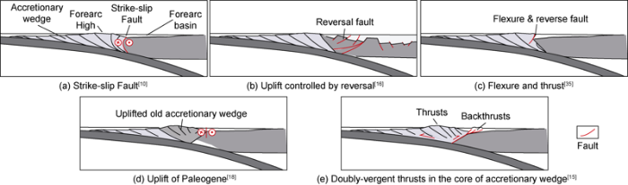
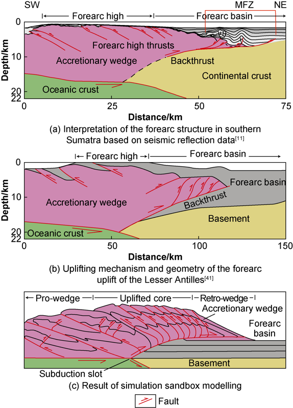
The origin of the Sumatran forearc high have been interpreted due to the uplift of accretionary wedge complex in relation with strike-slip displacements due to strain partitioning[7,20 -21], inversion-controlled uplift[12], homoclinal flexure and reverse fault[13,22 -23], uplift of the Paleogene accretionary wedge[14], and arcward-vergent backthrusts[9,11,24] (Fig. 2). The development of the Sumatran accretionary wedge complex is due to the incorporation of Sunda trench sediments[14,25]. The structures developed in the forearc highs are interpreted as thrust or inverted normal faults[11-12,14,23] and shear zones[6,20]. The exposed rocks on the forearc highs are of sedimentary origin and the basement rocks are a mixture of continental and oceanic materials[12-13,23].
Fig. 2.
In the eastern part of the forearc high, the Paleogene basins formed as localized depocenters enclosed by north-trending faults, which are related to transtensional setting between two major strike-slip faults, the WAF-MF and SF[26⇓-28]. The SF zone extends along the Sumatra Island and merges with another major strike-slip fault zone, the WAF[30]. At the southeastern end of the SF the Semangko pull-apart basin developed between Sumatra and Java[17,31].
Based on observation of seismic data, shear zones occupied the landward margin of the Sumatran forearc highs[5,7 -8,20]. However, previous observations on this forearc high margin zone suggest a flexure or inverted normal fault stretches in this area[12,22 -23]. Based on analysis of high-resolution seismic reflection data, an arcward-vergent backthrust developed in the landward margin of the Sumatran accretionary wedge[9,11,24] that continued at depth to the continental backstop[11,32].
2. Geological characteristics of Sumatran forearc
2.1. Strain partitioning, sliver plates, and shear zones
Strain partitioning in the Sumatran forearc divides the trench-perpendicular motion in the subduction megathrust and trench-parallel slip along the SF[1]. The SF zone stretches more than 1700 km along the axis of the island mainly with 20 fault segments[15]. These fault segments, which range from 60 to 200 km in length, have ruptured historical earthquakes between M6.5 to M7.7[33]. In its most southeastern part, the SF exhibits a pull-apart basin due to over stepping between a segment of the SF and the Ujung Kulon fault (UKF), another shear zone south of Java Island[7,17].
In the Sumatra subduction system, this concept of strain partitioning has been expanded, that another deformation zone parallel to the trench occurs in the area between the SF and the trench referred to as MF (Fig. 1)[5]. In the western boundary of the forearc basin from Nias to the Sunda Strait, this shear zone shows a linear feature of 600 km long, exhibiting positive flower structures on the seismic profiles[5,7]. Furthermore, the strain partitioning in Sumatra is described by a model of two sliver plates here referred to as the Mentawai and Aceh sliver blocks that host the forearc basins (Fig. 1)[7]. This model proposed that the trench-parallel strain is facilitated along three major shear zones: SF, MF, and WAF (Figs. 1 and 2a). The MF is attenuated farther north and connected to SF through the Batee Fault (BF). The accretionary wedge moves northwest along the MF. Hence, SF and MF bounded the Mentawai sliver block.
In northern Sumatra, SF and WAF bound the Aceh micro-plate. The WAF shows vertical offsets of reflectors along the western edge of the northern Sumatra forearc basins[8,20]. WAF appears to have crossed the accretionary wedge and developed farther west on the seafloor[8]. Farther south, this fault appears to have continued to a complex of anticlinal structures interpreted as Tuba Ridge[6⇓-8,20] and bounded by another shear zone developed within the forearc basin. This shear zone has been interpreted as the southern extension of the WAF[7]. Malod and Kemal[7] argued that the flexural bending of the basement of the accretionary wedge, the thrust fault of the Banyak Islands and the anticline near Simeulue indicate the strike-slip displacement activity between the sliver plate and the accretionary wedge. Fig. 3a shows an example of deformation related to strike-slip fault activity on the boundary between the forearc high and the forearc basin in northern Sumatra[8]. The faults observed on the seismic profile can be divided into five types: Faults in Group I to IV are part of the strike-slip fault that penetrates the seafloor, while the Group V fault is a thrust fault that appears as a blind fault. Here we argued that the blind thrust fault has formed earlier than the strike-slip fault.
Fig. 3.
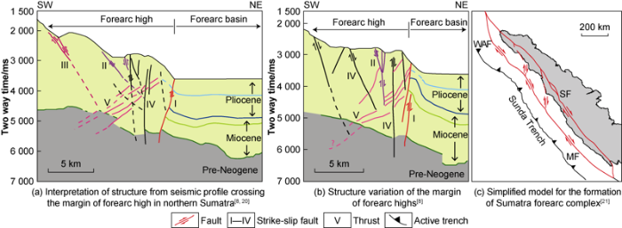
The sliver-blocks concept in the Sumatran forearc is updated by a hypothesis that large-scale strike-slip duplexes formed in the forearc basins (Fig. 3b). Based on observation of high-resolution seismic reflection data, Berglar et al.[21] identified four horses within a large duplex system related to the SF and MF zones. Each horse structure includes a single forearc basin with varied depositional patterns during the Mid/Late Miocene to Early Pliocene: the Bengkulu, Nias, Simeulue, and Aceh basins. The connecting splay faults, namely the Siberut and the Batee faults formed near Batu and Banyak islands. Furthermore, several authors argued that during Paleogene to early Neogene, a part of the strike-slip displacement was transferred in the forearc basin[25⇓⇓-28]. They proposed that the Paleogene South Sumatra forearc basin developed as a localized depression in a transtensional environment. In the northern Sumatra forearc, north-trending fault limits the development of early Neogene depocenters.
2.2. Basin inversion-controlled uplift
Uplift of the Sumatran forearc high may also have formed by inversion of the Oligocene-Early Miocene forearc basins that initially formed along the trenchward margin of the forearc (Fig. 4)[12]. Based on field observation in Nias, these authors proposed that the inverted faults formed in a northwest trend parallel to the axis of the island. These inverted faults were initially formed as normal faults that constructed several trench-parallel depocenters along the present-day forearc high axis. This basin inversion took place within two stages: the first stage was initiated in the Early Miocene, restricted in the western area of the island, while the second inversion occurred in Pliocene and involved the whole area of Nias.
Fig. 4.
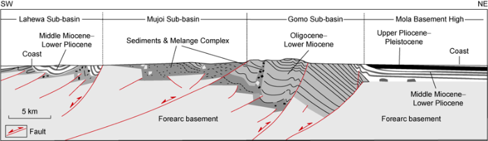
Fig. 4.
A simplified geological map across Nias Island[12] (See
Furthermore, previous study also revealed that the rocks overlying the basement of Nias Island were of Paleogene deep marine strata deposited in the former forearc basin[12]. Hence they were not part of accreted sediments from the trench. The accretionary wedge is developed farther southwest of Nias Island. The basement rocks comprise ophiolitic materials suggesting their source is related to the accretionary wedge environment.
2.3. Homoclinal flexure in the landward margin of forearc high
Large flexures have been observed in one of the forearc high islands related to a high-angle reverse fault at depth[22,23] (Fig. 5). The flexures were formed along the eastern edge of Nias Island parallel to the trench. These large flexures and arcward-vergent reverse faults appear to have developed in the arcward margin of forearc high. These reverse faults uplifted and deformed mass of the lower trench slope, which was assumed to migrate westward when the accretionary wedge widened during Neogene[13]. Based on their observation of the seismic profiles, Karig et al. suggested that the reverse faults beneath the flexure flatten at depth seem neither related to the Paleogene continental margin nor the leading edge of the trapped oceanic crust[22]. Furthermore, most displacements along the flexure in Nias occurred during a short interval in the late Pliocene, as suggested by a sharp unconformity and by the rapid inversion of paleo-bathymetry across the flexure[22]. Therefore, we can conclude that the initiation of the reverse faults postdates the growth of the trenchward-vergent imbricated thrusts in the accretionary wedge.
Fig. 5.
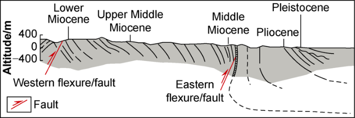
Fig. 5.
Structural interpretation of eastern Nias Island[23] (the section location is shown in
2.4. Uplift of older accretionary wedge complex
Based on seismic reflection profiles, Schluter et al. found that the accretionary wedge can be divided into two morphological segments with different deformation styles (Fig. 6)[14]. The first segment is the inner wedge (accretionary wedge I) located beneath the forearc high, and the second one is the outer wedge (accretionary wedge II) that stretches from the trenchward boundary of the inner accretionary wedge to the trench. The accretionary wedge I is characterized by 5-6 trenchward-vergent thrust faults and separated from the accretionary wedge II by a detachment. The outer wedge exhibits more complicated internal structures than the inner wedge.
Fig. 6.
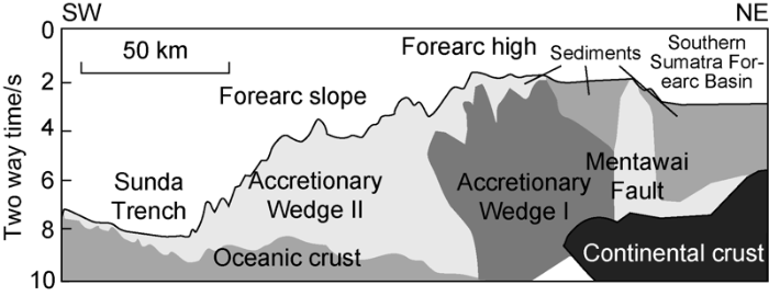
Fig. 6.
Interpretation of a seismic profile crossing the accretionary wedge in Sumatra[14].
In the early Paleogene, the subduction system formed the accretionary wedge I along the Sunda margin[14]. Due to continuous convergence, the inner wedge underwent uplift and erosion. Later on, the inner wedge was acted as a buttress against the outer wedge formed by the off scrapping of younger trench-fill sediments. The outer wedge formation initiation induced the initial uplift of the inner wedge during the middle-late Miocene. The trenchward-vergent detachment zone between the younger accreted sediments and the Paleogene wedge (accretionary wedge I) also plays a role in the initial uplift and tilting of the inner wedge. The inner wedge started to form the present-day forearc high in the early-middle Miocene.
2.5. Doubly-vergent thrusts
In the southern Sumatra forearc highs, low-angle trenchward-vergent thrust faults have been observed beneath the seafloor (Fig. 7a), here called forearc high thrusts (FHT)[11]. The flat seafloor of the forearc high that was covered by Pleistocene carbonates appears to have been tilted arcward, indicating an active deformation within the forearc high. To the east of the Enggano forearc high, arcward-vergent thrusts have been observed in the core of anticlines within the MF zone (Fig. 7a)[11]. These authors argued that in the beginning, the trench- ward-vergent thrusts might have developed as overturned anticlines that later broke as thrusts due to continuous compression in the accretionary wedge. These thrusts deformed the accretionary wedge sediments as indicated by the appearance of chaotic reflectors beneath the top of the wedge. These trenchward-vergent thrust faults appear to have continued into a deep-seated arcward-vergent backthrusts at depth beneath the forearc high that continued up dip to the thrust faults in the core of the Mentawai Fault Zone (Fig. 7a). The interplay between these two opposing direction thrust faults appears to have responsible for the forearc high uplift.
Fig. 7.
A similar pattern of trenchward-vergent thrust faults in the forearc high has been observed in the southeasternmost part of the south Sumatra forearc[14] and in the northern Sumatran forearc[9]. Northwest-trending thrust faults have also been mapped in the Sumatran forearc high islands[28,34⇓⇓ -37]. These observations show that these trenchward-vergent thrust fault belts dominated the deformation along the entire Sumatra forearc high. Whereas for the arcward-vergent thrusts along the landward boundary of the accretionary wedge, this fault zone appears to have developed close to the forearc high in the northern Sumatra forearc basins[28,30⇓⇓⇓⇓⇓⇓ -37].
In the early stage of the growth of the accretionary wedge, two reverse kink bands constrained a box fold structure that later on became two divergent structures, trenchward-vergent and arcward-vergent thrusts[11]. Similar mechanisms have been observed in analog and numerical sandbox modelings of accretionary wedge formative processes[38⇓⇓-41].
2.6. Stratigraphy and subsidence history of forearc basin
Based on the present-day bathymetry, the Sumatran forearc basin can be divided into two parts: the northern and the southern basins (Fig. 1). The northern Sumatra forearc basin refers to the depression from the northern of western Sumatra offshore to the southeast of Batu Islands. While the southern Sumatra forearc basin expands from the east of the Mentawai Islands to the south of Sunda Strait.
2.6.1. Northern Sumatra forearc basin
The northern Sumatra forearc basins include Meulaboh Basin (Sibolga Basin) and Nias Basin[42]. A 25-km-wide half-graben in this forearc basin exhibits stacks sediments with a thickness of about ~2s thick (Fig. 8)[43]. These half-grabens are mainly observed on the strike-line seismic profiles along the axis of the basin, suggesting these structures formed in a SW-NE or N-S trends. Deep seated N-S structures have been interpreted to control the distribution of Early Miocene depocenters in the northern Sumatra forearc basin[25]. Whereas the thickness of the Late Miocene and younger sediments does not change much throughout the basin (Fig. 8). Indeed, several parts of the basin show thicker stratigraphic units suggesting the depocenters position, but there is no indication of structural control to the formation of these depocenters.
Fig. 8.
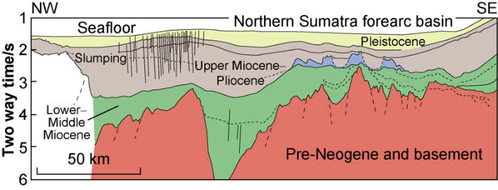
Fig. 8.
Interpretation of a seismic profile in front part of Simeulue Island along the axis northern Sumatra forearc basin[43] (The section location is in
In some areas of the northern Sumatra forearc, the opening of the basin is due to the E-W extensional tectonics related to the emerging play of SF and MF in the Miocene[43]. Beaudry and Moore interpreted a regional-scale tectonic event occurred before the deposition of the Neogene basin fills[42]. During the Pliocene-Quaternary period, the north Sumatra forearc basin was separated into Aceh and Simeulue basins by the Tuba Ridge, a compressional structure in the strike-slip fault zone[6,20].
Based on several exploration wells, the oldest Paleogene sediments in the northern Sumatra forearc consist of dolomitic limestone, calcareous mudstone, and shale of Late Eocene to Early Oligocene[27,42]. The Lower Miocene shelf sediments unconformably overlay the Paleogene strata. In middle-late Miocene, a widely distributed carbonate platform developed in the shelf area. Upper Miocene deep marine shale with rare thin sandstone or limestone bed deposited over carbonates. The Plio-Pleistocene regressive sequences consist of sandstone, shale, and limestone occupied the upper part of the basin.
Based on outcrop observation in Nias Island, Samuel et al. found that extensional tectonics occurred during Oligocene-Early Miocene[12]. The the extensional structures formed multiple NW-trending half-grabens along the axis of the forearc high. An important Early Miocene unconformity took place in the western part of Nias Island due to basin inversion. The Early - Middle Miocene period of differential uplift and subsidence terminated in Late Miocene. The subsequent unconformity took place along the entire island, indicating that a major uplift had started in the Pliocene.
2.6.2. Southern Sumatra forearc basin
In the late Eocene, the Southern Sumatra forearc basin that include the Mentawai and Bengkulu basins began to subside and became depocenters for more than 4 km Neogene sediments (Fig. 9)[26-27]. Horst and graben structures appear to have formed in the basement, controlling the deposition of the Paleogene sequences. In the upper part of the basin, the thickness of the Neogene sediments appears to be similar. Furthermore, there is no indication of structural control on the formation of the Neogene basin. The deepest part of the Neogene basin appears to have formed longitudinally along the center of the basin and parallel to the trench. This observation suggests that the subduction system plays an important role in the formation of the basin. North-South structure seems to have controlled the development of the Paleogene Bose and Sipora grabens in the Mentawai Basin[28]. Similar north-trending structures have also been interpreted from onshore gravity anomalies and seismic data in the Kedurang and Pagarjati Grabens (Bengkulu Basin)[26,44].
Fig. 9.
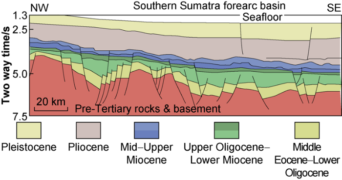
Fig. 9.
Stratigraphy and structural interpretation along southern Sumatra forearc basin[27] (The section location is in
The north-south structures developed in the basement of the southern front of the Sumatra arc may represent a regional east-west extension, which was caused by a north-south compression in Middle Eocene[45]. The northeast-southwest trend of the Late Eocene-Early Miocene graben system may also reflect the rotation of Sumatra that changed the direction of compression. This interpretation supports the previous hypothesis of the counter-clockwise rotation of the southern Sundaland[45].
The Paleogene rocks unconformably overlay the basement of the southern Sumatra forearc basin that consists of Pre-Tertiary metasediments, metamorphic, and igneous rocks[46]. The Lower Oligocene strata are of volcanic origin intercalated with fluvial and shallow marine sandstones. The Upper Oligocene-Lower Miocene sediments consist of marine siliceous clastic deposits. In the Bengkulu shelf, the Eocene-Oligocene to lower Miocene sediments formed in local depocenters of possibly pull-apart basin[26-27]. The Lower to Upper Miocene sequences consist of backstepping carbonate rocks interfingered with fine carbonaceous-tuffaceous clastics, and regressive clastic deposits. These sediments were subsequently covered by middle to upper Miocene transgressive-regressive marine sequences.
3. Discussion
3.1. Strain partitioning in the Sumatra forearc
It has been suggested that major strike-slip faults in Sumatran forearc bounded the sliver plates in between the arc and accretionary wedge (Fig. 1)[5,7,21]. However, there was a disagreement on the suggestion of the motion within the MF because the GPS data from the northern part of the Mentawai islands showed no indications of any large transverse movement[47]. In addition, a recent work using the updated geological slip rates for the SF and the latest GPS data covering Sumatra and the forearc high land show that the deformation within the Sumatra forearc sliver plates is relatively small[48]. Therefore, this observation did not show any evidence of strike-slip activity along the MF and WAF belts. In addition, there is no moderate-large earthquakes with strike-slip motion in the boundary between the forearc highland and the forearc basin (Fig. 10), Suggesting that strike-slip faults do not exist or the strike-slip motions are inactive.
Fig. 10.

Fig. 10.
Interpretation of MF along the south Sumatran forearc[11].
Reexamination of published bathymetry data showed that a strike-slip fault zone was observed in the eastern side of accretionary wedge in the northern Sumatra forearc basin[8]. However, the fault zone extends northward to WAF in the Andaman Sea within the forearc basin[10,29-30]. Furthermore, in the Andaman Sea, the boundary between the accretionary wedge and the forearc basin is actually marked by the Diligent Fault[10,29,49]. Therefore, strain partitioning indeed occurred in northern Sumatra and the Andaman forearc. However, the strike-slip fault zone did not form in the boundary between the forearc basin and accretionary wedge. This major strike-slip fault extends from the arc, passes through the forearc basin and terminates in the accretionary wedge. In the southern Sumatra forearc, the evidence for the large strike-slip deformation on the eastern edge of the accretionary wedge is less clear. However, the steeper dip of the backthrusts that deformed the Neogene forearc basin sediments may represent trench-parallel shear[11]. Nevertheless, en-echelon structure along the MF were not observed on the high-resolution bathymetric data.
In the Sumatran forearc, the trench- parallel strain in this oblique subduction system may also distributed in the form of transpressional folds and thrusts in the accretionary wedge. These structures are observed to have formed at a low angle to the strike of the trench[9]. Furthermore, the trench-parallel motion may have been largely absorbed by the strike-slip fault system within the accretionary wedge, as shown in the Sumatran forearc high islands[12,34⇓ -36].
In the Ryukyu accretionary wedge that formed by the oblique subduction of the Philippine Sea plate beneath the Ryukyu Margin, the Yaeyama Fault dissected some parts of the Ryukyu accretionary wedge. It continued further northwestward, causing strike-slip movement in the forearc basin. However, doubly-vergent backthrusts and forethrusts have been still observed in the arcward margin of the accretionary wedge[4]. A major strike-slip fault formed in the forearc basin and continued farther northwestward to the Kuril Arc along the oblique subduction in the Kuril Trench[51]. Therefore, similar to the situation observed in northern Sumatra, these observations indicate that strain partitioning in oblique subduction system induced the development strike-slip faults deforming the entire forearc. The major strike-slip fault does not necessarily play as the boundary between the forearc high and the forearc basin.
3.2. Uplift forearc high
The highest part of the uplifted accretionary wedge complex is located in the forearc high, which have been interpreted to have formed due to the MF-WAF strike-slip fault zones[5⇓⇓-8,20 -21]. However, based on field observations in the forearc high islands, strike-slip motion is minor along MF zone[12]. Furthermore, seismicity records since the early 1960s show that there are no earthquakes caused by strike-slip movement in this fault zone, indicating that there are no active strike-slip faults in this area. Recently acquired seismic tomography data do not show that any large vertical structure that may accommodate lateral movement between the accretionary wedge and the continental backstop[32,52].
Based on recently acquired seismic reflection data in the Sumatran forearc[10-11], we do not observe any evidence of inversion tectonic (e.g. the harpoon structure) beneath the forearc high. Furthermore, the previous observation of thrust beneath flexure in the forearc high in Nias[22-23] is actually supports the interpretation of backthrust in the Sumatran accretionary wedge. In addition, we do not observe any detachment or splay fault in the published seismic reflection profiles that has been argued to have controlled the uplift of older accretionary wedge sediments in the forearc high[10-11].
Recently acquired seismic tomography data revealed the geometry of trenchward-dipping continental backstop against the accretionary wedge complex[32,52]. Seismic reflection data along the Andaman and Sumatra forearc show that the backthrust developed along the backstop[9⇓-11]. The relocation of the M7 1976 earthquake and its aftershocks in the northern Sumatra forearc indicated the activity of the backthrust[50]. Furthermore, the backthrust is also considered to have ruptured at the same time as the 2004 great Sumatra earthquake[9]. This structure extended upward near the seafloor and induced folds and thrusts within the forearc basin sediments[11]. The arcward-vergent backthrust in the Sumatra forearc basin seems to be coeval with the trenchward-vergent imbricated thrusts in the forearc high, forming a doubly-vergent thrusts in the core of the accretionary wedge complex.
Based on these observations and comparisons, we argued that the development of the doubly-vergent wedge is responsible for the forearc high uplift in the oblique Sumatra subduction system (Fig. 2e). Moeremans and Singh also observed the pattern of the growth of the accretionary wedge farther north in the Andaman forearc, which exhibits more obliquity in the subduction system[10]. This observation indicates that the doubly-vergent accretionary wedge is not uncommon to have develop in an oblique subduction system. The strike-slip fault observed along the backthrust in the northern Sumatra forearc basin is the southern extension of the Andaman-Nicobar fault[49]. Furthermore, thrusting in the forearc high can explain the observation of trench-parallel reverse fault onland[34⇓⇓-37]. In other subduction zone, doubly-vergent thrusts in the accretionary wedge has also been observed including the Hellenic arc, Lesser Antilles (Fig. 7b) and the Panama Trench[53⇓-55]. Furthermore, sandbox modeling results show that thrusts and backthrusts have been uplifted the core of the accretionary wedge, and formed the forearc high in the orthogonal to moderately oblique subduction setting[40].
3.3. The growth of forearc basin
Based on the observation of seismic reflection data, the Paleogene Sumatran forearc basins developed in localized depocenters related to the graben system[26⇓-28,44], which was speculated to have formed as extension of the graben system in the Sumatra back arc basin[26,44]. The Paleogene basin may also have formed by the northeast-trending rift, which was subsequently overprinted by the pull-apart basin system between major strike-slip faults[26]. However, the Paleogene graben observed on the seismic reflection profile parallel to the axis of the basin is actually part of deep forearc basin in front of the early Neogene shelf edge[43]. Therefore, there is a variation along strike of the Paleogene forearc basin, where the shallow forearc developed near the deep portion of the basin. This observation supports similar results of Matson and Moore on the variation of local depocenters along the forearc basins[25]. This variation in the Paleogene depocenter can be controlled by normal faults traversing the basin.
The Paleogene grabens in Sumatran forearc may also related to pull-apart basin in the SF and MF systems[26⇓-28]. However, MF itself initiated in early-middle Miocene[11], while SF may have formed later in middle Miocene[31] or Pliocene[15]. Therefore, it is necessary to further study the development of these two strike-slip fault zones in detail.
The deeper portion of the Paleogene Sumatra forearc basin may have been located in the present-day forearc high area, such as Nias Island[12]. Similar conclusions can be drawn from observation on seismic reflection data in the offshore southern Sumatra. Some parts of the Paleogene strata may have been integrated into the accretionary wedge sediments[11,14]. Furthermore, the Neogene forearc basin may have extended to the present-day forearc high, as suggested by continuous deposition of the Neogene sequences from the forearc basin to the forearc highs. In the northern Sumatra forearc, deformed forearc basin strata are observed on the top of the accretionary wedge[9]. These strata are highly folded and faulted, indicating that this area has undergone a compressional tectonics. The Neogene forearc basin widely formed along the front of forearc high islands parallel to the trench.
Thicker sediments in the Sumatra Paleogene depocenters may produce higher temperature, which plays an important role in the maturation of source rocks. The discovery of oil and gas with sub-commercial value in these forearc basins indicates that there is an effective oil and gas system in the area. In the next step, a detailed study is needed to clarify the origin of the Paleogene depocenters in the Sumatran forearc basin.
4. Conclusions
Based on the review of previous studies in the Sumatran forearc area, several proposals concerning the mechanism of the forearc uplift are proposed, including major strike-slip fault zones, flexural uplifts, basin inversions, older accretionary wedge uplifts, and doubly-vergent wedge mechanics in the rear part of accretionary wedge. Although the subduction system is oblique, the deformation of the Sumatran accretionary wedge is mainly controlled by folding and thrusting due to the orthogonal component of the strain partitioning. Observation of recently acquired seismic reflection data shows that the interaction between trenchward-vergent thrusts and arcward-vergent backthrusts plays an important role in the uplift of the forearc high. The strike-slip fault appears to play a minor role in the uplift of the forearc high. Some sediments of the forearc high were formed in the previous deep forearc basin environment. The modern morphology of forearc highs and forearc basins is related to the rapid uplift of forearc high and the deformation of accretionary wedge during Pliocene. The Paleogene forearc basin seems to be formed in local depocenters. On the contrary, the trend of the Neogene forearc basin aligned parallel to the trench and developed toward the arc, indicating the subduction system played an important role in the formation of the forearc basin.
Reference
Plate convergence, transcurrent faults, and internal deformation adjacent to Souheast Asia and the western Pacific
DOI:10.1029/JB077i023p04432 URL [Cited within: 4]
Oblique plate convergence, slip vectors, and forearc deformation
DOI:10.1029/92JB00483 URL [Cited within: 1]
Strain partitioning and interplate friction in oblique subduction zones: Constraints provided by experimental modeling
DOI:10.1029/1999JB900332 URL [Cited within: 1]
Oblique subduction of the Gagua Ridge beneath the Ryukyu accretionary wedge system: Insights from marine observations and sandbox experiments
DOI:10.1023/A:1004614506345 URL [Cited within: 2]
Mentawai fault zone off Sumatra: A new key to the geodynamics of western Indonesia
DOI:10.1130/0091-7613(1992)020<0259:MFZOSA>2.3.CO;2 URL [Cited within: 6]
Seismic stratigraphy and subsidence evolution of the northwest Sumatra fore-arc basin
DOI:10.1016/0025-3227(94)90207-0 URL [Cited within: 5]
The Sumatra margin: Oblique subduction and lateral displacement of the accretionary prism
The West Andaman Fault: A complex strain-partitioning boundary at the seaward edge of the Aceh Basin, offshore Sumatra
DOI:10.1002/2013TC003475 URL [Cited within: 9]
Seismic imaging of forearc backthrusts at northern Sumatra subduction zone
DOI:10.1111/gji.2009.179.issue-3 URL [Cited within: 8]
Fore-arc basin deformation in the Andaman-Nicobar segment of the Sumatra- Andaman subduction zone: Insight from high-resolution seismic reflection data
DOI:10.1002/2015TC003901 URL [Cited within: 8]
Structural evolution of backthrusting in the Mentawai Fault Zone, offshore Sumatran forearc
DOI:10.1029/2011GC003955 URL [Cited within: 19]
Inversion-controlled uplift of an outer-arc ridge: Nias Island, offshore Sumatra
Structure and Cenozoic evolution of the Sunda Arc in the Central Sumatra region
Tectonic features of the southern Sumatra-western Java forearc of Indonesia
Neotectonics of the Sumatran Fault, Indonesia
Revisiting the structure, age, and evolution of the Wharton Basin to better understand subduction under Indonesia
Structural style and depositional history of the Semangko pull-apart basin in the southeastern segment of Sumatra Fault Zone
DOI:10.14203/risetgeotam2018.v28.954 URL [Cited within: 4]
Deformation and slip along the Sunda megathrust in the great 2005 Nias-Simeulue earthquake
Aseismic zone and earthquake segmentation associated with a deep subducted seamount in Sumatra
DOI:10.1038/ngeo1119 URL [Cited within: 1]
Structural evolution and strike-slip tectonics off north-western Sumatra
DOI:10.1016/j.tecto.2009.10.003 URL [Cited within: 8]
The Mentawai forearc sliver off Sumatra: A model for a strike-slip duplex at a regional scale
DOI:10.1016/j.tecto.2016.09.014 URL [Cited within: 5]
Structural framework of the fore-arc basin, NW Sumatra
DOI:10.1144/gsjgs.137.1.0077 URL [Cited within: 6]
Structural geology of Nias Island, Indonesia: Implications for subduction zone tectonics
DOI:10.2475/ajs.280.3.193 URL [Cited within: 8]
Evidence of active backthrusting at the NE Margin of Mentawai Islands, SW Sumatra
DOI:10.1111/gji.2010.180.issue-2 URL [Cited within: 2]
Structural influences on Neogene subsidence in the central Sumatra fore-arc basin
The southern fore-arc zone of Sumatra: Cainozoic basin-forming tectonism and hydrocarbon potential
Geology and tectonic evolution of fore-arc basins: Implications of future hydrocarbon potential in the western Indonesia
Hydrocarbon potential of the Mentawai forearc basin west Sumatra
Seismic images of the sliver strike-slip fault and back thrust in the Andaman-Nicobar region
Tectonics and history of the Andaman Sea region
DOI:10.1016/j.jseaes.2004.09.001 URL [Cited within: 3]
Structures and sedimentary deposition in the Sunda Strait, Indonesia
DOI:10.1016/j.tecto.2008.12.015 URL [Cited within: 3]
Backstop geometry and accretionary mechanics of the Sunda margin
The Sumatran fault zone: From source to hazard
DOI:10.1142/S1793431107000031 URL [Cited within: 2]
Geological map of the Siberut sheet, Sumatera
Geological map of the Pagai and Sipora quadrangle, Sumatra
Laporan geologi Lembar Nias, Sumatera
Geological map of the Sinabang quadrangle, Sumatra
Deformation and fault activity in space and time in high-resolution numerical models of doubly vergent thrust wedges
DOI:10.1016/j.marpetgeo.2007.12.003 URL [Cited within: 1]
Experimental modelling of forearc basin development during accretionary wedge growth
DOI:10.1111/bre.1995.7.issue-3 URL [Cited within: 1]
3D evolution of fold and thrust belts formed by oblique convergence
DOI:10.1016/j.marpetgeo.2004.03.009 URL [Cited within: 3]
Synchronous and velocity-partitioned thrusting and thrust polarity reversal in experimentally produced, doubly-vergent thrust wedges: Implications for natural orogens
DOI:10.1029/1998TC001079 URL [Cited within: 2]
Seismic stratigraphy and Cenozoic evolution of west Sumatra forearc basin
Neogene subsidence and stratigraphy of the Simeulue forearc basin, Northwest Sumatra
DOI:10.1016/j.margeo.2008.04.006 URL [Cited within: 4]
Structural and stratigraphic evolution of the southwest Sumatran Bengkulu shelf
Late Jurassic-Cenozoic reconstructions of the Indonesian region and the Indian Ocean
DOI:10.1016/j.tecto.2012.04.021 URL [Cited within: 2]
Post convention field trip 1996 Bengkulu Forearc Basin
Distribution of slip at the northern Sumatran fault system
DOI:10.1029/2000JB900158 URL [Cited within: 1]
Implications of the diffuse deformation of the Indian Ocean lithosphere for slip partitioning of oblique plate convergence in Sumatra
Structural complexity in the boundary of forearc basin-accretionary wedge in the northwesternmost Sunda active margin
Teleseismic double-difference relocation of earthquakes along the Sumatra-Andaman subduction zone using a 3-D model
Oblique subduction and collision: Forearc tectonics of the Kuril arc (Pacific)
DOI:10.1130/0091-7613(1986)14<404:OSACFT>2.0.CO;2 URL [Cited within: 1]
Limits of the seismogenic zone in the epicentral region of the 26 December 2004 great Sumatra-Andaman earthquake: Results from seismic refraction and wide-angle reflection surveys and thermal modeling
Strain distribution over the Mediterranean Ridge: A synthesis incorporating new Sea-Beam data
DOI:10.1016/0040-1951(82)90069-5 URL [Cited within: 1]
Cross section of an accretionary wedge: Barbados Ridge complex
DOI:10.1130/0091-7613(1988)016<0631:CSOAAW>2.3.CO;2 URL [Cited within: 1]
Implications of the north and south Panama thrust belts for the origin of the Panama orocline
DOI:10.1029/TC009i002p00261 URL [Cited within: 1]
