

Introduction
The foreland thrust belt at the southern margin of the Junggar Basin (hereinafter referred to as the thrust belt of southern Junggar), NW China, is a superimposed regenerative foreland basin controlled by Tianshan intracontinental orogeny [1⇓-3]. It is rich in oil and gas resources and has great exploration potential. Under the combined influences of rapid burial and strong tectonic compression since Neogene, widely distributed overpressure of different intensities has been formed in the thrust belt of southern Junggar. The development of abnormal high-pressure zones in regional mudstone in the Paleogene Anjihaihe Formation (E2-3a) and the Lower Cretaceous Tugulu Group (K1tg) makes drilling difficult, costly and success rate of exploration low in this thrust belt. Previous exploration practice and research have confirmed that the oil and gas accumulation and exploration in the thrust belt of southern Junggar are closely related to the “abnormal high-pressure zones”: Once the abnormal high-pressure zone of the Anjihaihe Formation was drilled through, Hutubi and Mahe gas fields were found; and once the abnormal high-pressure zone of Tugulu Group was drilled through, ultra-deep oil and gas reservoirs of GT1 and HT1 were discovered [4-5]. Previous studies mainly focused on the origin of reservoir overpressure in the study area. The viewpoints are as follows: disequilibrium compaction, tectonic compression, and overpressure transmission are the main causes of the overpressure[6⇓⇓⇓-10], and high fluid pressure caused by local terrain conditions also contributes to the overpressure [8]. The overpressure origins in different regions are different. The overpressure origin in the western region is mainly disequilibrium compaction, and that in the eastern region is the overpressure transmission related to fault activity and tectonic compression [6]. Previous studies mainly focused on the identification of overpressure origins in individual wells and were mainly based on static and qualitative analysis. Few studies on the formation mechanism of overpressure in the lower assemblage, and differential overpressure distributions and origins in different regions and different strata have been reported. Also, there is a lack of analysis on the evolution process of overpressure formation and its controlling effect on the formation and distribution of oil and gas reservoirs. By sorting the data of measured formation pressure, drilling fluid density, and logging data of key exploration wells, this paper analyzes the distribution of overpressure in vertical and horizontal directions. Based on quantitative identification and numerical simulation of overpressure origins and contribution rates, the origin of overpressure differential distribution, and the controlling effect of overpressure development and evolution on the formation and distribution of oil and gas reservoirs have been discussed, in the hope to guide the exploration of oil and gas in the thrust belt of southern Junggar and other areas with ultra-high pressure.
1. Geological setting
The thrust belt of southern Junggar is adjacent to North Tianshan and Bogda Mountains on the south, stretches from Sikeshu sag on the west to eastern uplift on the east, and ends at south margin of Central sag on the north. It is about 400 km long, and 80 km wide. Its structural deformation shows obvious characteristics of “east-west segmentation, north-south zoning, and vertical stratification” [11-12]. In general, bounded by Kuitun and Urumqi, the thrust belt of southern Junggar is divided into western segment (I, west of Kuitun), middle segment (II, between Kuitun and Urumqi), and eastern segment (III, east of Urumqi). Among them, the middle segment can be divided into three belts of echelon anticlines in EW strike from south to north (Fig. 1 a), namely, the Qingshuihe-Qigu (II1), the Huoerguosi-Mnasi-Tugulu (II2), and the Xihu-Dushanzi-Anjihai-Hutubi (II3) anticline belts. In the thrust belt of Southern Junggar, multiple sets of source rocks, reservoirs and caprocks combine into multiple petroleum systems and multiple sets of reservoir-forming assemblages [13-14], which can be vertically divided into the upper, middle and lower assemblage (Figs. 1b and 2). The upper assemblage refers to the Neogene reservoir-caprock assemblage, with sandstone of Neogene Shawan Formation (N1s) and Neogene Taxihe Formation (N1t) as reservoirs, and mudstone in the upper layer of Neogene Taxihe Formation as regional caprock. The middle assemblage refers to the reservoir-caprock assemblage of Paleogene and Upper Cretaceous Donggou Formation (K2d), with sandstone in Anjihaihe Formation, Ziniquanzi Formation (E1-2z) and Donggou Formation as reservoirs, and mudstone of Anjihaihe Formation as regional caprock. The lower assemblage refers to reservoir-caprock assemblage of the Cretaceous Tugulu Group and strata below it, with the thick mudstone of Tugulu Group as regional caprock, and the sandy conglomerate at the bottom of Qingshuihe Formation (K1q) and Jurassic sandstone as reservoirs.
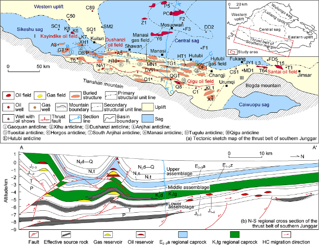
Fig. 1. Sketch map of the structures and oil and gas field distribution in the thrust belt of southern Junggar. P—Permian; T—Triassic; J1-2—Middle-Lower Jurassic; J2-3—Middle-Upper Jurassic; K1tg—Tugulu Group in the Lower Cretacous; K2d—Donggou Formation in the Upper Cretaceous; E1-2z—Ziniquanzi Foramtion in Paleogene; E2-3a—Anjihaihe Formation in Paleogene; N1s—Shawan Formation in Neogene; N1t—Taxihe Formation in Neogene; N2d—Dushanzi Formation in Neogene; Q—Quaternary. |
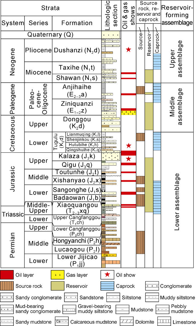
Fig. 2. Stratigraphic column and reservoir-caprock assemblages in the thrust belt of southern Junggar Basin. |
The complexity of tectonic and structural styles, and the development of abnormal high-pressure zones make hydrocarbon accumulation conditions in this area complicated, and the exploration process tortuous. Before 2008, oil and gas exploration activities were mainly concentrated in the middle and upper assemblages. Small and medium-sized oil and gas fields were discovered in a small range in the structural highs in the middle assemblage, and no large oil and gas fields were found yet [15]. After the year of 2008, oil and gas exploration gradually shifted to the lower assemblage. In 2010 to 2012, wells XH1, DF1, and DS1 were drilled in the lower assemblage consecutively, but all failed to discover oil and gas. Until Well GT1 in 2019 and Well HT1 in 2020 tapped high-yield oil and gas flow in the lower assemblage, confirming the broad oil and gas exploration prospect of the lower assemblage and promoting the exploration there [15]. One of the most distinct characteristics of the lower assemblage is the development of strong overpressure. It is of great significance for exploration and evaluation of the lower assemblage to figure out the characteristics, origins and distribution patterns of the overpressure, the controlling effect of overpressure evolution on hydrocarbon accumulation.
2. Overpressure
From the measured formation pressure, drilling fluid density data, it is found abnormal high-pressure is universally developed in the thrust belt of southern Junggar, and overpressure is mainly distributed in Paleogene, Lower Cretaceous, and Middle-Lower Jurassic, but the overpressure in different regions and strata vary greatly in development degree (Fig. 3 ). To describe the overpressure intensity more accurately, the overpressure division scheme of Li et al. [16] is adopted in this paper, that is, the pressure coefficient from 0.9 to 1.2 is defined as normal pressure, and that greater than 1.2 as overpressure. More specifically, the pressure coefficient of 1.2-1.6 is defined as weak overpressure, 1.6-2.0 as strong overpressure, and that greater than 2.0 as extremely strong overpressure.
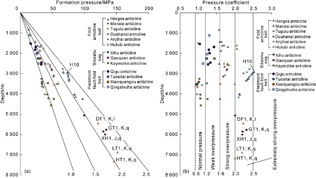
Fig. 3. Relationships between measured formation pressure and depth in the thrust belt of southern Junggar Basin. |
Vertically, the distribution of abnormally high pressure is mainly controlled by the stratigraphic horizons and lithologic combination. Three sets of thick mudstone are mainly developed in the thrust belt of southern Junggar (Figs. 4 and 5 ) from bottom to top, that is, the lower part of Tugulu Group, the middle part of Anjihaihe Formation, and the lower part of Taxihe Formation. Three sets of thick mudstone are the main overpressure developing layers in the region due to tight lithology and poor fluid drainage. Blocked by the two sets of regional overpressured mudstone, E2-3a and the lower part of K1tg, the overpressure compartments are formed vertically, dividing the strata into three sets of reservoir forming assemblages and pressure systems. The upper assemblage above E2-3a is a normal pressure-weak overpressure system, the middle assemblage between E2-3a and the lower mudstone of K1tg is mainly a strong overpressure-locally weak overpressure system, and the lower assemblage below the lower mudstone of K1tg is mainly a strong overpressure-extremely strong overpressure system (Figs. 4 and 5 ). Horizontally, the differences in lithologic combination of different structural belts also have a certain impact on the development of overpressure. In the eastern part of Sikeshu sag, N1t mudstone is more than 1000 m thick, with the rapid deposition since Neogene, overpressure begins to develop in N1t. Well GT1 has the most significant over- pressure in N1t, with pressure coefficients reaching about 1.2-1.6; Well XH1 has lower overpressure intensity due to the smaller thickness of N1t mudstone. Toward the east, due to the thinning of N1t mudstone and the overlying strata, N1t no longer develops overpressure generally. But N1t mudstone in HT1 well area thickens locally to 600 m, so overpressure develops locally to some extent (Fig. 4 ) in N1t. Besides the overpressure zone locally occurring in N1t, a regional stable overpressure top interface appears in the thick E2-3a mudstone.
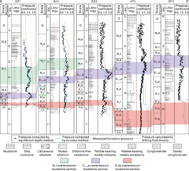
Fig. 4. Formation pressure profiles of five deep wells in the thrust belt of southern Junggar Basin (the profile location is shown in |
The overpressure in Paleogene is mainly distributed in the fold anticline belt and the eastern Sikeshu sag (Fig. 6 a). Previously, it was believed that the overpressure in Neogene and Paleogene was mainly distributed in the Horgos-Manas-Tugulu anticline belt [6⇓-8], but recent exploration revealed that the Neogene and Paleogene of Gaoquan anticline and Xihu anticline in Sikeshu sag also have overpressure zone [16-17]. The Paleogene overpressure in the western segment of the fold anticline belt has the largest intensity, and is strongest in Horgos and Anjihai areas. The Paleogene pressure coefficient of the Horgos reservoir is 2.36-2.46, and that of the Anjihai reservoir is 2.30. From the overpressure center outward, the pressure coefficient decreases gradually. The Paleogene pressure coefficient of Hutubi gas reservoir decreases to 0.93-1.25, and that of Kayindike reservoir is 1.03.
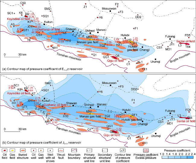
Fig. 6. Planar pressure distribution of the two key formations in the thrust belt of southern Junggar Basin. |
The overpressure system in Jurassic is strong in south and weak in north, strong in west and weak in east (Fig. 6 b). The overpressure center is located in the eastern Sikeshu sag. For example, the reservoir pressure coefficient of Jurassic Toutunhe Formation (J2t) in Well GT1 is 2.20, and that in Well XH1 is 2.18, representing extremely strong overpressure. From the overpressure center outward, the pressure coefficient decreases gradually, and the pressure coefficient of Jurassic reservoir in Well HT1 in the eastern fold anticline belt decreases to 1.82-1.83. The pressure coefficient in the slope area in the west of Sikeshu sag decreases rapidly. For example, the Jurassic pressure coefficient of Kayindike reservoir is only 1.25, and that of Well SS1 is 1.06, which reflects that as the Jurassic strata become shallower in buried depth and connect with the atmospheric fluid at the basin edge, the pressure gradually becomes normal. In the north slope area, the pressure coefficient of Jurassic also gradually decreases, mainly developing weak overpressure. For example, the Triassic-Jurassic in Well PS2 have pressure coefficients of 1.5-1.6 [16]. The Jurassic in the piedmont fault-fold belt exposes to surface directly, where the two sets of regional overpressured mudstone, Anjihaihe Formation and Tugulu Group are missing, and the preservation condition is poor. So the overpressure has released gradually, and forming mainly normal pressure-weak overpressure at present. For example, the pressure coefficient of the Qigu anticline is 1.21-1.40.
In summary, overpressure systems come about in multiple formations in the thrust belt of southern Junggar Basin, and the larger the depth of formation, the larger the overpressure intensity and scale vertically. Laterally, the overpressure system is least developed in the piedmont zone, most developed in the fold anticline belt and the eastern part of Sikeshu sag, and medium developed in the slope area (Figs. 5 and 6 ). Comparing the overpressure distribution in Paleogene and Jurassic shows that these two strata both have strong overpressure areas in the Gaoquan-Dushanzi-Anjihai-Horgos anticline belt. But they have the following differences: (1) The Jurassic has a larger distribution range of overpressure than Paleogene. To the northern slope area, the Jurassic still has weak overpressure, while the Paleogene has a limited distribution of overpressure range. (2) Although similar in maximum pressure coefficient, the Jurassic has much larger excess pressure value than Paleogene (Fig. 5 ), indicating that the lower assemblage has stronger driving force than the middle assemblage. (3) The overpressure zone in the lower assemblage is much thicker than that in the middle assemblage (Fig. 5 ). The lower assemblage has strong overpressure from the bottom of K1q to the thick Jurassic, and even the thick strata of the underlying Triassic and Permian, which is related to the closed fluid environment with large burial depth, tight reservoir and poor fluid drainage in the lower assemblage.
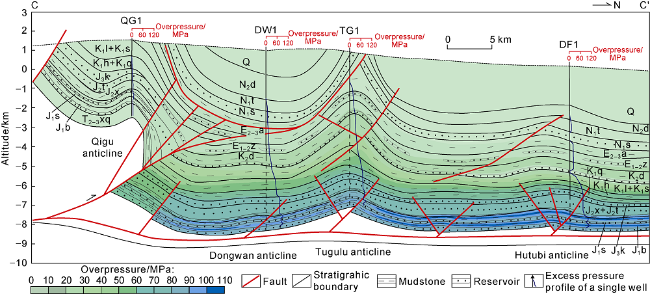
Fig. 5. The N-S excess pressure profile through Well QG1 to Well DF1 (the profile location is shown in |
3. Origins of overpressure and causes of its differential distribution
3.1. Identification of overpressure origins and calculation of their contribution rates
Based on previous studies on the formation mechanisms of overpressure, the causes of overpressure in sedimentary basins can be divided into five types [18⇓⇓-21]: disequilibrium compaction (mainly vertical load), fluid expansion, horizontal tectonic compression, overpressure transmission and diagenesis. Among them, fluid expansion mainly includes hydrocarbon generation, gas generation from oil cracking and hydrothermal process. In the above overpressure mechanisms, fluid expansion, overpressure transmission, horizontal tectonic compression, and diagenesis can cause the unloading of overlying load, which can be referred to as unloading pressurization. In line with the formation and evolution of overpressure in foreland basins, a method for overpressure identification and quantitative evolution simulation suitable for the characteristics of foreland compression has been established, and identification charts of different types of overpressure origins have been made [9-10]. Considering the influence of dual compaction of tectonic stress and vertical load on formation pressure, the PressMod software for numerical simulation of overpressure evolution in foreland basins has been independently developed in this work to fulfill quantitative numerical simulation of the formation and evolution of overpressure of different causes [9].
Taking Well GT1 as an example, the method for identifying different causes of overpressure and calculating the contribution rate of each cause is illustrated. (1) Based on the comprehensive compaction curve of mudstone and the diagram of the relationship between the acoustic velocity of mudstone and the vertical effective stress and mudstone density, the main genetic mechanisms of overpressure were figured out. The mudstone suites less than 2710 m deep in Well GT1 are of normal compaction, while mudstone suites deeper than this depth have the under-compaction feature of abnormally high porosity, and unloading pressurization has an important contribution to the formation of mudstone overpressure in this well [17]. As the mudstone suites of K1q and above in this well have low organic matter contents or no organic matter at all, and the overall thermal evolution degree of the region is low, the mudstone suites haven’t entered main hydrocarbon generation stage, the unloading effect is not caused by hydrocarbon generation pressurization [17]. In addition, previous studies have confirmed that diagenesis such as clay mineral transformation in mudstone is not the main mechanism of overpressure formation in this area[9-10]. Therefore, it is concluded from comprehensive analysis that the unloading effect in the mudstone suites of this area must be caused by tectonic compression. (2) PressMod software was used to quantitatively simulate the influence of deposition and tectonic compression on overpressure formation [9]. The study area has experienced strong tectonic compression from the North Tianshan Mountains since the Himalayan period, especially in the Late Himalayan period. The magnitude of tectonic stress was set according to the previous research results [22]. The magnitude and evolution of under compaction, tectonic compression and overpressure transfer pressurization were obtained from numerical simulation (Fig. 7 ). The generation of overpressure transmission is closely related to the formation of anticlines and the opening of faults. The Xihu and Dushanzi anticlines in Sikeshu sag were formed after 1 Ma [23]. The formation of these structures were associated with the formation and opening of faults, which promoted overpressure transmission along the reservoir sand bodies laterally and along fault vertically. From Fig. 7 , it can be seen that K1q in Well GT1 has formed under compaction during the sedimentary period of N1t, and strong tectonic compression occurred after this period. The good sealing conditions formed have laid the foundation for the formation of tectonic compression pressurization. With the increase of deposition rate and tectonic compression intensity, the degree of overpressure in this area has increased gradually. Since 1 Ma, the formation of faulted anticline has promoted overpressure transmission, making the formation pressure of K1q increase further.
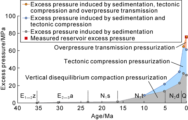
Fig. 7. Evolution of different genetic types of overpressure in the K1q reservoir of Well GT1. |
By using the above method, the overpressure causes of under compaction, tectonic compression and overpressure transmission and their contribution rates to the present overpressure of the key wells, including wells GT1, DS1, XH1, H10, A001, MN001, TG1, DW1 and DF1, were quantitatively analyzed (Figs. 8 and 9 ).
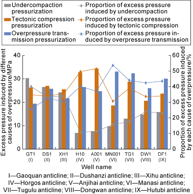
Fig. 8. Histogram of overpressure composition in the top Jurassic reservoir of typical wells in the thrust belt of southern Junggar Basin. |
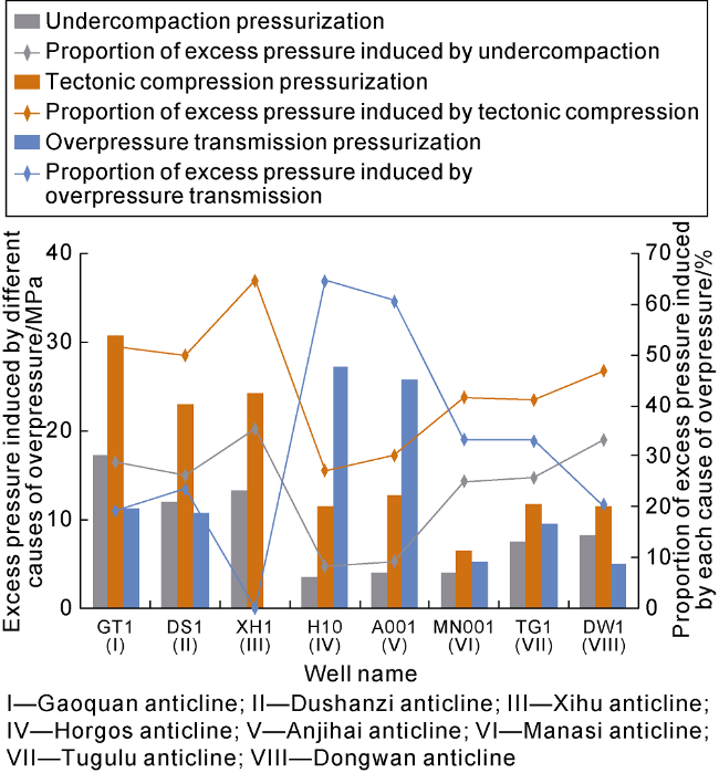
Fig. 9. Histogram of overpressure composition in E1-2z reservoir of typical wells in the thrust belt of southern Junggar Basin. |
3.2. Causes of overpressure differential distribution
Due to the differences in reservoir overpressure origins and their contribution rates in different zones and horizons, the overpressure intensity is distributed differently vertically and horizontally. According to the analysis, the lateral difference of overpressure is mainly controlled by the strength differences of disequilibrium compaction and tectonic compression in different zones. (1) Since Paleogene, the sedimentary-subsidence center has gradually migrated from the middle segment to the western segment. Since Neogene, the stratigraphic thickness center has been located in GT1-XH1-DS1 well area, with the maximum thickness of 4400 m, while the Neogene in Hutubi anticline in the middle segment is only 2600 m thick. Under the influence of this differential subsidence, Jurassic in wells GT1, DS1 and XH1 located in Sikeshu sag have obvious under compaction effect under the early shallow and late rapid deep burial history. Hence, under compaction pressurization has a contribution rate of 33%-40% to the total overpressure of Jurassic, which is greater than its contributation rate in the middle segment (10%-22%) (Fig. 8 ). (2) The study area experienced strong tectonic compression in the Late Himalayan period. According to the simulation results of the tectonic stress field [22], the maximum principal stress of the Jurassic Qigu Formation is located in the Sikeshu sag-Horgos area. From the contribution rate to overpressure, the contribution rate of tectonic compression in Gaoquan, Xihu and Dushanzi anticlines in Sikeshu sag, Huoergusi, and Anjihai anticlines is larger than that of Manas, Hugulu and Hutubi anticlines in the east segment (Figs. 8 and 9 ), which is consistent with the maximum tectonic compression stress in the west segment.
In addition, overpressure transmission also has a significant contribution to the overpressure in the thrust belt of southern Junggar [8⇓-10]. There are multiple faults communicating with deep oil and gas sources in the lower assemblage of the fold anticline belt [24-25]. The pressurization caused by overpressure transmission in these anticlines is generally large (19-33 MPa). The contribution rates of overpressure transmission to total overpressure are 25%-54%. Overpressure transmission has the largest contribution rates in the middle Horgos-Manas-Tugulu anticline belt, as well as Anjihai anticline and Hutubi anticline of 37%-54% (Figs. 8 and 9 ). This may be related to the greater hydrocarbon generation intensity and stronger hydrocarbon charging power of deep Jurassic source rocks in the region. Due to the different fault-caprock combination patterns and degrees of communication between faults and oil source rocks, reservoirs in the middle assemblage of the above anticlines differ widely in communication ability with the deep source rocks [12-13,17]. For example, faults in reservoirs of the middle assemblage in Horgos and Anjihaihe anticlines have good communication with deep oil source rocks. The reservoirs of the middle assemblage in these anticlines have pressure coefficients as high as 2.2-2.4, and overpressure transmission has contribution rate of 60%-65% to overpressure. In contrast, faults in the middle assemblage reservoirs in the Gaoquan, Xihu, and Dushanzi anticlines have poor communication with deep oil source rocks, and thus overpressure transmission has contribution rate of only 0-24% to the total overpressure (Figs. 8 and 9 ).
4. Controlling effect of overpressure on hydrocarbon accumulation
The formation and evolution of overpressure have an important controlling effect on hydrocarbon accumulation and distribution in the thrust belt of southern Junggar, which is mainly manifested in the following three aspects.
4.1. Inhibition of overpressure to degradation of reservoir physical properties
According to the statistics on the physical properties of Cretaceous-Jurassic reservoirs in the thrust belt of southern Junggar, ultra-deep reservoirs more than 6000 m deep have a porosity range from 5% to 10% generally, and primary pores account for 65%-95% of the total pores [26]. Under the same burial depth, the reservoirs have abnormally high porosity, which fully demonstrates that overpressure has a certain protection on reservoir physical properties [17]. Ultra-high pressure is often developed in deep reservoirs in and below the K1q and the formation of the overpressure can inhibit the decrease of reservoir porosity effectively. Therefore, relatively high- quality reservoirs can also be developed in deep reservoirs, which greatly expands the exploration depth of deep reservoirs. Whether overpressure has a strong inhibition effect on degradation of reservoir properties depends on the relationship between overpressure formation and reservoir densification time, which can be divided into the following two cases. (1) If the overpressure was formed before the reservoir densification, it would have a strong inhibition on the degradation of reservoir physical properties. Taking Well XH1 as an example, this area has a burial history of early long-term shallow burial and late rapid deep burial (Fig. 10 a). The numerical simulation shows that the reservoirs would have a porosity of about 2% today if inhibition of porosity reduction by overpressure wasn’t considered. In fact, in the process of rapid burial and strong compression since 18 Ma, strong overpressure began to form in the reservoir. After the overpressure was formed, the effective vertical stress was reduced, and the reduction of reservoir porosity was inhibited. This inhibition can maintain about 6% of the porosity from damage, and finally the reservoir has a porosity of about 8% to now (Fig. 11 a). According to fluid inclusion analysis, it can be determined that the oil charging time in the Upper Jurassic reservoir of Well XH1 is about 13 Ma [27], and the oil charging time is consistent with the overpressure formation time. Moreover, the reservoir has not entered the densification stage when oil charged, so the oil charging and overpressure work jointly to maintain the reservoir physical properties. (2) If strong overpressure is formed after reservoir densification, the overpressure has a weaker inhibition on degradation of reservoir physical properties. Taking Well DF1 as an example, this well has the characteristic of continuous and stable burial (Fig. 10 b), reservoirs in this well had entered densification stage before the formation of strong overpressure, and the later overpressure also has inhibited reduction of reservoir porosity, but only about 2% of porosity is preserved from destruction (Fig. 11 b). Although reservoirs in the lower assemblage of this area have poorer physical properties, the oil and gas charging power in this area is strong, and the oil and gas generated by the deep Jurassic and Permian source rocks can also effectively charge into reservoirs in the lower assemblage. The overpressure composition evaluation of the Jurassic reservoirs in Well DF1 shows that the overpressure transmission accounts for about 43% of the total excess pressure (Fig. 8 ), which confirms that the reservoirs have experienced strong oil and gas charging. The high production of Well HT1 also confirms this conclusion.
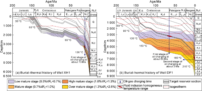
Fig. 10. Burial and thermal history of wells XH1 and DF1 in the thrust belt of southern Junggar Basin. |
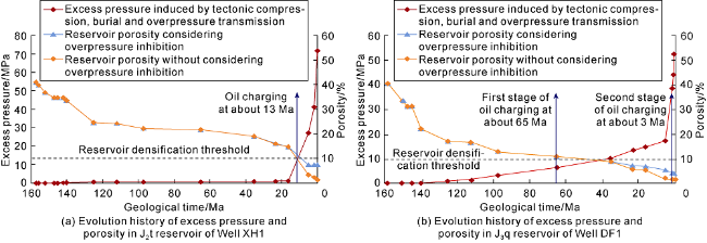
Fig. 11. Evolution of excess pressure and porosity in wells XH1 and DF1 in the thrust belt of southern Junggar. |
4.2. Sealing effect of overpressured mudstone caprock on hydrocarbon
The overpressured mudstone caprock has a good sealing effect on the underlying oil and gas by capillary pressure sealing and overpressure sealing, which is the key to the formation and maintenance of the two sets of overpressure systems in the middle and lower assemblages. On one hand, the pressure in the overpressured mudstone caprock is often greater than that in the underlying reservoirs. This pressure difference would increase the capillary sealing ability of the caprock and the height of hydrocarbon column the caprock can seal[28]. On the other hand, the overpressured mudstone suites of E2-3a and K1tg, with lower elastic modulus and shear strength, are mechanical weak layers in the region. Acting as detachment layers, they control the vertical stratified structural deformations (Fig. 1 b) [29]. Faults in the plastic overpressure mudstone sections turn gentler in dip angle or heal, and thus enhancing in sealing capacity. Therefore, with the connectivity of faults and the sealing of overpressured mudstone sections, strata under the overpressured mudstone caprocks of E2-3a and K1tg are the main sites for oil and gas enrichment.
In the middle assemblage, the overpressured mudstone caprock of E2-3a controls the vertical distribution of oil and gas reservoirs strictly. Oil and gas reservoirs discovered so far are mostly located under the overpressured mudstone of E2-3a. Only Dushanzi, Anjihai, and Horgos anticlines are destroyed by the cross-layer faults, and a small amount of oil and gas is migrated to the upper assemblage (Fig. 12 ). In the lower assemblage, the thick overpressured mudstone in the lower part of K1tg provides favorable conditions for the accumulation and preservation of oil and gas. Under the control of the thick overpressured mudstone detachment layer of K1tg, the faults in the middle assemblage slip along the mudstone section of K1tg, and the faults in the lower assemblage haven’t cut through the thick mudstone of K1tg, providing an important guarantee for the integrity of the structural traps in the lower assemblage (Fig. 5 ). In recent years, wells such as GT1 and HT1, marking major breakthroughs have revealed the oil and gas exploration potential of the overpressure system in the lower assemblage. In the piedmont fault-fold zone where the two sets of overpressured mudstone caprocks are absent, most of the Jurassic formations directly expose to the surface, with the overpressure gradually released. At present, they have largely normal pressure to weak overpressure zones. A small amount of oil and gas can accumulate under the cover of local mudstone caprocks in the Jurassic-Triassic, but are limited in scale and productivity (Fig. 12 ).
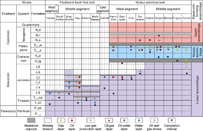
Fig. 12. Relationships between regional caprocks, reservoir-forming assemblages and hydrocarbon-bearing formations in the thrust belt of southern Junggar Basin. |
4.3. Moderate overpressure intensity is favorable for oil and gas enrichment and preservation conditions
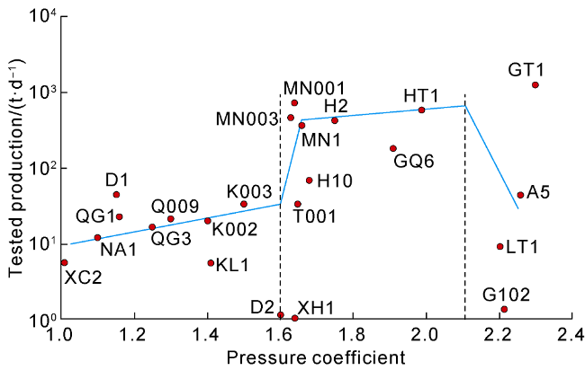
It can be seen from the statistical relationship between the oil and gas productivity and formation pressure coefficient of individual wells in the thrust belt of southern Junggar that, in general, with the increase of the pressure coefficient, the oil and gas productivity of individual well gradually increases (Fig. 13 ). For oil and gas reservoirs with a pressure coefficient greater than 1.6, the daily production of individual well went up in leaps and bounds, but when the reservoir pressure coefficient is greater than 2.1, the daily production of individual well dropped on the whole over time. The Cretaceous reservoir in Well GT1 has a pressure coefficient of 2.32, although the well tested a daily production up to 1259.7 t/d, it dropped rapidly in production and produced water soon in production test, so its high production tested cannot represent the real oil and gas productivity. Therefore, under the background of overall strong overpressure, overpressure intensity too high or too low are both not conducive to the enrichment and preservation of oil and gas. Generally, reservoirs with pressure coefficients between 1.6 and 2.1 are more favorable, which is consistent with the previous study results that overpressure transition zones with medium pressure coefficients are favorable parts for oil and gas exploration [30]. This is mainly due to the following three reasons.
Fig. 13. Relationship between daily oil production and pressure coefficient of individual wells in the thrust belt of southern Junggar. |
(1) Overpressure charging is a prerequisite for the tight sandstone to get high gas saturation and high gas production [31]. As the reservoirs in the lower assemblage in the southern Junggar have poor physical properties in general, the greater overpressure intensity of the reservoir indicates the stronger the hydrocarbon charging power, which is more conducive to the charging of oil and gas.
(2) When the overpressure intensity currently is too high (pressure coefficient is greater than 2.1), on one hand, hydraulic fracturing is likely to happen, which is not conducive to the preservation of oil and gas; on the other hand, the excess pressure difference between the source rock and reservoir would be lower, which is not conducive to the charging of oil and gas either. When the overpressure intensity is too high (with pressure coefficient exceeding 2.2), and the pressure is close to the rock fracture pressure, hydraulic fracturing is likely to take place, resulting in oil and gas leakage. Under the control of hydraulic fracturing, the dynamic hydrocarbon column height that can be sealed by an extremely strong overpressure trap is very limited, so the large-scale reservoir cannot be formed [17,32 -33]. A typical example is the Cretaceous reservoir in Well GT1. The measured formation pressure coefficient at 5771.5 m in K1q is 2.32, which is very close to the maximum critical pressure coefficient of 2.35 for the preexisting faults in the cap rock to slide, indicating that the reservoir pressure of K1q is close to the critical state. It was predicted that the maximum oil column height of the K1q reservoir in Well GT1 is about 200 m [17], which is much lower than the closure height of 500 m of the Gaoquan anticline trap. After the oil discovery of Well GT1, wells G101 and G102, two evaluation wells for Gaoquan anticline, tested poor oil and gas shows. Well GT1 had production plummeting rapidly and water coming out during production test, suggesting that the Cretaceous reservoir in Well GT1 is small in scale, and the hydraulic fracturing of caprock caused by extremely strong overpressure limits the height of hydrocarbon column in the reservoir [17]. There are many mud volcanoes and oil and gas seeps exposed in the western segment of the thrust belt of the southern Junggar, such as the Dushanzi, Tostai, and Sikeshu mud volcanos [34]. The formation and development of these mud volcanoes is related to the strong overpressured oil and gas reservoirs in the middle and lower assemblages of the western segment, reflecting the dynamic pressure and fluid release of the extremely overpressured traps.
(3) In the context of overall overpressure in the thrust belt of southern Junggar, overpressure intensity too low (pressure coefficient of less than 1.4) indicates that the preservation conditions are poor, resulting in pressure and hydrocarbon leakage. For example, after strong uplift and denudation, the Jurassic reservoirs in the piedmont fault-fold belt turned poor in preservation condition with released overpressure, so the reservoirs have low pressure coefficients of less than 1.4 generally. In the process of strong uplift, the mudstone caprocks were prone to rupture and failure, leading to oil and gas leakage, and damage of most of the oil and gas reservoirs [35-36]. Therefore, except a small amount of residual oil and gas found in the Qigu anticline, only a small amount of oil and gas shows were detected in other structures in the piedmont belt.
5. Conclusions
In the thrust belt of southern Junggar, overpressure is universal, overpressure systems come about in multiple formations, and the larger the depth, the larger the overpressure intensity is. The overpressure is mainly distributed in Paleogene, Lower Cretaceous, and Middle-Lower Jurassic, but overpressure intensity varies greatly in different regions and strata. Vertically, the distribution of overpressure is mainly controlled by the stratigraphic horizons and lithologic combinations. Laterally, the overpressure intensity is the highest in the fold anticline belt and decreases gradually from there to the surrounding.
Tectonic compression is the main cause of overpressure, followed by under compaction and overpressure transmission. The difference in planar overpressure distribution in the thrust belt of southern Junggar is controlled by the difference in strength of under compaction and tectonic compression in different regions. The vertical overpressure transmission caused by faults connecting deep overpressured strata has an important contribution to the further increase of overpressure intensity in this area.
The formation and evolution of overpressure in the thrust belt of southern Junggar play an important role in controlling oil and gas accumulation and distribution. Specifically, when the strong overpressure is formed before the reservoir densification, overpressure plays an important role in maintaining the physical properties of deep reservoirs, making the exploration depth expand. Strata under overpressured mudstone caprocks of E2-3a and K1tg are the main sites for oil and gas enrichment. In the context of overall strong overpressure, overpressure intensity too high or too low are both not conducive to oil and gas enrichment and preservation, and the pressure coefficient between 1.6 and 2.1 is the best.