

Introduction
Epicontinental sea is a shallow-water inland sea or within a continental shelf. It is usually gentle (bottom slope less than 0.1°), extensive (hundreds to thousands of kilometers) and shallow (only dozens of meters) [1]. Two sedimentary models, namely clear-water sedimentation model dominated by carbonate deposits and muddy-water sedimentation model dominated by fine clastic deposits, have been identified in epicontinental seas [2]. Epicontinental deposits were developed extensively in the Upper Yangtze region throughout the Ordovician-Silurian period. The Upper Yangtze region mainly developed sediments of clear-water carbonate platform before the Late Ordovician [3], and was dominated by muddy-water fine clastic sediments later due to an increased supply of terrigenous clasts as the result of active tectonic activities and volcanic eruption from the Late Ordovician to the Early Silurian [4⇓-6]. Consequently, the Upper Ordovician Wufeng Formation- Lower Silurian Longmaxi Formation (Wufeng-Longmaxi) shale as thick as 500 m was formed. With high contents of TOC, gas and biogenic silica, and the presence of organic pores, beddings [7] and microfractures [8], the Wufeng-Longmaxi shale has been the key target for gas exploration and development. Early research has confirmed the controlling role of sedimentary facies on the mineral compositions, beddings and TOC [9]. Many researches have been conducted on the sedimentary facies. It is generally believed that the sedimentary facies in the Wufeng-Longmaxi shale include shelf and tidal flat [10⇓-12], of which shelf is subdivided into shallow shelf and deep shelf [10,13⇓⇓⇓ -17]. When the Wufeng-Longmaxi shale deposited, the paleoclimate was warm and humid [18-19], the sea level rose rapidly [20-21], the water in the basin was mainly laminar flow [22-23], the environment was anoxic and sulfidic [24-25] and the supply rate of sediments was low [6-7]. Compared with coarse clastic rocks and carbonate, shale demonstrates finer grain size, hardly identifiable laminae and bedding, and absence of trace fossils [26], which hinder the subdivision and mapping of sedimentary microfacies of the Wufeng-Longmaxi shale and greatly restrict the evaluation of shale gas resource and prediction of favorable zones. In this study, laminae and bedding were identified by full-scale observation of large thin sections, grain sizes were measured by argon-ion polishing field emission-scanning electron microscopy (FE-SEM), organic matter types were detected by kerogen microscopy, and whole-rock mineral compositions were analyzed by X-ray diffraction (XRD). Then, the sedimentary microfacies were classified. Finally, an innovative single-factor analysis and multifactor mapping method [27] was proposed to describe the distribution of the microfacies.
1. Geological setting
The interval from the Upper Ordovician Wufeng Formation to the Lower Silurian Longmaxi Formation deposited when the South China Basin disappeared and the South China orogenic belt appeared [28⇓-30]. The Guangxian Orogeny led to the convergence of the Yangtze plate with the Cathaysia landmass [31] and successive uplifting of the Southeast Basin and the Jiangnan Basin in the Yangtze region during the Late Cambrian, when the Yangtze region was converted from a passive continental margin basin to a foreland basin [19,28]. The Yangtze region experienced changes in dominant sediments from Early- Middle Ordovician carbonate platform sediments [19,32] to Late Ordovician clastic-carbonate mixed platform sediments and carbonate ramp sediments [10]. During the Ordovician-Silurian, the global sea level rose quickly and the ancient land uplifted extensively [4]. From south to north, the Central Guizhou uplift, the Wuyi-Yunkai uplift, the Xuefeng uplift, the Leshan-Longnüsi uplift and the Hannan old land were formed successively within the Yangtze region. The Middle-Upper Yangtze post-uplift basin was located between foreland uplifts (Fig. 1 a), and the paleo-environment was mainly a shallow-sea and deep-water basin [33]. During the Early Silurian, with the enhanced N-E compression, the Upper-Middle Yangtze region was uplifted continuously and the Leshan- Longnüsi Uplift was expanded gradually, making the sea scope diminishing and water become shallow, consequently intensified sedimentary differentiation. The Middle-Upper Yangtze region was sandwiched between the Leshan-Longnüsi uplift and the Central Guizhou- Xuefeng uplift, where semi-closed stagnant basin sediments were dominant [4,34].
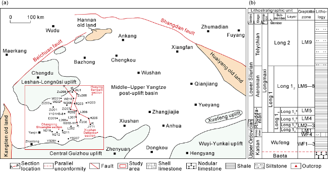
The southern Sichuan Basin is located at the southwest margin of the Upper Yangtze platform, South China. It is the area surrounded by the Daliang Mountain to the east, the erosion line of the Longmaxi Formation in the Leshan-Longnüsi uplift to the south, the Huaying Mountain to the west and the Northern Guizhou sag to the north [35], covering about 4×10⁴ km2 (Fig. 1 a). The Wufeng-Longmaxi shale, which was developed during the Late Ordovician-Early Silurian, is extensive, with the thickness of 0-500 m, in the study area. The Wufeng Formation is in parallel unconformity contact with the underlying Upper Ordovician Baota Formation nodular limestone (Fig. 1 b), and is divided into two lithologic members according to the lithological features, electrical properties and graptolite fossils. The lower one, corresponding to the WF1-WF3 graptolite zones, is mainly composed of thick black shale with multiple thin layers of volcanic ash; the upper one, corresponding to the WF4 graptolite zone, mainly consists of shell limestone with abundant Hirnantia Fauna fossils [37]. The Longmaxi Formation is in conformable contact with the underlying Wufeng Formation, and includes the Long 1 and Long 2 members, corresponding to LM1-LM8 and LM9 graptolite zones, respectively [36,38]. The Long 1 Member is subdivided into the Long 11 and Long 12 submembers, corresponding LM1-LM5 and LM6-LM8 graptolite zones, respectively. Long 11 is further subdivided into four layers, Long 111 to Long 114, corresponding to LM1, LM2-LM3, LM4 and LM5 graptolite zones, respectively. The Long 1 Member is mainly composed of black and dark gray laminated shale or massive shale. As characterized by high TOC, favorable oil-bearing properties and developed laminae and microfractures [8-9], Long 11 is a high-quality interval for shale gas exploration and development at present. The Long 2 Member consists of greyish green and yellow-green shale, with siltstone or argillaceous limestone locally, and has the upward-increasing sand content, forming an upward-coarsening sedimentary sequence.
When the Wufeng-Longmaxi formations deposited, the Leshan-Longnüsi uplift and the Central Guizhou-Xuefeng uplift were located respectively in the north and south of the southern Sichuan Basin, and the shale between them thinned out from the depocenter to the north and south sides. The Leshan-Longnüsi uplift developed three large topographic breaks southward. Above topographic break 1, the terrain was relatively flat. Between topographic break 1 and topographic break 2, the steep terrain resulted in rapid thinning out of the formations. Between topographic break 2 and topographic break 3, the terrain was relatively flat. Below topographic break 3 was a low-lying landform [39].
2. Samples and methods
2.1. Samples and procedures
The target interval is the Wufeng Formation-Long 11. The research data include geochemical logging data, conventional logging data and stratigraphic data from 215 wells and 3 outcrop sections. Systematic analyses and tests were carried out on samples from 19 wells (Zi201, Zi203, Zu206, Zu208, W201, W202, W206, W210, N211, N212, N218, H206, Y101H3-8, YS201, YS207, D201, L208, L202 and H203) and 3 outcrop sections (Xiushan Datianba, Huaying Sanbaiti, and Changning Shuanghe), including conventional thin section observation (125 samples), full-scale observation of large thin section (60 samples), FE-SEM analysis (60 samples), XRD whole-rock analysis (200 samples) and kerogen microscopy (60 samples), in the Experimental Center of RIPED (PetroChina Research Institute of Petroleum Exploration & Development).
The process includes four steps:
(1) Systematic core characterization and outcrop observation were carried out to clarify the lithology, interlayer features and colors, laminae/bedding, and microfractures of the black shale, and to identify the sedimentary microfacies preliminarily.
(2) Standard characteristic plates of microfacies were mapped through observations of conventional and large thin sections, FE-SEM analysis, XRD whole-rock analysis and kerogen microscopy, to further confirm the types and characteristics of the sedimentary microfacies.
(3) Contours of shale thickness, silica content, calcium content, clay minerals content and U/Th were mapped by using the single-factor analysis and multifactor mapping method [24], to determine the plane distribution of the sedimentary microfacies.
(4) A sedimentary microfacies model of the black shale was established based on the research results of structural setting, paleo-source and paleo-climate.
2.2. Identification of laminae and bedding
Laminae and bedding were identified by full-scale observation of large thin sections (5 cm × 7 cm × 30 μm). A Leica 4500P high-precision digital platform was used to take photos of whole-thin sections, and 3200 images were acquired from a large thin section. Adobe Photoshop CS5 or above was used to seamlessly splice the 3200 images on a high-end workstation to make a full-size thin section image. Then the types and characteristics of bedding were identified based on the relationship between laminae, laminaset and beds.
2.3. Grain-size analysis
Using an FE-SEM, the grain size was analyzed through the following steps: preparation of argon-ion polished section, image acquisition and statistical calculation of grain size. A Hitachi FE-SEM fitted with cold discharge and equipped with a secondary electronic probe and an X-ray energy dispersive spectroscopy (EDS) was used for photo acquisition. The magnification of SEM was about 2500 times (50 μm a single photo). Nano Measurer 1.2 developed by Peking University was used to measure the sizes of 50-100 mineral grains on 2-3 typical SEM images. The size distribution and average sizes were obtained.
3. Types and characteristics of sedimentary facies
Delta, tidal flat and shelf facies have been identified in the shale according to the mineral composition, grain size, laminae/bedding, and types of organic matter (Table 1 ).
Table 1. Sedimentary facies of the Wufeng Formation-Long 11 shale in southern Sichuan Basin |
| Type | Facies | Subfacies | Microfacies | Location | Typical well/section |
|---|---|---|---|---|---|
| Transitional | Delta | Delta front | Underwater distributary channel, interdistributary bay | Above topographic break 1 | Wells B1, YS201 and YS207 |
| Tidal flat | Intertidal flat | Calcareous flat and clayey flat | Between average high-water line and normal wave base | Xiushan Datianba section, Well B1 | |
| Marine | Shelf | Shallow shelf | Calcareous and clayey shelf | Between normal wave base and topographic break 1 | Wells W231, YQ1, YQ3 and YS128 |
| Deep shelf | Deep slope | Between topographic break 1 and topographic break 2 | Wells W232, Zi207, Zu201 and DS1 | ||
| Deep plain | Between topographic break 2 and topographic break 3 | Wells R202, L211, N210 and H202 | |||
| Deep depression | Below topographic break 3 | Wells L208, N211 and TH1, and Changning Shuanghe section | |||
| Gravity flow | Overflow | Below topographic break 1 | Wells N219, N240, W205 and H205 |
3.1. Delta facies
Delta facies was developed above topographic break 1 (Fig. 2 ). The delta front subfacies including underwater distributary channel and interdistributary bay microfacies has been drilled by wells B1, YS201 and YS207 in the study area. It was developed in an oxygen-rich environment (U/Th=0.66). And greatly controlled by the supply of continental sediments, the delta front shale is characterized by coarse grain size, high terrigenous clastic content and low TOC (Table 2 ).
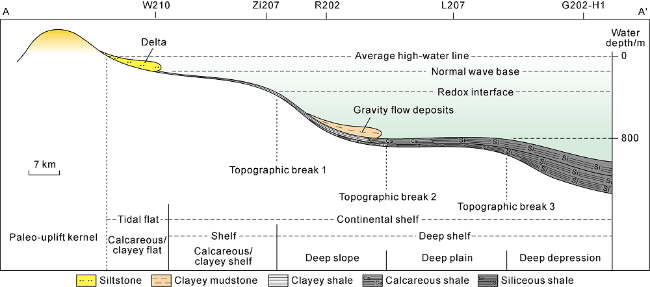
Fig. 2. Paleotopography and microfacies of the Wufeng Formation-Long 11 shale in the south of the Leshan-Longnüsi uplift, southern Sichuan Basin (modified from Reference [39]). |
Table 2. Microfacies of the Wufeng Formation-Long 11 shale in southern Sichuan Basin |
| Item | Composition | Mineral content/% | Sedimentary structure | Kerogen type | U/Th | Topographic slope/ (m·km-1) | ||
|---|---|---|---|---|---|---|---|---|
| Facies | Subfacies | Microfacies | ||||||
| Delta | Delta front | Underwater distributary channel | Coarse silt (>30%) | Calcite and dolomite greater than 40% | Lenticular bedding and graded bedding | Types II1 and II2 | 0.66 | 0.25 |
| Interdistributary bay | Coarse silt (<30%) Fine silt (>50%) | Clay minerals greater than 40% | Massive bedding | |||||
| Tidal flat | Intertidal flat | Calcareous flat | Fine silt (>95%) | Calcite and dolomite greater than 40% | Wavy bedding, small cross bedding and graded bedding | Type II 1 | 0.35 | 0.25 |
| Clayey flat | Clay minerals greater than 50% | |||||||
| Shelf | Shallow shelf | Calcareous shelf | Fine silt (90%-95%) | Calcite and dolomite 30%-40% | Silt-mud alternated horizontal bedding | Type I | 0.44 | 0.25 |
| Clayey shelf | Clay minerals greater than 50% | |||||||
| Deep shelf | Deep slope | Fine silt (70%-90%) | Calcite and dolomite 20%-30% | Silt-mud alternated horizontal bedding, Silt-mud graded horizontal bedding | Type I | 0.77 | 0.5-1 | |
| Deep plain | Fine silt (50%-70%) | Calcite and dolomite 10%-20% | Shaly horizontal bedding, Silt- mud graded horizontal bedding | Type I | 1.32 | <0.1 | ||
| Deep depression | Fine mud (>50%) | Silica greater than 55% | Shaly horizontal bedding | Type I | 1.44 | 0.3-0.7 | ||
| Gravity flow | Overflow | Fine mud (>50%) | Clay minerals greater than 35% | Normal graded structure, deformed structure, scoured and filled structure, graded bedding, wavy bedding and horizontal bedding | Type I | 1.32 | ||
(1) The underwater distributary channel microfacies is dominated by calcite and dolomite (greater than 40%), quartz (greater than 30%) and clay minerals (greater than 20%), and contains a small amount of plagioclase and K-feldspar. The core samples are gray and black gray, with lenticular bedding and graded bedding. The analysis results show that the core samples are mainly composed of coarse silt (greater than 30%) and fine siltstone, and the coarse siltstone is higher than 30%. The siltstone occurs as mixed deposits in fine mudstone in a state of suspension (Fig. 3 a). The coarse and fine silts are mainly calcite, dolomite, detrital quartz, plagioclase and clay minerals. Observed under SEM, the shale of underwater distributary channel microfacies is grain-supported (Fig. 4 a). The grayish white calcite and light gray dolomite are angular-subangular, with grain sizes of 21-93 μm (avg. 57 μm), and scattered or locally layered distribution. The detrital quartz is gray, and angular-subangular, with grain sizes of 24-78 μm (avg. 59 μm) and scattered distribution. The clay minerals mainly appear as flakes and bands, with grain sizes of 35-95 μm (avg. 55 μm).
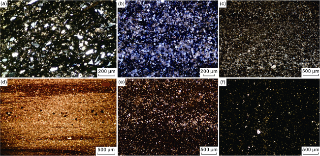
Fig. 3. Microscopic characteristics of conventional thin sections of the Wufeng Formation-Long 11 shale, southern Sichuan Basin. (a) Underwater distributary channel, hybrid accumulation, Well YS201, 2764.02 m, under cross-polarized light; (b) Tidal flat, grain-supported structure, Xiushan Datianba section, under cross-polarized light; (c) Shallow shelf, grain-supported structure, normal graded bedding, Well Zi203, 3006.76 m, under cross-polarized light; (d) Deep slope, grain-supported structure, Well 206, 4275.10 m, under cross-polarized light; (e) Deep plain, matrix-supported structure, Well L208, 3840.77 m, under cross-polarized light; (f) Deep depression, fine mud in dominance, Huaying Sanbaiti section, under cross-polarized light. |
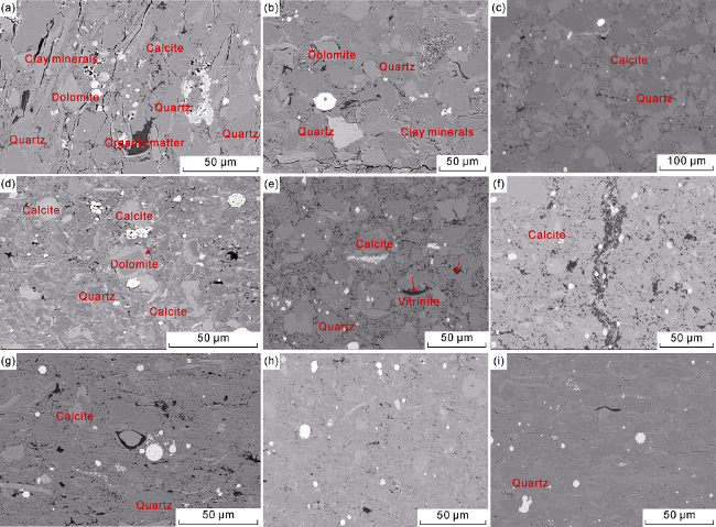
Fig. 4. SEM characteristics of the Wufeng Formation-Long 11 shale in southern Sichuan Basin. (a) Delta front, scattered sapropelinite, Xiushan Datianba section; (b) Tidal flat, layer #8, Xiushan Datianba section; (c) Shallow shelf, grain-supported structure, Well W210, 3228.70 m; (d) Deep slope, Well W206, 3753.86 m; (e) Deep plain, dispersed sapropelinite, vitrinite as small flakes, Well N211, 2350.25 m; (f) Deep depression, Well H206, 4355.50 m; (g) Gravity flow, organic matter in scattered distribution, Well W210, 3248.91 m; (h) Gravity flow, organic matter in scattered distribution, Well Y101H3-8, 3747.18 m; (i) Gravity flow, organic matter in scattered distribution, Well N211, 2321.05 m. |
(2) The interdistributary bay microfacies has rich clay minerals (greater than 40%), quartz (greater than 30%), calcite and dolomite (greater than 20%). The core samples are black gray, have laminated and massive beddings, and mainly consist of fine silt (greater than 50%). Observed under SEM, the shale of interdistributary bay microfaxies is a mixture of clay minerals, calcite, dolomite, and detrital quartz. The clay minerals appear as flakes and bands, with an average grain size of 43 μm. The calcite and dolomite are angular-angular, with an average grain size of 29 μm. The detrital quartz is also angular-subangular, with an average grain size of 27 μm.
The kerogens in the shales of underwater distributary channel and interdistributary bay are dominantly Type II1 and Type II2, with a relatively low content of sapropelinite. Extending seaward, sapropelinite increases.
3.2. Tidal flat facies
The tidal flat facies is located between the average high water line and the normal wave base (Fig. 2 ). Intertidal flat subfacies have been identified in the study area, including calcareous flat and clayey flat microfacies, and drilled on the Xiushan Datianba section and in Well B1. As deposited in the area with a small topographic slope (less than 0.25 m/km) and oxygen-rich water (U/Th=0.35) and little influenced by the supply of terrigenous sediments, the tidal flat facies has low TOC content, high content of carbonate or clay minerals, and coarse grains (Table 2 ).
(1) The calcareous flat microfacies is dominated by calcite and dolomite (greater than 40%), quartz (20%-30%) and clay minerals (less than 20%), and its core samples generally present black gray color and have massive texture. The shale of calcareous flat microfacies is mainly composed of fine silt (greater than 95%), and grain-supported (Fig. 3 b), and locally has basal cements of penecontemporaneous calcite (Fig. 4 b). Observed under SEM, the quartz is angular-subangular, with the grain size of 10.90-38.79 μm (avg. 23.9 μm); the calcite is angular-subangular, with the average grain size of 26.2 μm; the dolomite is angular-subangular, with the average grain size of 22.7 μm; and the clay minerals appear as strips, with grain sizes of 11.6-58.1 μm (avg. 27.2 μm).
(2) The clayey flat microfacies is mainly composed of clay minerals (greater than 50%), quartz (20%-30%), and calcite and dolomite (less than 20%), and has similar characteristics to the calcareous flat in other aspects.
Small cross-bedding (Fig. 5 a), wavy bedding (Fig. 5 b) and graded bedding are observed in both the calcareous and clayey flats. The organic matter is type II1 kerogen, dominated by exinite (up to 95%), but no sapropelinite. In the Wufeng-Longmaxi shale, the calcareous flat is distributed in the Wufeng Formation-lower Long 11, while the clayey flat is in the upper Long 11.
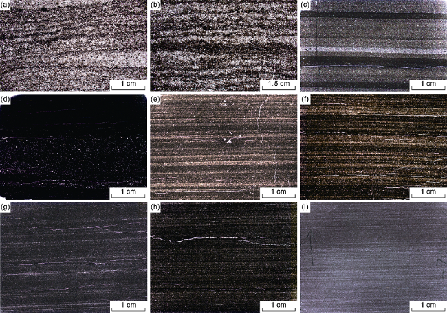
Fig. 5. Bedding characteristics of the Wufeng Formation-Long 11 shale in southern Sichuan Basin. (a) Tidal flat, small cross bedding, Xiushan Datianba section; (b) Tidal flat, small wavy bedding, Xiushan Datianba section; (c) Shallow shelf, silt-mud alternated horizontal bedding, 2570.09 m, Well W202; (d) Shallow shelf, small normal graded bedding, 2573.80 m, Well W202; (e) Deep slope, silt-mud alternated horizontal bedding, Longmaxi Formation, Changning Shuanghe section; (f) Deep slope, silt-mud graded horizontal bedding, Longmaxi Formation, Changning Shuanghe section; (g) Deep plain, shaly horizontal bedding, 3668.80 m, Well Zi201; (h) Deep depression, shaly horizontal bedding, 2342.05 m, Well N211; (i) Deep depression, shaly horizontal bedding, 3783.40 m, Well Y101H3-8. |
3.3. Shelf facies
The shelf facies was developed below the normal wave base (Fig. 2 ). It is subdivided into shallow shelf and deep shelf subfacies by three topographic breaks.
3.3.1. Shallow shelf subfacies
The shallow shelf subfacies is located between the normal wave base and the topographic break 1 (Fig. 2 ). It has been drilled by Wells W231, YQ1, YQ3 and YS128. As deposited in the environment with a small topographic slope (less than 0.25 m/km), shallow water, and rich oxygen (U/Th=0.44), and little influenced by the supply of terrigenous sediments, the shallow shelf shale has abundant calcium and coarse grains (Table 2 ). According to the mineral composition, calcareous shelf and clayey shelf microfacies were identified. The calcareous shelf shale has a higher content of calcite and dolomite, while the clayey shelf shale has a higher content of clay minerals.
(1) The calcareous shelf shale is composed of calcite and dolomite (30%-40%), clay minerals (20%-30%), quartz (20%-30%), and a small amount of plagioclase. It is dominated by fine silt (greater than 90%), and generally grain-supported (Fig. 3 c). Observed under SEM, the calcite is irregular (Fig. 4 c), and has dissolved edges, with the grain size of 6.7-24.6 μm (avg. 17.5 μm); the dolomite is generally light gray, diamond-shaped, and calcilized at edges, with dissolved pores and the grain size of 5.5-26.7 μm (avg. 16.4 μm); the quartz is granular, with the grain size of 12.6-34.4 μm (avg. 12.6 μm) and even up to 42 μm locally; the clay minerals consist of illite (avg. 68%) and a small amount of kaolinite (19%), chlorite (9%) and illite/smectite (4%). Silt-mud alternated horizontal bedding (Fig. 5 c) and local small normal graded bedding (Fig. 5 d) are observed.
(2) The clayey shelf shale is composed of clay minerals (greater than 50%) and a small amount of calcite and dolomite. Observed under SEM, the clay minerals are dominated by illite, with an average grain size of 25.6 μm. Silt-mud alternated horizontal bedding and local small-sacale normally grading bedding are observed.
Organic matter in the shallow shelf shale is type I kerogen, with sapropelinite up to 95%.
3.3.2. Deep shelf subfacies
The deep shelf subfacies is located below topographic break 1 (Fig. 2 ), including deep slope, deep plain and deep depression microfacies.
(1) The deep slope microfacies is located between topographic break 1 and topographic break 2 (Table 1 and Fig. 2 ), and has been drilled by wells W232, Zi207, Zu201 and DS1. In the deep slope, the water is strongly reducing (U/Th=0.77), the topographic slope is 0.5-1.0 m/km, and sediments may easily slump to form gravity flow deposits (Table 2 ).
The deep slope shale is composed of quartz (30%-40%), calcite and dolomite (20%-30%), clay minerals (20%-30%), and a small amount of plagioclase. It is dominated by fine silt and fine mud, and generally grain-supported (Fig. 3 d). The fine silt accounts for more than 70%, including quartz, dolomite, calcite, clay minerals, and a small amount of plagioclase and pyrite. Observed under SEM (Fig. 4 d), the quartz has the grain size ranging from 3.89 to 11.04 μm (avg. 6.75 μm); the dolomite is generally diamond-shaped, and replaced by calcite at edges, with the grain size of 4.43-32.37 μm (avg. 8.92 μm); the calcite is irregular, with the grain size of 5.35-16.49 μm (avg. 9.25 μm); and the clay minerals are generally fragmented, with an average grain size of 14 μm. The fine mud is mainly authigenic microcrystalline quartz, with the grain size smaller than 4 μm. Silt-mud alternated horizontal bedding (Fig. 5 e) and silt-mud graded horizontal bedding are observed (Fig. 5 f). Compared with the shallow slope shale, the deep slope shale contains less silty lamina and more muddy lamina. The organic matter is dominated by type I kerogen, with sapropelinite up to 95%.
(2) The deep plain microfacies is located between topographic break 2 and topographic break 3 (Fig. 2 ), where the water is anaerobic (U/Th=1.32), the topographic slope is smaller than 0.1 m/km and the hydrodynamic condition is stable (Table 2 ). The deep plain shale has been drilled by Wells R202, L211, N210 and H202.
The deep plain shale is mainly composed of quartz (40%-55%), clay minerals (20%-30%), and calcite and dolomite (10%-20%), and a small amount of plagioclase and K-feldspar. Its grains are dominated by fine silt (greater than 50%) and fine mud, and generally matrix-supported (Fig. 3 e). The fine silt includes quartz, dolomite, calcite, clay minerals, and a small amount of plagioclase. Observed under SEM, the quartz is gray and granular with an average grain size of 7.6 μm; the calcite generally appears as grayish white and irregular grains (Fig. 4 e) with an average grain size of 5.17-20.62 μm (avg. 10.23 μm); and the dolomite is generally diamond-shaped and replaced by calcite at edges, with the grain size of 5.39-22.23 μm (avg. 13.83 μm). The fine mud, with the grain size smaller than 4 μm, is mainly microcrystalline quartz. Shaly horizontal bedding (Fig. 5 g) and local silt-mud graded horizontal bedding are observed. The proportion of silty lamina decreases with water depth. The organic matter is type I kerogen, with sapropelinite accounting for 94%-98% (Table 2 ).
(3) The deep depression microfacies is located below topographic break 3 (Fig. 2 ), where the water is anaerobic (U/Th=1.44) and deep, the topographic slope is 0.3-0.7 m/km, and the influence of terrigenous clastic source is little. It has been found in wells L208, N211 and TH1 and on the Changning Shuanghe section.
The deep depression shale is composed of quartz (greater than 55%), calcite and dolomite (10%-20%) and clay minerals (10%-20%). Its grains are dominantly fine mud (greater than 50%) (Fig. 3 f). The mineral is mainly authigenic quartz which appears as rounded-subrounded single grains or aggregates, with the grain size of 1-3 μm (Fig. 4 f). The fine silt consists of calcite and a small amount of dolomite, quartz and clay minerals. Shaly horizontal bedding is observed (Figs. 5h and 5i). The organic matter is type I kerogen, with sapropelinite up to 100%.
3.3.3. Gravity flow subfacies
The gravity flow deposits have been drilled in Wells N219, N240, W205 and H205. They are commonly developed in deep slopes (Fig. 2 ) and induced by sliding collapse of muddy sediments (Table 2 ).
They are composed of fine silt and fine mud (greater than 50%), and matrix-supported (Fig. 6 a). Under a polarizing microscope, the fine silt mainly includes calcite, quartz, clay minerals and a small amount of dolomite. The cumulative content of clay minerals is more than 35%. Under SEM (Fig. 4 g-4i), the quartz is gray and granular, with the grain size of 5.48-26.72 μm (avg. 10.34 μm); the clay minerals are light gray bands or fragments parallel to bedding, with the grain size of 5.49-32.47 μm (avg. 13.07 μm); and the calcite is grayish white and irregular, with the grain size of 4.97-14.35 μm (avg. 8.77 μm). The fine mud is mainly authigenic quartz which appears as rounded-subrounded single grains or aggregates with the grain size of 1-3 μm. The gravity flow shale has finer grains than the deep slope shale, suggesting that the sediments are probably originated from shallow shelf subfacies, and have the characteristics of distal turbidity current deposits. Normal graded structure (Fig. 6 a), deformed structure (Fig. 6 b), scoured-filled structure (Fig. 6 c), graded bedding (Fig. 6 d), wavy bedding (Fig. 6 e) and horizontal bedding (Fig. 6 f) are commonly developed. The organic matter is Type I kerogen (Table 2 ), including 95%-99% sapropelinite and a small amount of vitrinite.
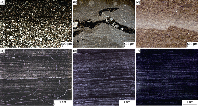
Fig. 6. SEM photos of large thin sections of the Wufeng Formation-Long 11 shale showing characteristics of gravity flow deposits. (a) Matrix-supported structure, normal graded bedding, Well H203, 3756.64 m; (b) Deformed structure, Well Zi203, 2983.40 m; (c) Scoured-filled structure, Well W201, 1497.35 m; (d) Graded bedding, Well N212, 2065.01 m; (e) Wavy bedding, Well Y101H3-8, 3757.66 m; (f) Wavy bedding, Well Y101H3-8, 3759.27 m. |
The gravity flow deposits in the Wufeng-Longmaxi formations are dominated by overflow deposits which are mainly low-density debris flow deposits and subdivided into surge-type and super-circulation-type turbidity current deposits. The surge-type turbidity current deposits are distributed at the top of Long 111. They are upward-fining, and mainly develop in the upper Ta, Tb and Tc of Bouma sequence. The super-circulation-type turbidity current deposits are distributed in the middle and bottom of Long 111. They are upward-coarsening, and have horizontal lamina at the bottom, wavy bedding in the middle and horizontal lamina at the top, and usually develop in the Tb, Tc and Td of Bouma sequence.
4. Distribution of sedimentary facies
4.1. Single-well facies
Analysis of single-well sedimentary facies is the basic work for dividing sedimentary facies, and acts as an essential precondition for well-tie and plane facies analysis. This paper analyzes the sedimentary microfacies in Wells W202 and L206 (Fig. 7 ).
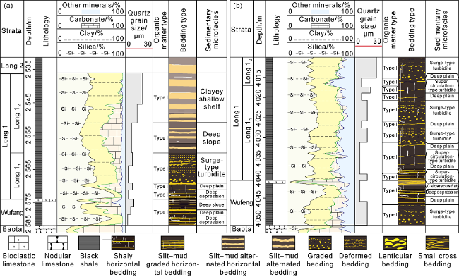
Fig. 7. Sedimentary microfacies of the Wufeng Formation-Long 11 in (a) Well W206 and (b) Well L202. |
4.1.1. Well W202
Well W202 in the Weiyuan area was drilled to the Baota Formation. It encountered about 49.5 m Wufeng Formation-Long 1 Member at 2532.4-2582.0 m. The Wufeng Formation is in parallel unconformity contact with its underlying Baota Formation, and in parallel conformity contact with its overlying Longmaxi Formation (Fig. 7 a).
The Wufeng Formation was drilled at 2574-2582 m, and composed of black shale except for 0.5 m thick bioclastic limestone at the top. Its bottom at 2578.5-2582.0 m is deep depression shale characterized by high content of silica (avg. 74.2%), low contents of clay minerals (avg. 14.2%) and carbonate minerals (avg. 5.6%), and fine grains (avg. less than 3.9 μm). Shaly horizontal bedding is found. The average TOC is 2.6%, and the organic matter is dominantly type I kerogen. The middle part at 2574.0- 2578.5 m is deep plain-deep depression shale with more carbonates (avg. 28.1%), more clay minerals (avg. 25.7%), less silica (avg. 41.5%) and coarser grains (smaller than 12.7 μm on average). There are more silty lamina, silt-mud graded and shaly horizontal beddings. The average TOC is 1.9%, and the organic matter is dominantly type I kerogen.
Long 111 is 100% black shale drilled at 2560-2574 m. The deep depression deposits drilled at 2571.5-2574.0 m have the average contents of silica, clay minerals and carbonates of 75.1%, 14.7% and 8.5% respectively; they consist of fine grains (less than 3.9 μm), with shaly horizontal bedding, average TOC of 9.4%, and organic matter dominated by type I kerogen. The deep slope-deep plain deposits drilled at 2568.5-2571.5 m have less silica (avg. 45.3%), and more clay minerals (avg. 23.2%) and carbonates (avg. 27.9%); they consist of coarser grains (greater than 13.2 μm on average), with silt-mud graded horizontal bedding, average TOC of 4.3%, and organic matter dominated by type I kerogen. The overflow deposits drilled at 2560.0-2568.5 m have silica, clay minerals and carbonates of 53.8%, 36.7% and 8.2% respectively, with the average grain size of 9.6 μm, average TOC of 3.4%, and organic matter dominated by type I kerogen. Graded bedding and deformed bedding are observed.
Long 12 is 100% black shale drilled at 2537.4-2560 m. The deep slope deposits drilled at 2549.5-2560.0 m have silica of 39%, clay minerals of 31%, carbonates of 28.5% and average grain size of 9.3 μm. The average TOC is 3.2%, and the organic matter is dominantly type I kerogen. Silt-mud alternated horizontal bedding is observed. The clayey shallow shelf deposits drilled at 2537.4-2549.5 m have silica of 43.7%, clay minerals of 50.9%, carbonates of 4.6% and average grain size of 17.5 μm. The average TOC is 2.3%, and the organic matter is dominantly type I kerogen. Silt-mud alternated horizontal bedding is found.
4.1.2. Well L206
Well L206 located in the Luzhou area was completed to the Baota Formation. It encountered about 33.8 m Wufeng Formation-Long 11 at 4017.0-4051.8 m. The Wufeng Formation is in parallel unconformity contact with its underlying Baota Formation, and in parallel conformity contact with its overlying Longmaxi Formation (Fig. 7 b).
The Wufeng Formation was drilled at 4040.8-4051.8 m, and composed of black shale except for 0.5 m thick limestone at the top. Its bottom at 4046.2-4051.8 m is composed of overflow deposits with average content of clay minerals of 42.5% and average grain size of 12.5 μm. It has normal graded bedding, average TOC of 2.6%, and organic matter dominated by type I kerogen. Its middle part at 4041.3-4046.2 m is deep plain-deep depression deposits with relatively less carbonates (avg. 13.4%) and clay minerals (avg. 30.5%), more silica (avg. 59.5%) and finer grains (smaller than 6.4 μm on average). Silt-mud graded bedding and shaly horizontal bedding are found. The average TOC is 2.6%, and the organic matter is dominantly by type I kerogen. The high abundance of carbonates in the 0.5 m thick shale at the top of the Wufeng Formation reflects a calcareous flat sedimentary environment.
Long 111 is 100% black shale drilled at 4017.0-4040.8 m. The deep plain deposits drilled at 4031.5-4040.8 m have two interlayers of gravity flow deposits. Their average contents of silica, clay minerals, carbonates, and shale grain size are 58.5%, 29.2%, 12.7% and 6.5 μm, respectively. They have shaly horizontal bedding, average TOC of 4.2%, and organic matter dominated by type I kerogen. The gravity flow deposits drilled at 4020.8-4031.5 m have relatively less silica (avg. 52.3%) and carbonates (avg. 5.1%), and more clay minerals (avg. 49.2%), and coarser grains (less than 13.5 μm). They have graded and deformed beddings, average TOC of 2.9% and organic matter dominated by type I kerogen. The deep plain deposits drilled at 4017.0-4020.8 m have thin layers of gravity flow deposits. Their average contents of silica, clay minerals and carbonates are 52.8%, 43.2% and 16.7%. Their average grain size is 8.9 μm, and average TOC is 2.3%. They have shaly horizontal bedding, and organic matter dominated by type I kerogen.
4.2. Well-tie facies
On the basis of single-well facies analysis, the scale and horizontal variation of sedimentary microfacies were determined by well-tie facies correlation for Wells WJ1, Zu206, R203, L208, H205 and JYT1 (Fig. 8 ).
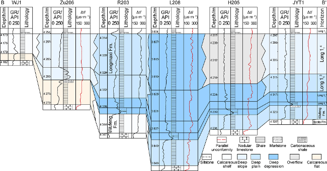
Fig. 8. Well-tie facies correlation of the Wufeng Formation-Long 11 crossing Well WJ1-Well JYT1 in southern Sichuan Basin. GR—natural gamma; Δt—interval transit time. |
The well-tie section located at the middle of the study area crosses the southern Sichuan Basin from north to south, and is between the Baota Formation and Long 12 vertically. The correlation involves the Wufeng Formation and Long 111-4. Well L208, included in this section, is located at the depocenter from which formations thin out towards south and north, resulting in missing Long 111-2 in Well Zu206 and Long 111-3 in Well WJ1 to its north.
The Wufeng Formation is tidal flat deposits in wells WJ1 and Zu206, shallow shelf deposits in Well R203, and deep plain deposits in wells L208 to JYT1, indicating deeper water in the south and shallower water in the north of the study area during its depositional period. When Long 111-2 deposited, the study area was covered by deep depression deposits. When Long 113 deposited, the depocenter was located near wells L208 and H205, and the water depth declined gradually toward north and south. Long 113 drilled by Well JYT1 in the south and Well R203 in the north is deep plain deposits, and Long 113 drilled by Well Zu206 is deep slope deposits. When Long 114 deposited, the depocenter remained near Wells L208 and H205. Long 114 is deep depression deposits in Well L208, gravity flow deposits in Well H205, deep slope deposits in Well JYT1 in the south and Well Zu206 in the north, and shallow shelf deposits in Well WJ1.
4.3. Plane distribution of sedimentary microfacies
After a systematic study, the distribution of topographic breaks, contours of carbonate content, silica content, clay minerals content and siltstone content, and plane distribution of formation thickness of the Wufeng Formation-Long 11 were mapped. Based on the maps, the area with silt-size grains accounting for over 50% is classified into underwater distributary channel, that with silt-size grains accounting for 30%-50% is interdistributary bay, that with clay mineral content higher than 50% is clayey flat, that with silica content higher than 55% is deep depression, and that with clay minerals content higher than 35% is gravity flow. When mapping the sedimentary microfacies, the distributions of three topographic breaks and shale thickness were fully considered.
During the deposition of Wufeng Formation-Long 11, the southern Sichuan Basin was in a tectonic setting of foreland basin [37]. The Leshan-Longnüsi uplift was developed in the northwest (Fig. 9 ), and the Central Guizhou-Xuefeng uplift was developed in the south, which includes two geomorphic units, namely kernel and slope [36]. The Wufeng Formation-Long 11 was completely denudated in the kernel, but remained intact in the slope.
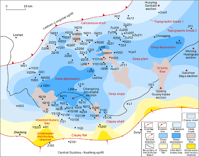
Fig. 9. Plane distribution of sedimentary microfacies of the Wufeng Formation-Long 11 in southern Sichuan Basin. |
For the Leshan-Longnüsi uplift, the kernel is located to the northwest of the WS1-W201-WJ1-Huangying Sanbaiti section belt, while the slope extends towards the southeast to the Yi201-L202-L208-TH1 belt. For the Central Guizhou-Xuefeng uplift, the kernel is located to the south of the Zhaotong-Z103-Z101-Zunyi belt, and the slope extends towards the north to the N211-H206- Wulong Huangcao section belt. From the kernel to the depression zone, there are three large topographic breaks.
Delta, tidal flat and shelf facies have been identified in southern Sichuan Basin. Delta and tidal flat are developed at the edges of the Central Guizhou-Xuefeng uplift. The delta facies is found in Wells YS201 and YS207 and the southeastern study area, and it extends into the basin from south to north. The tidal flat facies is distributed between deltas, with a high content of clay minerals. The shelf facies is distributed in the slope zone of the uplift, and it is subdivided into shallow shelf and deep shelf subfacies. The deep shelf subfacies, including deep slope, deep plain and deep depression microfacies, is found in the front of the shallow shelf. The deep depression microfacies is distributed along wells L202-Yi201-N211, L208 and TH1, and generally surrounded by the deep plain and deep slope microfacies. The slope is steep from the deep slope to the deep plain. Sliding collapse is easy to occur in the delta front, forming gravity flow deposits.
Controlled by sources, different zones develop various microfacies within the southern Sichuan Basin. With insufficient supply of sediments to the north, the shale has high content of calcium, leading to the dominance of calcareous shelf microfacies in the shallow shelf subfacies. The sufficient supply of sediments to the south allowed the development of clayey flat microfacies in the tidal flat facies and clayey shelf microfacies in the shallow shelf subfacies.
4.4. Distribution models of sedimentary microfacies in the epicontinental shale
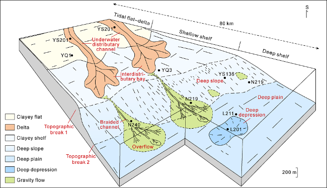
Epicontinental sea was widely distributed in the geological history, and characterized by a gentle slope, shallow water and a large area. In the case of insufficient supply of terrigenous sediments, the epicontinental sea mainly developed clear-water carbonate deposits, while in the case of adequate supply of terrigenous sediments, developed muddy-water fine-grained clastic deposits. The Wufeng Formation-Long 11 interval was formed in the epicontinental sea (Fig. 10 ). It is mainly composed of black shale with sufficient terrigenous supply.
Fig. 10. Distribution models of sedimentary facies in the Wufeng Formation-Long 11 epicontinental shale in southern Sichuan Basin. |
The sedimentary environments of fine epicontinental clastic rock were mainly tidal flat and continental shelf. The delta deposits were formed in the coastal zone with terrigenous input, and the gravity flow deposits were formed in the deep slope as the result of sliding collapse of delta front deposits. Because of topographic fluctuation, different supply of sediments and variable transport pathway, sedimentary facies developed in the epicontinental sea can be subdivided into different subfacies and microfacies. Specifically, underwater distributary channel and interdistributary bay microfacies under delta front subfacies, calcareous flat and clayey flat microfacies under intertidal flat subfacies, calcareous shelf and clayey shelf microfacies under shallow shelf subfacies, and deep slope, deep plain and deep depression microfacies under deep shelf subfacies were subdivided.
From the coastal zone to the depocenter, sediment supply decreased and transport distance increased, resulting in the variation of grain size from coarse siltstone to fine mudstone and increased proportion of fine mudstone. Meanwhile, the contents of carbonates and clay minerals declined, and the silica content increased.
The formation of epicontinental fine clastic rock was closely related to the active tectonic setting, warm and humid paleoclimate, and rapid rise of the sea level. When the Baota Formation deposited, the Yangtze epicontinental sea mainly developed clear-water deposits and extensive carbonate platforms because of rare sediment supply and stable peripheral plates. Strengthened tectonic activities and frequent volcanic activities in the peripheral plates when the Wufeng Formation deposited increased the supply of terrigenous clasts, forming massive muddy-water fine clastic rock. From the Wufeng Formation to the Longmaxi Formation, the southern Sichuan Basin was on a tropical-subtropical environment. Warm and humid paleoclimate [6,20], water dominated by laminar flow [14] and low oxygen content led to abundant organic matter in the shale [18]. Moreover, the rapid rise of sea level reduced the depositional rate (0.5-31.2 m/Ma [40]), and contributed to the wide distribution of black shale.
5. Conclusions
The epicontinental sea developed delta, tidal flat and shelf facies, with black shale deposited in the underwater distributary channel and interdistributary bay under delta front subfacies, the calcareous and clayey flats under intertidal flat subfacies, the calcareous and clayey shelves under shallow shelf facies, the deep slope, deep plain and deep depression under deep shelf facies, and the overflow under gravity flow facies.
Toward the basin, silty lamina decreases and muddy lamina increases, the grain size changes from coarse siltstone to fine mudstone, the siliceous content increases from about 20% to above 55%, the carbonate and clay minerals decreases from above 40% to around 10%, and the kerogen type changes from type II2 to types II1 and I.
Source and topography controlled the types and distribution of the shale microfacies. The underwater distributary channel, interdistributary bay, clayey flat, clayey shelf, and overflow microfacies were developed in areas with sufficient sediment supply. The calcareous flat and calcareous shelf were developed in areas with insufficient sediment supply. The deep shelf shale area was divided into deep slope, deep plain, and deep depression as a result of three breaks.
The formation of the epicontinental shale with different microfacies was closely related to the tectonic setting, paleoclimate, and the rise of sea level. The active tectonic setting increased the supply of terrigenous clasts, and brought fine muddy water sediments. The warm and humid paleoclimate was conducive to the enrichment of organic matter. The rapid rise of sea level was helpful to the widespread black shale.