

Introduction
Paleo-uplifts refer to the relative uplift structures of different periods and different genesis in geological history [1]. Due to the influence of tectonic movements in different periods, different paleo-uplifts usually develop in different evolutionary stages of a basin, and the paleo-uplifts might generally migrate and evolve with the evolution of the basin [2]. Paleo-uplifts play an important role in controlling the deposition and later denudation of reservoirs, the formation of traps, and the later transport and preservation of oil and gas in a basin [3]. Paleo-uplifts are often favorable areas for oil and gas accumulation because they are located in high tectonic parts with low fluid potential and developed reservoir and transport systems [4-5], especially some large and long developed paleo-uplifts are more conducive to oil and gas enrichment [6]. Therefore, the study on the evolution and migration of paleo-uplifts can well define the transport process of oil and gas and discover favorable oil and gas accumulation sites, which can guide oil and gas exploration. The formation and migration of paleo-uplifts can often reflect the tectonic evolution of the basin and the peripheral orogenic belts, so the study on the evolution of paleo-uplifts is of great significance for the evolutionary analysis of the peripheral orogenic belts.
The Tarim Basin has a long history of tectonic evolution, and a series of paleo-uplifts have developed during its evolution. In the southwestern Tarim Basin (referred to as TXN), He et al. [7] proposed in 1996 that there developed an Early Paleozoic paleo-uplift (TXN paleo-uplift) which was formed in the Sinian period and evolved to the late Early Paleozoic. Its formation was related to the warping and denudation of the shoulder of the North Kunlun Rift during the breakup of the Tarim Craton. Zhao et al. [8-9] considered the TXN paleo-uplift to be an extinct paleo-uplift. Wu et al. [10] considered that the TXN paleo-uplift was formed in the Early Ordovician, adjusted and modified from the Late Ordovician to the Devonian, and almost shaped during the Carboniferous period. Its formation was controlled by the Precambrian basement uplift in the Tarim Basin.
Meanwhile, Yang et al. [11] proposed in 1996 that another paleo-uplift (Hetian Paleo-uplift) was developed in the Tarim Basin during the Early Paleozoic. Huang et al.[12] suggested that the Hetian paleo-uplift was an east-west trending paleo-uplift in the Caledonian cycle, and formed during the early Hercynian cycle due to the south-eastward extrusion. Sun et al. [13] suggested that the extrusion at the end of the Caledonian cycle resulted in the uplift and denudation of the early Middle Ordovician-Devonian deposits, thus forming the Hetian paleo-uplift.
Previous studies have suggested that there were TXN paleo-uplift [7⇓⇓-10] and Hetian paleo-uplift [11⇓-13] in the Silurian TXN region. However, from the published results, they are temporally similar and spatially overlapping. So, they have the following three scientific questions that deserve further investigation: (1) Are the two uplifts completely independent or the same paleo-uplift in different evolutionary stages? If they are the same uplift shown in different evolutionary stages, how did the paleo-uplift evolve in time and how did it migrate spatially? (2) What are the tectonic properties of the late Early Paleozoic paleo-uplift in TXN? And what’s the orogenic process of the peripheral orogenic belts reflected with its migration? (3) How did the formation and migration of the late Early Paleozoic paleo-uplift in TXN control the development of the upper clastic reservoirs and the formation of the fractured-vuggy reservoirs in the carbonate weathered crust?
In order to investigate the above three scientific questions, on the basis of the calibration of well tops, regional 2D seismic profiles and 3D profiles in key exploration blocks were used to identify the paleo-uplift. And based on 2D seismic interpretation for the whole TXN area, the ancient plane morphology maps of the dolomite top underlying the Cambrian salt formation in different periods were compiled to reflect the spatial spread and migration style of the paleo-uplift. The regional geological framework was constructed to analyze the development characteristics and evolution of the paleo-uplift in details. On this basis, the tectonic attributes of the late Early Paleozoic paleo-uplift were determined and the effects of its migration and evolution on the early Paleozoic orogenic process in West Kunlun and its controlling effect on reservoir development were discussed in the context of the Early Paleozoic evolution of the West Kunlun orogenic belt in the TXN, so as to reveal the early Paleozoic evolution and prototype of the Tarim Basin and support oil and gas exploration in the Lower Paleozoic of TXN.
1. Geological setting
The Tarim Basin is a typical large superimposed and composite basin developed on the top of the Precambrian basement [14]. The formation of the metamorphic basement was mainly associated with several tectonic events taking place before 2.45-2.65, 1.8-2.0, and 0.9-1.1 Ga, respectively [15⇓-17]. During the Late Neoproterozoic, an NE intra-continental rift system and an NW southwest continental margin rift system developed in the Tarim Basin under the influence of the breakup of the Rodinia supercontinent [18]. Early Paleozoic tectonic events had a very important impact on the Tarim Basin, resulting in the formation of several paleo-uplifts and fold and thrust belts in the basin, such as the Manan fold and thrust belt. These paleo-uplifts controlled the deposition and later denudation of the Ordovician, Silurian, Devonian, and Carboniferous formations, and Silurian oil and gas accumulation. Jia et al. suggested that oil and gas accumulation in the Paleozoic Craton Basin was influenced by the paleo-uplifts and their slope zones [19-20].
As a unified dynamical system with close connection in spatial and temporal development and formation mechanisms, the basin formation was controlled by the peripheral orogeny, while the deformation and deposition of the basin recorded the process of basin marginal orogeny. The Early Paleozoic tectonic evolution of the Tarim Basin was closely related to the peripheral orogenic belts. In the southwest of the Tarim Basin, the West Kunlun orogenic belt was developed, which is a composite orogenic belt and can be divided into a North Kunlun Block, a South Kunlun Block and a Tianshuihai Block, separated by two suture lines. In the north it is the late Early Paleozoic orogenic belt represented by the Kudi-Qimanyute ophiolite belt, and in the south it is the Early Mesozoic orogenic belt represented by the Maza-Kangwaxi-Subashi ophiolite belt. They represent the Proto-Tethys Ocean (Paleo-Kunlun Ocean) and the Paleo-Tethys Ocean tectonic cycles respectively. The West Kunlun region was characterized by multiple oceanic islands during the Early Paleozoic, and several small blocks with the Precambrian crystalline basement within the West Kunlun orogenic belt were split from the Tarim Craton [21]. Zhang et al. suggested that the southwestern margin of the Tarim plate (also called the North Kunlun Block) collided with the South Kunlun Block from about 440 Ma to 450 Ma, and a foreland basin developed on the southwestern margin of the Tarim Craton [22].
The TXN region consists of three tectonic units: the Bachu Uplift, the Southwest Depression and the West Kunlun Frontal Thrust Belt. The Southwest Depression includes the Kashi Sag, the Yecheng Sag and the Maigaiti Slope (Fig. 1 a). The Early Paleozoic sedimentation in the TXN has undergone important changes in the Middle Ordovician. The Cambrian to the Early Ordovician is dominated by marine carbonate sediments, and the Lower Cambrian is phosphate-bearing deep-water dark mudstone which is one of the most important hydrocarbon source rocks in the Tarim Basin [23]. However, the Middle Ordovician in some areas did not receive sediments affected by tectonic events, and instead continent clastic sediments began to appear from the Upper Ordovician, and denudation happened in some areas (Fig. 1 b).
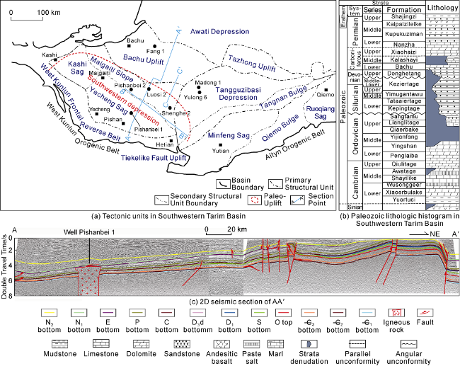
Fig. 1. Tectonic units and regional seismic section in the southwestern Tarim Basin. N2—Pliocene; N1—Miocene; E—Paleogene; P—Permian; C—Carboniferous; D3d—Upper Devonian Donghetang Formation; D1—Lower Devonian; S—Silurian; O—Ordovician; —C3—Upper Cambrian; —C2—Middle Cambrian; —C1—Lower Cambrian. |
2. Identification of Early Paleozoic paleo-uplift in TXN and its basic characteristics
In the process of geological evolution, paleo-uplift often suffers from strong denudation, resulting in unconformable contact with the overlying strata and onlap in the overlying strata. Therefore, the existence and development characteristics of the paleo-uplift can be identified through the analysis of the unconformity and onlap in seismic profiles.
The pre-Carboniferous geological map of TXN (Fig. 2 a) shows that the Silurian to the Middle-Lower Devonian is missing in a large range near the Hetian area, indicating a large paleo-uplift in TXN. The interpretation result of the 2D seismic profile of BB° leveled at the bottom of the upper clastic rock of the Permian Aqia Group (Fig. 2 b) shows that the Upper Ordovician in the whole section has been denudated except for a small amount of the Upper Ordovician on the right of the section. The Siluran-Devonian on the left of the section overlies the Middle-Lower Ordovician on the right, and its thickness gradually decreases toward the right, indicating that there was once an uplift zone on the right of the section. The Carboniferous has covered the whole section, with relatively stable thickness, indicating that the uplift zone no longer exists at the location of the section. In addition, it can be seen from the section that faults cut through the Ordovician on the right side and are downward to the Middle Cambrian gypsum-salt layer, which control the deformation of the Cambrian-Ordovician, and the Carboniferous unconformably overlaid these strata, indicating that a strong tectonic deformation event occurred in this area after the Upper Ordovician deposition.
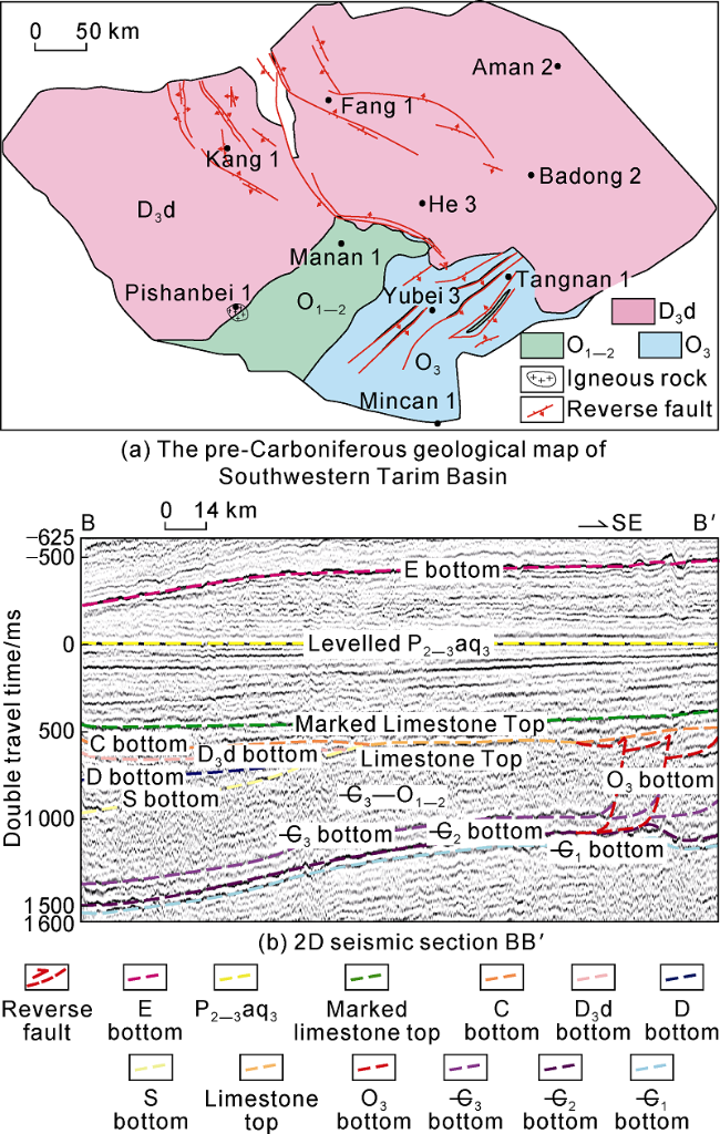
Fig. 2. Paleogeological map of Pre-Carboniferous in the southwestern Tarim Basin and interpretation section leveled by the bottom of upper rock of the Permian Aqia Group (see |
In order to further reveal the characteristics of the uplift zone, several 2D seismic profiles from the Kunlun Mountains to the Awati Depression were selected and merged together to a regional framework near northeast-southwest trending. From south to north, the framework passes through the West Kunlun Frontal Thrust Belt, the Yecheng Sag, the Maigaiti Slope, the Bachu Uplift and the Awati Depression. Sections AA' and CC' were selected for identifying the paleo-uplift.
The thickness from the Upper Cambrian to the Middle and Lower Ordovician is generally uniform, and only slightly decreases toward southwest (Fig. 1 c). The thickness of the Upper Ordovician decreases sharply toward southwest, and denudation occurred, indicating that the Upper Ordovician was uplifted and denuded after deposition. The thickness of the Silurian decreases significantly toward southwest and pinched out at Well Pishanbei 1 (Fig. 1 c). According to the depositional relationship, the Silurian gradually onlapped on the section, namely the Silurian onlapped on the underlying strata. The Devonian also onlapped on the underlying strata, but the pinch-out position is further to the left of the section, indicating that the Devonian has a larger sedimentary range than the Silurian. The Carboniferous system is developed throughout the section, and the thickness is basically the same, with only a slight thinning on the left side of the section. The stratigraphic characteristics of this section indicate that there is a paleo-uplift which was initially formed at the end of the Middle Ordovician and had an important control on the deposition of the Upper Ordovician to the Devonian, until the Carboniferous.
3. Migration and evolution of the Early Paleozoic paleo-uplift in TXN
3.1. Restoration of denuded thickness and original depositional thickness and the development of paleo-uplift
In the long evolution process of the paleo-uplift, there were multi-stage tectonic events and multi-stage denudation, which changed the original sedimentary and deformed states of the basin, therefore greatly increasing the difficulty in the study of the tectonic evolution history about the paleo-uplift. The restoration of denuded thickness in each deformation period is the premise of studying the tectonic evolution of the paleo-uplift.
There are many methods to restore the denuded thickness, such as thickness tendency, well logging, thermal index and depositional rate, among which the most commonly used method is the thickness tendency. It is usually considered that the strata are continuously deposited laterally, so the original depositional thickness is also continuous and has a certain spatial trend. Therefore, the denuded thickness can be restored based on well and seismic data as well as the thickness of the uneroded strata in the neighboring area. To verify the correctness of the restored thicknesses, the Permian thicknesses obtained by the thickness tendency method in the Yubei area of the Tarim Basin was compared with the Permian thicknesses calculated by You [24] using the method of acoustic time difference and Cai [25] using the method of vitrinite reflectance and acoustic time difference. The results are basically consistent.
Using the thickness tendency method, the denuded thickness of each stratum in TXN caused by tectonic events in each stage and the total amount of denudation caused by multiple stages of tectonic events were restored. Combined with the residual thickness maps of different strata, the original thickness maps of different periods in TXN were compiled (Fig. 3 ) to help analyze the tectonic evolution process of the paleo-uplift in TXN.
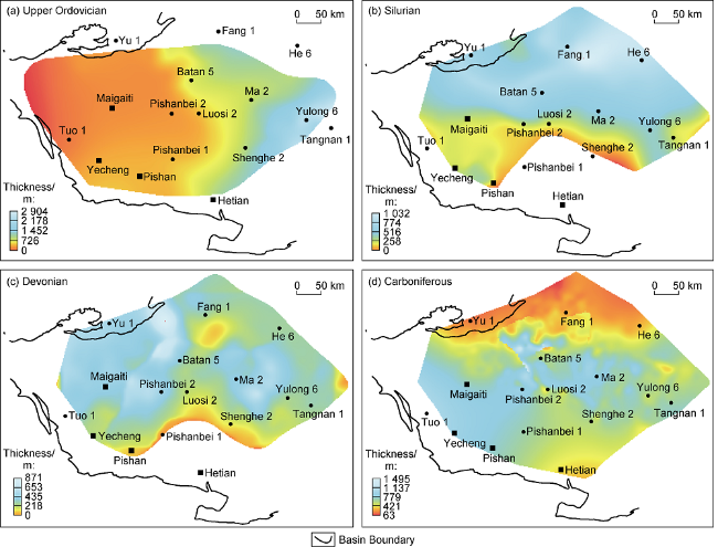
Fig. 3. Original thickness maps of Upper Ordovician, Silurian, Devonian, and Carboniferous in the southwestern Tarim Basin. |
The Upper Ordovician sedimentary thickness shows thin deposits in southwest and thick deposits in northeast, and overall thickening toward northeast (Fig. 3 a). The depositional thickness shows an obvious spatial variability, ranging from 350 m in Well Pishanbei 1, to 950 m in Well Shenghe 2, to nearly 2000 m in Well Yulong 6.
The Silurian is missing in the Hetian area in the southern Tarim Basin. The pinch-out line is roughly along Well Pishanbei 1 to Well Shenghe 2. No Silurian deposit was found in the south (Fig. 3 b). The extent of the missing area roughly covers the extent of the original paleo-uplift. The Silurian sedimentary zone is on the north of the pinch-out line, about 200 m in Well Pishanbei 2 and Well Luosi 2, and up to 1000 m in Well Fang 1 to the north.
The sedimentary range of the Devonian slightly expands to south than the Silurian, and the missing extent is smaller than the Silurian (Fig. 3 c). For example, Well Shenghe 2 goes from no Silurian (Fig. 3 b) to about 150 m Devonian (Fig. 3 c), which shows that the depositional range of the Devonian is larger than that of the Silurian. The phenomenon can be recognized on the seismic section (Fig. 1 ). The thickness trend of the Devonian is similar to that of the Silurian.
Compared with the Silurian and the Devonian, the Carboniferous has a broader range. It deposited at the highest point of the paleo-uplift. The Carboniferous on the whole shows slight thinning to south in TXN. At that time, the paleo-uplift had disappeared and the sedimentary control of the carboniferous was weak (Fig. 3 d).
3.2. Ancient plane morphology maps of the dolomite top below the Cambrian salt layer and spatio-temporal migration of the paleo-uplift
In order to study the spatio-temporal migration of the paleo-uplift in TXN, based on the recovery of the denuded thickness in each period of tectonic events, taking the dolomite top below the Cambrian salt layer with relatively stable sequence development and a clear seismic reflection interface as the object, and combined with the residual thickness of each stage, the ancient plane morphology maps of the dolomite top below the Cambrian salt layer in each period were prepared by using Doublefox software (Fig. 4 ). The spatial migration and temporal evolution of the paleo-uplift were analyzed intuitively according to the changes of the tectonic morphology of the dolomite top below the Cambrian salt layer. Fig. 4 a-4f show the ancient plane morphology maps of the dolomite top below the Cambrian salt layer during key tectonic events, including the end of the Middle Ordovician, the end of the Late Ordovician, the end of the Silurian, the end of the Middle Devonian, the end of the Devonian, and the end of the Carboniferous, respectively.
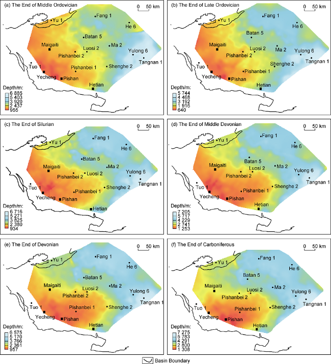
Fig. 4. Ancient plane morphology maps of the dolomite top below the Cambrian salt layer at different stages in the southwestern Tarim Basin. |
At the end of the Middle Ordovician, the dolomite top below the Cambrian salt layer showed a pattern of high in front of the West Kunlun Mountains in the southwest margin and low in the Maigaiti Slope in the northeast, and there was an uplifted zone. Combined with the section characteristics, it can be considered that a large range of low-amplitude paleo-uplift was formed in TXN at that time (Fig. 4 a).
At the end of the Late Ordovician, the dolomite top below the Cambrian salt layer in the whole TXN further elevated, and the paleo-uplift zone further expanded. Combined with the analysis of regional sections, it can be concluded that the low-amplitude paleo-uplift of the Middle Ordovician had become a regional paleo-uplift in the Late Ordovician. According to the morphological analysis of the dolomite top below the Cambrian salt layer, there were two secondary-order tectonic highs in the uplift at that time. The tectonic high in the western part of the Maigaiti Slope was located inside the West Kunlun, while the other tectonic high was near Yecheng (Fig. 4 b).
By comparing the regional sections, we can find that the deformation at the end of the Late Ordovician was spatially heterogeneous, and there was a great difference in deformation in the western part of the Maigaiti Slope, the southern part of Mazatage and the eastern part of Mazatage. The western part of the Maigaiti Slope only showed overall uplift toward the West Kunlun Mountain, with the Ordovician denuded and the Silurian, Devonian and Carboniferous onlapping from north to south. The deformation in the southern and eastern Mazatage was strong thrust (Fig. 4 b).
At the end of the Silurian, the uplifting of the dolomite top below the Cambrian salt layer in TXN expanded to east, and the area covering Wells Pishanbei 1, Pishanbei 2, Shenghe 2 and Luosi 2 began to uplift. The eastward expansion of the dolomite top implies that the paleo-uplift expended to east, and the eastern area also became a part of the paleo-uplift (Fig. 4 c).
At the end of the Middle Devonian, the dolomite top was further enhanced to east compared with the Silurian period, and the tectonic high of the paleo-uplift was mainly located in the Pishan-Hetian area in the southern Tarim Basin, while the other earlier uplift high located in the northwest disappeared. It fully reflects the eastward migration and enhancement of the paleo-uplift (Fig. 4 d).
At the end of the Devonian, the uplift range of the dolomite top started to gradually decrease, and the uplift area was developed only in the southern Tarim Basin. The tectonic high of the uplift was located around Well Pishanbei 1 and its southwest. It was only a small paleo-uplift in the southern Tarim Basin (Fig. 4 e).
At the end of the Carboniferous, the uplift pattern at the dolomite top was basically consistent with that at the end of the Late Devonian, and the tectonic high of the uplift was still located around Well Pishanbei 1 and its southwest. But the height of the paleo-uplift was significantly lower than that at the end of the Late Devonian (Fig. 4 f). The paleo-uplift at the end of the Carboniferous was already a low-amplitude uplift. Combining with BB′ section, the Carboniferous was deposited at the high of the uplift, and the paleo-uplift had become a submarine one at that time (Fig. 4 f).
Combining the morphological characteristics, migration and evolution of the dolomite top, and with the structure of the regional sections, it is clear that a paleo-uplift started to appear during the late Early Paleozoic, then it was developed at the end of the Middle Ordovician, with two structural highs, and at last in the Late Ordovician it began to take shape. The uplift was further raised, and the two highs were more prominent. In the Silurian, the paleo-uplift expanded rapidly toward east, and covered Wells Pishanbei 1, Pishanbei 2, Shenghe 2 and Luosi 2, and the structural high was located in the Pishan-Hetian area. In the Devonian, the extent of the paleo-uplift began to shrink gradually. In the Carboniferous, the paleo-uplift began to become an underwater one.
Although paleo-uplifts were identified in TXN by previous studies, the paleo-uplift revealed in this paper spatially includes the Southwest Paleo-uplift and the Hetian Paleo-uplift proposed by other authors. Based on the migration characteristics of the paleo-uplift, this paper believes that the Southwest Paleo-uplift and the Hetian Paleo-uplift proposed by other authors are the manifestations of one paleo-uplift at different regions and stages in the process of migration and evolution. The paleo- uplift mentioned by other authors can no longer be treated as two paleo-uplifts, but as one unified paleo-uplift, which is named "Southwestern Tarim Uplift".
3.3. Evolution of the "Southwestern Tarim Uplift"
In order to explore the formation and evolution of the "Southwestern Tarim Uplift", a schematic diagram of the evolution of the paleo-uplift was prepared using a northeast-southwest trending section to refine the structural and sedimentary characteristics in each evolutionary stage, so as to further analyze the early Paleozoic evolution process of the paleo-uplift (Fig. 5 ). In order to study the migration and evolution on plane, a planar migration diagram of the paleo-uplift was compiled (Fig. 6 ).
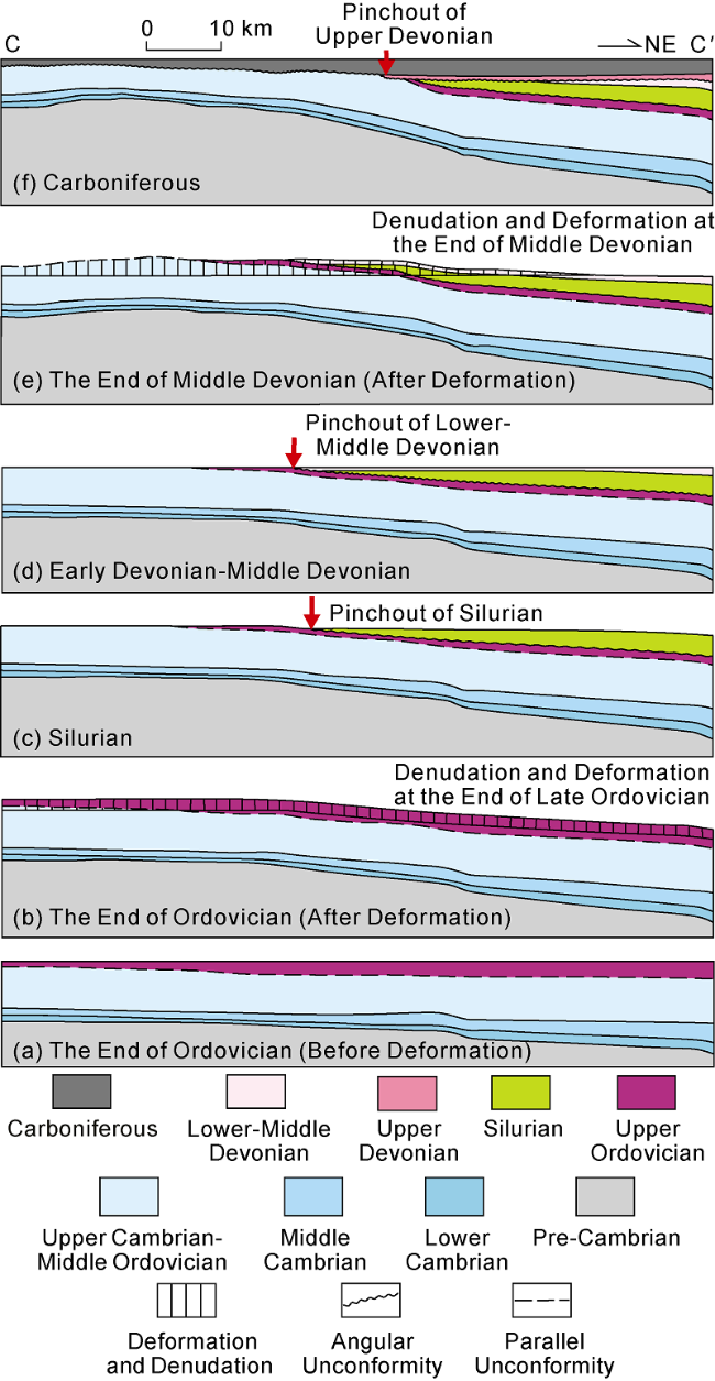
Fig. 5. Schematic evolution process of the Southwestern Tarim Paleo-uplift (see |
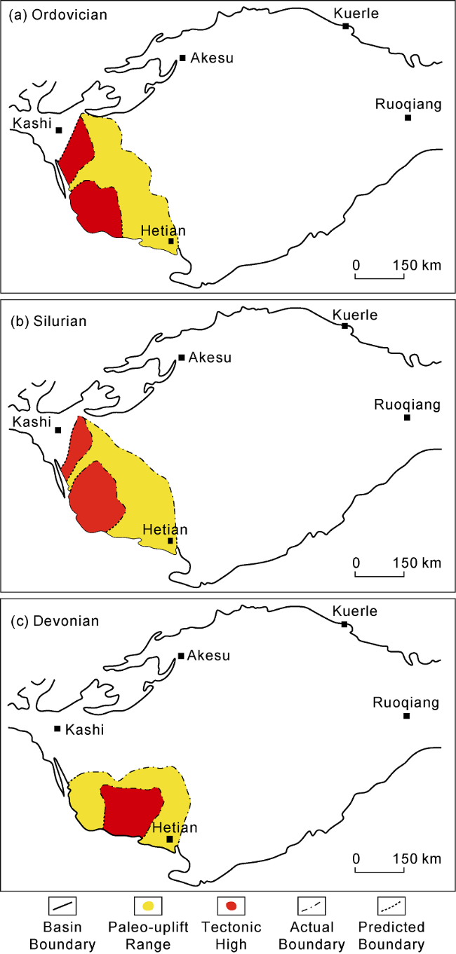
Fig. 6. Planar migration of the Southwestern Tarim Paleo-uplift. |
In TXN, the Cambrian of the Phanerozoic deposited on top of the Sinan, and there was a parallel unconformable contact between them. At the end of the Middle Ordovician, under the influence of the peripheral orogenic belts, TXN was uplifted as a whole, forming a regional paleo-uplift, called the Southwestern Tarim Paleo-uplift (Fig. 6 ), which led to the denudation of the Middle and Lower Ordovician and the deposition of the upper Ordovician overlying on the top of the Middle-Lower Ordovician (Fig. 5 a).
At the end of the Upper Ordovician deposition, strong tectonic uplifting resulted in the denudation of the Upper Ordovician. The denudation at the end of the Ordovician shows a trend of gradually increasing toward the south of TXN. In the CC' section, the Upper Ordovician in the northeast part shows a wedge-shaped residual pattern, and the strata indicated by the short black vertical lines are the denuded parts (Fig. 5 b). In the Late Ordovician, the Southwestern Tarim Paleo-uplift was preliminarily established, and there were two relatively high parts on the uplift (Fig. 6 ).
During the Silurian sedimentary period, under the influence of the early paleo-uplift, the sedimentary strata showed the characteristic of gradually onlapping the paleo-uplift toward south. In Fig. 5 , the yellow Silurian and the underlying strata are in onlapping contact, and the Silurian gradually is thicker toward northeast (Fig. 5 c).
During the Lower and Middle Devonian, the sedimentary strata further onlapped on the paleo-uplift, and the onlapping range was larger than that of the Silurian. The pinch-out was close to Well Pishanbei 1. At the end of the Middle Devonian, deformation occurred in TXN, resulting in a new phase of denudation. The Upper Devonian Donghetang Formation continued to onlap the paleo-uplift, when it has been stabilized. In terms of planimetric distribution, the Southwestern Tarim Paleo-uplift began to shrink and migrate toward the Pishan-Hetian areas during the Devonian period, and the high part of the paleo-uplift was located in the Pishan-Hetian areas, while the high part in the west of Hetian gradually began to die out (Fig. 6 ).
4. Discussion
In response to the scientific questions raised in the introduction, the tectonic attribute of the Southwestern Tarim Paleo-uplift, the constraints of the paleo-uplift migration and evolution on the orogenic process, and the influence of the Early Paleozoic reservoir development in TXN were thoroughly discussed and analyzed.
4.1. Tectonic attribute of the Southwestern Tarim Paleo-uplift
The orogeny of the orogenic belts around the Tarim Basin controlled the structural deformation such as thrust belts and paleo-uplifts inside the basin. In the Early Paleozoic, the evolution of the southern Tarim Basin was controlled by the orogeny of the West Kunlun orogenic belt. For the tectonic attributes of the southern Tarim Basin in the late Early Paleozoic, Wei et al. [26] proposed that a Silurian-Devonian peripheral foreland basin was developed in the southern margin of the Tarim Basin by combining the Lower Paleozoic sedimentary features inside the basin, the Early Paleozoic thrust deformation features in the southeast of the basin, and the Early Paleozoic evolutionary features of the West Kunlun orogenic belt. Zhang et al. [22] established an evolutionary model of the eastern section of the West Kunlun orogenic belt, and concluded that the Proto-Tethys Ocean between the Tarim Plate and the South Kunlun Block died out from about 440 Ma to 450 Ma, and then the two blocks collided, a peripheral foreland basin was developed in the TXN region on the side of the subducting block.
Moreover, the sedimentary characteristics of the TXN area underwent an important transformation in the Early Paleozoic, from carbonate platform facies in the Cambrian to terrigenous clastic deposits in the Late Ordovician. Lin et al. [27] suggested that the transformation in sedimentary characteristics was related to the change from ocean basin expansion to closed extrusion for the surrounding Kunlun and Altyn Oceans. Such a change in sedimentary environment also implies a possible change from the Cambrian-Early Ordovician passive continental margin to the Middle Ordovician-Middle Devonian foreland basin in the region.
A foreland basin usually has three main tectonic units, including a foreland fold and thrust belt, a foredeep and a forebulge. The forebulge is a flexural uplift zone on the craton side, which often migrates during the development of the foreland basin. It can not only migrate longitudinally from the orogenic belt side to the craton side, but also migrate laterally with the orogenic process.
The Southwestern Tarim Paleo-uplift began to form in the western part of the TXN region at the end of the Middle Ordovician. Then it expanded to the whole TXN region in the Silurian, and migrated to the Pishan-Hetian area in the southern Tarim Basin in the Devonian. The paleo-uplift is spatially adjacent to the West Kunlun orogenic belt developed at the same time. It’s developed on the side of the subducting plate during the colliding orogenic process of the West Kunlun orogenic belt. They are temporally consistent, both in the late Early Paleozoic. Therefore, the Southwestern Tarim Paleo-uplift is an important unit of the foreland basin, namely the forebulge, developed on the subducting plate (the Tarim Plate), during the collision between the Tarim Plate and the Southern West Kunlun Block in the Early Paleozoic. But, the foredeep of the foreland basin was completely transformed due to the influence of two extrusive tectonic events during the Late Triassic and Cenozoic. The large-scale advance of the West Kunlun orogenic belt into the interior of the Tarim Basin resulted into the foredeep of the Early Paleozoic foreland basin in TXN completely transformed.
4.2. Influence of the Southwestern Tarim Paleo-uplift evolution on the West Kunlun orogeny
Previous studies have shown that the formation of the West Kunlun orogenic belt in the southern Tarim Basin occurred around the Early Silurian, but the orogenic model of the West Kunlun orogenic belt is lack of relevant studies. Is the orogeny of the West Kunlun orogenic belt spatially isochronous or "scissor-like"? If it is "scissor- like", what is the process?
As a unified dynamic system,orogenic belt and basin are closely related in spatial and temporal development and formation mechanism, basin deformation and sedimentation record the process and model of orogeny at the basin margin. Therefore, the migration of the forebulge within the basin can be used to indicate the process and model of orogeny of the adjacent orogenic belt.
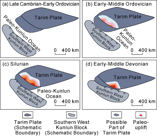
The initial development of the forebulge is often indicative of the initial collision of the surrounding orogenic belt, and the initial formation at the end of the Ordovician for the Southwestern Tarim Paleo-uplift indicates the initial collision of the Tarim Plate with the Southern West Kunlun Block. The rapid uplift and denudation at the end of the Ordovician indicates a strong collision between the Tarim Plate with the Southern West Kunlun Block (Figs. 4 and 7 ). The rapid eastern expansion during the Silurian indicates the eastward migration of orogeny between the Tarim Plate and the Southern West Kunlun Block. The migration of the paleo-uplift to the southern part of the Tarim Basin at the end of the Middle Devonian and the substantial reduction of the paleo-uplift to a small paleo-uplift in the south indicate that orogeny has migrated to the eastern part and that orogeny in the western part has been significantly weakened or stopped (Figs. 4 and 7 ). This spatially eastward migration of the Southwestern Tarim Paleo-uplift reflects that the orogeny of the West Kunlun orogenic belt probably proceeded in a "scissor-like" pattern from west to east.
Fig. 7. Schematic diagram of West Kunlun orogeny process based on the migration of Southwestern Tarim Paleo-uplift. |
In summary, the orogeny of the Early Paleozoic West Kunlun orogenic belt in the southern Tarim Basin started from the western part of the orogenic belt, and the initial collision started at the end of the Middle Ordovician. And the orogeny was intensified at the end of the Late Ordovician. The orogeny of the Silurian West Kunlun orogenic belt has extended to the eastern part of the West Kunlun orogenic belt. The orogeny of the Early-Middle Devonian West Kunlun orogenic belt mainly occurred in the eastern part of the West Kunlun orogenic belt. And the orogeny of the West Kunlun orogenic belt ended during the Late Devonian. The orogeny of the West Kunlun orogenic belt began in the western section at the end of the Middle Ordovician and proceeded in a "scissor-like" pattern from west to east (Fig. 7 ).
4.3. Influence of the Southwestern Tarim paleo-uplift migration and evolution on Early Paleozoic reservoir development in TXN
TXN is a very important oil and gas exploration area in the Tarim Basin, where four oil and gas reservoirs have been discovered [28-29]. From the perspective of stratigraphy, the Cambrian-Ordovician and Carboniferous are the key target formations which have huge remaining oil and gas resources, and are the hot spots for increasing deep oil and gas reserves [30-31]. The upper part of the Middle-Upper Ordovician is an epigenetic weathered karst reservoir [32⇓-34], and the best reservoir in TXN.
The development of the paleo-uplift led to the uplift and denudation of the strata, and the paleo-weathering crust and paleo-karst formed at the top of the paleo-uplift below the unconformity, which are good fractured-vuggy reservoirs. Meanwhile, the dissolution pores and caves induced by exposure and denudation made the interval with poor permeability become better transport channels.
The development of the Southwestern Tarim Paleo- uplift and its migration has led to different periods of unconformities in different locations. In the early stage, uplift and denudation mainly occurred in the western region, and formed two phases of unconformities, i.e., at the end of the Middle Ordovician and at the end of the Ordovician, and the weathered crust below the unconformities was developed in carbonate rock, thus forming two phases of paleo-karst, with fractured-vuggy reservoirs below the unconformities. According to the evolution of the paleo-uplift, these two sets of fractured-vuggy reservoirs are mainly distributed in the western part of the present Maigaiti Slope. They are the most favorable exploration targets in the western part of the Maigaiti Slope.
Under the influence of paleo-uplift migration, the fractured-vuggy reservoirs in the eastern part of the Maigaiti Slope and the southern part of Tangguzibasi show large differences. Strong uplift in the eastern part of TXN occurred at the end of the Late Ordovician and the end of the Middle Devonian, forming two phases of unconformities. The weathered crust under the unconformity developed at the end of the Ordovician was developed in carbonate rock, and could form regional fractured-vuggy weathered crust reservoirs. However, the weathered crust under the unconformity developed at the end of the Middle Devonian was influenced by denudation intensity. The weathered crust in the area with high denudation intensity may be in carbonate rock and form paleo-karst, while in the northern area with low denudation intensity, it may be in clastic rock and can’t form karst reservoirs. The fractured-vuggy reservoirs under the Middle Devonian unconformity do not have regional characteristics. In conclusion, the migration and evolution of the paleo-uplift control the spatial variability of the Early Paleozoic fractured-vuggy weathered crust reservoirs.
The spatial migration of the Southwestern Tarim Paleo-uplift also constrains the oil and gas exploration direction. It is generally believed that the high part of the paleo-uplift is the area with the strongest weathering and denudation, which means that the area with the most developed fractured-vuggy reservoirs, and it is the focus of oil and gas exploration. However, the tectonic high of the uplift has been relocated during its evolution. There were two secondary uplift highs at the end of the Ordovician: the tectonic high in the western part of the Maigaiti Slope was located inside the West Kunlun, while another tectonic high was near Yecheng (Fig. 4 b). But to the end of the Middle Devonian the tectonic high was almost located in the Pishan-Hetian area in the southern part of the Tarim Basin (Fig. 4 d). The tectonic high at the end of the Devonian was almost located around Well Pishanbei 1 and its southwestern area (Fig. 4 e). In conclusion, the migration of the high part of the paleo-uplift should be fully considered in the exploration deployment to control the fractured-vuggy reservoirs.
5. Conclusions
In the Late Early Paleozoic, there was a unified regional paleo-uplift in the Tarim Basin, called the Southwestern Tarim Paleo-uplift in this paper. The "Southwest Paleo-uplift" and the "Hetian Paleo-uplift" proposed by other authors are not two independent paleo-uplifts, but the result of spatial and temporal migration and evolution of the paleo-uplift identified in this paper. The paleo-uplift started at the end of the Middle Ordovician, and expanded rapidly toward east during the Silurian, then gradually shrank to a small uplift in the Pishan-Hetian area during the Devonian, and finally gradually died out during the Carboniferous.
The Southwestern Tarim Paleo-uplift belongs to the forebulge of the Early Paleozoic foreland basin in TXN, and its formation and evolution are related to the Early Paleozoic orogeny of the Western Kunlun in the southern Tarim Basin.
The Southwestern Tarim Paleo-uplift migrated from the northwest of TXN to the Pishan-Hetian area in the south, indicating that the Early Paleozoic orogeny of the West Kunlun orogenic belt began at the end of the Middle Ordovician in the western part and developed in a "scissor-like" pattern from west to east.
The migration of the paleo-uplift controlled the spatial distribution of unconformity development and fractured- vuggy reservoirs at the end of the Middle Ordovician, the end of the Late Ordovician and the end of the Middle Devonian in TXN. And the migration of the tectonic high of the paleo-uplift also has an important controlling role on the development of fractured-vuggy reservoirs.