

Introduction
In 2011, Well Gaoshi-1 (GS1 for short) in Gaoshiti structure of Leshan-Longnüsi paleouplift in the Sichuan Basin drilled nearly 500 m into the gas reservoir of the Sinian Dengying Formation, and obtained a high-yield gas flow of one million cubic meters in testing, which was a major new breakthrough after the discovery of Weiyuan gas field in the Sinian System of the Sichuan Basin, leading to the discovery of the Anyue gas field with the largest reserves in a single gas field in China [1-2]. In 2013, Well Gaoshi-17 confirmed the existence of Deyang-Anyue Rift (known as an erosion trough by experts [3⇓-5]), and also confirmed that the Cambrian high-quality source rocks with huge thickness were developed in the rift [6], and formed a good spatial-temporal configuration relationship with the mound-shoal complexes at the platform margins of the Dengying Formation [7], which has an important control effect on the oil and gas enrichment of the Sinian and overlying strata [8]. In recent years, in order to expand the exploration domain and search for the second "Anyue gas field", the risk exploration well Pengtan-1 deployed in Deyang-Anyue Rift in 2020 penetrated mound-shoal reservoir with huge thickness in the second member of the Sinian Dengying Formation (Deng 2 Member for short). The interpreted gas reservoir thickness is up to 127 m, and 121.98×10⁴ m3/d of high-yield commercial gas flow was obtained in well testing [9]. In the same year, Well Jiaotan-1 in the north slope of the Central Sichuan paleouplift penetrated a 100-meter-thick gas reservoir in the fourth member of the Dengying Formation (Deng 4 Member for short), with a gas-water contact at −7220 m, which is nearly 2000 m lower than that of the Deng 4 gas reservoir in the Gaoshiti-Moxi (Gao-Mo for short) region. The commercial gas flow with daily gas production of 51.62×10⁴ m3 was obtained from the Cambrian Canglangpu Formation of. The breakthroughs of Well Pengtan-1 and Well Jiaotan-1 have expanded the domain of oil and gas exploration and discovered new oil and gas layers. That is, the platform- margin mound-shoal gas reservoir can also be developed in the rift, and large-scale gas reservoir can also be formed in the slope at the lower part of the paleouplift [10].
The platform margin belt of the Sinian Dengying Formation is developed in Gao-Mo region, and it is an oil and gas enrichment zone, which has formed a consensus[6⇓⇓-9]. Previous studies focused on the sedimentation, hydrocarbon accumulation of the Sinian Dengying Formation and the evolution of the rift, and believed that the rift is a negative tectonic unit and a hydrocarbon generation center, which is not conducive to reservoir development [11-12]. There are few studies on the sedimentary pattern of the rift, the seismic facies features of the basin-platform margin-platform, the distribution and relationship between the platform margins of the Deng 2 and Deng 4 members, and the structure types of the platform margins, which restrict the exploration expansion of this domain. Based on drilling, well logging, seismic and other data, this paper precisely depicts the platform margin distribution in the Dengying Formation of the Deyang-Anyue Rift and its periphery, analyzes the types of platform margins, studies the sedimentary features and hydrocarbon accumulation conditions of different types of platform margin mound-shoal complexes, defines the oil and gas enrichment conditions of different types of platform margins, establishes the hydrocarbon accumulation model of platform margins, and evaluates the favorable exploration areas, to provide guidance and reference for the future natural gas exploration of the Sinian Dengying Formation in the Sichuan Basin.
1. Geological setting
During the sedimentary period of the Sinian Dengying Formation in the Sichuan Basin, the Deyang-Anyue Rift [3⇓-5], which ran through the west of the Sichuan Basin, was formed under the action of regional tensile dynamic force [13] (Fig. 1 a, 1b). The mound-shoal complexes composed of high-energy granular shoal and microbial mound were developed around the rift, forming a relatively convex high belt, constituting a platform margin structure with a rimmed structure [14-15]. During the Sinian Period, the ancient landform with alternating horst and graben and undulating terrain was developed in the Sichuan Basin under the comprehensive effect of basement faulting activity, sedimentary filling, alternating transgression and regression, sea level fluctuation, and tectonic uplift and exposure denudation [5,10,16 -17].
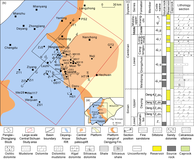
Fig. 1. (a) Locations of the study area, (b) Deyang-Anyue Rift and Central Sichuan paleouplift and (c) composite stratigraphic column of Sinian-Cambrian in the Sichuan Basin. |
The Sinian System develops the Doushantuo Formation and the Dengying Formation from bottom to top. The Doushantuo Formation is mainly composed of shale and silt-fine sandstone, with interbedded micritic dolomite (Fig. 1 c). The Dengying Formation is widely developed in the Sichuan Basin, with a thickness of 50-1400 m, and is divided into four lithological members from bottom to top, which are referred to as Deng 1 Member, Deng 2 Member, Deng 3 Member and Deng 4 Member (Fig. 1 c).
During the sedimentary periods of the Deng 1 Member and Deng 2 Member, the regional tension effect caused the development of multiple normal faults in the Deyang-Anyue region, forming a structural pattern of multiple rows of horst and graben [18-19]. In the horst belts, fault-controlled platform margin mound-shoal complexes are developed, whose lithology is dominated by algal dolomite of grape-lace structure, and in the graben belts, relatively tight intertidal argillaceous dolomite is deposited [11]. During the sedimentary period of the Deng 3 Member, the water body was deepened as a whole, the blue-gray mudstone was developed in the rift, and thinner dark mudstone was developed outside the rift [11]. The regional tension effect peaked during the sedimentary period of the Deng 4 Member [3⇓-5]. Undercompensated dolomitic mudstone and argillaceous dolomite were developed in the rift, with a thickness of 20 m; high-steep rimmed platform margin mound-shoal complexes were developed outside the rift, mainly composed of algal dolomite, algal arenaceous dolomite and stromatolitic dolomite, with a thickness of 200-300 m [10]. Afterwards, the sea level rose gradually, and the rift was filled with thicker Maidiping Formation sediments, mainly composed of dark siliceous shale and siliceous dolomite, with interbedded dolomitic mudstone, etc., while the filling thickness of the Maidiping Formation outside the rift was smaller or zero. During the sedimentary period of the Qiongzhusi Formation, the sea level rose on a large scale, and the very thick Qiongzhusi Formation was deposited in the rift. The lower part was dominated by dark shale, and the upper part was mainly shale with interbedded thin siltstone, forming the important source rock in the Sichuan Basin. The sedimentary thickness around the rift was relatively small, with a thickness of 200-300 m [6,15] (Fig. 1 c).
2. Types and structural features of platform margins of the Dengying Formation
Based on core and thin section observation and seismic data interpretation, it is concluded that there are four types of platform margins in the Dengying Formation of the Deyang-Anyue Rift and its periphery of the Sichuan Basin, including single-stage fault-controlled platform margin, multi-stage fault-controlled platform margin, gentle slope platform margin, and overlapping platform margin. Controlled by different geological conditions during the deposition periods, different sedimentary assemblages were developed with different geological and seismic facies features (Table 1 and Fig. 2 ).
Table 1. Structural features of different types of platform margins in Dengying Formation of the Deyang-Anyue Rift and its periphery |
| Type | Slope gradient | High-energy zone position | Typical lithofacies and assemblage | Logging response features | Seismic facies features |
|---|---|---|---|---|---|
| Single-stage fault- controlled type | ≥45° | Upthrown wall of the fault | Mound-shoal complex, assemblage of thin algal arenaceous dolomite and algal laminated dolomite. | GR is about 12 API; resistivity is characterized by serrated middle-high value. | Mounded or annular shape, low frequency, medium-weak amplitude reflection. |
| Multi-stage fault- controlled type | 10°-45° | High position of the faulted horst | Mound-shoal complex, assemblage of thick algal agglomerate dolomite, algal arenaceous dolomite and algal dolomite. | GR is about 6 API; resistivity is smaller in the middle and larger in the upper and lower. | Mounded shape, low frequency, chaotic weak reflection. |
| Gentle slope type | ≤1° | Neritic zone of Deng 2 Member slope | Granular shoal, assemblage of thick sparry arenaceous dolomite and thin algal laminated dolomite. | GR is about 4 API; resistivity is smaller in the middle and larger in the upper and lower. | Low-gentle mounded shape, medium-low frequency, intermittent medium-weak reflection. |
| Overlapping type | 20°-45° | Rift margins of Deng 2 and Deng 4 members | Algal mound and mound-shoal complex, assemblage of thick algal dolomite with algal stromatolitic and algal lamina structure and thin algal arenaceous dolomite. | GR is about 9 API; resistivity is smaller in the middle and larger in the upper and lower. | Tower shape, medium- low frequency, blank or chaotic weak reflection. |

Fig. 2. Seismic sections of different types of platform margins in Dengying Formation of the Deyang-Anyue Rift and its periphery, Sichuan Basin (see section locations in |
2.1. Structural features of single-stage fault-controlled platform margin
The single-stage fault-controlled platform margin is distributed in the Gaoshiti West-Weiyuan East area, located in the rift of the sedimentary period of the Deng 4 Member, and only the mound-shoal complexes of the platform margin of the Deng 2 Member is developed. Controlled by synsedimentary faults [11], mounded or annular mound-shoal complexes were developed around the upthrown walls of the faults, and relatively thin and fine-grained platform-flat micritic dolomite sedimentary bodies were developed on the downthrown walls of the faults. The combination of the two forms a relatively steep fault-controlled platform margin structure, with a slope gradient generally greater than 45°. This type of platform margin presents as mounded or annular shape on seismic section, with low frequency and weak amplitude reflection, and the thickness of strata on both sides of the faults is greatly different (Fig. 2 a).
2.2. Structural features of multi-stage fault-controlled platform margin
The multi-stage fault-controlled platform margin is developed in the Lezhi-Penglai-Yanting region on the east side of the northern section of the rift. Controlled by the synsedimentary faults, mound-shoal buildup is developed in the relatively high faulted horst belt (some experts call it horst-controlled mound and shoal [11]), and tight intertidal belt is developed in the relatively low- lying faulted graben region, forming a stepped fault-controlled platform margin structure. Broken by fault, several assemblages of buildup platform margin belt mound- shoal complex and tight intertidal belt are developed. This type of platform margin is presented as mounded-shape, low-frequency and chaotic weak reflection on the seismic section, and gradually transits to high-frequency continuous layered strong reflection of the deep-water area (Fig. 2 b). Well Pengtan-1, Well Zhongjiang-2 and other wells reveal that in this type of platform margin mound-shoal complex, platform margin granular shoal facies with huge thickness is mainly developed with the deposits of algal mound facies (Fig. 3 a). The lithology of the granular shoal facies is mainly composed of algal agglomerate dolomite, sparry arenaceous dolomite, grape-like dolomite, sparry algal arenaceous dolomite (Fig. 4 a-4d), with well-developed dissolution vugs and pinholes. Jiaotan-1, Pengshen-2 and other wells penetrated the mound-shoal complexes of Deng 4 Member in Yanting region, with major lithology of algal agglomerate dolomite, algal arenaceous dolomite and sparry arenaceous dolomite (Fig. 4 e-4h). This platform-margin mound-shoal complex is similar to the overlapping platform margin mound-shoal complex in Gao-Mo region, where sedimentary assemblage of algal mound facies and granular shoal facies with huge thickness is also developed (Fig. 3 b). Unlike Gao-Mo region, its algal mound facies is dominated by algal agglomerate dolomite, and the sand debris also shows obvious sparry cementation, indicating that its water body was relatively open and its energy was higher.

Fig. 3. Composite histogram of sedimentary facies in typical wells of different types of platform margins in Dengying Formation of the Deyang-Anyue Rift and its periphery, Sichuan Basin (GR—Gamma ray; Rlld—resistivity of deep laterolog; Rlls—resistivity of shallow laterolog). |

Fig. 4. Sedimentary features of different types of platform margins in Dengying Formation in typical wells of the Deyang-Anyue Rift and its periphery, Sichuan Basin. (a) Well Pengtan-1, 5779.10 m, Deng 2 Member, algal agglomerate dolomite, with well-developed karst caves; (b) Well Zhongjiang-2, 6553.40 m, sparry arenaceous dolomite, with well-developed pinholes; (c) Well Pengtan-1, 5782.65 m, Deng 2 Member, grape-like dolomite, karst vugs are filled with lace-like multi-stage dolomite, cast thin section (−); (d) Well Pengtan-1, 5731.56 m, Deng 2 Member, sparry algal arenaceous dolomite, cast thin section (−); (e) Well Pengshen-2, 7791.95 m, Deng 4 Member, algal agglomerate dolomite, with well-developed vugs; (f) Well Pengshen-1, 7262.35 m, Deng 4 Member, algal arenaceous dolomite, with well-developed bedding vugs; (g) Well Jiaotan-1, 5621.50 mm, Deng 4 Member, sparry arenaceous dolomite, cast thin section (−); (h) Well Pengshen-2, 7789.50 m, Deng 4 Member, algal agglomerate dolomite, cast thin section (−); (i) Well Zi-1, 4029.20 m, Deng 2 Member, grape-like dolomite; (j) Well Zitan-1, 4934.20 m, Deng 2 Member, sparry algal arenaceous dolomite, with well-developed pinholes; (k) Well Zi-2, 4015.26 m, Deng 2 Member, sparry arenaceous dolomite, cast thin section (−); (l) Well Wei-117, Deng 2 Member, 3968.21 m, sparry algal arenaceous dolomite, cast thin section (−); (m) Well Gaoshi-1, 4975.20 m, Deng 4 Member, algal stromatolitic dolomite, with well-developed vugs; (n) Well Gaoshi-1, 4968.40 m, Deng 4 Member, algal laminated dolomite; (o) Well Gaoshi-6, 5352.62 m, Deng 2 Member, micritic and sparry algal arenaceous dolomite, cast thin section (−); (p) Well Gaoshi-1, 4987.21 m, Deng 4 Member, foamy sponge dolomite, cast thin section (−). |
2.3. Structural features of gentle slope platform margin
The gentle slope platform margin is distributed in the Weiyuan-Ziyang region on the west side of the central section of the rift, which is located in the rift of the sedimentary period of the Deng 4 Member, and only the platform margin mound-shoal complex of the sedimentary period of the Deng 2 Member is developed. In the early stage of rifting, there was a paleogeographic pattern of steep in the east and gentle in the west [16-17]. In the neritic zone of the west slope, high-energy shoal deposits were developed to form carbonate gentle slope platform margin, with a smaller slope gradient (less than 1°). On the seismic section, such platform margin is characterized by the assemblage of low-gentle mounded shape, chaotic weak reflection and front-end overlapping reflection [19] (Fig. 2 c). Well Zi1 penetrated this type of platform margin mound-shoal complex, and reveals that the deposits of thick granular shoal and thin algal mound are developed, with major lithology of sparry arenaceous dolomite and sparry algal arenaceous dolomite. The pinhole and grape-lace structures are widely developed (Fig. 4 i-4l), which shows that it has suffered strong penecontemporaneous karstification and developed a large amount of reservoir space.
2.4. Structural features of overlapping platform margin
The overlapping platform margin is developed in the middle-north section of the east side of Deyang-Anyue Rift. The platform margin belt of the sedimentary period of Deng 2 Member coincides with that of Deng 4 Member. The platform margin mound-shoal complexes of the two periods overlap with each other, forming a relatively high-steep aggraded platform margin structure, with slope gradient of 20°-45° and an average of 30°. This type of platform margin is characterized by tower-shaped or large mound-shaped low-frequency blank or chaotic weak reflection on seismic section, which is in sharp contrast with the high-frequency continuous layered strong reflection features of its adjacent deep-water sediments [18] (Fig. 2 d). The drilled wells of Anyue gas field reveal that the sedimentary assemblage of platform margin algal mound and mound-shoal complex with huge thickness are developed in such platform margin (Fig. 3 c). The lithology of algal mound facies is mainly algal stromatolitic dolomite, algal laminated dolomite, algal arenaceous dolomite and foamy sponge dolomite (Fig. 4 m-4p), with well-developed dissolution vugs and pinholes [15]. Under the influence of Tongwan movement, the tops of the mound-shoal complexes at the platform margin of the Deng 2 and Deng 4 members suffered from supergene karstification [13], where a large number of karst breccia and non-selective dissolution vugs are formed.
3. Seismic facies and distribution of platform margins
3.1. Seismic facies features of platform margins
Different sedimentary facies of platform margin, platform and basin have different seismic facies features (such as continuity, amplitude and frequency) on seismic section, so different sedimentary facies belts can be described by using changes in seismic facies features [18]. By integrating geological, drilling, seismic and other data, the through-well seismic section is analyzed, and the confirmed seismic facies features of the sedimentary facies belts of platform margin, platform and basin (Fig. 5 ) are summarized, so as to lay the foundation for finding new favorable seismic facies belt, sedimentary facies belt and exploration zone.

Fig. 5. Seismic facies features of different types of sedimentary facies in the Dengying Formation of the Deyang-Anyue Rift and its periphery, Sichuan Basin (see the profile location in |
The basin facies is in the rift, with clear reflection features of wave group, good continuity of seismic events, medium-strong amplitude, and medium-high frequency. This can be seen on the 2D pre-stack time migration section (referred to as seismic section) through Well Ziyang-1 in the first line of Fig. 5 .
The multi-stage fault-controlled independent platform margin of the Deng 2 Member is located in the rift and its margin, and its seismic reflection is characterized by large time difference (see the flatten section), mostly bracket-like outline (see the variable density section), multi-event chaotic reflection (see the waveform section), medium-weak amplitude, and medium-low frequency. This can be seen on the seismic section through Well Pengtan-1 in the second line of Fig. 5 . The overlapping platform margins of the Deng 2 Member and the Deng 4 Member are located at the rift margin, with large seismic reflection time difference, “mound-shaped” or bracket- like outline (see the variable density section and flatten section), internal reflection of chaotic or earthworm shape (see waveform section), medium-weak amplitude and medium-low frequency. The Deng 2 Member and the Deng 4 Member are separated by the continuous strong reflection seismic event of the Deng 3 Member (see waveform section), as shown on the seismic section through Well Gaoshi-3 in the third line of Fig. 5 . The platform facies is inside the platform, with decreased seismic reflection time difference (see variable density section and flatten section), parallel continuous seismic events, medium-strong amplitude, and medium-high frequency, as shown on the seismic section through Well Hetan-1 in the fourth line of Fig. 5 (see waveform section).
The sedimentary differentiation, the seismic facies of different sedimentary facies (basin, platform margin, platform), and the lateral variation of seismic facies of platform margins with different structural types in the Dengying Formation are obvious on the large seismic section (Fig. 6 ). The overlapping sedimentation phenomenon of the Lower Cambrian in the rift to some regions, such as Well Gaoshi-6 (Fig. 6 a), Well Pengtan-1 (Fig. 6 b) and Well Jiaotan-1 (Fig. 6 c), is obvious. The outline of the Sinian Dengying Formation in the overlapped regions presents mounded or bracket-like shape, and its inside shows chaotic or earthworm reflection, medium-weak amplitude and medium-low frequency, which are the typical features of seismic facies at the platform margin (Fig. 6 a-6c). It is located on the north slope of the Central Sichuan paleouplift (Fig. 1 a). In the tensional tectonic setting before the Cambrian sedimentation, the depositional-structural pattern of horst and graben was formed. The relatively higher palaeogeomorphology was in the deposition environment with relatively higher energy, with platform margin mound-shoal complexes developed (Fig. 6 d, 6e).

Fig. 6. Comparison of seismic sections of different sedimentary facies and different types of platform margins in the Dengying Formation of Deyang-Anyue Rift and its periphery, Sichuan Basin (The section locations are shown in |
3.2. Distribution of platform margins
The thickness of the Deng 3 and Deng 4 members in the Deyang-Anyue Rift is less than 50 m (Fig. 7 a). The residual stratum thickness in Anyue region on the east side of the middle section of the rift changes sharply, indicating the relatively high-steep platform margin structure of the Deng 4 Member. The residual stratum thickness of the north and south sections of the rift changes gradually, indicating a relatively low-gentle platform margin. The thickness maps of the Deng 1 Member-Deng 2 Member (Fig. 7 b) show that the residual thicknesses of the Deng 1 Member-Deng 2 Member change sharply in Anyue-Penglai region, while changing relatively gradually in other regions, indicating that different types of platform margin structures were developed during the sedimentary period of the Deng 2 Member. According to the classification of platform margins (Table 1 and Fig. 2 ) and the summarized seismic facies features of different sedimentary facies (Fig. 5 ), as well as the 2D and 3D seismic data of the large-scale Central Sichuan study area (Fig. 1 a), combined with the actual drilling data and the residual stratum thickness map of the Dengying Formation (Fig. 7 ), the plane distribution of different types of platform margins is accurately identified and depicted (Fig. 8 a), and the sedimentary facies map (Fig. 8 b) is plotted. For the overlapping platform margins (Fig. 8 a), the platform margin belts were vertically superimposed during the sedimentary periods of the Deng 2 Member and Deng 4 Member (Fig. 8 b). They are located at the margins of the middle-north sections of the east side of Deyang-Anyue Rift, and distributed in the Anyue-Shehong-Yanting region. They are distributed in nearly north-south direction in the Anyue-Shehong section, and change to northeast direction in the Shehong-Yanting section. For the single-stage fault-controlled platform margin (Fig. 8 a), only the platform margin belt of the sedimentary period of the Deng 2 Member is developed, which is distributed between Gaoshiti west and Weiyuan east in a crescent shape in the nearly northwest direction (Fig. 8 b). The multi-stage fault-controlled platform margins (Fig. 8 ) are distributed in the Lezhi-Penglai region, located in the rift. Controlled by three NW-trending major faults, a NW-trending third-step platform margin belt is developed. The gentle slope platform margins (Fig. 8 a) are distributed in the following two regions: (1) Ziyang-Weiyuan region, located in the west side of Deyang-Anyue Rift, and the platform margin belt of the sedimentary period of the Deng 2 Member (Fig. 8 b) is distributed in nearly NW direction; (2) Dazu region, located on the east side of Deyang-Anyue Rift, and the platform margin belt of the sedimentary period of the Deng 4 Member (Fig. 8 b) is distributed in nearly SN direction.
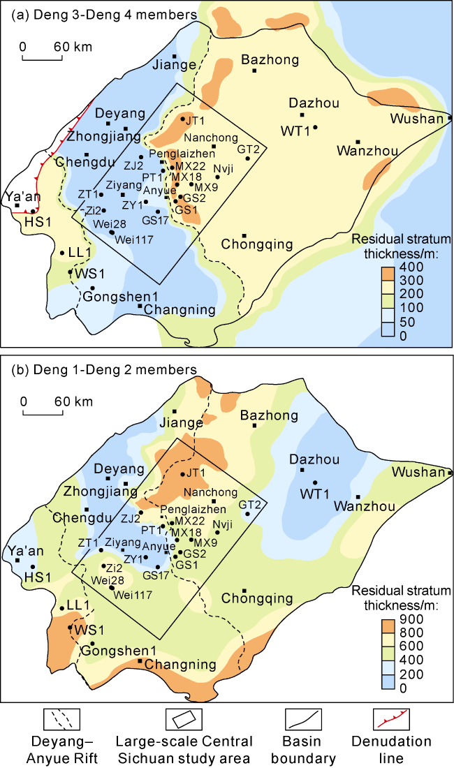
Fig. 7. Residual thickness map of Sinian in the Sichuan Basin. |

Fig. 8. (a) Distribution of different types of platform margins and (b) sedimentary facies of Dengying Formation in the large-scale Central Sichuan study area, Sichuan Basin. |
4. Reservoir physical properties and hydrocarbon enrichment model of mound-shoal complexes in platform margin belt
4.1. Reservoir physical properties of mound-shoal complexes
There are also differences in sedimentary features, reservoir development scale and physical properties of different types of platform margins (Table 2 ). In Gao-Mo region, the mound-shoal facies reservoir lithology of overlapping platform margin is mostly algal stromatolitic dolomite and algal arenaceous dolomite. The reservoir thickness of Deng 4 Member is 25-70 m, and the reservoir space is mainly dissolved vugs in algal stromatolitic dolomite (Fig. 4 m), with an average porosity of 3.2%. The reservoir thickness of Deng 2 Member is 60-100m, and the reservoir space is mainly intergranular pores in algal arenaceous dolomite (Fig. 4 o), with an average porosity of 3.0%. In Yanting region, the mound-shoal facies reservoir lithology of the overlapping platform margin is mostly algal agglomerate dolomite and algal arenaceous dolomite. The reservoir thickness of the Deng 4 Member in Well Jiaotan-1 and Well Pengshen-2 is about 160 m, and the reservoir space is mainly composed of dissolved vugs between penecontemporaneous agglomerates (Fig. 4 g, 4o) in algal agglomerate dolomite, with an average porosity of 3.6%. At present, there is no exploratory wells encountering the single-stage fault-controlled platform margin of Deng 2 Member, and the reservoir thickness of the Deng 2 Member is estimated to be 40-50 m. In Ziyang-Weiyuan region, the mound-shola facies reservoirs at the gentle slope platform margin belt of the Deng 2 Member are mainly developed in arenaceous dolomite. The densely developed dissolution vugs are the main reservoir space (Fig. 4 j). The average reservoir thickness is 26 m, the average porosity is 5.7%, and the plane porosity is about 8.1%. The thickness of the mound-shoal facies reservoir at the multi-stage fault-controlled platform margin of the Deng 2 Member in Penglai region can be up to 264 m, and the reservoir space is mainly composed of dissolved vugs in algal agglomerate dolomite and pinholes in arenaceous dolomite (Fig. 4 a, 4b), with an average porosity of 3.5%.
Table 2. Reservoir physical properties of platform margin mound-shoal facies in Dengying Formation of the Deyang- Anyue Rift and its periphery, Sichuan Basin |
| Types of platform margins | Distribution region | Reservoir of Deng 4 Member | Reservoir of Deng 2 Member | ||||
|---|---|---|---|---|---|---|---|
| Thickness/m | Porosity/% | Plane porosity/% | Thickness/m | Porosity/% | Plane porosity/% | ||
| Single-stage fault-controlled type | Weiyuan East- Gaoshiti West | 40-50 | 1.2 | 2.0 | |||
| Multi-stage fault-controlled type | Penglai-Yanting | 100-170 | 3.6 | 3.6 | 100-265 | 3.5 | 5.3 |
| Gentle slope type | Ziyang-Weiyuan | 20-65 | 5.7 | 8.1 | |||
| Overlapping type | Gao-Mo | 25-70 | 3.2 | 6.0 | 60-100 | 3.0 | 2.9-3.2 |
In general, the multi-stage fault-controlled platform margin mound-shoal complex has large scale, large reservoir thickness and good physical properties, following by the overlapping platform margin mound-shoal complex. The gentle slope platform margin mound-shoal complex has smaller thickness of single reservoir, higher reservoir physical properties, wide lateral distribution, and better reservoir performance of the vertically stacked multi-layer reservoirs; the single-stage fault-controlled platform margin belt is jointly controlled by faults and palaeogeomorphology, and it is predicted that mound- shoal reservoirs can also be developed here.
4.2. Hydrocarbon enrichment model in the platform margin belt
Sedimentary platform margin belts controlled by synsedimentary faults are developed in the Deng 4 and Deng 2 members, and large mound-shoal reservoirs are developed on the platform margin belts [20]. The thickness of the platform margin belt of the Deng 4 Member is 200-400 m (Fig. 7 a), and that of the Deng 2 Member is 400-900 m (Fig. 7 b). The width of the platform margin belts is 40-120 km.
The mound-shoal reservoir on the platform margin belt of the Dengying Formation is covered by the 150-700 m-thick Lower Cambrian high-quality source rock controlled by Deyang-Anyue Rift (Fig. 9 a). The mound-shoal reservoir on the platform margin belt of the Dengying Formation in the rift and its periphery has superior near-source and efficient gas supply conditions. During the critical period of hydrocarbon generation (before the deposition of the Permian system), the platform margin belts were located at the relatively high position of the ancient structure (Fig. 9 b). During the critical period of hydrocarbon accumulation (before the deposition of the Jurassic system), the platform margin belts were also located at the relatively high position of the ancient structure (Fig. 9 c). Nowadays, the platform margin belts are still at the high position of hydrocarbon migration and accumulation (Fig. 9 d). The research shows that the platform margin belts of Dengying Formation have favorable conditions for hydrocarbon accumulation, forming a good hydrocarbon accumulation assemblage and hydrocarbon enrichment model with side generation and side storage, lower generation and upper storage (Fig. 10 ).
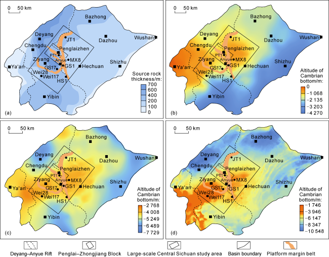
Fig. 9. Composite evaluation maps of the platform margin belts of Dengying Formation in large-scale Sichuan study area, Sichuan Basin. (a) Overlapping map of thickness of Lower Cambrian source rocks and platform margin belts in Sichuan Basin; (b) Overlapping map of paleo-structures on Sinian top before the deposition of Permian and platform margin belts in Sichuan Basin; (c) Overlapping map of paleo-structures on Sinian top before the deposition of Jurassic and platform margin belts in Sichuan Basin; (d) Overlapping map of current structures on Sinian top and platform margin belts in Sichuan Basin. |
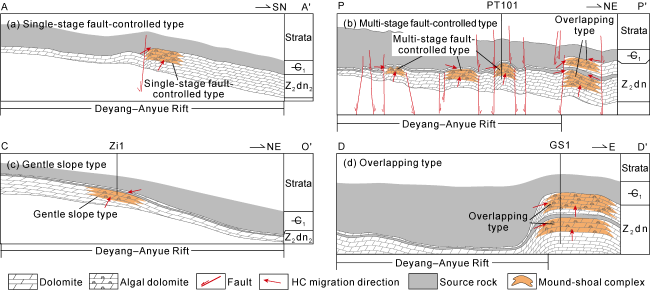
Fig. 10. Sections of hydrocarbon accumulation models in various types of platform margins of Dengying Formation in the Deyang-Anyue Rift and its periphery, Sichuan Basin (the locations are shown in |
The single-stage fault-controlled platform margins in the Weiyuan east-Gaoshiti west are located at the saddle of the paleouplift (Fig. 9 b, 9c). Being shielded by faults and massive mudstone in the rift, fault-controlled- lithological traps with sufficient gas source are formed in the platform margin mound-shoal complexes (Fig. 10 a).
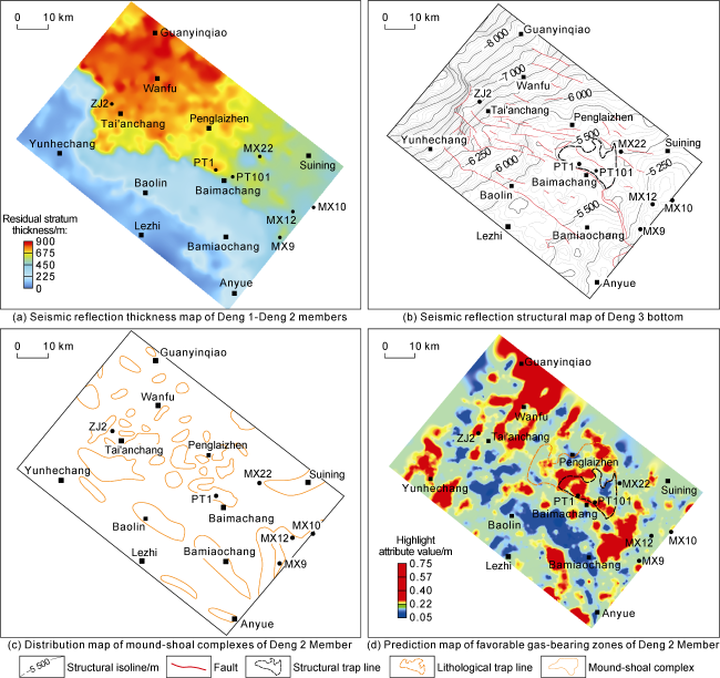
In Penglai-Zhongjiang block (Figs. 1a and 9), the multi-stage fault-controlled platform margin displays thickness clearly in the seismic reflections of the Deng 1 -Deng 2 members, and the color variation of the stratum thickness in the three zones (Anyue North, Baolin and Baimachang) is abrupt (Fig. 11 a), indicating the abrupt change of the stratum thickness, which means the development of the platform margin belt. The mound-shoal complexes on multi-stage fault-controlled platform margin are surrounded by the Cambrian source rocks (Fig. 9 a), so they have better source-reservoir configuration. During the early period, they were paleouplifts (Fig. 9 b, 9c), which is conducive to oil and gas migration and accumulation. Currently, they are located on the north slope of the paleouplift (Fig. 9 d), which is a large monoclinal structural setting. For lithological trap, being controlled by faults, the mudstone with huge thickness in the tight belt and updip direction effectively seals oil and gas, mainly forming fault-controlled-lithological trap. Small structures are developed locally, forming multiple types of traps, such as structural-lithological trap, fault-controlled-lithological-structural trap and lithological trap (Fig. 10 b).
Fig. 11. Composite evaluation maps of Penglai-Zhongjiang Block in the Sichuan Basin. |
In Ziyang-Weiyuan region, the gentle slope platform margin is covered by the Cambrian source rocks with huge thickness (Fig. 9 a), and the hydrocarbon supply is sufficient. Before the deposition of Permian and Jurassic systems, it was located in the high position of the paleouplift, which is the dominant area of hydrocarbon migration and accumulation (Fig. 9 b, 9c), and now it is located in the north slope of Weiyuan structure (Fig. 9 d). Hydrocarbons accumulate to the thin interbedded mound-shoal complexes on the gentle slope, and are shielded by the intertidal micritic dolomite tight belt in the updip direction, forming lenticular lithological trap (Fig. 10 c), such as the high-yield gas reservoir drilled by Well Zi-1. Therefore, the shielding of tight belt in the updip direction of gentle slope zone is the key to hydrocarbon accumulation in gentle slope platform margin mound-shoal complexes in the slope area.
In Gao-Mo region, the overlapping platform margin mound-shoal complexes are in lateral contact with the high-quality source rock of the rift. This area has always been at the high position of hydrocarbon migration and accumulation (Fig. 9 b-9d), so hydrocarbons can directly charge into the reservoir space to form structural-stratigraphic or structural-lithological traps (Fig. 10 d).
5. Favorable exploration zones and exploration directions
The coring result of Well Pengtan-1 confirms the development of the platform margin mound-shoal facies [8], which not only confirms the existence of the platform margin during the sedimentary period of the Deng 2 Member in the Penglai-Zhongjiang block in the rift, shows good exploration prospect of the rift and the north slope, but also expands the exploration domain. The breakthrough of Well Jiaotan-1 further confirms the development of large lithological gas reservoirs in the north slope [9,11], and realizes the successful transformation of the exploration idea from structural gas reservoirs to lithological gas reservoirs in the Sinian-Cambrian of the Sichuan Basin.
Based on the research results of source rock conditions, paleostructure analysis (Fig. 9 ), platform margin distribution (Figs. 8a and 11a), structural pattern (Fig. 11 b), distribution of mound-shoal complexes (Figs. 8b and 11c), prediction of favorable gas-bearing area (Fig. 11 d), hydrocarbon enrichment model (Fig. 10 d) and risk analysis, the Penglai-Zhongjiang block is evaluated as the most favorable exploration zone in the slope area of the paleouplift. Three mutually independent stages of platform margin belts of the Deng 2 Member are developed in this block. The first-stage platform margin is located near Anyue-Lezhi, the second-stage platform margin is located near Bamiaochang-Baolin-Yunhechang, and the third-stage platform margin is located in Baimachang-Penglaizhen-Tai'anchang region (Fig. 11 a). An independent structural trap of this block is developed at location of Penglaizhen, with the highest structure point at −5360 m in elevation. The trap is formed at −5480 m of elevation, with an area of 151 km2 (see structural trap line in Fig. 11 b) and a closure height of 120 m. According to the reservoir thickness of the Deng 2 Member in the exploration wells in Gao-Mo region, many kinds of seismic attributes are extracted along the bottom of the Deng 3 Member with a time window of 30 ms, and the coincidence with the actual drilling results is analyzed. It is found that the red zones with high values of highlight seismic attribute (Fig. 11 d) better reflect the reservoir development and favorable gas-bearing zones in this region. The description of mound-shoal complexes by seismic facies (Fig. 11 c) and the prediction of favorable gas-bearing zones (Fig. 11 d) indicate that a mound-shoal lithological trap with an area of about 350 km2 is developed near Penglaizhen (see lithological trap line in Fig. 11 d), and the highest part of structural-lithological trap is the most favorable exploration target in this block. By composite characterization through seismic facies and favorable gas-bearing zones, the total area of the mound-shoal complexes at the platform margin is about 1200 km2 (Figs. 8 , 11 c, 11d). The reserves abundance is taken as (2-5)×108 m3/km2, and thus the amount of resources is estimated to be (1500-3500)×108 m3. In northern Moxi-Yanting region, overlapping platform margin mound-shoal belts are developed, with a total area of about 860 km2 and estimated amount of resources of (1700-4300)× 108 m3. In western Gaoshiti-Weiyuan-Ziyang region, the total area of the mound-shoal complexes at the platform margin of the Deng 2 Member is about 1600 km2, and the estimated amount of resources is (3000-8000)×108 m3. The above three platform margin mound-shoal belts are close to the rift, with excellent hydrocarbon source conditions and high-quality mound-shoal complexes-karst reservoir. Shielded by faults, intertidal tight zones and sealed by Cambrian mudstone in multiple directions, several types of traps (such as lithological, structural- lithological and fault-controlled-lithological traps) are developed. They are located at a relatively high position of the paleostructure, so they are in a favorable direction for hydrocarbon migration and accumulation, with good hydrocarbon geological conditions and favorable hydrocarbon accumulation conditions. In conclusion, they are favorable zones and exploration directions for the next exploration and development of the Dengying Formation.
6. Conclusions
Four types of platform margins are developed in the Dengying Formation of the Deyang-Anyue Rift and its periphery, i.e., single-stage fault-controlled platform margin, multi-stage fault-controlled platform margin, gentle slope platform margin, and overlapping platform margin.
The single-stage fault-controlled platform margin of the Deng 2 Member is developed in western Gaoshiti-Weiyuan east region, which is effectively shielded by faults to form gas reservoir in fault-controlled-lithological trap. In Lezhi-Penglai area, the mutually independent multi-stage fault-controlled platform margin of the Deng 2 Member is developed, where arenaceous dolomite and grape-like dolomite reservoirs of arenaceous shoal facies are mainly deposited. Shielded by faults, intertidal tight zones and mudstones, gas reservoirs are formed in fault-controlled- lithological trap, structural-lithological trap and fault- controlled-lithological-structural trap. In Weiyuan-Ziyang area, the gentle slope platform margin of the Deng 2 Member is developed, where arenaceous dolomite of arenaceous shoal facies is mainly deposited to form lenticular gas reservoir in lithological trap. In Gaoshiti- Moxi-Yanting region, the overlapping steep-slope platform margins of Deng 2 and Deng 4 members are developed, where algal dolomite and algal agglomerate dolomite reservoirs of algal mound facies are mainly deposited, which are effectively sealed by surrounding mudstones to form gas reservoirs in structural-stratigraphic, structural-lithological and lithological traps.
The above various types of platform margins are close to the rift, with excellent hydrocarbon source conditions and high-quality mound-shoal-karst reservoir. They are shielded by faults, intertidal tight zones and Cambrian mudstones in multiple directions, and are located in the favorable directions for hydrocarbon migration and accumulation, with good hydrocarbon accumulation conditions, so that a variety of large-scale gas reservoirs are formed in lithological, structural-lithological and fault- controlled-lithological traps, with estimated resources of more than one trillion cubic meters, which is a favorable direction for extending the exploration of the Dengying Formation in the Sichuan Basin.