

Introduction
The oil and gas exploration and geological research in the Linhe Depression of the Hetao Basin began in the late 1970s and went through three major exploration stages [1]: (1) Oil survey and exploration from 1977 to 1987. Seven wells were drilled, and two sets of source rocks and oil and gas shows of the Lower Cretaceous and Oligocene were found. Only a small amount of crude oil was produced from the Cretaceous in Well Linshen 3. On the whole, the target layer is buried deeply and the geological engineering is complex. The thickness of single-layer source rock is thin (0.5-1.8 m) below 5000 m in the central and eastern regions. The maturity of the Paleogene source rock is low, the hydrocarbon expulsion is late (at the end of the Pliocene), and the hydrocarbon generation capacity is limited [2-3]. (2) Exploration of middle-shallow oil and gas from 2004 to 2016. Based on the exploration experience of shallow biogenic gas in the Qaidam Basin, biogenic gas wells were deployed in Huhe Depression and Linhe Depression of the Hetao Basin from 2005 to 2008, but the gas logging was abnormal, and gas test production was low. It is considered that the lack of effective traps is the primary cause of difficulty in forming large-scale gas reservoirs [3]. From 2015 to 2016, two wells were drilled in the Shabu structural belt, and a small amount of oil and gas shows and thin-layered high-quality source rocks were found in the Cretaceous Guyang Formation. With sparse two-dimensional seismic survey, it is difficult to identify traps and make exploration breakthrough. (3) Rapid breakthrough of oil and gas exploration and the discovery of large-scale reserves since 2017 to present. At the beginning of 2018, several wells such as JHZK2 were drilled below 600 m in Jilantai buried hill and obtained high-yield industrial oil flow after fracturing. Through the comparison of buried hill oil source and the analysis of oil and gas migration paths, fault nose structural traps were finely identified in the periclinal and near-sag parts of the buried hill. Wells Jihua 2X and Jihua 4X were drilled, and oil zones over 200 m thick and high-yield industrial oil flows were found in the Paleogene and Cretaceous clastic rocks, which confirmed that the source rocks of the Cretaceous Guyang Formation had great resource potential and achieved a historic breakthrough in oil exploration in the Hetao Basin. The Jilantai oilfield was discovered. From 2019 to 2020, through the three-dimensional seismic survey for fine description of structural traps, a risk exploration well Linhua 1X was deployed at the structural high of the early Well Long 1. High-yield industrial oil flow was obtained from the Paleogene Linhe Formation, and a major breakthrough in oil exploration was made in the northern part of the Linhe Depression, and Bayan Oilfield was discovered.
In recent years, despite the efficient discovery of oil and gas exploration in the Hetao Basin, the spatial and temporal configuration of oil and gas accumulation elements, enrichment law and favorable directions for further exploration in different zones are still unclear, which seriously restricts the continuous exploration and discovery and reserve increase in the future. Therefore, it is necessary to summarize the common characteristics and laws of oil and gas accumulation in the Hetao Basin in combination with exploration practice. At the same time, it is necessary to analyze and predict the accumulation differences in new zones to expand exploration discoveries and avoid unknown risks, and provide exploration enlightenment for areas with similar geological conditions. This paper analyzes the tectonic sedimentary evolution characteristics, source rock characteristics, reservoir characteristics, trap characteristics, oil and gas accumulation mode and enrichment laws in the Hetao Basin to get the deeper geological understanding of the Hetao Basin, and determines the spatial and temporal configuration of oil and gas accumulation elements and oil and gas enrichment laws in different zones to provide guidance and reference for optimizing the next strategic exploration direction.
1. Geologic setting
The Linhe Depression is adjacent to the Seerteng Mountain in the north, to the Ordos Basin, Zhuozi Mountain and Helan Mountain in the southeast, and to the Langshan Mountain in the west. It is an arc-shaped and NE-EW striking depression (Fig. 1 ) with an area of about 2.24×10⁴ km2, and the most important oil-generating depression and oil-bearing area in the Hetao Basin. On the whole, the depression has the structural characteristics of north-south division of zones and east-west division of structural belts. Based on the current structural characteristics, it is divided into two sags and one low bulge in the north-south direction. The northern Bayannur Sag has a deep burial depth (3000-14 000 m), while the southern Jilantai Sag has a shallow burial depth (less than 3000 m). The Dengkou low bulge is developed in the middle, which is formed by the late uplift and has a shallow burial depth. Combined with the latest two-dimensional and three-dimensional seismic data, the basin structure and fault distribution characteristics are redefined. It is clear that Bayannur Sag is divided into Naoxi subsag belt, Xinglong fault structural belt, Nalinhu faulted buried hill belt, Yellow River fault trough belt and Wuyuan slope belt from west to east. The Jilantai Sag is divided into Jilantai structural belt, Shabu structural belt, Jixi subsag belt and Jidong slope belt (Fig. 1b ). The basement of the basin is the metamorphic series of Archean Wulashan Group. From bottom to top, the Lower Cretaceous Lisangou Formation and Guyang Formation, the Paleogene Eocene Wulate Formation, the Oligocene Linhe Formation, the Neogene Miocene Wuyuan Formation, the Pliocene Wulantuke Formation and the Quaternary Hetao Group are developed. Among them, the Lower Cretaceous Guyang Formation and the Oligocene Linhe Formation develop high-quality source rocks of saline lacustrine facies, which are also the most important oil-bearing formations. The Lisangou Formation, Wulate Formation and Wuyuan Formation are dominated by red mudstone, which is a regional cap rock, forming a reservoir-forming combination of self-source and self-reservoir, side-source and lateral-reservoir, and new-source and old-reservoir (Fig. 1c ).

Fig. 1. (a) Location of the study area, (b) tectonic units and (c) composite stratigraphic column of the Linhe Depression in Hetao Basin. |
2. Petroleum geology
2.1. Structure-sedimentary evolution features
Since the 1980s, there have been different views on the nature of the basin and stress mechanism during the initial basin-forming period. In the early stage, Zhao [4] believed that the Hetao Basin was an arch-tension and faulted depression basin in Cretaceous, a series of positive faults developed in the basin and controlled the basin deposition. Fu, Zhao and Guo et al. [3,5⇓ -7] concluded that the Hetao Basin was an extruded depression basin in Cretaceous and was a faulted basin in Paleogene with the depositional centers located in the northwest of the basin, where dark mudstone of semi-deep lacustrine facies is dominant. This understanding had been dominant in the early exploration period. Recent studies suggest that during the Early Cretaceous (Lisangou Formation depositional period), the basin might be an extrusion depression where the Bayannur Sag in the north was mainly affected by the extrusion from the NW-striking Tianshan Mountain and the nearly WE-striking Xingmeng fold belt, while the Jilantai Sag in the south was mainly affected by the nearly WE-striking bi-directional extrusion from the Helan Mountain in the east and the Bayanwula Mountain in the west [8-9], forming the embryonic of the early NNE Lang Mountain and branch faults, Yellow River fault, Bayanwula fault, Nalinhu fault, Jican 1 east fault, near east-west Hangwu fault, and other present first-order and second-order faults (Fig. 1b ). During that period, the distribution of the formations was limited, mainly concentrated in the present Lang Mountain and Jilantai Sag in the central and western parts, and the main body of the Hetao Basin was still an uplifted and denuded area (Fig. 2 ). However, in the middle and late Early Cretaceous (Guyang Formation depositional period), the main part of the basin entered the sedimentation and basin-forming period, and the basin was dominated by the extensional environment. Under the control of the western Lang mountain fault and the eastern Yellow River fault, an asymmetric graben was developed with eastern and western faults. The overall thickness of the formation does not change much (Fig. 3 ). In addition, recent discoveries of several basaltic craters in the northern and central outcrop areas of the Lang Mountain confirmed that the eruption was consistent with the deposition of the Guyang Formation (about 120 Ma) [10]. The Erlian Basin, which is adjacent to the Hetao Basin, was in a strong extensional fault depression period during this deposition period, and high-quality source rocks of the Tengger Formation were developed [11]. During the Guyang Formation sedimentary period, co-depositional normal faults were developed. Comprehensive analysis suggests that, the Hetao Basin is located in a strong extensional stress environment, and characterized as a fault-depression basin in a weak extensional stress environment. Under the influence of early extrusion extending northward from the Zhuozi Mountain and the Dengkou low bulge, large early low uplifts were developed, forming a structural prototype of east-west division and an occluded lacustrine sedimentary center in the western Naoxi sub-sag and Jixi sub-sag belts, where high-quality source rocks of saline lacustrine facies were developed. According to early drilling data, sedimentary rock types in different regions are obviously different. The mineral composition in Shabu structural belt in the south is dominated by quartz with content over 75%, and it gradually decreases to the north, while the content of feldspar and rock debris gradually increases. The quartz content decreases to less than 40% in Xinglong structural belt (Fig. 4a ). Considering the characteristics of large intermountain tectonic transition belts with developed large braided river (fan) delta sediments, and the characteristics of seismic facies, it’s suggested that, controlled by the Helan Mountain and the Zhuozi Mountain, a distant-source depositional system may be developed in the southern and central Nalinhu faulted buried-hill belt and Shabu structural belt. With insufficient sources (mainly feldspathic and lithic sandstone) in the northern Xinglong structural belt, a near-source depositional system may be developed. The seismic facies at the basin margin in the Jilantai structural belt shows apparently chaotic reflections, but gradually improves towards the internal of the basin where stratification is clear. This is the characteristic of near-source deposition. The Hetao Basin was gradually uplifted in the late Early Cretaceous, making the Upper Cretaceous and the Paleocene missing in the Linhe Depression.

Fig. 2. N-S section of Linhe Depression across the central Hetao Basin (section location shown in |

Fig. 3. Northern across-basin section of Linhe Depression (section location shown in |

Fig. 4. Triangle diagram of rock types in Linhe Depression. I-Quartz sandstone; II-Feldspathic quartz sandstone; III-Lithic quartz sandstone; IV-Feldspathic sandstone; V-Lithic feldspathic sandstone; VI-Feldspathic lithic sandstone; VII-Lithic sandstone. |
Until the Eocene, the Hetao Basin entered the extensional subsidence period again and was mainly in parallel unconformable contact with the Cretaceous. The dark shale deposits were found locally in the Nalinhu fault horst belt, dominated with brown-red mudstone deposits, with a formation thickness of 200-300 m, showing the characteristics of thick in the middle and thin in the north and south, forming a regional good cover. In the Oligocene, influenced by the enhancement of north-west subduction and retreat of the Pacific plate and the tectonic distribution of northern and southern basin mountains, the depositional center of the Hetao Basin gradually moved northward, and the formation thickness was 1000-1300 m, with the overall characteristics of thick in north and west, and thin in south and east. During this period, the faults were dominated by boundary of the basin-controlled ones. Except for the Xinglong fault and the Nalinghu fault, other faults in the basin were less developed, showing the sedimentary characteristics of weakly extensional fault-depression basin with shallow water and slow slopes. Drilling data revealed the mineral composition and high structural maturity of the sedimentary sand bodies which is dominated by rigid particles such as quartz feldspar. In the Xinglong structural belt, the quartz content is 65%, the feldspar content is about 20%, and the lithic content is about 15%. In the Nalinhu structural belt in the south, the lithic content is slightly higher (Fig. 4b ), indicating that the sediments may be from far sources during that period. In addition, considering the present geomorphology and successive development characteristics of the basin, it is believed that large sources may exist in the transition zones between western Lang Mountain and southern Bayanwula Mountain, between Lang Mountain and northern Serten Mountains, between eastern Zhouzi Mountain and Yimeng Uplift, and between Zhouzi Mountain and Helan Mountain, therefore it is possible to develop a large depositional system dominated by braided river delta, forming sandstone and mudstone interbeds in the basin (Fig. 5b ).

Fig. 5. Sedimentary facies of the Cretaceous Guyang Formation and the Paleozoic Linhe Formation in Linhe Depression. |
In the Neogene, the basin extension gradually increased and comfortably contacted with the underlying Paleogene. The Miocene is 1000-1500 m thick, and characterized by thick in the west and thin in the east. The basin in the Pliocene entered a period of strong extension fault depression where fault activities increased significantly, and the thickness of the formation ranged from 500 m to 5000 m, with drastic changes. In addition to the basin-controlling first-order faults, second-order and third-order faults were strongly active (Fig. 3 ), forming the present-day structural pattern of "east-west belts and north-south zones" and four major positive structural belts such as Jilantai, Shabu, Nalinhu and Xinglong, which provide a good structural background for oil and gas accumulation. In addition, without sufficient source, and the Miocene is dominated by the deposition of ultra-thick red mudstone. The mudstone-to-formation ratio in the northern part of the Linhe Depression is as high as 90%, forming a good regional cover. In the southern and central areas near sources, the mudstone-to-formation ratio is 30% to 40%, and the deposition is featured by under-compensation to compensation.
In the Quaternary period, the basin entered a period of thermal subsidence and strike-slip extensional transformation. The sedimentary thickness is 0-2000 m with large variations. Deposition mainly took place in the Bayannur Sag in northern Linhe Depression. But the sedimentary thickness of the Jilantai sag in the south is generally thin, less than 200 m (Fig. 2 ), which is closely related to the overall inversion and uplift of the Jilantai Sag in the south. At the same time, the slip-strike action was significantly enhanced, and a series of oblique and broom-shaped small faults were developed on the early faults. On the profile, they are shown by normal negative flower structures with strike-slip characteristics of compression-torsion. The characteristics of small fault throw but deep-cut multiple sets of sedimentary strata make the intra-basin fractures more complex and easy to form fault noses and fault traps (Fig. 3 ).
2.2. Characteristics of source rocks
There are mainly three sets of source rocks developed in the Linhe Depression, which are the Lower Cretaceous Gu 2 Member (K1g2), Gu 1 Member (K1g1) and Oligocene Linhe Formation (E3l). In the early basin, the Gu 2 Member source rock was mainly distributed in the northern part of the Linhe Depression, with high organic matter abundance and Type II2 and Type III kerogen, and deposited in freshwater and weak reduction environment [9]. The source rocks of the Gu 1 Member and Linhe Formation were widely distributed, with higher organic matter abundance and types I and II1 kerogen. Geochemical indicators show high boron content, low pristane-to-phytane ratio, and high gammacerane (value of gammacerane/C30 hopane greater than 1) (Fig. 6a , 6b). The microscopic fraction of kerogen contains more than 70% of sapropelinite and less than 10% of vitrinite, and microscopic fluorescence irradiation revealed rich algae, mostly unicellular alga (Fig. 7 ). In addition, pyrite was found, and the highest content of reduced sulfur in organic carbon reached 6%, reflecting a fully closed and strongly reduced water environment. It’s a salt/saline lake environment with strongly reducing conditions, and very similar to the salt/saline lakes where source rocks were developed in the Qaidam Basin, Jianghan Basin, and Bohai Bay Basin [12⇓⇓-15]. The K1g1 source rock was deposited in shallow lake water (0.5-2.0 m) with a little water supply and high salinity. The sterane/hopane ratio was 1%-10%, the organic matter was from low aquatic prokaryotes (bacteria), and the biological population was simple halophilic bacteria, with little inter-population phagocytosis consumption, and extremely high biological productivity. Gold tube thermal simulation shows that the source rock may start generate massive hydrocarbon when Ro is 0.4%, and reaches peak hydrocarbon generation when Ro is 0.8%, which is much earlier than the source rocks of other basins, revealing a strong hydrocarbon generation ability of the K1g1 source rock. Compared with K1g1, pregnane is less developed and carotene is more developed in the source rock of the Linhe Formation, especially that the content of γ-carotane is higher than that of β-carotane (Fig. 6b ). The latest study indicates that green sulphur bacteria dominate in the Oligocene paleolake and contribute more to carotenoids. The sterane/hopane ratio of 10%-20% indicates that the organic matter was mainly lower aquatic eukaryotes (plankton), and a small amount of terrestrial debris with high biological productivity. Thermal simulation indicates that the peak hydrocarbon generation rate is 730-790 kg/t [3], revealing a strong hydrocarbon generation ability of the Linhe source rock. According to the comparison of oil sources and the analysis of crude oil maturity, the crude oil of the Linhe Formation in the Xinglong fault belt and the Nalinhu fault buried-hill belt came from the source rock of the Linhe Formation. And based on the maturity index (isomerization index) of C29, it is found that the crude oil of the Linhe Formation is immature and low mature. For example, the C29-20S/(20S+20R) found in Well Song5 is only 16.47%, indicating the crude oil is immature (Fig. 6c ). However, the physical properties of the crude oil is mature, with the density of 0.879 g/cm3, viscosity of 38 mPa∙s, wax content of 14%, sulfur content of 0.71%, freezing point of 33 °C, and asphaltene gum content of 29%. In addition, the C29-20S/(20S+20R) of the reservoirs in wells Linhua1X and Xinghua1 is 20%-30%, indicating the crude oil is in the low maturity stage (C29-20S/(20S+20R is 20%-40%), but the physical properties of the crude oil show mature characteristics. The maturity analysis of source rock at 3000-7000 m concludes that the hydrocarbon generation window of the Linhe Formation source rock is 4000- 5000 m, which is significantly deeper than those in other basins in China [16-17]. Therefore, it is concluded that the source rock of the Linhe Formation has characteristics of high sulfur and rich algae, early maturity and discharge, and a wide hydrocarbon generation window. The latest hydrocarbon resource estimate is 2-3 times higher than the early, which greatly expands the exploration potential of the Hetao Basin.
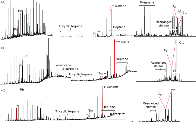
Fig. 6. Mass spectrum of source rocks in Linhe Depression. (a) Dark gray mudstone, Guyang Formation, 3012.54 m, Well Jihua18X; (b) Gray mudstone, Linhe Formation, 4531.00-4540.00 m, Well Xinghua1; (c) Crude oil, Linhe Formation, 3135.20-3137.20 m, Well Song5. |
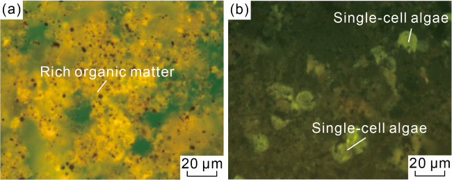
Fig. 7. Fluorescent thin sections of kerogen of source rocks in salt/saline lake facies of Linhe Depression. (a) Rich organic matter, Linhe Formation, 4478 m, Well Xinghua2; (b) Single-cell algae, Guyang Formation, 1925 m, Well JHZK9. |
2.3. Reservoirs
2.3.1. Reservoir space
According to the cast thin sections of the deep reservoir in the latest drilling data, the reservoir space type is basically the same in the Linhe Formation from south to north. It is mainly composed of primary intergranular pores, and a small number of secondary dissolution pores. And local muddy and micritic carbonate minerals causes micropores in the reservoir. The reservoir space of the Guyang Formation is different from south to north. Primary intergranular pores are dominant in the southern and central parts, while secondary dissolution pores are dominant in the northern part. The thin sections of the sedimentary rock in the western part of the basin indicate that the reservoir space of the Linhe and Guyang formations is mainly composed of intergranular pores, secondary dissolution pores and pores caused by structural action.
2.3.2. Reservoir physical properties
Statistical analysis of measured porosity and permeability shows that the Paleogene Linhe Formation buried at 4200-5600 m has good physical properties. The maximum porosity is 27.3% and the median effective porosity is 19.3%. The maximum permeability is 1320×10−3 μm2 and the median effective permeability is 166×10−3 μm2.
The reservoir is characterized by medium porosity and medium permeability. The Cretaceous Guyang Formation in the northern part of the depression buried at 5200-5800 m has poor physical properties. The maximum porosity is 11.9% and the maximum permeability is 2.92×10⁻³ μm2, indicating the reservoir is of low porosity and low permeability.
Vertically, the reduction rate of the effective reservoir porosity of the Linhe Formation is low. According to the relationship between porosity and depth from drilling data, the vertical porosity reduction rate is 2%-3% per 1000 m. Compared with other fault basins in China, the porosity in the Paleogene Linhe Depression varies slowly with depth, and the maximum porosity at different depths has a large downward extension. Based on the analysis of mercury injection data and NMR experiment on the Xinghua structure, it is found that the lower limit of the effective reservoir porosity of the Paleogene clastic rock is 8.5%. Following the trend of porosity variation with depth from drilling data, it is inferred that the lower limit of effective porosity of the Linhe Formation is at 8000 m (Fig. 8a ). The reservoir of the Cretaceous Guyang Formation is deeper, the variation of porosity with depth is faster than that of the Linhe Formation, and the physical properties are relatively poor. It is inferred that the effective reservoir is buried at 6500 m (Fig. 8b ), indicating the Cretaceous Guyang Formation has a large exploration potential.

Fig. 8. Relationship between porosity and burial depth. |
Laterally, the Linhe Formation has the best reservoir properties in Shabu and Xinglong structural belts, followed by the Nalinhu structural belt in the middle of the Linhe Depression. The reason for this is that the Shabu structural belt is shallow, while the Xinglong structural belt, despite its deep burial, has a high content of rigid particles such as quartz, a low content of cement, weak cementation, and a low geothermal gradient (2.0-2.5) °C/100 m. And after a long-term shallow burial and late rapid deep burial, it’s weakly compacted, so the reservoir physical properties are better. The physical properties of the Guyang Formation vary obviously with depth. The deepest Xinglong structural belt has the worst physical properties, while the shallowest Shabu structural belt has the best physical properties, forming a physical property characteristic of gradually better from north to south.
The core porosity at 6037 m depth in the Linhe Formation of Well Hetan1 is 18.2%, confirming that the ultra-deep clastic rock in the Hetao Basin is high-quality reservoir with medium porosity. Firstly the Linhe Formation is distant-source braided river delta deposits with high-maturity composition and structure, quartz content of 76% and strong compaction, which provide an important material basis for high-quality reservoir development. Secondly, the Linhe Depression has a low geothermal gradient, and experienced a long-term shallow burial and then a rapid deep burial (Fig. 9 ), so the compaction is weak, which is conducive to the preservation of primary pores. Thirdly, the cement content of favorable sedimentary facies is low, and has been identified by a large number of casting thin sections. The favorable sedimentary microfacies thicker than 1 m per layer has the cement content generally less than 5%, which is an effective reservoir. By establishing a linear relationship between time-temperature index with porosity and burial depth, respectively, it is predicted that the maximum porosity of the Linhe Formation clastic rock is 11% at 8000 m, which is slightly higher than the predicted value by the aforementioned trend method. The porosity predicted by any method indicates a huge exploration potential of the Linhe Formation.
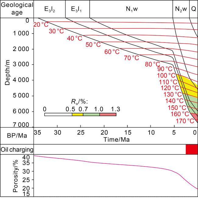
Fig. 9. Geological elements, evolution and reservoir formation of Linhe Formation (E3l2—Oligocene Lin 2 Member, E3l1—Oligocene Lin 1 Member, N1w—Miocene Wuyuan Formation, N2w—Pliocene Wulantuke Formation, Q—Quaternary). |
2.4. Trap features
The strong extensional fault depression activity and strike-slip transformation since the Neogene have provided important conditions for the formation of large fault noses and fault block traps (Fig. 10 ). In general, the structural traps in Linhe Depression can be divided into two types, namely, forward fault nose and reverse fault nose/block traps.
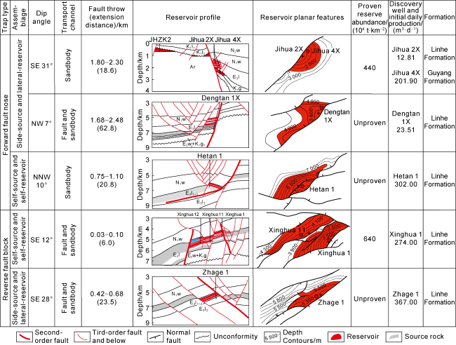
Fig. 10. Typical traps, reservoir profiles and planes, and reservoir forming characteristics. |
2.4.1. Forward fault nose trap
Large forward fault nose traps are widely distributed in the Linhe Depression. Controlled by the major second-order faults in the depression, they are located in the central and southern Jilantai and Shabu structural belts and Nalinhu faulted buried-hill belt, as well as the Guangming structure and Wulantuke structure in the northern Xinglong fault structural belt, and developed into fault nose traps. Due to the difference of stress in different zones, there are some differences in the forming mechanisms. For example, the Jihua 2 fault nose in the Jilantai structural belt which is located at the large structural transition zone between the Lang Mountain and the Bayanwula Mountain is controlled by the second-order Langshan branch fault. It is a successive fault nose after the Cretaceous Guyang Formation deposition. Affected by late strike-slip, compression, torsion and inversion [18], it has a large fault throw (1800-2300 m) and a steep stratigraphic occurrence (31°). The resulting trap is early formed (Paleogene), and the trap amplitude is high (greater than 500 m), so it is easy to accumulate oil and gas. Similarly, controlled by the structural inversion and strong extensional detachment of the Xinglong fault since the Neogene [19], the northern Guangming forward fault nose has a large fault throw (750-1100 m), and a steep stratigraphic occurrence (10°), and the resulting trap is early formed (Neogene), with a large amplitude (greater than 500 m). It is also easy to accumulate oil and gas. The Nalinhu fault nose structure is controlled by the second-order Nalinhu fault, and its formation is mainly affected by the late strong strike-slip extension. In the downthrown wall, narrow synclines and nose uplifts are developed along the strike of the fault, forming multiple fault nose structures. The Nalinhu fault nose structure has a large fault throw (1700-2400 m), and controls the Naoxi subsag. Its stratigraphic occurrence is relatively gentle (7°), and the trap is late formed (Pliocene-Quaternary). The trap amplitude is relatively small (greater than 200 m), so the degree of oil and gas enrichment is low (Fig. 10 ).
2.4.2. Reverse fault nose/block trap
The reverse fault nose/block traps in the Linhe Depression are mainly concentrated in the Xinglong fault belt, followed by the Nalinhu fault horst and the Jilantai buried hill. They are mainly controlled by third-order faults, and have the characteristics of relatively small fault throw, short extension and multiple faults controlling a trap. For example, the Xinghua structure is a typical reverse fault block trap with an area of 66 km2 and controlled by four faults. Several internal faults subdivide the Xinghua structure into three fault block traps: Xinghua 1, Xinghua 12 and Xinghua 11. The structural high is located at the Xinghua 1 fault block which is mainly controlled by Xinghua 1 east and Hangwu south faults. In particular, the Xinghua 1 east fault has a small fault throw (30-200 m), but the fault is inactive in the late stage, and the trap developed early (Miocene), which provides favorable conditions for oil and gas enrichment and accumulation. Affected by late strong extension and strike-slip, and a series of oblique reverse faults were developed in the Zhage structure and forming a reverse fault step structures. Finally, multiple rows of reverse fault block traps appeared with large fault throw (400-600 m), and steep stratigraphic occurrence of (20°). These faults had been active until the Quaternary, so the degree of oil and gas accumulation is medium (Fig. 10 ).
3. Enrichment laws and hydrocarbon accumulation models
Unique petroleum geological conditions have been developed in Linhe Depression, not only including early high-quality source rocks of saline lacustrine facies, high- quality reservoirs obviously better than other basins at the same depth and good traps, but also good source- reservoir-trap configuration, and oil and gas transport and accumulation conditions, providing important guarantee for the formation of large-scale oil and gas reservoirs.
3.1. Oil and gas enrichment law
Around-sag and near-source features are the basis of hydrocarbon accumulation in the late Hetao Basin. Due to the low geothermal gradient, long-term shallow burial, low thermal evolution and late hydrocarbon generation and expulsion in the Hetao Basin, mature source rocks in the sub-sag area are important guarantee for large-scale accumulation of oil and gas. It has been confirmed that the Xinghua reservoir, which is the closest to the hydrocarbon generation center, has the highest reserve abundance, followed by the Jihua 2X reservoir (Fig. 10 ).
High-quality and thick reservoirs are the premise of rich oil and gas accumulation in the late stage. The first and second members of the Linhe Formation in Xinglong structural belt are in the favorable facies belt of the large braided river delta front in the southeast. The sandstone-to-formation ratio is moderate, the quartz content is high, the cement content is low, the primary pores are extremely developed, and the reservoir connectivity is good, which provides favorable conditions for effective migration and accumulation of oil and gas in the reservoir. For example, although the Xinghua reservoir is buried at 4200-5600 m, the reservoir physical properties are good. The porosity is 11.2% to 18.3%, and the permeability is (3.5-531.0)×10−3 μm2. The well production is high, and even the tested oil production is up to 523 m3/d.
Good structure and trap conditions are the key to oil and gas accumulation in the late stage. It has been found that oil and gas are mainly distributed in traps controlled by second-order and third-order faults. Large faults provide favorable conditions for good structures and dominant migration channels. For example, the Jihua 2X reservoir is controlled by the structural transformation zone and Langshan branch fault, forming a large-scale forward fault nose structure near the sag. Oil and gas in the high-potential area of the sub-sag can be efficiently transported and accumulated in the low-potential area through fault noses, forming the Jihua 2X outer-source reservoir. The Xinghua 1 reservoir is generally located in the large-scale fault nose structure at the arc-shaped bend of the depression near the sag. Controlled by the Hangwu large-scale transform fault, the Xinghua 1 east reverse fault and the Hangwu south reverse fault, large-scale near-sag fault-block traps were developed. With strong hydrocarbon generation and large fluid potential caused by high-maturity source rocks in sub-sag area and large-scale forward fault on the west side of the trap in the late stage, oil and gas migrated and accumulated to the high part of the large-scale trap through the low channels on the west side of the trap, forming the Xinghua 1 reservoir with high oil abundance.
The effective configuration of source, reservoir, trap and migration is the guarantee for late oil and gas accumulation. At present, the most abundant Xinghua reservoir has been found, which has the characteristics of near source, being controlled by second-order and third-order reverse faults, good match of source and reservoir, strong oil and gas migration and accumulation, thick reservoir and high abundance. Although Jilantai Oilfield is located at the outer edge of the hydrocarbon generation center, without large faults between it and the hydrocarbon generation center, large delta sand bodies are relatively developed and extend into the hydrocarbon generation center. In addition, with large formation dip and fluid potential difference, strong oil and gas migration and accumulation, and good match of source, reservoir, trap and transport, the high-abundance Jihua 2X reservoir is formed. The Nalinhu fault nose reservoir (in Well Dengtan 1X) is also located at the outer edge of the hydrocarbon generation center, but blocked by faults and less effective transport, oil and gas enrichment and production is low although nearly a 1000-m reservoir with oil-gas show was found. Its reservoir abundance is far less than that of Xinghua 1 reservoir and Jihua 2X reservoir.
3.2. Oil and gas accumulation model
Although the Linhe Depression has the characteristics of late deep burial, late hydrocarbon generation, weak diagenesis and late accumulation, there are differences in the configuration of hydrocarbon accumulation factors and the law of migration and accumulation in different formations or different zones.
3.2.1. Accumulation in nose-uplift near sag in Jilantai structural belt
The Jilantai structural belt, which is located in the structural transition zone between Lang Mountain and Bayanwula Mountain, is a large structural transition belt where the Cretaceous and Paleogene fan delta deposits are successive. Because it is close to the hydrocarbon generation center of the Cretaceous Guyang Formation, the Cretaceous delta front sand body entered the lake and interbedded with the saline lacustrine high-quality source rock of the Guyang Formation, forming a good source-reservoir configuration. Controlled by the early extension and late strike-slip of Qinggeletu fault and Langshan branch fault, the Jilantai structural belt was reversely uplifted and denuded in the late stage, forming the Jihua 1 large buried hill trap and the Jihua 2X forward fault nose trap. Because the burial depth of Jilantai structural belt was significantly shallower, and the formation between Jilantai structural belt and the sub-sag became steeper, the secondary structure in the sub-sag was underdeveloped and the fluid potential difference was large. Combined with the above-mentioned source rocks of the Guyang Formation, the hydrocarbon generation intensity and source power are strong, and the source-reservoir configuration is good, so the sand body conductivity is strong. Since the oil and gas generated in the sub-sag area migrated from the high potential area to the Langshan branch fault in low potential area along the large nose-uplift, and then continued toward the low potential area in higher position along the fault and buried hill unconformity, forming the Jihua 1 metamorphic buried-hill reservoir and the Jihua 2X shallow Paleogene reservoir. In the Quaternary, with the gradual increase of strike-slip, compression and torsion, the vertical sealing of the Langshan branch fault was enhanced, and oil and gas from the Guyang Formation were blocked in the deep Jihua 2X Guyang Formation trap, forming the Jihua 2X Guyang Formation clastic reservoir with higher oil and gas abundance. To this end, a hydrocarbon accumulation model featured by “strong transport by fault and sand body, convergence in large nose-uplift, and multi-domain accumulation near sag” was constructed in the Jilantai structural belt (Fig. 11 ). In 2018, wells such as JHZK2 were drilled in the metamorphic buried hill, and wells such as Jihua 2X were drilled in the clastic rock of the periclinal fault nose structure on the east side of the buried hill. Major breakthroughs to oil and gas exploration were made in the metamorphic rock and clastic rock in the Archean, Guyang Formation and Linhe Formation. As a result, Jilantai Oilfield was discovered.
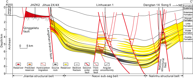
Fig. 11. Reservoir models in Jilantai and Nalinhu structural belts (section location shown in |
3.2.2. Accumulation in buried hill around sag in Nalinhu faulted buried hill belt
The Nalinhu faulted buried hill belt is located at the middle of the Linhe Depression, with the structural characteristics of “two sags and one horst”. In the early stage, it was located at the front of the large braided river delta in the east, and developed good reservoir-cap assemblages. In the late stage, a series of strike-slip extensional structures were developed under the action of regional strong extensional strike-slip, forming the forward fault nose and fault horst structures in Nalinhu structural belt. Compared with the Jilantai structural belt, except for the similar structural background, the development of large forward fault nose and buried hill fault block traps, Nalinhu structural belt is buried deep and has two hydrocarbon sources. In addition to the hydrocarbon generation center of the Guyang Formation, it is also close to the hydrocarbon generation center of the Linhe Formation in the north. With more developed faults and gentler occurrence, vertical oil and gas migration is stronger, and lateral migration may be slightly weaker. Therefore, an accumulation model featured by “two-layer dual-source hydrocarbon supply, three-dimensional transport by fault and sand body, and multi-domain convergence around the sag” was constructed (Fig. 11 ). Wells such as Dengtan1X and Jihua 19X were drilled. In 2020-2021, oil exploration breakthroughs were made in the clastic rock in the forward fault nose, and the fault-horst buried hill in the Nalinhu belt. In 2022, Well Dengtan 3 was drilled and an oil exploration breakthrough was made in the shallow Wuyuan Formation, which greatly enhanced the effective exploration potential in the Nalinhu belt.
3.2.3. Accumulation in fault nose near source rock in Xinglong fault structural belt
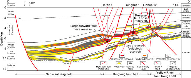
Located in the northern part of the Linhe Depression, the Xinglong fault structural belt is on the large-scale fault nose structure at the arc-shaped bend of the depression toward the sag area. It is divided into an inner zone, a middle zone and an outer zone from west to east by multiple rows of northeast-trending faults developed in the late stage. Compared with the central and southern regions, the Xinglong structural belt is deeper, the stratigraphic occurrence is steeper, and developed reverse fault blocks and fault nose traps. It is in the sedimentary center of the Linhe Formation. Close to the source and with high-quality source rocks containing high sulfur content and rich algae in the Linhe Formation, the hydrocarbon generation intensity in the Xinglong structural belt is strong. The formation occurrence is steep, and the difference of fluid potential is large, so the oil and gas transport capacity is strong. Multiple sets of regional thick mudstone caprocks such as the Wulate Formation, the third member of the Linhe Formation, and the Wuyuan Formation are developed, and the reservoir-cap assemblage is better. In particular, the Wuyuan Formation is a thick mudstone caprock (thicker than 1000 m) with mudstone-to-formation ratio of over 90%, while the sandstone-to-formation ratio of the Linhe Formation is moderate (30%-40%). When the Xinglong structural belt deposited, the water was shallow and the slope was gentle, making sand bodies widely distributed with good connectivity. In addition, the physical properties of the reservoir developed in the late weak diagenetic environment are good, further providing favorable conditions for lateral strong transport of oil and gas. Therefore, based on the strong hydrocarbon generation, high fluid potential difference, good reservoir-cap combination and physical conditions, large fault nose structures and multiple rows of traps in the inner, middle and outer zones, as well as different resource potentials caused by different thermal evolution in different zones, a late hydrocarbon accumulation model featured by “strong transportation, nose-uplift convergence and near-source enrichment” was constructed (Fig. 12 ). Risk and pre-exploration wells located in inner, middle and outer zones based on the model made major breakthroughs in middle-deep to ultra-deep oil exploration from 2020 to 2021, and Bayan Oilfield was discovered. It is confirmed that oil and gas enrichment in the middle and inner zones adjacent to the sub-sag area with mature source rocks is much higher than that in the Linhua structure in the outer zone with immature-low mature source rocks.
Fig. 12. Reservoir model in the Xinglong structural belt (section location shown in |
4. Conclusions
Through the systematic study of petroleum geological characteristics and oil and gas accumulation laws in the Linhe Depression of the Hetao Basin, it is proposed that the deposition period of the Cretaceous Guyang Formation and the Paleogene Linhe Formation was a weak extensional faulting period, with shallow water and gentle slope. Under the control of inter-mountain tectonic transition belts around the basin, (fan) braided river delta deposits were developed, forming a good source-reservoir assemblage. During the Neogene, especially the Pliocene, the basin was in strong extensional faulting period, forming a structural pattern featured by "east-west belts and north-south zones", and four large positive structural belts around sag (Jilantai, Shabu, Nalinhu and Xinglong) appeared, which provide a good background for oil and gas migration and accumulation. The Quaternary is a period of slip extensional transformation, which caused the faults in the basin more complex and the formation of small fault block traps. Two sets of saline lacustrine source rocks of the Lower Cretaceous Guyang Formation and the Oligocene Linhe Formation were developed with high content of sapropelinite (greater than 70%), rich planktonic algae and high content of reduced sulfur in organic carbon. Mature crude oil generated in the low evolutionary stage, shown by early maturity, early expulsion and wide oil generation window (4000-5000 m). The estimated hydrocarbon resources are 2 to 3 times higher than early prediction. In the Linhe Depression, except that the northern Lower Cretaceous Guyang Formation dominated by secondary dissolution pores has poor reservoir properties, the southern Guyang Formation and the Paleogene Linhe Formation dominated by primary intergranular pores have good properties. Especially, the Linhe Formation has high quartz content (50%-76%), long-term shallow burial and weak compaction, low cement content and weak cementation, and the effective reservoir depth of the Paleogene is predicted to reach 8000 m, which provides a favorable condition for near-source oil and gas exploration and greatly expands the exploration scope. Under the guidance of the reservoir models featured by "strong transportation by fault and sand body, convergence in large nose-uplift, multi- domain accumulation near sag", “two-layer dual-source hydrocarbon supply, three-dimensional transport by fault and sand body, and multi-domain convergence around the sag” and “strong transportation, nose-uplift convergence and near-source enrichment”, Jilantai and Bayan oil fields were discovered. The hydrocarbon accumulation law in the late stage of the Linhe Depression is revealed: near-source and around-sag condition is the foundation, high-quality thick reservoir is the premise, good structural background and trap conditions are key factors, and effective configuration of source, reservoir, trap and transport is the guarantee. These laws are important references for future oil and gas exploration and discovery.