

Introduction
China possesses various numerical continental oil and gas basins formed in different geological periods. During the catchment stage, there is often a concurrent occurrence of intense volcanic eruption which plays a significant role in the formation of subaqueous volcanic sediments that contribute to the filling sequence of these basins, such as the Upper Carboniferous volcanic sediments from subaqueous eruption in the Malang Depression of the Santanghu Basin [1], Paleogene volcanic sediments from subaqueous eruption in the Liaohe Basin [2], volcanic sediments from subaqueous eruption in the Batamayineishan Formation in the Junggar Basin, Xinjiang [3]. The glassy volcaniclastics resulted from magma quenching with water can easily form high-quality oil and gas reservoirs after undergoing devitrification and fluid dissolution [4]. In 2020, SINOPEC Northeast Oil and Gas Company drilled Well C2 in the Chaganhua sub-sag in the Changling fault depression in the Songliao Basin, with produced industrial gas at 10.8×10⁴ m3/d from pyroclastic rock caused by subaqueous eruption in the Cretaceous Huoshiling Formation. The discovery highlights the potential of oil and gas exploration in these types of rocks. Exploration wells, namely C3, C301, C2-1, and C2-3, exhibit a natural gas production capacity ranging from 1.3×10⁴ m3/d to 3.1×10⁴ m3/d. However, notable variations in exploration outcomes suggest pronounced heterogeneity in the physical properties, pore microstructure, and fractures of subaqueous volcanic reservoirs. Understanding the composition of subaqueous eruption facies in lake basins and developing facies models are crucial for investigating the distribution of favorable reservoirs for subaqueous volcanic pyroclastic rocks.
Subaqueous volcanic eruptions mostly occur in the vast sea [5-6]. According to incomplete statistics, there are over 500 active volcanoes worldwide, including nearly 70 submarine ones, which account for approximately one eighth. Subaqueous eruptions represent a common geological phenomenon in marine environments [7-8]. The research on subaqueous volcanic eruptions in foreign countries has achieved significant progress. In the 1980s and 1990s, various related studies were initiated, including video observation of subaqueous volcanic eruptions, field and shallow drilling for volcanic geological surveys, and experimental simulations [9⇓⇓-12]. The interaction process between magma and water during subaqueous volcanic eruptions has been extensively investigated, resulting in the development of transport and deposition models for subaqueous volcanic pyroclastic materials at different water depths and eruption intensities [13⇓⇓-16]. Subaqueous eruption at deep water is typically represented by volcanic eruptions along mid-ocean ridges. Due to the immense water pressure, internal volatiles are not easily dissolved, mainly resulting in effusive eruptions that form a plethora of pillow basalts [17]. Subaqueous eruptions in shallow water primarily generate explosive eruptions, resulting in subaqueous explosive facies [17]. White [13], Mueller [14] and Kano [15] classified the subaqueous explosive facies from shallow water eruptions into three subfacies in their study on modern subaqueous volcaniclastic deposits: gas-supported hot pyroclastic flows (GSHPF), water-logged density currents (WLDC), and subaqueous fallout (SF). SOHN et al. [10] further proposed in the study on aqueous volcaniclastic deposits on the Jeju Island, South Korea, that aqueous pyroclastic rock can be categorized into two facies associations: primary volcaniclastic facies association and secondary volcaniclastic facies association. Subaqueous explosive pyroclastic rocks belong to the primary aqueous volcaniclastics facies association, as they are directly derived from subaqueous volcanic eruptions. During the intermittent period of such eruptions, volcaniclastics were transported by water and mixed with terrigenous volcaniclastics to form sedimentary rocks that constituted to the secondary volcaniclastic facies association.
Sedimentary basins in China are the result from subaqueous eruptions occurring in lake basins [18]. The volcanic sedimentary formations resulting from subaqueous eruptions in lake basins exhibit both similarity and difference when compared to those formed by subaqueous eruptions in marine environments. The similarity is primarily manifested in the development of tuff cones. The difference lies mainly in the fact that: (1) Due to the shallower water in continental lake basins than sea basins, volcanic vents experience lower water pressure. This increases the likelihood of violent steam explosions when magma and water mix. As a result, subaqueous eruptions in lake basins lead to the fragmentation of magma into smaller glass particles, resulting in more subtle release than marine areas and a lack of particles above the ash level. (2) The fault system in continental lake basins is highly developed, with numerous magmatic channels. Although the scale of individual tuff cones is smaller than that in sea basins, their abundance and wide distribution make up for it. (3) Due to its proximity to the provenance area near the lake shore, there are numerous re-transported interbedded terrigenous volcaniclastics within the volcanic sedimentary sequence from subaqueous eruption in the continental lake basin. Therefore, subaqueous eruptions in marine environments can serve as geological models for the classification of subaqueous eruptions in continental lake basins and the development of facies models. In addition, in the investigation to the volcanic facies in terrestrial basins, subaqueous eruptions formed by direct interaction between water and magma have often been erroneously classified into "volcanic sedimentary facies" due to insufficient recognition of their unique characteristics in lake basins, as established by Wang et al.'s classification scheme consisting of 5 facies and 15 subfacies [19⇓-21]. Little did they realize that the classification scheme and facies model for volcanic rock are based solely on terrestrial volcanic rocks from the Cretaceous Yingcheng Formation in the southeastern uplift area of the Songliao Basin, and thus excluding subaqueous eruptions. The "volcanic sedimentary facies" is formed by the deposition of volcanic debris into water resulting from land eruptions. These deposits are primarily stratified and located in the far crater, exhibiting frequent interbedding between volcanic clastic rocks and normal sedimentary rocks. In contrast, subaqueous eruption within the lake basin resulted in hill-shaped deposits adjacent to the crater, exhibiting a consistent lithologic sequence of tuff, caisson tuff and pyroclastic sedimentary rock. Due to significant differences in characteristics such as origin, sedimentary morphology and sedimentary sequence, the "volcanic sedimentary facies" within the 15 subfacies of the 5 facies are not appropriate for describing and characterizing the subaqueous volcanic rock in lake basins. At present, the lack of detailed research on subaqueous eruptions in lake basins has resulted in a dearth of basis for classifying and establishing facies models of subaqueous volcanic facies in such environments. This inadequacy hinders effective guidance for exploring subaqueous volcanic reservoirs.
This study is based on five wells drilled in the Chaganhua area of the Changling fault depression in the Songliao Basin, which contain pyroclastic rock of the Huoshiling Formation caused by subaqueous eruption. Based on core data (totally 140.1 m, 18 core barrels), thin sections, geochemistry, X-ray diffraction of whole-rock clay minerals and seismic data, and comparing with the classical models of international shallow-water eruptions, a facies classification scheme and model has been established for subaqueous volcanic eruptions in the Songliao Basin.
1. Geological setting
The Songliao Basin is the largest Mesozoic continental petroleum basin in Northeast China [22-23]. The deep fault depression was formed during the Early Cretaceous period, and characterized by the development of multiple independent fault basins and large sets of volcanic sediments [22]. The Changling Faulted Depression located in the southern part of the Songliao Basin is the largest fault depression. It consists of three secondary structural units: a central sag zone, a western steep slope zone, and an eastern gentle slope zone. Additionally, there are multiple tertiary structural units such as the Da’erhan fault bulge zone and the Chaganhua sub-sag (Fig. 1a ) [24]. The Chaganhua sub-sag in the study area is situated on the upper wall of the Da’erhan fault within the eastern section of the Da’erhan fault bulge zone (Fig. 1b ). The volcanic rocks include the Huoshiling Formation (120-130 Ma) and the Yingcheng Formation (100-110 Ma) (Fig. 1c , 1d) [22]. The volcanic rock of the Huoshiling Formation was formed during the initial stage of fault depression in the Songliao Basin. A number of fault-controlled lake basins, represented by the Changling fault depression and the Xujiaweizi fault depression, commenced their formation. Some fault-controlled lake basins accumulated sedimentary layers of the Huoshiling Formation, comprising sandstone and mudstone from shore-shallow lakes and fan delta environments. During the deposition of the second member of the Huoshiling Formation, a significant volcanic event occurred in the faulted lake basin and basin margin, resulting in the formation of a lithological combination of intermediate basic lava and pyroclastic rock. The volcanic pyroclastic, sedimentary volcanic pyroclastic, and volcaniclastic sedimentary rocks formed by subaqueous eruptions in the lake basin and transported into the water at the basin margin were relatively well-developed [25] (Fig. 1d ). The Yingcheng Formation represents the period when volcanic activities were the most intense in the Songliao Basin. During the period, the faulted lake basin experienced reduction in size while completely filled with exceptionally thick volcanic rocks. The volcanic rocks consist of basalt, rhyolite, and pyroclastic rock that were erupted on terrestrial surfaces. (Fig. 1c ) [22]. The sedimentary layer of the Shahezi Formation is between the Huoshiling Formation and the Yingcheng Formation, serving as the primary source rock zone within the fault depression (Fig. 1c , 1d) [26]. At present, there are seven wells drilled within the study area (C1, C3, C301, C2, C2-1, C2-3 and YS7), which provide evidences of volcanic rock drilled in the Huoshiling Formation (Fig. 1b ). Wells C1 and YS7 are located in the relatively high zone that is mainly caused by onshore volcanic eruptions. Wells C3, C301, C2, C2-1, and C2-3 are located in the depression zone that is mainly caused by subaqueous volcanic eruptions (Fig. 1b ).
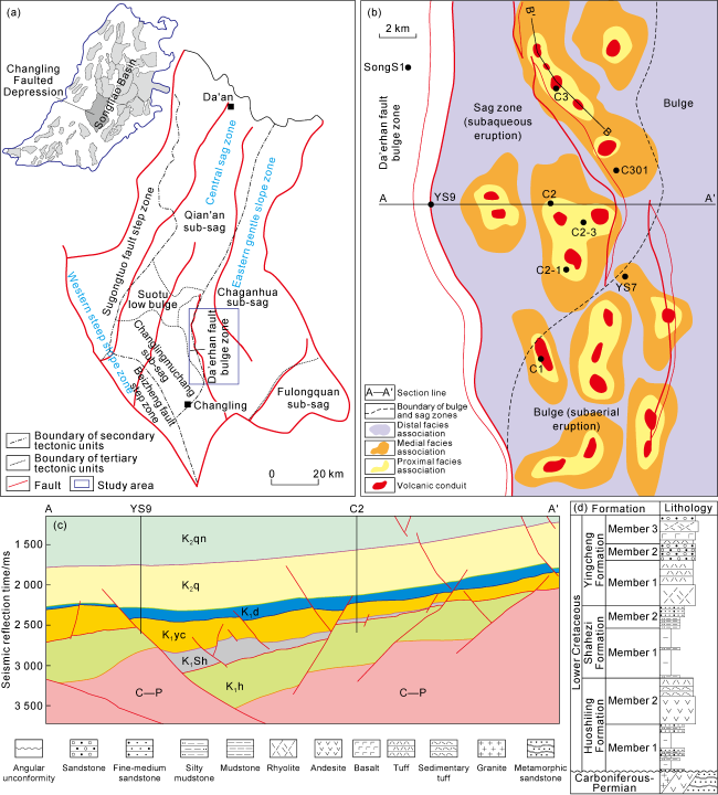
Fig. 1. Structural location, formation and volcanic edifices in the Chaganhua area of the Songliao Basin. (a) Structural zoning of the Changling fault depression and location of the study area; (b) Well locations and volcanic edifices; (c) Across-well stratigraphic profile; (d) Composite stratigraphic column during fault depression period. C—Carboniferous; P—Permian; K1h—Lower Cretaceous Huoshiling Formation; K1Sh—Lower Cretaceous Shahezi Formation; K1yc—Lower Cretaceous Yingcheng Formation; K2q—Upper Cretaceous Quantou Formation; K2qn—Upper Cretaceous Qingshankou Formation. |
2. Criteria for identifying subaqueous eruptions in the Chaganhua area
Through extensive field geological investigation to subaerial eruptive volcanoes in Northeast China, including Changbai Mountain, Wudalianchi, and Arshan, and subaqueous eruptive volcanoes such as Sunrise Peak, Seongsan on the Jeju Island in South Korea, and referring to literatures, the identifiable characteristics of subaqueous and subaerial eruptive volcanoes were compared and analyzed. The comparative analysis reveals conspicuous discrepancies between subaqueous and subaerial volcanoes in terms of volcanic rock type, volcanic edifice type, spatial distribution of eruptions, weathering degree and redox geochemical indicators (Table 1 ).
Table 1. Identifiable characteristics of subaqueous volcanic rocks |
| Eruptive environment | Type of volcanic rock | Color and structure | Volcanic edifice | Eruption distribution | Weathering | Oxidation- reduction index |
|---|---|---|---|---|---|---|
| Subaerial eruption | Various types of lava, volcanic agglomerate breccia, breccia- bearing tuff, a small amount of tuff, and sedimentary tuff | Typically grayish-white, light gray, and purplish- red; blocked and bedding in pyroclastic base deposits | Scoria cones, shield volcanoes, composite volcanoes, and calderas | Near source: thick lava, volcanic agglomerate breccia, and breccia tuff. Far source: medium to thin tuff and sedimentary tuff. | Strong weathering | A medium to high oxidation coefficient, indicating robust oxidation environment. |
| Subaqueous eruption | Tuff and sedimentary tuff, with volcaniclastic or normal sedimentary rocks | Mainly grayish-black, and locally gray; common pyrite, and vein bedding, wavy bedding, and horizontal bedding | Tuff cones | Near source: thick, fine- grained tuff and sedimentary tuff thicker than 100 m. Far source: sedimentary tuff and tuffaceous sandstone. | Weak weathering | A low oxidation coefficient indicating a highly reducing environment. |
2.1. Lithological composition
As magma erupts from the subaqueous volcano and comes into contact with a large amount of sediments rich in groundwater within the volcanic channel, complete mixing occurs between the magma and groundwater. The water dispersed in the magma rapidly vaporizes, while the superimposed magma itself volatilizes and dissolves. This leads to a rapid increase in the internal pressure of the magma, resulting in violent explosion. As a result, both the magma and the sediments within the volcanic channel are forcefully ejected, forming fine volcaniclastics that are subsequently sprayed into the surrounding water [9⇓⇓⇓⇓⇓⇓⇓-17]. Therefore, subaqueous eruptive volcanic rocks are often dominated by large sets of fine-grained tuff and sedimentary tuff, but missing lava and coarse-grained volcanic agglomerates and breccia [10]. Due to the transportation and deposition of water, sedimentary bedding is commonly formed in sedimentary tuff [10-11]. During the intermissive period of volcanic eruptions, transportation of volcaniclastics often leads to the formation of interlayered volcaniclastic sedimentary rocks [15-16]. By observing the volcanic cores of the Huoshiling Formation, it is found that wells C2, C2-1, C2-3, C3 and C301 in the Chaganhua subsag (Fig. 1d ) has a very low volcanic lava content, only 6% of basalt, and the remaining 94% are normal pyroclastic rock (37%), sedimentary pyroclastic rock (45%) and volcaniclastics sedimentary rock (12%) with fine grains (usually below 2 mm), and there is no volcanic breccia and volcanic agglomerate in all coring sections (Fig. 2a ). Based on this, core samples, cuttings and logging data were employed to classify the lithology throughout the entire wellbore (Fig. 2b ). The results indicate that the subaqueous eruptive volcanic rocks of the Huoshiling Formation in the Chaganhua area primarily consist of tuff and sedimentary tuff. These rocks exhibit the typical lithologic characteristics of subaqueous eruptive volcanic rocks.
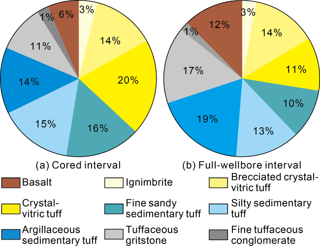
Fig. 2. Lithological composition of subaqueous volcanic rocks in the Chaganhua area of the Songliao Basin (data from wells C2, C2-1, C2-3, C3, and C301). |
2.1.1. Normal pyroclastic rock
Normal pyroclastic rock is the pyroclastic rock with volcaniclastics exceeding 90% [27]. During subaqueous volcanic eruption, volatile components within magma and water vapor from boiling groundwater mix with the magma and are expelled to the surface along with volcaniclastics, then enter the aquatic environment. Initially, water is discharged in a circumferential manner, creates a gas envelope between the volcaniclastics and the water body. This effectively prevents direct contact between the volcaniclastics and the water body, thereby delaying their mixing process [13-14]. Due to the protection of the gas envelope, volcaniclastic matters remain hot and form normal pyroclastic rocks similar to those produced by continental volcanic eruptions [15]. Three types of normal pyroclastic rocks (Fig. 2 ) were developed in the Chaganhua area, including brecciated crystal-vitric tuff (Fig. 3a , 3b), crystal-vitric tuff (Fig. 3c -3e), and ignimbrite (Fig. 3f ). Quenched breccia (Fig. 3a , 3b) [14] was observed within the brecciated crystal-vitric tuff, indicating robust interaction between magma and water resulting from rapid cooling in the aqueous environment [11]. Glass fragments resembling chicken bones (Fig. 3b ) are another type generated by the explosive eruption of magma as it ascends through volcanic conduits [28]. Additionally, a significant quantity of accretionary lapilli (i.e. volcanic ash balls) are frequently observed within these two lithologies (Fig. 3d , 3e). The accretionary lapilli are formed through the agglutination of volcanic ash, featured by a thick core and a thin outer rim (Fig. 3e ). There are two types of causes: one is the accretionary lapilli formed by continental eruptions, which occur when rainwater infiltrates the volcanic ash layer and typically accumulates on the volcanic tuff layer, forming stacked and layered structures [17]. The other is a common cause of subaqueous eruptions. Due to the high moisture content of volcanic ash in the gas envelope, it undergoes collision and agglomeration during eruption and transportation under the influence of air flow, resulting in the formation of accretionary lapilli of various sizes. The accretionary lapilli in question are typically dispersed within the tuff, spanning the entire section, with minimal interconnection observed among most of them [14,29]. In the tuff of the Huoshiling Formation in the Chaganhua area, accretionary lapilli are frequently observed to continuously develop throughout the entire cored cycle with significant thickness (Fig. 3d ), which is the characteristic of accretionary lapilli from subaqueous eruption.
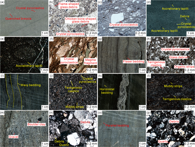
Fig. 3. Typical lithology of the Huoshiling Formation from subaqueous eruptions in the Chaganhua area. (a) Brecciated crystal-vitric tuff, 4629.3-4629.5 m, Well C3, core photos; (b) Brecciated crystal-vitric tuff, 4629.4 m, Well C3, thin section photo; (c) Crystal-vitric tuff, 4418.4 m, Well C2, thin section photo; (d) Crystal-vitric tuff with volcanic ash balls, 4627.8- 4627.9 m, Well C3, core photos; (e) Volcanic ash ball in crystalline tuff, 4627.9 m, Well C3, thin section photo; (f) Ignimbrite, 4416.9 m, Well C2, thin section photo; (g) Fine sandy sedimentary tuff, 4634.3-4634.4 m, Well C3, core photos; (h) Fine sandy sedimentary tuff, 4634.3 m, Well C3, thin section photo; (i) Silty sedimentary tuff, 4914.5-4914.7 m, Well C3, core photos; (j) Silty sedimentary tuff, 4914.6 m, Well C3, thin section photo; (k) Argillaceous sedimentary tuff, 4608.4-4608.6 m, Well C2-1, core photos; (l) Argillaceous sedimentary tuff, 4608.4 m, Well C2-1, thin section photo; (m) Fine tuffaceous conglomerate, 4527.0-4527.2 m, Well C3, core photos; (n) Tuffaceous fine conglomerate, 4527.1 m, Well C3, thin section photo; (o) Tuffaceous gritstone, 4916.1-4916.3 m, Well C3, core photos; (p) Tuffaceous gritstone, 4916.2 m, Well C3, thin section photo. |
2.1.2. Sedimentary pyroclastic rock
Sedimentary pyroclastic rock is a type of transitional pyroclastic rock that contains volcaniclastics of over 50% but less than 90% [27]. During subaqueous volcanic eruptions, volcaniclastic matters gradually mix with water, incorporating a significant amount of terrigenous clastic particles such as feldspar and quartz, as well as mud from the underlying terrigenous clastic sedimentary layer. This process results in the formation of sedimentary pyroclastic rocks [14-15]. Sedimentary pyroclastic rock formed by subaqueous eruption in the Chaganhua area is mainly fine sedimentary tuff. By referring to the grain size grading scheme of terrigenous clastic rock, the sedimentary tuff can be further refined due to the presence of a significant amount of terrigenous detritus [30], and sedimentary tuff can be further divided into fine sandy sedimentary tuff (grain size of 0.05-0.25 mm), silty sedimentary tuff (grain size of 0.005-0.050 mm) and argillaceous sedimentary tuff (grain size less than 0.005 mm). The fine sandy sedimentary tuff appears as dark gray rock with visible vein bedding in the core (Fig. 3g ). Upon examination of thin sections, it is composed of fine sandy debris ranging from 0.05 mm to 0.25 mm, including crystal debris, a small amount of plastic glass debris, and some round quartz, feldspar and other terrigenous debris. The matrix consists of volcanic dust exhibiting dim light under orthogonal polarization, and some clay minerals. Additionally, the matrix contains organic matter bands (Fig. 3h ). Silty sedimentary tuff typically is grayish-black and displays wavy bedding (Fig. 3i ). In the thin section, the rock is composed of numerous silty debris ranging from 0.005 mm to 0.050 mm, including crystal fragments and terrigenous debris exhibiting a certain degree of roundness, such as feldspar and quartz. Some argillaceous bands are visible. When observed under orthogonal polarization, the matrix is dim and has a high content of volcanic dust (Fig. 3j ). The argillaceous sedimentary tuff exhibits a nearly black core, accompanied by well-developed horizontal bedding (Fig. 3k ). It consists of a large quantity of argillaceous particles smaller than 0.005 mm. Under microscope, only a small quantity of fine silty crystal debris can be observed. The argillaceous bands exhibit significant development, and the matrix is composed of volcanic dust with a substantial amount of clay minerals (Fig. 3l ).
2.1.3. Pyroclastic sedimentary rock
Pyroclastic sedimentary rock is a transitional type of pyroclastic rock with volcaniclastics ranging from 10% to 50% [27]. Terrigenous clastic deposits are commonly believed to form interlayers of volcaniclastic sedimentary rock during eruption intervals [16]. Pyroclastic sedimentary rock in the Chaganhua area can be divided into fine tuffaceous conglomerate with grain size of 2-10 mm (Fig. 3m , 3n) and tuffaceous gritstone with grain size of 0.5-2.0 mm (Fig. 3o , 3p). The rock comprises a significant quantity of round feldspar and quartz mineral fragments, and andesite and tuff debris. Additionally, there is a minor presence of feldspar and quartz crystal fragments, and the matrix content is relatively lower (Fig. 3m -3p). The presence of pyroclastic sedimentary rock is another indicator of a water environment during the volcanic eruption in the Chaganhua area.
2.1.4. Pillow basalt
Compared to the massive pillow-shaped basalts found in mid-ocean ridges, the eruption scale of pillow-shaped basalts in continental lake basins is relatively small, and the development of pillow-shaped structures is comparatively poor [17]. In Well C2, a pillow-shaped basalt core was taken in the study area, revealing multiple curved interfaces within the core. The basalt was fragmented into multiple lenses, on which radial fractures are visible (Fig. 4 ). The presence of pillow-shaped basalt is also a characteristic indicator of a water environment during volcanic eruptions.

Fig. 4. Core photograph of pillow basalt in a continental lacustrine basin (Well C2, 4442.54 m). |
2.2. Volcanic edifice and spatial distribution of eruptions
The volcanic ash-dominated volcaniclastics resulting from violent subaqueous eruption and explosion is subjected to immense hydrostatic pressure exerted by surrounding water, thereby limiting its distribution range. It cannot disperse to form thin layers of volcaniclastics in a wide area like onshore eruptions, instead volcaniclastics accumulates around the crater to form volcanic tuff mounds thick and having a large aspect ratio [17,31]. The primary distinction between them and volcanic hills formed by continental eruption lies in the absence of lava and volcanic agglomerate breccia at the volcanic eruption center [13⇓-15]. Based on three-dimensional seismic data, multiple volcanic channels can be identified in the lower part of the mound-like reflection section of the volcanic rock in the Huoshiling Formation (Fig. 1b ). These channels exhibit disorderly and weak reflections in an inverted cone shape on the seismic profile, sandwiched between layered formations on both sides, and intersecting at a large angle (Fig. 5 ). The volcanic edifice takes the form of mounds with a high aspect ratio (for instance, in Fig. 5 , six volcanic mounds are visible on the profile across Well C3). The drilling results indicate that the lithology of the volcanic mounds, even near the crater, is dominated by tuff and sedimentary tuff with variable grain sizes, and interspersed with tuffaceous glutenite (Fig. 6 ). This composition is the typical characteristics observed in tuff mounds caused by subaqueous eruption.

Fig. 5. Volcanic edifices of the Huoshiling Formation in Well C3 of Chaganhua area (section location is shown in |
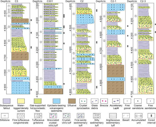
Fig. 6. Drilled lithology and lithofacies sequence in Chaganhua area. |
2.3. Geochemical indicators
OX is the oxidation coefficient of volcanic rock, defined as the ratio of Fe2O3 content to (Fe2O3+FeO) content. It serves as a crucial geochemical indicator for characterizing volcanic eruption environment. Strong oxidation environment (i.e. a high OX value) indicates terrestrial eruption and accumulation. Strong reduction environment (i.e. a low OX value) suggests subaqueous eruption and accumulation. Weak oxidation and weak reduction environment indicate terrestrial eruption and subaqueous sedimentation [18]. Liu et al. [1] enhanced the discrimination chart for the oxidation coefficient of volcanic rock by incorporating SiO2 content as a parameter to mitigate the impact of varying Fe content in volcanic rocks with diverse chemical composition ranging from basic to acidic, thereby achieving more precise discrimination outcomes. Based on this chart, the eruption environment pertaining to volcanic rocks within the Huoshiling Formation in the Chaganhua area has been successfully identified (Fig. 7 ). The research findings suggest that the oxidation coefficients of tuff and sedimentary tuff in the Huoshiling Formation belong to a strongly reducing environment, which is formed by subaqueous eruption. Additionally, subaqueous volcanic rocks are typically subject to minimal weathering due to their limited exposure to the surface after eruption [18]. CIA (Chemical Index of Alteration) is a reliable indicator that accurately reflects the degree of weathering of volcanic rocks. The higher the CIA, the more components migrate out of the volcanic rocks, and the higher degree of weathering and transformation. Volcanic rocks that undergo significant weathering and alteration typically exhibit a CIA greater than 60. Furthermore, the CIA gradually decreases from the uppermost layer to the deeper layers of volcanic rocks, resulting in a funnel-shaped curve [32]. For example, the volcanic rock in the Lishu area of the Songliao Basin, which undergoes significant weathering and alteration, typically exhibits a CIA exceeding 60 and displays a characteristic funnel-shaped morphology from its uppermost layer downwards (Fig. 8a ). The calculated CIA of tuff and sedimentary tuff in the Chaganhua area is below 60, and there is little variation from the top of the volcanic rock downwards (Fig. 8b ), suggesting that the volcanic rock has been hardly weathered. This is consistent with the characteristics of subaqueous eruption environment.
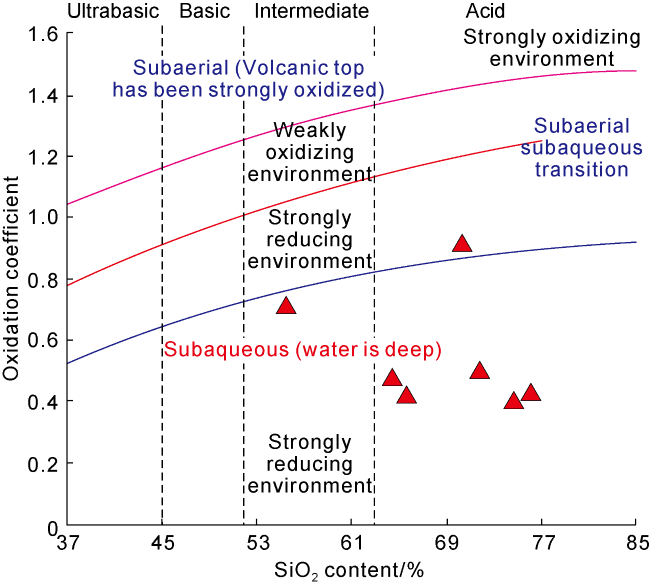
Fig. 7. Chart for distinguishing the eruption environment of Huoshiling Formation volcanic rocks in the Chaganhua area based on oxidation coefficient. |
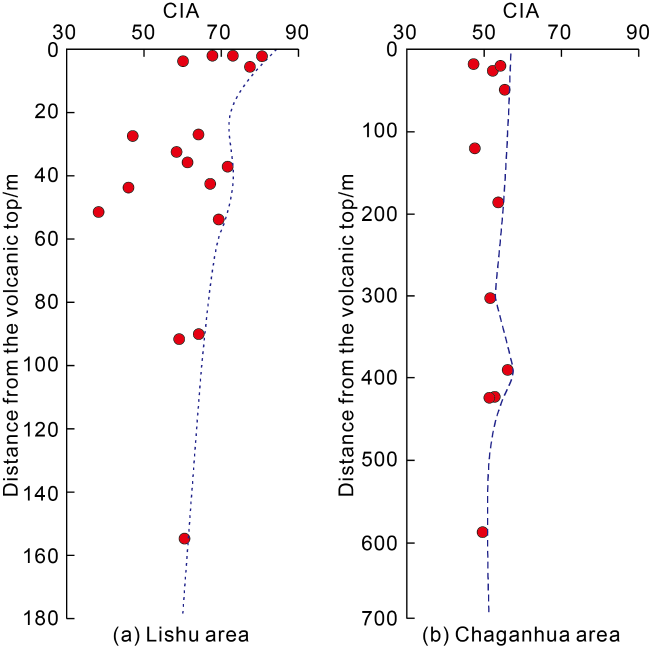
Fig. 8. Comparative analysis of vertical variations in CIA of volcanic rocks of the Huoshiling Formation in Lishu and Chaganhua areas in southern Songliao Basin. |
3. Volcanic facies and facies model of subaqueous eruption in continental lacustrine basins
According to the origin of pyroclastic rock (i.e., whether it is directly derived from subaqueous eruptions or formed through remobilization and sedimentation of volcaniclastics during eruption interval), the subaqueous eruption volcanic facies in the Songliao Basin can be classified into subaqueous explosive facies and volcanic sedimentary facies. The subaqueous explosive facies can be further divided into three subfacies: gas-supported hot pyroclastic flow (GSHPF), water-logged density current (WLDC) and subaqueous fallout (SF). Volcanic sedimentary facies is mainly epiclasts-bearing volcanogenic sediments (Table 2 ).
Table 2. Types and characteristics of the subaqueous volcanic facies in continental lake basins |
| Facies | Subfacies | Genesis | Lithology | Structure | Sequence |
|---|---|---|---|---|---|
| Subaqueous explosive facies | Subaqueous fallout | After the upper portion of the subaqueous volcanic eruption column comes into contact with water, extremely fine volcanic dust and muddy sediment agitated by the volcanic activity suspend in water and then gradually settle when the eruption becomes weak and finally stops | Argillaceous sedimentary tuff | Horizontal bedding | The uppermost section of the accumulation unit from subaqueous eruption |
| Water- logged density current | During the transportation of gas-supported pyroclastic flow, water gradually mixes with volcaniclastics and terrigenous debris, resulting in the formation of high-density gravity flow transported on the lake bottom | Fine sandy sedimentary tuff and silty sedimentary tuff | Flaser bedding, convolute bedding and wavy bedding | The central section of the accumulation unit that typically exhibits a positive trend of grain size and may comprise interbeds of fine sandy sedimentary tuff and silty sedimentary tuff | |
| Gas-supported hot pyroclastic flow | Magma is rapidly cooled and fragmented upon contact with water in the volcanic conduit, resulting in tuffaceous volcaniclastics that’s entrained by vapor and explosively ejected from the vent to form an eruption column. Encased by a gas envelope, the eruption column remains at high temperature and isolated from its surroundings before eventually collapsing and generating a pyroclastic flow similar to that from continental volcanic eruption, and transported by gas | Brecciated crystal-vitric tuff, crystal- vitric tuff and ignimbrite | Blocked, and no bedding | The lower section of the accumulation unit | |
| Volcanic sedimentary facies | Epiclasts- bearing volcanogenic sediments | Terrestrial volcaniclastics are transported into the lake and mixes with the normal sediments in the basin when volcanic eruption ceases | Tuffaceous gritstone and fine tuffaceous conglomerate | Blocked or insignificant parallel bedding | The base of the accumulation unit |
3.1. Subaqueous explosive facies
The continental Songliao lake basin is a shallow water environment [22] where subaqueous volcanic eruptions are explosive, resulting in subaqueous explosive facies (Table 2 ).
3.1.1. Gas-supported hot pyroclastic flow
The GSHPF subfacies is formed during the initial stage of subaqueous volcanic eruption. The collapse of the subaqueous eruption column, supported by gas flows and deposits along the surface under its own gravity, results in subaqueous pyroclastic flow [13⇓-15] (Fig. 9a ). The GSHPF which transports gas is primarily composed of volcanic particles and water vapor. Due to its envelopment by a water vapor film, it is effectively shielded from direct contact with water, thereby maintaining high temperature. Consequently, in the process of transportation and sedimentation, it exhibits certain similarities with the pyroclastic flow observed in onshore volcanic eruptions[13⇓-15]. Typical identifiable characteristics of GSHPF include: (1) Normal tuffaceous pyroclastic rock as the primary composition. For instance, the GSHPF in the Chaganhua area is composed of brecciated crystal-vitric tuff (Fig. 3a ), crystal-vitric tuff (Fig. 3c -3d), and ignimbrite (Fig. 3f ); (2) With the fluid properties close to gravity flow, the bedding structure is not well-developed and primarily blocked, such as the GSHPF at 4629.3-4629.5 m and 4627.8-4627.9 m in Well C3, which do not exhibit developed bedding structures (Fig. 3a , 3d); (3) Thick accretionary lapilli interval, specifically at 4627.8-4627.9 m in Well C3 (Fig. 3d , 3e). The primary difference between this subfacies and the pyroclastic flow generated by subaerial eruption lies in the grain size of pyroclastics. The pyroclastic flow from subaerial eruption is primarily composed of volcanic agglomerate/breccia or volcanic tuff containing agglomerate/breccia, while the GSHPF mainly consists of tuff with a lower content of coarse debris.
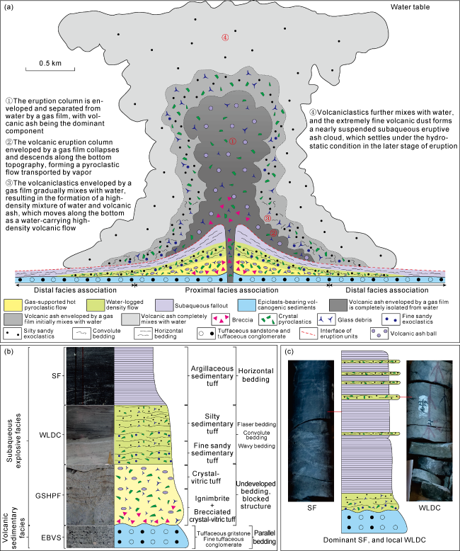
Fig. 9. Facies model of subaqueous eruption in continental lacustrine basins. (a) Subaqueous eruption process and spatial distribution of different subfacies; (b) Vertical sequence model of accumulation units within the proximal facies association; (c) Vertical sequence model of accumulation units in the distal facies association. |
3.1.2. Water-logged density current
The formation of WLDC occurs during the intermediate stage of subaqueous volcanic activity. With the increase in transport distance, water gradually infiltrates the vapor envelope and mixes with volcaniclastics, resulting in the formation of high-density turbidity current. This current is characterized by a high particle density and transported by water at the front and periphery of GSHPF, resulting in the formation of WLDC through sedimentary compaction (Fig. 9a ) [13⇓-15]. The standard identifiable characteristics include: (1) The lithology is mainly fine sandy sedimentary tuff and silty sedimentary tuff, such as the fine sandy sedimentary tuff at 4634.3 m (Fig. 3h ) and the silty sedimentary tuff at 4914.5 m (Fig. 3j ) in Well C3; and (2) The WLDC is turbidity current, and the hydrodynamic conditions are variable. Flaser bedding, wavy bedding and other sedimentary structures are present (Fig. 3g ). Lenticular and laminated vein beddings composed of finer silty and argillaceous sedimentary tuff are developed within fine sandy sedimentary tuff. Wavy bedding is observed in silty sedimentary tuff (Fig. 3i ).
3.1.3. Subaqueous fallout
The formation of the SF occurs during the later stage of subaqueous volcanic eruption. When the subaqueous volcanic eruption column rises, the upper portion gradually undergoes dispersion and mixes with water. Fine volcanic ash and muddy sediments stirred up by subaqueous volcanic eruption suspend in water, and then slowly settle and deposit after the energy of eruption weakens and eventually ceases (Fig. 9a ). When the eruption energy is high, volcaniclastic matters may eject out of water. However, due to their faster settling rate in air than in water, the ejected volcaniclastics will quickly descend back into water and mix with the suspended, resulting in their co-deposition. Typical identifiable features of this subfacies include: (1) thick argillaceous sedimentary tuff, such as that found at 4608.4 m to 4608.6 m in Well C2-1 (Fig. 3k , 3l); and (2) horizontal bedding and laminae composed of coarser silty sedimentary tuff (Fig. 3k , 3l).
3.2. Volcanic sedimentary facies
During the intermittent period of subaqueous volcanic eruptions, the re-deposition of volcaniclastic matters gradually plays a dominant role, while the volcanic rocks from subaerial eruption undergo weathering and erosion into water, forming volcanic sedimentary facies (Table 2 ). The volcanic sedimentary facies developed during the intermittent period of subaqueous eruption in the Chaganhua area is dominated by volcaniclastic sedimentary rock, with the content of extraclasts exceeding 50%. This conforms to the characteristics of epiclasts-bearing volcanogenic sediments (EBVS) [19] (Fig. 9a ). The typical lithology of EBVS consists of tuffaceous gritstone and fine tuffaceous conglomerate (Fig. 3m-3p ), exhibiting either massive bedding (Fig. 3m ) or insignificant parallel bedding (Fig. 3o ). The primary source of volcaniclastics transported in this area is the simultaneous volcanic rocks from subaerial eruptions in the bulge zones in the east and south of the Chaganhua sub-sag belt, and the Dahhan faulted bulge belt in the west. The Huoshiling Formation, which has been drilled in wells C1, YS7, and SongS1, consists of andesite, breccia, and breccia tuff from subaerial eruptions (Fig. 1b ).
3.3. Model of subaqueous eruption facies in a lacustrine basin
Based on the geological characteristics of subaqueous volcanic lithofacies, the volcanic lithofacies from five wells in the Chaganhua area is classified (Fig. 6 ). Wells C3, C2, C2-1, and C2-3 are less than 1 km from the crater (Fig. 1b ), and the vertical lithofacies sequences have relatively similar characteristics, namely multiple accumulation units resulting from subaqueous volcanic eruptions (Fig. 6 ). These accumulation units can be roughly classified into two types: one has relatively complete vertical sequences, and the other is incomplete. The accumulation units with relatively complete vertical sequence are units ①, ②, ③, ④, ⑦ in Well C3, units ②, ⑥, ⑦, ⑧, ⑨ in Well C2, units ①, ②, ③, ④ in Well C2-1, and units ①, ③, ④, ⑤ in Well C2-3 (Fig. 6 ). Some of these accumulation units are based on the EBVS with extraclastics formed during the intermittent stage of subaqueous eruptions, and then gradually transition from the GSHPF to the WLDC, with the SF as the top. The lithology is coarse tuffaceous sandstone or fine tuffaceous conglomerate, tuff (or ignimbrite), fine sandy sedimentary tuff, silty sedimentary tuff and argillaceous sedimentary tuff from the bottom to the top. As depicted in Fig. 6 , this sequence is a complete positive grain order. No volcanic sedimentary facies is observed at the bottoms of some accumulation units, indicating that the interval between the upper and the lower accumulation units is very short. The accumulation units with incomplete vertical sequence have units ④, ⑤, ⑥ in Well C3, units ③, ④, ⑤ in Well C2, and unit ② in Well C2-3 (Fig. 6 ). The GSHPF is generally underdeveloped, but WLDC and SF are developed. This phenomenon may be attributed to the limited scale of volcanic eruptions that fail to facilitate the development of GSHPF [13]. C301 is located 1.2 km away from the crater (Fig. 1b ) and exhibits a very different sedimentary sequence from the other four wells. Essentially, SF with multiple layers of WLDC is dominant, but complete subaqueous eruption sequence is hardly developed (Fig. 6 ).
The subaqueous eruption facies model in lacustrine basins has been established (Fig. 9 ). The tuff mounds formed by subaqueous volcanic eruption are typically stacked and composed of multiple accumulation units. They can be classified into proximal and distal facies associations. The facies association of tuff mounds located within 1 km from the crater belongs to near-source, and the majority of accumulation units are relatively intact. The vertical sequence of a single accumulation unit, from bottom to top, comprises the following components in order: EBVS, GSHPF, WLDC, and SF (Fig. 9b ). The distal facies association of tuff mounds is located 1 km away from the crater. As the transport distance increases, there is a gradual transition of the grain size heterogeneity in the horizontal direction from GSHPF to WLDC. Therefore, it can be inferred that GSHPF is almost missing in the distal facies association (Fig. 9a ). The vertical sequence of the accumulation units commences from the EBVS, and then the SF upward. Additionally, there exist multiple thin layers of WLDC deposits (Fig. 9c ).
4. Reservoir significance of subaqueous pyroclastic rock in a lacustrine basin
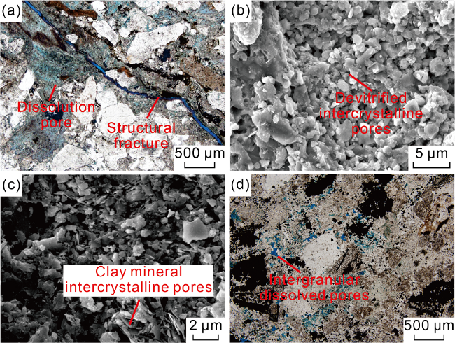
The statistical analysis of the porosity and permeability of pyroclastic rocks of different subfacies in the Chaganhua area (Fig. 10 ) indicate that the pyroclastic rocks from subaqueous eruption have low permeability, generally less than 1×10⁻³ μm2, making them tight reservoirs. Furthermore, according to the porosity, the reservoirs can be divided into those of medium porosity (higher than 5%) and low permeability (less than 1×10⁻³ μm2), those of low porosity (2%-5%) and low permeability (less than 1×10⁻³ μm2) and non-reservoir (porosity less than 2%, and permeability less than 1×10⁻³ μm2) (Fig. 10 ). The medium-porosity and low-permeability reservoir, primarily composed of GSHPF, brecciated crystal-vitric tuff and crystal-vitric tuff, is the favorable in the Chaganhua area. The reservoir space is matrix dissolution pores, devitrification pores, clay mineral inter-crystalline pores and a few fractures (Fig. 11a -11c). In addition to GSHPF, the low-porosity and low-permeability reservoir is tuffaceous gritstone and fine tuffaceous conglomerate of volcanic sedimentary facies in EBVS. The reservoir space is mainly intergranular dissolution pores (Fig. 11d ). The reservoir space of WLDC and SF remains undeveloped, exhibiting the poorest physical properties among all reservoirs, thus classifying them into non-reservoirs (Fig. 10 ).
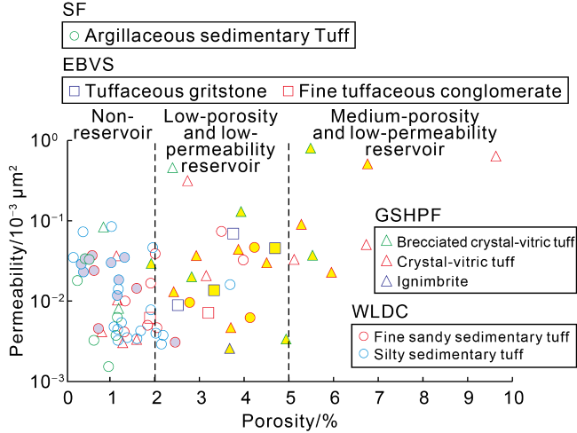
Fig. 10. Physical properties of pyroclastic rock in the Chaganhua area of the Changling faulted depression in the Songliao Basin (yellow represents gas reservoirs from logging interpretation, and the reservoir classification scheme refers to Reference [33]). |
Fig. 11. Reservoir space of pyroclastic rock from subaqueous eruption in the Chaganhua area of the Changling fault depression in the Songliao Basin. (a) Matrix solution pores and structural fractures, tuffaceous gritstone, 4528.62 m, Well C3; (b) devitrified intercrystalline pores, crystal-vitric tuff, 4442.82 m, Well C2; (c) clay mineral intercrystalline pore, crystal-vitric tuff, 4442.82 m, Well C2; (d) intergranular dissolved pores, tuffaceous gritstone, 4047.85 m, Well C3. |
5. Conclusions
The subaqueous volcanic rocks in the Songliao Basin can be classified into two facies: subaqueous explosive and volcanic sediments. The subaqueous explosive facies can be further subdivided into three subfacies: GSHPF, WLDC, and SF. The volcanic sedimentary facies consists of one subfacies, EBVS. The GSHPF is mainly normal tuffaceous pyroclastic rock with a blocked structure, undeveloped bedding, and a thick accretionary lapilli interval. The WLDC is composed of fine sandy and silty sedimentary tuff, exhibiting well-developed sedimentary structures such as flaser bedding, convolute bedding, and wavy bedding. The SF consists of thick argillaceous sedimentary tuff with horizontal bedding. The volcanic sedimentary facies contains EBVS, which is mainly tuffaceous gritstone, fine tuffaceous conglomerate and other volcaniclastic sedimentary rock, and has massive bedding or insignificant parallel bedding.
The tuff mounds formed by subaqueous volcanic eruption are usually composed of multiple accumulation units, which can be divided into proximal facies and distal facies associations. The vertical sequence of the complete accumulation unit in the proximal facies association is composed of EBVS, GSHPF, WLDC and SF from bottom to top. The accumulation unit in the distal facies association is dominated by SF, with multiple thin layers of WLDC deposits.
The pyroclastic rock generated from subaqueous eruptions typically yields low-permeability and tight reservoirs. Favorable reservoirs are predominantly developed in the GSHPF and the EBVS. The reservoir space is primarily characterized by devitrification pores, intercrystalline micropores of clay minerals, and dissolution pores. In comparison, the WLDC and the SF have not enough reservoir space, so they are not effective reservoirs.