

Introduction
Located in the South China Sea adjacent to the southeastern side of Hainan Island, the Qiongdongnan Basin is a Cenozoic rifted basin of continental margin and represents one of the key target areas for oil and gas exploration in the northern South China Sea. The basin extends in a northeast-southwest direction, and the water depth ranges from 50 m to 2 400 m now, generally shallow in the northwest and deep in the southeast. Exploration in the basin has evolved through three major phases. The first phase, before 2004, focused on shallow-water areas in the northern part (at water depth less than 300 m), and made the discoveries of the Yacheng 13-1 large gas field and several medium to small gas fields in the Yanan Sag. The second phase, from 2004 to 2020, marked a shift towards deep-water exploration, resulting in the discoveries of large deep-water gas fields like Lingshui 17-2, Lingshui 25-1, and Lingshui 18-1 in the shallow Neogene Huangliu-Yinggehai formations of the Ledong-Lingshui sags. The third phase started since 2020. As large and medium shallow targets became scarce and new breakthrough became difficult, exploration has shifted towards deeper water and strata. A deeper water and strata large gas field, Baodao 21-1, was discovered in the third member of the Oligocene Lingshui Formation (Ling 3 Member in brief) in the northern slope of the Baodao Sag. This confirms that the Baodao Sag has favorable reservoir-forming conditions and it is a key area for future exploration [1⇓-3].
The southern step fault zone located in the southern slope has been less explored than the northern slope in the Baodao Sag, and mainly studied in terms of hydrocarbon sources and structures [3-4]. Recent exploration efforts have increasingly concentrated on the clastic reservoirs, with a particular focus on the southern slope of the Baodao Sag. Unlike the northern slope adjacent to the large source area in the Shenhu Uplift, the southern slope is separated from the southern uplift by the Beijiao Sag and Changchang D subsag, and only has some small source areas in the Paleogene. Therefore, key questions related to the exploration of this area include whether reservoirs are developed, what types of reservoirs are present, and whether these reservoirs are of a significant scale. To achieve this, based on 3D seismic data, well logging data, lithology, electric logs, thin sections, and dating analysis, this study conducts paleogeomorphology restoration of the source area, fluvial system description, transport channel characterization in the sedimentary area, sand body distribution and migration pattern analysis, combined with source-sink quantitative calculations and verification to investigate the favorable reservoirs in the southern step-fault zone of the Baodao Sag. Additionally, the large delta development model of the small source area with multi-stage uplift is established, aiming to promote oil and gas exploration in the south slope and provide insights for similar structural background for petroleum reservoir studies.
1. Regional geological background
The Qiongdongnan Basin is situated at the confluence of the Pacific and Tethys tectonic domains, influenced by the Eurasian, Indo-Australian, and Pacific plates, making it one of the most active marginal sea basins on the Earth [5⇓⇓-8]. Particularly since the Neogene, the basin has been affected by tectonic events such as the South China Sea spreading and ridge jump, and subduction of the Pacific plate [9]. Drilling data indicate that two volcanically active periods of the mid-Oligocene and late Middle-Miocene led to the formation of three major erosional unconformities at mid-Oligocene (S70), late-Oligocene (S60), and late Middle-Miocene (S40) (Fig. 1 ). Accordingly, the basin evolution can be divided into four stages: the Eocene-Early Oligocene faulted stage, the Late Oligocene fault depression transition stage, the Ealy-Middle Miocene thermal subsidence stage, and the accelerated subsidence stage since the Late Miocene. The formations from the oldest to the youngest are the Eocene Lingtou Formation, the Oligocene Yacheng and Lingshui formations, the Neogene Sanya, Meishan, Huangliu, Yinggehai formations, and the Quaternary Ledong Formation (Fig. 1 ). The Lingtou Formation shows sedimentary cycles from coarse to fine to coarse grains, with grey sandstone and mudstone dominating the upper and the lower parts, dark grey mudstone, shale and oil shale in the middle part. The Yacheng and Lingshui formations exhibit a cycle of coarse grains at the bottom and fine grains at the top, which are grey sandstone interbedded with mudstone in the lower part and grey mudstone interbedded with thin layers of sandstone in the middle to upper part. Among them, the Yacheng Formation contains a few thin coal seams in some areas, while the Lingshui Formation has a few limestones in some areas. Since the Neogene, the basin has experienced rapid marine transgression. The differences in formations are not significant, and mainly consisting of gray marine mudstone. However, in different areas like delta, submarine fan, and canyon channel, the grain size of the sandstone is different. Additionally, limestone and biolimestone are present in some uplifts and other areas.
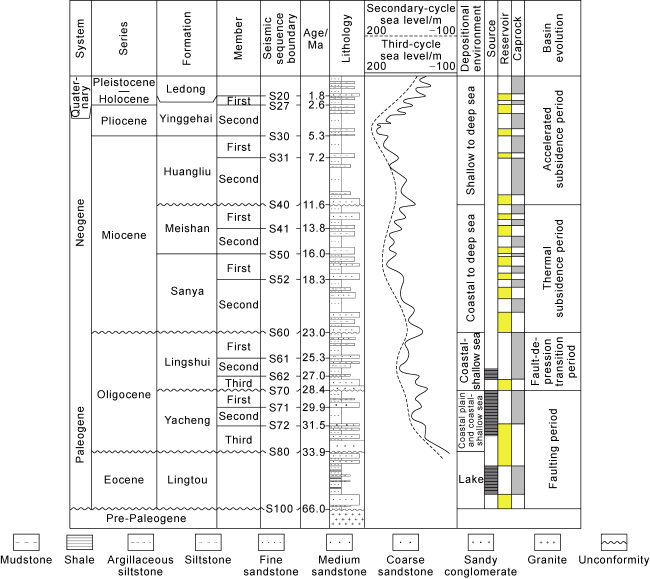
Fig. 1. Comprehensive stratigraphic column of the Qiongdongnan Basin. |
During the Paleogene, the fault system in the basin was well developed, with stratigraphic distribution relatively confined. Influenced by faulting, a structural pattern of multiple uplifts and depressions emerged. From north to south, the basin can be divided into four primary tectonic units: the northern depression zone, the central uplift zone, the central depression zone, and the southern uplift zone. The central depression zone, extending from west to east, comprises secondary structural units including Ledong Sag, Lingnan low bulge, Lingshui Sag, Beijiao Sag, Songnan low bulge, Songnan Sag, Baodao Sag and Changchang Sag, etc. [10] (Fig. 2a ).
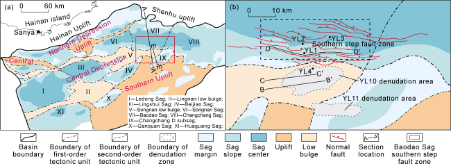
Fig. 2. Tectonic division of the Qiongdongnan Basin (a) and the southern step fault zone in Baodao Sag (b). |
The southern step-fault zone of the Baodao Sag is located at the junction between Baodao-Changchang sags and the eastern part of Songnan low bulge. Although it is adjacent to the Songnan low bulge in terms of structural location, this low bulge began to gradually submerge during the depositional period of the Yacheng Formation. Until the Lingshui Formation deposition period, only some source areas like YL10 and YL11 denudation areas remained as "isolated islands", while large source areas were missing in the surrounding region (Fig. 2b ).
Drilling in the YL10 denudation area has revealed that although the source areas are small in scale, it is different from other major source areas such as the Shenhu Uplift and the Southern Uplift which are predominantly characterized by Yanshanian granite. In the YL10 denudation area, the basement of the source area found in Well YL4 contains zircon with U-Pb age of approximately (239.50±0.93) Ma, indicating Indosinian granite. Additionally, core samples from Well YL4 show significant signs of feldspar argillization and fractures, indicative of intense weathering process. Moreover, structural studies have demonstrated that the area has been influenced by clockwise rotation of the regional stress field and multiple phases of tectonic activities, resulting in notable local structural deformation and uplift, and consequently, at the end of the deposition of the Yacheng and Lingshui formations, two major erosional unconformities appeared. Analysis of the fault system in the study area reveals three groups of faults. The early-stage faults are primarily northeast-trending and predominantly boundary-controlling faults, which significantly influenced the Lingtou and Yacheng source rocks. The mid-stage faults, mainly oriented nearly east-west, predominantly controlled the Lingshui Formation. The late-stage faults, primarily northwest-trending, had a less apparent impact on sedimentation and were mainly active from the Early to Middle Miocene. During the deposition period of the Lingshui Formation, the study area was mainly influenced by the boundary-controlling faults and the nearlyeast-west trending faults. From south to north, a series of nearly east-west step faults were formed, particularly during the deposition of the Ling 3 Member, which exhibits a typical multi-step fault structural pattern (Fig. 3 ). This study indicates that the southern step fault zone of the Baodao Sag possesses favorable conditions for hydrocarbon accumulation. The thicknesses of the Eocene-Yacheng Formation source rocks reaches up to 2 500 m, making it a center of hydrocarbon generation in the southern part of the Baodao Sag. The step faults are large and directly connect with the source rocks, serving as important migration channels for oil and gas. Additionally, multiple structural ridges and favorable oil and gas accumulation background further enhance the exploration potential.

Fig. 3. Typical seismic profile of Baodao Sag (see the section position in |
2. Source-sink system
Recent sedimentological research has increasingly focused on analyzing source-sink systems, which play a crucial role in understanding the development of clastic reservoirs like deltas. Many domestic scholars have systematically summarized the fundamental concepts, conceptual frameworks, research methodologies, and development directions of this field [11⇓⇓⇓-15]. Among them, studies on provenance systems, transport systems, and depositional systems are the key contents in researching source-sink systems [16-17]. The southern step fault zone adjacent to the YL10 denudation area has been extensively studied to restore the paleogeomorphology and fluvial systems of the source area, characterize the sediment transport channels, and investigate the distribution and migration patterns of sand bodies. These studies have clarified that during the depositional period of the Ling 3 Member, large-scale deltaic reservoirs had been developed.
2.1. Restoration of the paleogeomorphology and fluvial systems in the source area
During the depositional period of the Ling 3 Member, the southern step fault zone in the Baodao Sag experienced intense tectonic activities along the nearly east- west trending faults, resulting in a series of small grabens which impeded the transport of sediments from denudation areas such as the southern uplifts, and consequently, the primary source of sediments was from the YL10 denudation area. Drilling data has revealed that the basement of the YL10 denudation area primarily consists of Indosinian granite. Towards the end of the deposition of the Yacheng Formation, the region was influenced by a rotational, compressional and torsional stress field, causing noticeable local uplift and folding deformation in the Yacheng Formation and earlier formations. During the deposition of the Lingshui Formation, a gradual planation process occurred, leading to extensive erosion of the Yacheng Formation, especially in stress-concentrated areas like the western side of the denudation area (Fig. 4a , 4b ), ultimately resulting in the present-day topography characterized by high elevations in the middle and lower elevations around. Hence, the geomorphologic features during the Ling 3 Member depositional period are markedly different from the present structural morphology in the YL10 denudation area. The restoration of the paleogeomorphology and fluvial systems of the source area must be based on the reconstruction of ancient tectonics.
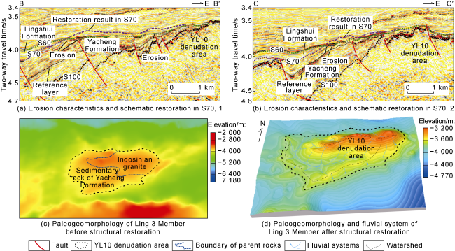
Fig. 4. Erosion characteristics and restoration in S70, paleogeomorphology of Ling 3 Member before structural restoration, and paleogeomorphology and fluvial system after structural restoration (see the section location in |
The restoration of the ancient tectonics of the denudation area is primarily based on three-dimensional seismic data. This involves an analysis of the structural morphology, strata occurrences and erosion characteristics in the study area. By employing the stratigraphic thickness trend method, and focusing on the identification of the erosion phenomena and extent of the key sequence boundary S70, this approach integrates the occurrence of the underlying strata and their seismic characteristics to select a reference layer, and then reconstruct the paleogeomorphology of the YL10 denudation area during the Ling 3 Member depositional period (Fig. 4c , 4d ). This is achieved by considering the occurrence of the reference layer and the trend of the strata that become thinner and pinch out towards the denudation area. The results indicate that during the Ling 3 Member depositional period, the total area of the YL10 denudation area was approximately 235 km², overall exhibiting an elliptical shape. The western part, influenced by the compressive stress resulting from the clockwise rotation of the regional stress field between the faulted period and the fault-depression transition period, developed a northwest-trending folding mountain system. This mountain system obstructed the westward-flowing streams in valleys, making them to converge northward into the Baodao Sag through inclined slopes or valleys formed by earlier faults, thus establishing the largest fluvial system. The other fluvial systems were predominantly small, and dispersed along the valleys towards the periphery. On this basis, watersheds were further delineated based on the restored paleogeomorphic ridgelines, and drainage areas were defined by watersheds and geomorphic troughs. Fluvial systems with inlets at the same location were categorized into a provenance system, thus two main fluvial systems, east and west, were identified in the YL10 denudation area. The western provenance system controlled by earlier anticline geomorphology and valleys had well-developed tributaries and a dendritic pattern, relatively larger in scale and with the longest stream approximately 23.8 km and a drainage area of about 168.5 km². It covered most of the sediments from the denudation area, with parent rocks including both Yacheng Formation sedimentary rock and Indosinian granite. The eastern provenance system, primarily influenced by valley geomorphology, had less developed tributaries and a single-branch pattern, smaller in scale but with a larger overall terrain gradient. Its drainage area was about 26.5 km², where granite was the dominant parent rock.
2.2. Characterization of sand transport channels in sedimentary area
Based upon the detailed identification and characterization of the fluvial systems in the source area, the seismic response characteristics of the delta around the sediment input points were studied. The research revealed that around the two northward-flowing provenance systems in east and west, two dominant sand transport channels were formed in the southern Baodao Sag. These channels respectively controlled the development of two delta lobes in the east and west, with the overall characteristic of being larger in the west and smaller in the east. In the direction perpendicular to the provenance (Fig. 5 ), the two lobes merged into a mound-shape. The dominant sand transport channel of the western lobe exhibits more pronounced characteristics of downcutting erosion, characterized by medium frequency, medium to strong amplitude, and more continuous to continuous seismic reflections. Influenced by the fluvial system, its scale is significantly larger. In contrast, the dominant sand transport channel of the eastern lobe is controlled by faults in some areas, with less distinct downcutting erosion features, and characterized by more continuous seismic reflections with medium frequency and medium amplitude. Compared to the western lobe, the hydrodynamic force in the eastern lobe is relatively weak, the lobe scale is smaller, the thickness is thinner, and the early sand body is not developed.
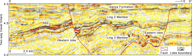
Fig. 5. Profile of delta lobes in vertical direction of provenance in sedimentary area (see the section location in |
Structural characteristic analysis reveals that under the background of multi-stage forward step faults, fault activity significantly controls the sand transport channels between different step faults [18]. The study indicates that the intensely active sections of sedimentation-controlling faults are favorable for the development of dominant sand transport channels. In the southern step fault zone of the Baodao Sag during the deposition of the Ling 3 Member, statistical analysis of the growth index of sedimentation-controlling faults (Fig. 6a ), such as F10-1, F1, F1-1, F2, reveals that F10-1 was strong active on the north side of the sediment input point near the source area, and its central section was the most active and can be subdivided into two closely spaced segments with intense activity in the east and west. F1 was strong active in its central section. F1-1 was strong active at its junction with F2. F2 was strong active in the western part of the middle section. Controlled by the activities of these faults on the planar, the western delta lobe primarily advanced northward along the intensely active segments in the western part of F10-1 and F1. In contrast, the eastern lobe mainly progressed northward along the intensely active segments in the eastern part of F10-1 and F2. This distribution pattern is evident on the root-mean-square (RMS) amplitude attribute and thickness maps where areas of strong amplitude and thicker sand bodies align with the forementioned channels (Fig. 6b ). Additionally, it's noteworthy that due to the northeastward turn of the eastern segment of the F1 fault, the fault trough formed by intense activity also significantly controls the lateral transport of the sand bodies.
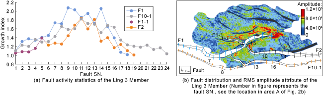
Fig. 6. Fault activity statistics, fault distribution and RMS amplitude attribute of the Ling 3 Member. |
2.3. Distribution and migration patterns of the deltaic sand bodies
Based on the characteristics of delta seismic response, regional petrophysics and seismic calibration from the near-source well YL1, the Ling 3 Member delta is divided into four stages vertically. The distribution and migration law of the sand bodies are characterized (Fig. 7 ). The first stage corresponds to the initial development of the delta, with a limited distribution area, with only western lobe developed (Fig. 7a ). The main area exhibits medium to strong amplitude and weakly continuous reflections on the seismic profile, suggesting a development zone of underwater distributary channels at the delta front, which covers about 77 km². The peripheral area which shows relatively weaker amplitude and is thinner on the seismic profile is continuously traceable from the main area, so it is inferred to be a sheet sand development zone at the delta front, and covers about 51 km². The second stage marks the prosperity of the delta, with a larger distribution range. Both the eastern and the western lobes developed, but the western one was significantly larger (Fig. 7b ). Based on seismic phase characteristics and interpretation, the development area of underwater distributary channels in the western lobe is estimated to be about 128 km² and about 78 km² in the eastern lobe. The sheet sand development zones at the front of both lobes merges into one, and covers a total area of about 294 km². The third stage represents the intermittent development of the delta, when the scale of the sand bodies in both lobes noticeably decreased (Fig. 7c ). The development area of underwater distributary channels in the western lobe is estimated to be about 50 km² and about 37 km² in the eastern lobe. The total area of the front sheet sand development zone is about 82 km². The fourth stage is the rejuvenation of the delta, when the scale of the delta expanded again (Fig. 7d ). The total area of the development zone of underwater distributary channels is about 231 km², and the total area of the front sheet sand development zone is about 235 km².

Fig. 7. Overlay of the amplitude attribute of sand bodies in four stages with paleogeomorphology of the Ling 3 Member. |
Vertical comparison reveals that the largest scale of the delta occurred during the prosperity and rejuvenation periods. The SN-trending advance was primarily controlled by the input point of the fluvial system and fault activity, generally from south to north. Notably, the northern F1 fault, due to its northeastward orientation in the eastern segment, also influenced the advancing direction of sand body through the fault troughs. On a planar level, there was a tendency for the sand bodies to gradually migrate eastward over these four stages. This shift is largely attributed to the overall topography of the Baodao Sag being higher in the west and lower in the east, with the maximum subsidence center located in the eastern part. Due to the filling and leveling effects of early sand bodies, the low-lying zones progressively shifted eastward, causing the delta lobes to move eastward, especially during the rejuvenation period, when the western lobe noticeably shifted eastward along the fault trough.
3. Quantitative analysis of source-sink system
Quantitative research on source-sink systems in sedimentary basins has become one of the forefront fields in sedimentological study in recent years [14,17,19⇓⇓⇓⇓ -24]. This approach primarily involves quantitative investigation to internal and external influences on various elements within the system [13]. The aim is to further validate the rationality of sedimentary system analysis and characterization, and significantly enhance the precision of reservoir prediction. Based on this concept, further quantitative analysis and validation on source-sink coupling were conducted to assess whether the YL10 denudation area could provide sufficient material supply for the Ling 3 Member delta.
3.1. Principles and methods
The fundamental principle of quantitative research on source-sink coupling is the law of conservation of matter. This law posits that the detrital materials produced by weathering and erosion in the source area must accumulate in a specific process and manner, either locally or distally, and they do not spontaneously generate or annihilate [11]. Therefore, based on the characterization of the features and distribution area of parent rock, and fluvial system in the source area, and the developmental stages and distribution of sand bodies, the volume of sand bodies in the sedimentary area and the erosion amount in the source area were calculated to ascertain whether the source area can provide sufficient material and further clarify whether the corresponding seismic anomalous body is a large reservoir.
The characterization of the source area and parent rock features is primarily based on 3D seismic data. Sequence boundary tracking is used to establish the boundary of the sedimentary area and the range of the denudation area. Due to multiple phases of tectonic uplift, earlier erosion also brought sediments for the Ling 3 Member. Thus, within the denudation area, the distribution ranges of granite parent rock and sedimentary parent rock were determined based on the contact relationship of different sequence boundaries and seismic phase characteristics. The size of the source area and fluvial system were mainly characterized based on the results of paleogeomorphology restoration (Fig. 4d ). The delineation of ancient fluvial systems helped to determine the source area. The distribution and thickness of sand bodies were ascertained based on the phased characterization of the delta by employing methods such as attribute characterization and anomaly tracking.
3.2. Quantitative calculation process
Employing the forementioned methods and software such as DSG and Petrel, and based on drilling data, sedimentary microfacies and thickness distribution, this study specifically addressed the identification of four stages of sand bodies of the Ling 3 delta within the YL10 denudation area. The area of development zones of underwater distributary channels and sheet sand, flattened thickness in the delta front were determined (Table 1 ). The formula for calculating the volume of sand bodies in the sedimentary area is as follows:
$V=\sum\limits_{i=1}^{4}{\left( {{a}_{i}}{{H}_{i}}+{{b}_{i}}{{h}_{i}} \right)}$
Table 1. Parameters of sand bodies in four stages of Ling 3 Member delta |
| Stage | Development area of underwater distributary channels/km2 | Flattened thickness of underwater distributary channels/m | Development area of sheet sand/km2 | Flattened thickness of sheet sand/m |
|---|---|---|---|---|
| Stage 4 | 231 | 26 | 235 | 6 |
| Stage 3 | 87 | 23 | 82 | 7 |
| Stage 2 | 206 | 24 | 294 | 6 |
| Stage 1 | 77 | 31 | 51 | 7 |
Based on the volume of the sand body in the sedimentary area, it is possible to back-calculate the average erosion thickness of the denudation area. The calculation formula is as follows:
$H=\frac{V}{{{S}_{1}}{{f}_{1}}+{{S}_{2}}{{f}_{2}}}$
Based on the fluvial systems characteristics and parent rock types of the YL10 denudation area, the areas of the granite parent rock and sedimentary parent rock zones are 0.80×10⁸ m2 and 1.15×10⁸ m2, respectively. Moreover, Well YL4 reveals that the granite primarily comprises hornblende biotite plagioclase-granite and monzogranite, both rich in minerals such as quartz and feldspar. The quartz content ranges from 30.0% to 53.5%, with an average of 38.4%. The content of potassium feldspar and plagioclase ranges from 44% to 66%, and averaged 55.2%. In contrast, Well YL1 in the sedimentary area reveals that the Ling 3 delta is predominantly composed of very fine to fine feldspathic quartz sandstone with moderate sorting and sub-angular to sub-rounded grain shape. The quartz content varies between 43% and 63%, averaging at 51.5%. The feldspar and lithic content ranges from 27% to 32%, with an average of 29.9%. The mud content ranges from 1% to 10%, averaging at 5.8%. Given that quartz is resistant to weathering, and feldspar can weather into clay after fracturing, it is estimated that about 20% of the total volume of unstable minerals like feldspar has been lost during transport. Consequently, the sand-forming coefficient for granite in this area is set at 0.8. Drilling data reveals primarily proximal deltaic deposits of sandy conglomerate and coarse sandstone with conglomerate in the Yacheng Formation in the denudation area. The conglomerate mainly consists of quartz-pebble conglomerate and felspathic conglomerate, with a sand-to-strata ratio reaching 84%. Considering the loss of sandstone during the sedimentary process, the sand-forming coefficient for the sedimentary rock in denudation area is set at 0.6.
3.3. Results and validation
According to Eq. (1), the volume of the deltaic sand body in YL10 area is approximately 194.43×10⁸ m3, and the average erosion thickness of the denudation area, calculated by Eq. (2), is about 146 m. To determine whether the YL10 denudation area can provide sufficient erosion volume, the erosion volume of the lower Yacheng Formation in the denudation area was restored using the stratum thickness trend method. The results show that the maximum erosion thickness of the Yacheng Formation in the western part of the denudation area may reach 165 m. Although the eastern granite denudation area has strong weathering resistance, based on the paleogeomorphology restoration results, as an inherited basement denudation area, its elevation is significantly higher than that of the western sedimentary parent rock denudation area, suggesting more pronounced downcutting erosion process. Therefore, it is estimated that the erosion rate of the granite area is not less than that of the western sedimentary rock area. Moreover, in YL11 denudation area, which is on the south of the YL10 area and having the similar tectonic background, also developed significant uplifts during Ling 3 Member sedimentary period. The uplifting caused notable erosion to the Yacheng Formation while forming a small fan delta in the steep slope zone (Fig. 8 ). Restoring the erosion volume of the Yacheng Formation in this area using the stratum thickness trend method revealed that the maximum erosion thickness in YL11 denudation area could reach about 400 m. Consequently, it is speculated that the erosion thickness of the granite area in YL10 denudation area during Ling 3 Member sedimentary period may exceed the erosion thickness of the Yacheng Formation in the lower part of the denudation area, and may reach several hundreds of meters. Therefore, given a fixed source area, larger erosion thickness implies more abundant source supply and a larger scale of sand body. Based on this, it is believed that the source supply from the YL10 denudation area can fully meet the need of deltaic sand bodies predicted at present.

Fig. 8. The northwest-southeast seismic profile through YL10 and YL11 (see the section location in |
4. Deltaic deposition
The study on the source-sink system of the Ling 3 Member in the southern step-fault zone of the Baodao Sag has clarified the material basis for the formation of large scale delta in this area. Based on this understanding, wells YL2 and YL3 were drilled relatively far from the source area of the northern step fault zone, confirming the potential for large reservoirs to develop even in small source areas in the Paleogene of the southern Baodao Sag. Presently, based on the existing three wells in this area, the depositional characteristics of the delta are introduced as follows.
Drilling data has revealed that the delta of the Ling 3 Member in the southern step fault zone is primarily composed of light grey fine sandstone with few grey argilliferous sandstone and siltstone intercalations. The total thickness of the sandstone ranges from 109 m to 138 m, the maximum layer thickness is between 15.5 m and 30.0 m, and the sand-to-strata ratio is 43.7% to 73.0%. The grains are moderately to better sortable, and almost sub-rounded to sub-angular. Sidewall cores reveal a variety of sandstone structures, mainly shown massive bedding, along with parallel bedding and small-scale cross-bedding, indicating predominantly tractive flow conditions. The main planar structures are erosional surfaces, with light grey fine sandstone above and brownish-grey mudstone below. Torn mud strips and mud clasts were found, indicating locally strong hydrodynamic conditions during sedimentation.
The reservoir physical properties of the delta are obviously different among different step faults. For instance, in Well YL1 at 4 099-4 277 m, the grains are mainly in point-line contact, with intergranular pores, good pore connectivity and weak dissolution. The measured porosity ranges from 11.7% to 27.2%, with an average of 21.4%, and the average permeability is 77.8×10⁻³ μm², indicating a reservoir of medium to high porosity and permeability. On the other hand, in Well YL2 at 4 880-5 300 m, the grains are primarily in line contact, and with pressure-induced cementation. The cements consist mainly of micrite and powdered crystalline ferrocalcite, iron dolomite and siderite, with dominantly secondary pores, such as moldic pores. The measured porosity ranges from 11.9% to 22.1%, with an average of 17.6%, and the average permeability is 0.5×10⁻³ μm², indicating a reservoir of medium porosity, and low to ultra-low permeability.
The sandstone in the delta primarily consists of fine grains, with median grain size ranging from 110 µm to 240 µm. The cumulative probability grain size distribution curve of 42 samples from the sidewall coring mainly shows a two-stage pattern with a high slope, almost jumping and suspending components, and undeveloped rolling components. The content of the jumping component ranges from 50% to 60%, and the suspending component ranges from 40% to 50%. The value of ϕ at the intersection of the jumping and the suspending components is between 2.5 and 3.0. These grain size characteristics and C-M plot suggest that the dominant hydraulic conditions were associated with moderate tractive currents, which are common in sedimentary environments like underwater distributary channels and mouth bar.
Logging data reveals that the Ling 3 Member delta as a whole exhibits an inverse cyclical. The lower part is relatively clay-rich, and dominated by shallow marine and pro-delta sedimentation, while the upper part is relatively sand-rich, and dominated by delta front sedimentation. For instance, within the Ling 3 Member delta found in Well YL2, the lower part is characterized by mudstone, silty mudstone interbedded with thin layers of fine sandstone, etc. Logging curves mainly show high gamma-ray, low resistivity and high density. The gamma- ray log is generally in a low-amplitude sawtooth shape, with finger shape intercalations, indicating mainly shallow marine and pro-delta sedimentation, with local development of outer edge sedimentation of delta front. The upper part is characterized by interbeds of fine sandstone and mudstone, silty mudstone, it can be divided into four upward-fining cycles corresponding to four stages of deltaic sedimentation. The sandstone mainly exhibits low gamma-ray and low density values in logging data. The gamma-ray curves are in various shapes, such as box, bell, finger and funnel, indicating sediments of underwater distributary channels, mouth bars, sheet sands and interdistributary bays (Fig. 9 ). Notably, the box-shaped and serrated box-shaped curves, which reflect sediments of underwater distributary channels at the delta front, are well developed, and often with abrupt changes at the base, revealing the erosional impact of single or multiple underwater distributary channels on the underlying strata.
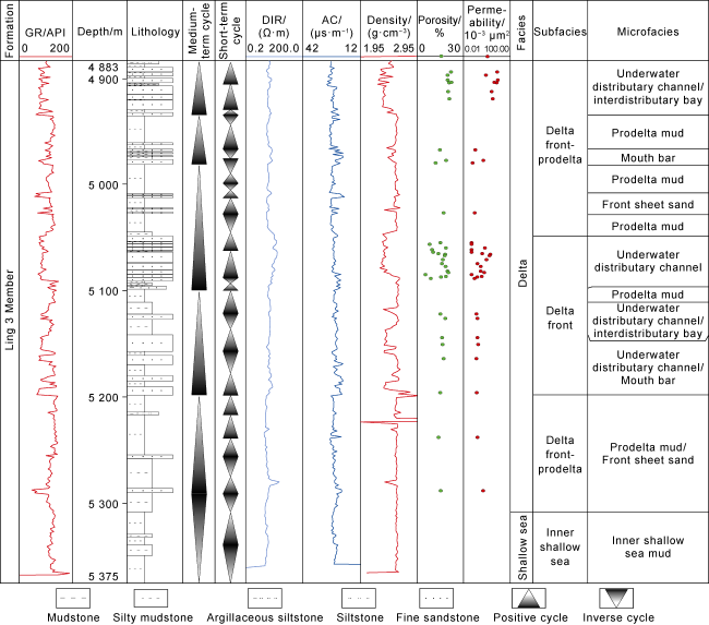
Fig. 9. Sedimentary facies of the Ling 3 Member in Well YL2 (GR—gamma ray, DIR—deep array induced resistivity, AC—acoustic time). |
5. Delta formation mechanisms
Research on the source-to-sink system and drilling data confirmed that although the YL10 denudation area in the southern step Fault zone of the Baodao Sag had a relatively small source area during the Ling 3 Member sedimentary period, it was significantly influenced by tectonic episodic uplifting, the geomorphology of the source area, and active faults in the step fault zone, so sufficient sources can be provided which promoted the formation of large-scale delta reservoirs. Through a comprehensive analysis of the delta forming mechanism, a large delta development model based on multi-stage uplifting and the small area with multi-stage uplift was established.
5.1. Episodic uplifting provides sufficient sediments
As mentioned earlier, after the deposition of the Yacheng Formation in the YL10 denudation area, it was influenced by the regional stress field which gradually changed from early northwest-southeast extension to near north-south extension in clockwise rotation. This change in the stress field has two major impacts on the area. First, it caused oblique slip of early northeast-oriented faults and northwest-oriented hidden faults, creating stress concentration zones in some area. This resulted in folding and uplifting of earlier strata and created conditions for later erosion and transport, particularly influencing the sedimentary parent rock area on the west side of the YL10 denudation area. Second, it led to intense activities along east-west trending faults, especially the strong activity along the depression-controlling fault, causing rotation and tilting of fault blocks. This further resulted in uplifting and eroding at the top of the gentle slope zone, particularly obvious in the YL11 denudation area. It is inferred that the YL10 denudation area, which has a similar structural background, also experienced significant uplifting. It's important to note that during the adjustment of the stress field, the fault activity primarily exhibited episodic characteristics, with intense uplift and erosion during the depositional period of the Ling 3 Member, leading to the formation of fan deltas in the steep slope zone. In contrast, during the depositional periods of the Ling 2 Member and the Ling 1 Member, fault activity was weakened, and uplifting was less pronounced, resulting in reduced source supply.
5.2. Fluvial system and area control the scale of sand bodies
Studies have shown that the area of ancient valleys and their connected source areas, as well as the type of parent rock, are fundamental factors that control the size of sedimentary bodies [25-26]. Granite, metamorphic rock and clastic rock as parent rocks tend to form contiguous large-scale reservoirs, while carbonate rock often results in smaller isolated reservoirs [27]. During the depositional of the Ling 3 Member, the YL10 denudation area was primarily developed two major fluvial systems, which controlled the formation of two deltaic lobes. The western fluvial system, influenced of anticlinal topography formed by local compression, had a larger watershed area of approximately 168.5 km2, accounting for 71.7% of the total denudation area. The predominant parent rocks were Indosinian granite and Yancheng Formation sedimentary rock. Consequently, the deltaic lobe on the western side was larger, and the maximum underwater distributary channel area was up to 186 km2, which extended toward the center of the Baodao Sag by a maximum distance of 23.5 km. Drilling results revealed that the maximum single-layer thickness of sediment reached 30 m. On the eastern side, although there was a significant drop in elevation, the watershed area was much smaller, approximately 26.5 km2, accounting for 11.3% of the total denudation area. The deltaic lobe on the eastern side was notably smaller, and the maximum underwater distributary channel area was approximately 78 km2. It extended up to a maximum distance of approximately 15.2 km. The latest drilling data has only revealed the distal portion of the delta front, with a maximum single-layer thickness of sediment as 12 m.
5.3. Multi-step active faults control the direction and dominant transport channels of sand bodies
In the southern step fault zone of the Baodao Sag, several nearly east-west trending faults are developed. During the depositional of the Ling 3 Member, the strong activity of these faults under the influence of nearly north-south extensional stress significantly controlled the dominant sand transport channels. As a result, the dominant sand transport channels of two delta lobes, east and west, in the Ling 3 Member were both characterized by northward pushing along the strongly active fault segments, so that the sand bodies became thick in the footwalls of the faults, like mound shaped body with bidirectional downlap and gradually decreasing thickness. Furthermore, compared to the eastern delta lobe, the sand transport pathway of the western delta lobe was also controlled by the inner concave fault embayment toward the source area. Analysis suggests that this inner concave fault embayment often exhibits strong sand accumulation effect due to its topographical orientation toward the source area, often appearing as a channel extending toward the source area. The sediments can converge and be transported to the footwall along the slope of the fault surface [28]. For example, within the inner concave fault embayment of the F10-1 and F1 faults, erosion features formed by strong hydrodynamic process are commonly observed in the hanging wall, while the footwall serves as a preferred convergence area of multi-stage sand bodies. Additionally, the faulted slopes formed by multi-step fault also have a certain control on the advancement of the sand bodies. The sand bodies from the source area can be transported over a long distance step by step along the faulted slopes, resulting in the widespread distribution of large-scale delta reservoirs.
5.4. Local fault troughs control the lateral advance of the sand bodies
The control of fault troughs within the step fault zone on the lateral advancement of sediment bodies is most pronounced in the footwall of active faults that are obliquely distributed with respect to the main advancement direction of the sand bodies. In the study area, the eastern segment of F1 trends mainly north-east, which forms an oblique angle with the main northward advancement direction of the sand bodies. Consequently, a significant portion of sand bodies that converge at the fault embayment shows a certain degree of north-eastern deviation under the control of the fault troughs. This is particularly noticeable in the case of the fourth stage of the delta. Due to the filling and leveling effect of previous sand bodies, the low-lying areas gradually migrated eastward, and coupled with the influence of the northeast-trending fault troughs, the dominant sand transport channels of the delta lobe advanced the farthest toward east along the F1 fault troughs, and the sand bodies formed lithological traps through lateral pinch-outs in some areas. Drilling data revealed that there are delta underwater distributary channel sediments with the maximum single-layer thickness of the sand bodies may be 10.2 m at the front of the fault trough.
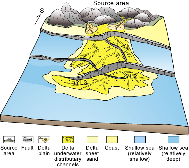
In summary, the large delta development model based on small source areas with multi-stage uplifting in the step fault zone (Fig. 10 ) points out that the episodic uplifting caused by the transition of the regional stress field provided sufficient sediments; the fluvial system formed by local compression and valleys together with watershed area controlled the scale of the sand bodies; the multi- step active faults and inner concave fault embayment dominated the transport channels of the sand bodies; and the fault troughs which were obliquely distributed controlled the lateral advance of the sand bodies.
Fig. 10. Multi-step fault-controlled delta sedimentary model of Ling 3 Member in YL10 area. |
6. Petroleum geological significance
The discovery of the Ling 3 Member large-scale delta reservoir in the southern step fault zone of the Baodao Sag and the construction of the sedimentary model have not only guided the exploration of oil and gas in the YL10 area, but also provided references for the study of oil and gas reservoirs in similar structural background.
The large-scale delta developed in the Ling 3 Member at the southern step fault zone of the Baodao Sag is located above multiple step faults. A series of active forward step faults not only provided favorable topographical and geomorphic conditions for the long-distance transport of abundant clastic materials to the center of the Baodao Sag, but also laid the foundation for various types of traps. Near the sedimentation-controlling faults, and influenced by continuous fault activities, sand bodies are not only very thick and vertically superimposed, but also have the potential to evolve into fault nose or fault block traps by docking with early mudstone. At the front end of the fan body, the sand bodies advanced along the fault troughs and laterally pinched out, creating favorable lithological traps. Additionally, controlled by a series of source-faults in the step fault zone, these traps also have good conditions for oil and gas migration. Drilling results indicate that preservation conditions are key factors for reservoir formation. Structural-lithological traps located on the flanks of sand bodies and fault nose traps with controlling faults stopped activity earlier are favorable traps for reservoir formation. For example, in Well YL3 drilled into the structural-lithological trap on the front flank of the Ling 3 Member delta in the study area, two sets of sand bodies were revealed, mainly composed of fine sandstone with 74.3 m thick in total. Gas layers of 25.74 m were interpreted, and no water was observed. In Well YL2 drilled into the fault nose trap controlled by F1, four sets of sand bodies were found vertically. They are mainly fine sandstone with a cumulative thickness of 138.5 m, and interpreted gas layer of 51.9 m. Due to the influence of fault leakage, the trap is not fully filled, and water is visible at the bottom of several gas layers. In Well YL1 drilled into the fault block trap controlled by multiple faults such as F1 and F2, sandstone layers of 109 m in thickness were found, but due to the influence of multiple faults, especially the late northwest trending active faults, all reservoirs are water layers.
The discovery of the large-scale delta reservoir in the Ling 3 Member and the construction of its development model in the southern step fault zone of the Baodao Sag have considerable geological significance. This discovery breaks the conventional understanding that small source areas cannot help develop large-scale reservoirs, points out the conditions required for the formation of large- scale reservoirs in small source areas and establishes a method for identifying and characterizing such reservoirs. This model can serve as a reference for the study of oil and gas reservoirs in other similar structural areas in the Qiongdongnan Basin. For example, in the southern slope of the Changchang Sag in the eastern part of the study area, there are small source areas, the late structural uplifts are high, and the upper Yancheng Formation has been clearly eroded. Analysis suggests that around the source areas, the Ling 3 Member exhibits strong-amplitude reflections on seismic profiles, and the progradation features toward the center of the sag are evident. Based on the sedimentary model established in this study, it is believed that similar favorable reservoir conditions exist, and preliminary identification of several favorable traps has been made, providing valuable guidance for future exploration in the southern slope of the Changchang Sag.
7. Conclusions
The YL10 denudation area in the southern step fault zone of the Baodao Sag has two northward fluvial systems (east and west) during the sedimentary period of the Oligocene Ling 3 Member, in two dominant sand transport channels and two delta lobes Sag, which are large in the west and small in the east. Vertically, the delta has experienced four stages: initiation, prosperity, intermittent and rejuvenation. Laterally, it experienced gradually eastward migration.
The volume of the delta sand bodies in the Ling 3 Member is approximately 194.43×10⁸ m3, and the average erosion thickness in the denudation area is about 146 m. Combined with the restoration of erosion amount, it is pointed out that the erosion in the source area can fully meet the predicted demand for sediment supply to the deltaic sand bodies. This confirms the material basis for the formation of large-scale reservoirs in the southern step fault zone.
Drilling data reveal that the delta of the Ling 3 Member is dominated by fine sandstone, totally 109-138 m thick, and the maximum thickness of single layer up to 15.5- 30.0 m. The sand-to-strata ratio is 43.7% to 73.0%, but the reservoir physical properties are obviously different among different step faults. The grain size Characteristics indicates hydrodynamic condition is dominated by traction currents. The logging data show that the delta as a whole exhibits inverse cycle, and the lower part is dominated by shallow marine and pro-delta deposits, while the upper part is characterized by delta front deposits.
The large delta development model of the small source area with multi-stage uplift in the step fault zone is established, and points out that episodic uplifting resulted from the transition of the regional stress field provides sufficient source supply. The fluvial systems formed by local compression and valleys, together with watershed area control the scale of the sand bodies. The multi-step active faults and inner concave fault embayment dominate the transport channels of the sand bodies. The fault troughs which are obliquely distributed control the lateral advance of the sand bodies.
The discovery of the large-scale delta reservoir in the Ling 3 Member and the construction of its development model break the conventional understanding that small source areas cannot help develop large-scale reservoirs. This study points out the conditions required for the formation of large-scale reservoirs in small source areas, and establishes a method for identifying and characterizing such reservoirs and can serve as a reference for the study on oil and gas reservoirs in other similar structural areas.
Nomenclature
Ai, bi—the areas of underwater distributary channels and sheet sand for each set of sand body, respectively, m2;
C—particle size corresponding to 1% cumulative mass fraction, μm;
f1, f2—sand formation coefficients of granite and sedimentary rocks, respectively, where the sand formation coefficient refers to the ratio of the volume of sandy debris formed by weathering and transport of the parent rock to the volume of the parent rock, dimensionless;
H—average erosion thickness in the denudation area, m;
Hi, hi—flattened thickness in the underwater distributary channel zone and the sheet sand zone of each set of sand body, respectively, m;
i—number of sand bodies, and the maximum value is 4;
M—median particle size, μm;
S1, S2—areas of granite parent rock and sedimentary parent rock, respectively, m2;
V—volume of sand bodies in the sedimentary zone, m3;
ϕ—unit of particle size commonly used in particle size analysis, dimensionless.