

Introduction
Since the 20th century, international oil companies have started their oil and gas exploration activities successively in Africa. Especially in traditional major oil producing countries (e.g. Egypt, Libya and Algeria in North Africa, and Nigeria in West Africa), the oil and gas exploration and development have progressed over 100 years. The oil and gas discoveries in these countries are mainly distributed in the cratonic basins in North Africa and passive continental margin basins in the Gulf of Guinea in West Africa. These basins are rich in oil and gas resources, with relatively simple tectonic styles and hydrocarbon accumulation models [1-2], making them the pioneers with commercial discoveries. In contrast, the intracontinental rift basins are influenced by large strike-slip shear zones, with complex structures, diverse origins of source rocks, a wide range of target strata, and various hydrocarbon accumulation models. Hence, during the 1970s to 1990s, western oil companies have made commercial discoveries only in the Doba Basin of Chad, and scarcely in other basins in the Central and West African Rift System (CWARS). The main reasons for not getting many discoveries in the basins in the CWARS by western oil companies include: (1) solely drilling uplifts in depressions; (2) neglecting the evaluation of source rocks and the selection of optimal oil-rich sags; and (3) not caring the role of strike-slip shear zones and the differences of basins in hydrocarbon accumulation conditions and characteristics.
China National Petroleum Corporation (CNPC) accessed to Block 6 of the Muglad Basin, Sudan, in 1995, marking the prelude of oil and gas exploration in the CWARS led by Chinese oil companies. In the past 30 years, CNPC initiated oil and gas exploration in basins, such as Muglad, Melut, Bongor, Doba, Doseo, and Termit, alone or in alliance with other partners. Through in-depth researches and application of effective exploration techniques, CNPC has achieved efficient exploration and beneficial development in these basins of the CWARS. Eleven oil fields with OIIP (oil initially in place) scale of one hundred million tons have been discovered, with cumulative OIIP more than 35×108 t. CNPC has witnessed the peak annual production capacity of 15×106 t in Block 1/2/4 of the Muglad Basin in Sudan/South Sudan, and 15×106 t in Block 3/7 of the Melut Basin in South Sudan, and has built the capacity of 6×10⁶ t in the Bongor Basin, and 3×10⁶ t in Block 6 of the Muglad Basin in Sudan. Furthermore, CNPC will realize a production capacity of 6×10⁶ t in Block A of the Termit Basin, and a quantity of OIIP with one hundred million-ton scale in Block D of the Doseo Basin. With the efforts of CNPC, most structural traps in the basins of the CWARS have been highly explored. It is necessary to investigate and clarify the petroleum geological characteristics and hydrocarbon accumulation models/differences of oil-rich sags in each basin, thereby supporting the definition of future exploration directions.
Based on the geological, seismic, and testing data from basins of the CWARS, this paper discusses the petroleum geology of oil-rich sags and identifies the similarities and differences in hydrocarbon accumulation in typical basins. The results are of great significance for further understanding the characteristics of hydrocarbon accumulation in the basins of CWARS, clarifying future exploration directions, and promoting additional large-scale discoveries in these basins.
1 Geological overview
Rift basins are favorable places for hydrocarbon accumulation [3-4]. There are numerous rift basins in the CWARS, which are hotspots for onshore oil and gas exploration in Africa. The CWARS is located in the central part of the African continent and consists of a group of Mesozoic-Cenozoic rift basins developed on the crystalline basement of the Precambrian and distributed within and along the sides of the Central and West African large strike-slip shear zones. These rift basins, different from the shear zones in tectonic locations and strikes, have distinct tectonic evolution processes and sedimentary filling characteristics. Some basins have experienced extensive transgression and developed marine source rocks, such as the Termit Basin, while other basins have not undergone transgression but developed lacustrine source rocks, such as the Melut, Muglad, and Doseo Basin. Some basins feature the superimposition of multiple rifting stages including the Early Cretaceous, Late Cretaceous, and Paleogene, such as the Melut Basin and Muglad Basin, while other basins are single-rift basins with the only record of Early Cretaceous rifting process, such as the Bongor Basin. Overall, the basins of the CWARS have characteristics of wide distribution, diverse source rock genesis [5-6], large series of target strata [7], and complex hydrocarbon accumulation models [8⇓⇓-11].
1.1 Basement of CWARS
The African continent was formed by the assembly of multiple stable landmasses during the Pan African movement, and the positions of these landmasses served as pre-existing structures to control the formation and evolution of the basins in the CWARS since the Late Mesozoic era [12⇓-14] (Fig. 1 ). The basement of the basins in the CWARS is Precambrian crystalline bedrock. From the Cambrian to the Jurassic, the Central African region was in a stage of stable platform development, with weak fault activity and extensive exposure of bedrock. Under arid climate conditions [15-16], physical weathering occurred, forming a large area of planation surface. Outcrop observations show that the surface of the bedrock develops a weathered layer composed of spherical weathered rocks of varying sizes, with a thickness of 10-50 m, covering the massive crystalline bedrock and forming a clear double- layer structure [17-18]. The weathered layer becomes an important reservoir for the basement buried hill reservoirs in the CWARS, represented by the Bongor Basin in Chad.

1.2 Tectonic evolution and sedimentary filling
Since the Late Mesozoic, the dextral strike-slip movement of the Central African strike-slip Shear Zone has influenced and controlled the formation and evolution of rift basins in the CWARS. These basins have obvious strike-slip-extensional characteristics, and have undergone three rifting stages in this region: Early Cretaceous, Late Cretaceous and Paleogene [7⇓⇓⇓-11,13,19]. The development and evolution of these basins are controlled by basement faults and influenced by the movement of the three landmasses within the African Plate and the peripheral European and Arab Plates (Fig. 1 ), resulting in different tectonic evolution processes and sedimentary filling characteristics in the basins [15,19,22]. According to the differences in regional tectonic location and evolution, the rift basins of the CWARS can be divided into three groups: (1) eastern CARS rift basins, which are mainly located on the eastern side of the Central African Rift System (CARS), including the Muglad, Melut and Anza basins in Sudan, South Sudan, and Kenya; (2) western basin group in CARS, including Bongor, Doba, Doseo and Salamat (Fig. 2 ); and (3) WARS (West African Rift System) rift basins, mainly including the Termit, Tenere and other basins within Chad and Niger (Fig. 2 ).
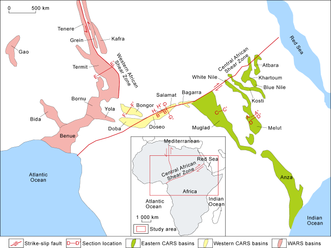
Fig. 2 Distribution of Central African Shear Zone, Central African and West African rift systems (modified from Reference [23]). |
The three groups of rift basins have different tectonic evolution processes and sedimentary filling characteristics. The western CARS rift basins deposited thick lacustrine source rocks and sandstone-mudstone interbeds during the Early Cretaceous. Affected by the Santonian compression event in the Late Cretaceous [8,13,22 -23], a strong tectonic reversal occurred, eroding the Upper Cretaceous strata to a varying extent. Since the Paleogene, they entered the sagging period and formed sedimentary layers rich in sandstones. The eastern CARS rift basins are characterized by the superimposition of three rifting stages. During the Early Cretaceous, the rifting activity was intense, and the main source rocks of lacustrine facies were deposited. During the Late Cretaceous, weak rifting activity was predominant, and a large set of interbedded sandstones and mudstones were deposited. During the Paleogene, the rifting process was once again intensified, and a set of coarse-fine-coarse continental clastic rocks developed, becoming the main hydrocarbon accumulation play of basins such as the Melut Basin[9]. The WARS rift basins experienced weak rifting process during the Early Cretaceous, and mainly developed coarse clastic deposits. During the Late Cretaceous, due to the local subsidence of the Northwest African landmass [19], large-scale transgression occurred, forming terrigenous organic matter-rich marine source rocks [6]. During the Paleogene, along with the continuous NE strike-slipping of the African Plate[22-23], they once again entered into the stage of rift evolution, forming massive lacustrine mudstones and sandstone-mudstone interbeds, which become the main play of Termit and other rift basins in the WARS.
1.3 Geothermal evolution
The formation of the CWARS is related to the strike-slip effect of the Central and West African Shear Zones. Early rifts in the basins were mainly induced by deep-large fault movements, without significant magmatic activity. Their geothermal gradients are low, and they are either "cool start" rifts [24] or passive rifts [25-26]. During the Late Cretaceous, magmatic activity began to occur in the Central African Shear Zone and its vicinity. The Santonian compression caused a 15° counterclockwise rotation in the Benue Graben, Doba Basin, and Bongor Basin [24]. Magmatic activity became frequent. However, volcanic activity was weak in the Melut Basin, central-south Muglad Basin, and the Termit Basin, which were far away from the Central African Shear Zone. During the Paleogene, volcanic activity in the Central African Shear Zone and its vicinity became more frequent and widespread. A volcanic belt of 1 600 km long was formed in Cameroon, and several large Cenozoic volcanic centers were also developed in the Central African region. The Bouguer gravity anomaly section in the Muglad Basin [27] shows that negative gravity anomalies were developed under the regional setting of positive Bouguer gravity anomaly due to crustal thinning and mantle uplifting. The latest high-resolution 3D seismic data from the northern part of Kaikang reveals that the boundary faults of the Muglad Basin in the Neogene have listric characteristics, and the basin as a whole has a "bull-headed" structure [19]. The above characteristics indicate that the rise of the asthenosphere is the main cause of the Paleogene rift process. In addition, research on the thermal evolution history of the Termit Basin in the WARS reveals that the thermal flow value of the basin was the lowest during the Early Cretaceous rifting period, gradually increased from the Late Cretaceous to the Paleogene, and peaked at the end of the Paleogene rifting period [28]. Therefore, the CWARS had high geothermal gradient and active rift characteristics during the Paleogene rifting period [29-30]. Under the warming effect during the Late Paleogene, the source rocks of the Cretaceous in various basins of the CWARS entered mature and highly mature evolution stage on a large scale, and hydrocarbons accumulated in reservoirs in multiple sets of strata from the basement to the Paleogene [7⇓⇓-10,26,28,31].
2 Main petroleum geological characteristics of oil-rich sags in CWARS
In the basins of the CWARS, the exploration focuses on conventional oil and gas reservoirs, while unconventional resources such as shale oil are still in the evaluation stage. This paper deals with the petroleum geological characteristics related to conventional oil and gas accumulation. Due to different tectonic evolution processes and sedimentary filling characteristics, the basins are distinct in source rocks, reservoir-cap rock assemblages, and hydrocarbon accumulation models. In-depth research on petroleum geological characteristics of oil-rich sags in the basins to clarify the control factors and models of hydrocarbon accumulation and the hydrocarbon enrichment rules is of great significance for updating the exploration deployment to fix new targets and ultimately making additional discoveries in these basins.
2.1 Two types of high-quality source rocks provide the material basis for oil and gas enrichment
Oil-rich sag is a term used to describe the resource richness of hydrocarbon generating sags in a petroliferous basin, originated from research on rift basins in eastern China. Essentially, it emphasizes the quality, scale, thermal evolution degree, and total amount of hydrocarbon generation and expulsion of source rocks in the sag. This concept points out the imbalanced spatial distribution of resources [32]. Numerous exploration practices have confirmed that only oil-rich sags have the resource foundation to form large- and medium-sized oil and gas fields [33-34]. In the early access to the basins of the CWARS, CNPC used various methods to evaluate the source rocks and quickly identified a number of oil-rich sags. The resource abundances of these sags exceed the standard of oil-rich sags (20×104 t/km2) proposed by Yuan et al. [35] in their study of resource distribution in the Bohai Bay Basin of China. For instance, the resource abundance is 66×104 t/km2 in the Fula Sag in the Muglad Basin, 72.5×10⁴ t/km2 in the North Sag in the Melut Basin [36], and 100×104 t/km2 in the Baobab North Sag in the Bongor Basin (Table 1 ). Further evaluation of source rocks, selection of optimal oil-rich sags, and exploration deployment for oil-rich sags are crucial to efficient exploration in the basins of the CWARS.
Table 1 Source rock indicators [5] and resource abundance of the oil-rich sags in the main basins of CWARS |
| Age | Basin | Strata | TOC/% | Organic type | Maturity | Total thickness/m | Oil-rich sag | Resource abundance/ (104 t•km-2) |
|---|---|---|---|---|---|---|---|---|
| K2 | Termit | Yogou Fm. | 0.36-23.32/2.60 | II1-III | Mature-high mature | >1 000 | Dinga Sag | 32.0 |
| K1 | Bongor | M Fm. | 0.26-14.00/1.78 | I-II | Low mature-high mature | >500 | Baobab North Sag | 100.0 |
| P Fm. | 0.28-16.80/1.98 | |||||||
| Muglad | AG Fm. | 1.00-3.70 | I-II1 | Mature-high mature | >460 | Fula Sag | 66.0 | |
| Melut | Al Renk Fm. | 0.10-7.95/1.32 | I-II | Low mature-mature | >800 | North Sag | 72.5 | |
| Doseo | Kedeni Fm. | 0.44-10.10/3.69 | I-II1 | Mature-high mature | >500 | East Sag | 52.0 |
Note: The value after “/” is average. |
Oil-rich sags exist in all main basins of the CWARS, but they are different in genesis of source rocks. The CARS was formed in the tectonic activity zone between the Northeast African Landmass and Central-South African Landmass (Fig. 1 ). During the Early Cretaceous, strong tectonic activity, high subsidence rate of the lake basin, and widespread dark mudstones in semi-deep to deep lake promoted the development of high-quality lacustrine source rocks. Typically, the subsidence rates of lake basins during the development of source rocks in the M-P Formations of the Bongor Basin and the AG Formation of the Muglad Basin range from 100 to 300 m/Ma, the average basin tension rate during the sedimentation of the Al Renk Formation in the Melut Basin is 6.4%, and the average tension rate during the sedimentation of the source rocks in the AG Formation in the Muglad Basin is 14% [5]. These indicators are all higher than the reference values proposed by Jiang et al. [37] for the subsidence rate (100 m/Ma) and the tension rate (4%) of high-quality source rocks. Drilling results reveal that the main source rocks, including the M-P Formations in the Bongor Basin, the AG Formation in the Muglad Basin, the Al Renk Formation in the Melut Basin, and the Kedeni Formation in the Doseo Basin, are all developed in the Lower Cretaceous, with organic matter of Types I-II (Fig. 3 ), the average TOC of 2% (maximum up to 16.8%), and the cumulative thickness of hundreds of meters to several kilometers; they are in the stage of low to high maturity (Table 1 ). The high-quality, thick and mature lacustrine source rocks provide a material basis for the formation of oil-rich sags in the CARS.
The WARS, in the tectonic activity zone between the Northwest African Landmass and Northeast African Landmass (Fig. 1 ), has different tectonic evolution processes and source rock characteristics from the CARS. In the Early Cretaceous, the rifting process was weak, coarse clastic sediments were dominant, and no effective source rocks were developed [11,38]. In the Late Cretaceous, influenced by local subsidence of the Northwest African Landmass, it suffered from bidirectional transgression from the Tethys and South Atlantic [25]. Coupling with the strike-slip extension, marine strata with thickness of 900-3 000 m were deposited in basins such as Benue, Termit, Terene, and Grein [24,39], forming the Upper Cretaceous terrigenous organic matter-rich marine source rocks. Among them, the Benue Basin experienced strong compression and uplift in the later stage, with only a small amount of residual Upper Cretaceous marine strata in local areas [40], while the Termit Basin has well-preserved Upper Cretaceous marine strata, including the transgressive mudstone in the Donga Formation and the regressional sandstone-mudstone in the Yogou Formation. Geochemical analysis of source rocks shows that the average TOC value is 2.6% (maximum up to 23.32%), and the organic matters are Types II1-III (Fig. 3 ) [28], suggesting that the source rocks are in the mature to high mature stage (Table 1 ). The thick terrigenous organic matter-rich marine source rocks widely distributed in the Upper Cretaceous provide a material basis for the development of oil-rich sags in the WARS, and contributed oil sources to the oil-rich zones with OIIP scale of 1×10⁸ t, such as the Dibeilla structural belt and Trakes slope in the eastern part, the Fana low bulge in the central part, and the Yogou slope in the western part of the Termit Basin [41].
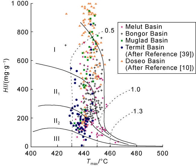
Fig. 3 Relationship between Tmax and HI in the basins of CWARS. |
2.2 Three sets of regional cap rocks are crucial to large-scale hydrocarbon accumulation
Cap rocks play a crucial role in hydrocarbon accumulation [42-43], and the quality and distribution of cap rocks determine the degree and spatial coverage of hydrocarbon enrichment in the basin. The oil-rich sags in the major basins of the CWARS all develop regional cap rocks, such as the Paleogene Adar Formation in the North Sag of the Melut Basin (Fig. 4 ), the Lower Cretaceous Doba Formation in the East Sag of the Doseo Basin, and the Paleogene Sokor2 Formation in the Dinga Sag of the Termit Basin. Overall, the basins in the CWARS develop three sets of regional cap rocks: Lower Cretaceous, Upper Cretaceous, and Paleogene. However, due to different formation mechanisms and tectonic evolution processes of the basins, the developed layers and sets of regional cap rocks are different. Studying the formation mechanisms, development layers, and reservoir control characteristics of cap rocks in the basins is of great significance for determining the plays and clarifying the exploration layers of the basins in the CWARS.
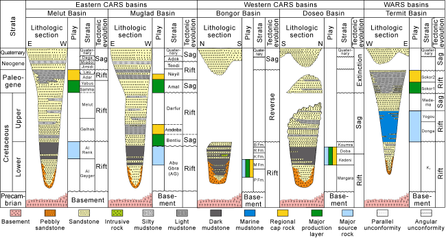
Fig. 4 Comparison of tectonic evolution, sedimentary filling, and plays in the basins of CWARS (modified from Reference [7]). |
The development of regional cap rocks in the CWARS is controlled by the tectonic evolution process of each basin and closely related to the basin trends. The NW-SE trending basins feature the superimposition of multiple rifting stages, including the Late Cretaceous and Paleogene, in addition to the Early Cretaceous, with mudstones of different thicknesses, forming regional cap rocks in the Upper Cretaceous and Paleogene (Fig. 4 ). In the Muglad Basin, the Aradeiba Formation mudstones with a thickness of 180-500 m deposited in the early rifting stage of the Late Cretaceous seal the oil and gas generated by the source rocks in the AG Formation of the Lower Cretaceous, and control 70% of the discovered reserves [26,43], serving as the main regional cap rocks in the basin. In the Melut Basin, weak rift activity occurred during the Late Cretaceous, mainly forming sandstone-mudstone interbeds in the Galhak Formation and massive sandstone-rich strata in the Melut Formation, without thick mudstone layer; the regional cap rocks were mainly formed during the Paleogene rifting period. Affected by the accelerated movement of the African-Arabian Plates in the northeast direction during the Paleogene [22-23], the extension of the NW-SE trending basins was further strengthened, and strong rifting activity occurred in basins such as Melut, Termit, and Muglad. Typically, in the Melut Basin, the Adar Formation mudstones were deposited as regional cap rocks during the Eocene rifting period (Fig. 5 ), which control over 90% of the discovered reserves [44]; in the Termit Basin, the Sokor2 lacustrine mudstones were deposited as regional cap rocks during the Oligocene rifting period, which control over 90% of oil and gas discoveries together with the underlying sandstone reservoir in the Paleocene-Eocene Sokor1 Formation (Fig. 4 ) [45]. The Muglad Basin also deposited thick mudstones in the Nayil Formation during the Eocene to Oligocene periods (Fig. 4 ), forming a Paleogene reservoir-cap rock assemblage with the underlying sandstone reservoir in the Paleogene Amal Formation. Oil and gas have been discovered in some areas of the basin.
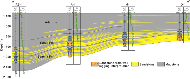
Fig. 5 Lithological section of regional cap rocks of Paleogene Adar Formation and underlying strata in North Sag of Melut Basin (the section location is shown in |
In the NE-SW trending basins, due to the Santonian compression event in the Late Cretaceous, tectonic inversion and regional thermal subsidence occurred during the Late Cretaceous and Paleogene, without thick mudstones or with strata hiatus. Therefore, the NE-SW trending basins mainly form regional cap rocks within the Lower Cretaceous source rocks, such as the M and P Formations in the Bongor Basin and the Doba and Kedeni Formations in the Doseo Basin, which are both source rocks and cap rocks [8,10] (Fig. 6 ). Clearly, the basins of the CWARS develop multiple sets of thick mudstones from the Lower Cretaceous to the Paleogene. However, each basin only has a set of regional cap rock closely related to hydrocarbon accumulation. Moreover, due to the influence of tectonic evolution, the development intervals of the regional cap rocks vary from basin to basin. The development of regional cap rocks is the key to the large-scale hydrocarbon accumulation in the basins of the CWARS.
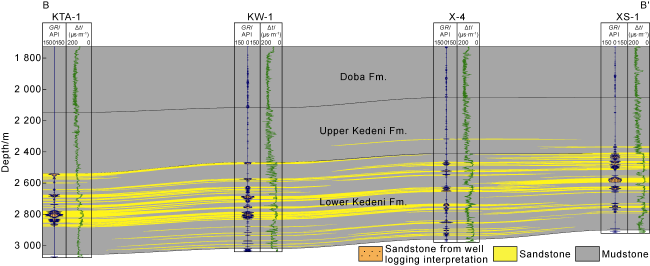
Fig. 6 Lithological section of Lower Cretaceous Doba and Kedeni formations in East Sag of Doseo Basin (the section location is shown in |
2.3 Differential configuration of source rocks, reservoir rocks and cap rocks contributes complex and diverse hydrocarbon accumulation models
The different basin formation mechanisms and tectonic evolution processes lead to the development of two types of source rocks in the basins of the CWARS: the Lower Cretaceous lacustrine mudstone and the Upper Cretaceous marine mudstone, three sets of regional cap rocks (Lower Cretaceous, Upper Cretaceous, and Paleogene), and multiple sets of reservoir rocks (bedrock, Lower Cretaceous, Upper Cretaceous, and Paleogene) (Fig. 4 ). This differential configuration of source rocks, cap rocks, and reservoir rocks endows the basins of the CWARS with complex and diverse hydrocarbon accumulation models and enrichment characteristics. By dissecting the hydrocarbon accumulation conditions, enrichment characteristics, and typical reservoirs in the basins of the CWARS, three types of hydrocarbon accumulation models were established: down-source and up-reservoir, and hydrocarbon accumulation above source rocks; source and reservoir in the same formation, and hydrocarbon accumulation inside source rocks; and up-source and down-reservoir, and hydrocarbon accumulation below source rocks. The main hydrocarbon accumulation models in each basin are closely related to the basin trend. Basins with the same trend have similar hydrocarbon accumulation models, while basins with different trends are distinct in hydrocarbon accumulation models.
The NW-SE trending basins have the characteristics of multiple rifting stages superimposed, and mainly develop the hydrocarbon accumulation model of down-source and up-reservoir, and hydrocarbon accumulation above source rocks, which can be subdivided into two subtypes: near and above source rocks, and far and above source rocks, according to the distance between the reservoir-cap rock assemblage and the source rock. In the Muglad Basin, the Upper Cretaceous Aradeiba Formation regional cap rocks and the underlying Bentiu Formation reservoir rocks are close to the Lower Cretaceous AG Formation source rocks and form a hydrocarbon accumulation model of near and above source rocks (Fig. 7a ), which controls 70% of reserves discovered in the basin [43]. In the Melut Basin, the Eocene Adar Formation regional cap rocks, the underlying Paleocene Yabus and Samma Formation reservoir rocks, and the Lower Cretaceous Al Renk Formation source rocks form a hydrocarbon accumulation model of far and above source rocks (Fig. 7b ), which controls over 90% of oil and gas discoveries in the basin [44]. In the Termit Basin, the Oligocene Sokor2 Formation regional cap rocks, the underlying Paleocene-Eocene Sokor1 Formation fluvial-delta sandstone reservoirs, and the Upper Cretaceous lower Yogou Formation source rocks form a hydrocarbon accumulation model of far and above source rocks (Fig. 7c ), which controls over 90% of oil and gas discoveries in the basin [45].
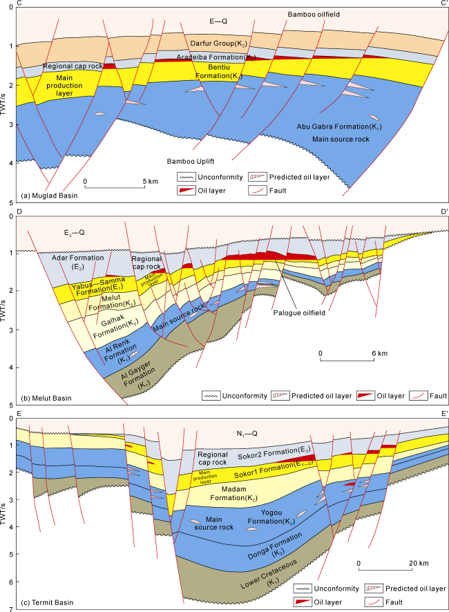
Fig. 7 Hydrocarbon accumulation model with “down-source and up-reservoir, and hydrocarbon accumulation above source rocks” in NW-SE trending basins of CWARS (the section locations are shown in |
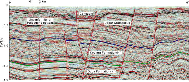
Different from the NW-SE trending basins with the superimposition of multiple rifting stages, only one stage of rifting in the Early Cretaceous was preserved in NE-SW trending basins, forming two hydrocarbon accumulation models: source and reservoir in the same formation, and hydrocarbon accumulation inside source rocks; and up-source and down-reservoir, and hydrocarbon accumulation below source rocks. In the Bongor Basin, a strongly reversed basin, affected by the Santonian compression event [8,13,22 -23], the Upper Cretaceous strata are completely absent, and the Cenozoic is relatively thin. The main present residual sediments were deposited during the Early Cretaceous rifting, forming a model of hydrocarbon accumulation inside source rocks which consists of the M Formation and P Formation source rocks and their internal sandstone reservoirs, controlling 63% of the discovered reserves in the basin [46] (Fig. 8a ). In addition, the basement of the Bongor Basin is composed of Precambrian crystalline bedrock, which was weathered and eroded for a long time from the Cambrian to the Jurassic. A weathered layer with a thickness of 10-50 m was formed on the surface of the bedrock, and it constitutes a model of hydrocarbon accumulation in buried hill below the source rock with the overlying P Formation mudstones (Fig. 8a ). Thus, this can be considered as an important exploration target. In the Doseo Basin, there is no play in the Upper Cretaceous and Cenozoic, but an inside-source play in the Lower Cretaceous Kedeni Formation (Fig. 8b ). The Upper Cretaceous in the basin also suffered from uplift and erosion, with a residual sandstone-rich layer of approximately 500 m thick. The Paleogene-Neogene was a stage of thermal subsidence, when sandstones were mainly deposited. Moreover, due to the collision between the African and European Plates (Alpine Orogeny), the basin was reversed and uplifted, leading to strata erosion. The present-day Cenozoic strata are thinner than 500 m (Fig. 9 ), in contrast to the 3000 m thick Cenozoic strata in the NW-SE trending basins (e.g. Termit, Muglad, and Melut) [8,21]. As the Mangara Formation, which was deposited in the early stage of the Cretaceous rifting, is a large set of sandstone-rich strata, and the bedrock buried hills do not have cap rock conditions, the Doseo Basin does not develop a buried hill play below source rock.
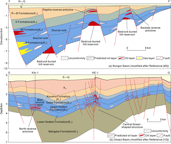
Fig. 8 Hydrocarbon accumulation model with “up-source and down-reservoir, and hydrocarbon accumulation below source rocks” and “source and reservoir in the same formation, and hydrocarbon accumulation inside source rocks” in NE-SW trending basins of CWARS (the section locations are shown in |
Fig. 9 Thickness of Cenozoic and unconformity reflection characteristics of Paleogene bottom in Doseo Basin (the section location is shown in |
2.4 Diverse traps make large-scale hydrocarbon accumulation possible
Traps are places where oil and gas accumulate, and they consist of reservoir, cap rock, and lateral barrier. According to genesis, traps can be divided into structural trap, lithological-stratigraphic trap, and composite trap. Under the multiple effects of early rifting, late compression, and regional strike-slipping of the Central African Shear Zone, various structural traps (e.g. reverse anticline, flower-shaped structure, draping anticline, and antithetic fault block), as well as lithological-stratigraphic traps and composite traps (e.g. bedrock buried hill, sandstone lens, and fault-lithology traps) are developed in the CWARS. These traps allow large-scale hydrocarbon accumulation in the basins. Currently, structural traps in the basins of the CWARS are the main explored targets. A number of large- and medium-sized oil and gas fields have been discovered through 2D and 3D seismic surveys and centralized exploration. Nonstructural traps such as sandstone lens and fault-lithology traps will be important targets for future exploration.
The basins in the CWARS are different in trap characteristics, attributable to different structural evolution and sedimentary filling. The NE-SW trending basins have gone through the tectonic evolution process of Early Cretaceous rifting, Late Cretaceous inversing, and Cenozoic depressing. The main present residual sediments were deposited during the Early Cretaceous rifting process. Two hydrocarbon accumulation models are recognized in these basins, that is, "hydrocarbon accumulation inside source rocks" in the Lower Cretaceous source rocks, and "hydrocarbon accumulation below source rocks" in the Lower Cretaceous source rocks and underlying bedrock buried hills. Due to the dual influence of the Late Cretaceous Santonian compression and the regional strike- slipping of the Central African Shear Zone, the western CARS basins with NE-SW trend generally develop reverse anticlines and flower-shaped structures. For instance, the North slope of the Bongor Basin develops reverse anticline structures (e.g. Raphia and Baobab) (Fig. 8a ), while the north steep slope and central structural belt of the Doseo Basin also develop many reverse anticlines and flower-shaped structures (Fig. 8b ). Various compressional and strike-slip structures related to reverse anticlines and flower-shaped structures, such as anticline, faulted anticline, fault block, are the main trap types in NE-SW trending basins. In addition, the bedrock buried hill trap is a favorable type in the Bongor Basin with strong reversion [8].
The NW-SE trending basins feature the superimposition of multi-stage rifts, including the Late Cretaceous and Paleogene, in addition to the Early Cretaceous. These basins have well-developed extensional structures. Especially during the Paleogene, the strike-slip extension was further enhanced along with the accelerated movement of the African-Arabian Plates in a northeast direction[22-23], further complicating the Cretaceous graben and resulting in a large number of faults, forming many fault block traps. The exploration shows that paleouplift-related extensional structures (e.g. draping anticline, faulted anticline, and antithetic fault block) are the main trap types in NW-SE trending basins. For example, the Bamboo oilfield in the Muglad Basin is a reverse fault block oil reservoir developed on the Bamboo uplift (Fig. 7a ) [47], the Palogue oilfield with a scale of 1×10⁸ t OIIP is developed in a draping anticline on the paleouplift in the northern part of the Melut Basin (Fig. 7b ), and the Termit Basin develops a series of antithetic fault block with oil reservoirs on its eastern slope (Fig. 7c ).
In addition to structural traps, nonstructural traps (e.g. sandstone lens and fault-lithology traps) are commonly developed in the source rock layers of the basins in the CWARS during the rifting period. With the progress of exploration, these nonstructural traps will be important targets for future exploration in the CWARS.
3 Future exploration targets for basins in CWARS
Since access to Block 6 of the Muglad Basin in 1995, CNPC has devoted great efforts to the evaluation of source rocks and the selection of optimal oil-rich sags, and performed overall evaluation and deployment for oil-rich sags. So far, CNPC has achieved significant discoveries and efficient exploration in its licenses in Africa. With operations over 30 years, structural oil reservoirs in the main plays in the CWARS have been highly explored. There is an urgent need to explore new layers and domains for purpose of additional commercial discoveries in these basins. After studying the basin formation mechanism, tectonic evolution process, and hydrocarbon accumulation characteristics/models of these basins, it is concluded that new strata beyond major production layers, lithological reservoirs and shale oil are three important potential directions for the future exploration in the CWARS.
New strata will be explored mainly in the basins with the superimposition of multiple rifting stages and the model of hydrocarbon accumulation above source rocks. The exploration of rift basins such as Bongor and Doseo shows that in the basins of the CWARS where high-quality source rocks are commonly developed, the reservoir-cap rock assemblage with sandstone-mudstone interbeds inside the source rocks is worthy of exploration. In these basins such as Melut, Muglad, and Termit, early exploration activities focused on the plays above source rocks, but rarely involved the plays inside source rocks. Further efforts will be taken to the evaluation and exploration of the plays inside source rocks in these basins. In addition, the plays below source rocks formed by source rocks and underlying strata are also worth of attention [48]. In the Melut Basin, for example, some exploration wells have revealed oil and gas in the antithetic fault block traps formed by the source rock of the Lower Cretaceous Al Renk Formation and the underlying sandstone reservoir of the Al Gayger Formation.
Lithological oil reservoirs will be explored mainly in the basins (e.g. Bongor and Doseo) with the model of hydrocarbon accumulation inside source rocks, especially the sandstone lens and fault-lithologic traps. The early exploration in these basins mainly focused on the structural oil reservoirs inside the source rocks and the bedrock buried-hill oil reservoirs below the source rocks, but the lithological oil reservoirs have not yet been systematically treated. However, geological studies show that these basins have good conditions for forming lithological oil reservoirs. For instance, multiple fan deltas are developed in the source rock of the Kedeni Formation of the Lower Cretaceous in the north steep slope of the Doseo Basin. The fan deltas interact with source rocks, providing good conditions for source-reservoir-cap rock configuration. Moreover, multiple rows of reverse structures are developed in the north steep slope, which is conducive to the superposition of fan deltas and reverse structures to form various lithological and structural-lithological reservoirs.
Shale oil is an important strategic replacement in the CWARS. According to the evaluation of source rocks, there are two types of high-quality source rocks in the CWARS. These thick source rocks with high organic carbon abundance and moderate maturity indicate good potential for shale oil exploration. According to data from the Energy Information Agency (EIA) and Advanced Resources International Inc. (ARI) in 2013 [49], Chad is abundant in continental shale oil, with technically recoverable resources of 23.14×10⁸ t, ranking the 7th in the world. Specifically, in the Bongor Basin, the prospective area of Lower Cretaceous shale oil is 1.2×10⁴ km2, with estimated technically recoverable resources of 3.57×10⁸ t; in the Doseo Basin, the prospective area of Lower Cretaceous shale oil is 1.4×10⁴ km2, with estimated technically recoverable resources of 10.14×10⁸ t. Through years of theoretical and technical researches, China has initially formed the theory and technologies for exploration and development of continental shale oil [50-51]. Significant progress has been made in the industrial production of shale oil, and several national shale oil demonstration zones have been established, including Jimusar in Xinjiang Oilfield, Longdong in Changqing Oilfield, Gulong in Daqing Oilfield, and Jiyang in Shengli Oilfield. In 2022, China's shale oil production exceeded 300×104 t [52], doubling from 2018. The exploration theory of continental shale oil, as well as the engineering technology system for drilling and completing long horizontal wells and large-scale volume fracturing, are improving, and will provide theoretical and engineering technical conditions for expanding onshore shale oil projects in Africa. As to exploration in the CWARS, it is recommended to strengthen the evaluation of shale oil potential and the selection of high-quality blocks on the basis of existing risk exploration projects, so as to prepare for the exploration of pilot zones and construction of demonstration zones of onshore shale oil in Africa.
4 Conclusions
The basins in the CWARS are similar in regional background stress field and formation time, but different in trend and regional position, making them variable in petroleum geological conditions and hydrocarbon accumulation characteristics. Overall, the CARS develops high- quality lacustrine source rocks in the Lower Cretaceous, while WARS develops high-quality terrigenous marine source rocks in the Upper Cretaceous. These two types of high-quality source rocks provide a material basis for hydrocarbon enrichment in the CWARS.
The basins in the CWARS develop three sets of regional cap rocks (Lower Cretaceous, Upper Cretaceous, and Paleogene), as well as multiple sets of reservoir rocks from the bedrock to the Paleogene. The basins with different trends have different configurations of source-reservoir-caprock assemblages and hydrocarbon accumulation models. The NE-SW trending basins record only one stage of rifting in the Early Cretaceous, with regional cap rocks within the strata of the Lower Cretaceous rifting period. They are recognized with two types of hydrocarbon accumulation models: source and reservoir in the same formation, and hydrocarbon accumulation inside source rocks; and up-source and down-reservoir, and hydrocarbon accumulation below source rocks. Various compressional and strike-slip structures are the main tectonic styles and trap types in such basins. The NW-SE trending basins feature the superimposition of multiple rifting stages. They are characterized by two sets of regional cap rocks (Upper Cretaceous and Paleogene), and the hydrocarbon accumulation model with up-source and down-reservoir, and hydrocarbon accumulation above source rocks. The main tectonic styles and trap type in these basins are extensional structures (e.g. draping anticline, faulted anticline, and antithetic fault block).
In addition to structural traps, nonstructural traps such as sandstone lens and fault-lithology traps are also developed in the source intervals of the basins in the CWARS. With the increasing exploration level of structural traps, strengthening the exploration deployment in new domains is crucial to making additional discoveries in the basins. Future exploration in the CWARS should be focused on the inside-source formations in the Muglad, Termit, and other basins with multi-rifting superimposition, as well as inside-source lithological oil reservoirs and shale oil in the Bongor, Doseo, and other basins with single rifting stage.