

Introduction
The subsidence research is crucial to understand the evolution, material filling characteristics, mineralization and accumulation of mineral resources in a basin, which are closely related to the deep fluid activity and plate tectonic evolution of the Earth. A large amount of research and expatiation have been conducted on the subsidence center, depocenter and subsidence mechanism, explicating that the distribution and migration of subsidence centers is a comprehensive reflection and specific performance of regional tectonic dynamic, thermal regime, provenance characteristics, hydrodynamic conditions and so on in the evolution of a basin [1⇓⇓-4].
The Ordos Basin is rich in oil and gas resources, which is the largest oil and gas production base in China. It is located at the junction of the Paleo-Asian, Tethyan and the Circum-Pacific dynamic system domains. The interaction of these major dynamic system domains in different geological history stages causes the internal stability and peripheral activity of the basin. It also controls the mineralization, accumulation, occurrence, enrichment and distribution of energy minerals such as oil and natural gas [5⇓-7].
The Middle-Upper Triassic Yanchang Formation is a major oil-bearing stratum in the Ordos Basin. In the past, the research on the development and sedimentary characteristics of the 10th Member of the Yanchang Formation (Chang 10 Member for short) at the bottom is weak, due to relatively few exploratory wells drilled through the Yanchang Formation in the basin, especially in the central and southern regions where only about 20 wells drilled through the Yanchang Formation, and oil and gas shows in the lower strata of the Yanchang Formation are poor. Understanding about the Chang 10 Member of the basin is usually speculated by the information from limited geological outcrops around basin. The analysis of basin subsiding and filling process mainly focused on the sedimentary period of the 7th Member of Yanchang Formation (the following abbreviated as Chang 7 Member), or Yanchang Formation is treated as a unit, accordingly the research on the initial subsidence of the basin is insufficient [5,8⇓ -10]. Hence, the overall understanding of inland basin evolution is affected. In recent years, a large number of exploratory wells, targeting at the Paleozoic natural gas pools, have been drilled in the southern part of the basin, supplementing a large number of the deep stratigraphic data of the Yanchang Formation. Based on these deep well data, the subsidence and filling process of the basin during Mid-Late Triassic are systematically studied, through the analysis of strata thickness, lithology combination and sedimentary facies distribution of different intervals. Characteristics and mechanism of Ordos Basin-Qinling Mountains coupling evolution are further revealed. Through the above work, it is expected to provide more detailed information for an overall understanding on the Mesozoic basin formation, hydrocarbon generation and accumulation, and occurrence characteristics of oil and gas.
Since the Middle Triassic Zhifang Formation in the Ordos Basin is characterized by a thickness of 260-330 m, relatively stable deposition, a little change in lateral thickness, this paper focuses on the two periods of deposition in Yanchang Formation for studying Late Triassic settlement.
1. Geological setting
The Ordos Basin possesses a relatively regular morphology, surrounded by mountains and extending in a nearly rectangular shape in the north-south direction. To the north lies the Yinshan Mountains, to the south the Qinling Orogenic Belt, to the west the Helan and Liupanshan Mountains, and to the east the Lüliang Mountains, covering an area of 37×104 km2. Based on stratigraphic characteristics and the structural form of the basement topography, the main part of the Ordos Basin can be divided into six structural units, i.e. Western margin thrust belt, Tianhuan depression, Yishan slope, Jinxi fold belt, Weibei uplift, and Yimeng uplift (Fig. 1a ).
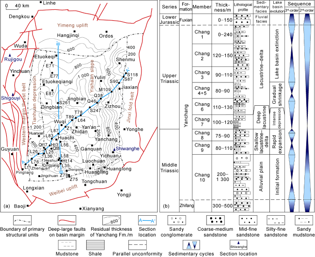
Fig. 1. Structural division (a) and comprehensive column (b) of Yanchang Formation in the Ordos Basin. |
The formation of the Yinshan folded mountain system in the northern part of the Ordos Basin is closely related to the evolution of the Paleo-Asian Ocean, whose closure age is early in the west and late in the east [11⇓-13]. The ocean-land conversion in the west was completed at the end of the Early Carboniferous, while in the east occurred from Permian to the Early Triassic. The contiguous Triassic was developed in the Lüliang Mountains, an area regarded as the eastern margin of the basin, indicating it had not yet risen to be a mountain and continuously received sediments at that time, and structural differentiation between Lüliang Mountains and the Ordos Basin has not occurred yet [14-15]. As to the North Qilian Mountains western to the Ordos Basin, the ancient Qilian ocean closure and plate collision occurred during the Late Ordovician-Devonian periods [16⇓⇓-19]. A large number of Triassic strata, having sedimentary characteristics and evolution similar to Triassic of the Ordos Basin [20⇓-22], are exposed in the Helan Mountains, which is regarded as the northwestern boundary of the present basin. Some researchers suggest that it was a part of the Great Ordos Basin, utile the uplift of Helan Mountains in the Late Jurassic under the action of NE-SW tectonic compression [23]. The above information illustrates that the present northern, western and eastern boundaries of the Ordos Basin were in a relatively stable tectonic environment in the Mid-Late Triassic.
The Qinling orogenic belt constitutes the southern boundary of the present Ordos Basin. The Qinling region experienced ocean-continent to continent-continent subduction and collision, followed by post-orogenic extensional collapse and volcanic activities during the Late Paleozoic to the Mid-Late Triassic. The forming of the Indosinian Mianlüe suture marks the completion of the main collage of Chinese continent [24-25]. The orogenic movement ended the Paleo-Tethys Ocean evolution in the Qinling Mountains and formed the paleogeographic distribution pattern of marine in the south and continent in the north of China. This tectonic movement also had significant influence for the formation and evolution of the southward Sichuan foreland basin and the northward large inland Ordos Basin [7,9 -10,26 -27]. The southern Ordos Basin was significantly affected by the regional tectonic dynamic of the Mianlüe Ocean northward subduction and Yangtze plate-North China plate collision.
2. Sedimentary strata of Yanchang Formation
2.1. Stratigraphy
The residual thickness of the Triassic in the hinterland of the Ordos Basin is between 1 200-2 500 m generally. The lower part is reddish sediments formed in hot and dry climate, while the Yanchang Formation in the upper is characterized by a lithology combination of gray-green medium-fine sandstone, fine sandstone, siltstone, and gray, gray-black, and black mudstone and shale, interbedded with multiple tuff laminae, which are sediments in river, delta, lake, and gravity flow under warm and humid climatic conditions. According to the sedimentary cycle, the Yanchang Formation can be divided into 10 members, from top to bottom is Chang 1 to Chang 10. The Chang 10 to Chang 8 Members belong to the Middle Triassic, while the Chang 7 to Chang 1 Members belong to the Upper Triassic (Fig. 1b ) [28-29].
The residual thickness of the Yanchang Formation ranges from 500 m to 1 700 m in basin, showing a distribution pattern of thinner in the north and thicker in the south. Especially in Huanxian-Zhenyuan-Qingyang- Zhengning areas in the southwest, the residual thickness ranges from 1 500 m to 1 700 m (Fig. 1a ). The residual thickness is influenced by multiple factors such as tectonic subsidence, unbalanced uplift and erosion caused by the Late Indosinian tectonic movement, and river erosion and downcutting in the Early Jurassic [30-31] (Fig. 2 ).
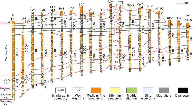
Fig. 2. Triassic stratigraphic comparison from northern Pingliang in Gansu Province to Shenmu in Shaanxi Province in Ordos Basin. Q—Quaternary; J—Jurassic; Ch1-Ch10—Chang 1-Chang 10 members; T2z—Zhifang Formation; T1h—Heshanggou Formation; T1l—Liujiagou Formation; P3s—Shiqianfeng Formation. The section position is shown in |
2.2. Sedimentary characteristics
The Ordos Basin was a large inland lake basin during the Mid-Late Triassic period, with ancient terrain feature showing high, broad and gentle in the northeast, while low and steep in the southwest. The depression axis or depocenter exhibited asymmetrical dustpan shape in NW-SE direction. The Yanchang Formation records a complete cycle of water transgression and regression. In the early and late stages, the sedimentation had the characteristics of shallow water, and rivers, deltas and shore-shallow lakes developed. In the middle stage, semi-deep lake and deep lake were widely distributed, and the gravity flow sand bodies were extended parallel to the sedimentary facies boundary, with superimposed sand bodies area more than 3×10⁴ km2. The maximum lake flooding happened in Chang 7 period, with a specific lithologic combination including mud shale and gravity flow sandstone formed in semi-deep lake and deep lake.
There were multiple provenances around the Ordos Basin. Among them, the northern provenance extended from the south of Yinshan Mountains to the hinterland of the Ordos Basin, forming a large meandering river-delta sedimentary system with slow slope decrease, abundant material sources, distant source and long stream, and continuous stability. The alluvial fan and braid delta sedimentary systems were developed in the southwestern, western, and northwestern parts of the basin, due to the relative steep terrain slopes. Gravity flow sediments were extensively developed in the middle section of the Yanchang Formation in depocenter of the Ordos Basin [9-10,28,32⇓ -34]. The scale and geometry of several major deltas varied at different stages. During the sedimentary period of the Chang 10 Member (the following abbreviated as Chang 10 period), alluvial plains were developed in the southwestern and western basin, with sandstone-stratum ratio ranging from 50% to 90%. During the Chang 9 period, large deltas were developed in the northwestern basin, with sandstone-stratum ratio ranging from 35% to 60%, followed by southwest delta. During the Chang 8 period, deltas were developed evenly, with sandstone-stratum ratio ranging from 25% to 40%. After the Chang 7 period, the delta construction in the northeastern basin strengthened gradually (Fig. 3 ).
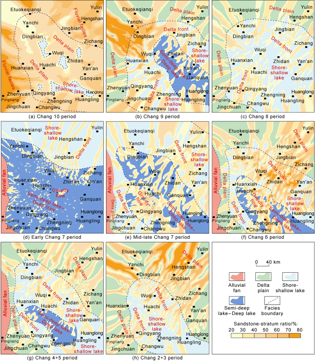
Fig. 3. Sedimentary facies of deposition periods different members of Yanchang Formation in Ordos Basin. |
Although the Yanchang Formation is a set of continuous clastic deposits, its sedimentary process is clearly influenced by tectonic activities, manifested by the significant subsidence in the southwestern region, the differences in clastic components and sedimentary system types among various members of the Yanchang Formation, and the extensive distribution of gravity flow and tuff deposits [9].
3. Subsidence and sedimentary filling
In Mid-Late Triassic, the Ordos Basin experienced two stages of important subsidence, which occurred in Chang 10 period (stage I) and Chang 7 period (stage II) respectively. There are obvious differences in the location, amplitude, filling characteristics and catchment area between them.
3.1. Subsidence and sedimentary filling in stage I
3.1.1. Subsidence center
There are significant differences among the Chang 10 Member and the overlying Chang 9 Member and the underlying Zhifang Formation. The Chang 10 Member is mainly dark deposits formed in a warm and humid environment, obviously different from the red layer of the Zhifang Formation formed in a dry and hot climate. The continuous thick sandstone is developed in the Chang 10 Member, while the upper part of the Zhifang Formation is composed of interbedded sandstone and mudstone. Scouring surface is a typical contact relationship between the two stratigraphic units, with stable distribution regionally. The difference between Chang 10 Member and Chang 9 Member is that the Chang 10 Member develops thick sand bodies in alluvial plain, and the Chang 9 Member mainly develops interbedded sandstone and mudstone in lake environment. Therefore, logging curves of gamma ray and spontaneous potential of Chang 10 Member show obvious negative amplitudes. In addition, its resistivity logging value is significantly higher due to the low formation water salinity.
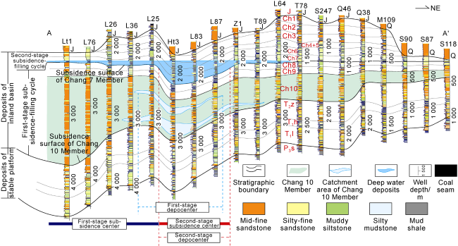
In the past, according to the information of limited drilling and field profiles, it is generally believed that the Chang 10 Member in the south-central part of the basin is thicker than the north, with thickness of 300-400 m in the south. Through the stratigraphic correlation of more than 500 deep wells, it is revealed that ultra-thick Chang 10 Member was deposited in southwestern basin, indicating the existence of a subsidence zone with significant asymmetry (Fig. 4 ). In the area to the north of Etuokeqianqi-Zizhou, the thickness is generally less than 200 m, while in the area to the south of Huanxian-Huachi, the thickness increases sharply, generally greater than 500 m. In which, Huanxian-Zhenyuan-Qingyang-Zhengning areas were the subsidence center, about 800-1 300 m thick and mainly composed of superimposed thick sandstones. The well-tie profile (Fig. 2 ) and seismic section (Fig. 5 ) show the Chang 10 Member taking a wedge shape, thickening from northeast to southwest.
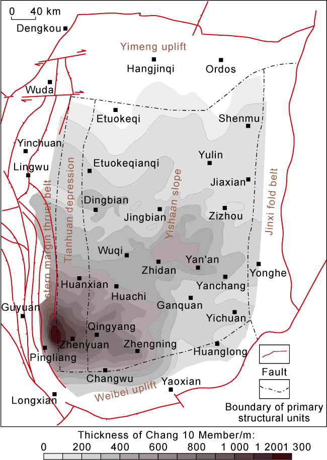
Fig. 4. Thickness of Chang 10 Member in Ordos Basin. |
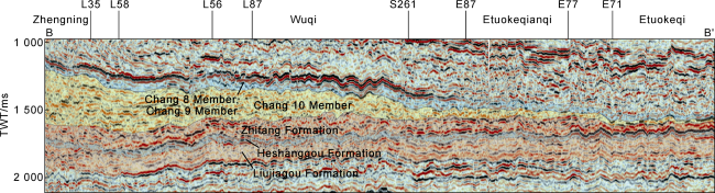
Fig. 5. Seismic reflection characteristics of Middle-Upper Triassic from Zhengning of Gansu to Etuokeqi of Inner Mongolia, Ordos Basin (the section position is shown in |
3.1.2. Sedimentary filling
Compared with other layers of the Yanchang Formation, the clastic grain size of the Chang 10 Member is coarser, and the lithologic assemblage is mainly medium-coarse sandstone and medium-fine sandstone. Some layers near the provenance area contain gravel, and develop large- scale tabular cross-bedding, trough cross-bedding and parallel bedding (Fig. 6 ).
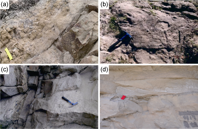
Fig. 6. Sedimentary characteristics of Chang 10 Member of field geological section around Ordos Basin. (a) Chang 10 Member of the Shigouyi section: The lower part is yellow- green medium-coarse sandstone with large-scale cross- bedding, and grain size becomes finer upward, interbedded with calcareous laminae, and gray black carbonaceous mudstone on the top; (b) Chang 10 Member of the Shigouyi section: Yellow-green pebbled medium-coarse sandstone; (c) Chang 10 Member of the Rujigou section: Gray green pebbled coarse sandstone, coarse sandstone with dark gray siltstone; (d) Chang 10 Member of the Shiwanghe section: Large trough cross bedding. |
The sandstone-stratum ratio of Huanxian-Zhenyuan area in the southwest is abnormally high, generally 70%- 95%, and the strata thickness is large (800-1 300 m). The area to the northeast of Zichang-Hengshan-Etuokeqianqi also has the characteristic of high sandstone-stratum ratio (about 60%-75%), but the thickness is smaller (mainly 50-200 m) (Figs. 3 and 4 ).
In the area between Dingbian-Huachi-Heshui and Ansai-Jingbian-Etuokeqianqi, the sandstone-stratum ratio is lower (mostly less than 50%). Hereinto, the ratio in Qingyang-Huangling, Zhidan, Wuqi and other areas is mostly less than 40% (Fig. 3 ), where mudstone is relatively developed. Some areas have lacustrine fossils (such as ostracods) and vertical wormholes on mudstone surface, with rare fossils of higher plants (Fig. 7 ), and deformed bedding is developed in sandy sediments, showing the characteristics of underwater deposits.
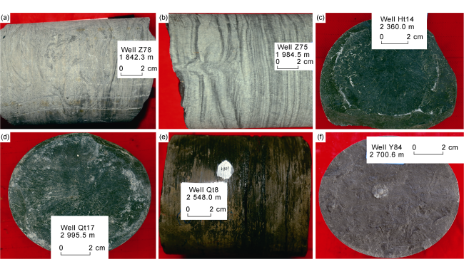
Fig. 7. Sedimentary characteristics of catchment area of Chang 10 Member in Ordos Basin. (a) Well Z78, gray green fine sandstone, deformed structure; (b) Well Z75, gray green fine sandstone with gray, dark gray silty, argillaceous laminae, water escape structure; (c) Well Ht14, grayish black mudstone; (d) Well Qt17, grayish black mudstone; (e) Well Qt8, black mud shale; (f) Well Y84, dark gray mudstone, vertical wormhole. |
3.1.3. Development characteristic of lake basin
During Chang 10 period, the basin subsided rapidly, especially serious in the southwestern region. The subsidence center was filled with thick coarse clasolites, and the thickness of medium-coarse sandstone was more than one km, formed by repeated scouring and superimposed channel sand bodies in alluvial plain. The delta front and the shallow lake were developed at the front end of the sedimentary system. At this time, the unified large lake had not yet taken shape, and only several separated small catchments existed in the basin. The Pr/Ph value of saturated hydrocarbons of mudstone in Chang 10 Member is relatively high (generally 1.1-2.9), and V/Cr value and V/(V+Ni) value is 1.0-1.9 and 0.6-0.7 respectively, indicating that it is formed in a relative oxidizing environment with poor oxygen-rich oxygen. The mudstone contains a certain amount organic matter, and TOC is generally 0.5%-1.0%. The maturity of organic matter is moderate, and the Ro values are ordinarily 0.8%-1.2%.
In general, the Chang 10-Chang 8 period was the development stage of the Ordos Basin, and the lake range was expanding gradually. Controlled by tectonic movement, the basin experienced a rapid and huge subsidence during the Chang 10 period, whereas no deep-water deposition was seen both in the subsidence center and the depocenter, indicating sufficient debris supply. The huge accommodation space generated by rapid subsidence was quickly filled by debris, with feature of settling while depositing. The Chang 10 period was a climate transitional stage from hot and dry to warm and humid. Some thin mudstone and silty mudstone in brownish red or purple red can be seen in the lower part of Chang 10 Member locally. During the periods of Chang 9 and Chang 8, the tectonic environment was relatively stable, and the sedimentation was mainly controlled by climate. Local climate variation made different scale, depositional combination, range and water depth of sedimentary system in the lake basin, but it presented as an overall variation in the basin. Hence, the thickness of Chang 8-Chang 9 Members changed little in basin, with rich plant fossils. During the period, the water of the lake basin transgressed obviously relative to Chang 10 period, the terrain extended gently, and shallow lake and delta were the dominated sedimentary facies. Some areas were swamped where carbonaceous mudstone and inferior coal seam often appear [35]. The organic-rich mud shale is developed at some layers of the Chang 9 Member in Zhidan-Yichuan areas [36], which is a set of important source rock. Consequently, the climate of Chang 8-Chang 9 period was more humid than that of Chang 10 period. The Chang 10 Member is the result of coarser clastic filling in the large-scale tectonic-controlled subsidence zone, while the Chang 8 and Chang 9 Members are climate-controlled finer-grained sediments under the stable tectonic environment. Chang 10 to Chang 8 members constitute the first stage of subsidence-filling cycle of the Yanchang Formation (stage I). This cycle is 1 000-1 550 m thick in the subsidence center, and grain size becomes finer upwards.
3.2. Subsidence and sedimentary filling in stage II
3.2.1. Characteristics of subsidence center
The second-stage subsidence occurred in the early Chang 7 period. Based on the early development, the basin subsided once again under the influence of the Qinling Orogeny, and a deep-water depression was formed, where the black and gray-black organic-rich shale was well developed, presenting lamellation or block structure. It is generally 20-60 m thick and can reach more than 100 m locally, and is the major hydrocarbon source rock of Mesozoic reservoir in the basin. Its logging curves have the characteristics of high resistivity, high gamma ray, high acoustic time difference and low density. Thin tuff layers were developed at the bottom of Chang 7 Member, which can be regarded as isochronous sedimentation, with the characteristics of low resistivity, low density, high gamma ray and high acoustic time difference, with lamellar occurrence. The thickness of a single tuff layer is about 0.1-10.0 cm and reaches about 1 m locally. The accumulated thickness of the tuff decreases in northeast gradually and finally disappears, indicating that the volcanic eruption of the time mainly occurred in the southwestern and southern margins of the basin [9-10,37]. The lithologic association of black mud shale and varicolored tuff in the middle and lower parts of the Chang 7 Member is obviously different from that of the underlying delta and shallow lake deposits of the Chang 8 Member [10,35]. Vertically, the interface between the Chang 7 Member and the Chang 8 Member is a sedimentary surface of discontinuity, and there are distinct different sedimentary features above and below the interface.
The deep depression was developed to the climax amplitude during the early Chang 7 period, with lake area more than 10×104 km2, and the semi-deep lake to deep lake area reaching 6.5×10⁴ km2 (Fig. 3 ), filled with deep-water mud shale and gravity flow sandstone. In the sedimentary center, deep-water deposition lasted from Chang 7 period to Chang 4 + 5 period. The largest lake flooding occurred during initial Chang 7 period, with the deepest water. Previous studies suggested that in the basin, the sedimentary center, which was the relatively deep water area, and was obviously affected by the subsidence of the basin, reflected or represented the subsidence center [4]. Therefore the thickness of the deep-water deposition (the cumulative thickness of the semi-deep lake to deep lake mud shale and interbedded gravity flow sandstone from Chang 7 Member to Chang 4+5 members) can be used to reflect the increased accommodation space by the second stage subsidence.
Through analysis of more than 2 300 wells, combined with sedimentary facies research, it is revealed that the area with the thickest deep-water sediments is located in Mahuangshan-Huachi-Huangling areas, generally 120-320 m thick. The deep-water depression lake basin has the characteristics of steep in the west and gentle in the east. There are many sub-depressions such as Mahuangshan- Qingyang, Huachi-Huangling, and Wuqi-Fuxian, in which sedimentary thickness is generally more than 160 m (Fig. 8 ).
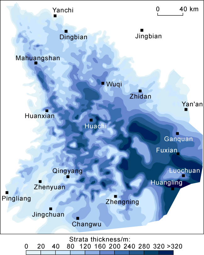
Fig. 8. Deep-water sedimentary thickness of accommodation space by second-stage subsidence during Mid-Late Triassic, Ordos Basin. |
3.2.2. Sedimentary filling
A set of organic-rich shale was deposited during the initial subsidence stage, with dozens to hundreds thin or laminated tuff layers. Accompanied by the strengthened supplying of terrigenous clastic materials, the gravity flow event sediments became frequent and widely developed in semi-deep lake and deep lake, induced by the frequent tectonic events in mid-late Chang 7 period, and the gravity flow sand bodies were broadly developed in the subsidence center. Gravity flow sandstones such as slump rock, arenite and turbidite can be easily transported along the surface of the water-rich smooth muddy slope, accumulated at the slope foot, and formed new sedimentary slope breaks advancing to the depocenter. Therefore, thick sand zone caused by gravity flow, extends parallel to the sedimentary facies boundary and advances to the depocenter continuously. The filling process of deep-water sediments lasted from the Chang 7 period to the Chang 4+5 period. The scale of gravity flow sandbodies was the greatest in the mid-upper Chang 7 period. With the shrinkage of the lake basin, its distribution range and scale decreased gradually (Fig. 3 ).
3.2.3. Development characteristic of lake basin
The formation of the deep-water depression in the early Chang 7 period is the result of the combined effect of tectonic events and storm climate events. Constrained by tuff age at the bottom of Chang 7 Member, it can be inferred that the formation time of the deep-water depression is 228.2-239.7 Ma [9,37⇓ -39], which coincides with the global Carnian Pluvial Episode (CPE) in time. Therefore, the tectonic activity provided a large accommodation space, while the CPE contributed to the formation of unified and vast deep-water depression. The location of the depocenter was the same as that of the subsidence center approximately, which is one of the main characteristics of this subsidence different from the subsidence during stage I. The Pr/Ph value of mud shale is lower (generally 0.5-0.9), and the distribution range of V/Cr value and V/(V+Ni) value is 1.7-8.8 and 0.7-0.9, respectively, indicating that mud shale was formed in an oxygen- poor and anoxic closed environment. Mud shale is extremely rich in organic matter (TOC is 1.3%-32.6%, with an average of 13.8%). The maturity of organic matter is moderate, with Ro value generally 0.7%-1.0%.
In the early forming stage of the deep-water depression lake basin, the basin was in an under-compensated state, mainly filled by argillaceous sediments. With the detrital materials continuous input into the deep lake and depocenter, the basin experienced a process from under-compensation to compensation, and lake basin scope and water depth decreased. The semi-deep lake and deep lake were approximately filled up since the Chang 3 period, the terrain was gentle, and the shallow lake and delta deposits were developed (Fig. 3h ). Then the basin became swamped, and the coal seams occured in northern Shaanxi during the Chang 1 period. Therefore, the Chang 7-Chang 1 Members constitute the second subsidence-filling cycle of the Yanchang Formation (stage Ⅱ), about 500-700 m thick, which presents as a progradation sequence under the background of lake regression, with grain size becoming coarser upwards.
4. Comparison between two stages of subsidence-filling and forming mechanism
The similarities and differences between the two stages of subsidence in the Ordos Basin in Mid-Late Triassic were comprehensively analyzed based on the morphology of the subsidence zone, the position relationship between the subsidence center and the depocenter (Table 1 and Fig. 9 ).
Table 1. Comparison of two-stage subsidence characteristics in the Mid-Late Triassic, Ordos Basin |
| Period | Tectonic environment | Shape of subsidence zone | Subsidence rate | Compensation state of lake basin | Filling characteristics | Relationship between subsidence center and depocenter | Sedimentary type | Characteristics of catchment area |
|---|---|---|---|---|---|---|---|---|
| Stage I | Compression | Strong asymmetry | Rapid | Compensation, simultaneous settling and filling | Fast filling of coarse clastic, pebbled medium-coarse sandstone, medium-fine sandstone and mudstone | Apparently separated | Alluvial plain, delta, and local shallow lake | Separated small lake basins, shallow water, poor-rich oxygen environment |
| Stage II | Weak extension | Asymmetry | Stable | Under-compensation to compensation, subsidence dominated in early Chang 7 period | Slow filling of fine clastic, mud shale, silty-fine sandstone | Basically consistent | Semi-deep, deep lake, gravity flow and tuff | Unified large lake, deep and wide lake, oxygen-poor and anoxic closed environment |
Fig. 9. Location relationship of two-stage subsidence centers and depocenters of Yanchang Formation in Ordos Basin (see |
4.1. Comparison of two stages of subsidence and filling
There are obvious differences between the two stages of subsidence. The Chang 10 period was featured by rapid subsidence, with simultaneous subsidence and sedimentation. In Huanxian-Zhenyuan-Zhenning subsidence center, the thickness of the first-stage subsidence-filling cycle (equivalent to the Ladinian) is generally 1 000-1 550 m, It is estimated that it took 3-14 Ma to complete the process of subsiding and filling up. The geological age of the cycle bottom is 242 Ma, taken the bottom age of the Ladinian according to the International Chronostratigraphic Chart[40], and the age of the cycle top came from the zircon U-Pb dating sampled from the tuff at the bottom of the Chang 7 Member, 228.2-239.7 Ma. Chang 9 and Chang 8 members have finer grain sizes and slower sedimentation rates, while the deposit rate of coarse clastic material in Chang 10 Member is fast, indicating that subsidence and supply were fast during the Chang 10 period. The subsidence was larger and strongly asymmetric, with the depocenter noticeably deviating from the subsidence center. On the side of the subsidence center, the slope was steeper, and rapid subsidence was accompanied by the rapid compensating deposition of coarse debris. At the front end of the subsidence center, the slope became gentler, the sand-carrying capacity of water weakened, sediment particles became finer, the mud content increased, and several small shallow catchment areas were developed.
Late subsidence resulted in a deep-large lake basin. The thick deep lake shale in the lower Chang 7 Member and the shallow lake sediment in the upper Chang 8 Member are separated by the thin tuff layer (commonly a few cm thick only). Frequent tuff layers and superimposed gravity flow deposits are developed in the subsidence zone. These phenomena indicate that the deep- water depression is stable subsidence under active tectonic background. Compared to the early subsidence, the late had relative smaller scale and weaker asymmetry, with the position of subsidence center coincided with that of depocenter. The basin bottom showed a shape being steep in the west and gentle in the east. The sediment filling style illustrates that the late subsidence was featured by stable subsidence and slow filling of fine-grained materials, undergoing a depositing process from earlier under-compensation to later compensation deposition.
4.2. Discussion on subsidence mechanism
In the Indosinian tectonic movement period, the basin- forming dynamics mainly came from the western Qinling Mountains, where the Mianlüe Ocean subducted and North China plate collided with Yangtze plate. Under the unbalanced tectonic stress, the subsidence centers and depocenters of the two stages were located in the southwest of the basin. The migrating evolution of the subsidence zone and the depocenter was closely related to the simultaneous tectonic activities of the Qinling orogenic belt [9,21]. The mountain-basin coupling evolution pattern and periodic cycle were the structural manifestations of plate interaction.
The Qinling Orogeny process during the Mid-Late Triassic was accompanied by extensive magmatic activity, which can be divided into two stages (235-250 Ma and 185-235 Ma) [41]. The early granitic rocks belong to I-type mainly, and the rock types are mainly quartz diorite and plagiogranite, some with higher ratios of Sr to Y content[41-42], indicating the result of northward subduction of the Mianlüe Ocean. The late granites are widely developed in the western and southern Qinling Mountains and sporadically exposed in the eastern Qinling, and are mainly composed of granodiorite and monzonitic granite, with the geochemical feature of I, I-A, and A-type granites. Adakitic-textured granite and rapakiwi granites are also developed, which are formed in the stages of syn-collision to post-collision [42⇓-44], indicating that the Qinling area have evolved into intraplate stage, under extensional tectonic dynamic setting.
Compared with the Indosinian tectonic movement of Qinling orogenic belt, the subsidence of the Chang 10 Member was related to the northward subduction of the Mianlüe Ocean in compressive dynamic setting. Under the tectonic setting, the basin was depressed intensively, forming a subsidence zone in the southwestern region of Huanxian-Zhenyuan-Zhengning areas. The total settlement in the subsidence center is more than one kilometer, with significant asymmetry. The subsidence further strengthened the topography feature (high in the north and low in the south) of the basin since the Late Paleozoic, and the thickness of the Chang 10 Member increased rapidly in a wedge shape from north to south.
The late subsidence was formed under a weak extensional tectonic dynamic environment. The magmatism, aged 185 Ma to 235 Ma in the Qinling Mountains, was generated in an extensional dynamic environment. Siliceous rocks, ferrodolomite lamination deposits, and a coexisting system of siderite-pyrite-anhydrite were discovered in the Chang 7 Member of the basin. It is speculated that they were related to the hydrothermal activity of the lake floor and indicating that the basin was in an extensional structural environment at that time [4,45]. Under this dynamic setting, the basin underwent stable subsidence, and together with climatic factors, the Ordos Basin evolved in the largest lake flooding phase, with the represented sediments of "Zhangjiatan Shale". The Mahuangshan-Huachi-Huangling area was both the depocenter and subsidence center of the depression, in which sub-depressions were distributed with thicker deep-water deposits. The influencing factors on deposition in inland basins are complex. Many natural conditions (such as tectonic activity, debris supplying capacity, water transport ability, amount of rainfall) can affect local deposition. Consequently, the local thick zones of deep-water deposition can be interpreted as the result of uneven subsidence or local climate.
5. Conclusions
The Ordos Basin experienced two stages of significant subsidence in Chang 10 period and Chang 7 period, respectively. According to the subsiding time and the material filling structure in the subsidence zone, the Yanchang Formation can be divided into two subsiding-filling cycles: Chang 10-Chang 8 (stage I) and Chang 7-Chang 1 (stage II). In the first-stage cycle, the sediment grains became finer upwards, 1 000-1 550 m thick in the subsidence zone. In the second-stage cycle, the debris particles became coarser upwards gradually, 500-700 m thick.
The Chang 10 Member thickens in a wedge shape from north to south. The subsidence center during the Chang 10 period was located in the Huanxian-Zhenyuan-Qingyang-Zhengning areas, with stratigraphic thickness of 800-1 300 m, rapid subsidence, rapid coarse debris infilling, and simultaneous subsidence and sedimentation. Scoured and superimposed medium-coarse sandstones deposited in channels, and formed thick sand body. At this time, unified large lake had not yet formed, and several small catchment areas were distributed in the basin.
During the Chang 7 period, under the joint influence of the Qinling orogenic activity and Carnian Pluvial Episode (CPE), a widely flooded Ordos Basin was taking shape. The subsidence in this period has the characteristics of stable subsidence and slow filling, and the subsidence center coincided with the depocenter in the Mahuangshan-Huachi-Huangling areas. The thickness of deep-water sediments in the subsidence zone is 120-320 m, dominated by fine-grained sediments. After the Chang 7 period, along with the filling of deep depression, the lake became shallower, the deep-water area shrank, and the scale of gravity flows decreased gradually.
Both the two stages of subsidence were responses to the Indosinian tectonic movement of the Qinling area. The early subsidence was controlled by the subduction of the Mianlüe Ocean and the plate collision in the Early- Middle Triassic, while the late subsidence was influenced by the weak extension dynamic environment in post- collision stage. The two stages of subsidence show significant differences in the morphology of subsidence zone, the distribution of subsidence center and depocenter, and the texture of sedimentary filling.
Both the two stages of subsidence have significant implications for the abundant Mesozoic petroleum resources in the Ordos Basin. An ultra-large lake basin was formed under the combined action of the two stages of subsidence. In Chang 7 and Chang 9 periods, semi-deep to deep lake areas covered a wide range in which high-quality source rocks were developed with big thickness, good organic matter type, high organic abundance, and moderate thermal evolution. The mudstone of the Chang 10 Member in the catchment area is a set of potential source rock. The Yanchang Formation is a large- scale reservoir of the low permeability-unconventional oil-bearing system constituted by the sand bodies resulted from gravity flow and delta of the Chang 7-Chang 1 subsiding-filling cycle, along with the sand bodies resulted from delta and shallow lake beach-bar of the Chang 10-Chang 8 subsiding-filling cycle.