

Introduction
The global petroleum industry has advanced from conventional oil and gas to unconventional oil and gas through theoretical innovations and technological progress in petroleum geology [1]. In the early 1960s, Hu [2] proposed the concept of oil-formation system after summarizing the law of oil and gas formation and distribution in the Songliao Basin, NE China. He believes that "the formation and distribution of oil and gas reservoirs is the result of the development of geological history". The theory of petroleum system was proposed in the 1970s [3]. It means to search all oil and gas reservoirs around effective source rocks and study the necessary geological elements and processes [4⇓⇓-7]. Since it was proposed, how to classify and evaluate petroleum system has become an important method for explorers to effectively predict and discover oil and gas resources, and it plays an important role in promoting the exploration of conventional oil and gas [7]. Unconventional oil and gas, represented by tight oil and gas and shale oil and gas, have gradually become an important field of oil and gas exploration and development in China since 2010 [1,8⇓ -10]. The theory of petroleum system based on conventional oil and gas has been unable to meet the needs of the development of oil and gas industry, and the traditional petroleum geology theory has been inadaptable. So the concept of whole petroleum system (WPS) based on conventional oil and gas and unconventional oil and gas emerged [11⇓-13]. A WPS refers to a natural system consisting of all geological elements and processes and oil and gas generated by one or several interrelated effective source rocks from generation and evolution to unconventional continuous accumulation in conventional traps, and late adjustment and transformation [11]. The WPS theory, a major innovation in petroleum geology theory in recent years, covers all oil and gas resources related to effective source rocks in petroliferous basins, and emphasizes all geological elements related to oil and gas accumulation, the whole process of interaction, the whole series of resource distribution, and the full scope of research and evaluation.
As one of the seven major oil and gas basins in China, the Qaidam Basin contains abundant oil and gas resources. According to the preliminary results of the fourth resource evaluation conducted by China National Petroleum Corporation (CNPC in brief), the Paleogene in the western depression of the Qaidam Basin (Western Qaidam Depression in brief) is one of the most significant Cenozoic petroleum systems. There exist 24.38×10⁸ t of conventional oil resources, 6 315×108 m3 of natural gas, and 21×108 t of shale oil [14⇓-16]. It is a unique plateau petroleum system in the world. Especially since 2021, based on the Yingxiongling shale oil, the Qinghai Oilfield has strengthened the research of geology-engineering integration. A favorable area of 210 km2 was defined, and the average output of 4 horizontal wells on Pad YY 2H is 15-20 t/d per well. Exploration and development practice has proved that the Paleogene conventional and unconventional oil and gas coexist orderly in the Western Qaidam Depression and have a high exploration and development potential. The Depression has become an important field for increasing oil and gas reserves and production in Qinghai Oilfield. Taking the Paleogene in the Western Qaidam Depression as a case, this paper analyzes the coexisting and continuous accumulation model of conventional and unconventional oil and gas under the frame of the WPS theory. The findings will enrich the WPS theory for continental lacustrine basins and deepen the understanding of conventional and unconventional oil and gas distribution and promote the integration of exploration and development in the Western Qaidam Depression.
1. Geological setting
The Qaidam Basin located in the north of the Qinghai-Tibet Plateau is a large continental Mesozoic-Cenozoic intermountain oil-bearing basin in western China [17⇓-19]. Affected by plateau uplift and peripheral strike-slip orogeny, its shape is an irregular diamond wide in the west and narrow in the east. The Western Qaidam Depression in the west of the Qaidam Basin starts from the eastern margin of the Altun Mountain to the Eboliang-Gansen line, and covers an exploration area of 3.6×10⁴ km2 (Fig. 1a ). During the Paleocene-Miocene period, the Western Qaidam Depression was a compressional depression and began to accept a large quantity of sediments. However, affected by the neotectonic movement from the end of the Pliocene to the beginning of the Quaternary, sedimentation ended completely, and at the same time, the central part of the depression began to invert into intrabasin mountains, and a thick interval was denudated [20-21]. From the perspective of structural characteristics, the most important tectonic deformation of the Western Qaidam Depression is the development of successive folds. The tectonic lines and major faults are almost NW-SE [22-23], and many anticlines are in rows and belts (Fig. 1b ).
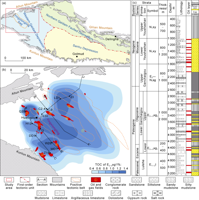
Fig. 1. Division of structural units and location of the Qaidam Basin (a), oil and gas distribution in the Western Qaidam Depression (b), and comprehensive stratigraphic histogram (c) (modified after Reference [14]). ① Gasikule, ② Kunbei, ③ Shizigou, ④ Wunan, ⑤ Hongliuquan, ⑥ Yingxiongling, ⑦ Kaitemilike, ⑧ Youquanzi, ⑨ Nanyishan, ⑩ Xianshuiquan. |
Since the Cenozoic, with the activities of the Altun and East Kunlun orogenic belts, the sedimentary center has continuously migrated from west to east. From the bottom up, there are the Lulehe Formation (E1-2l), the lower part of the lower Ganchaigou Formation (E2-3xg1), and the upper part of the lower Ganchaigou Formation (E2-3xg2) in the Paleogene, and the upper Ganchaigou Formation (E3-N1sg), the lower Youshashan Formation (N1xy) and the upper Youshashan Formation (N1sy) in the Neogene. Specifically, E2-3xg2 and E3-N1sg are two main source rock systems (Fig. 1c ).
2. The Paleogene WPS in the Western Qaidam Depression
The E2-3xg2 effective source rocks lay the foundation for the Paleogene WPS in the Western Qaidam Depression. The reservoirs include the sandstone of E1-2l, the conglomerate and sandstone of E2-3xg, and the thin bedded dolostone and limestone of E2-3xg2. The cap rock is the gypsum salt rock relatively stably distributed at the top of E2-3xg2. A single gypsum salt rock is 2 m to 10 m thick, totally 200 m to 300 m and over 700 km2 (Fig. 1c ).
During the Paleogene period, from the front of the Altun Mountain to the Yingxiongling Sag to the Mangya Sag (Fig. 2 ), a complete sequence was formed from the basin margin to the slope zone and then to the deep depression zone of the lake basin. Sedimentary facies, rock types, and reservoirs are distributed orderly: (1) sedimentary facies: from fan delta-braided river delta-beach bar to limy dolomitic flat-muddy dolomitic flat to semi-deep- deep lacustrine mixed source sediments; (2) rock types: from sandy conglomerate-gravelly sandstone at the basin margin to algal limestone-tight carbonatite in the slope zone to laminar limestone-thin-bedded limestone- laminar clayey shale and other mixed rocks; (3) reservoirs: lithologic-structural reservoirs at the basin margin, structural and structural-lithologic reservoirs in the slope, and shale oil in broad sense in the center of the lake basin (Fig. 2 ). The Western Qaidam Depression has experienced an evolution process of "first depression and then uplift". In a broad sense, the shale oil reservoir is oil and gas accumulation in the source rock under the influence of strong structural transformation. It is significantly different from the Gulong shale oil enrichment model in Daqing Oilfield, featured by "generation and inner-source storage" on a stable tectonic setting [9,24].
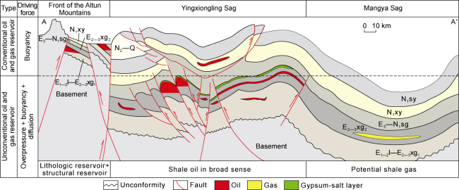
Fig. 2. Distribution of the Paleogene WPS in the Western Qaidam Depression (section location shown in |
The Paleogene WPS in the Western Qaidam Depression mainly includes the deep conventional oil and gas in Gasikule, Kunbei, Shizigou and Wunan, shale oil in Hongliuquan-Yuejin, and Yingxiongling and shale gas in Mangya (Table 1 ). Furthermore, the deep oil fields in Gasikule, Kunbei, Shizigou, Wunan, Hongliuquan-Yuejin are primarily in front of the Altun Mountain and the slope zone of the Yingxiongling Sag. The reservoirs are lithologic and structural, and buoyancy is the major force to drive oil and gas migration and accumulation. Typical unconventional oil and gas reservoirs are developed in the Yingxiongling Sag and the Mangya Sag where overpressure, buoyancy and diffusion are major forces driving oil and gas migration and accumulation (Fig. 2 ). The incomplete estimation of oil and gas resources in the Paleogene WPS in the Western Qaidam Depression is about 40×108 t of oil equivalent (Table 1 ).
Table 1. Geological characteristics and resource potential of the oil and gas reservoirs in the Paleogene WPS in Western Qaidam Depression |
| Type | Zone | Source rock | Sedimentary facies | Reservoir | Depth/ m | Thickness/m | Area/ km2 | Poro- sity/% | Perme- ability/ 10-3 μm2 | Reservoir space | Pressure coefficient | Resource potential/ 108 t | |
|---|---|---|---|---|---|---|---|---|---|---|---|---|---|
| Conventional oil and gas | Structural hydrocarbon reservoir | Deep Gaskule (E1-2l) | E2-3xg2 | Delta, beach bar | Fine sandstone and siltstone | 3 178 - 3 864 | 20-50 | 4 225 | 12.0- 20.0 | 10.00- 300.00 | Intergranular pores | >1.70 | 5.00 |
| Kunbei (E1-2l+ E2-3xg1) | E2-3xg2- N1sg | Braided river delta front | Lithic feldspar sandstone | 1 600 - 2 300 | 100 | 3 494 | 14.6 | 15.55 | Intergranular pores, intragranular dissolved pores | 1.60- 1.70 | 3.00 | ||
| Deep Shizigou (E2-3xg2) | E2-3xg2 | Shore-shallow lacustrine and semi-deep lacustrine | Limestone, argillaceous limestone | 2 300 - 4 500 | 30 | 684 | 6.0 | 0.09 | Intercrystalline pores, dissolution pores, fractures | 2.16- 2.28 | 5.00 | ||
| Lithological- structural reservoir | Kunbei (E1-2l+ E2-3xg1) | E2-3xg2- N1sg | Braided river delta front | Lithic feldspar sandstone | 1 600 - 2 300 | 100 | 3 494 | 12.7 | 5.10 | Intergranular pores | 1.70- 1.80 | 1.50 | |
| Wuna (E1-2l+ E2-3xg1) | E2-3xg2 | Braided river delta-shore- shallow lake | Fine sandstone | 2 700 - 5 000 | 30 | 406 | 7.7 | 0.26 | Intergranular pores | 1.00- 1.20 | 1.50 | ||
| Unconventional oil and gas | General shale oil | Hongliuquan- Yuejin (E3-N1sg) | E2-3xg2 | E32: shore- shallow lacustrine E31: braided river | E32: limestone E31: silt/fine sandstone | 2 500 - 4 000 | 80 | 402 | E32: 10.0 E31: 12.4 | E32: 1.00 E31: 39.70 | E32: dissolution pores, fracture E31: secondary pores | 1.00- 1.20 | 2.50 |
| Yingxiongling (E2-3xg2) | E2-3xg2 | Semi-deep and deep lacustrine | Thin-bedded limy dolostone, laminar limy dolostone | 2 500 - 5 500 | 100 | 210 | 4.5 | 0.03 | Dolomite intercrystalline pores, lamellar cracks | 1.88- 1.96 | 21.00 | ||
| Potential shale gas | Mangya sag (E3-N1sg) | E2-3xg2 | Shallow- semi-deep lacustrine | Thin-bedded limy dolostone, laminar limy dolostone | 5 000 - 6 500 | 150 | 1 183 | 4.9 | 0.47 | Dolomite intercrystalline pores | 1.50- 1.80 | 0.25 | |
The typical oil and gas reservoirs in the margin and center of the Western Qaidam Depression are taken as examples to illustrate the characteristics of the representative oil and gas reservoirs in the Paleogene WPS. The Wunan Oilfield is a representative of the lithologic-structural reservoir on the margin of the Western Qaidam Depression, located in the southwest of the Yingxiongling Sag slope zone (Fig. 1b ). The reservoir is fine sandstone and the reservoir space is mainly intergranular pores. Cores and logging data show that the porosity of the reservoir ranges from 8.11% to 20.00%, with an average of 11.5%. The permeability is (0.02-296.90)×10-3 μm2, and 3.54×10⁻³ μm2 on average. Faults are developed in Wunan Oilfield and greatly influence the distribution of the oil and gas reservoir (Fig. 3 ). The formation is at overpressure, and the pressure coefficient is higher than 1.7. As of 2023, the proven geological reserves in Wunan Oilfield are 5 640×104 t.
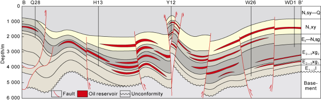
Fig. 3. Paleogene and Neogene Zahaquan-Wunan section in Western Qaidam Depression (section location shown in |
In the center of the Western Qaidam Depression, broad- sense shale oil is dominant and represented by Yingxiongling shale oil [10] which is in-situ retained or migrates for a micro-distance. Yingxiongling shale oil is unique shale oil developed in plateau and has been broken through commercially. Since officially discovered in 2021, Yingxiongling shale oil has been showing a good exploration and development potential. The reservoir is typical fine sediments in the saline lake basin, dominated by laminar dolomite limestone, laminar limy dolostone, laminar clay shale, and thin-bedded limy dolostone, with intercrystalline pores as reservoir space. The reservoir is tight and the porosity is less than 10%. From the perspective of reservoir characteristics, it is thick (more than 1 200 m), and has good quality (the density is 0.78-0.85 g/cm3, and the viscosity is less than 22 mPa·s), and it is at high pressure (the pressure coefficient is higher than 1.8). As of 2023, the estimated well-controlled Yingxiongling shale oil area was 260 km2 with geological resources of 21× 108 t [10], and predicted geological oil reserves of 1.3×10⁸ t.
3. The unique Paleogene WPS in the Western Qaidam Depression
The Paleogene WPS developed in the Qinghai-Tibet Plateau is very unique in three aspects.
3.1. Low organic matter abundance, low carbon and rich hydrogen, strong hydrocarbon generation
The effective source rock of the WPS in the Western Qaidam Depression is E2-3xg2, with total organic carbon content (TOC) greater than 0.4% and an area of about 1.26×10⁴ km2 (Fig. 1b ), and mainly distributed in the southwest part of the Qaidam Basin [14⇓-16,22]. Compared with other typical continental oil and gas basins in China, the TOC of E2-3xg2 is generally lower, but the hydrogen index (HI) is high, showing the characteristics of "low carbon and rich hydrogen".
E2-3xg2 is dominated by laminar dolomitic limestone and laminar clay shale. According to 12 489 typical source rock samples, the TOC ranges from 0.4% to 2.7%. More than 97% samples have TOC less than 2%, and the average TOC is less than 1%. The abundance of organic matter in the Triassic Chang 7 Member in the Ordos Basin and the Cretaceous Qingshankou Formation in the Songliao Basin is much higher than that in E2-3xg2 in the Western Qaidam Depression, but the hydrogen indices of the three types of shale are similar and comparable [10]. Taking Well C2-4 as an example, the analysis of organic geochemical parameters of the source rock in E2-3xg2 shows that the abundance of organic matter is low, TOC values range from 0.3% to 2.0%, with an average of 1.0%. However, the hydrocarbon generation potential of the source rock is good. The (S1+S2) values generally range from 4 mg/g to 10 mg/g and the highest value is 30 mg/g; the S2/TOC values generally range from 200 mg/g to 600 mg/g and the highest value is 720 mg/g; and the S1/TOC values are generally higher than 100 mg/g (Fig. 4 ).

Fig. 4. Comprehensive evaluation of lithofacies, mineral composition, organic geochemical parameters of E2-3xg2 in Well C2-4, Western Qaidam Depression. |
Aquatic algae such as botryococcus and dinoflagellata are primary hydrocarbon parent materials in E2-3xg2 through organic petrology and biomarkers. Green sulfur bacteria and purple sulfur bacteria indicate a reducing environment which is favourable for the enrichment of organic matter [25]. The research of biomarkers shows that a large number of trimethyl isoprene compounds are developed in the source rock of E2-3xg2, indicating the contribution from green sulfur bacteria and purple sulfur bacteria. The algae-dominated hydrocarbon parent material provides good kerogens in the Paleogene WPS in the Western Qaidam Depression. They are primarily I-II1 kerogens accounting for more than 90%. Early hydrocarbon was generated by soluble organic matter, while late hydrocarbon was from the cracking of kerogen, so the unit TOC of the source rock is high. The relationship between HI and TOC (Fig. 5 ) shows that the TOC of the upper member of the lower Ganchaigou Formation is 1.0% when HI is 600 mg/g, the TOC of the Chang 7 Member in the Ordos Basin is higher than 5%, and that of the Qingshankou Formation in the Songliao Basin is 3%. The hydrocarbon generation capacity per TOC of E2-3xg2 is obviously higher in the lacustrine source rocks in China.
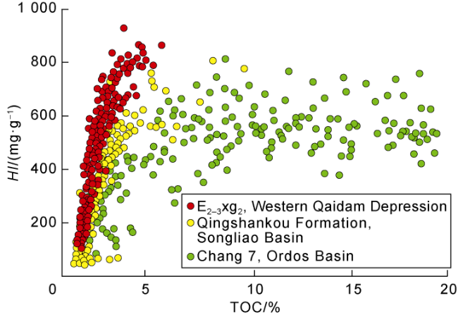
Fig. 5. The relationship between TOC and HI of typical lacustrine source rocks. |
3.2. Ultra-thick sediments, mixed sources, and rapid vertical reservoir changes
When the Paleogene deposited, the Qaidam Basin located at north latitude 30.3° to 33.4° [27] was expanding and subsiding [25-26]. The subtropical arid and semi-arid climate [23,28] made the salinity of the lake basin was higher. During that period, the Yingxiongling Sag, the Mangya Sag, the Xiaoliangshan Sag, and the Zhahaquan Sag were developed in the Western Qaidam Depression. They are independent from each other, but similar in evolution characteristics. Under the influence of terrigenous clastic supply and endogenous carbonate, the lateral distribution of the sedimentary facies is inheritable. From the edge to the center of the lake basin, the sedimentary facies are successively fan delta, braided river delta, beach bar, algal mound and lime mud flat, lime dolomitic flat and granular beach, and semi-deep lacustrine deposits (Fig. 6 ). The sediments in different types are extremely thick, generally exceeding a kilometer. Alkaline minerals, gypsum, halite and other special minerals in saline lake basins are common and developed into gypsum, carbonate and shale (Fig. 4 ).
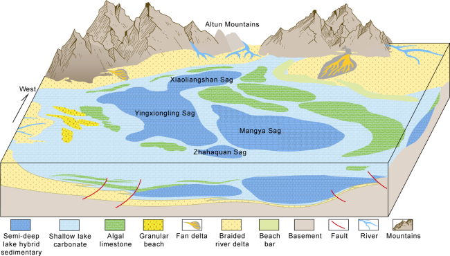
Fig. 6. Paleogeographic pattern of the upper member of the lower Ganchaigou Formation in Western Qaidam Depression (the name of the depression lies in the depositional center of the depression). |
Affected by both exogenous clastic supply and endogenous carbonate, typical deposits from "mixed sources" appeared in the center of the Western Qaidam Depression. For example, the upper member of the lower Ganchaigou Formation in the Yingxiongling Sag is thicker than 1 200 m [21,29], and the lithofacies frequently change vertically. Fig. 4 shows 8 types of lithofacies, including laminar limy dolostone, laminar dolomitic limestone, thin-bedded limy dolostone, thin-bedded dolomitic limestone, laminar clay shale, thin-bedded mudstone, laminar mixed rock and thin-bedded mixed rock, in a 10 m vertical interval. A single layer is 0.2 m to 0.5 m. The mineral composition changes frequently, and lamellar structures are obvious.
The reservoir space of different types of reservoirs is significantly different. The reservoir space of sandstone is composed of intergranular pores and local dissolution pores (Fig. 7a -7c ). High-pressure mercury injection analysis shows that the distribution of pore sizes appears "unimodal", and the radiuses of most pore throats are 5-10 μm (Fig. 7d ). Percolation is the dominant migration way and buoyancy is the main force for reservoir accumulation (Fig. 8 ). The reservoir space of algal limestone is contributed by small pores and large pores. The small pores are mainly dissolution pores and intergranular pores, while the large pores are local cracks and karst caves (Fig. 7e -7g ). High pressure mercury injection analysis shows that the distribution of pore sizes is "bimodal", and the small pore throats are 50-100 nm and the large are 50-100 μm (Fig. 7h ). The migration of oil and gas is mainly through pipe flow and seepage (Fig. 8 ). The reservoir space of laminar limy dolostone is composed of intercrystalline and intergranular pores, and fractures (Fig. 7i -7k ). High-pressure mercury injection analysis shows that micro- and nano-pore throats less than 100 nm are dominant (Fig. 7l ). Crude oil is retained in nanoscale pores and micro-fractures (Fig. 8 ), showing obvious limiting effect.
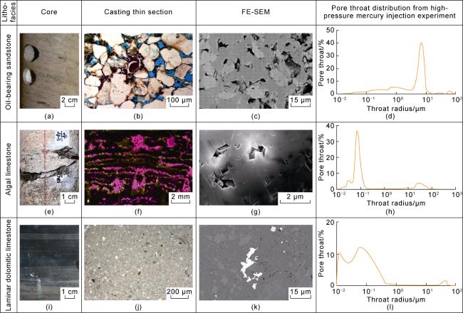
Fig. 7. Comprehensive map of core, thin section, SEM and pore throats from high-pressure mercury injection experiment of Paleogene reservoirs in Western Qaidam Depression. Oil-bearing sandstone — "unimodal" distribution of pore sizes; Lulehe Formation; 3 789.56m; Well SX51; algal limestone — "bimodal" distribution of pore sizes; the upper member of the lower Ganchaigou Formation; 1 382.90m; Well YX4; laminar limy dolostone — micro- and nano-pore throats; the upper member of the lower Ganchaigou Formation; 2 818.45m; Well C2-4. |
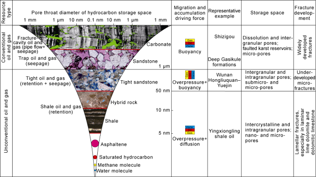
Fig. 8. Comparison of storage space and migration and accumulation driving forces of the Paleogene WPS in Western Qaidam Depression (modified after Reference [1]). |
3.3. Differential oil and gas accumulation in the mountain-style WPS under Himalayan strike-slip extrusion
Compared with other oil-bearing basins in the world, the Qaidam Basin in the Qinghai-Tibet Plateau experienced unique structural evolution. In the context of the collision between the Indian and the Eurasian plates, the Qaidam Basin experienced five tectonic movements of different degrees since the Cenozoic, among which the late Pliocene and the Quaternary tectonic movements had the most intense influences on the tectonic pattern of the Western Qaidam Depression [23,30]. Under the strong Himalayan transformation, the Paleogene of the Western Qaidam Depression was controlled by the East Kunlun and Altun sinistral strike-slip faults, so the central part uplifted to basin mountains from the end of the Pliocene to the Quaternary under strong thrust extrusion. It's a tectonic evolution history of "early depression and late uplift" [16,31]. Strong extrusion and faulting led to the development of strike-slip faults and intense deformation. On the northwest-southeast section (Fig. 2 ) and the nearly north-south section (Fig. 9 ), strike-slip faults on the margin and uplift and denudation in the center are obvious". The closer to the basin center, the more intense the uplift and denudation is.
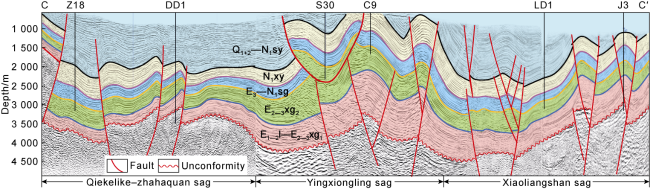
Fig. 9. A typical seismic section of the Paleogene in Western Qaidam Depression (section location shown in |
The Paleogene WPS is defined as a mountain WPS whose key features are strong structural transformation and "dual complexity" (i.e., complicated underground geological and surface conditions). (1) After superimposed transformation of multiple tectonic movements, especially strong Himalayan transformation, the Paleogene WPS in the Western Qaidam Depression became very complex, and the distribution of oil and gas is controlled by different faults and fractures. The salinity of formation water is generally greater than 200 g/L, developing high pressure system in the Paleogene, with the pressure coefficient between 1.78 and 2.48. (2) The Western Qaidam Depression is arid and short of water. Most part is 3 000-3 900 m above the sea level [19,32], with mountains, high and steep slopes and gullies. Oil and gas first retained in the source rock in E2-3xg2, and then migrated upward through open faults and permeable reservoirs under buoyancy and accumulated in lithologic- structural reservoirs. The stable distribution of salt layer at the top of E2-3xg2 provides a good preservation condition for oil and gas accumulation in complex lithologic- structure reservoirs and shale oil and gas.
There are four sags in the Western Qaidam Depression, namely, the Yingxiongling Sag, the Mangya Sag, the Xiaoliangshan sag and the Zhahaquan Sag. The thermal maturity of the Paleogene source rocks is different, which results in the difference of hydrocarbon enrichment in the WPS of the Western Qaidam Depression. The maturity of the source rocks in E2-3xg2 in the Yingxiongling Sag, the Xiaoliangshan Sag and the Zahaquan Sag is similar, and the Ro is 0.8%-1.2% corresponding to oil reservoirs. The source rock in the Mangya Sag is maturer, and the Ro is 1.2% to 1.5%, corresponding to potential large-scale shale gas (Fig. 2 ).
4. Hydrocarbon accumulation model
The Paleogene WPS in the Western Qaidam Depression is the result of a good match among source, reservoir, and cap rock on the background of plateau uplift and strong tectonic extrusion. The orderly accumulation of conventional and unconventional oil and gas shows four characteristics:
From the perspective of the source rock system, the low-carbon and rich-hydrogen source rock produces hydrocarbon continuously, which lays the resource foundation of the WPS. The hydrocarbon parent material in the upper member of the lower Ganchaigou Formation is mainly aquatic algae with types I-II1 kerogen. Early hydrocarbon generation from soluble organic matter and late cracking of kerogen effectively improve the hydrocarbon generation capacity of unit TOC.
From the perspective of the reservoir system, continuous and ultra-thick deposition in the "whole depression" provides favourable reservoir space for the Paleogene WPS. During the Paleogene sedimentary period, the Western Qaidam Depression was expanding, and from the edge to the center of the basin, sedimentary facies gradually changed from clastic to carbonate, and finally to hybrid rock, even over 3 000 m thick in the center of the lake basin. Complex lithofacies association and abundant pores and fractures provide good reservoir space for oil and gas accumulation.
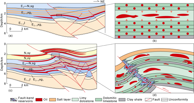
From the perspective of the enrichment model, "first depression and then uplift", structural extrusion and strike-slip faults caused the "all-round" adjustment of oil and gas in the West Qaidam Depression, laying the foundation for differential oil and gas enrichment. Oil and gas accumulation is divided into stages: (1) in-situ retention or micro-migration in laminar clay shale and laminar dolomitic limestone with a good hydrocarbon generation capability, adjacent thin-bedded limy dolostone as a shale oil and gas carrier in broad sense, and dolomite intercrystalline pores and lamellar fractures as reservoir space (Fig. 10a , 10b ); (2) oil and gas migrated upward through strike-slip faults and accumulated in algal limestone and sandstone as lithologic-structural oil and gas reservoirs with intergranular and intercrystalline pores. In the flowerlike fault development zone in the western Yingxiongling Sag (such as Well Shixin 58), penecontemporaneous karst and organic acid caused strong dissolution and "karst caves" in the algal limestone, in which oil and gas accumulated (Fig. 10c , 10d ).
Fig. 10. The shale oil accumulation model in the center of Western Qaidam Depression. (a) Early N1xy tectonic pattern; the upper member of the lower Ganchaigou Formation had begun to generate hydrocarbon; (b) in-situ retention and macro-migration; intergranular and laminar fractures; local amplification of |
From the perspective of oil and gas distribution, the "full-composition" and continuous distribution of conventional and unconventional oil and gas constitute the basic framework of the WPS. From the edge to the center of the basin, structural reservoirs, lithologic reservoirs, shale oil and shale gas are orderly distributed laterally, and locally superimposed vertically, forming a "whole series" and orderly pattern (Fig. 2 ).
5. Conclusions
The Paleogene WPS in the Western Qaidam Depression is the most potential hydrocarbon system in the Cenozoic in the Qaidam Basin, with structural reservoir, lithological-structural reservoir, shale oil and gas developed from the edge to the center of the lake basin around the effective source rock system in the upper member of the lower Ganchaigou Formation.
The Paleogene WPS is a unique thick mountain-style WPS which has three unique aspects: (1) The source rocks with low abundance of organic matter are "low in carbon but rich in hydrogen", providing a strong hydrocarbon generation capacity per unit TOC; (2) The sediments are thick and hybrid in the center of the depression, and vertically heterogeneous in lithofacies and reservoir space; and (3) Himalayan strike-slip faults and extrusion resulted in differential enrichment of oil and gas in the mountain-style WPS.
Shale oil in broad sense is developed in the center of the lake basin. Controlled by strong Himalayan tectonic movement, the Western Qaidam Depression undergone "first depression and then uplift", resulting in hybrid sedimentary system with thickness more than 2 000 m. Oil and gas are orderly distributed in the thin-bedded limy dolostone in the source rock system and the algal limestone adjacent to the hydrocarbon generating kitchen. Dolomite intercrystalline pores, laminar fractures, and karst caves are effective reservoir spaces.
The Paleogene WPS is the result of a good match among source, reservoir and cap rocks, reflected by "whole process" and continuous hydrocarbon generation by low-carbon and rich-hydrogen source rocks, continuous and ultra-thick sediments in the "whole depression", "all-round" adjustment by extrusion and strike-slip faults, and "whole series" and continuous distribution of conventional and unconventional oil and gas.
Acknowledgments
We appreciate Academician Jia Chengzao, PetroChina Company Limited, Professor Zhu Rukai and Dr. Jiang Lin, PetroChina Research Institute of Petroleum Exploration and Development, and Professor Pang Xiongqi and Professor Song Yan, China University of Petroleum (Beijing), for their guidance to this work. We are also grateful to Professor Zhang Yongshu, Professor Xue Jianqin, Zhao Jian, Zhang Jing, Zhang Na, Zhang Menglin, Li Yafeng, Deng Liben, Huang Jianhong, Lu Zhenhua and Wang Zhuanzhuan, PetroChina Qinghai Oilfield Company, for their assistance to the study.