

Introduction
The Baiyun Sag is an important exploration area in the deep-water area of the Pearl River Mouth Basin, China. It is located in the northeast of Zhu II Depression in the southern Pearl River Mouth Basin. Its main body is located on the seaward thinning continental margin lithosphere, and its water depth generally exceeds 500 m. After many years of exploration, multiple large and medium-sized oil and gas fields have been discovered in the Baiyun Sag, forming a distribution pattern of internal gas and external oil that is dominated by gas and supplemented by oil [1-2]. In the past years, researchers have conducted thorough studies on the various elements of the whole petroleum system in the Baiyun Sag [3⇓-5], and have made some progress in the analysis of accumulation factors. However, due to the rarity of wells encountering the Paleogene source rocks and the specialty of high-temperature engineering operations in this area, wells are mostly located in the uplifted areas around the sag, and there are significant differences in the research results on the distribution characteristics, scale, and resource contribution of the Paleogene source rocks. Pang et al. [6] believed that at the sedimentary stage of the Eocene Wenchang Formation, the Baiyun Sag was a large-scale wide and deep faulted lacustrine basin, where large-scale semi-deep and deep lacustrine source rocks were developed. At the sedimentary stage of the Eocene Enping Formation, delta and shallow lacustrine source rocks were extensively developed in the Baiyun Sag. There are significant differences between main oil source rocks and gas source rocks in the Baiyun Sag, with the Enping Formation shallow lacustrine mudstone as the main oil source rocks and the Wenchang Formation sapropel-prone source rocks as the main gas source rocks. Zhang et al. [7] believed that marine source rocks are developed in the southern and deep low lying areas of the Baiyun Sag, while in the northern area, delta coal measure source rocks are developed in the Enping Formation, and shore and shallow lacustrine source rocks are developed in the Wenchang Formation, among which the Enping Formation coal measure source rocks and the marine source rocks are the main source rocks in this area. Gao et al. [8] believed that during the sedimentation of the Wenchang Formation, delta and proximal small lacustrine deposits were developed in the Baiyun Sag. Large-scale shore and shallow lacustrine source rocks are developed in the Wenchang Formation under the control of the source and sink system, while the semi-deep and deep lacustrine source rocks have limited distribution and are only scattered in various sequences. Although the main source rocks of the Wenchang Formation are the shore and shallow lacustrine facies, the high-quality ones are the semi-deep and deep lacustrine facies. With the deepening of geological research, the understanding of source rocks in the sag is gradually strengthened. It is indicated that the characteristics, hydrocarbon generation mechanisms and scale distribution of different types of source rocks, and the geothermal field features in the sag control the distribution of oil and gas resources in the Baiyun Sag. However, the existing basic data for resource evaluation is relatively old and cannot match the latest exploration results in recent years, so it is urgent to reevaluate the oil and gas resources in the Baiyun Sag to support exploration deployment. Therefore, we clarified the characteristics of different types of source rocks in the Baiyun Sag through organic geochemical analysis of core samples from drilled wells. Oil- and gas-source correlations were conducted based on the biomarkers and carbon isotope composition characteristics of discovered oil, gas and different source rocks. The present geothermal field of the sag was reconstructed, and the evolution of tectonic-thermal evolution history was restored. Based on this work, the thermal simulation experiment and numerical simulation were carried out to predict the type, scale, and distribution of hydrocarbon resources in the sag, in order to provide technical support for the exploration deployment of the Baiyun Sag.
1. Regional geological setting
The Baiyun Sag is located in the deep-water area of the continental slope of the southern Pearl River Mouth Basin in the northern South China Sea, with nearly NE-trending overall, where thick Paleogene deposits are developed. It is the largest Cenozoic sedimentary sag found in the Pearl River Mouth Basin so far, with an area of more than 2×10⁴ km2 (Fig. 1a ). It borders the Panyu Low Uplift on the north, the Yunkai Low Uplift on the west, the Yunli Low Uplift on the south, and the Dongsha Uplift on the east. The comprehensive effects of plate tectonic process, tectonic thermal subsidence, and differential sedimentation divide the sag into four hydrocarbon generating sub-sags with different sedimentary fillings and stratigraphic evolution, namely the Baiyun main sub-sag, the Baiyun east sub-sag, the Baiyun west sub-sag, and the Baiyun south sub-sag (Fig. 1b ).
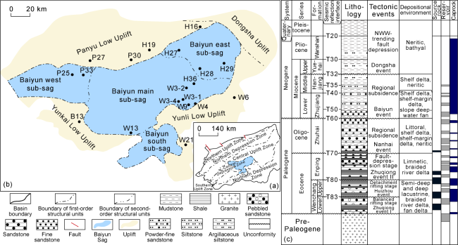
Fig. 1. Structural division of the Pearl River Mouth Basin (a), structural division of the Baiyun Sag (b) and comprehensive stratigraphic column of the Baiyun Sag (c). |
The Baiyun Sag is located in a special structural position of the marine-continental transitional crust near the oceanic crust, and has a complex and special geological background. It is located on the continental margin lithosphere in the northern South China Sea, which is gradually thinning toward the marine basin. It has undergone many tectonic events, such as Zhuqiong event I, Huizhou event, Zhuqiong event II, Nanhai event, Baiyun event and Dongsha event. It has experienced the tectonic evolution history of balanced rifting stage, detachment rifting stage, fault-depression stage and depression stage. And correspondingly, continental rift lacustrine basin deposits of the Lower Eocene Wenchang Formation, large fault-depression lacustrine basin deposits of the Upper Eocene Enping Formation, marine-continental transitional delta facies deposits of the Oligocene Zhuhai Formation, shelf delta, shelf-margin delta and deep-water fan deposits of the Miocene Zhuangjiang-Hanjiang-Yuehai Formation, and clay to silty mudstone of the Quaternary are developed from bottom to top. Thus, a unique basin structure with a lower fault and upper depression, first continent and then marine, and a space-time well configured source-reservoir-caprock assemblage are formed [2] (Fig. 1c ). Since the Nanhai event, with the expansion of the South China Sea, the Baiyun Sag has entered a depression period and gradually evolved into a neritic continental shelf environment, where neritic continental shelf marine-continental transitional delta deposits are developed. After the Baiyun Event (23.03 Ma), the Baiyun Sag experienced intense subsidence due to the influence of deep mantle, and the shelf slope break belt transitioned from the southern part of the sag to the northern part. The sag became a deep-water environment on the continental slope, with the development of large shelf-margin delta and deep-water fan deposition. A large-scale marine transgression occurred at 19.1 Ma, and thick marine mudstone was deposited in the sag, forming an excellent reservoir-caprock assemblage [9]. The Wenchang Formation is divided into six members from bottom to top, namely Wen 6 Member to Wen 1 Member. The Enping Formation is divided into four members from bottom to top, namely En 4 Member to En 1 Member.
The Baiyun Sag mainly develops three sets of source rocks, including lacustrine deposits of the Lower Eocene Wenchang Formation, marine-continental transitional deposits of the Upper Eocene Enping Formation, and marine deposits of the Oligocene Zhuhai Formation (Fig. 1c ). However, the source rocks of the Zhuhai Formation have relatively shallow burial, low maturity, and limited distribution. The types of sedimentary facies of source rocks include semi-deep and deep lacustrine facies, shallow lacustrine facies, coal measures delta and marine-continental transitional facies [10]. In terms of sedimentary characteristics, from the early stage of the initial rifting in the sag (during the sedimentation of Wen 6 Member) to the late stage of the balanced rifting (during the sedimentation of Wen 4 Member), the lacustrine basin gradually expanded and reached its maximum in the Wen 4 Member, and the deposits gradually transformed from braided river delta, fan delta, and shore-shallow lacustrine facies to shallow-semi deep lacustrine facies. Under the control of strong provenance supply from the west and north, differences in the activity of sub-sag controlling faults, and northward migration of subsidence centers, the semi-deep and deep lacustrine facies was only developed in the Wen 4 Member near the sub-sag controlling fault on the southern side of the main sub-sag, and shallow lacustrine source rocks were developed in a large scale in the main part. In the detachment rifting stage (during the sedimentation of Wen 3 to Wen 1 Member), the subsidence center was unified to the Baiyun main sub-sag, and the lacustrine basin was gradually shrunken. The semi-deep lacustrine was mainly distributed in the center of the Baiyun main sub-sag, and the shallow lacustrine sedimentation still covered a large area. The shallow lacustrine mudstone of Wen 3 Member was the most widely distributed. The sedimentary period of the Enping Formation was characterized by a transition from faulting to depression. In the early stage of the Enping Formation sedimentation (during the sedimentation of En 4 to En 3 Member), a large braided river delta of Kontum-Ying-Qiong River was mainly developed on the west side, small braid river deltas were developed in the periphery of the uplift in the Baiyun east sub-sag, and shallow lacustrine facies and marine-continental transitional facies mudstone influenced by marine transgression were distributed in the southeast of the sag. In the late stage of the Enping Formation sedimentation (during the sedimentation of En 2 to En 1 Member), the whole lacustrine basin was covered by delta. Influenced by marine transgression, a set of marine-continental transitional facies and restricted coal measure source rocks was developed. In terms of the distribution of mud shale thickness in different sequences, the Wenchang Formation is much greater than the Enping Formation. The main depression centers of Wen 4 and Wen 3 members have larger mud shale thickness. The mud shale thickness is 1 800-2 300 m in the Wen 4 Member and 1 000-1 500 m in the Wen 3 Member, while the maximum mud shale thickness is about 800 m in the En 4 Member, and only 300 m in the En 1 to 2 Member. From the perspective of distribution and scale, the Wen 4 and Wen 3 members are the main source rock development layers in this area. In addition, the Baiyun Sag exhibits high and variable geothermal characteristics under the background of strong crustal thinning [11]. The high thermal flow field in deep water areas leads to a shallower hydrocarbon generation threshold and a higher degree of thermal evolution of source rocks. The distribution pattern of internal gas and external oil on the plane indicates the coexistence of oil and gas generation by source rocks, with gas being the main product.
2. Geochemical characteristics of source rocks and oil and gas source correlation
2.1. Geochemical characteristics of source rocks
During the rifting period of the Baiyun Sag, the Wenchang Formation and the Enping Formation developed large delta and lacustrine deposits, which are the main source rocks in the Baiyun Sag [6]. In addition, during the process of lithospheric thinning, the gravitational equilibrium caused the surface of the continental margin to sink below the sea level, providing geological conditions for the development of marine source rocks [12]. This also means that the Baiyun Sag has basic geological conditions for the development of multiple sets of source rocks, including lacustrine, marine-continental transitional facies, and marine mudstone.
Different types of source rocks show significantly different biomarkers and paleontological characteristics. The semi-deep lacustrine source rocks of the Wenchang Formation encountered by Wells W3-2, W4 and W9 in the eastern Baiyun main sub-sag have low Pr/Ph ratios of 1.1-1.9, indicating the sedimentary water environment was relatively reductive with a small amount of oleanane and bicadinanes formed by terrestrial higher plants. Moreover, the biomarker C304-methyl sterane, a characteristic biomarker of semi-deep lacustrine source rocks of the Wenchang Formation in the Pearl River Mouth Basin [13], was found in the source rocks of Wen 4 Member in Well W3-2. The carbon isotopes values of kerogen range from -29.2‰ to -28.5‰ (Table 1 ), reflecting that the organic matters of these source rocks are mainly composed of algae [14]. In addition, this type of mudstone has a high content of algae in the assemblage of fossil sporopollen and algae (Table 1 ). It has total organic carbon (TOC) content of 0.9%-1.4% and hydrogen index (HI) of 233-288 mg/g, indicating it is mainly sapropelic type (Type II1) oil-prone source rock with moderate abundance. The shallow lacustrine source rocks represented by the upper part of Wenchang Formation in Well W3-4 and the Enping Formation in Well H27 have Pr/Ph ratio of 2.3-4.5 and high contents of oleanane and bicadinanes, without C304-methyl sterane. The carbon isotopes of kerogen are −27.7‰ to −27.0‰ (Table 1 ), indicating a weakly oxidized water environment, with terrestrial higher plants as the main source and some contribution from algae for organic matter. This type of source rocks has the TOC value of 0.8%-2.3% and HI value of 70-346 mg/g, indicating they are mainly types II1-II2 oil and gas source rocks with moderate to good abundance. The delta coal measure source rocks of Enping Formation represented by wells P33, P25, and W13, have high Pr/Ph values of 3.2-4.8, and high content of bicadinanes. The carbon isotopes of kerogen range from −27.3‰ to −27.0‰ (Table 1 ), and the proportion of terrestrial spores and pollen in this type of mudstone is extremely high in the assemblage of fossil sporopollen and algae, indicating that this type of source rock was deposited in an oxidative water environment, with terrestrial higher plants as the main source for organic matter. The TOC value of the source rocks is 0.6%-3.2%, and the HI value is 65-176 mg/g, suggesting they are types II2-III humic source rocks with moderate to good abundance. The marine-continental transitional facies mudstone in the Enping Formation revealed by wells such as H29, H36, W3-4, W3-2, and W13 exhibits a mixed organic matter composition of higher plants and marine algae. With the detection of triaromatic dinosteranes originated from marine [15] and the heavy carbon isotopes of kerogen (−26.2‰ to −24.9‰) in the mudstone confirms the existence of a marine environment [16]. This type of marine-continental transitional facies source rocks has the TOC value of 0.7%-1.8% and HI value of 119-384 mg/g, indicating they are types II1-II2 source rocks mainly composed of medium-abundance mudstone that can generate both oil and gas.
Table 1. Organic geochemical parameters of different source rocks in the Wenchang Formation and Enping Formation in the Baiyun Sag |
| Well | Formation | Sedimentary facies | Pr/Ph | Terrestrial higher plants | Algae | Sporopollen and algae | Carbon isotopes of kerogen/‰ | |||
|---|---|---|---|---|---|---|---|---|---|---|
| OL/C30 H | T/C30 H | C304-methyl steranes | Triaromatic dinosteranes | Sporopollen/% | Algae/ % | |||||
| W3-2, W4 | Wenchang | Semi-deep lacustrine | 1.1-1.9 | 0.2-0.3 | 0.3-1.2 | rare-rich | none | 9-80 | 20-91 | −29.2 to −28.5 |
| W3-4, H36 | Wenchang | Shallow lacustrine | 2.3-2.6 | 0.4-1.6 | 3.5-6.9 | none | none | 70-99 | 1-30 | −27.3 to −27.1 |
| H27 | Enping | Shallow lacustrine | 2.8-4.5 | 0.5-0.7 | 1.1-4.4 | none | none | 92-99 | 1-8 | −27.7 to −27.0 |
| P33, P25 | Enping | Delta | 3.2-4.8 | 0.1-0.3 | 5.3-5.9 | none | none | 94-99 | 1-6 | −27.3 to −27.0 |
| H29, H36 | Enping | Marine-continental transitional | 1.3-1.7 | 0.8-2.9 | 0.7-7.5 | none | rich | 47-53 | 47-53 | −26.2 to −24.9 |
Note: Pr represents pristane; Ph represents phytane; OL represents oleanane; C30 H means C30 17α(H), 21β(H)-hopane; T means bicadinane-T. |
2.2. Oil and gas source correlation
The oil and gas reservoirs that have been discovered in the Baiyun Sag so far are all distributed in the slope-uplift area. The oil reservoirs are mostly distributed in the northern Baiyun east sub-sag, while the gas reservoirs are all condensate reservoirs and distributed in the Panyu Low Uplift of the northern Baiyun main sub-sag and in the nose-shaped structural belt of the eastern Baiyun main sub-sag. The crude oil has a density of 0.76-0.80 g/cm3 and a wax content of 1.1%-6.2% in this area, suggesting typical light oil. The Pr/Ph values of crude oil and condensate oil that have been discovered in the study area are generally high (3.2-7.8), indicating that the source rocks of these crude oil and condensate oil were deposited in weakly oxidized sedimentary water. The Pr/Ph values of the condensate oil in the Panyu Low Uplift (4.4-7.8) are generally higher than those of the crude oil in the Baiyun east sub-sag and the condensate oil in the eastern Baiyun main sub-sag (3.2-5.8), indicating the source rocks were deposited in relatively stronger oxidizing environment (Fig. 2 ). From the characteristics of steride, terpenoid and stable carbon isotope composition of crude oils, it is shown that the carbon isotope composition of the condensate oil in the Panyu Low Uplift is consistent with the that of the crude oil in the Baiyun east sub-sag and the condensate oil in the eastern Baiyun main sub-sag, both ranging from −27.7‰ to −27.1‰. The C27-29 regular steranes present a V-shaped or reverse L-shaped appearance, and no C304-methyl steranes or marine triaromatic dinosteranes exist in these oils. The content of bicadinane compounds is relatively abundant, particularly the condensate oil in the Panyu Low Uplift contains abundant bicadinane compounds showing the characteristics of extremely high input of terrestrial organic matter. It is indicated that the sources of crude oil are mainly composed of terrestrial higher plants and deposited in freshwater shallow lacustrine facies. The fingerprint information of biomarkers and the characteristics of carbon isotope compositions in these oils have a good affinity relationship with the shallow lacustrine facies mudstone of the Enping Formation and Wenchang Formation mentioned above.
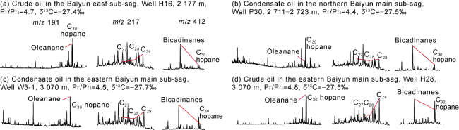
Fig. 2. Biomarkers of Zhujiang Formation crude oils in different zones of the Baiyun Sag. |
In addition, the gas in the gas reservoirs that have been discovered in the Baiyun Sag is mainly wet gas, with the dryness coefficient of 0.88-0.92, and δ13C1 of −44‰ to −35‰ (generally −38‰ to −36‰). Only shallow gas in such wells like Well H19 at the far source end of the northern Baiyun main sub-sag is affected by biogenic gas, resulting in a lighter carbon isotope composition of methane. The distribution of δ13C2 values is relatively concentrated, ranging from −29.6‰ to −27.2‰ (generally −29‰ to −28‰), suggesting a mixed genesis gas between oil type gas and coal type gas. It is indicated that the gas may be derived from shallow lacustrine and delta facies source rocks and originated from kerogen cracking [17-18]. The carbon isotopic composition of ethane in natural gas can effectively reflect the isotopic composition of the source rock. The carbon isotopic compositions of kerogen in the shallow lacustrine mudstone of the Wenchang Formation in Well W3-4 and that in the shallow lacustrine source rock of the Enping Formation in Well H27 are −28.0‰ and −27.7‰, respectively. The carbon isotopic compositions of ethane from mixed genesis gas discovered in the Baiyun Sag exhibit the similar distribution characteristics to the carbon isotope compostions of shallow lacustrine kerogen of the Wenchang Formation and Enping Formation, but significant difference from the carbon isotopic compositions of kerogen in typical semi-deep lacustrine, delta coal measure, and marine-continental transitional mudstone. This also means that the shallow lacustrine source rocks of the Wenchang Formation and Enping Formation are the main source rocks for natural gas in this area.
3. Tectonic-thermal evolution
3.1. Distribution of present geothermal field
The characterization of the present geothermal field in sedimentary basins mainly includes geothermal gradient and heat flow [19]. We focused on studying the present geothermal gradient in the Baiyun Sag. The borehole temperature measurement data is the main source for calculating the geothermal gradient in a basin, which comes from well test temperature, temperature and pressure measurement temperature, and bottom hole temperature. Generally speaking, the well test temperature is the closest to the formation temperature, while the temperatures obtained from bottom hole, temperature measurement, and pressure measurement are affected by the circulation and static duration of drilling fluid, resulting in low temperatures that need to be corrected before using. By using the empirical formula [11], the temperatures obtained from temperature measurement, pressure measurement and bottom hole of 115 exploration wells in the Baiyun Sag were corrected to restore the present formation temperatures of the Sag. The present geothermal gradient in the Baiyun Sag is 3.5-5.2 °C/100 m, showing an overall increasing trend from northwest to southeast, with significant differences among different sub-sags. The geothermal gradient in the Baiyun west sub-sag is the lowest, mainly (3.5±0.2) °C/100 m. The present geothermal gradient in the center of the Baiyun main sub-sag is (4.5±0.2) °C/100 m. The geothermal gradient in the eastern part of the Baiyun main sub-sag is higher, with a value of (5.0±0.2) °C/100 m. The geothermal gradient in the Baiyun south sub-sag is the highest, mainly (5.2±0.2) °C/100 m. The difference in the distribution of geothermal gradient is mainly related to the thinning of the crust thickness from northwest to southeast in the Baiyun Sag.
3.2. Tectonic-thermal evolution history
The tectonic-thermal evolution history of a basin plays an important role in the oil and gas accumulation and the resources evaluation of the basin [20-21]. Previously, various low-temperature thermochronology age dating tests were carried out on drilling basement samples from different areas of the Baiyun Sag, including apatite fission track dating, apatite (U-Th)/He dating, and zircon (U-Th)/He dating. It is determined that the Baiyun Sag exhibited two phases of warming events. Due to the differences in tectonic subsidence and the evolution of basement heat flow in different sub-sags, the time reaching the highest paleo-geothermal was different [22]. The area of Well P27 in the Panyu Low Uplift of the northern Baiyun main sub-sag was in the situation of stable subsidence and continuous burial during the Cenozoic, and currently reaches its highest geothermal temperature. The samples from Well W4 in the eastern Baiyun main sub-sag show three tectonic-thermal events of rapid warming, rapid cooling and slow warming during the Mesozoic-Cenozoic period. Early warming occurred between 13.82-50.00 Ma, reaching the highest paleo-geothermal at 13.82 Ma. The thermal decay since 13.82 Ma has resulted in a slight decrease in geothermal temperature. Well W6 in the southern Baiyun south sub-sag experienced rapid subsidence and burial during the sedimentation of the Wenchang Formation, resulting in a rapid warming of the basement samples from 27.00- 40.00 Ma. It reached its highest paleo-geothermal at 27.00 Ma, and then slowly decreased thereafter.
On the basis of low-temperature thermochronology inversion, a non-instantaneous multi-stage finite extension model was used to perform structural forward modeling on 174 virtual wells in the Baiyun Sag. The results show that the Baiyun Sag has undergone two distinct extension processes since the Cenozoic, which show the trends of high in the west and low in the east, and high in the middle and low at the edge. The extension of the first phase in the Baiyun west sub-sag is stronger than that of the second phase, which is opposite for the Baiyun main sub-sag, the Baiyun east sub-sag and the Baiyun south sub-sag.
The first phase of extension occurred in the Eocene (33.90-47.80 Ma), during which the Baiyun Sag was in a rifting stage. The Baiyun west sub-sag and the Baiyun main sub-sag experienced the strongest extension with an extension index of 1.4-1.7, followed by the Baiyun east sub-sag and the Baiyun south sub-sag with an extension index of 1.1-1.3. The first phase of tectonic extension directly controlled the sedimentary and filling evolution of source rocks in the sag. In the early stage of the rifting, due to the supplement of the western and northern provenances, the activity differences of the sub-sag controlling faults and the northward migration of the subsidence center, the sedimentary center was located on the southwest side of the Baiyun Sag that developed the thickest deposition. In the late stage of the rifting, the subsidence center of the sag was unified to the Baiyun main sub-sag, and the center of the lacustrine basin migrated to the center of the Baiyun main sub-sag due to the differential activity of faults, in which thick source rocks were developed. Overall, the Baiyun main sub-sag has the thickest deposition, followed by the Baiyun west sub-sag, the Baiyun east sub-sag, and the Baiyun south sub-sag.
The second phase of extension occurred in the Miocene (13.82-23.03 Ma), and the strongest extension occurred in the Baiyun main sub-sag with an extension index of 1.9-2.0, followed by the Baiyun south sub-sag with an extension index of 1.6-1.7, and then the Baiyun west sub-sag and the Baiyun east sub-sag with an extension index of 1.2-1.4 [19]. During the second phase of the extension, the sag continued subsiding, and the heat flow of the basement rapidly increased, accelerating the maturation and evolution of the source rocks. The differential distribution of geothermal gradients and two phases of extension control the differential evolution of source rocks in various sub-sags of the Baiyun Sag. The extension model was applied to the basin simulation modeling, and the thermal evolution history of source rocks in the Baiyun Sag were restored with the present-day geothermal field as the verification condition.
4. Simulation of thermal evolution history and hydrocarbon generation history of source rocks
The genetic method with basin modeling as the core is known as the most scientific method of evaluating oil and gas resources due to its consideration of the source and distribution scale of oil and gas. Basin modeling technology was applied to evaluate oil and gas resources of various sub-sags in the Baiyun Sag. Based on the study of parameters such as organic facies, thermal history, and hydrocarbon generation mode, the burial history, hydrocarbon generation and expulsion history of the Baiyun Sag were reconstructed, and the potential of oil and gas resources and favorable exploration zones were predicted.
With the constraint of measured Ro in different sub-sags of the Baiyun Sag, the dynamic model proposed by Sweeney et al. [23] and the Petromod basin simulation software were used to simulate and analyze the thermal evolution history and hydrocarbon generation history of source rocks in the Baiyun Sag.
4.1. Simulation of thermal evolution history of source rocks based on basin modeling technology
Influenced by two thermal events and high geothermal field background, the source rocks in the Baiyun Sag exhibit the characteristics of high geotherm and rapid maturation. As the geothermal gradient increases, the maturity threshold of source rocks becomes shallower rapidly. The hydrocarbon generation threshold was shallowed to 1 300 m, leading to a rapid narrowing of the hydrocarbon generation window (Fig. 3 ). The geothermal gradient of the Baiyun Sag gradually increases from northwest to southeast, and the maturity threshold gradually decreases. Controlled by the differential distribution of geothermal gradients, the thermal evolution degree of source rocks in different sub-sags varies significantly. The Wenchang Formation source rocks in the Baiyun main sub-sag has great burial depths and high geothermal gradients, and the source rocks in the main sub-sag are currently at the high to over mature stage (Fig. 4a ). The burial depth of the Wenchang Formation source rocks is similar in the Baiyun east sub-sag, the Baiyun west sub-sag, and the Baiyun south sub-sag, but the geothermal gradient and maturity of the source rocks in the Baiyun south sub-sag are higher than those in the other twos (Fig. 4a ). The source rock evolution law of the Baiyun south, west and east sub-sags is similar to that of the Baiyun main sub-sag, but the maturity of the source rocks in these three sub-sags is slightly lower than that in the Baiyun main sub-sag (Fig. 4a ). Similar to the maturity characteristics of the Wenchang Formation in the plane, the source rocks of the Enping Formation are generally in the mature to high maturity stage in the Baiyun main sub-sag, but overall in the mature stage in the Baiyun east sub-sag, the Baiyun west sub-sag, and the Baiyun south sub-sag (Fig. 4b ).
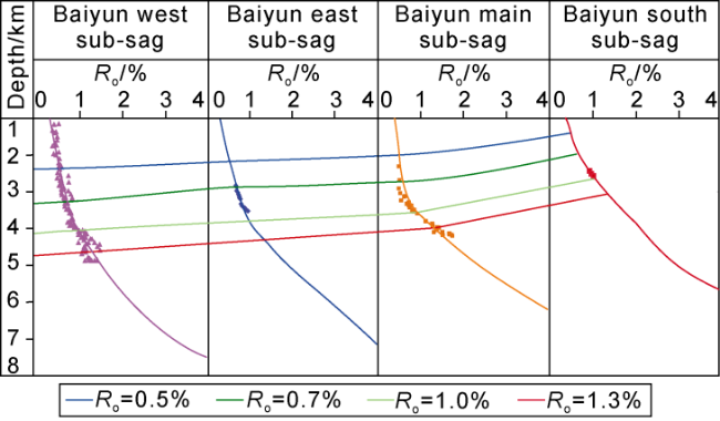
Fig. 3. Ro values evolution with burial depth of source rocks in different sub-sags of the Baiyun Sag. |
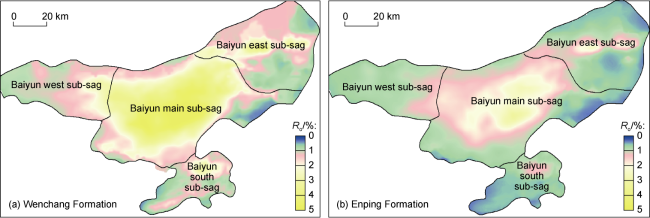
Fig. 4. Prediction of current Ro of source rocks in the Baiyun Sag |
4.2. Reconstruction of hydrocarbon generation history of source rocks
The purpose of hydrocarbon generation history simulation is to reconstruct the hydrocarbon evolution history of source rocks in petroliferous basins. Currently, the methods used to simulate the hydrocarbon generation history of source rocks include volumetric, residual hydrocarbon, rock thermal simulation experiment, material balance, chemical kinetics, and numerical simulation methods [24].
The actual drilling have revealed many types of source rocks in the Paleogene strata of the Baiyun Sag, i.e., semi-deep and deep lacustrine, shallow lacustrine, delta and transitional facies. In order to study hydrocarbon generation characteristics of different types of source rocks in different strata, six Paleogene mudstone samples drilled in the Baiyun Sag and Zhu I Depression (located on the north of Baiyun Sag) were systematically selected for rock thermal simulation experiment using golden tube high temperature and pressure closed system. Due to the current low exploration level and high geothermal gradient, part of mudstone samples is in relatively high maturity (e.g. wells W3-2 and P33), but their Ro is still below 1.1% (Table 2 ). They have not reached the main gas generation stage and still has good representative for the study of gas generation characteristics.
Table 2. Geochemical parameters of mudstone samples from the Baiyun Sag and the Zhu I Depression |
| Well | Depth/ m | Structural location | Formation | Sedimentary facies | Lithology | Pr/Ph | Ro/ % | TOC/ % | HI/ (mg·g−1) | Ratio of kerogen element content | Carbon isotope composition of kerogen/‰ | |
|---|---|---|---|---|---|---|---|---|---|---|---|---|
| H/C | O/C | |||||||||||
| P5 | 3 488- 3 500 | Panyu 4 sub-sag, Zhu I Depression | Wenchang Formation | Semi-deep lacustrine | Mudstone | 2.1 | 0.70 | 5.2 | 534 | 1.47 | 0.08 | −26.3 |
| W3-2 | 4 880- 4 930 | Baiyun main sub-sag | Wenchang Formation | Semi-deep lacustrine | Mudstone | 1.1 | 1.10 | 1.0 | 272 | 1.16 | 0.11 | −28.0 |
| W3-4 | 4 295- 4 335 | Baiyun main sub-sag | Wenchang Formation | Shallow lacustrine | Mudstone | 2.6 | 0.80 | 1.3 | 236 | 1.03 | 0.13 | −28.0 |
| H27 | 4 655- 4 690 | Baiyun east sub-sag | Enping Formation | Shallow lacustrine | Mudstone | 3.6 | 0.99 | 2.7 | 150 | 0.60 | 0.10 | −27.7 |
| P33 | 4 455- 4 480 | Baiyun west sub-sag | Enping Formation | Delta | Mudstone | 5.2 | 1.07 | 1.6 | 144 | 0.46 | 0.06 | −27.0 |
| W3-1 | 3 508- 3 509 | Baiyun east sub-sag | Zhuhai Formation | Marine | Mudstone | 2.4 | 0.60 | 0.9 | 188 | 1.04 | 0.11 | −24.9 |
The semi-deep lacustrine mudstone in Well P5 lying in an algal blooming lacustrine basin has a narrow hydrocarbon generation window and reaches the peak oil generation at Ro of 1.1% with a maximum oil yield of 539 mg/g, the rapid gas generation at Ro of 1.3%-2.0% with maximum gas yield of 520 mg/g, and the upper limit of gas generation at Ro of 2.5%, showing the characteristics of early rapid oil generation and late concentrated gas generation (Fig. 5a ). The semi-deep lacustrine source rock of the Wenchang Formation in Well W3-2 lying in a general nutrient lacustrine basin has a maximum oil yield of only 120 mg/g when the Ro is about 1.1%, which is much lower than the oil yield of Well P5 well in an algal blooming lacustrine basin. The maximum gas yield is only 150 mg/g. Similarly, rapid gas generation occurred at Ro of 1.3%- 2.0%, and then gas generation stopped basically (Fig. 5b ). Similarly, the oil generation characteristics of the Wenchang Formation shallow lacustrine source rocks in Well W3-4 show that this type of mudstone is relatively average in oil generation capability, with a maximum oil yield of 124 mg/g and a wide oil generation window. Particularly in terms of its gas generation characteristics, the gas yield is almost linear, showing the characteristics of continuous gas generation with wide window. It still has good gas generation capacity when Ro is higher than 2.1%, and the gas generation window continues until Ro at 4.0%, with the gas yield of about 220 mg/g (Fig. 5c ). Overall, the shallow lacustrine mudstone of the Wenchang Formation has a good ability to generate kerogen cracking gas with relatively high gas yield and a continuous gas generation window up to Ro of 4.0%. Because of high geothermal setting in the Baiyun Sag, this type of source rock can be an excellent gas source rock with strong generation capacity of kerogen cracking gas, which is consistent with the previous research that the gas in this area is mainly kerogen cracking gas [17-18].
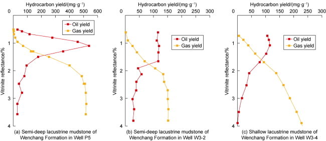
Fig. 5. Simulation of hydrocarbon generation of different types of source rocks in the Baiyun Sag. |
The shallow lacustrine mudstone of the Enping Formation in Well H27 has relatively high maturity (Ro=1.0%), making it difficult to simulate and reconstruct its complete oil generation process. However, its residual oil yield is as high as 150 mg/g at the beginning of the simulation experiment with Ro of 0.8%. It is speculated that the oil yield in the early oil generation window is still considerable. This type of source rock is mainly composed of terrestrial detrital materials. In terms of gas generation characteristics, the shallow lacustrine source rocks of the Enping Formation exhibit the characteristics of continuous gas generation, with a maximum gas yield of about 200 mg/g, which is 1.3 times of the maximum oil yield. The kerogen still has gas generation capacity in the late stage, but its gas production capacity is lower than that of the shallow lacustrine mudstone of the Wenchang Formation revealed in Well W3-4. Compared with the shallow lacustrine mudstone mentioned above, the delta coal measure mudstone of the Enping Formation in Well P33 also has a higher maturity, with Ro reaching 1.1%. The residual oil yield of this type of mudstone suggests its relatively poor oil generation ability, which may be related to its being deposited in a strong oxidative sedimentary environment (Pr/Ph up to 5.6). During the transport process of terrestrial organic matter, hydrogen enriched components would undergo oxidation and humification, resulting in relatively poor oil generation ability. However, this type of hydrocarbon source rocks has extremely strong gas production capacity. On the one hand, the gas yield can reach 220 mg/g, which is 2.4 times of the maximum oil yield, showing a strong ability to generate kerogen cracking gas. On the other hand, this type of source rock can still generate gas rapidly when Ro is greater than 2.1%. At this stage, the crude oil has basically been completely cracked, so the gas is mainly kerogen cracking gas, indicating that the delta coal measure mudstone of the Enping Formation can also serve as good gas source rocks. Similar to semi-deep lacustrine source rocks, marine source rocks mainly generate oil and has moderate capacity of generating kerogen cracking gas, with relatively low gas yield. In summary, the studies on the hydrocarbon generation characteristics of different types of source rocks in Wenchang and Enping Formations demonstrate that the mudstone of transitional and semi-deep lacustrine facies in algal blooming lacustrine basins or general nutrient lacustrine basins mainly generates oil rapidly in a narrow oil window but has relatively poor ability to generate kerogen cracking gas due to the relatively high enrichment of algae. The shallow lacustrine mudstone of the Wenchang Formation and the delta coal measure mudstone of the Enping Formation have moderate oil production capacity with a wide oil generation window, but they have good kerogen cracking gas generation capacity and can generate gas rapidly and sustainably even when Ro is greater than 2.1%. They have relatively high gas yield with a wide gas generation window up to Ro of 4%. The shallow lacustrine mudstone of the Enping Formation has good ability to generate light oil and still has moderate kerogen cracking gas generation ability in the late stage, but its gas yield is relatively lower compared with that of the shallow lacustrine mudstone of the Wenchang Formation and the delta coal measure mudstone of the Enping Formation.
The hydrocarbon generation characteristics of source rocks in different facies belts of the Wenchang Formation and Enping Formation in the Baiyun Sag were restored by means of the rock thermal simulation experiment method. Based on the thermal history simulation, the hydrocarbon generation history of the source rocks was numerically simulated using the basin modeling software and reconstructed quantitatively, and the hydrocarbon generation amounts of source rocks in different layers in different historical periods were calculated. Based on the new understanding of sedimentary facies, combined with the geochemical characteristics and hydrocarbon generation mechanism of drilled source rocks, the hydrocarbon generation in the Baiyun Sag was simulated. The simulation results indicate that due to the influence of tectonic-thermal evolution, high geothermal gradient and differential distribution of geothermal field in the Baiyun Sag, there are significant differences in hydrocarbon generation history and intensity among different sub-sags. Overall, the Baiyun main sub-sag source rocks generated hydrocarbons earlier, with the main oil generation stage occurring before 23.03 Ma and the gas generation stage mainly during 15.97 Ma to 23.03 Ma. The hydrocarbon generation intensity is significantly higher than other sub-sags, with an average of about 1 200×104 t/km2. The main oil generation period of the Baiyun east sub-sag source rocks is from 10.00 Ma to 23.03 Ma, and the main gas generation period is from 15.97 Ma to the present. The main oil generation period of the Baiyun south sub-sag source rocks is from 15.97 Ma to 33.90 Ma, and the gas generation period is concentrated during 15.97 Ma to 23.00 Ma. The main oil generation period of the Baiyun west sub-sag source rocks lasts long, with the main oil generation period occurring during 10.00 Ma to 33.90 Ma, and the gas generation stage from 23.03 Ma to the present.
5. Prediction of oil and gas resource distribution
5.1. Oil and gas resource evaluation
Based on the hydrocarbon generation and expulsion geological model of source rocks, the hydrocarbon expulsion amount of different sequence source rocks in different hydrocarbon generation sub-sags of the Baiyun Sag was investigated. By using oil and gas accumulation coefficients comprehensively, the potential of oil and gas resources in different sequence source rocks of the Baiyun Sag was evaluated, and the main source rocks were identified. The oil and gas resource potential in the Baiyun Sag was calculated by referring to the research results of Zhu et al. [25] on oil and gas accumulation coefficient in different sags of the Pearl River Mouth Basin. When the hydrocarbon supply flow line type of the migration and accumulation unit was convergent flow, the oil accumulation coefficient was 11.59% and the gas accumulation coefficient was 1.5%. When the hydrocarbon supply flow line of the migration and accumulation unit was a parallel flow, the oil accumulation coefficient was 10% and the gas accumulation coefficient was 1.2%.
The evaluation results show that the Baiyun Sag has abundant oil and gas resources, with a total geological resource of about 18×108 t, in which natural gas accounts for about 60%. Controlled by factors such as the quality, type and thermal history of source rocks, oil and gas resources in different sub-sags exhibit differential enrichment characteristics in both horizontal and vertical directions. The Baiyun main sub-sag has developed good shallow lacustrine gas source rocks, which have reached a high maturity to over maturity stage, resulting in abundant gas resources. In the Baiyun east sub-sag, shallow lacustrine source rocks with good ability to generate light oil are developed and their maturity is relatively low, so they are primarily characterized by oil generation. The shallow lacustrine source rocks developed in the Baiyun west sub-sag generate both oil and gas, mainly controlled by the organic matter type and maturity of the source rocks. The Baiyun south sub-sag is characterized by the development of semi-deep lacustrine source rocks, which mainly generate oil. The total geological resources of oil and gas in each sub-sag from the largest to the smallest are as follows: the Baiyun main sub-sag (about 10×108 t), the Baiyun south sub-sag (about 3×10⁸ t), the Baiyun east sub-sag (nearly 3×10⁸ t), and the Baiyun west sub-sag (about 2×10⁸ t). Affected by the distribution scale of source rocks in the Baiyun Sag, the main oil and gas resources are mainly derived from the Wen 3 and Wen 4 members (accounting for about 41% of the total resources), followed by the Wen 2 and Wen 5 members (accounting for about 27% of the total resources). In general, the contribution of the Wenchang Formation source rocks accounts for 74% of the total resources.
5.2. Simulation and evaluation of hydrocarbon migration and accumulation units
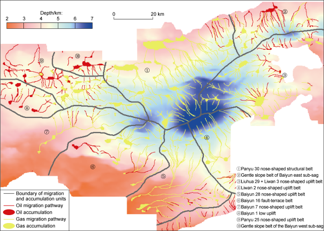
Based on the evaluation of oil and gas resources, the division of migration and accumulation units in the Baiyun Sag was carried out, and the advantageous hydrocarbon migration and accumulation directions were determined. Confined by the segmentation grooves and the farthest boundary of oil and gas migration (such as sub-sag controlling faults, secondary structural zones, etc.), the migration and accumulation unit refers to the entire geological body involving in the hydrocarbon expulsion from source rock to accumulation in reservoirs through migration along transport carriers, including hydrocarbon migration streamline type, streamline direction, fluid potential, and migration and accumulation intensity [26]. The Baiyun Sag is divided into ten migration and accumulation units based on the advantageous hydrocarbon migration direction and the migration and accumulation intensity (Fig. 6 ). Due to the differences in the scale and hydrocarbon expulsion efficiency of effective source rocks, the accumulation intensity of each unit in the Baiyun Sag varies, resulting in differences in the resource potential and accumulation abundance (the amount of oil and gas resources accumulated per unit area of each unit). The accumulation intensity is mainly determined by the dominant direction of oil and gas migration, and is closely related to the magnitude of potential energy changes and the streamline pattern during hydrocarbon migration. The types of migration streamlines can be divided into convergent flow, parallel flow and divergent flow, among which convergent flow is generally the most favorable for oil and gas accumulation. Based on the above factors, a hierarchical and classificatory evaluation of each migration and accumulation unit is conducted, and the favorable enrichment zones in the Baiyun Sag and its surrounding areas are selected (Table 3 ). Class I migration and accumulation unit is mainly composed of convergent flow, with migration and accumulation amount greater than 4.0×10⁸ t and accumulation abundance greater than 25×104 t/km2. Class II migration and accumulation unit is mainly composed of convergent flow or parallel flow, with migration and accumulation amount greater than (0.9-4.0)×108 t and accumulation abundance greater than 12×104 t/km2. Class III migration and accumulation unit is mainly composed of aggregation flow, with migration and accumulation amount less than 0.9×10⁸ t and accumulation abundance less than 12×104 t/km2.
Fig. 6. Overlapping diagram of migration and accumulation unit division and hydrocarbon migration flow potential on Enping Formation top of the Baiyun Sag. |
Table 3. Comprehensive evaluation of each migration and accumulation unit in the Baiyun Sag |
| Unit No. | Favorable zone of migration and accumulation | Type of hydrocarbon supply flow | Convergent area/km2 | Accumulation amount/108 t | Accumulation abundance/ (104 t∙km−2) | Classification |
|---|---|---|---|---|---|---|
| ① | Panyu 30 nose-shaped structural belt | Convergent flow | 2 114 | 5.340 0 | 25.26 | I |
| ② | Gentle slope belt of Baiyun east sub-sag | Convergent flow | 808 | 1.510 0 | 18.69 | II |
| ③ | Liuhua 29 + Liwan 3 nose-shaped uplift belt | Convergent flow | 1 948 | 4.910 0 | 25.21 | I |
| ④ | Liwan 2 nose-shaped uplift belt | Parallel flow | 962 | 0.432 0 | 4.49 | III |
| ⑤ | Baiyun 28 nose-shaped uplift belt | Convergent flow | 2 371 | 1.120 0 | 4.72 | III |
| ⑥ | Baiyun 16 fault-terrace belt | Parallel flow | 750 | 0.571 0 | 7.61 | III |
| ⑦ | Baiyun 7 nose-shaped uplift belt | Convergent flow | 682 | 0.335 1 | 4.91 | III |
| ⑧ | Baiyun 1 low uplift | Parallel flow | 765 | 0.927 2 | 12.12 | II |
| ⑨ | Panyu 25 nose-shaped uplift belt | Convergent flow | 1 246 | 0.536 4 | 4.30 | III |
| ⑩ | Gentle slope belt of the Baiyun west sub-sag | Parallel flow | 409 | 0.113 9 | 2.79 | III |
The Panyu 30 nose-shaped structural belt (No. ①) and the Liuhua 29 + Liwan 3 nose-shaped uplift belt (No. ③) in the Baiyun Sag are the advantageous directions of oil and gas migration in the Baiyun main sub-sag. Oil and gas are charged in the form of convergent flow, and the segmentation groove cuts the main source rocks in the Baiyun main sub-sag. The total geological resources amount of oil and gas in the No. ① unit is 4.05×10⁸ t, and that in the No. ③ unit is 4.91×10⁸ t, with an oil and gas accumulation abundance greater than 25×104 t/km2. According to the evaluation criteria, the No. ① unit and No. ③ unit are included in the category of Class I migration and accumulation unit.
The gentle slope belt of Baiyun east sub-sag (No. ②) and the Baiyun 1 Low Uplift (No. ⑧) are relatively favorable migration and accumulation units, as well as the advantageous directions of oil and gas migration. The segmentation grooves of these units cut the main source rocks of each sub-sag in the Baiyun Sag. The oil and gas charging forms include convergent flow and parallel flow. According to the indicators of area, accumulation amount, and accumulation abundance of hydrocarbon source rocks, these units are included in the category of Class II migration and accumulation unit. In the other units, the main source rocks have not been cut by the segmentation grooves, and the oil and gas are charged in the form of parallel flow. These units are categorized as Class III migration and accumulation units. To sum up, the favorable enrichment zones in the Baiyun Sag are the Panyu 30 nose-shaped structural belt (No. ①), the Liuhua 29 + Liwan 3 nose- shaped uplift belt (No. ③), the gentle slope belt of Baiyun east sub-sag (No. ②) and the Baiyun 1 Low Uplift (No. ⑧).
6. Conclusions
There are significant differences in the sedimentary environment and organic matter composition of different types of hydrocarbon source rocks in the Paleogene Eocene of the Baiyun Sag. The semi-deep lacustrine source rocks of the Wenchang Formation were deposited in a relatively reducing environment, with algae as the main organic matter composition and mainly generating oil. The shallow lacustrine source rocks of the Wenchang Formation and Enping Formation were deposited in weakly oxidizing environments, with terrestrial higher plants as the main organic matter composition and moderate contributions from algae, leading to the generation of both oil and gas. The delta coal measure source rocks of the Enping Formation were deposited in an oxidative environment, with terrestrial higher plants as the main organic matter composition, and they are categorized as humic type source rock. The marine-continental transitional source rocks of the Enping Formation exhibit a mixed composition of terrestrial higher plants and marine algae, with the ability of generating both oil and gas. The gas and oil discovered in the Baiyun Sag exhibit the characteristics of shallow lacustrine origin, and have a good affinity relationship with the shallow lacustrine source rocks of the Wenchang Formation and Enping Formation. Considering the scale of the source rocks, it can be clarified that shallow lacustrine source rocks are the main source rocks in the Baiyun Sag.
Affected by the thinning of the crust, the current geothermal gradient of the Baiyun Sag shows an increasing trend from northwest to southeast. The geothermal gradient of different sub-sags is quite different and mainly distributed in the range of (3.5-5.2)°C/100 m. The comprehensive research results of low-temperature thermochronology inversion and tectonic-thermal evolution history forward modeling reveal that the Baiyun Sag has experienced two obvious extensional processes since the Cenozoic. The first stage of tectonic extension occurred at 33.90-47.80 Ma and the second stage of extension occurred at 13.82-23.03 Ma. The whole sag subsided continuously and the basement heat flow rose rapidly during the extension periods. The two stages of extension caused two rapid warming events and heat flow reached the highest value at 13.82 Ma, which accelerated the maturation and evolution of source rocks.
The differences in geothermal setting, source rock characteristics and burial depth cause the significant difference in thermal evolution degree and hydrocarbon generation characteristics of source rocks in different sub-sags. Compared with the other sub-sags, the Baiyun main sub-sag is obviously higher in maturity and generates hydrocarbon earlier. The widely distributed shallow lacustrine mudstone of the Wenchang Formation and the delta coal measure mudstone of the Enping Formation have a wide oil generation window but moderate oil generation capacity. However, they have good capacity of generating kerogen cracking gas and relatively high gas yield with wide gas generation window. The shallow lacustrine mudstone of the Enping Formation has good ability to generate light oil, and it still has moderate ability to generate kerogen cracking gas in the late stage, but it is not as good as the shallow lacustrine mudstone of the Wenchang Formation and the delta coal measure mudstone of the Enping Formation. The semi-deep lacustrine and marine-continental transitional mudstones are rich in algae, characterized by centralized and rapid oil generation with a high oil yield but poor ability to generate kerogen cracking gas.
The resource evaluation results show that the sag is rich in oil and gas resources, with the total geological resources of about 18×108 t, in which gas resources account for about 60%. Most of the resources are distributed in the Baiyun main sub-sag, and the Wen 3 and Wen 4 Members are the main source rocks. Through the division and evaluation, four favorable migration and accumulation units are selected: the Panyu 30 nose-shaped structural belt (No. ①), the Liuhua 29 + Liwan 3 nose- shaped uplift belt (No. ③), the gentle slope belt of Baiyun east sub-sag (No. ②) and the Baiyun 1 Low Uplift (No. ⑧).