

Introduction
With more drilling and research efforts to the Lower Paleozoic in the Ordos Basin, many studies have been carried out on the tectonics and lithofacies paleogeography of the Lower Paleozoic carbonate series, covering the formation and evolution of multiple orders of tectonic units [1⇓⇓⇓⇓⇓-7], key tectonic changes and unconformities [8⇓-10], sedimentary differentiation and filling characteristics under the coupling control of tectonic-geomorphic units and sea level fluctuation [3,11 -12]. Especially, the discovery of the Wushen Banner-Jingbian paleo-uplift broke through the traditional understanding of the paleogeography [13-14], and provided a new idea for the exploration of the Ordovician sub-salt and Cambrian formations [5,15].
The formation and evolution of the tectonic pattern in the Ordos Basin often depend on the tectonic background of the surrounding plates, and the evolution law may have a profound impact on the distribution of source rocks and reservoirs, as well as hydrocarbon accumulation in the uplift area and its periphery [16]. Regarding the characterization and evolution of the paleo-uplift, previous studies focused on seismic sections and stratigraphic contacts [4,6 -7], and the lithofacies and paleogeography after the Cambrian [5] or the third member of the Ordovician Majiagou Formation (O1m3 for short) [3]. In contrast, due to the lack of drilling data from the Cambrian and the complex unconformity between the upper and lower formations, it is difficult to understand the bottom and lower layers of the Majiagou Formation from well logging data. As a result, few sedimentological researches were carried out on the early sediment filling process of the Majiagou Formation, the sedimentary responses of different tectonic units, and the restoration of lithofacies and paleogeography. Moreover, considering that the Majiagou Formation directly contacts the tectonic unconformity caused by the Huaiyuan Movement in most part of the Ordos Basin, it is of great significance for studying the continuity of evolution of the Cambrian-Ordovician successive uplift and even the whole tectonic-lithofacies paleogeographic pattern.
Based on the logging data from 104 wells that penetrate the first to third members of the Ordovician Majiagou Formation (O1m1-O1m3 for short) and the core data from more than 20 wells, and considering geochemical analysis, this study analyzed the stratigraphic markers and the filling process of the overlying strata on the tectonic unconformity caused by the Huaiyuan Movement, reconstructed the tectonic-lithofacies paleogeographic pattern of the Upper Majiagou Formation, investigated the evolution and sedimentary differentiation effects of all tectonic units and their oil and gas geological significance, with the intent to provide theoretical supports for all-round exploration of the successive uplift.
1. Geologic background
Located on the western margin of the North China craton, and influenced by the activities of surrounding plates [17], the Ordos Basin has undergone multiple critical tectonic changes that caused several regional unconformities [8]. Among them, the tectonic unconformity associated with the Huaiyuan Movement before the deposition of the Majiagou Formation is the product of episodic tectonic movement of the Caledonian Movement. It is a parallel unconformity between the Liangjiashan Formation and the Majiagou Formation in the whole North China Plate [18], but an angular unconformity formed by multiple superimposed tectonic movements in the Ordos Basin [9-10] (Fig. 1a , 1b ).
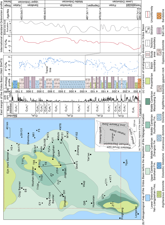
During the Huaiyuan Movement, the strata beneath the unconformity were exposed in a complex manner and a large time span. The Majiagou Formation was in unconformable contact with the Precambrian and the Middle-Upper Cambrian strata (Fig. 1b ). Especially, the Cambrian erosion in the Wushen Banner-Jingbian region is severe, and the bottom Cambrian gradually overlaps on the Precambrian, which explains the existence of the Cambrian Wushen Banner-Jingbian paleo-uplift [3]. In addition, based on the truncation of the top Cambrian toward the paleo-uplift core, it is concluded that the uplift was a successive tectonic uplift during the Cambrian-Ordovician [5,7]. Jointly controlled by the Central Uplift zone and sea level fluctuation [3], the lithological combination of the Majiagou Formation shows obvious cycles [15]. O1m1 and O1m3 are dominated by evaporite rock, and O1m2 is mainly composed of carbonate rock (Fig. 2 ).
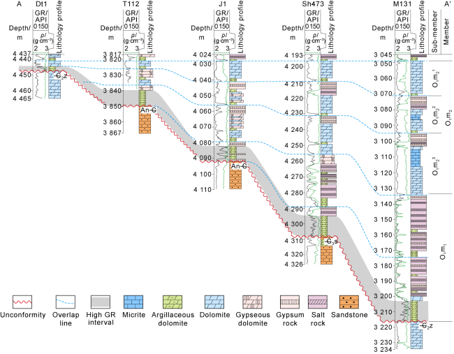
Fig. 2. Stratigraphic contact relationship of the middle-eastern Ordos Basin (see section location in |
2. Stratigraphic filling and paleotectonic-geomorphology
Taking the whole-coring well Sh473 as standard, the strata revealed by exploration wells drilled in O1m1 -O1m3 in the study area were divided, and systematic analysis of C and O stable isotopic compositions was carried out in the Carbonate Sedimentary-Diagenetic Geochemistry Laboratory of Southwest Petroleum University. A δ13C profile of O1m1 -O3m5 was established (Fig. 1c ).
2.1. Stratigraphic division and correlation
At the bottom of the Majiagou Formation in Well Sh473 (Fig. 1c ), there is an argillaceous dolomite interval with high gamma ray (GR) values, which is in unconformable contact with the underlying sandstone. The middle and upper parts of O1m1 quickly transit into gypsum-salt rock. In O1m2, thick evaporite rock disappears, and a three- segment rock- electric cycles exhibit with three dolomite intervals sandwiching two gypsum intervals, and three low GRs sandwiching two high GRs in the vertical direction [19]. The Majiagou Formation is divided into three sub- members from bottom to top (O1m23, O1m22, and O1m21). The GR curve of O1m3 fluctuates significantly. It is the most important saliferous interval in the lower combination. In it, the lower O1m33 has high GR values; the middle O1m32 has alternative high and low GR values, representing major salt layers; the upper O1m31 shows a GR curve that first increases and then decreases. Then salt rock disappears throughout the basin, and instead dolomite- gypsum sediments begin. However, in the whole-coring well Sh473, the δ13C profile shows that the δ13C values of O1m1 to O1m3 show a positive shift by about 4‰, while the δ13C values of O2m4 remain stable at around 0. Compared with the international standard profile (Fig. 1c ) [20], it is concluded that O1m1 -O1m3 roughly correspond to the Lower Ordovician Floian, which is consistent with the understanding obtained by previous studies on biological- isotope stratigraphic correlation in outcrops around the Ordos Basin [14].
Comparison between east and west margins. Due to the influence of sedimentary differentiation in the Central Uplift, there has long been controversy over the stratigraphic comparison between the east and the west margins. However, present understanding that the bottom of the Majiagou Formation can be compared with the bottom of the Ordovician Sandaokan Formation on the west margin has been unified [9,14]. Data show that the Sandaokan Formation is mostly composed of diamictic tidal flat sediments from terrestrial input [21], and has high GR values, similar to the bottom of the Majiagou Formation represented by Well Sh473 (Fig. 1c ).
Comparison in the basin: In the whole-coring wells T112 and Sh473, argillaceous dolomite at the bottom of the Majiagou Formation is in unconformable contact with the underlying sandstone, and exhibits the sedimentary characteristics of marginal facies [5]. Further regional comparison reveals that the high-GR interval corresponding to the bottom argillaceous dolomite exists stably throughout the basin and can serve as a marker bed for the bottom of the Majiagou Formation (Fig. 2 ). Lateral comparison of the rock-electric cycles found that: (1) The lithological combinations in the whole-coring wells are different. The argillaceous dolomite at the bottom of Well Sh473 rapidly transits upwards to thick salt rock, which belongs to the typical characteristics of the O1m1 Member [2]. However, at the bottom of Well T112, the lithological cycle that argillaceous dolomite transits upwards to be dolomite-gypsum interbedded with argillaceous dolomite exhibits typical three-stage characteristics of the O1m2 Member. It's believed that the argillaceous dolomite at the bottom of the Majiagou Formation is distributed in a diachronous style. (2) The number of cycles gradually decreases and the thickness decreases from east to west, indicating the development of overlapping sediments above the unconformity. The O1m1 Member first overlaps between Well Sh473 and Well J1, and then the sedimentary boundary gradually expands between Well J1 and Well T112. The O1m2 Member continues to overlap westward to the vicinity of Well DT1, and reaches its maximum sedimentary range by O1m21 (Fig. 2 ).
2.2. Stratigraphic filling characteristics
According to the stratigraphic division standards, for-mations in all wells were divided, and the thickness maps of O1m1 to O1m3 and their sub-members were prepared (Fig. 3 ).

Fig. 3. Thickness maps of O1m1-O1m3 in the Ordos Basin. |
The O1m1 is only distributed in the central and eastern regions, and becomes thicker and thicker toward the Shenmu-Mizhi-Zichang-Yichuan region in a ring style, until to the maximum 140 m, but missing in the Otog Banner-Dingbian-Qingyang region in the west (Fig. 3a ).
The O1m2 Member began to appear east-west differentiation: thinner in the Otog Banner-Dingbian-Huanxian region (generally less than 20 m), thicker westward to nearly 60 m, and successive ring distribution from O1m1 in the east, up to 110 m thick in the Shenmu-Mizhi- Zichang region (Fig. 3b ). Moreover, the sedimentary range gradually expanded to the Otog Banner-Dingbian- Huanxian region from absent to thin sediments, and only leaving northern Otog Banner and Qingyang without O1m2 (Fig. 3d -3f ).
Following O1m2, O1m3 shows two thicker zones in the east of the study area. O1m3 near Well CC1 in the west is nearly 160 m thick, and 200 m thick in the Shenmu- Mizhi-Zichang region in the east, but thin (80-120 m) in the Wushen Banner-Jingbian region (Fig. 3c ). The early and middle sedimentation of O1m3 was successive (Fig. 3g , 3h ), but the thinner zones in the Otog Banner-Dingbian- Huanxian region began to shrank in the SN direction when O1m31 deposited, while the thicker zones merged and expanded around Well CC1 and its west (Fig. 3i ).
2.3. Restoration of geomorphology
The restoration of original sedimentary geomorphology has always been a key and difficult point in the study of carbonate sedimentation and reservoirs [2]. The distribution of stratigraphic thickness is the result of sedimentary filling under geomorphic control. In the study area, the stratigraphic pinch-out margin zone often represents the transitional margin facies zone [5]; the thinner zone reflects the insufficient accommodation of under-water highlands and it is an important basis for identifying paleo-uplifts [4]; the thicker zone mainly develops evaporite rock [3]. Considering the genetic characteristics of drying and shrinking, the depocenter reflects the subsidence center [22], and represents the depression area. In addition, the sedimentation rate of gypsum-salt rock is fast, and far higher than the subsidence rate of platform [23]. After sedimentation stops, the accommodation space would be nearly filled and leveled. Taking the top of gypsum-salt rock as a datum, we restored the original tectonic-geomorphic pattern using the impression method (Fig. 4 ).
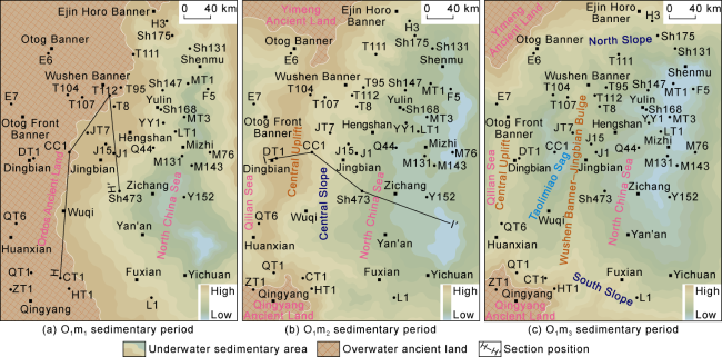
Fig. 4. Schematic maps of tectonic-geomorphology of O1m1-O1m3 in the Ordos Basin. |
Sedimentation of O1m1. During the sedimentation of O1m1, sea and land were evenly distributed in the study area, and the Central Uplift which was an overwater uplift was on the Ordos Ancient Land [1]. Eastward, the uplift transited to a depression, water became deep, and the Central Slope transited to the East Depression (Fig. 4a ).
Sedimentation of O1m2. From the perspective of bottom overlap (Fig. 2 ) or continuous expansion of the sedimentary range (Fig. 3a , 3b ), marine ingression kept going when O1m1 and O1m2 deposited. The Ordos Ancient Land was inundated, and the tectonic pattern of alternating uplifts and depressions in the Ordovician began to take shape. The body of the Ordos Ancient Land was submerged and shrunk into two ancient lands (the southern Qingyang Ancient Land and the northern Yimeng Ancient Land) which were connected via the saddle of the Central Uplift as an underwater highland. The east part still included the Central Slope and the East Depression, while the west covered the West Edge Depression (Fig. 4b ).
Sedimentation of O1m3. The tectonic pattern of alternating uplifts and depressions was further differentiated, and distributed as stripes in the south-north direction. The Central Uplift migrated westward. The East Depression was decomposed into two secondary tectonic units (the Wushenqi-Jingbian Bulge and the Taolimiao Sag). The southern and the northern slopes transited to ancient lands (Fig. 4c )
From the perspective of tectonic-geomorphologic evolution, the Central Uplift was an onshore uplift before the sedimentation of O1m2, but it was submerged when global marine ingression happened (Fig. 2 ). A large pattern with one uplift and two depressions appeared in the study area. Previous researchers believed that the Wushen Banner-Jingbian Bulge was developed during the Cambrian [3,5,7], but this study suggests that there was no significant response before the deposition of O1m3, and it merged with the Central Uplift (Fig. 4a , 4b ).
Since the sedimentation of O1m3, the tectonic pattern of uplift and depressions was further refined, and the Wushen Banner-Jingbian Bulge appeared. The whole pattern was in SN distribution. In combination with the relationship between the peripheral plates during the Early Ordovician Floian period [24], it is considered that its formation is related to the collision and compression of the western plate boundaries. The Caledonian Movement at the west margin exhibited episodic activities [25]. The first episode occurred during the Middle-Late Cambrian when the Qilian oceanic crust began to subduct. The second episode occurred during the Early-Middle Ordovician, represented by subduction, collision and merging of the Qilian Block-Alashan Block and the North China Plate outside the basin. The latest data has confirmed the North Qilian Block experienced early subduction initiation, island arc maturation, subduction accretion and tectonic exhumation before 455 Ma to 492/488 Ma [26]. The analysis of collision and its corresponding time shows that the extrabasinal plate movement applied a force driving intrabasinal tectonic-geomorphic evolution, induced the first Ordovician tectonic activation during the sedimentary period of the O1m3 Member, and started the development of the Wushen Banner-Jingbian Bulge again.
In general, the tectonic-geomorphologic evolution law featured by "the rise of global sea level, the submergement of ancient lands; the subduction and extrusion of extrabasinal plates, and the differentiated uplift and depression inside the basin" can explain the evolution process of the important tectonic units (such as the Central Uplift and the Wushen Banner-Jingbian Bulge) in the early sedimentary period of the Majiagou Formation.
3. Lithofacies paleogeography and tectonic-sedimentary differentiation
3.1. Types and characteristics of typical sedimentary facies
Based on the identification of facies markers in drilling and coring data, sedimentary facies were analyzed. It is concluded that the O1m1-O1m3 members in the Ordos Basin are generally restricted evaporite platform facies which can be subdivided into six subfacies.
Muddy-dolomitic flat: The extremely shallow water environment influenced by tidal action and around ancient land [13] was the marginal zone of transitional facies [5]. Due to the influence of terrestrial inputs, muddy/sandy dolomite and lamellar micritic dolomite are common. For instance, diamictite rocks are well developed at the bottom of the Majiagou Formation (Fig. 5a ). They often exhibit normal grading in cores, and there are scoured surfaces at the bottom of some diamictite rocks (Fig. 5b ). Upwards, argillaceous dolomite is often accompanied by gypsum lumps of sabkha origin [27] (Fig. 5a ).

Fig. 5. Sedimentary facies types and petrological characteristics of O1m1-O1m3 (arrows point upward). (a) Muddy-dolomitic flat at the bottom of the Majiagou Formation; normal grading; gypsum lumps at the top; O1m1; 4 302.03 m; Well Sh473; (b) muddy-dolomitic flat with scoured surfaces at the bottom, and filled with quartz particles; argillaceous dolomite upward; normal grading; O1m32; 4 205.85 m; Well T104; single polarized light and orthogonal light; (c) pebbled dolarenite with intergranular pores; grain beach; O1m31; 3 210.46 m; Well Sh168; single polarized light; (d) oolitic dolomite with intergranular dissolved pores; grain beach; O1m22; 4 048.67 m; Well J1; single polarized light; (e) bioclastic dolomite with dissolved pores; grain beach; reverse grading; O1m22; 3 410.40 m; Well Sh168; (f) dolomite micrite; calcareous semi-confined lagoon; O1m23; 3 311.42 m; Well MT3; single polarized light; (g) micritic limy dolomite with biological burrows; dolomite confined lagoon; O1m23; 3 408.10 m; Well YY1; (h) micritic dolomite with gypsum moldic pores; dolomite confined lagoon; O1m21; 3 398.54 m; Well YY1; (i) blocky gypsum rock with a network structure; dolomitic-gypseous evaporite lagoon; O1m31; 3 052.02 m; Well MT3; (j) interbedded gypseous rock and salt rock; O1m1; salty evaporite lagoon; 3 026.38 m; Well M76. |
Grain beach: In the high-energy environment above the wave base, grain beaches were developed, including psammitic beach, oolitic beach, and bioclastic beach according to the grain composition (Fig. 5c -5e ). The typical facies marker is the frequent development of sparry cemented grainstone with reverse grading (Fig. 5e ). In a carbonate platform, grain beaches often appear in high-energy zones such as windward highlands, slope fronts, and deep and shallow slope break zones [28].
Calcareous semi-confined lagoon. It is a sedimentary environment with deep water, low energy and normal salinity. Micritic limestone and a small amount of dolomitic micrite with burrows are found (Fig. 5f ). Limestone is less developed in the study area, and the rock type can be taken as a typical subfacies marker.
Dolomitic confined lagoon. Compared with calcareous semi-confined lagoon, the water energy of dolomitic confined lagoon is low and confined under the influence of surrounding high terrains, so micritic dolomite with horizontally tubular biological burrows (Fig. 5g ), or micritic dolomite with evaporative minerals and abnormal salinity (Fig. 5h ) are developed.
Dolomitic-gypseous evaporative lagoon. As water evaporites, lamellar dolomitic-gypseous rhythmic interlayers appear in the early stage, and then blocky gypsum rock network forms with tidal flats in the later stage [29] (Fig. 5i ).
Salty evaporative lagoon. As more water evaporates and the salinity increases, halite crystallizes and precipitates (Fig. 5j ). Salt lakes often form after the end of water evaporation. As the sedimentary range shrinks, salty lagoons and dolomitic-gypseous evaporative lagoons are distributed as circular stripes [30]. From the perspective of chemical sedimentary differentiation, the four types of lagoon subfacies in the O1m1-O1m3 members evolved from confined to evaporative as water was confined, shown by shallowing water and increasing salinity.
3.2. Well-tie sedimentary facies
Based on well logging data and single-well facies analysis, a WE sedimentary profile was established (Fig. 6 ).
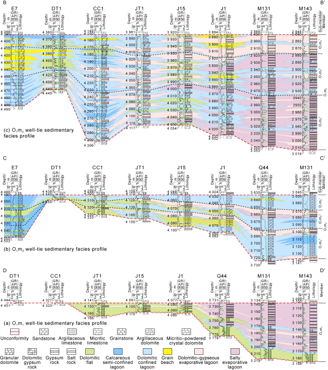
Fig. 6. Well-tie sedimentary facies profile of O1m1-O1m3 in the Ordos Basin (see the section position in |
Sedimentation of O1m1. Deep study on the tectonic unconformity caused by the Huaiyuan Movement and the identification of the overlap at the bottom of the Majiagou Formation on seismic sections [7,19] found the high-GR interval stably developed at the bottom represents a tidal flat/coastal environment, and diachronous distribution on the well-tie profile (Fig. 2 ). This is consistent with the background of global marine ingression during the early Ordovician Floian period (Fig. 2 ) [20]. As water gradually overlapped from east to west, the thick zones became salty evaporative lagoons, and the thin zones became muddy-dolomitic flat subfacies in the east, while the west was ancient land without accepting deposits (Fig. 6a ).
Sedimentation of O1m2. According to the high-GR interval at the bottom of the Majiagou Formation in Wells DT1 and CC1 (Fig. 6b ), marine ingression continued until the sedimentation of the O1m2 Member, making muddy- dolomitic flats (margin facies) mainly distributed in the overlapping area (Fig. 3d -3f ). The sedimentary facies in the thicker zones on two sides became lagoons, calcareous semi-confined lagoon in the west, and three sedimentary cycles of calcareous and dolomitic confined lagoons and gypseous and salty evaporative lagoons in the east. In addition, the transition zone from thick to thin among wells, such as J15 and J1, is grain beach (Fig. 6b ).
Sedimentation of O1m3. The symbiotic system of carbonate rock and evaporite rock is extremely sensitive to the salinity of sedimentary water [29], so the O1m3 Member is almost interbedded sedimentation (Fig. 6c ). Horizontally, sealed by the muddy-dolomitic flat in the thinner zone around wells DT1 and J15, the subfacies changes from calcareous semi-confined lagoon, dolomitic confined lagoon, dolomitic-gypseous evaporative lagoon, to salty evaporative lagoon from west to east. Grain beach facies is around the periphery of the muddy-dolomitic flat subfacies; salty evaporative lagoon subfacies disappears at O1m31; and dolomitic-gypseous evaporative lagoon subfacies shrinks towards the east. This feature is very similar to the sedimentation of the upper O3m56 [11].
3.3. Distribution and evolution of lithofacies paleogeography
Based on the thickness maps, core and logging facies, and the distribution of dolomite, gypsum rock and salt rock, the lithofacies paleogeographic maps of O1m1 - O1m3 were compiled (Fig. 7 ).
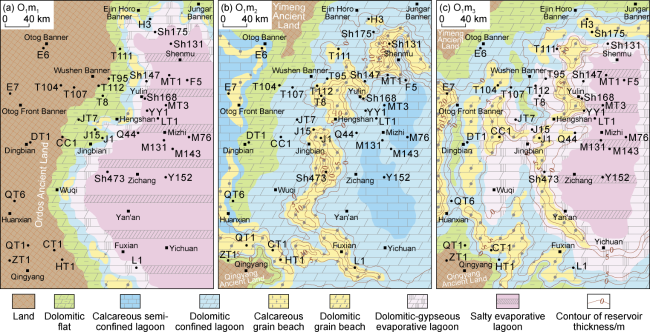
Fig. 7. Lithofacies paleogeographic maps of O1m1-O1m3 in the Ordos Basin. |
O1m1: Lithofacies paleogeography is related to the relative height of geomorphology, and the sedimentary facies belts are distributed in circular stripes. The eastern thicker zones are dolomitic-gypseous and salty evaporative lagoon subfacies, and the west zones around the ancient land are muddy-dolomitic flat subfacies. A few small grain beaches are sporadically distributed and parallel to the coastline (Fig. 7a ).
O1m2: The ancient lands in the northwest and southwest control the development of the muddy-dolomitic flat subfacies around the lands, connect the thinner zones in the Otog Banner-Huanxian region (Fig. 7b ), and separate the western calcareous semi-confined lagoon subfacies from the eastern dolomitic confined lagoon subfacies. Grain beaches are distributed in the transition zone from dolomitic flats to lagoons. The C-shaped beach belt in the Shenmu-Hengshan-Fuxian region is the largest, with some calcareous semi-confined lagoon facies in the east (Fig. 7b ).
O1m3: Large-scale evaporative lagoons are common. However, compared to the O1m1 Member, salty evaporative lagoon subfacies shrank, while dolomitic-gypseous evaporative lagoon subfacies expanded westward, which is consistent with the well-tie profile. The dolomitic-gypseous evaporative lagoon subfacies in the thicker zones around wells CC1 and JT1 is more abundant than that in the thinner zones in the Wushen Banner-Jingbian region (Fig. 6c ). Therefore, from the perspective of the symbiotic system of carbonate rock and gypsum-salt rock, the lithofacies paleogeography of the O1m3 Member is divided into two facies zones: western dolomitic-gypseous lagoons and eastern salty lagoons, by taking the thinner zone in the Wushen Banner-Jingbian region as a boundary (Fig. 7c ). Muddy-dolomitic flat subfacies is mainly distributed in the outer periphery of ancient lands in the northwest and southwest. Grain beach subfacies is around dolomitic-gypseous evaporite lagoons, and they are small in the central and eastern zones.
3.4. Tectonic-sedimentary differentiation and carbonate-evaporite filling model
The O1m1 Member is almost evaporite rock, especially salt rock of over 70 m thick in some wells (Fig. 6a ). Previous researchers concluded the origin of the Majiagou Formation was marine regression according to rhythmic sea level fluctuation. Based on the overlapping background and paleogeographic pattern (Fig. 8a-1 , 8b-1 ), this study proposes a model of marine ingression and isolation taking place during the sedimentary period of the O1m1 Member. The East Depression was isolated by peripheral uplifts and poorly connected with the surrounding open sea, especially completely disconnected with the western Qilian Sea. Marine ingression caused seawater to flood in, but the isolators almost blocked water supply, making the evaporating rate exceed the supply rate, and ultimately the development of large-scale salty evaporative lagoons (Fig. 8a-2 ), which is similar to the salt formation style of inland lakes [31].
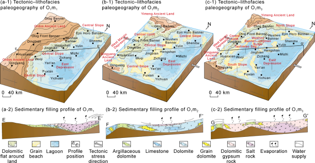
Fig. 8. Tectonic-lithofacies paleogeography and sedimentary filling model of O1m1-O1m3 in the Ordos Basin. |
Large-scale development of carbonate rock during the sedimentary period of the O1m2 Member means that continuous marine ingression reduced water restriction. To the middle-late stage, the North China Sea connected to the Qilian Sea (Fig. 3e , 3f ) by the saddle of the Central Uplift acting as an underwater highland and received marginal deposits, indicating the start of sedimentation of the Central Uplift during the Ordovician period (Fig. 7b ). The sediments on both sides of the uplift were different, namely, limestone on the west side and dolomite with less limestone as lens on the east side. In addition, a small amount of layered gypsum-salt rock deposited with the evaporation, concentration and shrinkage of sedimentary water toward the Eastern Depression into small evaporative lagoons in the late stage (Figs. 6b and 8b-2 ). This model is called a late highstand drying, shrinkage and salt development model.
Plate collisions at the western margin resulted in the differentiated tectonic pattern with uplifts and depressions when the O1m3 Member deposited (Fig. 8c-1 ), and at the same time evaporite rock deposited on a large scale once again, indicating an extremely close coupling and distribution relationship (Fig. 6c ). The Central Uplift, as an underwater highland or intermittent ancient land, was the first isolator that blocked water in the Qilian Sea on the west side, causing confined and evaporative platform facies on the east side of the uplift. The Wushen Banner-Jingbian Bulge, an underwater highland throughout from north to south, was the second isolator causing differential distribution, namely, dolomitic-gypseous rock on the west side and gypseous-salt rock on the east side. Moreover, the sedimentary range of salt rock in all salt-bearing strata of the Majiagou Formation was limited in the East Depression by the Central Uplift [3,11 -12]. Compared with the O1m1 Member or the traditional cow's eye model [30], the development scale of gypsum rock in the O1m3 Member is significantly larger, and much larger than the production of gypsum/halite under natural seawater evaporation. Therefore, it is concluded that the gradual differentiation of seawater by the highland topography led to the fluctuation of water salinity around the gypsum precipitation threshold in the hydrological cycle of evaporation-recharge in the Taolimiao Sag. In the more confined East Depression, the evaporation rate kept exceeding the supply rate until the precipitation of salt rock. This gradual differentiation (Fig. 8c-2 ) is similar to the eccentric multi-stage differentiation law of carbonate-gypsum-salt rocks in the O3m56 Sub-member [11], and it is also a key sedimentary signal for the first tectonic activation of the Wushen Banner-Jingbian Bulge during the Ordovician period. To the upper part of the O1m3 Member, the uplift-depression pattern became weak and less differentiation of stratigraphic thickness (Fig. 3i ), and at the same time, salt rock disappeared and the scale of evaporite rock decreased (Fig. 5c ).
4. Petroleum geological significance
Affected by the Caledonian Movement, a regional tectonic unconformity appeared in the Ordos Basin during the Huaiyuan Movement. An interval of diachronous potential source rock of the Majiagou Formation overlapped on it. During the Early Caledonian, uplift and depression differentiation occurred, and palaeogeomorphology controlled the distribution of beach reservoirs, forming a good source-reservoir configuration, which is expected to be a favorable exploration target in the inheriting uplift zone.
4.1. Diachronous and overlapping potential source rocks above the unconformity
As one of the key hydrocarbon accumulation factors that constrain the exploration of the Lower Paleozoic carbonate rock [16], the potential source rocks in the Majiagou Formation have been evaluated in recent years [15,32⇓⇓ -35]. The transition from early lateral hydrocarbon supply to self-generation and self-storage hydrocarbon accumulation model suggests that the effective subsalt source rocks in the Majiagou Formation are distributed around the gypsum-salt low-lying land on plane [15], and vertically millimeter-sized dark argillaceous dolomite accumulated [33], with small layer scales and disperse distribution.
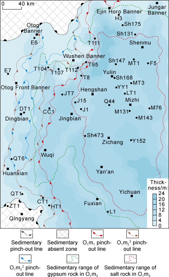
Based on the whole-basin distribution of the margin facies with high GR values at the bottom of the Majiagou Formation revealed by the overlapping sedimentary model, this study discovered a set of stable and diachronous layered source rock above the unconformity. The TOC from O1m1 to O1m3 gradually decreases (Fig. 9 ), and there are several organic-rich intervals at the bottom of the Majiagou Formation. Among them, the overlapping lamellar argillaceous dolomite with TOC higher than 0.3% is effective carbonate source rock [32]. Some scholars confirmed that the same type of lamellar argillaceous dolomite is a high-quality source rock in the Majiagou Formation [34-35] by using indicators such as hydrocarbon generating biological combination, Ba content and V/(V+Ni) value, or through hydrocarbon generating simulation experiments. Laterally, the source rock with high GR values is almost stably developed throughout the basin, which is mainly diachronous margin facies in O1m1 and O1m2 members, and generally 8 m to 20 m thick (Fig. 10 ).
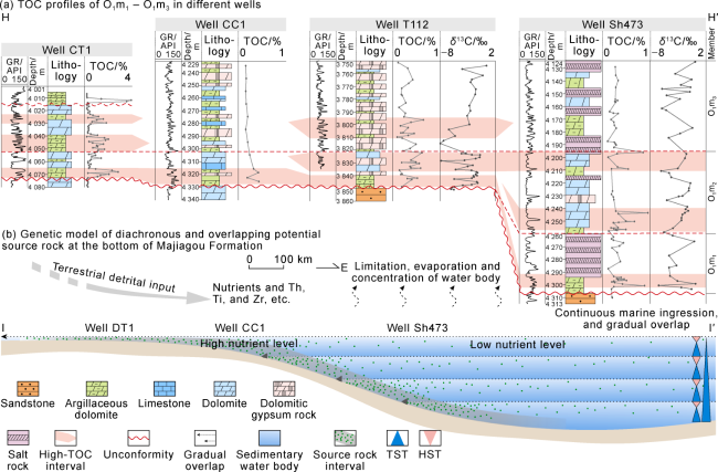
Fig. 9. Comparison of TOC at the bottom of Majiagou Formation and the genesis model of diachronous and overlapping source rock (TOC data of Well CT1 is from Reference [34]; the section position is shown in |
Fig. 10. Thickness map of the high-GR overlapping interval at the bottom of Majiagou Formation. |
Analysis suggests that there are three favorable conditions for the enrichment of organic matter at the bottom of the Majiagou Formation (Fig. 9b ): (1) Early overlap on the Ordos Ancient Land provided a large amount of terrestrial nutrients, conducive to improving ancient productivity [19]; (2) Water salinization in a confined environments was beneficial for microbial enrichment [33], providing a material basis for the development of source rocks [19,32]; (3) In the early Floian stag, global marine ingression [20] occurred on the ancient land and rapidly buried organic-rich argillaceous dolomite. The δ13C profile shifted positively, suggesting that terrestrial nutrient input increased the primary productivity, and at the same time, rapid marine regression buried more organic matter. This further indicates that early overlap on the Ordos Ancient Land is a key factor for the development of potential source rocks at the bottom of the Majiagou Formation.
4.2. Differentiated uplift-depression geomorphology controls the distribution of beach reservoirs
Core and thin section data show that granular dolomite, represented by dolarenite, oolitic dolomite, and bioclastic dolomite, are superior reservoirs with many residual intergranular pores and intergranular/intragranular dissolved pores (Fig. 4c -4e ), and high-quality reservoirs in the O1m2 and O1m3 members.
The reservoirs in the O1m2 and O1m3 members are distributed around sags and on highlands (Fig. 6b , 6c ). Most O1m2 reservoirs are on the east side of the Central Uplift, up to 20 m thick, and some are around the Qingyang Ancient Land. A few grain beaches may be in the west slope-break zone, but the reservoir may be poor due to low dolomitization. Vertically, the beach reservoir is mainly distributed in the middle slope of O1m22-3 (Fig. 5b ). According to the interpretation of logging data from Well E7, it is predicted that the beach reservoir in the O1m3 Member on the west margin of the Central Uplift is larger and distributed as stripes, and vertically in O1m32 (Fig. 5c ). The distribution on the east side of the Central Uplift and the two wings of the Wushen Banner-Jingbian Bulge is large, too, but the reservoir is thinner, and only 10-15 m locally in the north of Hengshan. Vertically, it is mainly in O1m31 (Fig. 5c ). In addition, the reservoirs on the slopes on the south and north sides are small and thinner than 5 m. The favorable grain beach facies belts in the O1m2 and O1m3 members show characteristics of being controlled by the differentiated uplift-depression geomorphology (Fig. 8 ). The distribution law around sags and on highlands strongly supports the exploration prospects of large-scale development of reservoirs on the slopes within the carbonate platform.
5. Conclusions
The argillaceous dolomite of margin facies, with high GR values and stably developed at the bottom of the Majiagou Formation is a marker bed for stratigraphic division. It is diachronously distributed on the tectonic unconformity caused by the Huaiyuan Movement, and accompanied by global marine ingression. The δ13C shows a significant positive drift.
When O1m1 and O1m2 deposited, the global sea level rose and submerged the ancient land. The resulting Central Uplift started to receive sediments during the Ordovician period, so a tectonic pattern appeared with one uplift and two depressions. When O1m3 deposited, there happened subduction and extrusion outside the basin and uplift-depression differentiation in the basin, and the Wushen Banner-Jingbian Bulge became active. Structural evolution had a significant impact on the sedimentary paleoenvironment. During the sedimentary period of the O1m1 Member, sediments overlapped westward, and marine ingression and isolation occurred on the East Depression. During the sedimentary period of the O1m2 Member, marine ingression continued, making the East Depression connect with surrounding open sea and large-scale grain beaches form around the East Depression. Late drying and shrinkage caused small lagoons on highlands. During the sedimentary period of the O1m3 Member, isolated by highlands, gradual differentiation and salinization shifted toward east, leaving grain beaches on the highlands. From the perspective of the coupling relationship between evaporite rocks and tectonic evolution, various salt rock sedimentary models are the important responses to the sedimentary differentiation effect under the coupling of paleotectonic geomorphological pattern and sea level fluctuation in the study area. Diachronous source rocks at the bottom of the Majiagou Formation and O1m2 and O1m3 beach reservoirs around slopes are favorable source-reservoir configuration with better natural gas accumulation conditions, and indicating a certain exploration potential.