

Introduction
Restoring the differential migration and accumulation history of deep marine oil and gas in superimposed basins is the key to elucidating the enrichment laws of deep oil and gas. The superposed basins in western China often experienced hydrocarbon accumulation processes of multiple stages of oil and gas charging, adjustment and reconstruction and multiple stages of tectonic activities [1⇓⇓-4]. As a result, the deep marine oil and gas fields are mostly formed due to the coupling of multiple factors during geological transformation [4-5]. This understanding not only summarizes the complexity and particularity of deep oil and gas but also poses new challenges for the study on the enrichment law of deep oil and gas. At present, with the progress of numerical simulation and artificial intelligence technologies [6], dynamic, quantitative and visual simulation methods have provided new solutions to the study of complex oil and gas genesis and distribution laws [7⇓⇓⇓⇓-12].
The Tahe Oilfield was the earliest marine carbonate fractured-vuggy oil and gas field discovered in China [13]. The Ordovician oil reservoirs are deep (generally deeper than 5 000 m), with the characteristics of differential accumulation of light, medium and heavy oil clear on the plane [14] (Fig. 1 ). Some studies suggested that the Ordovician reservoirs in Tahe Oilfield experienced multiple stages of hydrocarbon charging, migration, accumulation and reconstruction [15⇓⇓-18], but limited by traditional geological test methods, the genetic mechanism of the differential accumulation of oil and gas in the deep petroleum system of the Tahe Oilfield is still controversial. Some scholars believed that the mixing of late light oil and early heavy oil was the cause for multiphase oil and gas reservoirs [19], some believed that different paleogeomorphic units led to different reservoir structures [20-21], and others suggested that the evolution of strike-slip faults caused the differential accumulation of oil and gas [22]. After long-term exploration and development, the Tahe Oilfield faced difficulties such as rapid production decline and high well density [13,23⇓⇓ -26], so that it is urgent to expand new areas for increasing reserves and production. Previous studies on hydrocarbon accumulation relied mostly on single-factor static analysis [13-14,16⇓ -18], and the mechanism of dynamic adjustment and transform of deep oil and gas is still unclear, which constrains the evaluation and exploration of deep and ultra-deep hydrocarbon resources in Tahe Oilfield. In this study, constrained by seismic interpretation and dynamic production data of the Lower Paleozoic petroleum system of the Tahe Oilfield, the evolution of the key elements of the Lower Paleozoic petroleum system is restored by means of reservoir-forming dynamics simulation. Enrichment models of the differential accumulation of deep oil and gas are established to provide references to deep and ultra-deep resource evaluation and selection of favorable targets in the Tahe Oilfield.

Fig. 1. Study area location (a), plane distribution of Ordovician oil and gas (b) and composite stratigraphic column of Tahe Oilfield (c). |
1. Geologic setting
The Tahe Oilfield is located at the central‒southern end of the Akekule Uplift of the Shaya Rise in the Tarim Basin (Fig. 1a ), adjoining the Halahatang Depression to the west, the Caohu Depression to the east, the Manjiaer Depression and Shuntuogule Uplift in the south, and the Luntai Fault and Kuche Depression in the north, and covers approximately 7 000 km2 [13]. Tahe Oilfield is divided into six zones according to oil and gas production and missing formations: Main zone, Yanxia, Tuofutai, Aiding, Yuqixi and Yuqidong tectonic zones (Fig. 1b ). Since the formation of the pre-Sinian metamorphic basement, Tahe Oilfield has experienced tectonic movements including Caledonian, Hercynian, Indosinian and Himalayan movements, forming a Paleozoic nose-shaped bulge that inclined towards southwest and accumulated in the northeast direction. As a result, the Upper Ordovician‒Permian System in the northern part of the study area is almost missing, forming a regional unconformity [19]. Controlled by the changes of the regional tectonic stress field and the Tabei paleo-uplift, the Middle and Upper Ordovician extensively developed a NE‒NW-trending compressed pure shear X-type conjugate strike-slip fault system where the faults are nearly vertical and some of them extend into the Silurian-Devonian System. Late faults connecting with the early ones form a flower- shaped fault style which obviously controls the migration and accumulation of hydrocarbon in deep Tahe Oilfield [27⇓-29].
In the Tahe Oilfield, a set of marine petroleum system was developed in the Lower Paleozoic, featured by lower source and upper reservoir and cap [19]. The main source rock confirmed is the shale of the Lower Cambrian Yuertusi Formation deep-water shelf facies (Fig. 1c ), with Type II1 organic matter mainly and 6%-10% organic abundance [30-31]. Multiple sets of reservoirs are vertically developed in the marine petroleum system, including the dolostone reservoirs of the Cambrian Xiaoerbulake Formation, Shaylike Formation and Qiulitage Formation, the Ordovician Penglaiba Formation; and the limestone reservoirs of the Ordovician Yingshan Formation and Yijianfang Formation [13-14,32], which have been subjected to multiple stages of tectonic activity and karstification to develop large karst fractured-vuggy reservoirs [15]. The overlying Upper Ordovician Sangtamu Formation argillaceous limestone and Silurian-Carboniferous mudstone constitute the regional cap rock, whereas the thin gypsum interbeds in the Middle and Lower Cambrian Awattage Formation and Wusongger Formation [19] are isolating layers inside the Lower Paleozoic petroleum system. At present, the Ordovician Yijianfang Formation and Yingshan Formation are the targets for exploration and development in Tahe Oilfield, with proven crude oil reserves of approximately 13.5×10⁸ t and cumulative production of approximately 1×10⁸ t. The deep formations still have a large remaining resource potential [13].
2. Model construction of the petroleum system
2.1. Basic parameter settings for hydrocarbon source rock sedimentation and thermal evolution
2.1.1. Restoration of the burial history
The restoration of the burial history is the basic work of reservoir modeling, and relies on various data, including reservoir lithology, thickness, denudation and geological age [6]. The geological age follows the international standard, and the sequence division is based on the drilling data. For the wells that did not penetrate the Cambrian, the relevant layer depth values were obtained through adjacent drilling comparisons and seismic horizon tracking. The unconformity was restored following the stratigraphic trend, and based on the erosion amount measured in field. Lithology is an important basis for formation compaction correction and accurate burial history restoration [33-34]. Drilling and well logging data were used to estimate the lithologies and their percentage in the study area (Fig. 2 ), and a lithology percentage model was established based on the system standard lithology.

Fig. 2. Histogram of lithology percentage in the Tahe Oilfield. ——C1y—Yutertusi Formation; —C1x—Xiaoerbulake Formation; —C1w—Wusonger Formation; —C2s—Shayilike Formation; —C2a—Awatage Formation; —C3q—Qulitage Formation; O1-2— Middle and Lower Ordovician; O3—Upper Ordovician; S— Silurian; D— Devonian; C—Carboniferous; P—Permian; T— Triassic; J—Jurassic; K—Cretaceous; E—Paleogene; N— Neogene. |
2.1.2. Paleogeotherm recovery
The key to paleogeotherm recovery is determining the paleowater depth, paleo-heat flow and paleo-surface temperature in the study area. In particular, the paleowater depth model is very important for reconstructing the thermal evolution history and hydrocarbon generation and expulsion history of source rocks [34-35], which is determined on the basis of the lithofacies and paleogeographic environments in different geological periods. The paleo-heat flow is the product of rock thermal conductivity and geothermal gradient. Using the bottomhole temperature measured as a constraint, the geothermal gradient in Tahe Oilfield was estimated to be 3.5-1.8 °C/100 m, and the paleo-heat flow has gradually decreased since the Cambrian [35]. Using the default Wygrala (1989) model in PetroMod software, the paleosurface temperature was generally 16-30 °C in the Tarim Basin located near the Mid Asia Plate in the Northern Hemisphere (39 N).
2.2. Hydrocarbon generation dynamic parameters and deep hydrocarbon generation and expulsion model
An accurate dynamic model is the key to effectively restoring the history of hydrocarbon generation, migration and accumulation in a petroleum system.
According to the analysis of core and field profile samples, the average organic carbon content of the Lower Cambrian source rock in the northern Tarim Basin is approximately 10%, and the hydrogen index is approximately 550 mg/g, which is characterized by typical Type II1 kerogen, with a high abundance of organic matter and good hydrocarbon generation potential [29-30]. In this study, the Tissot in Waples (1990) TⅡ-Crack dynamic model, which has similar dynamic parameters of Lower Cambrian source rocks, was chosen as the basis for the restoration of hydrocarbon generation and expulsion history. This model has been validated by numerous experts that it conforms to the hydrocarbon generation process of Type II kerogen under geological conditions, and been widely applied in the field of petroleum exploration in China and abroad [36⇓-38]. The algorithms for determining hydrocarbon migration are important for the restoration of hydrocarbon accumulation history. At present, the algorithms commonly used mainly include streamline, invasion and percolation, and Darcy flow simulation technologies [39⇓-41]. This study used the hybrid flow technology fusing Darcy flow and invasion-percolation algorithms for the first time to characterize the migration and accumulation history of deep oil and gas and explore new concepts related to fluid migration and accumulation in fractured-vuggy media.
Based on the seismic section across the Toputai-Aiding- Yuqixi area, a deep petroleum system model (Fig. 3 ) was established, where the Lower Cambrian Yuertusi Formation is the hydrocarbon source rock, the reservoirs are the Lower Cambrian Xiaoerbulake Formation, the Middle Cambrian Shayilike Formation, the Upper Cambrian Qiulitage Formation, the Penglaiba Formation (O1p), the Yingshan Formation (O1-2y) and the Yijianfang Formation (O2yj) of the Ordovician, and the cap rocks are the Wusongger Formation-Awatage Formation, and the Upper Ordovician-Carboniferous. The fault attributes were set by the predefined parameters according to the geometry and properties of the faults [38-39].

Fig. 3. Deep seismic-geological interpretation section of the Tahe Oilfield (section location shown in |
2.3. Paleo-tectonic recovery
Paleo-tectonic restoration helps to reconstruct the burial history of source rocks, constrain the paths of hydrocarbon migration, and thus enables the identification of accumulation models in different geological periods. On the basis of 3D seismic tectonic interpretation of the Tahe Oilfield, the paleo-tectonic morphology of the key tectonic surfaces of the Middle Ordovician Yijianfang Formation during the Caledonian, Hercynian, Indosinian and Himalayan was restored via the back stripping method (Fig. 4 ). The conclusion is basically consistent with those from previous studies [1,15,41]. Tahe Oilfield was gentle at 400-1 500 m during the late Caledonian (Fig. 4a ), but the Yuqi area was relatively high. Affected by the Hercynian Movement, the overall paleo-geomorphology was a large nose-shaped structure basically in a saddle form and dipping from northeast to southwest (Fig. 4b ). The Indosinian structure inherited the paleo-geomorphic pattern of the Late Hercynian (Fig. 4c ). The geomorphic characteristics of the Himalayan still have inheritance, but it was low in southeast and high in northwest and accumulated in the northeast direction with the burial depth of 4 200-7 500 m due to the rapid subsidence during the Himalayan period (Fig. 4d ).

Fig. 4. The tectonic evolution history of the Middle Ordovician Yijianfang Formation in the Tahe Oilfield. |
3. Differential evolution of source rocks and hydrocarbon generation potential
The restoration of the thermal history of source rocks is a prerequisite for studying the genesis of hydrocarbons[11,33 -34]. To ascertain the maturity and thermal evolution history of source rocks in different structural belts in the Tahe Oilfield, wells S114, AD4, TP37, TS5, YQ12 and YQ2 in different tectonic zones were selected as representative samples, and the formation temperatures measured in the wells were used to constrain the thermal evolution history models of different structural zones (Fig. 5 ).

Fig. 5. Thermal evolution history of the Lower Cambrian source rocks in typical wells in the Tahe Oilfield (—C2—Middle Cambrian; —C3—Upper Cambrian). |
The Lower Cambrian source rocks in Tahe Oilfield experienced rapid burial during the Caledonian and then entered the mature stage. Staged uplifting occurred during the Hercynian and the Indosinian, and rapid and deep burial during the Himalayas let some zones enter the highly maturity stage. Due to the differences in thermal evolution and maturity, three thermal evolution models, namely, continuous burial, relay burial and long-term shallow burial, were developed in the Lower Cambrian in Tahe Oilfield. The continuous burial model is characterized by a continuous increase in temperature from the Caledonian to the Himalayan, with a vitrinite reflectance (Ro) value of 0.7%-2.1%, and generally in the highly mature to overmature stage. It occurs mainly in Tuofutai Zone, Yanxia Zone and Yuqidong Zone (wells S114, TP37, YQ12). The relay burial model is characterized by a staged temperature increase, with Ro between 0.6% and 1.5%, and generally in the mature to highly mature stage (wells AD4 and TS5). The long-term shallow burial model is characterized by a rapid temperature increase in the early stage and stagnation in the late stage. With Ro of 0.5-1.3%, the reservoir is in the mature to medium-high maturity stage (Well YQ2).
This study restored the hydrocarbon generation and expulsion history of typical Cambrian source rocks in different tectonic zones in Tahe Oilfield (Fig. 6 ). The model reveals that source rocks at the bottom of the Tahe Oilfield have experienced a “double peak” evolution history of early oil generation and late gas generation, with the hydrocarbon generation of the oil generation peak at 175-400 mg/g and the hydrocarbon generation at the peak of gas generation at 160-210 mg/g. Owing to the high degree of thermal evolution in Tuofutai Zone (Well TP37), Yanxia Zone (Well S114) and Yuqidong Zone (Well YQ12), the Caledonian oil generation potential exhibited narrow single-peak characteristics, reflecting the short oil generation period and long gas generation period. The Aiding Zone (Well AD4) and Main Zone (Well TS5) have relatively high oil generation potential and relatively low gas generation potential. Under the influence of intermittent tectonic uplift, the oil generation potential decreases slowly in a stepwise manner, and the gas generation potential gradually increases. In comparison, the Yuqixi Zone (Well YQ2) has been in the oil generation stage for a long period of time. The simulation of hydrocarbon generation and expulsion history reveals that the Lower Cambrian source rocks in the Tahe Oilfield began to expel hydrocarbons in the Early Ordovician (453 Ma), whereas hydrocarbon expulsion in the Aiding and Yuqixi areas lagged slightly. A statistical analysis of the relationship between the density of Ordovician crude oil and the maturity of Lower Cambrian source rocks in different tectonic belts of the Tahe Oilfield (Fig. 7 ) reveals a good correlation, indicating that the difference in the maturity of the Lower Cambrian source rocks is the main reason for the orderly distribution of the oil and gas phases in the Tahe Oilfield.
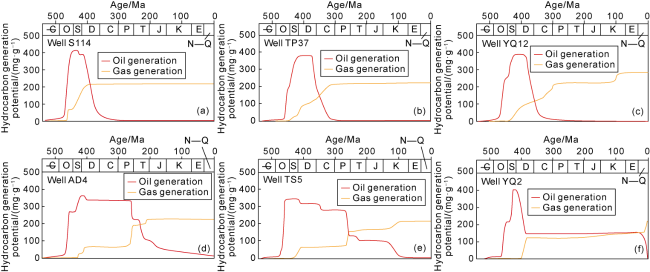
Fig. 6. Hydrocarbon generation and expulsion history of the Lower Cambrian source rocks in typical wells in the Tahe Oilfield. |
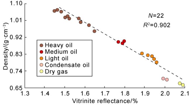
Fig. 7. Relationship of crude oil density and maturity of Lower Cambrian source rocks from different structural belts in the Tahe Oilfield (N represents the number of samples). |
4. Migration and accumulation of deep oil and gas
Exploration and development of the Ordovician reservoirs in Tahe Oilfield have confirmed that deep strike-slip faults, unconformities and transport layers are important channels for hydrocarbon migration [12⇓⇓⇓⇓-17]. However, historical research on the dynamic migration and accumulation of deep oil and gas along composite transport systems is relatively limited.
4.1. Vertical migration and accumulation
The dynamic simulation to the critical stage of reservoir formation reveals the history of hydrocarbon charge, migration, adjustment and transformation (Fig. 8 ). The simulation results reveal that the Caledonian was the initial stage of the Ordovician reservoirs when the structure was generally gentle, and under the action of compressional stress in the north-south direction, oil and gas in deep layers entered the Cambrian and Ordovician reservoirs vertically along the early strike-slip faults and accumulated in the fractured-vuggy traps (Fig. 8a ). The hydrocarbon phase was liquid, and the density of the normal crude oil was 0.89 g/cm3.

Fig. 8. Oil and gas migration and accumulation of the Ordovician Formation in Tuofutai, Aiding and Yuqixi areas in the Tahe Oilfield. |
The Hercynian was the critical period for the formation of Ordovician oil reservoirs. Affected by differential tectonic uplifting, the southern source rocks (Tofutai zone) subsided rapidly, and the thermal evolution increased rapidly with high intensity of hydrocarbon charging. The accumulation scale significantly increased in the Middle and Lower Cambrian traps and the Ordovician Yijianfang and Yingshan traps (Fig. 8b ). In the north (Aiding Zone, Yuqixi Zone), the overburden was uplifted and eroded, and some Ordovician oil and gas migrated along the faults and transport layers, and accumulated in Devonian and Permian traps, which is basically consistent with the current discoveries of oil and gas in the overburden in Tahe Oilfield [18]. The unconformity at the top of the Ordovician that formed in the Hercynian was the main pathway for lateral hydrocarbon migration, which is obvious in Tuofutai Zone during the Ordovician. The Aiding Zone and Yuqi Zone, which are located at the structural high, experienced mainly vertical hydrocarbon migration. During Hercynian period, there were also significant differences in the fluid phase. In particular, the oil and gas reservoirs of the Yijianfang Formation (O2yj) in Tuofutai Zone had a density of 0.79-0.83 g/cm3, and natural gas accounted for 8%-12%, indicating light oil reservoirs. The density of oil and gas reservoirs of the Yijianfang Formation in Aiding Zone and Yuqixi Zone was 0.85-0.86 g/cm3, with natural gas accounting for less than 1%, indicating that they were mainly normal reservoirs (Fig. 8b ).
Indosinian and Himalayan Ordovician hydrocarbon migration and accumulation had obvious inherited characteristics, and their difference lies in the fluid properties. Overall, the source rocks of the Tahe Oilfield have entered a highly mature stage. The density of crude oil gradually decreased to 0.62-0.88 g/cm3, and natural gas accounted for 0-47.3%. The Tuofutai Zone was charged with light oil and condensate oil, and the density of the crude oil in the Yuqixi zone was normal (Fig. 8c ). The charging intensity of deep gas in the Himalayas gradually increased with the sequence of condensate gas reservoirs, oil and gas reservoirs, and oil reservoirs formed in the Ordovician strata (Fig. 8d ). In general, the migration and accumulation of oil and gas in the Ordovician strata in Tahe Oilfield was featured by multistage charging and dominated by oil phase. The deep reservoir was dominated by the vertical hydrocarbon migration through strike-slip faults, adjusted and stimulated laterally in the Upper Ordovician. In particular, the deep fractures and caves provided the conditions for hydrocarbons to charge and accumulate, and the vicinity of the strike-slip faults was the main place for hydrocarbon enrichment in the deep layers.
4.2. Lateral migration and accumulation
To elucidate the adjustment and differentiation process of deep oil and gas at the top of the Ordovician strata in Tahe Oilfield, we restored the migration and accumulation trend at the top of the Yijianfang Formation during the Caledonian, Hercynian, Indosinian and Himalayan periods via the fluid potential technique (Fig. 9 ). Under the influence of the Ordovician paleo-tectonic pattern, the Caledonian Yijianfang Formation hydrocarbon accumulated from Yanxia Zone, Tuofutai Zone, and Main Zone to Aiding Zone, Yuqixi Zone and Yuqidong Zone, resulting in Caledonian ancient oil reservoirs. Affected by tectonic movements from the Hercynian to the Himalayan, ancient uplifts appeared in Main Zone, Yuqixi Zone, and Yuqidong Zone, and the hydrocarbon of the Yijiangfang Formation tended to accumulate from the Yuqi Zone, Yanxia Zone, and Tuofutai Zone to the Main Zone, Yuqixi Zone and Aiding Zone, forming a low potential area for hydrocarbon accumulation in the Main Zone and Aiding Zone. However, affected by the difference in the thermal evolution of the bottom source rocks during different periods, the oil and gas phases of the Yijianfang Formation exhibited significant divergence. The Caledonian was characterized by liquid hydrocarbon charging, while oil and gas two-phase charging, migration and accumulation was occurred in Yanxia Zone, Yuqidong Zone, and Tuofutai Zone from Hercynian to Himalayan. This is an important reason for light oil and gas in the eastern part of Tahe Oilfield. Affected by the thermal evolution of source rocks and different migration and accumulation patterns of hydrocarbons, early hydrocarbon was prone to accumulate into primary oil reservoirs in Tufutai Zone and Yanxia Zone, whereas affected by late differential charging and lateral adjustment, highly mature light oil and gas were captured. This is the main reason that the Ordovician production capacity in the Ordovician area is significantly lower than that in Aiding Zone. The Main Zone exhibits multisource accumulation of hydrocarbons, which leads to the highest oil and gas saturation in the Ordovician strata in this area (Fig. 10a ), whereas the crude oil in Tuofutai Zone and Yanxia Zone is light oil (with density of 0.76-0.78 g/cm3) (Fig. 10b ). The oil and gas flow path lines in whole Yuqi and Aiding zones were relatively short, reflecting the characteristics of in-situ charging and short-distance transformation. From the perspective of fluid potential distribution, the deep Ordovician hydrocarbon has differential accumulation characteristics of “early oil and late gas, gas in east and oil in west, migration from south and accumulation in north”. The low fluid potential in Main Zone has obvious inheritance characteristics.

Fig. 9. Hydrocarbon migration and accumulation trend in critical transformation stages of the Ordovician Yijianfang Formation in the Tahe Oilfield. |
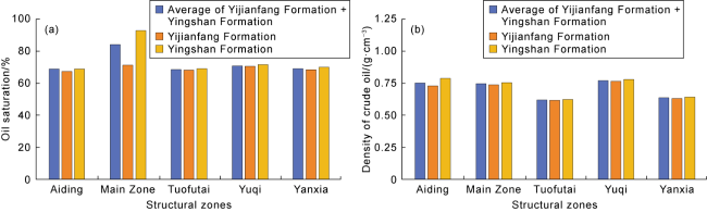
Fig. 10. Histograms of oil saturation (a) and crude oil density (b) in different structural zones of Ordovician in the Tahe Oilfield. |
5. Simulation to multifactor controlling reservoir history
The enrichment of oil and gas in the deep formations in superimposed basins is usually the result of the long- term coupling of multiple factors including source rocks, strike-slip faults, traps and preservation conditions [3-4]. On the basis of detailed 3D seismic and geological interpretation results, a numerical model of the Lower Paleozoic petroleum system was established with the parameters and boundary conditions similar to those above, and the evolution history of the Lower Paleozoic petroleum system in Tahe Oilfield was restored by using the hybrid flow algorithm (Fig. 11 ). According to the simulation results, during the Caledonian, deep oil and gas began to accumulate near the Ordovician strike-slip fault zones. From the Hercynian to the Himalayan, as the thermal evolution of source rocks at the bottoms of Yuqidong Zone, Yanxia Zone and Tuofutai Zone increased, two- phase (oil and gas) fluid charging occurred. The Main Zone was mainly charged with liquid hydrocarbons from deep formations through strike-slip faults. However, there is a significant gas invasion phenomenon in Yuqidong Zone and Yanxia Zone (from the Hercynian to the Himalayan), and oil and gas migrated laterally. This may be related to the strong sealability of the Middle Cambrian gypsum-salt rocks (pink in Fig. 11 ) in Main Zone [16⇓⇓-19].

Fig. 11. 3D dynamic evolution simulation of the Lower Paleozoic petroleum system in the Tahe Oilfield. |
In Yuqixidong Zone and Yanxia Zone, the marlstone of slope facies (gray in Fig. 11 ) [42] was easy to be broken through by deep hydrocarbons, resulting in a differential pattern of gas in the east and oil in the west. The dynamic simulation results also reveal that deep oil and gas clearly migrate and accumulate differently in the X-type conjugate strike-slip fault system (Fig. 12 ), and hydrocarbons are prone to accumulate in Ordovician fractures and caves in the NE strike-slip fault zone (F1) (Fig. 12a , 12b ). On the other hand, the NW strike-slip fault (F2) is consistent with the hydrocarbon migration path, leading to its main role in transportation (Fig. 12c ), and reflecting the controlling role of the X-shaped strike-slip faults in the differential accumulation of hydrocarbons in Tahe Oilfield (Fig. 12d ). As a result, deep oil and gas in Tuofutai Zone exhibit obvious fault-controlled characteristics and are mainly distributed in a beadlike shape along the NE strike-slip faults. The simulation results indicate that the low potential zone affected by the NE strike-slip fault zone and deep oil and gas migration, and the dominant migration channels are conducive to the accumulation of oil and gas.
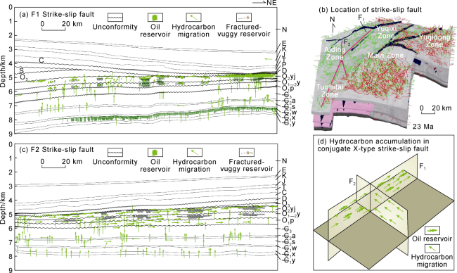
Fig. 12. Simulation of hydrocarbon migration and accumulation on the Ordovician strike-slip fault plane in the Tahe Oilfield. |
Residual volume and hydrocarbon loss are direct indicators of hydrocarbon migration and accumulation. On the basis of the simulation results, the residual amount and escape amount of oil and gas in the internal layers of the Lower Paleozoic strata during different periods were calculated (Fig. 13 ). The results show that deep hydrocarbon began to charge during the Caledonian and then migrated from deep to shallow formations. The residual hydrocarbon in the Ordovician Yijianfang Formation and Yingshan Formation, and the Middle Cambrian is the largest, totally over 1 500×106 t. The Xiaoerbulake Formation located in pre-salt field of the Middle Cambrian was near to the source, so the residual volume at early stage was high, but that at late stage decreased due to vertical migration and reached approximately 500×106 t at present. The residual hydrocarbon in the Ordovician Penglaiba Formation and the Upper Cambrian was relatively low, approximately 180×106 t, and basically consistent with the real exploration and development result in Tahe Oilfield currently. Oil and gas escape statistics reveal that approximately 2 200×106 t from the Ordovician Yijianfang Formation, accounting for 49.2%, and approximately 220×106 t from the Yingshan Formation (Fig. 13b ), accounting for 3.7%, indicating that deep oil and gas have been in a dynamic equilibrium of migration, accumulation and escape. It is an important issue that needs attention in the evaluation of deep oil and gas resources.
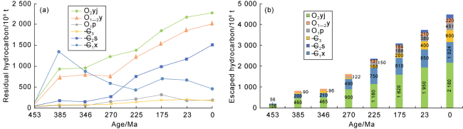
Fig. 13. Variation of residual (a) and escaped (b) hydrocarbons in different formations of the Lower Paleozoic in the Tahe Oilfield. |
6. Differential accumulation model of deep oil and gas
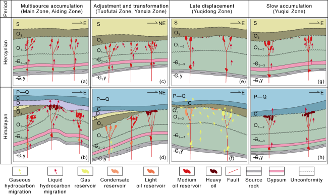
The dynamic simulation results suggest that the differential thermal evolution of the Lower Cambrian source rocks controls the oil and gas phases in the deep petroleum system, and it is the main cause for present accumulation model featured by gas in the east and oil in the west. Strike-slip faults are the main channels for deep oil and gas migration. Deep interior fractures and caves along the strike-slip faults have the conditions of near-source charging and priority accumulation. Oil and gas in the Middle and Upper Ordovician strata were affected by the lateral adjustment of unconformities, and the NE strike-slip faults were more conducive to oil and gas enrichment. The distribution of the Cambrian gypsum-salt rock controls the scale of differential accumulation of oil and gas in the deep formations. The strike-slip fault activities in Main Zone and Aiding Zone, and the sealing effect of the Middle Cambrian gypsum-salt rock determine the charging intensity of deep hydrocarbons, resulting in a multistage and multisource accumulation history (Fig. 14a , 14b ). The Tuofutai Zone and Yanxia Zone etc. are characterized by early oil accumulation and late lateral migration, which is the adjustment and transformation of accumulation models (Fig. 14c , 14d ). In Yuqidong Zone, under the influence of development of Middle Cambrian slope marlstone on vertical charging and lateral migration of oil and gas, early oil was displaced by late natural gas. This is the main reason for forming condensate and dry gas reservoirs in the Ordovician and deep formations (Fig. 14e , 14f ). In Yuqixi Zone, affected by the relatively low maturity of source rocks at the bottom, a slow oil accumulation model took place in the Ordovician (Fig. 14g , 14h ).
Fig. 14. Differential accumulation models of Ordovician oil and gas in different tectonic zones in the Tahe Oilfield. |
The preservation condition is an important reason for the distribution of “heavy oil in the north and light oil in the south” in the Ordovician reservoirs in the Tahe Oilfield. The erosion of the Upper Ordovician cap rock and the opening of strike-slip faults in Aiding Zone, Main Zone, and Yuqixi Zone led to the escape of oil and gas, forming a heavy and ultraheavy oil area. The Upper Ordovician caprocks developed in the Tuofutai Zone, Yanxia Zone and Yuqidong Zone, which provides a good preservation condition for oil and gas reservoirs, forming medium‒light oil reservoirs. The dynamic simulation results confirmed that the good temporal and spatial configuration among source rocks, gypsum-salt rock, strike-slip faults and preservation conditions control the differential oil and gas enrichment in the deep petroleum system in Tahe Oilfield, resulting in the current oil and gas differentiation pattern featured by "eastern gas and western oil, southern migration and northern accumulation". It's demonstrated that the Ordovician Yingshan Formation and Penglaiba Formation have a good exploration and development potential, and the Middle and Upper Cambrian have great potential of resources. On the plane, the intersection of the NE strike-slip fault zone and the hydrocarbon migration path in the low exploration areas of Yuqidong Zone and Yanxia Zone is conducive to the enrichment of late light oil which deserves further evaluation.
7. Conclusions
The thermal evolution simulation of the Lower Cambrian source rocks in Tahe Oilfield revealed that the deep source rocks experienced multistage thermal evolution in three modes: continuous burial, relay burial and long-term shallow burial. The history and intensity of hydrocarbon generation and expulsion in different tectonic zones differ significantly, which is the main cause for the different deep oil and gas phases.
The simulation of hydrocarbon migration and accumulation in the petroleum system revealed that the Ordovician accepted multiple stages of hydrocarbon charging, with oil as the dominant phase. Vertical migration along strike-slip faults and lateral migration of hydrocarbon in the Upper Ordovician played an important role in hydrocarbon accumulation. The composite transport system consisting of strike-slip faults and unconformities controlled differential hydrocarbon migration and accumulation. Affected by the distribution of inter-platform Middle Cambrian gypsum rock, fractures and caves near strike-slip faults are the dominant spaces for hydrocarbon charging and accumulation in deep formations.
The multifactor coupling reservoir-forming simulation revealed that the temporal and spatial configuration of “source-faults-fractures-gypsum-preservation” controls the differential hydrocarbon enrichment in the deep petroleum system in Tahe Oilfield, with the characteristics of multisource accumulation in Main Zone and Aiding Zone, intense lateral adjustment in Tuofutai Zone and Yanxia Zone, in-situ charging and slow oil accumulation in Yuqixi Zone, and high hydrocarbon charging intensity and late gas displacement in Yuqidong Zone. The distribution of deep oil and gas is in a beadlike shape along the NE strike-slip faults with obviously “fault-controlled” characteristic. The low potential zone affected by northeast strike-slip faults and deep hydrocarbon migration is conducive to accumulation.
The dynamic simulation revealed that the Ordovician reservoir in the Tahe Oilfield experienced a history of multistage charging, vertical migration and accumulation, and lateral adjustment and transformation, resulting in a differential pattern of early oil and late gas, eastern gas and western oil, and southern migration and northern accumulation. Residual hydrocarbon statistics show that the deep Ordovician Yingshan Formation and Penglaiba Formation have a good exploration and development potential, and the Middle and Upper Cambrian have great potential of resources. On the plane, the intersection of the NE strike-slip fault zone and the hydrocarbon migration path in the low exploration areas of Yuqidong Zone and Yanxia Zone is conducive to the enrichment of late light oil.