

Introduction
Global buried hill hydrocarbon exploration began in Venezuela in the 1950s [1-2]. Buried hill oil and gas exploration has been successful, and billions of tons of reserves have been discovered in the Bongor Basin in Africa [3-4], the Mekong Basin in Vietnam in Southeast Asia [5], and superimposed basins in western China and rift basins in eastern China [6⇓-8]. Compared with conventional oil and gas reservoirs, buried-hill reservoirs are primarily metamorphic, carbonate and igneous rocks. These rocks not only develop dissolution pores and fractures but also exhibit strong resistance to compaction and relative insensitivity to depth, making them key targets for deep and ultra-deep oil and gas exploration (with depths below 3 500 m considered deep and depths below 4 500 m considered ultra-deep in the Bohai Sea area) [7⇓-9].
The Bohai Oilfield is the largest crude oil production field in China. Since the discovery of industrial oil and gas flows in the buried hills in the eastern section of the Shijiutuo Uplift in the Bozhong Sag in the 1970s, buried hills have become a crucial part of the exploration strategy of the Bohai Oilfield [9⇓⇓⇓-13]. Influenced by multiple tectonic movements, buried hills in the Bohai Sea area are complex and composed of three tectonic layers [14-15]: Archean/ Proterozoic granite/metamorphic rock (basement), Paleozoic marine carbonate/clastic rock, and Mesozoic clastic/volcanic rock. Differences in lithology and vertical superimposition result in diverse types of buried hills in the offshore Bohai Sea Bay Basin.
During the early stages of buried hill exploration, single-layer buried hills of the Archean/Proterozoic tectonic layer, characterized by suitable locations, favorable hydrocarbon accumulation conditions, and shallow burial depths, were easy to image via seismic methods and thus became hotspots for exploration. Successful discoveries have been made, such as in the JZ25-1S and BZ19-6 buried-hill oilfields [14⇓⇓⇓-18]. However, with increasing exploration activities, single-layer buried hills have become increasingly difficult to find. Composite buried hills, which are made up of two to three pre-Cenozoic tectonic layers, are the focus of current exploration. Despite being composite due to multiple tectonic movements, they are widely distributed in hydrocarbon-rich depressions near the source kitchens. Before 2015, a number of complex buried-hill oil and gas fields, such as BZ28-1, 428W, PL9-1 and CFD12-6, were discovered [19], with cumulative proven reserves exceeding 2.5×10⁸ t, and demonstrating an excellent exploration potential of composite buried hills. However, challenges like unclear distribution patterns, unknown reservoir development mechanisms, and ambiguous accumulation factors are brought on by the complexity of composite buried hills.
On the basis of 3D seismic interpretation, drilling data, cores and thin sections and lab analysis and considering Mesozoic and Cenozoic tectonic dynamics, buried-hill reservoirs and differential oil and gas accumulation patterns, this paper analyzes the necessary conditions for the development of buried hills and reservoirs and hydrocarbon accumulation in large deep and ultra-deep composite buried hills in the offshore Bohai Sea Bay Basin. This study aims to provide an overview of the conditions for deep and ultra-deep large composite buried-hill oil and gas reservoirs in the offshore Bohai Sea Bay Basin, as well as to analyze the mechanisms and distribution of large composite buried hills and reveal the mechanisms of reservoir formation. The findings support successful buried hill exploration and offer scientific direction for buried hill exploration in the Bohai Oilfield and other geological settings in eastern China.
1. Geological settings
The offshore Bohai Sea Bay Basin covers approximately 6×10⁴ km2 and is located in the Bohai Sea Bay Basin on the North China Plate [10] (Fig. 1a ). The buried hills in the offshore Bohai Sea Bay Basin have undergone multiple episodes of tectonic evolution. About 1.8 billion years, the eastern and western blocks of the North China Craton collided along the central orogenic belt, forming a unified continental craton [19⇓-21]. From the Middle Proterozoic to the Early Triassic, the North China Craton remained stable. Since the Late Triassic, it has undergone intense disruption and reformation caused by the successive occurrences of the Indosinian, Yanshanian and Himalayan movements [22⇓-24], which resulted in complex tectonic evolution and stratigraphic distribution of composite buried hills. The buried hills in the offshore Bohai Sea Bay Basin were overlain by the Neozoic, including the Paleogene (fan-delta/braided river delta and semideep to deep lacustrine deposits of the Kongdian Formation, Shahejie Formation and Dongying Formation developed in the rifting stage), the Quaternary (fluvial deposits of the Guantao Formation and Minghuazhen Formation developed in the sag stage), and the Neogene (shallow-water delta deposits) [25-26] (Fig. 1b ).
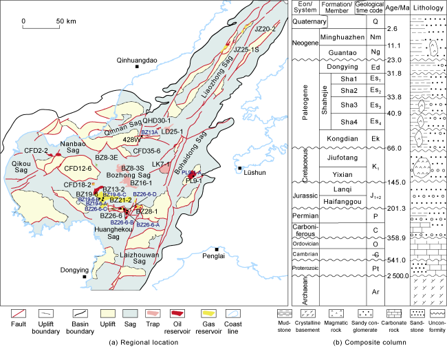
Fig. 1. Regional location and lithological column. |
2. Tectonic background and distribution of composite buried hills
2.1. Tectonic background
2.1.1. Double-episode destruction
Since the Mesozoic and Cenozoic, the North China Craton has undergone destruction by the subduction of the Pacific Plate, which has resulted in intense extensional tectonics, topographic uplift and subsidence, and frequent volcanic eruptions within the craton [19⇓-21,24]. On the basis of magmatic geochronology studies and crustal thickness reconstruction, the offshore Bohai Sea Bay Basin of the North China Craton is believed to have been destroyed by two episodes.
The first episode occurred from the middle to Late Yanshanian Orogeny (Cretaceous, 65-139 Ma). In the offshore Bohai Sea Bay Basin, breaking and sinking of cratonic lithospheric basement and rapid upwelling of asthenosphere caused frequent and intense magmatic activities, which results in a widespread distribution of intermediate to acidic intrusive and extrusive rocks. At the same time, the crustal thickness decreased sharply from 70-80 km to 30-40 km, marking the first thinning event.
The second episode occurred during the early Himalayan Orogeny (Paleogene, 23-66 Ma). The North China Craton basement experienced a second detachment and sinking process associated with upwelling of strong asthenosphere, which further exacerbated the extensional tectonics in the basin [27⇓-29]. The crust underwent a second thinning process to finally reach depths of 25-35 km. Unlike the first destruction, basic extrusive rocks were dominant in the second destruction.
These changes reveal a continuous thinning trend in the crust of the North China Craton since the Mesozoic and Cenozoic and clearly reflect the transition of magmatic rocks from intrusive to extrusive rocks and from acidic to basic volcanic rocks. This dual transformation mechanism of crustal thickness and magmatic type reflects complex dynamics and geological responses in an episodic destruction process.
2.1.2. Development and evolution of buried hills
Two angular unconformities at the Mesozoic top and the Paleogene top are direct evidence of tectonic activity (Figs. 2 and 3 ). Structural evolution and apatite fission track analysis [30⇓⇓-33] revealed that the Bohai Bay Basin underwent four key evolutionary stages closely related to the two episodes of destruction (Figs. 2 , 4 and 5).
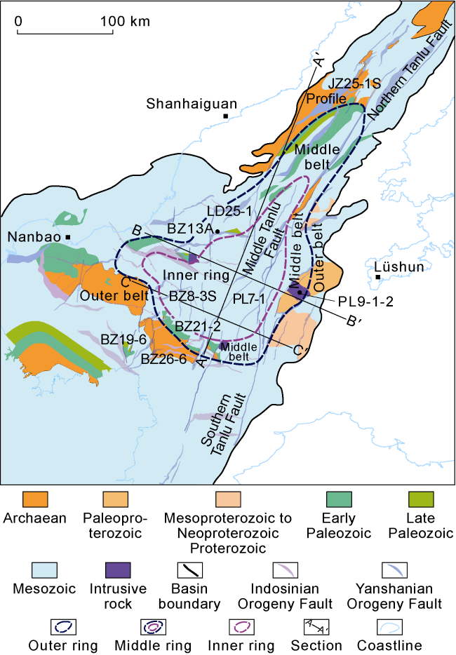
Fig. 2. Distribution of composite buried hill groups in the offshore Bohai Sea Bay Basin. |

Fig. 3. Seismic sections of the Bozhong Sag (See the section location in |
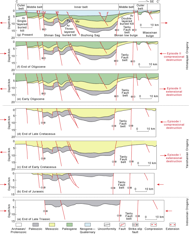
Fig. 4. Tectonic evolution of the Bozhong Sag related to double-episode destruction (see the section location in |
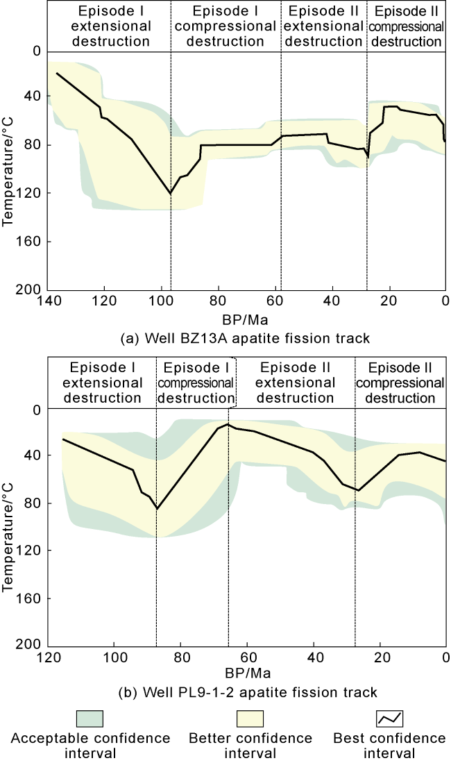
Fig. 5. Apatite-fission track around the Bozhong Sag. |
(1) Episode I extensional destruction. During the Early Cretaceous, the offshore Bohai Sea Bay Basin transitioned from a relatively flat craton to a rift basin, accompanied by intense volcanic activity. The region underwent initial rifting, and the terrain was reshaped into a complex graben-horst system, with rapid deposition and accumulative thickness of 2 000-3 000 m.
(2) Episode I compressive destruction. At the end of the Late Cretaceous, the offshore Bohai Sea Bay Basin was uplifted as a whole and underwent significant erosion so that the thickness decreased by 1 000-2 000 m. The original shape of the buried hills gradually formed, marking a critical point in the destruction of the craton.
(3) Episode II extensional destruction. At the early Paleogene, the offshore Bohai Sea Bay Basin experienced extensional destruction and local volcanic activity, causing the basin to further rift, accompanied by large-scale tilting and subsidence. The depositional rate increased, and the thickness increased to 1 000-10 000 m. Abundant source rocks have been deposited in the offshore Bohai Sea Bay Basin and provide a foundation for hydrocarbon accumulation in buried hills.
(4) Episode II compressive destruction. At the end of the Oligocene, the offshore Bohai Sea Bay Basin experienced compressive destruction, resulting in uplift of the basin and crustal erosion of 500 m to 1 500 m. The buried hills were finally shaped.
In summary, the double-episode destruction of the craton since the Mesozoic-Cenozoic involved two cycles of extensional rifting and compressive erosion. An extensional rift caused detachment and subsidence of the deep structures, whereas compressive erosion destroyed the shallow structures in the lithosphere. The extensional and compressional tectonic activities not only resulted in the continuous thinning of the crust and rifting of the craton in the offshore Bohai Sea Bay Basin but also reshaped the configuration of the basin and buried hills through differential uplift and subsidence, promoting the extension, tilting and compression of the buried hills. The two episodes of destruction to the craton from the Mesozoic to the Cenozoic were the primary driving forces for the development of the deep to ultra-deep composite buried hills in the offshore Bohai Sea Bay Basin.
2.2. Types and distribution of buried hills
2.2.1. Types of buried hills
Unlike the continuous “compressive uplift into mountains” in western China [6⇓-8], a unique path of “extending and extruding into hills” took place in the Baohai Sea area. Therefore, the buried hills succeeded the pretectonic formations (the Archeozoic/Proterozoic, Paleozoic and Middle-Lower Jurassic) and were covered by the formations deposited during the cratonic destruction period (such as the Cretaceous and Paleogene). The superposition formed composite buried hills with multilayer structures (Figs. 3 and 4 ).
The buried hills in the offshore Bohai Sea Bay Basin can be divided into the following three categories according to their temporal and spatial distributions (Figs. 3 and 4 ):
Single-layered buried hills of the Archean/Proterozoic. This kind of buried hill is mainly distributed in long-term successive structural highs, such as the Jinzhou 25-1S and Bozhong 19-6 buried hills.
Double-layered buried hills of the Mesozoic + Archeozoic/Proterozoic or the Paleozoic + Archeozoic/Proterozoic. These kinds of buried hills are mostly distributed in intermittent structural highs, such as the Lüda 25-1 and Bozhong 21-2 buried hills.
Three-layered buried hills of the Mesozoic, Paleozoic and Archeozoic/Proterozoic. This kind of buried hill is located mainly in long-term subsidence centers, such as the Bozhong 8-3S and Longkou 7-1 buried hills.
In particular, single-layered buried hills are also called “buried hills” because of their Archean/Proterozoic basement. Double-layered buried hills and three-layered buried hills are called “composite buried hills” because of their complex structures.
2.2.2. Distribution of the buried hills
During the Mesozoic period, plate subduction gradually changed from progressive to eastward retreating [19⇓-21]. The transition deeply affected the basement of the North China Craton, resulting in destruction and detachment and, consequently, thinning of the lithosphere. Magmatic activity also expanded westward, and the eastern part of the Bozhong Sag became the area with the most frequent and intense volcanic activity (Fig. 6 ) [19⇓-21,27⇓ -29].
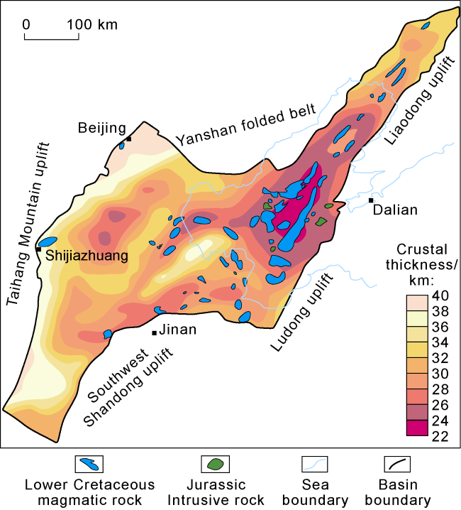
Fig. 6. Crustal thickness and volcanic rock distribution in the Bohai Sea Bay Basin. |
During the Cenozoic, the Pacific Plate continued retreating and subducting, exacerbating extensional rifting and crustal thinning in North China. During this process, the deposition and subsidence center underwent significant changes. It continued migrating from west to east and ultimately made the Bozhong Sag the major subsidence center of the Cenozoic sediments.
In addition, the Tan-Lu Fault Zone, where the study area is located, has undergone intense activity since the Mesozoic-Cenozoic. The basin formation time differed across the different regions. For example, the southern Bohai area began to form a basin after rifting in the Early Cretaceous, the Liaodong Bay segment formed a basin during the Eocene-Oligocene, and the Bozhong segment formed a basin during the Oligocene--Pliocene. This difference in basin formation time reflects the gradual convergence of the Tan-Lu fault zone from southern and northern areas toward the central Bozhong Sag [23,34].
In summary, the destruction center shifted from the basin margin toward the Bozhong Sag from west to east, while the Tan-Lu Fault converged toward the Bozhong Sag, making the Bozhong Sag a tectonic and subsidence center in the Bohai Sea Bay Basin.
A comprehensive analysis of seismic interpretation and regional tectonic evolution in the offshore Bohai Sea Bay Basin reveals a zonal distribution pattern of buried hills centered around the Bozhong Sag (Figs. 2-4).
(1) Inner belt: Located in the center of the Bozhong Sag and the middle segment of the Tan-Lu Fault, and at depths of 4 500-10 000 m, the inner belt has a complete stratigraphic sequence consisting of three layers of buried hills, including Archean (locally residual Proterozoic), Paleozoic and Mesozoic hills, which are 22-23 km thick in total. It is the thinnest zone with the thickest volcanic rock in the Bohai Sea Bay Basin, and the center of the double-disruptions to the North China Craton, especially in the late subsidence center.
(2) Middle belt: Almost located on the slope or steep slope of the Bozhong Sag, at 2 500-5 000 m, the middle zone experienced relatively weak erosion. Double-layered buried hills of the Archean + Mesozoic or the Archean + Paleozoic are dominant. Its average thickness is 26-27 km. It is a transitional zone caused by activities from tensile to compressive.
(3) Outer belt: Almost located on the uplift of the Bozhong Sag, at 1 500-4 000 m, the outer zone experienced severe erosion, so it is only 30-36 km thick. Single-layered Archean/Proterozoic buried hills are dominant. It is the core uplifting zone during the double-episode destruction.
In summary, under the joint control of craton destruction and Tan-Lu fault activity, the destruction center migrated toward the Bozhong Sag and gradually converged into buried hills in the offshore Bohai Sea Bay Basin.
3. Formation mechanisms of the dissolution pore-fracture development zone in composite buried hills
3.1. Characteristics of the dissolution pore-fracture development zone
The composite buried hills in the middle and inner belts are below 2 500 m and almost below 4 000 m. It is generally believed that the porosity of the reservoir below 4 000 m is less than 5%, so the reservoir has low porosity and low permeability and is difficult to control effectively[35⇓-37]. Observations of sidewall cores and thin sections, and on the basis of rock mechanics, reveal that dissolution pores and fractures (called pore‒fracture zones) exist in deep composite buried hill reservoirs. Below the unconformity, these buried‒hill reservoirs are continuous or intermittent at 300-1 000 m. These reservoirs are divided into porous reservoirs, porous‒fractured reservoirs, and fractured reservoirs (Fig. 7 ). The porosities of the pore-fracture zones range from 5% to 12%, indicating good reservoir properties.
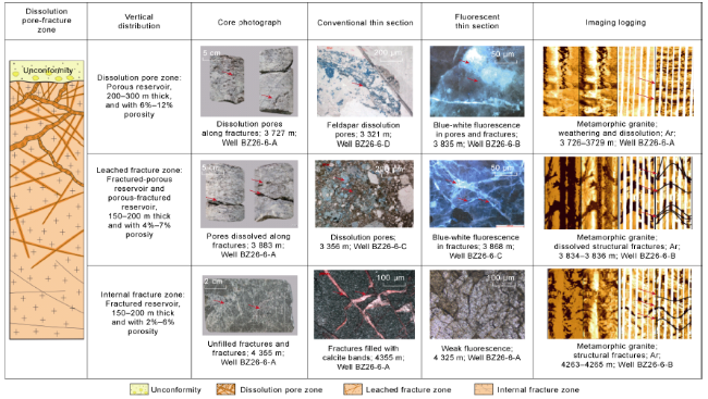
Fig. 7. Vertical distribution of dissolution pore-fracture zones in BZ26-6 buried hill. |
The buried hill reservoirs can be clearly divided into three vertical zones: the dissolution pore zone, the leached fracture zone, and the internal fracture zone (Fig. 7 ). The dissolution pore zone formed by weathering and dissolution is below the unconformity and adjacent to the top of the buried hills. It is 200-300 m thick and has a high porosity ranging from 6% to 12%. The reservoir space is mainly composed of dissolution pores, especially large pores. These pores, which are usually accompanied by enlarged fractures, are almost feldspar moldic pores. The leached fracture zone is below the dissolution pore zone, is 15 m to 200 m thick and has a slightly low porosity of 4% to 7%. The reservoirs are nearly porous-fractured and fractured-porous. The pores are usually dissolved along network fractures, indicating significant control of the fractures on the dissolution pores. The internal fracture zone is below the leached fracture zone and is 150 m to 400 m thick, and the porosity is only 2% to 6%. The reservoir space is mostly composed of fractures with straight and smooth edges. Influenced by lithological differences, the fracture zone has an intermittent vertical distribution. Along the fractures, plum-shaped pyrite precipitates and a small number of dissolution pores are visible, indicating a certain degree of hydrothermal dissolution.
3.2. Formation of the dissolution pore‒fracture zone
The composite buried hills in the offshore Bohai Sea Bay Basin have undergone Indosinian, Yanshanian and Himalayan movements, which have caused multidirectional and multistage fracture/fault systems and widespread weathering and dissolution phenomena [38-39]. Notably, the deep and ultra-deep Mesozoic formations distributed in the middle and inner belts did not experience Indosinian Movement, which induced the development of fractures and pores, so these formations are traditionally called undeveloped porous-fractured reservoirs. Core observations and thin section analysis revealed the following: (1) Indosinian fractures are mainly northwest‒southeast compressive fractures with large openings, approximately 238 Ma according to U‒Pb dating of calcite, and are almost completely filled with mud, quartz and calcite; (2) Yanshanian fractures are nearly highly dipping shear fractures trending northeast‒southwest, approximately 155 Ma, mostly concentrated in strike‒slip fault zones and incompletely filled with calcite and ankerite; (3) Himalayan fractures are more common than Indosinian and Yanshanian fractures, trending northeast‒southwest, approximately 28 Ma, and filled with pyrite and calcite (Fig. 8 ).
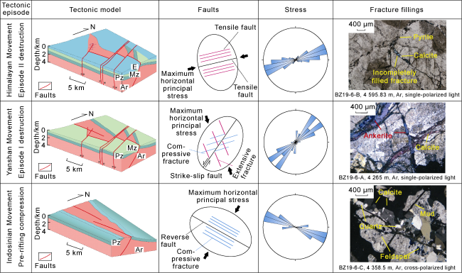
Fig. 8. Fracture development stages in the offshore Bohai Sea Bay Basin. |
According to the fission track data and tectonic evolution analysis (Fig. 5 ), compressive destruction during the first episode of the Yanshanian Movement and the second episode of the Himalayan Movement played important roles in the development of pore and fracture zones in composite buried hills. The active zones of these two compressive episodes are the zones where pores and fractures are developed. Most fractures are open or not filled with minerals due to late development and short burial. Although the Mesozoic formations in the middle and inner belts did not experience Indosinian Movement, which was affected by double-episode destruction to the Mesozoic-Cenozoic Craton, pores and fractures are still abundant.
4. Mechanism and model of differential hydrocarbon accumulation in composite buried hill reservoirs
4.1. Differential accumulation mechanism
4.1.1. Thickness differences between source and cap rocks
Large and medium buried-hill oil and gas fields have a large hydrocarbon window, which is generally over 70 km2, provides abundant sources for oil and gas accumulation [40-41]. However, the composite buried hill traps discovered in the offshore Bohai Sea Bay Basin have a hydrocarbon window of less than 40 km2, which has long been considered unfavorable for hydrocarbon accumulation. Furthermore, during the Himalayan Orogeny, intense faulting posed challenges to the large-scale preservation of hydrocarbons, especially in the outer belt, where poor preservation contributed more to the failure of oil and gas exploration in some single-layered buried-hill reservoirs [12⇓⇓⇓-16].
According to the analysis of tectonic evolution and hydrocarbon source evolution, during the second phase of craton destruction, the Bozhong Sag underwent rapid subsidence, and the maximum fault activity rate reached 320 m/Ma. A total of 500-4 000 m thick dark mudstone of semideep to deep lacustrine subfacies overlie buried hills, including the Paleogene Kongdian Formation, Shahejie Formation and Dongying Formation, with TOC values ranging from 1.5% to 5.0% and type I-II organic matter. After the Pliocene, the Paleogene mudstone quickly reached the hydrocarbon generation threshold at 3 000 m, and the source rock matured. When Ro values were 1.7% to 2.5%, gas generation peaked, resulting in overpressure [42-43]. The pressure coefficient ranged from 1.4 to 2.0, and the residual pressure was between 20 MPa and 60 MPa. The overpressured mudstone acted as a source rock and cap, providing favorable hydrocarbon charging and preservation conditions for hydrocarbon accumulation in composite buried hills. Statistical analysis indicates that the larger the pressure coefficient is, the more favorable the charging and sealing conditions, and the greater the proven reserves in the buried hills.
The composite buried hills in the middle and inner belts are closer to the subsidence center and experienced faster and greater subsidence, so they have good source rocks, strong hydrocarbon charging and preservation conditions.
4.1.2. Internal structures
Traditionally, the internal structures of buried hills are believed to be simply layered or blocked. However, actual drilling data revealed complex internal structures featuring isolators.
In particular, near early faulted and attenuated strike-slip zones and large oblique intrusions, dense mylonite zones are frequently encountered during drilling operations. For example, mylonite zones along Mesozoic strike-slip faults were discovered in the BZ26-6 structure, and mylonite zones near Mesozoic Proterozoic magmatic intrusions were exposed in the PL9-1 structure (Fig. 9 ). These mylonite zones extend hundreds of meters vertically, are gray‒green and dark gray, and are unique strips and laminae [44-45]. Thin section analysis revealed that the mylonite exhibited distinct flow and oriented structures, which were primarily composed of biotite and chlorite, with dark minerals significantly outnumbered light minerals. Core physical property analysis revealed that the mylonite zones have extremely low porosities (averages of 0.57%). The breakthrough pressure is high, from 10.1 MPa to 70.4 MPa, resulting in a better sealing capability than that of mudstone at the same depth. The mylonite zones play crucial roles in blocking and preserving hydrocarbons in the lower and internal parts of the buried hills.

Fig. 9. Seismic profiles and microstructures of lateral sealable mylonite in buried hills. |
4.2. Differential accumulation model
Pores and fractures are important reservoir spaces in composite buried hills. The offshore Bohai Sea Bay underwent intense subsidence, promoting the generation of a vast amount of hydrocarbons and creating overpressure that drove hydrocarbons into the buried hills, resulting in accumulation in zones with favorable preservation conditions. There are four typical hydrocarbon accumulation models in the composite buried hills in the offshore Bohai Sea Bay Basin (Fig. 10 ).
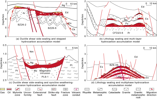
Fig. 10. Hydrocarbon accumulation models of composite buried-hill reservoirs in the offshore Bohai Sea Bay Basin. Ar—Archean; Pt—Proterozoic; Pz—Paleozoic; Mz—Mesozoic; Ek—Kongdian Fm.; Es—Shahejie Fm.; Ed—Dongying Fm.; Ng—Guantao Fm.; Nm—Minghuazhen Fm. |
Ductile shear side-sealing and stepped hydrocarbon accumulation model. Buried hills are extensively connected to mature and overpressured source rocks, and ductile shear mylonite zones divide the buried hills into multiple stepped reservoirs with varying OWCs. A typical example is the BZ26-6 oilfield (Fig. 10a ).
Lithology sealing and multilayer hydrocarbon accumulation model. Thick and tight Mesozoic intervals and Paleogene mudstones are high-quality seals. Although the underlying Paleozoic and Archean hydrocarbon windows are small, hydrocarbon accumulation may have occurred in multiple layers under favorable conditions for nearby source rocks and high hydrocarbon charging pressures. A typical example is the CFD23-6 oilfield (Fig. 10b ).
Ductile shear side-sealing and syncline weathering-erosion hydrocarbon accumulation model. Thick and permeable pore‒fracture zones in the syncline structure are advantageous pathways for hydrocarbon migration. The ductile shear belts are lateral seals. A typical example is the PL9-1 oilfield (Fig. 10c ).
Lithology sealing and multiphase hydrocarbon accumulation model. With favorable conditions near sources and overpressure, hydrocarbons preferentially accumulate in acidic volcanic reservoirs with high porosity and permeability. A typical example is the BZ8-3S oil and gas field (Fig. 10d ).
5. Exploration achievements and future targets
5.1. Exploration achievements
Since 2015, deep to ultra-deep composite buried-hill reservoirs, such as BZ13-2, CFD2-2, BZ 26-6 and BZ8-3S, have been discovered in the offshore Bohai Sea Bay Basin, with cumulative reserves exceeding 400 million tons in the middle and inner belts in the Bozhong Sag.
The BZ26-6 buried hill is a composite buried hill with two structural layers, which is located in the western segment of the Bonan Low Uplift and is sandwiched by the Bozhong Sag and the Huanghekou Sag. The earliest well, BZ26-6-A, drilled at a structural high, encountered an OWC, but the reservoir above the OWC was small. The buried hill is nearly east‒west and is divided into multiple independent structural highs by northeast‒southwest compressional strike‒slip faults and ductile shear mylonite zones (Fig. 9 ). In particular, the low-lying structural high is located in the overlap of the Yanshanian and Himalayan movements and adjacent to the major strike-slip fault zone. Porously fractured reservoirs are good, and thick cap rock is more favorable for hydrocarbon accumulation. In 2022, Well BZ26-6-B was drilled at a secondary structural high. The oil pay interpreted was over 300 m, and the oil production tested was nearly 330 m³/d. The reservoir scale was enlarged by nearly four times (Fig. 10a ).
The BZ8-3S buried hill is a composite buried hill located in the Bozhong Sag and has three structural layers below 5 000 m. After nothing was discovered in the BZ8-4 buried hill, the higher BZ8-3S buried hill located in the same structural belt was considered unable to accumulate oil and gas. However, a seismic survey revealed that the BZ8-3S buried hill featured seismic facies similar to a “Fuji-type” volcano, so it is possible to develop acidic volcanic rocks. The buried hill is also located in a fracture zone affected by both the Yanshanian and the Himalayan movements. It is predicted that the top of a buried hill may contain fractured reservoirs. Additionally, with a cap layer 700 m thick (more than BZ8-4 by 300 m) and a pressure coefficient greater than 1.4, BZ8-3 has better conditions for oil and gas preservation, so it may be a favorable reservoir. A drilling plan was implemented from 2023-2024, and Well BZ8-3S-C exhibited high-yield oil and gas flows at 1 300 m3/d of oil equivalent. It is the largest Mesozoic volcanic oil and gas field in the offshore Bohai Sea Bay Basin (Fig. 10d ).
The successful exploration of BZ 26-6 and BZ 8-3S buried hills increased oil and gas reserves in the Bohai Sea Bay Basin and led to a profound change in the concept of buried hill exploration from the traditional “finding high points” to a more scientific and composite approach.
5.2. Future exploration
On the basis of the latest research findings from the exploration of deep to ultra-deep composite buried hills in the offshore Bohai Sea Bay Basin, two exploration targets are proposed for the Bozhong Sag: (1) the interior of the deep to ultra-deep composite buried hills in the middle belt and (2) the multiphase volcanic structures in the composite buried hills in the inner belt.
Interior buried hills explore the middle belt. Previous exploration in the middle belt focused on the unconformity at the top of the buried hills revealed oilfields such as BZ13-2 and CFD 2-2. Recent research revealed that composite buried hills with dual Archean-Paleozoic and Archean-Mesozoic structures in the middle belt also present excellent reservoir-forming conditions in their interiors. For example, the CFD23-6 and JZ25-3 structures are favorable for hydrocarbon accumulation because they are near sources, benefit from overpressure charging, and have abundant pore‒fracture zones, composite buried hill traps and thick cap rocks (Figs. 1 and 2 ).
Multiphase volcanic structures in composite buried hills in the inner belt: Mesozoic volcanic rocks are widely distributed in the Bohai Sea area. Although volcanic structures such as 428 W, QHD 30-1, CFD12-6, and BZ22-2 have been discovered in the outer and middle belts, exploration in the inner belt is not satisfactory. Research has revealed that the upper volcanic edifices of the composite buried hills in the inner belt, such as BZ8-3S/E, LK7-1, CFD35-6, and BZ16-1, underwent complex multistage volcanic eruptions and double-episode destruction and alteration, resulting in good reservoirs. Covered by thick overpressure cap/source rocks, reservoirs benefit from near-source charging, and the fracture-pore zones in rhyolite/andesite may have multistage and multicycle oil‒water systems. A breakthrough may be possible in ultra-deep reservoirs (Figs. 1 and 2 ).
6. Conclusions
The large-scale deep to ultra-deep composite buried hills in the Bohai Sea area present unique features related to orogenesis, reservoir development and hydrocarbon accumulation.
Orogenesis. Double-episode craton destruction is the primary tectonic factor for the development of deep to ultra-deep composite buried hills in the offshore Bohai Sea Bay Basin. This destruction caused multiple cycles of extensional tilting and compressive uplifting and resulted in composite buried hills. The joint effects of double-episode destruction and the Tanlu Fault activity allowed the subsidence center to migrate from the basin edge to the Bozhong Sag and constructed two major composite buried hill zones in the middle and inner belts. They are good places for hydrocarbon accumulation.
Reservoir development. The composite buried-hill reservoirs were influenced by the double-episode destruction that took place with the Yanshanian and Himalayan movements, which induced pore-fracture zones beneath the weathering crust, although the Mesozoic formations in the middle and inner belts did not experience Indosinian movement.
Hydrocarbon accumulation. Several differential hydrocarbon accumulation models have been established, revealing the unique advantages of hydrocarbon accumulation in the inner belt and interior. These areas not only have favorable source, overpressure charging and pore-fracture zone conditions but also favorable preservation conditions, including isolators and thick cap rocks. All these favorable conditions constitute a superior hydrocarbon accumulation environment. These findings broke through the previous idea that low-lying and interior parts of buried hills are difficult for large oil fields and promoted a profound shift in exploration strategies from “exploring and drilling tectonic highs” to three-dimensional exploration of composite buried hills.
This study is helpful for guiding the exploration and evaluation of large composite buried-hill oilfields such as BZ13-2, CFD2-2, BZ26-6 and BZ8-3S and proposes that the deep to ultra-deep composite buried hills in the middle belt and the multistage volcanic structures in the inner belt are important areas for future exploration, revealing the direction for sustainable growth in oil and gas reserves in the offshore Bohai Sea Bay Basin.