

Introduction
The foreland thrust/fold-thrust belt, lying at the junction of an orogenic belt and a basin, has been a dominant area of petroleum exploration and development due to its abundant resources. The latest breakthroughs or progress made in foreland thrust/fold-thrust belt exploration in Kuqa and southwest Tarim, the south margin of Junggar Basin, and western Sichuan Basin of China demonstrated the promising prospects for petroleum exploration in foreland thrust/fold-thrust belts [1⇓⇓⇓⇓-6].
The Kuqa foreland basin is a Mesozoic-Cenozoic rejuvenated foreland basin undergoing multi-phase tectonic reworking [3]. Within 54 oil and gas fields/reservoirs that constitute two large gas provinces with reserves of trillion cubic meters, i.e. Kela-Keshen and Bozi-Dabei, the gas and oil initially in place are estimated to be 2×10¹² m3 and 1×10⁸ t, respectively, most of which originated from the Jurassic source rocks instead of the Triassic source rocks [1]. The Triassic source rocks generated 60% of total hydrocarbons in the Kuqa foreland basin as per the national oil and gas resources assessment accomplished in the 13th Five-Year Plan of China. It is necessary to explain why there is a great contrast between hydrocarbon generation by Triassic source rocks and oil and gas discoveries.
According to preceding research findings of Triassic orogenesis in Tianshan orogenic belt, structural and sedimentary features, and reservoir forming and distribution in the foreland basin [7⇓-9], the Kuqa Depression was deposited with a sedimentary system comprising braided river deltas and lakes mainly and thick alluvial fan deposits in the north piedmont zone in the northward subduction process of the Tethys Ocean in the Triassic[10⇓-12]. However, in the outcrop survey, the eastern depression was revealed to lack in coarse-grained clastic deposits, as shown by the Yangxia outcrop section. Drilling data from some wells (e.g. SM1) showed intense denudation at the late stage in the Uqturpan sag, where there are no interbedded sandstones and mudstones in the Taliqike Formation, which is contradict preceding conclusions. Preceding studies focused on the middle part of the north structural belt in the Kuqa Depression instead of the overall sedimentation in the Triassic period. As per the latest researches, the Kuqa Depression features episodic thrusting activities, which had a strong impact on sedimentary formations and led to complicated sequence stacking and sedimentary filling history [13-14]. On the other hand, seismic data quality is poor due to large buried depth of the Triassic in the depression, thus it is hard to establish accurate stratigraphic subdivision, sedimentary evolution, and the distribution of source rocks in the Triassic of Kuqa Depression.
Our study used the outcrop data of the Kuqa River (KCH), Taliqike (TLQK), Kelasu River (KLSH), Awate (AWT), Yangxia (YX), and Meath Braque (MSBLK) sections, log data of wells KQ1, YL2, YN2 and ST1, and 2D/3D seismic data to establish the tectonic-sequence stratigraphic framework for the Kuqa foreland basin, discuss the response characteristics of episodic thrust structures with sequences and sedimentary evolution, and corresponding source-reservoir assemblages in the Triassic. Our research results may be referential for petroleum exploration in deep thrust/fold-thrust belts in the Kuqa foreland basin.
1. Geologic setting
The Tarim Basin is a large composite petroliferous basin with multi-cycle superposition owing to the influence of the Tianshan Mountains on the north and the Kunlun Mountains on the south [10]. The Kuqa Depression in the northern Tarim Basin is an important component of this large composite superposed basin. It is in the immediate vicinity of the Tianshan Mountains on the north and the Tabei uplift on the south, and extends from Wensu on the west to Korla on the east. The depression is 450 km long in the east-west direction and 20-60 km wide in the north-south direction (Fig. 1 ).
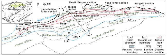
Fig. 1. Tectonic units in the Kuqa Depression. |
The South Tianshan Ocean in the northern Tarim Basin went through multi-phase opening-closing tectonic cycles in the Paleozoic, when the Kuqa Depression lied at the north margin of the Tarim craton [15]. The South Tianshan Ocean was eventually closed at the end of the Permian, when the Tarim plate collided with the Yili-Middle Tianshan massif to form the Kuqa foreland basin on the south of the South Tianshan orogenic belt. The area on the north of the Uqturpan sag- Kelasu structural belt-Tugalming structural belt is the fore deep of the Kuqa foreland basin, and the Tabei uplift on the south is the front uplifted zone of the basin [16].
The Triassic in the Kuqa foreland basin is divided into a lower series (Ehuobulake Formation), a middle series (Karamay Formation), and an upper series (Huangshanjie and Taliqike formations) from the bottom up (Fig. 2 ). Owing to the sustained compression by the South Tianshan intracontinental orogenesis in the Triassic, the Kuqa Depression was deposited with Triassic formations of 2 300 m thick at most [17]. The Ehuobulake Formation was extensively settled with alluvial fan and braided river delta deposits of 100-600 m thick, which comprise two packages of grayish green mudstones and sandstones and two packages of purplish red interbedded sandstones, conglomerates, and mudstones with grayish brown conglomerates at the bottom. The Karamay Formation of 200-500 m thick was deposited with interbedded grayish green sandy conglomerates and mudstones of varied thickness. The Huangshanjie Formation of 170-600 m thick was deposited with a fluvial-lacustrine system composed of two upward-fining sedimentary cycles, i.e. two- package hard sediments and two-package soft sediments [11]. The Taliqike Formation of 100-450 m thick was mainly deposited with interbedded sandstones and mudstones.
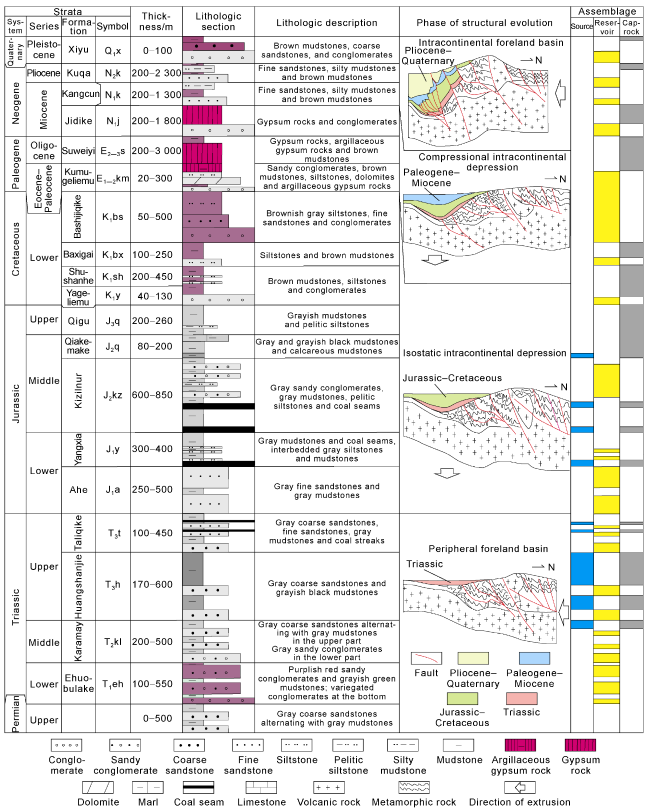
Fig. 2. Composite stratigraphic column of the Kuqa Depression. |
2. Tectonic sequence stratigraphy
2.1. Sequence boundary identification
Tectonic sequence boundaries are regional unconformities or corresponding conformities, which were generated by the dual effects of tectonic movements and sudden base level drop [18]. They are also the basis of sequence boundary identification and stratigraphic subdivision using outcrop, well and seismic data.
The Triassic outcrops in the Kuqa foreland basin have good quality. We used outcrop data and well data, together with 2D seismic surveys across the basin and 3D seismic surveys in major prospects, to perform stratigraphic boundary identification as well as sequence subdivision and correlation. Bed boundaries, e.g. sedimentary transition surface, basal conglomerate bed or erosional surface, truncation and overlap, were taken as the constraints. The Triassic in the Kuqa foreland basin was identified with 5 secondary tectonic sequence boundaries: Ehuobulake Formation bottom, Ehuobulake Formation top, Karamay Formation top, Huangshanjie Formation top and Taliqike Formation top, from the bottom up.
Ehuobulake bottom is a regional unconformity between the Triassic and underlying formations (Fig. 3a , 3b). At the end of the Permian, the Proterozoic-Permian formations cropped out extensively in central and southern Kuqa foreland basin due to tectonic uplift. For example, the Proterozoic metamorphic rocks emerged in Tugalming area and Uqturpan sag. The metamorphic pelitic siltstones, with a lot of sericite, were revealed to underlie the bottom boundary of the Ehuobulake Formation and be in unconformable contact with the Triassic strata in the Taliqike and Kapushaliang River sections (Fig. 4a -4c). Truncation could be observed on seismic section between the Triassic and underlying formations. However, the Triassic is in conformable contact with underlying formations in the area from Kelasu River to Kuqa River.
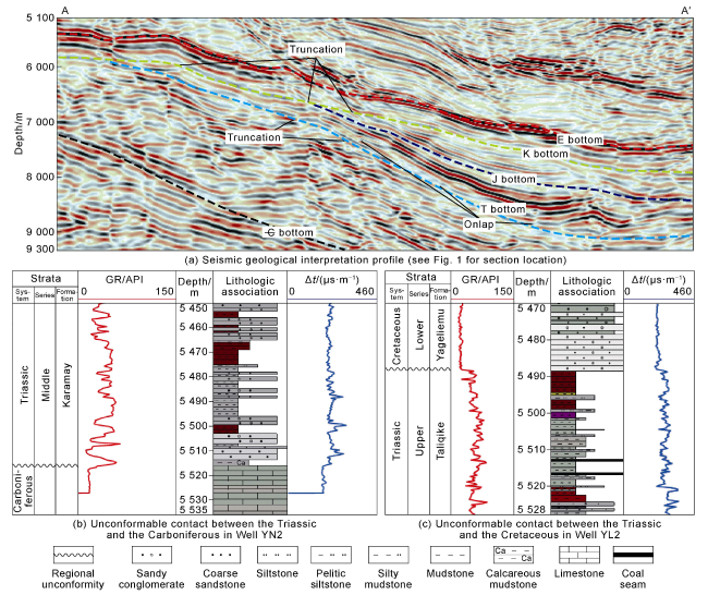
Fig. 3. Seismic profile and logging features at Triassic boundaries in the Kuqa Depression (GR—gamma ray; Δt—interval transit time). |
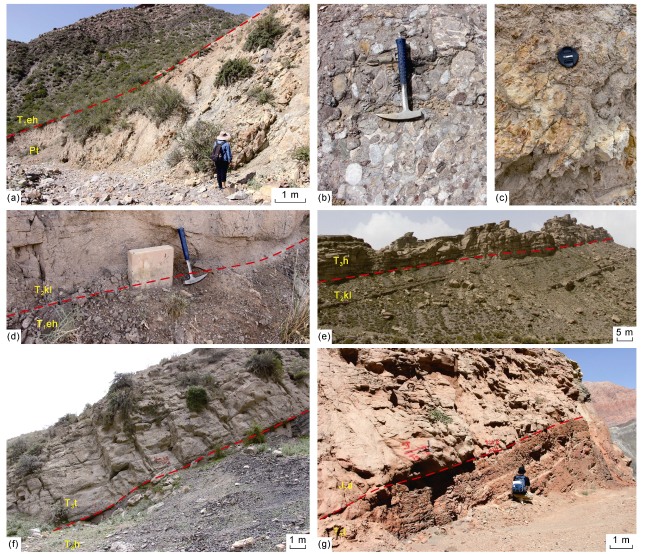
Fig. 4. Triassic boundary features of geological section in the Kuqa Depression. (a) Unconformable contact between the conglomerates at the bottom of the Triassic Ehuobulake Formation and the metamorphic rocks at the top of the Proterozoic, Taliqike section; (b) Variegated conglomerates at the bottom of the Triassic Ehuobulake Formation, well rounded, Taliqike section; (c) Yellowish green metamorphic rocks at the top of the Proterozoic, Taliqike section; (d) Abrupt lithologic change from the sandy conglomerates at the bottom of the Triassic Karamay Formation to the silty mudstones at the top of the Ehuobulake Formation, Kuqa River section; (e) Abrupt lithologic change from the sandstones at the bottom of the Triassic Huangshanjie Formation to the grayish green mudstones at the top of the Karamay Formation, Kuqa River section; (f) Abrupt lithologic change from the sandy conglomerates at the bottom of the Triassic Taliqike Formation to the black mudstones at the top of the Huangshanjie Formation, Awate section; (g) Abrupt lithologic change from the thick sandstones at the bottom of the Jurassic Ahe Formation and the brown pelitic siltstones at the top of the Triassic Taliqike Formation, Yangxia section. |
Ehuobulake Formation top to Huangshanjie Formation top are the top boundaries of the Ehuobulake, Karamay and Huangshanjie formations, respectively. In the outcrop sections in the northern depression, the boundaries are the erosional unconformable surfaces produced by intensive erosion of underlying fine-grained clastic rocks by coarse-grained clastic rocks (Fig. 4d -4e). Truncation-related unconformities also occur at the south boundary of the basin.
Taliqike top is a regional unconformity between the Triassic and overlying formations. In the Uqturpan sag in western Kuqa foreland basin, interbedded sandstones and mudstones in the Taliqike Formation and thick Cretaceous sandy conglomerates turn up respectively below and above Taliqike Formation top, which was shaped as an extensive erosional unconformity with abrupt lithologic change (Fig. 3c ). The stratigraphic gap of the Upper Triassic and the angularly unconformable contact between the Triassic and overlying formations in the southern basin indicate intense tectonic activities at the end of the Triassic, which gave rise to the regional unconformity. Truncation could be clearly observed between the overlying and underlying formations above and below Taliqike Formation top on seismic section.
Based on secondary tectonic sequence boundary identification and the analysis of exposure, weathering and erosion, scouring, 7 tertiary sequence boundaries, SB1-SB7, were recognized within the Triassic (Fig. 5 ). It is noted that the interfaces with abrupt lithologic change were considered in determining tertiary sequence boundaries, above which there are thick sandy conglomerates and below which mudstones or silty mudstones. This agrees with the lithologic change characterized using log data.
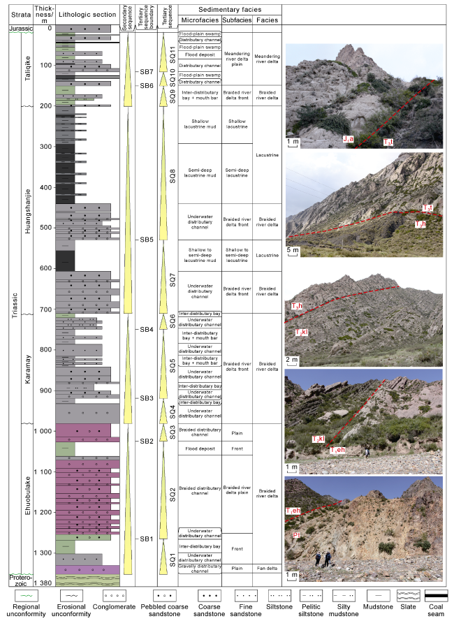
Fig. 5. Composite stratigraphic column of Triassic sequences and sedimentary facies in the Taliqike section of Kuqa Depression (see |
2.2. Sequence stratigraphic features
The episodic thrusting activities in the foreland basin tended to be coupled with sedimentary cycles [11,13 -14]. The episodic thrusting activities in 4 stages, i.e. strong, weakened activities, relaxation and inactive, in the Triassic of the Kuqa foreland basin gave birth to 4 secondary sequences from the bottom up (Fig. 6 ), corresponding to the Ehuobulake, Karamay, Huangshanjie and Taliqike formations, respectively. Each secondary sequence also experienced the similar secondary thrusting process from the strong stage to the relaxed stage. According to the features of episodic thrusting activities, 4 secondary sequences were further divided into 11 tertiary sequences: SQ1-SQ11.
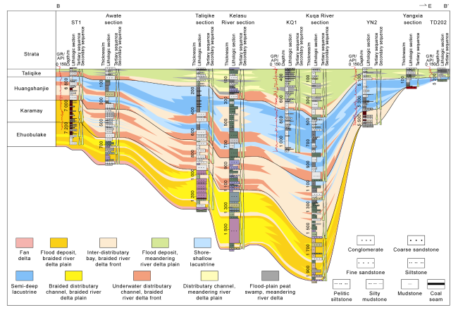
Fig. 6. An east-west correlation section across the Kuqa Depression showing the Triassic stratigraphic sequences and sedimentary facies (see |
The depositional stage of the Ehuobulake Formation has experienced strong thrusting activities, at the bottom of which there are extensive alluvial fan and fan delta deposits. The Kuqa River-Xiaotailan River outcrops were observed with fine-grained to medium-grained conglomerates of 20 m thick at the bottom. This agrees with the conclusion made by Wang et al., who stated that low- grade metamorphic rocks cropped out due to southwest Tianshan orogenesis and uplift in the Early Triassic in accordance with the extremely high spessartine content [18]. Based on the interfaces with abrupt lithologic change and cycle features, this sequence was divided into 3 tertiary sequences (SQ1-SQ3). Regionally, formation thickness reaches the peak in the Kuqa River section and decreases toward the east and west (Fig. 6 ).
The depositional stage of the Karamay Formation has experienced weakened thrusting activities, with the change of sporopollen assemblage from fern spores to coniferales pollen and a change from arid climate to semiarid-semihumid climate [19]. Granites occurred more extensively in the Tianshan orogenic belt, and more high-grade metamorphic rocks cropped out. Compared with the Ehuobulake Formation, the Karamay Formation was deposited with finer-grained material, and the subsiding center moved from the Kelasu River toward the Kuqa River. The formation thickness was estimated to reach 550 m in the Kuqa River section [20]. Controlled by secondary episodic thrusting activities, the Karamay Formation was further divided into 3 tertiary sequences: SQ4-SQ6 (Fig. 5 ). Laterally, the Karamay Formation covers more area than the Ehuobulake Formation and, toward the east, overlaps the area on the west of the Yangxia section. Therefore, the formation thickness decreases toward the east (Fig. 6 ).
At the depositional stage of the Huangshanjie Formation with relaxed thrusting activities and insufficient sedimentary sources, the basin was mainly filled with fine-grained sediments with more extensive distribution than in other periods. In view of the second-episode secondary thrusting activities, the Huangshanjie Formation was subdivided into 2 tertiary sequences: SQ7 and SQ8 with two upward-fining normal cycles, which consist of two-package hard sediments and two-package soft sediments [21] (Fig. 5 ). The formation thickness reaches the peak in the Kuqa River section and decreases toward the east and west (Fig. 6 ).
The depositional stage of the Taliqike Formation has experienced inactive tectonic compression featured by small formation thickness and coarse and fine sandstones.Flourishing pinaceae, podocarpus and osmundaceae, combined with warm humid subtropical climate made a great contribution to well-developed coal-bearing formations in this period [19]. The formation thickness reaches the peak of 350 m in the Kuqa River section and decreases toward the east and west (Fig. 6 ). Due to the stratigraphic break caused by the tectonic uplift at the end of the Jurassic, the Taliqike Formation is in unconformable contact with the overlying Cretaceous in the Uqturpan sag (Fig. 3 ). In view of secondary episodic thrusting activities, the Taliqike Formation was subdivided into 3 tertiary sequences: SQ9-SQ11 (Fig. 5 ).
3. Episodic thrusting activities and sequence-sedimentary responses
3.1. Episodic thrusting activities and sequence responses
Episodic thrusting activities had a unified impact on the pattern of stratigraphic superposition [22], and accommodation space also showed episodic change in the evolutionary process of the Kuqa foreland basin in the Triassic during stages of strong to weakened episodic thrusting activities. In the stage of strong tectonic compression (the depositional stage of the Ehuobulake Formation), the basin was greatly flexed and subsided. Owing to sufficient sediment supply and the short time of duration, the basin with small accommodation space was filled with coarse-grained sediments. In the stage of weakened tectonic compression (the depositional stage of the Karamay Formation), decreased sediment supply and slow lake level rise in a long period of time led to an increase in accommodation space with medium- to coarse-grained sediments. In the stage of relaxed tectonic compression (the depositional stage of the Huangshanjie Formation), a further decrease in sediment supply and rapid lake level rise in a long period of time gave rise to the largest accommodation space, in which fine-grained sediments were deposited. In the stage of inactive episodic thrusting (the depositional stage of the Taliqike Formation) with small surface relief, accommodation space was shrunk due to fast lake level drop in a short period of time. The formation thickness is small or nearly zero, and rocks mainly involve sandstones alternating with mudstones [11] (Fig. 7 ).
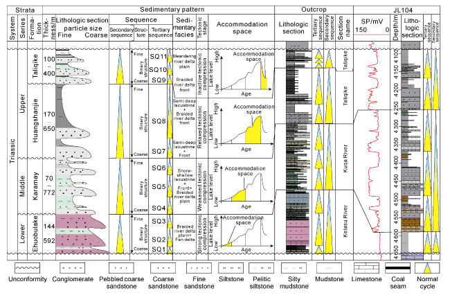
Fig. 7. Relationship between tectonic cycles and sequence structure in the Triassic of the Kuqa Depression (SP— self-potential). |
On the whole, owing to the episodic thrusting activities, the lithologic association in each secondary sequence exhibits a distinct binary structure, which is characterized by a depositional pattern with coarse-grained sediments in the lower part and fine-grained sediments in the upper part. Coarse-grained clastic rocks in the lower part occurred at the early stage of thrusting activities, when sufficient supply of coarse-grained clastics led to thick deposition of sandy conglomerates. Fine-grained clastic rocks in the upper part occurred in the stage of relaxed thrusting activities, when the basin was in a transgressive system in view of deepened lake water [11,13 -14]. The next stage of sedimentary evolution launched at the end of each cycle due to rapid lake level drop.
Despite the comprehensive effects of paleosources, paleoclimates and paleostructures, tertiary sequences against the structural setting with episodic thrusting activities also show binary structures. Regional tectonic activities in the South Tianshan Mountains generated similar sequence patterns, which could be correlated between the Kuqa foreland basin and the Tabei uplift. We compared outcrops from Kuqa depression with well JL104 from Tabei uplift lithologic sections at well sites and found that SQ1 basal conglomerates were lost in the Tabei uplift, which is the consequence of intense uplift and denudation of the foreland basin front due to the tectonic compression caused by thrusting activities at the initial stage. Therefore, no coarse-grained clastic rocks were settled in this period (Fig. 7 ). The sedimentary formations in Kuqa and Tabei feature similar binary structures in the phase of SQ4-SQ6, but the grain size and scale of coarse-grained clastic rocks of SQ4 are greater than those of SQ5-SQ6. The Karamay Formation shows a normal cycle on the whole. SQ7 and SQ8 are tertiary sequences with normal cycles, and the Huangshanjie Formation shows a normal cycle on the whole. Three tertiary sequences of SQ9-SQ11, which all present normal cycles, are relatively thin due to tectonic stress relief, leading to the rebound of the flexed deformed basement in a short period of geologic time. In summary, binary structures produced by the episodic thrusting activities in the foreland basin could be used as reference for the classification and correlation of secondary and tertiary sequences.
3.2. Episodic thrusting activities and sedimentary responses
The Kuqa foreland basin is similar in the mechanisms of tectonic subsidence and evolution to other foreland basins in China and abroad [2,23]. Previous studies showed that with enhanced tectonic activities in the foreland basin, sediments from overthrust and foredeep uplifted zones to depression zones manifest the change in grain size from coarse-grained alluvial fan deposits to lacustrine deposits. The latest studies have indicated that owing to the joint influences of basin properties, orogenesis related to thrusting activities and sedimentary sources, together with multi-phase variable-order tectonic activities, both the secondary and the tertiary sequences in the Triassic of the Kuqa foreland basin demonstrate lithologic associations with binary structures.
(1) In the stage of strong episodic thrusting activities, corresponding to the depositional stage of the Ehuobulake Formation, ample sediment supply and small accommodation space led to a sedimentary system mainly composed of alluvial fans and fan deltas. For example, the Kuqa River section in the northern Kuqa Basin was deposited with thick reddish brown medium- to fine-grained conglomerates of fan delta facies, with moderately to perfectly rounded, oriented pebbles and massive bedding. (2) In the stage of weakened episodic thrusting activities, corresponding to the depositional stage of the Karamay Formation, decreasing sediment supply and increasing accommodation space owing to lake level rise resulted in a sedimentary system mainly composed of braided river deltas and lacustrine deposits. Braided distributary channels were filled with reddish brown pebbled coarse sandstones and coarse sandstones, with moderately to perfectly rounded pebbles, poorly rounded and oriented clastic particles, and trough and wedge-like cross-beddings. In outcrop sections, braided distributary channels could be observed with multi-package fine-grained conglomerates with multi-phase normal grading in the vertical direction, indicating the vertical stacking of multi-channel sands. Lacustrine deposits dominated by shore-shallow lacustrine deposits are distributed locally. (3) In the stage of relaxed episodic thrusting activities, corresponding to the depositional stage of the Huangshanjie Formation, obviously insufficient sediment supply and the largest accommodation space gave rise to a fine-grained sedimentary system composed of braided river delta fronts and lacustrine deposits (Fig. 8 ). Braided river delta fronts were deposited with gray medium to fine sandstones with a few pebbles only appearing at the bottom. Clastic particles in sandstones were moderately rounded, most of which were transported by saltation and some of which by rolling. Sedimentary structures include trough and tabular cross-beddings, and massive bedding. The lake area was settled with thick black mudstones of shallow to semi-deep lacustrine facies, in which there are horizontally laminae. In general, the stage of relaxed episodic thrusting activities features fine-grained sedimentation, during which dominant source rocks developed in the foreland basin. In the stage of inactive episodic thrusting, corresponding to the depositional stage of the Taliqike Formation, the basin was mainly filled with meandering river and limnetic sediments due to rapidly decreasing accommodation space. Distributary channels in the meandering river delta plain were deposited with gray siltstones and fine sandstones with smaller grain size than in braided distributary channels. Clastic particles were poorly rounded, most of which were transported by saltation and suspension. Trough and tabular cross-beddings were well developed. The limnetic area was mainly settled with grayish black mudstones with carbonaceous fragments, pelitic siltstones, and coals of peat swamp microfacies. Coal seams are generally smaller than 1 m thick.
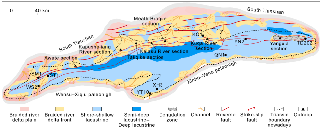
Fig. 8. Sedimentary facies in the Triassic Huangshanjie Formation of the Kuqa Depression. |
Sedimentary facies in tertiary sequences also correlate with episodic thrusting activities. Owing to the secondary episodic thrusting activities, the lithologic association in each tertiary sequence features an upward-fining binary structure, with coarse-grained sediments dominating in the stage of relatively strong thrusting activities and fine-grained sediments in the stage of relatively relaxed thrusting activities. On the whole, SQ1 was mainly deposited with fan deltas, and SQ2-SQ3 with braided river delta plain-front deposits. As the lake level rose, SQ4 to SQ6 underwent a transition from braided river delta plain deposition to front deposition, SQ7-SQ8 from braided river delta-front deposition to shore-shallow lacustrine and semi-deep lacustrine deposition, and SQ9-SQ11 from braided river delta-front deposition to meandering river delta flood-plain deposition.
SQ7 differs from SQ8 in the Huangshanjie Formation. Due to the impact of strong to weakened secondary episodic thrusting activities, both SQ7 and SQ8 were deposited with thick sandy conglomerates and coarse sandstones at the lower part, but sandstone thickness and grain size in SQ7 are much greater than in SQ8 (Fig. 6 ), which indicates stronger tectonic activities in SQ7 sedimentary period than in SQ8 sedimentary period. SQ7 and SQ8 were deposited with thick mudstones in the stages of relaxed and inactive thrusting, and black mudstones in SQ7 are much thinner than in SQ8. Laterally unstable black mudstones in SQ7 turned up locally in the semi-deep lacustrine zone (Fig. 6 ) in a short period of time. In contrast, SQ8 black mudstones in the Taliqike section reach 140 m thick and extend steadily in the lateral direction, at the depositional stage of which a wide lake basin was shaped with the largest lake level. These differences indicate intense secondary episodic thrusting activities within a short period of time in SQ7 and relatively weak thrusting activities within a long period of time in SQ8.
The enhanced uplift of the South Tianshan Mountains from north to south dominated the vertical evolution of sedimentary sequences in the basin [22]. On the whole, the Kuqa Depression in the Triassic was deposited with a system changing from fan delta, braided river delta plain, braided river delta front, shore-shallow lacustrine, semi-deep lacustrine, shore-shallow lacustrine, braided river delta front, to meandering river delta plain. Such a distribution pattern corresponds to the complete evolutionary process from strong to inactive thrusting in the foreland basin.
4. Geologic significance of episodic thrusting activities
4.1. Control of episodic thrusting activities on Triassic source rocks
4.1.1. Relaxed thrusting favorable for lacustrine source rocks deposition
Episodic thrust tectonic cycles have a great impact on stratigraphic sequences and sedimentary evolution. Dominant source rocks in the Kuqa foreland basin turned up in the stage of relaxed episodic thrusting activities. Lacustrine argillaceous source rocks in the Triassic Huangshanjie Formation vertically occurred in the upper part of the tertiary sequence. As per outcrop observation, there are two-package lacustrine black argillaceous source rocks of large thickness in SQ7-SQ8. Laterally bounded by the Taliqike section, the Huangshanjie source rocks thin out toward the east and west. The source rock thickness is over 180 m near the Taliqike section, 120 m in the Kapushaliang River section to the west, 70 m in Well SM1, 55 m in the Yangxia sag to the east, and only 44 m near Well YN2 (Fig. 6 ). Source rocks are thin in the north piedmont zone and 77 m in the Kuqa River section. Source rocks also developed in the inactivity stage of thrusting, taking coal-measure source rocks in the Taliqike Formation as an example, the thickness is small. As per core observation, source rocks are 12 m thick in Well YN2.
4.1.2. Thrusting activities leading to the stacking of source rocks in the hanging and foot walls
The fault system shaped by compressional thrusting activities dominated the occurrence and distribution of source rocks, which are mainly fine-grained sediments. Due to episodic thrusting activities, soft formations went through multi-phase thrusting and napping, easily leading to the stacking of thrust nappes with source rocks. Field observation showed great thickness differences in the Huangshanjie and Taliqike source rocks in different outcrops, which may be attributed to the ancient landform and overthrust nappe structures generated by the intense thrusting activities in the Ehuobulake Formation. Large formation thickness in the foot walls in thrust belts is revealed by seismic data interpretation, specifically large syndepositional thickness in the foot walls caused by the growth faults in the early, relaxed stage and plastically thickened mudstones in the foot walls caused by late strong thrusting (Fig. 9 ), may be related to the stacking of source rocks in soft formations after multi-phase thrusting and napping. Based on regional 2D seismic data and 3D seismic data of major prospects as well as outcrop and well data, we mapped the Triassic source rocks in the Kuqa foreland basin. There are four rows of overthrust belts in the basin. After multi-phase thrusting and napping, source rocks in the foot walls may be thickened to 560 m at most (Fig. 10 ). The distribution trend of thick Triassic source rocks in the north and thin in the south may correspond to the pattern of intense thrusting activities in the north and weak in the south.
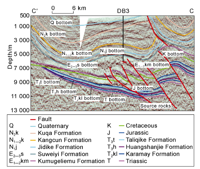
Fig. 9. Seismic section across Well DB3 in the Kuqa Depression (see |

Fig. 10. Thickness map of Triassic source rocks in the Kuqa Depression. |
According to the latest study of thrusting distance of overthrust faults at the basin-mountain junction based on the control of thrusting stage and intensity on the distribution of source rocks, the thrusting distance in the piedmont zone of Kuqa was estimated to be 10-15 km in general and may reach 30 km at most. If source rocks overlapped by mountains are taken into account, the size of Triassic source rocks in the Kuqa foreland basin will greatly increase.
4.2. Control of episodic thrusting activities on Triassic hydrocarbon accumulation
Episodic thrusting activities dominated the development and distribution of source-reservoir-caprock assemblages. Coarse-grained clastic rocks forming in the stages of strong and weakened thrust compression may function as important reservoir rocks. According to outcrop and well data, there are extensive braided river-meandering river delta sands with good reservoir properties in the Triassic, the porosities of which are 6.51%-15.32% with the average of 9.73%. Source rocks occurred in the stages of relaxed and inactive thrusting. Lacustrine argillaceous source rocks in the Huangshanjie Formation deposited in the stage of relaxed thrusting activities are 100-500 m thick and cover an area of 18 800 km2. This package of source rocks, with TOC of 1.3%-7.1%, H-C atomic ratio of 0.4-0.8, O-C atomic ratio of 0.35-1.10, and Type-II2 kerogens in the majority, is the dominant source contributor in the Kuqa foreland basin. Oil-gas and source-rock correlation showed that natural gas recently discovered in the Jurassic Ahe Formation, Dibei area, originated from the Triassic source rocks [24]. In addition to coal-measure source rocks, the Triassic capping beds also formed in the stage of inactive thrusting.
The Triassic lacustrine source rocks in the Kuqa Depression were mature enough to generate hydrocarbon at the depositional stage of the Jidike Formation (23 Ma) and reached the peak of hydrocarbon generation at the stage of the Neogene Kangcun Formation (5-12 Ma) [24]. The episodic thrust tectonic cycles in the Triassic dominated sedimentary evolution and source-reservoir configuration, in addition to deep stratigraphic sequences. Consequently, multi-type primary hydrocarbon reservoirs could form before the Himalayan orogeny [25-26]. Lithologic hydrocarbon reservoirs may occur inside the Huangshanjie Formation, and structural-lithologic gas reservoirs may occur in the reverse drag structures forming in the hanging walls of early reverse faults.
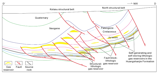
Primary hydrocarbon reservoirs were adjusted by the thrusting activities taking place in the Himalayan, and episodic thrusting activities dominated the occurrence and distribution of gas reservoirs. As shown on regional 2D seismic sections, deep structures in the Triassic of the Kuqa foreland basin are relatively complete and large, which means that there may be large oil and gas fields provided that source-reservoir configuration is promising. As per the source-reservoir configuration nowadays and accumulation conditions, lacustrine source rocks and braided river delta front sands in the Huangshanjie Formation as well as coal-measure source rocks and meandering river delta sands in the Taliqike Formation may constitute self-generating and self-storing lithologic gas reservoirs. Lacustrine source rocks in the Huangshanjie Formation and sandstones in the Taliqike Formation, particularly in the Tugalming anticlinal zone, may constitute structural-lithologic gas reservoirs with an assemblage pattern of lower source rocks and upper reservoir rocks. Source rocks in the foot walls and the structural highs in the thrust of hanging walls may constitute fault block-lithologic gas reservoirs (Fig. 11 ).
Fig. 11. Gas reservoir enrichment pattern in the Kuqa Depression (see |
5. Conclusions
There is a coupled relationship between episodic thrusting activities with stratigraphic sequences and sedimentary filling in the foreland basin. The Kuqa foreland basin underwent the complete stages of strong, weakened activities, relaxation and inactivity of episodic thrusting, corresponding to 4 secondary sequences with upward-fining binary structures in the Triassic Ehuobulake, Karamay, Huangshanjie and Taliqike formations, respectively. Dominated by secondary episodic thrusting activities, each of secondary sequences was deposited with similar upward-fining binary structures, and can be subdivided into 11 tertiary sequences.
Episodic thrusting activities controlled sedimentary system evolution in the Kuqa foreland basin. As a result, the sedimentation evolved from fan delta, braided river delta, lake, to meandering river delta from the bottom up. Coarse-grained sediments, as reservoir rocks in the basin, predominated in the stages of strong to relaxed episodic thrusting activities. Fine-grained sediments, as source rocks in the basin, predominated in the stages of relaxation and inactivity of episodic thrusting.
The fault system caused by compressional thrusting has a great impact on the occurrence and distribution of source rocks. Controlled by the intensity and stages of episodic thrust activity, the nearly EW trending thrust fault significantly thickened the footwall source rock during the Huangshanjie Formation, becoming the development center of Triassic source rock, and experienced multiple overthrust nappes in the soft stratum of the source rock, showing “stacked style” distribution, which led to greatly thickened source rocks in the foot walls of faults generated by thrusting. Thus, these areas became the source center of hydrocarbon generation in the Triassic.
Owing to the thrusting activities from the Indosinian to the Himalayan, deep strata in the Kuqa may have promising conditions to form large-scale hydrocarbon reservoirs. According to source-reservoir assemblage and accumulation conditions, there may be multi-type hydrocarbon reservoirs in the Triassic in foreland thrust belts, including self-generating and self-storing reservoirs, structural-lithologic reservoirs with lower source rocks and upper reservoir rocks, fault block-lithologic reservoirs and stratigraphic unconformable reservoirs.