

Introduction
The Middle Triassic Leikoupo Formation is the carbonate strata with the shallowest buried depth for hydrocarbon exploration in the Sichuan Basin. The gas fields such as Moxi, Wolonghe, Longgang, Yuanba, Zhongba and Pengzhou have been discovered in over 50 years. Specifically, Moxi and Wolonghe are mainly producing from the first submember of the first member of Leikoupo Formation (Lei-1-1), and Zhongba from the third susbmember of the third member of Leikoupo Formation (Lei-3-3); both Longgang, Yuanba and Pengzhou are producing from the third submember of the fourth member of Leikoupo Formation (Lei-4-3), with the grain shoal dolostone, microbialite and karst reservoirs, which host the gas reserves of 3 000×108 m3 [1⇓⇓-4].
It has been argued that the tidal flat-epeiric marine platform or rimmed carbonate platform mostly covered the western Sichuan Basin during the depositional period of Lei-4 Member, with the intertidal dolomitic flat, algal shoal and microbialites as the favorable reservoir facies [4]. However, it is found that the evaporates [2-3], tempestites[5-6] and microbialites [7⇓-9] occur in a mutualism system in the Lei-4 Member carbonate platform across the western Sichuan Basin, which has been believed to develop in a depositional framework where the facies zones within the rimmed platform or epeiric marine platform are wide and gentle and change gradually [4]. However, the characteristics of narrow-zoned dramatic facies transition on platform have been found out after further investigation, which is inconsistent with the previous outcome and actually obstructs our understanding on the depositional pattern as well as the prediction of favorable reservoir facies zones for the Lei-4 Member.
Based on the analysis of sedimentology, petrology and well log data as well as the unique lithofacies indicators such as microbialite, gypsum-salt rocks and tempestites in about 400 boreholes and 11 outcrop sections within the western Sichuan Basin, the depositional facies types and the facies transition characteristics in the narrow-zone have been examined and the “ocean-bay-flat” depositional model has been proposed in the Lei-4 Member in this paper. In addition, distribution characteristics and evolutionary process of the bay facies were clarified, and its petroleum geological significance was elucidated, which provide references for the further hydrocarbon exploration in the Lei-4 Member of western Sichuan Basin.
1. Geological setting
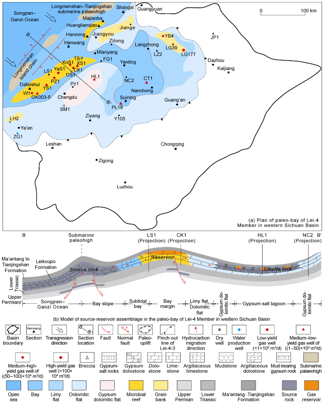
It is demonstrated that the western margin of the upper Yangtze block was a passive continental margin basin on the southeast side of paleo-Tethys near 11° north latitude during the Middle Triassic [10-11]. As the westward scissors-typed collision between South China plate and North China plate has maintained since the Late Permian[12], it presents the tectonic pattern of external compression with internal tension, and the topographic pattern of low-lying east-to-west-oriented configuration within the upper Yangtze block [13-14] with underwater geomorphology of graben and horst alternating along the edge and the allochthonous carbonate slump or debris flow developing in the grabens [14-15]. With the uplift during the early episode of Indosinian Movement at the end of Middle Triassic, Luzhou and Kaijiang paleohighs appeared in the eastern Sichuan area (Fig. 1a ). The cores of the paleohighs are denuded to the Lower Triassic Jialingjiang Formation, with the denudation degree reducing on both sides, and only the Leikoupo Formation in the western Sichuan area remained relatively well-preserved[14⇓-16].
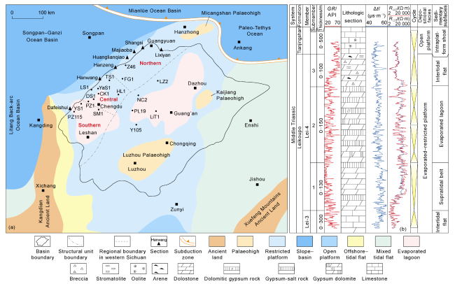
Fig. 1. Depositional facies of Leikoupo Formation (a) and composite stratigraphic column of Lei-4 Member in Well CK1 in western Sichuan Basin and its periphery (b) (modified from references [8,12] ; GR—gamma ray; Δt—interval transit time; RLLD—deep lateral logging resistivity; RLLS—shallow lateral logging resistivity). |
The arid restricted platform-tidal flat occupied the upper Yangtze block in the depositional period of Middle Triassic Leikoupo Formation with multiple sedimentary cycles of carbonates and evaporates [2⇓-4]. According to the lithological and electrical features, the Leikoupo Formation is subdivided into four members, i.e. Lei-1, Lei-2, Lei-3 and Lei-4, from bottom to top, with a total thickness of 0-1 000 m (Fig. 1b ), including 9 submembers. The Lei-4 Member in western Sichuan Basin is mostly composed of gypsum-salt rocks, gypsum dolomite, dolomitic gypsum rock, dolomicrite and microbial carbonates, with a total thickness of 100-300 m [2,4,8], which is subdivided into three submembers, i.e., Lei-4-1, Lei-4-2 and Lei-4-3, from bottom to top. The dolomicrite, gypsum dolomite and gypsum-salt rocks dominate in Lei-4-1, with the gypsum-salt rocks dominating in central to south parts of western Sichuan Basin. The dolomicrite is bordered with the micrite of the Lei-3 Member at bottom and the gypsum-salt rocks of Lei-4-2 at top with a smaller gamma ray and larger electrical resistivity values in the logging curves across the boundaries [4,14]. Lei-4-2 mostly constitutes such evaporates as thick-layered to massive gypsum-salt rocks and gradually change from dolomitic gypsum rock in the upper part into the microbial dolostone of Lei-4-3 with a larger gamma ray and smaller electrical resistivity values at the boundary. In Lei-4-3, the microbial dolostone, microbial limestone and dolomicrite are predominant [4,12]. The dolomicrite of Lei-4-3 turns into limestone across topmost boundary, which is in a conformable contact with the bioclatisc limestone of Middle Triassic Tianjingshan Formation in the northern part but a parallel unconformity contact with the microbial limestone of Upper Triassic Ma’antang Formation in the north-central of western Sichuan Basin and central Sichuan Basin with a larger gamma ray and smaller electrical resistivity values in logging curves [4,12].
2. Depositional facies characteristics of Lei-4 Member and depositional model of bay facies
2.1. Depositional facies indicators
2.1.1. Depositional structures
The depositional structures such as hummocky cross-bedding, scoured base, graded bedding, inverse graded bedding, stromatolitic structure, convolute bedding, collapsed deposits, nodular structure, turbidite and microbial reef have been figured out in the Lei-4 Member within the western Sichuan Basin.
The scoured base and hummocky cross-bedding were mostly formed in the storm depositional environment, and are identified in sections of Hanwang, Majiaoba, Ma’antang as well as Well LS1, with locally graded bedding (Fig. 2a ) and storm rudite (Fig. 2b ), indicating an open deepwater slope environment [5-6]. However, the inverse graded bedding, which is the sedimentary structure with an upward coarser trend in grain size, indicating grain shoal deposit, occurs in the Hanwang and Majiaoba outcrop sections (Fig. 2c ).
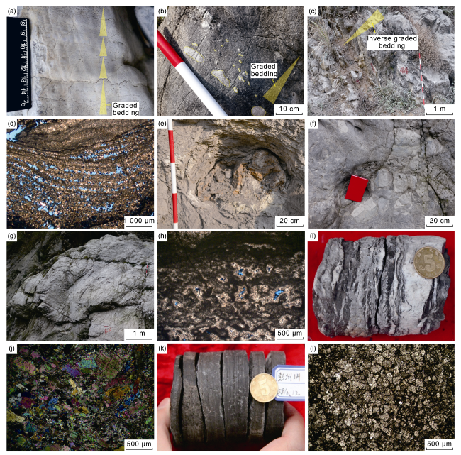
Fig. 2. Depositional facies indicators of Lei-4 Member in western Sichuan Basin. (a) Four stages of graded bedding of Lei-4-3 in Hanwang section; (b) Storm rudite layer of Lei-4-3 in Majiaoba section; (c) Inverse graded bedding of Lei-4-3 in Majiaoba section; (d) Stromatolitic dolostone of Lei-4-3 in Well YS1, 6 220.41 m, plane-polarized light; (e) Convolute bedding of Lei-4-3 in Lixiyan section; (f) Collapse breccia dolostone of Lei-4-3 in Hanwang section; (g) Microbial reef of Lei-4-3 in Hanwang section; (h) Clotty stromatolitic dolostone of Lei-4-3 in Well YS1, 6 207.59 m, plane-polarized light; (i) Thin-layered gypsum-salt rocks and dolomicrite alternation of Lei-4-2 in Well SM1, 4 167.80 m; (j) Massive anhydrite of Lei-4-2 in Well SM1, 4 154.85 m, crossed polarized light; (k) Gypsum dolomite with interbedded mudstone of Lei-4-3 in Well PZ1, 5 810.12 m; (l) Dolomitic limestone of Lei-4-1 in Dafeishui section, plane-polarized light. |
The stromatolitic structures appearing in the sections of Hanwang, Dafeishui and Majiaoba and Well YS1 (Fig. 2d ) result from such environments under relatively weak hydrodynamic conditions as the subtidal bay environment.
The convolute bedding related to the intra-layer wrinkling driven by the gravity flow usually indicates the fore-platform slope environment, which has been recognized in the Lixiyan outcrop section (Fig. 2e ).
The collapsed deposits are mostly composed of breccia in different sizes, which distribute in a skirt-like pattern within the platform marginal slope zone, and mainly identified in the Hanwang outcrop section (Fig. 2f ). There are four cycles from microbial reef buildup to collapse with petrological variation from laminated-stromatolite to breccia-rudite, which reveal the pre-reef collapse deposits of the storm-related microbial reef [5].
The nodular structure results from the differential deformation between the argillaceous and carbonate composition driven by gravity, which seldom occurs in the Leikoupo Formation but only in the Lei-4 Member of Hanwang section. However, the limestone with nodular structure is extensively spread in the Tianjingshan Formation, which could indicate the deep-water slope environment.
The turbidites are mainly presented as rhythmic alternations of banded limestone, breccia limestone and sparry oolitic limestone, which are related to the low-density turbidity currents below the storm wave base in the slope environment [17].
The reefs such as the spongy reef and microbial reef have been recognized in the Lei-4 Member. The spongy reef has been discovered in Well LS1 in a total thickness of more than 10 m without the bonding biological crusts, indicating the subtidal bay in a relatively deep water environment. The thick-layered to massive microbial reef has been mostly examined in the Hanwang section with a single reef body thickness of 2-3 m, and gradually transitions to clotty and laminated-stromatolitic dolostone upward (Fig. 2g ), part of which has been destroyed by the storms, suggesting the bay margin environment.
2.1.2. Unique lithofacies indicators
2.1.2.1. Microbialites
The thrombolites are composed of the irregular aggregated grains being bonded or cemented by the microbes without any broken and erosion signs on the edge in a size of about 0.03-3.00 mm [18] (Fig. 2h ). The long-term stable anoxic sulfurization environments are favorable for the development of thrombolites[8], suggesting subtidal flat in relatively deep water.
Stromatolites are mostly moundy or stratified in dark-light laminations in width of about 2 mm and undulation amplitude of 1.6-2.0 mm with alternations of dark microbial lamination and light silt-sized crystalline dolomite lamination (Fig. 2d ). It is thought that the stratified stromatolites result from microbial mat deposits in anoxic, weak hydrodynamic environment such as intertidal zone within a restricted tidal flat but the hummocky stromatolites have been produced in a relatively high-energy condition, such as the bay margin area[8-9].
The clotty stromatolites are mostly present in Lei-4-3 in the central part of western Sichuan Basin, which are in a transitional form of thrombolite and stromatolite with much more intermittent laminations in contrast to the typical stromatolites. The clotty stromatolites represent the irregular and uneven blotchy deposits controlled by the microbial mats mostly in a relatively high-energy zone [9,18], which located near the coastline [19].
2.1.2.2. Tempestites
The storm deposits of the Lei-4 Member in western Sichuan Basin are mostly distal tempestites, which indicate the bay slope environment below the fair-weather wave base [5-6]. Furthermore, seven types of storm depositional sequences have been recognized in those tempestites, suggesting the turbidite current depositional environments in the upper part and the lower part of bay slope, and below the storm wave base [6].
2.1.2.3. Gypsum-salt rocks
The Leikoupo Formation gypsum-salt rocks in western Sichuan Basin mostly consist of dolomitic gypsum rock, gypsum and anhydrite, locally with salt rock and polyhalite, etc. [4,14,19]. The gypsum-salt rocks of Lei-4 Member mostly locating in both Lei-4-1 and Lei-4-2, with much more percentage within the latter, are composed of grayish white thick-bedded gypsum with interbedded thin dolostone in the cores (Fig. 2i ) and laminated anhydrite in a thickness of 30-50 μm under a microscope with gypsum karst breccias in a size of larger than 1 cm in evaporated tidal flat. The evaporates along the belt from Dayi, Qionglai to Ya’an of western Sichuan Basin are in a total thickness of 80-200 m, indicating a lagoon occurring in a northeast to southwest direction [20-21].
2.2. Depositional facies types
Three depositional facies, evaporated tidal flat, restricted tidal flat and bay, have been identified in the Lei-4 Member in western Sichuan Basin (Table 1 ).
Table 1. Depositional facies of the Lei-4 Member in the western Sichuan Basin |
| Facies | Subfacies | Mircrofacies | Facies indicators | Horizon |
|---|---|---|---|---|
| Evaporated tidal flat | Evaporated lagoon | Gypsum-salt lagoon | Thick-layered gypsum-salt rocks and salt rocks | Lei-4-1 to Lei-4-2 |
| Supratidal zone | Gypsum dolomitic flat/ Dolomitic gypsum flat | Gypsum-salt rocks with interbedded dolostone or gypsum-dolostone alternation | Lei-4-1 to Lei-4-3 | |
| Restricted tidal flat | Restricted lagoon | Dolomitic lagoon | Dolomicrite | Lei-4-1 to Lei-4-2 |
| Argillaceous dolomitic lagoon | Argillaceous dolostone, dolomicrite | Lei-4-1 to Lei-4-2 | ||
| Intertidal zone | Microbial flat | Laminated clotty-stromatolitic dolostone | Lei-4-3 | |
| Dolomitic flat | Micritic-crystalline powder dolostone | Lei-4-1 to Lei-4-3 | ||
| Limy dolomitic flat | Limy dolostone | Lei-4-1 to Lei-4-3 | ||
| Subtidal zone | Limy flat | Micrite | Lei-4-1, Lei-4-3 | |
| Dolomitic limy flat | Dolomitic limestone | Lei-4-1 to Lei-4-3 | ||
| Bay | Bay margin | Grain bank | Thick-layered residual dolarenite/dolorudite/ oolitic dolostone | Lei-4-3 |
| Microbial reef | Thrombolite, stromatolite and oncolite | Lei-4-2 to Lei-4-3 | ||
| Subtidal bay | Microbial flat | Clotty dolostone, stromatolitic dolostone | Lei-4-1 to Lei-4-2 | |
| Deep-water spongy reef | Spongy micrite | Lei-4-3 | ||
| Hydrostatic mudstone | Argillaceous limestone and argillaceous dolostone | Lei-4-1 to Lei-4-3 | ||
| Bay slope | Upper slope | Collapse deposit, slope breccia, convolute bedding, tempestite | Lei-4-1 to Lei-4-3 |
2.2.1. Evaporated tidal flat
Evaporates are mostly deposited in the hypersaline seawater within the extremely hot climate [14,22]. The evaporated tidal flat facies is subdivided into the evaporated lagoon and supratidal zone according to sedimentary location, which mostly locates in Lei-4-2. The gypsum dolomitic flat and dolomitic gypsum flat have been examined in the supratidal zone but only gypsum-salt lagoon has been recognized in evaporated lagoon. The gypsum dolomite, dolomite-gypsum salt rock alternations (Fig. 2i ) and thick-layered to massive gypsum-salt rocks (Fig. 2j ) occur successively in an ascending order, which correspond to gypsum dolomitic flat, dolomitic gypsum flat and gypsum-salt lagoon. However, the three microfacies distribute in a bull-eye pattern horizontally.
2.2.2. Restricted tidal flat facies
It refers to the tidal flat environment with restricted water body obstructed by the barrier beach or peripheral uplift with lithology of dolomicrite-silt-sized crystalline dolostone, gypsum dolomite and limy dolostone [23]. The restricted tidal flat facies of Lei-4 Member in western Sichuan Basin, mostly found in Lei-4-3, has encompassed the subtidal zone, intertidal zone and restricted lagoon in subfacies. And the restricted lagoon subfacies has been subdivided into dolomitic lagoon and argillaceous dolomitic lagoon in microfacies with laminated argillaceous dolostone, thin- to extremely thin-bedded dolomicrite, and gypsum dolomite with interbedded mudstone in lithology (Fig. 2k ). The intertidal zone is divided into microbial flat, dolomitic flat and limy dolomitic flat in microfacies, while the subtidal zone is further subdivided into limy flat and dolomitic limy flat in microfacies with thin-bedded limestone, argillaceous limestone and dolomitic limestone in lithologic composition (Fig. 2l ).
2.2.3. Bay facies
The bay facies refers to a kind of special depositional facies in a relative deep-water medium extending into craton along the margin but shows little typical features of bay after the following tectonic evolution and modification in the geological history [24]. The bay facies of the Lei-4 Member in western Sichuan Basin is also a relatively deep water depositional facies in a semi-enclosed to semi-opened hydrodynamic condition from the western margin of upper Yangtze plate into the carbonate platform in a northwest direction with seaward occlusion by the Longmenshan island chain.
The depositional evidences to validate the bay facies of the Lei-4 Member in western Sichuan Basin have been listed as follows. (1) The storm deposits in multiple stages and sites, being recognized in the Hanwang section and Well LZ2 (Fig. 2b ), reflects an open environment free flowing to the ocean at that time as well as a slope in benefit for the transportation of storm debris. Besides, it is believed that the storms often land perpendicular to the coastline and thus the distribution of tempestites could indicate the trend of paleocoastline in a northeast to southwest direction in the Lei-4 Member in western Sichuan Basin [5-6]. (2) The extensively spread microbialite buildups such as the microbial flat or microbial reef consisting of stromatolite and stromatolitic-thrombolite (Fig. 2d , 2h) in continuous distribution from northeast to southwest in a northeastward thinning trend indicate an open shallow-water tidal flat environment [7⇓-9]. It has been further proven that the distribution of microbialites can also indicate the coastline of the paleo-bay [19,25]. (3) The gypsum-salt rocks, dolomitic gypsum rock and alternation of dolostone and gypsum-salt rock developed in a large quantity under the strongly evaporated climate of the regression phase during the depositional period of Lei-4-2 suggest the evaporated tidal flat environments (Fig. 2i , 2j). However, it transitioned into the microbial flat and limy dolomitic flat after the transgression event during the depositional period of Lei-4-3 [26], indicating the restricted tidal flat environment. In addition, it is discovered that the tempestites, microbialites and gypsum-salt rocks occur horizontally in an eastward alternation, with the facies spacing of 5-8 km in a narrow-zoned dramatic facies transition trend, which illustrates the rapid variations from the open, semi-restricted, restricted to evaporated environments in western Sichuan Basin. Therefore, it is speculated that the bay facies under the semi-restricted to semi-open hydrodynamic conditions in a northwest to southeast trend should exist between the paleocoastline and slope seawardly obstructed by submarine paleo-uplifts related to the Longmenshan island chain.
The bay slope subfacies mostly locates between the basin and subtidal bay at the lower part of the bay in topography, which is between wave base and storm wave base in hydrodynamics with a much deeper water medium and a larger slope gradient. And it is mostly comprised by thin layered nodular limestone, argillaceous limestone with interbedded mudstone and locally mudstone-limestone rhythmic alternation, with storm deposits, horizontal bedding, collapse deposit, nodular structure and silicification lamination in depositional structures. The bay slope subfacies has mostly been recognized along the belt from Dafeishui, Hanwang to Majiaoba, which is only composed of the upper slope in microfacies.
The subtidal bay subfacies at the upper part of the bay in topography, is mostly between the bay slope and bay margin subfacies horizontally with the hydrodynamic condition between the mean low tide line and wave base. And it is in a relatively deep water environment with a smaller slope gradient and a larger mud content, which is usually constituted by the argillaceous dolostone, argillaceous limestone and spongy micrite, and locally developed microbialites at relative higher positions along PZ115-YS1-CK1-TS1-Z46-Majiaoba-Shangsi. Therefore, the subtidal bay subfacies has been divided into microbial flat, deep-water spongy reef and hydrostatic mudstone in microfacies.
The bay margin subfacies lying above the mean low tide line in a shallower depositional environment with intermittent exposure and a gentle slope gradient, is dominated by residual grain dolomite and microbialites in lithology. And it locates between the subtidal bay and subtidal zone with grain bank and microbial reef in microfacies. It is comprised by the thrombolite, stromatolite and oncolite correspondingly originating in lower-energy, weakly-disturbed and higher-energy environments within the central part of western Sichuan Basin, which could outline the general bay boundary. The grain bank occupies the northern part in composition of residual dolarenite, dolorudite, oolitic dolostone and local residual algae clastic dolostone. Till into the southern part, it is mostly microbial reef buildups in horizontal trend of northeast to southwest.
2.3. Depositional model
We proposed a paleo-bay depositional model of the Lei-4 Member and clarified the depositional model of ocean-bay-flat in western Sichuan Basin based on the distribution characteristics of facies indicators and zones.
At the end of Middle Triassic, the sag resulting from the inward extending along the western margin of upper Yangtze plate as well as the rapidly uplifting paleohighs at Kaijiang and Luzhou led to the gradual formation of restricted bay in the western Sichuan Basin under the barrier of Longmenshan island chain and Tianjingshan paleo-uplift [26-27], with a deeper water medium, a seaward westwardly inclining slope and an eastward narrow-zoned facies transition of the restricted to evaporated tidal flat (Fig. 3 ), which is similar to the middle Eocene paleo-bay in the Tarim Basin [28].
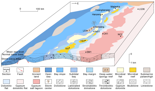
Fig. 3. Paleo-bay depositional model of Lei-4 Member in western Sichuan Basin. |
Four 4th-order sequences, that is, SSq1, SSq2, SSq3 and SSq4, in an upward trend, have been recognized in the Lei-4 Member in western Sichuan Basin based on the relationship between lithology and electricity as well as facies evolution characteristics, with all the related five sequence boundaries to be lithological transition interfaces. On the low-lying east-to-west-oriented terrain, the bay slope subfacies covered western Sichuan Basin during the depositional period of SSq1 when the sea level fell slowly from a highstand phase. The microbial flat in subtidal bay occurs at well areas of LS1 and CK1, and turns into the microfacies of gypsum dolomitic flat and dolomitic flat in supratidal zone in central Sichuan Basin.
The sea level was in an ephemeral regression stage during the depositional period of SSq2, which is shown as the microbial flat of subtidal bay in the Hanwang section, gradually changing into the subfacies of supratidal zone to evaporated lagoon, with gypsum dolomitic flat and gypsum-salt lagoon in well areas of LS1 and CK1 correspondingly.
In the depositional period of SSq3, the range of the paleo-bay spread into the well area of CK1 due to the sea level fluctuation of rapidly rising in early stage and then slowly falling. The microbial reef on bay margin developed in the falling cycle of sea level within the well area of LS1. However, it gradually turns into dolomitic flat in the restricted intertidal flat subfacies and gypsum dolomite flat or dolomitic gypsum flat in the supratidal zone within the eastward well area of FG1-NC2-LiT1.
The paleo-bay covered the largest area, and even reached the well area of LiT1 in the central Sichuan Basin, during the depositional period of SSq4 when the sea level surged constantly. The upper slope in the Hanwang outcrop section inferred by the tempestites, and deep-water spongy reef has been found out in the well area of LS1. The microbial reef on the bay margin dominates in the well area of CK1.
In general, it is in a eustatic cycle from regression to transgression and again regression during the depositional period of Lei-4 Member. The bay and restricted tidal flat facies mostly cover the western Sichuan Basin. The bay facies evolve vertically in a facies association from bay slope, subtidal bay to bay margin with the westward and again eastward migration horizontally. In the central Sichuan Basin, it is mostly occupied by the intertidal zone within restricted tidal flat, the supratidal zone and evaporated lagoon in evaporated tidal flat within well areas of NC2-LiT1 with the gypsum dolomitic flat, dolomitic gypsum flat and gypsum-salt lagoon in microfacies (Fig. 4 ).
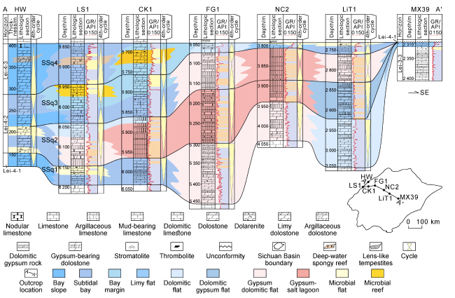
Fig. 4. Well-tie section of east-west depositional facies of Lei-4 Member in western Sichuan Basin. |
3. Characteristics of the paleo-bay in the Lei-4 Member
The contour lines of dolomite, lime, gypsum and mud contents in the three submembers of Lei-4 Member have been mapped based on the mineral composition of about 400 wells in Sichuan Basin from well log data interpretation by Ciflog software and 11 outcrop sections, in order to characterize the composition distribution in the paleo-bay in different periods.
3.1. The depositional period of Lei-4-1
It mostly ranges from 10% to 24% for the mud content in Lei-4-1 in western Sichuan Basin with an average of 16%. The lithology is composed of the argillaceous dolostone and argillaceous limestone in a thickness of 20-50 m, which mostly distribute in the central part of western Sichuan Basin, in both thinning trend toward south and north, indicating the features of subtidal bay subfacies (Fig. 5a ).
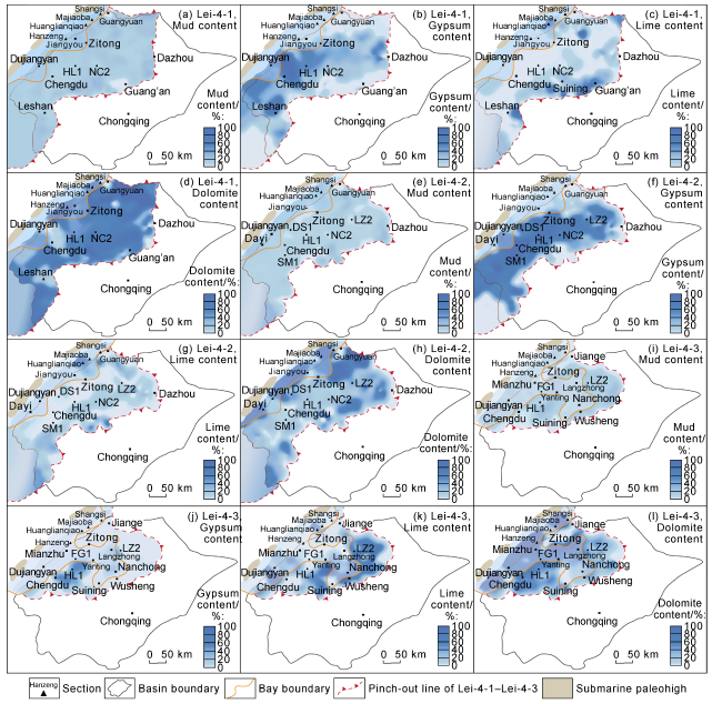
Fig. 5. Contour lines of mud, lime, gypsum and dolomite contents of Lei-4-1 to Lei-4-3 in the Sichuan Basin. |
The gypsum content of Lei-4-1 varies greatly, which mostly range from 50% to 95% in the central to southern part in a thickness of 20-30 m (Fig. 5b ), consisting of gypsum dolomite, dolomitic gypsum rock with interbedded gypsum-salt rocks in the supratidal zone of evaporated tidal flat facies. However, it dramatically decreases in the north part area in an average content of about 5% comprised by micritic-silt-sized crystalline dolostone, gypsum-containing dolostone and argillaceous dolostone with the thickness of 1-5 m, suggesting the features of intertidal zone in the restricted tidal flat.
It is mostly in the range of 2%-20% for the lime content of Lei-4-1 with an average of 7% in a thickness of 5-10 m (Fig. 5c ). It is mostly comprised by the thin-bedded micritic limestone, which only occurs in the Majiaoba outcrop section of the northern part, indicating the features of subtidal bay subfacies.
The dolomite content within Lei-4-1 is generally in a larger range of 10%-90% with an average of 70%. It is mostly comprised of the clotty-stromatolitic dolostone, stromatolitic dolostone and dolomicrite with a total thickness of 50-100 m (Fig. 5d ). The dolomite contents are of 70%-85% and 40-60 m thick within the central to northern parts, indicating the intertidal zone in the restricted tidal flat, while they are in a sharp decrease in a range of 5%-10% and with a thickness of 10-15 m into the southern part, inferring the supratidal zone in the evaporated tidal flat.
Moreover, it is found that the dolomite and gypsum contents are in relationship of falling to rising horizontally and adjacent to one another in spatial position (Fig. 5b , 5d). Thus, the center of bay during the depositional period of Lei-4-1 was located at the belt from Jiangyou to Hanzeng in an area of about 27 000 km2 with the bay margin from Guangyuan, Zitong to Dujiangyan based on the comprehensive analysis of the single factors.
3.2. The depositional period of Lei-4-2
The mud contents in Lei-4-2 in western Sichuan Basin are in the range of 10%-20% with an average of 15%, which are comprised by argillaceous limestone and argillaceous dolostone in a thickness of 15-30 m (Fig. 5e ). It reaches up to 20%-30% in the outcrop sections of Dafeishui and Majiaoba, which demonstrates the features of subtidal bay subfacies.
The gypsum content of Lei-4-2 is generally high in the western Sichuan Basin, mostly in the range of 50%-90% with an average of 75%, which mostly consists of dolomitic gypsum rock, dolomite-containing gypsum rock and gypsum-salt rocks in a total thickness of 50-80 m (Fig. 5f ). The gypsum content of well areas from DS1, SM1, HL1, NC2 to LZ2 surges to 80%-90%, which indicates the features of gypsum-salt lagoon of the evaporated lagoon subfacies.
It is mostly in a range of 1%-4% for the lime content of Lei-4-2 with an average of 2% and a total thickness of 5-10 m, which is constituted by the lime-containing dolostone, dolomite-containing limestone and argillaceous limestone (Fig. 5g ). However, it reaches up to 70%-80% in the Huanglianqiao section in the northern part, indicating the features of subtidal bay subfacies.
The dolomite content of Lei-4-2 in western Sichuan Basin is in a greater range of 10%-90% with an average of 30% (Fig. 5h ). It is mostly composed of micritic-silt-sized crystalline dolostone, mud-containing dolostone, gypsum- containing dolostone, gypsum dolomite, and clotty-stromatolitic dolostone with a total thickness of 10-50 m, which suggests the features of subfacies of intertidal zone and restricted lagoon in the restricted tidal flat and the supratidal zone within the evaporated tidal flat.
It is in a sustained regression phase during the depositional period of Lei-4-2, which results in the greatly decreasing of mud content and dramatically increasing of both the dolomite and gypsum contents in western Sichuan Basin. The depositional center of the bay was the front region of Longmenshan Mountains with an area of about 15 000 km2 and the coastline of the bay migrating toward west, the central part of the bay narrowing and bay margin along the belt zone from Shangsi, Jiangyou to Dujiangyan.
3.3. The depositional period of Lei-4-3
The mud content constituted by the argillaceous dolostone, argillaceous limestone and calcareous mudstone in Lei-4-3 in western Sichuan Basin is 20%-30% with an average of 23% and a thickness of 20-30 m (Fig. 5i ). The coverage of argillaceous rocks spread eastward into the Nanchong to Suining area, which referring to expansion of the subtidal bay subfacies under the transgression conditions.
The gypsum contents of Lei-4-3 are mostly of 1%-3% with an average of 2% and in a thickness of 3-15 m, which is comprised by the gypsum-containing dolostone and gypsum dolomite (Fig. 5j ). The gypsum-salt rocks in a small amount have only been found out in the areas of Chengdu and Well HL1, suggesting the features of supratidal zone.
The lime content of Lei-4-3 ranges from 5% to 60% with an average of 15% and a thickness of 10-15 m, which is dominated by the micrite, argillaceous limestone, limy dolostone and dolomitic limestone in lithology (Fig. 5k ). In the central to southern part, it rises to 40%-50% along the area from Langzhong to Nanchong, which reflects the features of subtidal zone.
It is mostly in the range of 60%-80% for the dolomite contents of Lei-4-3 with an average of 71% and in a total thickness of 50-60 m, which consists of clotty-stromatolitic dolostone, stromatolitic dolostone, and micritic- silt-sized crystalline dolostone (Fig. 5l ). The dolostone has been widespread in the western Sichuan Basin in an eastwardly decreasing trend, which is directly related to the microbial flat in the intertidal flat and the grain bank to microbial reef within the bay margin subfacies.
The coverage of the bay got further enlarged resulting from the small-scaled transgression during the depositional period of Lei-4-3, with the bay margin eastward into the Nanchong-Suining area. It is in an increasing trend for mud, lime and dolomite contents while otherwise for the gypsum content, inferring the deepening and opening hydrodynamic conditions during the transgression progress. The depositional center of bay lies in the belt of Dujiangyan-Mianzhu-Nanchong in the central part with an area of about 35 000 km2 and the coastline of the bay along Shangsi, Zitong, Langzhong, Wusheng, Yanting to Chengdu.
4. Depositional evolution process of the bay during the depositional period of Lei-4 Member
The depositional model of ocean-bay-flat in a northwest to southeast direction appeared during the period of Lei-4-1, with the bay center in Jiangyou to Hanzeng area and the bay boundary lying in the belt of Guangyuan- Zitong-Dujiangyan. It is mostly covered by the microbial flat in subtidal bay in central to northern parts while the restricted to evaporated tidal flat facies dominate the eastern part with the eastward microfacies association from dolomitic flat, gypsum dolomitic flat, gypsum-salt lagoon, gypsum dolomitic flat, dolomitic flat to limy flat. These microfacies generally symmetrically distribute surrounding the three elliptically to irregularly shaped gypsum-salt lagoons in central to southern parts. The gypsum dolomitic flat occurs in strip-shape area from Langzhong, Yanting to Ya’an while the dolomitic flat is in a ring-shape along Jiange, Dazhou, Nanchong to Leshan, with the limy flat dominates in Guang’an to Ziyang (Fig. 6a ).

Fig. 6. “Ocean-bay-flat” depositional model in Lei-4-1 to Lei-4-3 in western Sichuan Basin. |
It kept the depositional model of ocean-bay-flat during the period of Lei-4-2, with westward migration for all the coverage, center and margin of the bay owing to the continuously sea-level falling. The bay center migrates to the front region of Longmenshan Mountains with the bay boundary westward migrating to the belt area from Shangsi, Jiangyou to Dujiangyan and mostly being occupied by the microbial reef in a northeast trend. The hydrostatic mudstone of the subtidal bay mostly dominate the interior of the bay, which eastwardly transitions into the intertidal to supratidal zones within the restricted to evaporated tidal flat. The microfacies association of dolomitic flat, gypsum dolomitic flat and gypsum-salt lagoon distribute symmetrically in a ring shape. However, it is in a much smaller coverage for the dolomitic flat, gypsum dolomitic flat than that of Lei-4-1 but otherwise for the gypsum-salt lagoon along the area in a northeast to southwest trend from Yanting, Chengdu to Ya’an with the lagoon deposition center moving to the Renshou-Danleng in the southern part (Fig. 6b ).
The depositional model of ocean-bay-flat still sustained during the period of Lei-4-3 when the sea-level was rising. The bay began to expand eastwardly into the Pengzhou-Qionglai area in the south part, to the area of Mianzhu-Yanting-Nanchong-Suining in the central part and Shangsi-Langzhong area in the north part. The bay boundary migrated along the belt area from Shangsi, Zitong, Langzhong, Wusheng, Yanting to Chengdu overall in the shape of horn. Therefore, the bay facies is gradually together with the restricted to evaporated tidal flat facies horizontally in a short distance. Besides, the upper slope indicated by the collapsed microbial reef blocks and tempestites have been recognized in the Hanwang outcrop section in the bay slope while the deep-water spongy reef dominates the well area of LS1 located at the subtidal bay. The microbial reef at the bay margin has been found out in a northeast strip-shaped area from Dayi, Pengzhou to Well CK1. The grain bank lying in the northeast part of the bay margin distributes along the area from Jiange to Longgang. It is in a symmetrical occurrence from north to south with the paleo-bay as the center for both dolomitic flat and limy flat in the restricted tidal flat. But the gypsum dolomitic flat in the evaporated tidal flat only locates in the area from Longquanyi to Huilong (Fig. 6c ).
5. Hydrocarbon geological significance
5.1. The paleo-bay controls the occurrence of high-quality source rocks
The paleo-geomorphic pattern of “one high and two lows” in the Lei-4 Member in western Sichuan Basin is reflected by the depositional model of ocean-bay-flat. The facies association is present from basin, bay slope, subtidal bay (low), bay margin (high), restricted tidal flat and gypsum-salt lagoon in evaporated tidal flat (low) in an eastward trend. Bordered by the bay margin, two different types of source rocks have been developed in both eastern and western sides.
The extremely thin-bedded organic matter-rich mudstone and lime-containing mudstone in the deep-water reducing environment on the western side of paleo-bay distribute along the bay slope in a northeast trend. It is 100-150 m in thickness, 0.02%-0.81% in TOC with an average of 0.37% and about 2.0% in Ro. The organic matter type is humic-typed kerogen in a high mature to overmature stage [29-30].
The mudstone and evaporates deposit in the evaporated lagoon on the eastern side of paleo-bay, in which the organic matter is enriched due to the cyanobacteria flourish. The source rocks of Lei-4-2 occur in the gypsum-salt lagoon in a northeast direction. It is 10-100 m thick, 0.02%-1.72% in TOC and larger than 2.0% in Ro, which is mostly composed of Type I kerogen in an overmature stage with the vitrinite as the main kerogen maceral with a lower TOC but a higher conversion rate [29].
5.2. Large-scaled reservoirs develop along the paleo-bay margin
The extensively widespread microbialite reservoirs in a total thickness of 30-160 m develop in the Lei-4 Member in western Sichuan Basin, mainly consisting of clotty- stromatolitic dolostone and stromatolitic dolostone and secondarily thrombolitic dolostone, with porosity of 0.07%-23.7% and an average of 3.70%, permeability of (0.007 3-1 050)×10−3 μm2 and an average of 9.31×10⁻³ μm2. The reservoir spaces are mostly microbial framework pore, fenestral pore, intragranular dissolved pore and dissolved fracture. The paleo-geomorphic pattern of “one high and two lows” related to the paleo-bay in the Lei-4 Member exert significant influences on the distribution of high-quality reservoirs. The reservoirs of microbial reef and grain bank microfacies in northwest and northeast trend develop along the bay margin. Moreover, the reservoir quality has been further improved by the modification of the penecontemporaneous karstification resulting from the high frequency sea level falling and the penecontemporaneous dolomitization process [7-8,11].
5.3. Hydrocarbon geological significances of paleo-bay in the Lei-4 Member in western Sichuan Basin
It is of great hydrocarbon geological significance for the discovery and description of the paleo-bay in the Lei-4 Member in western Sichuan Basin. On one hand, it explains the narrow-zoned facies transition in a short distance from open to restricted environment and also clarifies the response characteristics during the ocean-continent transition process in Middle Triassic. On the other hand, it provides two new types of source and reservoir configuration models of self-generating and self-storing, side-source and side-reservoir.
The currently discovered gas pools in the Lei-4 Member in western Sichuan Basin are mostly structural reservoirs and structural-lithologic composite reservoirs [29-30], in configuration type of upper source and lower reservoir or upper reservoir and lower source with the underlying Upper Permian Longtan Formation or overlying Upper Triassic Xujiahe Formation being the source rock and microbialites in Lei-4 Member as the reservoirs [7-8]. Thus, the new source-reservoir assemblage types of self-generating and self-storing and side-source and side-reservoir have been produced by the source-reservoir relationship of horizontal interaction and vertical superimposition in the paleo-geomorphic pattern of “one high and two lows” controlled by the paleo-bay in the Lei-4 Member. The configuration type of self-generating and self-storing has been present when the hydrocarbons originated from mudstone and evaporates in the gypsum-salt lagoon directly migrate into the nearby limestone and dolostone reservoirs. The type of side-source and side-reservoir has appeared in the paleo-bay margin area with a large-scale microbial reef and grain bank reservoir horizontally contacting in large area with the source rocks within the sags on both sides of the paleo-bay (Fig. 7 ). This configuration type has great hydro-carbon generation potential and the superiority of near- source accumulation, which can significantly improve the oil-gas accumulation efficiency. And the two source-reservoir assemblage types would create a new situation for hydrocarbon exploration of Leikoupo Formation.
Fig. 7. Distribution of paleo-bay of Lei-4 Member in western Sichuan Basin and the model of source-reservoir assemblage under its control. |
6. Conclusions
The depositional model of ocean-bay-flat is proposed for the Lei-4 Member in western Sichuan Basin. Three types of depositional facies, i.e. bay, restricted tidal flat and evaporated tidal flat, are recognized with bay slope, subtidal bay and bay margin subfacies in the bay facies.
The bay center lay at the area from Jiangyou to Hanzeng in the central part of western Sichuan Basin during the period of Lei-4-1 with coastline along the area of Guangyuan-Zitong-Dujiangyan. During the period of Lei-4-2, the bay center moved to the front region of Longmenshan Mountains in the central part of western Sichuan Basin with coastline sustainedly migrating toward west in the belt area from Shangsi, Jiangyou to Dujiangyan. During the period of Lei-4-3, the bay center expanded eastwardly to the area of Dujiangyan, Mianzhu to Nanchong with the boundary in a horn shape along the Shangsi, Zitong, Langzhong, Wusheng, Yanting to Chengdu area.
The depositional model of ocean-bay-flat in northwest to southeast direction appeared during the period of Lei-4-1 with the microbial flat in subtidal bay occurring in the central to northern parts. It kept the depositional model of ocean-bay-flat during the period of Lei-4-2, with the hydrostatic mudstone microfacies in the subtidal bay and microbial reef on bay margin. But it eastwardly transitioned into the intertidal to supratidal zones in the restricted to evaporated tidal flat with the microfacies association of dolomitic flat, gypsum dolomitic flat and gypsum-salt lagoon distributing symmetrically in a ring pattern. In the period of Lei-4-3, the depositional model of ocean-bay- flat in a northwest-southeast trend began to expand eastwardly in a sea level rising process with the grain bank in the northeast part and microbial reef lying in central to southern parts of the bay margin.
The paleo-geomorphic pattern of “one high and two lows” appeared in the Lei-4 Member in western Sichuan Basin reflected by the depositional model of ocean-bay- flat. Two types of high-quality source rocks are developed in the sags on both the eastern and western sides of the paleo-bay, with large-scale high-quality reservoirs develop along the paleo-bay margin. Therefore, it provides two new source-reservoir assemblages of self-generating and self-storing and side-source and side-reservoir, which would create a new situation for hydrocarbon exploration of Leikoupo Formation.