

Introduction
The Sichuan Basin is an important petroliferous basin and natural gas production base in China. More than 20 sets of oil and gas pay zones have been discovered in the Sichuan Basin[1⇓-3]. According to the recent resource evaluation, it has conventional natural gas resources of about 16.5×10¹² m3. By the end of 2020, the proven gas in place in Sichuan Basin was about 6×10¹² m3, and the natural gas production in 2020 exceeded 500×108 m3. The Sinian-Cambrian system is a set of major natural gas pay zones distributed across the whole basin. After the finding of the Weiyuan gas field, whose pay zone is the Dengying Formation of Sinian, in 1964, exploration and research work has continued, especially a high yield was obtained in the Sinian System in Well Gaoshi-1 drilled in the core of Gaoshiti-Moxi paleo-uplift in the central Sichuan region in 2011, when the Anyue giant gas field was found[3⇓-5]. By the end of 2020, the proven gas in place in the Anyue gas field exceeded 1×10¹² m3, with an annual natural gas production capacity of about 170×108 m3, and important exploration and development achievements have been achieved. Simultaneously, significant progress has been made in the study of the Sinian-Cambrian structural evolution, deposition, reservoir and reservoir forming in the whole basin [6⇓⇓⇓-10]. The understandings that there existed the Gaoshiti-Moxi paleo-uplift and Deyang-Anyue intracratonic rift, which controlled the formation and distribution of the Anyue gas field [11⇓⇓-14], and the ancient oil reservoir at the core of the inherited paleo-uplift cracked in-situ to form the present gas reservoir have been proposed [14⇓-16], guiding the exploration of the paleo-uplift effectively. The proposal of Deyang-Anyue intracratonic rift is an important progress in the study of the Sinian-Cambrian system in Sichuan Basin [3,13 -14]. Although there are controversies on the nature of intracratonic rift [13-14], extensional trough [11], extensional erosion trough [17], etc., there is a consensus that there were structural differences in the sedimentary period of Dengying Formation in Sichuan Basin, and the rifts controlled the deposition, reservoirs and accumulation in and around this area [6,18 -19]. After the discovery of the Anyue giant gas field, explorationists and researchers are searching for the second "Anyue giant gas field". On one hand, the Gaoshiti-Moxi area where the Anyue giant gas field is has been at a structural high part from ancient days to now, but the other areas in the large central Sichuan region are on the background of the slope of the paleo-uplift on the whole, with few local structural traps developed, so it is difficult to find large-scale exploration targets under the guidance of the existent theoretical understandings. On the other hand, it is generally believed that once a major exploration discovery is made in an area and a major gas field is discovered, it is difficult to find large-scale accumulations in the periphery of the same stratum anymore, and exploration may be turned to new areas to seek new discoveries. But with superior natural gas geological conditions, the Sinian-Cambrian system in Sichuan Basin[7⇓⇓-10] has different reservoir forming models and different key exploration factors in different regions due to different accumulation conditions [3,15]. With the deepening of exploration and the increase of data [2,20⇓⇓ -23], new understandings have been gained on the evolution of the Deyang-Anyue rift and its control on the Sinian-Cambrian deposition. On this basis, Well Pengtan-1 and Well Jiaotan-1 were deployed, which made major breakthroughs in the second member of Dengying Formation (Deng2 Member for short) and the Cambrian Canglangpu Formation, respectively. Well Pengtan-1 was proposed in 2014 and deployed in 2018. It was completed at 6367 m and tested gas in 2020. The Deng2 Member revealed by this well is 635 m thick and composed of arenaceous dolomite, grape-lace dolomite and muddy to micritic dolomite. Log interpretation showed that the Deng2 Member had 275 m thick reservoir, including a gas layer of 107.6 m thick, poor gas layer of 11.6 m thick, gas-water layer of 50 m thick, and water layer of 105.8 m thick (with a porosity of more than 2%). The Deng2 Member was tested a high yield gas flow of over 100×104 m3/d. The Deng2 Member in Well Zhongjiang-2 has the same reservoir forming conditions as but top 800 m lower than that in Well Pengtan-1. Log interpretation showed that the Deng2 Member in this well had 100.6 m thick reservoir, 33.6 m thick gas layer and 15.1 m thick poor gas layer. The well was tested a gas flow of 3.6×10⁴ m3/d in Deng2 Member, indicating that large stratigraphic lithologic gas pool can be formed in the mound and shoal reservoir of Deng2 Member and the horst-controlled mound and shoal reservoir of Deng2 Member in the rift has huge exploration potential. Well Jiaotan-1 was proposed in 2016 and deployed in 2018. The well was completed in 2019 and made a breakthrough in Canglangpu Formation in 2020. The fourth member of Dengying Formation (Deng4 Member for short) revealed in Well Jiaotan-1 is 348 m (not penetrated). Based on log interpretation, the Deng4 Member had 177.6 m thick high-quality mound and shoal reservoir (with a porosity range of 2.0%-7.7%, and an average porosity of 3.3%). The gas layer of 100.3 m thick has good physical properties and rich dissolution pores and caves, with reservoir type of mainly vuggy type. Moreover, from log interpretation, the gas-water contact of Deng4 Member in Well Jiaotan-1 is -7230 m, which is nearly 2000 m lower than that of the gas reservoir of Deng4 Member in the Moxi area [16], indicating that it is relatively independent for gas reservoirs of this area and Deng4 Member in the Moxi area, and the platform margin mound-shoal of the Dengying Formation in the north slope of paleo-uplift in the central Sichuan region can form large-scale reservoirs. Based on log interpretation, the Canglangpu Formation in this well had 2 gas layers of 14.5 m thick cumulatively and 4.1% in average porosity. This formation was tested a gas flow of more than 50×104 m3/d. All these show that large lithologic gas pools in the north slope have the characteristic of multiple target layers. Based on the exploration practice and new geological understandings and analysis of new exploration wells and data, the formation mechanisms and models of large lithologic gas pools in and around the intracratonic rift have been figured out, and favorable exploration zones of different types of lithologic gas pools have been sorted out to guide exploration practice in this study. This study is of great theoretical and practical significance for deepening the understanding on the geology of gas reservoir forming conditions of the Sinian-Cambrian system in Sichuan Basin, enriching the reservoir forming theory of large deep ancient carbonate gas fields, and guiding the exploration of large gas fields in the new frontiers.
1. Rift evolution and its control over the development of large-scale reservoirs
The Sinian System is the first set of stable sedimentary cover developed above the rift basin of the Nanhua System. In unconformable contact with the gray-green tillite of Nantuo Formation, the Doushantuo Formation mainly consists of terrestrial shore-tidal flat and lagoon facies sediments, and has no carbonate platform formed in real sense yet [2,22]. In the sedimentary period of the Dengying Formation, Deyang-Anyue and Wanyuan-Dazhou intracratonic rifts[24] were formed in the Upper Yangtze platform under the action of the regional tensile force [3,16]. A lot of researches on the evolution of the Deyang-Anyue rift and its influence on deposition, reservoir and accumulation have been conducted [3,13 -14]. With the increase of data and deepening of research and the basis of previous knowledge[13], we have come to the understanding that the Deyang-Anyue intracratonic rift was developed in the depositional period from the Sinian Dengying Formation to the Cambrian Longwangmiao Formation. Seismic and petrological characteristics and other indicators related to the development of the rift have been analyzed extensively before [3,13 -14]. Through this study, the evolution of the rift can be divided into four stages, namely, the formation stage (first member of Dengying Formation (Deng1 Member) + Deng2 Member depositional period), the development stage (third member of Dengying Formation (Deng3 Member) + Deng4 Member depositional period), the filling stage (Cambrian Maidiping Formation + Qiongzhusi Formation depositional period) and the extinction stage (Cambrian Canglangpu Formation + Longwangmiao Formation depositional period) (Fig. 1 ).
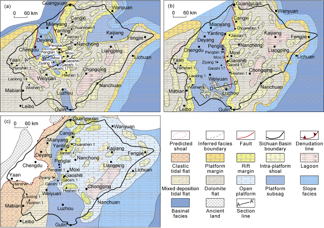
Fig. 1. Lithofacies paleogeographic maps of Deng2 Member (a) and Deng4 Member (b) and the lower member of Cambrian Canglangpu Formation (c) in Sichuan Basin. |
1.1. Rift formation stage (Deng1 Member + Deng2 Member depositional period)
In the depositional period of Deng1 + Deng2 members, the rift began to take shape. The extension resulted in the development of multiple normal faults in the platform, multi-row horst-graben structure and rugged ancient landform and multiple high terrain zones controlled by horsts (Figs. 1a, 2a and 3). Under the effect of extension, the relative sea level rose, and different sediments deposited in the high terrain zone and low terrain zone. The Deng1 and Deng2 members deposited in the ancient high terrain zones are thicker, for example, they are 550, 523 and 640 m thick in Well Gaoshi-1, Well Wei-28, and Well Pengtan-1, respectively, and are thick mound-shoal carbonate rocks mainly (Figs. 4 and 5 a-5c). The Deng1 and Deng2 members are thinner in ancient low terrain zones, for example, they are 65 and 170 m thick in Well Ziyang-1 and Well Gaoshi17, and are largely composed of nodular argillaceous micritic dolomite or argillaceous dolomite (Figs. 4 and 5 a-5b). This suggests that during the depositional period of Deng1 and Deng2 members, the areas relatively high in terrain in the rift were shallow in water and had largely thick carbonate rocks depositing, while the areas relatively low in terrain had deep water and undercompensated carbonate rocks with high mud contents depositing (Figs. 2-4).
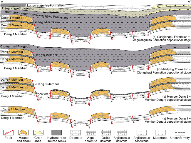
Fig. 2. Evolution model of Deyang-Anyue intracratonic rift (See |
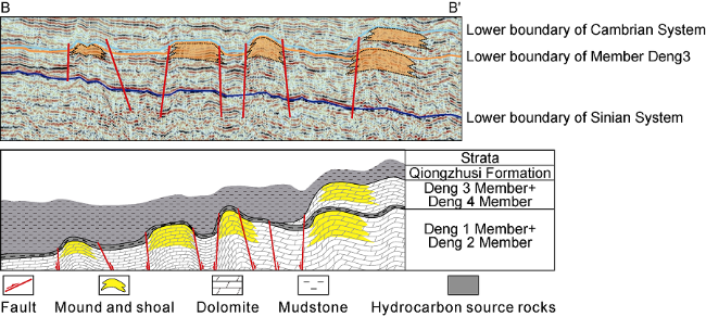
Fig. 3. Horst and graben development and seismic interpretation of horst-controlled mound and shoal complex in Deng2 Member (See |
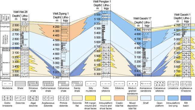
Fig. 4. Comparison of sedimentary facies between Dengying Formation and Cambrian Longwangmiao Formation (See |
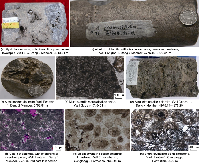
Fig. 5. Photos of typical rocks and reservoir spaces of Sinian Dengying Formation in and around the rift. |
In the formation stage, the rift had a great influence on the deposition of Deng2 Member. In the early stage, it was considered that the whole rift had undercompensated deposits, dominated by slope and shelf facies argillaceous dolomite[13-14]. In this study, the mound and shoal deposited on the horst-controlled ancient landform in the rift is called “horst-controlled mound and shoal". For example, in Well Pengtan-1 located in the rift, Deng1 and Deng2 members are 640 m thick and mainly composed of algal dolomite, arenaceous dolomite, muddy micrite dolomite and sandy dolomite of mound and shoal complex, sand debris shoal, interbank sea and dolomite flat subfacies (Figs. 5b, 5c and 6a), similar in lithology to Well Gaoshi-1 and Well Wei-28 located at the margin on both sides of the rift (Fig. 4 ). From the cores taken from Well Pengtan-1, for example, the section 5739.55-5770.00 m is mainly composed of algal stromatolite dolomite, algal lattice dolomite, arenaceous dolomite and muddy micrite dolomite. The muddy micrite dolomite is tight, while the algal dolomite and arenaceous dolomite have dissolution pores and cavities, with dolomite, quartz, asphalt etc. fillings inside, very similar to Deng2 Member in Well Gaoshi-1, Well Zi-5, Well Zi-28, etc. (Figs. 4 and 5 a-5c).
Based on the new geological knowledge and data, a new lithofacies paleogeographic map of Deng2 Member was compiled (Fig. 1 a). In the depositional period of Deng2 Member, the Upper Yangtze platform was surrounded by platform margin mound and shoal deposited at the passive continental margin, which was larger in scale than the platform margin mound and shoal developed in the intracratonic rift margin, for example, the Hujia Nanba section of Ningqiang [23]. This platform margin developed open sea slope and basinal facies sediments successively outwards, and carbonate platform facies sediments inwards. In the platform, the Deyang-Anyue and Wanyuan-Dazhou intracratonic rifts were developed, and the platform margin mound and shoal belts developed at the rift margin [15,24]. In the Deyang-Anyue rift, rows of horst-controlled mound and shoal strips trending NW developed in Deng2 Member. For example, Well Pengtan-1 and Well Zhongjiang-2 are located in larger mound and shoal strips of Deng2 Member, and the Deng2 Member has characteristics similar to that in typical wells in the platform margin of Gaoshiti and Moxi areas (Fig. 6 a) [16]. There are also intra-platform mound and shoal complex, tidal flat and lagoon subfacies developing in the platform. The lagoon deposits largely occur in southern and eastern Sichuan. Understandings on lithofacies paleogeographic characteristics of Deng2 Member in the rift have significantly deepened compared to the early days [3,24].
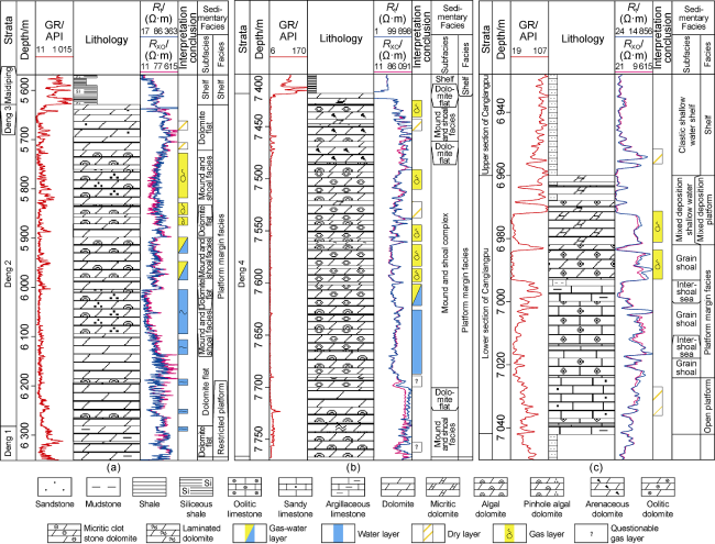
Fig. 6. Composite columnar sections of Deng2 Member in Well Pengtan-1 (a) and Deng4 Member (b) and Canglangpu Formation (c) in Well Jiaotan-1. GR—natural gamma; Rt—resistivity; RXO—flushed zone resistivity. |
1.2. Rift development stage (depositional period of Deng3 and Deng4 members)
After the deposition of Deng1 and Deng2 members, the first episode of Tongwan movement occurred, the platform was lifted on the whole, the sea level fell, and weathering crust karstification took place in Deng2 Member, resulting in a large number of dissolution pores and caves in the top of Deng2 Member, and forming parallel unconformity with Deng3 Member. In the sedimentary period of Deng3 and Deng4 members, the platform extension became stronger, and the rift extended further. The deposits of horst-controlled mound and shoal belts formed in the depositional period of Deng2 Member in the rift sank on the whole, and the main faults acting as the rift boundary became more obvious, leading to significant differences in ancient landform between the rift margin and inside rift. The Deng3 Member deposit during the overall subsidence process is composed of tuffaceous blue gray mudstone or dark mud shale with argillaceous dolomite interbeds, and is thinner both inside and outside the rift (0.4 to 60.0 m thick), for example, it is about 35 m thick in Well Gaoke-1. In the depositional period of Deng4 Member, the sea water circulation in the rift was smooth due to strong extension, and the water in the northern part of the rift was deeper, argillaceous dolomite and dolomitic mudstone with smaller thickness and higher mud content developed in the undercompensated environment. For example, the Deng3 and Deng4 members in Well Gaoshi-17 and Well Pengtan-1 are about 17 m and 13.5 m thick combined respectively. Two large platform margin mound and shoal belts up to 150 km apart developed on the east and west sides of the rift, this is basically consistent with the early understanding [3,24]. For example, the Deng3 and Deng4 members in Gaoshiti- Moxi area on the east side of the rift are 200-300 m thick mound and shoal facies at the platform margin (Figs. 1b, 4, 5d, 5e). In the southern part of the rift with shallower water, largely micrite dolomite is deposited. After the deposition of the Deng2 Member, the paleogeomorphology before the deposition of Deng3 Member was uneven due to the effect of the first episode of Tongwan Movement [25] (Fig. 7 ) and algal dolomite and mound and shoal complex might develop in local areas. After the deposition of Deng4 Member, the top surface of Deng4 Member was denuded and uneven due to the influence of the second episode of Tongwan Movement [25]. Based on seismic data, it is speculated that several isolated mound and shoal bodies of Deng4 Member developed in the southern part of the rift (Fig. 1 b), which are in unconformable contact with the mud shale of the overlying Cambrian Maidiping Formation (Fig. 7 ).
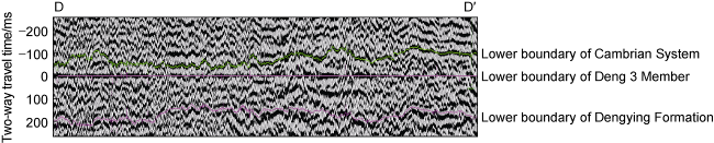
Fig. 7. Seismic profile through isolated mound and shoal complexes of Deng4 Member in the rift (See |
1.3. Filling stage (depositional period of Maidiping Formation + Qiongzhusi Formation)
In the end stage of the Sinian, the platform extension weakened, the rift expansion ended, and then the second episode of Tongwan Movement took place. Consequently, the sea level fell, and the overall platform was uplifted and exposed to denudation. At the beginning of Cambrian, the sea level rose rapidly and the rift was largely filled with sediments. Firstly, Maidiping Formation, mainly thick mud shale, deposited in and around the rift, which is thicker in the ancient low terrain zones of the rift, while that is thinner or absent on the platform. After the deposition of Maidiping Formation, the third episode of Tongwan Movement occurred. As a result, the overall platform was uplifted and subjected to denudation, forming the parallel unconformity between Maidiping Formation and Qiongzhusi Formation. After that, the overall platform subsided and the sea level rose, and thick Qiongzhusi Formation mud shale deposited across the basin. In the rift, the Maidiping and Qiongzhusi formations are hugely thick (Figs. 2 and 3 ). For example, they are 683 m thick in Well Gaoshi-17. In comparison, the Maidiping and Qiongzhusi formations at the platform margin and in the platform around the rift are thinner. For example, they are about 120 m thick in Well Gaoshi-1 (Fig. 4 ), and Maidiping Formation is missing in most parts of Sichuan Basin.
1.4. Rift extinction stage (depositional period of Canglangpu Formation + Longwangmiao Formation)
After the deposition of Maidiping Formation and Qiongzhusi Formation, the rift was basically filled up, the height difference inside and outside of the rift became smaller, and the rift entered the period of shrinkage and extinction, turning smaller in range and shallower in depth. In the depositional period of Canglangpu Formation, the paleogeomorphology still existed in the rift and affected the deposition. Canglangpu Formation is thicker in the rift, for example, it is in 203, 240 and 203 m thick in Well Gaoshi-17, Well Ziyang-1 and Well Pengtan-1, respectively. In contrast, it is thinner outside the rift and 150-170 m thick in Gaoshiti-Moxi region (Fig. 4 ). Due to the fall of sea level, the influence range of the terrigenous detrital materials from Songpan paleo-continent expanded. Hence, in the early depositional period of Canglangpu Formation, the west side of the rift had largely terrigenous detrital sediments, while the east side of the rift had mainly carbonate platform sediments and a large area of platform margin grain shoal at the margin (Fig. 5 g, 5h, 6c). In the late sedimentary period of Canglangpu Formation, the sea level fell further, and the influence of the terrigenous clastic sediments extended to the whole basin, resulting in the deposition of clastic rocks represented by sandstone and mudstone. In the sedimentary period of Longwangmiao Formation, the rift further shrank in influence range and only was lower at the center, so the stratum is thick. The rift in this period was already withered.
Few studies on the lithofacies paleogeography of the lower member of Canglangpu Formation in Sichuan Basin were carried out before, and the Canglangpu Formation was generally studied as a whole and deemed as mixed platform deposits dominated by sandstone and mudstone [26]. The study on lithofacies paleogeography of the lower member of Canglangpu Formation based on the latest drilling, outcrop, and seismic data shows that the residual lower member of Canglangpu Formation is 0-200 m thick, thicker inside the rift (more than 150 m thick in Mianyang to Jiange area), and much thinner on the platform outside the rift (generally less than 100 m thick). The lower member of Canglangpu Formation in Well Jiaotan-1 located in the eastern margin of the rift is about 82 m thick and mainly composed of thick oolitic limestone, oolitic dolomite, powder to fine-crystalline dolomite and sandy limestone (Fig. 5 c). With the Deyang-Anyue rift as the boundary, the sedimentary systems on both sides vary greatly. The sediments on the west side of the rift are mainly mixed platform sediments of clastic tidal flat and mixed tidal flat facies. The sediments on the east side of the rift are mainly clear water carbonate rocks of mainly platform margin grain shoal, open platform, lagoon and intra-platform shoal facies. The platform margin grain shoal is mainly comprised of bright crystalline oolitic dolomite, bright crystalline oolitic limestone and crystalline dolomite, and was estimated at a distribution area of about 2×10⁴ km2 on the east side of the rift. Intra-platform shoals of mainly limestone developed in the platform (Fig. 1 c).
2. Formation of large lithologic traps
2.1. Reservoirs
A lot of research on the reservoir characteristics of Sinian-Cambrian system in Sichuan Basin has been made in the early stage, and it has been confirmed that there are four sets of large-scale reservoirs in the periphery of the rift, namely, the platform margin mound and shoal complex of Deng2 Member, the platform margin mound and shoal complex of Deng4 Member, the intra-platform grain shoal of Longwangmiao Formation, and the intra-platform grain shoal of Xixiangchi Formation [3,8,23]. Three sets of large-scale reservoirs have been found recently, namely, the large-scale horst-controlled mound and shoal reservoir in the rift, the large-scale karst reservoir of Deng4 Member in the rift, and the large-scale grain shoal reservoir of Canglangpu Formation at the rift margin. Mounds and shoals or grain shoals control the development of reservoir, and are distributed widely in the north slope area, providing effective reservoir space for the formation of large lithologic gas fields.
In the northern part of the rift, the large-scale Deng2 Member reservoirs of horst-controlled mounds and shoals have the characteristics similar to the mound and shoal reservoirs at the rift margin. The horst-controlled mounds and shoals in multiple rows are relatively independent and large in scale. The mound and shoal reservoirs of Deng2 Member in the rift are good in quality, for example, the reservoirs of Deng2 Member in Well Pengtan-1 are mainly foam lamellar dolomite, algal clot dolomite, algal arenaceous dolomite, with dissolution cavities, pores and fractures as main storage space, and in low porosity and low permeability with an average porosity of 3.6% and an average permeability of 3.6 × 10⁻³ μm2. Log interpretation showed that this member had 22 reservoir sections and reservoirs more than 2.0% in porosity were about 260 m thick cumulatively (Fig. 5 a). This member has high porosity and high permeability sections locally, among them, pinhole algal arenaceous dolomite is the best. For example, the 5726.80-5851.90 m section has a higher average porosity of about 4.3% according to logging interpretation. This kind of mound and shoal reservoirs is relatively independent. According to seismic prediction, the mounds and shoals in Well Pengtan-1 area are about 1000 km2, and the other smaller mounds and shoals are 2000-3000 km2 (Figs. 1a and 8).
In the southern part of the rift, there are several isolated large-scale karst mound and shoal reservoirs in Deng4 Member. In the sedimentary period of Deng4 Member, the northern part of the rift was undercompensated, so the sediment deposited there is thin and high in mud content, and unable to become reservoir basically. In the southern part of the rift with water body shallower than the northern part, thicker carbonate rocks deposited, and sediments in low terrain zones had higher mud content and mounds and shoals deposited in the relative high terrain zones. After the deposition of Deng4 Member, the second episode of Tongwan Movement took place [27], the sea level dropped significantly, as a result, the top of Deng4 Member was exposed, and weathering crust karstification took place, giving rise to large pieces of relatively independent karst mound and shoal reservoirs. According to seismic prediction, there are eight relatively independent mound and shoal complexes in the southern part of the rift, which may be good and large reservoirs (Fig. 8 ).
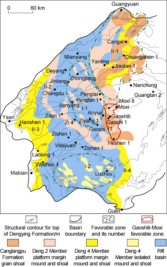
Fig. 8. Large-scale reservoirs and favorable zones for lithologic gas pool exploration in and around Deyang- Anyue rift. |
A new large-scale grain shoal reservoir of Canglangpu Formation was discovered on the eastern margin of the rift recently (Figs. 1c and 8). The reservoir is mainly composed of residual oolitic dolomite, arenaceous dolomite and powder crystalline dolomite, and has mainly intragranular dissolution pores, intergranular dissolution pores, intercrystalline dissolution pores and intercrystalline pores as reservoir space. The grain shoal reservoir encountered by Well Jiaotan-1 is about 26 m thick, 3.8%-8.1% and 4.1% on average in porosity, and 0.053× 10⁻³ μm2 in average permeability. According to statistics of logging interpretation data of wells at the rift margin, this set of grain shoal reservoir is generally 5-26 m thick (Fig. 4 c), and 2%-5% in porosity, representing low porosity and low permeability carbonate reservoir.
Platform margin mounds and shoals of Deng2 Member and Deng4 Member appear in large pieces in the north slope of the rift margin (Fig. 8 ). With large thickness and good reservoir quality, they are similar with the platform margin mound and shoal reservoirs of Deng2 Member and Deng4 Member in the Gaoshiti and Moxi regions [3]. For example, Deng4 Member revealed in Well Jiaotan-1 is about 350 m thick, in which mound and shoal complex is about 280 m thick, and consists of two thick algal mounds and grain shoal made up of arenaceous dolomite, algal clot dolomite, algal stromatolite dolomite and algal bonded dolomite, which is very similar with the mound and shoal reservoirs in the Gaoshiti-Moxitai platform margin. According to log interpretation, the Deng4 Member reservoir in Well Jiaotan-1 is about 166 m thick and 3.5% in average porosity (Fig. 6 b). The mound and shoal reservoirs of Deng2 Member and Deng4 Member and the grain shoal reservoir of Canglangpu Formation are superimposed on large-scale at the rift margin of the north slope, providing sufficient reservoir space for large-scale hydrocarbon accumulation in this area.
2.2. Types and formation conditions of lithologic traps
The hydrocarbon source rocks, reservoirs and caprocks in the Sinian-Cambrian system in and around the Deyang-Anyue intracratonic rift combine into 4 sets of favorable source-reservoir-caprock assemblages (Fig. 9 ). The effective configuration of large-scale hydrocarbon accumulation conditions gives rise to two types of traps, namely, lithologic traps in the rift and lithologic traps around the rift.
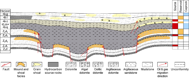
Fig. 9. Sinian-Cambrian source-reservoir-caprock assemblages and lithologic trap models in and around the rift. C2g—Cambrian Gaotai Formation; —C1l—Cambrian Longwangmiao Formation; —C1c—Cambrian Canglangpu Formation; —C1m—Cambrian Maidiping Formation; —C1q—Cambrian Qiongzhusi Formation; Z2d—Sinian Dengying Formation. |
2.2.1. Lithologic traps in the rift
These traps are developed inside the Deyang-Anyue rift and have mainly horst-controlled mounds and shoals of Deng2 Member in the north of the rift and independent corroded mounds and shoals of Deng4 Member in the south of the rift as reservoirs, the mud shale of Maidiping Formation + Qiongzhusi Formation of the Lower Cambrian and argillaceous hydrocarbon source rocks of Sinian Doushantuo Formation and Deng3 Member as source rocks, and argillaceous rocks of Deng3 Member and mud shale of Maidiping Formation + Qiongzhusi Formation as direct caprocks, forming good source-reservoir-caprock assemblage (Fig. 9 ). The argillaceous hydrocarbon source rocks of Deng3 Member and the argillaceous hydrocarbon source rocks of Cambrian Maidiping Formation + Qiongzhusi Formation wrap up the independent horst-controlled mound and shoal reservoir of Deng2 Member and the isolated karst mound and shoal reservoir of Deng4 Member from above and around to form independent stratigraphic-lithologic traps (Fig. 9 ). For example, the lithologic trap gas reservoir of Deng2 Member in Well Pengtan-1, the local anticlinal structure has a trap area of about 90 km2 and trap amplitude of about 200 m. According to log interpretation, the gas-water contact is at -5550 m, and the trap with the contact as interface has an area of 145 km2 and gas column height of 230 m, indicating that the trap is a typical stratigraphic-lithologic one.
2.2.2. Rift margin lithologic traps
Occurring at the rift margin, these traps have mainly platform margin mounds and shoals of Deng2 Member and Deng4 Member as well as the platform margin grain shoals of Canglangpu Formation as reservoirs, mud shale of Deng3 Member, mud shale of Qiongzhusi Formation and mudstone in the upper member of Canglangpu Formation as both hydrocarbon source rocks and direct caprocks. The multiple sets of large-scale source-reservoir-caprock assemblages superimpose at the rift margin (Fig. 9 ). The mound and shoal (grain shoal) reservoirs at the platform margin are mainly sealed off laterally by mud shale and tight layers to form mound and shoal (grain shoal) lithologic traps. (1) In the direction from the platform margin to the rift, the mud shale of Maidiping Formation + Qiongzhusi Formation with massive thickness in the rift is against the reservoirs laterally, sealing or supplying hydrocarbon to the reservoirs (Fig. 9 ). (2) In the direction from the platform margin to the platform, the mounds and shoals (grain shoals) mainly dock with the argillaceous dolomite of restricted platform facies laterally. The argillaceous dolomite is poor in porosity and permeability and very tight, can seal the mounds and shoals laterally (Fig. 9 ). (3) In the direction from the platform margin to the core of the paleo-uplift, tight layers between the mounds and shoals (grain shoals) act as seal layers. Since a series of faults perpendicular to the platform margin developed, dividing the platform margin into a rugged ancient landform, mounds and shoals (grain shoals) developed in the highs of the ancient terrain and tight layers developed in the lows of the ancient terrain, so the tight layers divide the mounds and shoals (grain shoals) into relatively independent geologic bodies[16] surrounded by tight rock bodies, thus forming mound and shoal (grain shoal) lithologic traps. In the early stage of hydrocarbon accumulation, the lithologic traps of this type were high in the structural position, similar to the mounds and shoals in the Gaoshiti-Moxi area, and thus were favorable for oil and gas gathering and accumulation. Due to the late tectonic movement, they are now located in the north slope area of the paleo-uplift and are mainly lithologic traps (Fig. 10 ). For example, the grain shoal gas reservoir of Canglangpu Formation in Well Jiaotan-1 is located in the present slope area. The bottom of Canglangpu Formation gas zone in Well Jiaotan-1 and Well Chuanshen-1 are at -6597.5 m and -7159.5 m respectively, indicating that the reservoirs in these two wells are independent gas reservoirs and sealed by tight lithologic belts between the faults and platform margin grain shoals in the up-dip direction, showing characteristics of structural-lithologic gas reservoir under the slope background.
Fig. 10. Accumulation and evolution model of large lithologic gas reservoirs of rift margin mounds and shoals in the north slope (see |
3. Accumulation models and evolution of large lithologic gas reservoirs
3.1. Accumulation models
3.1.1. Accumulation model of mound and shoal lithologic gas reservoirs in the rift
In the depositional period of Deng4 Member, the Deyang-Anyue rift covered a large area of about 5×10⁴ km2 in Sichuan Basin. The Dengying Formation in the northern part of the rift is mainly composed of Deng1 Member + Deng2 Member, while Deng3 Member and Deng4 Member are very thin or completely missing. The reservoirs are mainly platform margin mounds and shoals of Deng2 Member. Experiencing the second episode of the Tongwan movement[25], the mounds and shoals have turned into good karst reservoirs. Meanwhile, the top surface of Deng2 Member is uneven, forming relatively independent mounds and shoals with different areas in rows (Figs. 1a and 9). Reservoirs of this type are good in quality and relatively independent. The mud shale units of Cambrian Maidiping Formation + Qiongzhusi Formation in the rift are both source rock and cap rock, with a thickness of 200-500 m and a hydrocarbon generation intensity of more than 50×108 m3/km2 generally. The hydrocarbon source rocks envelope the relatively independent mound and shoal reservoirs from above and around, forming stratigraphic lithologic traps. The oil and gas generated by the hydrocarbon source rocks migrate to the platform margin mound and shoal reservoirs from above and around and gather to form pools. Meanwhile, the source rocks of Sinian Doushantuo Formation and Deng3 Member below may supply hydrocarbons to the mound and shoal reservoirs above too. According to seismic prediction, platform margin mounds and shoals of this kind are about 3000-4000 km2, and the largest mound and shoal is about 1000 km2 in area (Figs. 1a and 9).
In the southern part of the rift, the isolated mound and shoal reservoirs of Deng4 Member show chaotic massive reflection and uneven top surface in seismic facies, which are the characteristics of karst weathering crust. The overlying strata show flat and continuous reflections and act as hydrocarbon source rocks of Qiongzhusi Formation with massive thickness. Similar with horst-controlled mounds and shoals of Deng2 Member in the northern part, they combine into a good source-reservoir-caprock assemblage, which can form large-scale lithologic gas reservoirs. Relatively independent, gas reservoirs of this type often uplifted and subsided as a whole in late tectonic evolution, so the oil and gas accumulated in the isolated mounds and shoals can be well preserved.
3.1.2. Accumulation model of mound and shoal lithologic gas reservoirs around the rift of the north slope
The characteristics and functions of the Deyang-Anyue rift are clear [11-12], and the platform margin zones of Deng2 Member and Deng4 Member have also been clearly delineated. The accumulation model of "in situ" cracking of the paleo-oil reservoir in platform mound and shoal complex of Gaoshiti-Moxi region in the core of the paleo-uplift has been proposed [15]. The slope area of the paleo-uplift has platform margin mounds and shoals, reservoirs, hydrocarbon source rocks and caprocks similar to the core of the paleo-uplift, but the slope area was located at the core of the paleo-uplift in the early stage and in the slope in the late stage, where the formation of structural lithologic gas reservoirs is quite different from the Anyue giant gas field. The argillaceous hydrocarbon source rocks of Qiongzhusi Formation in the rift laterally connected with platform margin mounds and shoals of Deng2 Member and Deng4 Member at the rift margin provide abundant gas supply to the reservoirs and act as lateral sealing as well. The mudstone of Qiongzhusi Formation overlying the Deng4 Member acts not only as source rock but also direct caprock. The argillaceous hydrocarbon source rocks of Qiongzhusi Formation in the rift and at the rift margin can provide gas supply to the grain shoal reservoirs in the lower member of Canglangpu Formation at the rift margin above. The argillaceous siltstone of the upper member of Canglangpu Formation can serve as direct caprock to form grain shoal lithologic gas reservoirs (Fig. 9 ). The sealing in the up-dip direction of the slope mainly relies on tight rock bodies. At the rift margin, as tight layers of argillaceous dolomite deposit in the relatively lows of ancient terrain between platform margin mounds and shoals, they can seal the up-dip direction of the platform margin mounds and shoals laterally [16].
3.2. Formation and evolution of accumulations
Comparison of the characteristics of natural gas in the gas reservoirs discovered in Deng2 Member in the rift and Canglangpu Formation at the rift margin of the north slope (Table 1 ) with those in Dengying Formation and Longwangmiao Formation in Gaoshiti and Moxi areas shows [3,9,15] that: (1) The natural gas in Deng2 Member inside the rift and in Canglangpu Formation at the rift margin of the north slope is mainly derived from mud shale of Cambrian Maidiping Formation and Qiongzhusi Formation, and the Sinian argillaceous hydrocarbon source rock and carbonate hydrocarbon source rock also made some contribution. (2) The natural gas is mainly crude oil cracking gas, which may have similar formation and evolution characteristics to the gas in the Sinian and Cambrian of Gaoshiti-Moxi area [3,15,28⇓⇓⇓⇓ -33].
Table 1. Characteristics of natural gas from Deng2 Member of Well Pengtan-1 and Canglangpu Formation of Well Jiaotan- 1[33] |
| Pay zone | Well name | Contents of gas components/% | δ13C/‰ | δ2H/‰ | |||||||
|---|---|---|---|---|---|---|---|---|---|---|---|
| C1 | C2 | CO2 | N2 | He | H2 | H2S | CH4 | C2H6 | CH4 | ||
| Deng2 Member | Pengtan-1 | 96.82 | 0.18 | 1.30 | 1.70 | 0 | 0 | 0 | –38.2 | –36.4 | –134 |
| Canglangpu Fm. | Jiaotan-1 | 92.83 | 0.07 | 4.42 | 0.56 | 0.01 | 0 | 2.11 | –34.7 | –29.0 | –140 |
The horst-controlled mounds and shoals of Deng2 Member and isolated karst mounds and shoals of Deng4 Member in the rift are closely surrounded by Cambrian source rocks, forming independent hydrocarbon accumulation systems. The liquid hydrocarbons generated by mature source rocks entered the mound and shoal reservoirs from multiple directions to form oil reservoirs. As this area had few faults developed and overall vertical movement in the later period, the oil reservoirs have been surrounded by the mound and shoal reservoirs, cracked into gas reservoirs, and preserved to the present.
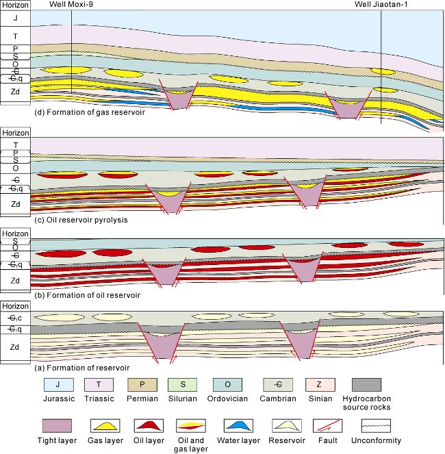
The reservoir forming process of the platform margin mounds and shoals in Deng2 Member and Deng4 Member of Gaoshiti-Moxi region at the rift margin has been made clear [3,29⇓⇓ -32]. The platform margin mounds and shoals (grain shoals) of Deng2 Member, Deng4 Member and Canglangpu Formation in the north slope have basically the same reservoir forming conditions and natural gas source as those in the Gaoshiti-Moxi region, but are consistent in early and middle stages but different significantly in the later stage in structural evolution process. Hence, they have both similarities and differences in reservoir formation and evolution. The reservoir formation can be divided into four stages. (1) Reservoir formation stage. When the reservoirs were formed, the whole area high in terrain at the platform margin had high water energy and largely microbial mound and shoal and grain shoal deposits, which underwent interlayer karstification etc. to form high-quality mound and shoal reservoirs with similar characteristics; while in the low terrain zones with low water energy, argillaceous dolomite (limestone) with high argillaceous content deposited, which has evolved into tight rock bodies through diagenesis, dividing the platform margin mounds and shoals or grain shoals into multiple relatively independent large mound and shoal (grain shoal) reservoirs. The large-scale reservoirs formed at the whole platform margin are similar in characteristics and relatively independent (Fig. 10 a). (2) Oil reservoir formation stage. Through simulation of "three histories" including the burial history and hydrocarbon source rock evolution history of Wells Gaoshi1 and Well Moxi-8 [3,9], it is found that there was a peak of hydrocarbon generation before and after the Permian deposition respectively, when a large amount of liquid hydrocarbon was generated and made into the reservoirs to form oil reservoirs. As the reservoirs and permeable rock bodies are relatively independent, the oil reservoirs formed are also relatively independent (Fig. 10 b). In the stage of oil reservoir formation, the mounds and shoals in the entire platform margin can form reservoirs on the whole. (3) Stage of oil reservoirs cracking into gas reservoirs. Through "three-history" experimental simulation, it is concluded that in the Jurassic, the oil reservoirs began to crack into gas reservoirs massively. As the tectonic movement in this area was mainly overall subsidence, the oil reservoirs completely cracked into gas reservoirs basically in the same period (Fig. 10 c). (4) Formation, preservation and transformation stage of gas reservoirs. After the deposition of Jurassic, almost all the oil reservoirs had cracked into gas reservoirs. The Himalayan tectonic movement transformed the study area intensively, as a result, the Weiyuan region uplifted significantly, forming the present structural features of high in the middle and low on both flanks. Except for the Gaoshiti-Moxi region and Weiyuan region which are located at structural highs, the other areas in the study area are slope areas. During Himalayan tectonic movement, the gas reservoirs were reformed and destroyed to some extent. As most of the area has no large fault, the direct cap-rock conditions of the gas reservoirs are good, and the lateral sealing of tight layers is strong, the individual gas reservoirs of platform margin mounds and shoals have been preserved completely and independently to the present (Fig. 10 d), and multiple large lithologic gas reservoirs with large differences in gas-water contact turn up in the slope area [16]. For example, the gas-water contact of the gas reservoir of Deng4 Member in Well Jiaotan1 in the north slope is at -7230 m, while the gas-water contact of the gas reservoir of Deng4 Member in the Gaoshiti-Moxi region is at -5230 m, that is a difference of 2000 m in altitude.
4. Favorable exploration zones and prospects
By analyzing the characteristics and reservoir-forming mechanism of the horst-controlled mound and shoal reservoirs and mound and shoal/grain shoal reservoirs at the platform margin in and around Deyang-Anyue intracratonic rift, the distribution of favorable large-scale reservoirs has been predicted and evaluated. Combined with the distribution characteristics of hydrocarbon source rocks and caprocks as well as characteristics of structural evolution and gas reservoir evolution etc., six favorable zones of two types in the rift and around the rift have been sorted out comprehensively.
4.1. Favorable zones in the rift
4.1.1. Favorable zone for stratigraphic and lithologic gas reservoirs in Deng2 Member in the north part of the rift
Based on detailed analysis of the tectonic and sedimentary environments during the development of the rift, it is concluded that multi-stage platform margin and platform margin mound and shoal reservoirs developed in the rift in the depositional period of Deng2 Member. The mounds and shoals and reservoirs are similar in characteristics to the platform margin mound and shoal sedimentary reservoirs at the rift margin in the Gaoshiti-Moxi region. Surrounded by the hydrocarbon source rock of Cambrian, the horst-controlled mounds and shoals of Deng2 Member in the rift can form reservoirs on a large scale. Based on fine interpretation of 2D and 3D seismic data, it is estimated that the horst-controlled mounds and shoals of Deng2 Member are about 1000 km2 in the Penglai region and 2000-3000 km2 in other regions of the rift (Fig. 8I -1). With good reservoir forming conditions, it is estimated that they have resource potentials of over 5000×108 m3.
4.1.2. Favorable zone for stratigraphic and lithologic gas reservoirs in Deng4 Member in the southern part of the rift
The isolated karst mounds and shoals of Deng4 Member in the southern part of the rift were predicted with seismic data, and nine karst mound-shoal bodies with an area of about 2000-3000 km2 were selected (Fig. 8I -2). Due to karstification of the weathering crust, the karst mounds and shoals have turned into good karst reservoirs. Surrounded by Cambrian source rock, the relatively independent karst mound and shoal reservoirs may form large-scale gas reservoirs. During the late tectonic movement, the area basically rose and fell as a whole, so the oil and gas reservoirs formed in the early stage can be preserved up to the present, with estimated resource potentials of about 3000×108 m3.
4.2. Favorable zones for platform margin mounds and shoals at the rift margin
4.2.1. Favorable zone with multi-target layers in the north slope
With the exploration of Anyue giant gas field, the platform margin mounds and shoals of Dengying Formation at the core of Gaoshiti-Moxi paleo-uplift have been clearly delineated and their development characteristics in the northward and southward platform margin zone also have been figured out basically. Based on the examination of a lot of seismic data, the platform margins of Deng2 Member and Deng4 Member in the north slope of the paleo-uplift were carefully evaluated. Compared with the core area of the paleo-uplift, the platform margin of Deng4 Member becomes wider from 10-15 km to about 20-30 km and increases in thickness too [15]. The platform margins of Deng2 Member do not coincide with that of the Deng4 Member. The platform margin mounds and shoals of Deng2 Member are located in the rift of the depositional period of Deng4 Member, and the burial depth of its top is about 300 m deeper than the top surface of Deng4 Member (Fig. 8II -1). In the reservoir-forming and main petroleum accumulation period, the platform margin mounds and shoals of Deng4 Member in the north slope have similar paleostructural characteristics with those in the Gaoshiti-Moxi region at the core of the paleo-uplift. In the up-dip direction of the platform margin, affected by the near east to west trending faults, multiple tight zones develop in the platform margin of Deng4 Member, dividing the platform margin into multiple independent mounds and shoals. The independent mounds and shoals formed reservoirs in the same period and have been preserved independently[16]. In the north slope, several mounds and shoals have been identified in Deng4 Member, among which, Yanting mound-shoal covers an area of 2760 km2. The mounds and shoals have an overlapping area of more than 2×10⁴ km2 and the resources scale of more than 2×10¹² m3.
4.2.2. Platform margins of Deng2 Member and Deng4 Member on the west side of the rift
The platform margin mounds and shoals of Deng2 Member and Deng4 Member developed on the west side of the rift. The platform margin of Deng2 Member is located in the rift of the depositional period of Deng4 Member (Fig. 8II -2). As the platform margin is gentle, the mounds and shoals are smaller. A total of seven wells were drilled in Ziyang region, and 3 wells, Well Zi-1, Well Zi-2 and Well Zi-3 obtained industrial gas flows, among them, Well Zi-2 had a gas flow of 11.3×10⁴ m3/d, indicating that this area also has substantial exploration potential. The platform margin of Deng4 Member is located near the southern boundary of the basin (Fig. 8II -3). The top of the Dengying Formation has structural traps developed, but mainly Himalayan structures. The drilled wells revealed that this area has reservoirs developed, but with high water cut, for example, Well Hanshen-1, Well Laolong-1 and Well Woshen-1. Preservation conditions in the area are crucial.
4.2.3. Southern section of the platform margin of Deng4 Member on the east side of the rift
Platform margin mounds and shoals in the southern section of the platform margin of Deng4 Member on the east side of the rift (Fig. 8II -4) have reservoir characteristics, reservoir forming conditions and evolution process similar to those in the north slope (northern part) and Gaoshiti-Moxi region (middle segment) [16]; and Well Heshen-2 tapped a high yield gas flow of 20×104 m3/d, indicating that this area has large exploration potential.
4.3. Exploration prospect
The breakthrough of Well Pengtan1 proves that lithologic gas reservoirs with large-scale can be formed in the horst-controlled mounds and shoals of Deng2 Member in the rift. It is predicted that there are two to three rows of horst-controlled mound and shoal strips in Deng2 Member controlled by faults in the rift, with a total area of 2000-3000 km2. The mound and shoal complex where Well Pengtan1 is located is about 1000 km2 with potential resources of about (3000-5000)×108 m3, showing huge exploration potential. Well Jiaotan1 reveals that the north slope of Gaoshiti-Moxi paleo-uplift has multiple gas-bearing platform margin mound and shoal bodies, suggesting this area has substantial exploration potential. According to seismic data, in the area of Well Jiaotan1, the platform margin mounds and shoals of Deng4 Member are about 2760 km2, the 9 grain shoals of Canglangpu Formation are about 2300 km2, and the 3 shoals of Maokou Formation are about 2560 km2, and with the total potential resources of about 1×10¹² m3.
There are several sets of reservoirs in and around the rift, including 4 sets of pore-type reservoirs, Deng2 Member, Deng4 Member, Canglangpu Formation and Longwangmiao Formation. The hydrocarbon source rock of Cambrian in the rift is 150-450 m thick. With source rock and reservoirs, providing good oil and gas accumulation conditions. Several wells, including Well Jiaotan1 and Well Pengtan1, have obtained high yields, foretelling huge exploration potential of this area. Therefore, the Sinian-Cambrian system in and around the rift is an important frontier for searching oil and gas and large-scale reserves in the future. A large prospective with large lithologic gas reservoirs in multiple strata has been on the horizon, and it is expected to discover a giant gas province with reserves of (2-3) ×1012 m3 in the future.
5. Conclusions
Different types of large reef shoals were developed in different periods in the Deyang-Anyue intracratonic rift. In the development period, multiple sets of faults were developed in the rift, forming the multi-row horst-controlled reef beach facies belts of Member Deng2. In the progressive stage, large-scale platform margin reef beach facies belts of Member Deng4 were developed in the rift margin. Due to the weathering crust karstification, isolated reef shoals of Member Deng4 were developed in the rift; in the shrinkage stage, the platform margin carbonate shoals of Canglangpu Formation were developed in the east of the rift.
Four sets of large-scale mound and shoal reservoirs namely, Deng2 Member, Deng4 Member, Canglangpu Formation and Longwangmiao Formation overlap in large areas with the hydrocarbon source rocks of Qiongzhusi Formation and argillaceous limestone (dolomite) of Dengying Formation in and out of the rift, forming good source-reservoir-caprock assemblages. Sealed by inter-shoal tight lithologic bodies laterally and in the up-dip direction, large lithologic gas reservoirs preserved independently are formed from cracking of oil in the original reservoir.
Six favorable exploration zones for large lithologic gas reservoirs have been sorted out from comprehensive evaluation, namely, the horst-controlled mounds and shoals of Deng2 Member in the north part of the rift, isolated karst mounds and shoals of Deng4 Member in the south part of the rift, platform margin mounds and shoals of Deng2 Member, Deng4 Member and Canglangpu Formation in the north slope on the east side of the rift, and the platform margin mounds and shoals of Deng2 Member and Deng4 Member at the western margin of the rift. Well Pengtan-1 and Well Jiaotan-1 tested high yield gas flows in multilayers, marking exploration breakthroughs in two favorable zones. It is expected to discover a giant gas province with reserves of (2-3)×1012 m3 in the future in this area.