

Introduction
The oil and gas exploration in the Bohai Bay Basin has entered into a medium-to-high maturity stage, and it is more and more difficult to find large-scale oil and gas reservoirs. When conducting oil and gas exploration in deep and ultra-deep layers, as well as marginal depression, the traditional shallow layers (in this paper it mainly refers to the Neogene Minghuazhen Formation with buried depth of 1000-2000 m) will continue to be the crucial areas for exploration to increase reserves and production due to their advantages of shallow burial depth, good physical properties, high productivity and good economic benefits [1⇓⇓-4]. The oil and gas exploration in the shallow layers in the Bohai Sea has experienced multiple stages of exploration, including structural exploration, structural-lithological exploration and lithological exploration. The shallow reservoirs are getting smaller in scale, and more fragmented, and the proven geological reserves of single reservoir are mostly less than 50×104 m3. Considering economic benefits, finding shallow large-scale and high-quality reservoirs has become a key research direction [5⇓⇓⇓⇓⇓-11]. With the deepening of research and exploration practice, a series of crucial geological understandings have been formed, and new exploration technologies have been developed, including the geological understanding about the fluvial-lacustrine sedimentary characteristics of the shallow layers during depression period, river-lake interbedded sedimentary model in depression period [1,4,6],hydrocarbon accumulation mechanisms in large-area lithological traps in fluvial-lacustrine interbedded sedimentary facies, and reservoir description technology [8,12 -13], identification technology of implicit faults [14-15], extra-source hydrocarbon migration and accumulation mechanisms dominated by deep "convergence ridge" [2,14]. With the application of the above geological understanding and key technological innovations, a number of shallow oil and gas fields with reserves of hundred million tons have been discovered successively in lithological traps around the Bozhong sag, such as QHD33-1S [1,7], KL6-1 [13,16 -17] and KL10-2, indicating that there is great exploration potential for finding oil and gas in large-scale lithological traps in shallow layers. Previous studies have focused on the key problems of hydrocarbon accumulation mechanisms and exploration technology. In this study, based on a large number of drilling, seismic, and testing data, combined with exploration practice, we systematically analyze the differences in hydrocarbon accumulation mechanisms in shallow large-scale lithologic traps in Bozhong region, and study the main controlling factors for hydrocarbon enrichment, and establish the hydrocarbon enrichment model. The study results are helpful for finding the subsequent exploration targets, and can provide reference for the exploration of similar reservoirs outside the source.
1. Basic regional geology
1.1. Tectonic and sedimentary evolution around Bozhong sag
Located in the center of the Bohai Bay Basin, the Bozhong Rim region includes several secondary structural units, mainly Bozhong sag, Shijiutuo uplift, Shaleitian uplift, Bonan low uplift, Laibei low uplift and Huanghekou sag (Fig. 1 ). Controlled by the Indosinian and Yanshan tectonic movements in the Mesozoic, the fault systems were mainly developed in three directions, namely northeast, northwest and east-west. During the Early Cenozoic, the activation of these pre-existing faults controlled the formation of the initial fault depression in the basin, forming the structural pattern of multi sags and multi uplifts [18⇓⇓-21]. Various types of sedimentary systems were developed, and a large number of "convergence ridges" were formed (convergence ridge refers to the deep geological body with ridge shape under the shallow trap, with permeable layers in the surface or interior of the geological body, which are communicated with the source rocks in large-area) [22-23]. In the Late Cenozoic, the area entered into the evolutionary stage of thermal subsidence, forming a unified depression [20]. During the initial rifting stage, the Paleogene Kongdian Formation to the Sha-4 Member of the Shahejie Formation were deposited. During the depositional period of Sha-3 Member of the Shahejie Formation, the basin entered into strong rifting stage, and thick lacustrine mudstones were widely deposited, forming important source layers in the Bohai Bay Basin, with organic matter maturity (Ro) exceeded 2.0%[24-25]. After regional uplifting and denudation during the late depositional period of the Sha-3 Member of the Shahejie Formation, the basin entered into the fault-depression transition stage, which was the maximum flooding period in the Bohai Sea. During this depositional period, a set of thin stratum of Eocene Sha-1 and Sha-2 members of the Shahejie Formation were widely deposited, and overlapped on the slopes of uplift and low uplift, which were also a set of regionally stable oil-generation layers. During the Oligocene, the basin entered into the third stage of rifting, and the thick Dongying Formation was deposited, which was large and stable in thickness, and deep in burial depth, also being a set of potential source rock [26]. After the deposition of the Dongying Formation, the basin experienced regional uplift and denudation, and entered into the evolutionary stage of depression and thermal subsidence in the Neogene. During this period, the Bozhong area was the final depositional center of the Bohai Bay Basin, and a number of confined atrophic lacustrine sub-basins dominated by river-lake interbedded sedimentary systems. The notable feature is that the fluvial facies sandstone, extremely shallow water delta sandstone and lacustrine mudstone form a thick set of reservoir-cap assemblages [27]. The Neogene reservoir was characterized by shallow burial depth, good physical properties (with average porosity of 25%), wide distribution and moderate thickness. The mudstone was stable in distribution. In the Bozhong sag, controlled by the strike-slip faults of Tanlu and Zhangpeng [28⇓-30], faults were highly developed during Neogene, which acted as the vertical hydrocarbon migration channels, resulting in hydrocarbon accumulation outside the source in the shallow layers.
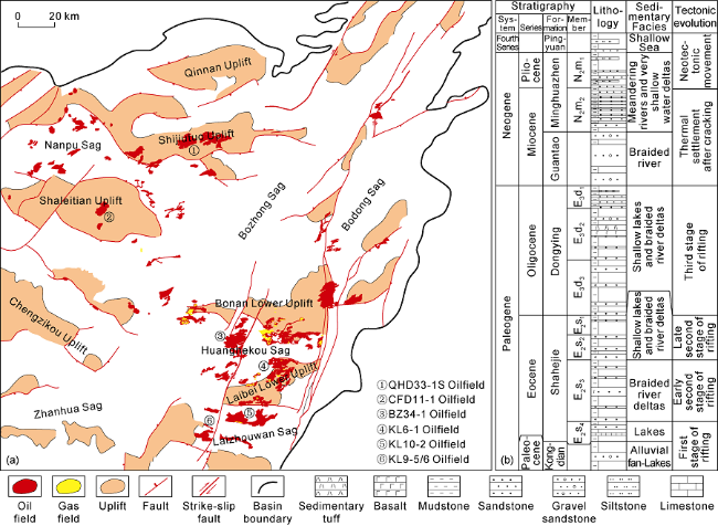
Fig. 1. Distribution of typical shallow oil and gas fields (a) and comprehensive stratigraphic column (b) around the Bozhong sag. |
1.2. Reservoirs in shallow strata around Bozhong sag
The shallow reservoirs (Minghuazhen Formation) around Bozhong area have a large quantity of reserves, being good in physical properties and high in productivity [5]. By the end of 2021, the proven geological reserves around the Bozhong area were 16.46×10⁸ t oil equivalent, of which the proven geological reserves in the Lower Member of Minghuazhen Formation were 15.69×10⁸ t. Among the discovered shallow reservoirs, there are 7 large to extra-large oil and gas fields (the proved geological reserves are greater than 1.0×10⁸ t), and the proven oil and gas geological reserves are 8.51×10⁸ t oil equivalent, accounting for 51.7% of the total proven oil and gas geological reserves in shallow layers. There are 6 large and medium-sized oil and gas fields (the proved geological reserves are 0.5×10⁸ t to 1.0× 10⁸ t), with proven oil and gas geological reserves of 3.48×10⁸ t oil equivalent, accounting for 21.1% of the total proven oil and gas geological reserves in shallow layers. There are 6 medium-sized oil and gas fields (the proved geological reserves are 0.3 ×10⁸ t to 0.5 ×10⁸ t), with proven oil and gas geological reserves of 1.98×10⁸ t oil equivalent, accounting for 12% of the total proved oil and gas geological reserves in shallow layers. The shallow oil and gas reservoirs are dominated by structural, structural-lithologic and lithologic traps, among which the lithologic-related reserves are 11.93×10⁸ t oil equivalent, accounting for about 72.5% of the total reserves.
It has been proved by exploration in recent years that the newly discovered reservoirs in the Lower Member of Minghuazhen Formation have gradually turned into reservoirs in lithological trap, large in area, continuous in oil-bearing area, with higher reserves abundance and large-scale reserves (the large-scale reserves in this paper generally refer to the reserves of a single sand body exceeding 500×104 t) (Table 1 ). The large-scale lithologic reservoirs are mainly distributed in the overlapped lobe-type and channel-type sand bodies in the Lower Member of Minghuazhen Formation.
Table 1. Basic characteristics of large oil and gas fields in the Lower Member of Minghuazhen Formation around the Bozhong area |
| Typical oil field | Discovery time | Reservoir type | Lithologic trap | Reservoir properties | Density/ (g•cm-3) | Proved reserves of oil field/104 t | Produc- tion/m3 | ||
|---|---|---|---|---|---|---|---|---|---|
| Area/km2 | Number of main trap | Proved reserves/ 104 t | |||||||
| CFD11-1 | 1998 | Lithologic- structure | 25.3-25.4 | 9 | 9756.40 | Extra-high porosity and permeability | 0.958-0.972 | 14 979.34 | 263.59 |
| BZ28-34 | 2003 | Lithologic- structure | 19.2-30.8 | 16 | 7429.80 | Extra-high porosity and permeability | 0.858-0.921 | 9790.69 | 95.00 |
| QHD33-1S | 2011 | Lithologic | 130.4-278.6 | 5 | 5605.17 | Extra-high porosity and permeability | 0.904-0.999 | 9850.88 | 85.44 |
| KL6-1 | 2018 | Lithologic | 89.6-230.0 | 3 | 8529.60 | High porosity and high- medium permeability | 0.906-0.939 | 10 627.33 | 187.28 |
| KL10-2 | 2020 | Lithologic | 109.6-257.0 | 7 | 7268.65 | High porosity and high- medium permeability | 0.964-0.981 | 10 844.15 | 84.72 |
The Minghuazhen Formation in the Bohai Sea was deposited at the relative lake expansion stage of the lake shrinking period [6,27]. The basin was characterized by gentle topographic slop, with shallow water and sufficient source supply, and was great influenced by the change of lake level. As the depositional center of the Bohai Bay Basin, The Bozhong area in the Late Neogene was in a river-lake alternated sedimentary environment, where the extremely shallow water delta deposits were frequently interbedded with fluvial deposits. The reservoir-cap assemblage is mainly composed of fluvial and extremely shallow water delta sandstones and thick lacustrine mudstone [6⇓⇓⇓⇓⇓⇓⇓⇓⇓⇓⇓⇓⇓⇓⇓⇓⇓⇓⇓⇓-27]. During the depositional period of the Lower Member of Minghuazhen Formation, there were several periods of secondary lake flooding. Controlled by the combined hydrodynamic forces of river and lake, overlapped and continuous lobe-type and channel-type lithologic traps with large areas were easy to formed [4,13,31]. The overlapped lobe-type sand bodies were generally developed in the area of extremely shallow water delta, where the delta front was strongly reformed by lake wave to be less channeled, lobe-shaped and overlapped with large areas (Fig. 2 ). The main channel was relatively poor developed. The channel-type lithologic sand bodies were widely distributed, and developed in fluvial facies and extremely shallow water deltas [4,13]. When the lake force was weak, it was obvious that multi-channels were locally cross-cutting, and the bifurcation phenomenon was not obvious generally. In the areas where the lake force was strong, the channel sand bodies were obviously reformed to be sheet-shape, and the densely interlaced distributary channels were developed, forming a "network" on the plane, and were widely distributed in large area. It might reach hundreds of square meters, and the main channel sand bodies might occupy a high proportion on the plane (Fig. 2 ). The average thickness of the sand body was 5-15 m, and the thickness changed greatly in plane. The main channel is generally 8-20 m in thickness, and the sheet-shape sand is 3-8 m in thickness. The reserves of a single sand body are large, and can reach tens of millions of tons.
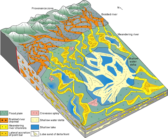
Fig. 2. Sedimentary system distribution of overlapping contiguous sand bodies in the Lower Member of Minghuazhen Formation of Bozhong area. |
The reservoirs of lithologic traps in the Lower Member of Minghuazhen Formation are shallow in burial depth, with good homogeneity and favorable physical properties, having high porosity and medium-high permeability to ultra-high porosity and permeability. The porosity is in range of 15.6%-40.5%, and the permeability is between 8 to 5765.2×10-3μm2. The crude oils are good in physical properties, mainly medium-heavy oil, with the density of 0.858-0.999 g/cm3 (20 °C). The productivity was high during production test, with daily production of 80-100 m3/d, and the highest daily production of 263.59 m3/d (Table 1 ).
2. The dominant controlling factors of hydrocarbon accumulation in shallow buried large-scale lithologic trap
The dominant controlling factors of hydrocarbon accumulation in shallow layer large-scale lithologic trap consist of four elements, including ridge, ridge-cutting faults, sand bodies and sealing fault zone. A ridge refers to a deep-buried convergence ridge [23,32⇓ -34]. A ridge-cutting fault refers to a vertical migration fault which cut the convergence ridge and was active during the hydrocarbon accumulation period [31]. Sand bodies refer to a large area of shallow buried sand bodies which were connected by the ridge cutting fault in long distance [12,35]. A sealing fault zone refers to a complicated fault zone in the stress concentration zone, formed by the stress transformation in hydrocarbon migration direction in shallow layers, and the lithologic trap was effectively sealed.
2.1. The converging capability of the deep-buried convergence ridge is the basis for hydrocarbon enrichment in shallow layers
The "convergence ridge" in the deep layer emphasizes the permeability of the ridge geological body[23], which refers to a low potential area and the "termination" area of deep lateral migration of oil and gas, which influenced the hydrocarbon accumulation by the function of both "convergence" and "accumulation". The convergence ridge is classified into with two types based on its characteristics: (1) The convergence ridge acts as the migration and accumulation path (unconformity surface, sand body and fault), which communicate the hydrocarbon from the source rock to migrate and converge from the surrounding area to the low potential area for a long time. (2) The convergence ridge acts as the termination area for the lateral migration of oil and gas in the deep layer. When the fault activity connected the deep and shallow layers on the convergence ridge, oil and gas migrated vertically to the shallow layer along the combined channel of fault and sand body, and accumulated, forming a shallow oil and gas reservoir. If the reservoir space of the convergence ridge geological body is large enough (such as the sand body in the steep slope zone), it could form deep reservoir, which controlled the enrichment of shallow oil and gas. If the convergence ridge geological body did not have enough reservoir space (such as unconformity), thus it mainly controlled the migration and accumulation of shallow reservoirs. Exploration practice in the Bohai Sea has proved that only when there is a convergence ridge in the deep layer, oil outside the source in the shallow layer could have the possibility for hydrocarbon enrichment and accumulation.
The hydrocarbon enrichment in shallow layers was firstly controlled by the existence of a coupling convergence ridge which set off the primary migration of the deep source rocks. The convergence ridges around the Bozhong area can be classified into the steep slope sandstones type, the hidden low uplift type, the high uplift type and the rise in sag type [23] (Fig. 3 ). The deep buried convergence ridge controlled the hydrocarbon enrichment in shallow layers by playing the “warehouse” role [34], providing hydrocarbons and dynamic for the abundant reservoir in shallow layers. The converging capability of the deep-buried convergence ridge controlled the hydrocarbon enrichment in shallow layers. This converging capability was determined by the ridge’s contact area with the hydrocarbon source rocks and the dip angle and area of the converging ridge, which could be quantitively, described using an oil accumulation index[16]. The statistical data of the hydrocarbon reserves in shallow layers around the Bozhong area and the oil accumulation index of the convergence ridge indicated that these two factors shared positive correlation (Table 2 ). The more capable the convergence ridge was, the larger the hydrocarbon reserves in shallow layers were.
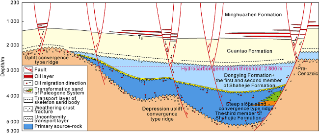
Fig. 3. Convergence ridge types and shallow oil and gas distribution in Bozhong Area (modified from Reference [31]). |
Table 2. Convergence capacity in the deep layer and reserve distribution in the shallow layer of Bozhong sag of the Bohai Sea |
| Oil field | Contact length between convergence ridge and source rock/km | Convergence ridges and source rocks contact area/km2 | Angle of convergence ridge/(°) | Area of convergence ridge/km2 | Oil accumulating index | Reserve in shallow layer/104 t |
|---|---|---|---|---|---|---|
| BZ28-34 | 12.71 | 128.3 | 13.0 | 62.90 | 180.06 | 9790.69 |
| KL7-6 | 9.38 | 46.1 | 13.8 | 26.40 | 59.07 | 2048.00 |
| BZ13-1 | 9.05 | 54.2 | 7.4 | 57.40 | 66.90 | 2470.20 |
| BZ8-4 | 13.07 | 170.4 | 20.2 | 49.90 | 225.19 | 5757.00 |
| CFD12-6 | 19.75 | 70.8 | 21.0 | 69.30 | 490.48 | 6560.00 |
| BZ34-1 | 15.78 | 193.5 | 5.8 | 106.70 | 170.75 | 9862.00 |
| KL6-1 | 23.30 | 229.0 | 8.3 | 123.00 | 413.70 | 14 484.00 |
| KL10-2 | 19.60 | 178.7 | 9.7 | 89.70 | 519.51 | 10 844.00 |
| Shaleitian uplift | 57.32 | 204.6 | 10.7 | 606.11 | 6450.28 | 40 700.00 |
| Shijiutuo uplift | 63.90 | 674.9 | 18.5 | 650.44 | 9702.44 | 43 900.00 |
| PL9-1 | 34.77 | 376.9 | 7.8 | 264.39 | 1252.34 | 22 247.00 |
2.2. The activity intensity of the ridge-cutting faults and the thickness of the contact faulted mudstone controlled the vertical hydrocarbon migration
For the shallow outside-source-rock hydrocarbon accumulation system, the Neogene sandstones were not directly contacted with the source rocks, thus the vertical transport capacity of the fault controlled the hydrocarbon accumulation in shallow layers. According to the exploration practice, not all the faults were able to transport hydrocarbon vertically, only the deep cut faults which cut into the convergence ridge could transport hydrocarbon vertically in large amounts [16]. The larger contact area between the fault and the ridge was, the more active the fault was, the more capable its transportation was, and the richer the hydrocarbon accumulated in shallow layers. As the coupling relationship of the convergence ridge with the large faults was the basic condition, the vertical transport capacity of the fault was also influenced by the thickness of the cap rock [16,36]. There were two layers of steadily widespread mudstone around the Bozhong area. One of them was the lacustrine mudstone of the middle-lower member of Dongying Formation, about 440 m thick on average. The other was the lake shore mudstone of the middle-lower member of Minghuazhen Formation, about 230 m thick on average.
The thickness of the contact faulted mudstone meant that after the cap rock was faulted, part of the mudstone on both side of the fault remained contact, the thickness of this contact part could be used to describe the fault’s destruction to the cap rock and therefore represent the vertical transport capacity [36] (Fig. 4 ). Around the Bozhong area, the statistical data of the fault-ridge coupling, the activity intensity of the faults, the thickness of the contact faulted mudstone and the hydrocarbon reserves in shallow layers showed that the hydrocarbon reserves were mainly distributed in deep layers if the thickness of the contact faulted mudstone was over 300 m, while the hydrocarbon reserves were mainly distributed in shallow layers if the thickness of the contact faulted mudstone was less than 300 m. Besides, the contact area of the oil-source fault with the convergence ridge was positively correlated with the reserves. When the fault throw of the oil-source fault was over 100 m, the vertical transport capacity of the fault was greater, helping the hydrocarbon accumulation in shallow layers.
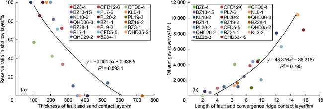
Fig. 4. Relationship between the thickness of fault and sand contact layer (a), length of fault and convergence ridge contact layer (b) and the distribution of shallow oil and gas reserves. |
2.3. The large-scale sandstones coupled with the ridge- cutting fault controlled large-scale hydrocarbon charging
After the hydrocarbon migrated into the shallow layers through the vertical transport faults, it could only accumulate by entering the contact sandstones. The contact between the sandstones and the ridge-cutting fault was important. Previous studies suggested that the larger contact area between the transport fault and the sandstones in shallow layers was, the easier the hydrocarbon migrated laterally[9], which could be evaluated using the contact area [35]. In the Bozhong area, the statistical data of the oilfields showed that the fault-sandstone contact area was positively correlated to the hydrocarbon column height (Fig. 5 ). In the KL 5-1-A area, as the fault-sandstone contact area was 5.76 m·km, the hydrocarbon column height was only 13 m. In KL 6-1-C area, as the fault-sandstone contact area was up to 46.6 m·km, the hydrocarbon column height was as high as 85 m.
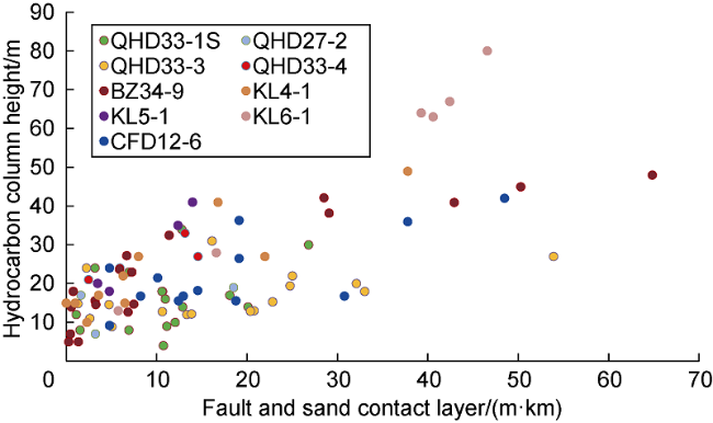
Fig. 5. Sand and fault contact area and hydrocarbon column quantitative characterization in the shallow layer reservoir of the Lower Member of Minghuazhen Formation of Bozhong sag. |
In the meanwhile, the favorable hydrocarbon accumulation spot was also controlled by the scale and shape of the sandstones. Limited by permeability, hydrocarbon was firstly charged into the large sandstones among the mudstones. The connectivity and continuity of the sandstones then controlled the planar hydrocarbon charging. A large area lithologic trap would vary in connectivity, which was influenced by the lateral thickness changes and the continuity of the overlapping sandstones. The hydrocarbon accumulated in a larger scale where the sandstones were better connected. The hydrocarbon accumulated at the structural high rather than the structural low when the sandstones were poorly connected. The conventional attributes could be used to predict the thickness and connectivity of the sandstones, if the studied area was characterized by well-developed sandstone-mudstone suits and the high resolution of seismic data [12]. As shown in Fig. 6 , in the No.1 sandstone lithologic trap of the KL 10-2 oilfield, the sandstones of the KL 10-A area were widely contacted with the dominant transport fault, and the hydrocarbon accumulated in priority. However, in the KL 10-F area where the sandstones were poorly connected and did not contact with the oil source fault directly, the hydrocarbon did not accumulate.
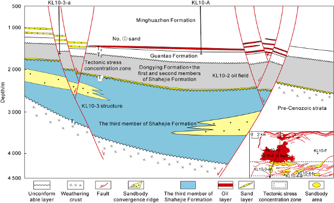
Fig. 6. Relationship between sand bodies and main migration faults in Well KL10-A of KL 10-2 Oilfield. |
2.4. The sealing capability of the faults in the structural stress conversion zone controlled the hydrocarbon enrichment
The ridge-cutting faults coupled with the Minghuazhen sandstones were favorable lateral hydrocarbon migration paths [5]. Whether the hydrocarbon accumulated after entering the sandstones were determined by the sealing conditions. The sealing capability to oil and gas is mainly controlled by the sealing capability of complex fault transition zone formed by compressive stress in the updip pinch-out direction. It has been proved by exploration practice that in updip pinch-out direction near fault zone under compressive background, due to the influence of the compressive stress, formation deformation was very serious, and fault twist activity occurred frequently among fault zones, which enhanced mudstone smear effect, resulting in the strong sealing capability near the fault zones. When oil and gas migrated to this place along the sand bodies, hydrocarbons were blocked by the fault zone, and then accumulated, resulting in formation of reservoirs. This type of reservoir has large oil column height, being the important place for hydrocarbon enrichment (Fig. 6 ). The stress concentration zone might be at the large depression-controlled boundary fault, where the faulting activity was intense, although fewer in numbers, and efficient sealing conditions could be formed under a compressive background. A stress conversion zone could also be the outer belt of the fracture zone of a flower structure under the influence of the later tectonic movements (such as the KL 10-3 structure in Fig. 6 ), where the faulting activity was poor in continuity, providing strong sealing due to their twisted characteristics which was formed as a result of compression stress concentration. Along the dominant migration direction, the hydrocarbon would be stopped and sealed in the lithologic trap at the first row of fault belt with stress concentration (such as the KL 10-2 Oil Field), and accumulated with high abundance. Although in the shallow layers of large-scale lithologic reservoirs of the QHD 33-1S structure, the QHD 32-6 structure, the CFD11-1 structure and the BZ28-34 structure, structural traps were not developed, but they were located on uplifts, with structural background [1,7,32], being favorable for hydrocarbon accumulation. However, the KL 10-2 structure, the KL 6-1 structure, the KL 9-5 and the LK14-5 structure [4,13,17], located on low uplifts without structural traps or a favorable structural background, were characterized by large area of overlapping lithologic traps, and the lithologic reservoirs mainly developed in the lithologic pinch-out traps of the southern stress conversion zone.
3. Hydrocarbon accumulation models in shallow layers of large scale lithologic reservoirs
Four key reservoir accumulation factors, including ridge-fault-sand-zone are taken into consideration. The source-sink-ridge system has been recognized as the main controlling factor for hydrocarbon accumulation. Three types of shallow hydrocarbon accumulation models have been established.
3.1. Hydrocarbon accumulation in sand bodies at steep slope belt
The hydrocarbon accumulation model in sand bodies at steep slope belt is a newly discovered large-scale hydrocarbon accumulation model in shallow layers of the Bohai Sea area in recent years. The subtle faults communicate with deep mature source rocks of Shahejie Formation. The oil and gas migrated primarily from the mature source rocks of deep Paleogene Shahejie Formation entered and converged into the near source fans which was adjacent to large faults in the steep slope belt. With the late strong tectonic activity of the depression controlling fault, the fault provided an effective vertical migration channel for hydrocarbon migration from the deep to shallow layers. Oil and gas accumulated in the flower-like structure near the boundary fault. Since shallow traps near fault could not provide sufficient storage space, oil and gas tend to be easier to accumulate in deep layers than in shallow layers. Oil and gas continued to migrate in the superimposed contiguous sand bodies contacted with the controlling depression fault. These sand bodies were generally large in scale, and good in continuity, with the maximum area of 200 km2. During the process of hydrocarbon migration towards the tectonic highs of large contiguous sand bodies, when oil and gas encountered the lithological tip or the flower-like structural stress concentration belt, the hydrocarbon migration process was prevented. Therefore, hydrocarbon accumulated, forming shallow large-scale lithological reservoirs, such as KL10-2 Oilfield (Fig. 7 ). However, in the nucleus of the southern flower-like structure, even if structural traps were well developed, due to the blocking by the stress concentration zone, the migration process was prevented. Therefore, oil and gas could not be transported and accumulated in the shallow layer, as is shown in Fig. 7 , the drilling of the KL10-3 and 10-4 structures failed.
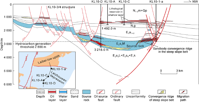
Fig. 7. Hydrocarbon accumulation model in lithologic reservoir formation in shallow layer of KL 10-2 structure in the sandbody convergence steep slope belt. Es—Paleogene Shahejie Formation; Ek—Paleogene Kongdian Formation; Ed— Paleogene Dongying Formation; Nm—Neogene Minghuazhen Formation; Ng—Neogene Guantao Formation; Qp—Quaternary Pingyuan Formation. |
The key elements of this type of hydrocarbon accumulation model include: in the near source of the steep slope zone, the source rocks were directly connected with the sand bodies in which hydrocarbon could be accumulated primarily. The depression controlled fault was vertically connected with sand bodies, and large sized shallow lithological trap was continuously connected with depression controlled faults. In addition, the hydrocarbon migration in shallow layers was severely blocked along the main migration direction (Fig. 7 ). The sand body convergence area in the steep slope belt surrounded the Bozhong Sag is the most potential area for hydrocarbon accumulation in large-scale lithologic reservoirs. The steep slope belt with widely developed boundary fault is the potential area for exploration.
3.2. Hydrocarbon accumulation in the sandbody convergence uplift
The uplift area is the final convergence area for hydrocarbon accumulation, with high accumulation capacity, which is the main reason for the formation of the giant oil fields with more than 1 billion tons of geological reserves[2-3]. The key elements for large-scale hydrocarbon accumulation in lithologic reservoirs are as follows: hydrocarbon accumulated in sandbody convergence uplift, migrated upward vertically through cutting ridge fault, and trapped in the large scale lithologic traps [5]. Mature oil and gas in the Bozhong sag can migrate into the shallow layer by two migration paths, including sandbody convergence ridge in nose structure of steep slope belt and deep oil-source fault (Fig. 8 ). The regional unconformable surface of T8 in the uplift area was directly contacted with the regional transport layer of Guantao Formation, forming favorable reservoirs with strong accumulation capacity. Late fault activities occurred, and the faults were communicated with Guantao Formation, acting as vertical hydrocarbon migration channels, with strong transportation capability. Sand bodies were connected with the ridge-cutting fault, coupling well between sand bodies and ridge-cutting faults, resulting in multi- point hydrocarbon charging. The large-scale high quality reservoirs are good reservoirs for hydrocarbon accumulation, being also favorable transportation layers for lateral oil migration. Due to high efficient lateral hydrocarbon migration through unconformity and sandy conglomerate layer of Guantao Formation, together with the vertical migration along abundant ridge faults, the superimposed oil bearing lithologic traps were finally formed in the shallow reservoirs in the uplift area [1,6,32]. For example, in Shaletian uplift and Shijiutuo uplift, several anticline- type convergence ridges are developed in the buried hill reservoirs. Large-scale lithologic traps in the Lower Member of Minghuazhen Formation are the major exploration targets, such as QHD27-28 and CFD11-3E structures.
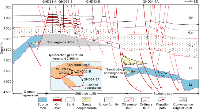
Fig. 8. Hydrocarbon accumulation in the sandbody convergence uplift in lithological reservoirs in QHD 33-1S structure. Es—Paleogene Shahejie Formation; Ek—Paleogene Kongdian Formation; Ed—Paleogene Dongying Formation; Nm— Neogene Minghuazhen Formation; Ng—Neogene Guantao Formation; Qp—Quaternary Pingyuan Formation. |
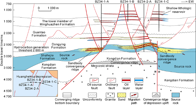
3.3. Hydrocarbon accumulation in uplift within depression area
The hydrocarbon accumulation model in uplift within depression area refers to shallow hydrocarbon accumulation in the medium and small uplifts within depression area (Fig. 9 ). The key elements of this hydrocarbon accumulation model are as follows: hydrocarbon enriched in the uplift within depression area, migrated vertically along a large number of cutting ridge faults, and accumulated in large-scale lithologic traps. Combined with hydrocarbon accumulation characteristics in BZ28-34 Oilfield, the mature oil and gas were enriched and accumulated in deep paleogeomorphologic uplift, in the sand body convergence of the Sha-3 Member of the Shahejie Formation of Paleogene. Due to the unconformable layer, which provided good lateral hydrocarbon migration path and was directly contacted with the deep source, oil and gas could laterally migrate along unconformities or large faults due to the later continuous faulting activity.When oil and gas first arrived at the paleo-uplifted convergence ridge (Paleogene sand body) in the depression area and accumulated, they could not continue to migrate along the unconformity surface of the convergence ridge, and could migrate vertically through a large number of faults which were developed during the late stage and cut through the deep convergence ridge, and accumulated in the lithologic traps connected with faults in the shallow layer.
Fig. 9. Hydrocarbon accumulation in large-scale lithologic traps in BZ28-34 Sag. |
In the sand body convergence area in depression uplifts, the geologic conditions are relatively unfavorable for large scale hydrocarbon accumulation. The key element for large scale hydrocarbon accumulation is the development of a large number of ridge cutting faults, coupling well with late developed sand bodies. The areas with a large number of ridge cutting faults which coupled well with late developed sand bodies are favorable areas for oil and gas exploration in the shallow large-scale lithologic reservoirs, such as BZ 8 structure.
4. Conclusions
The main controlling factors for the hydrocarbon accumulation in the shallow large-scale lithologic reservoirs around the Bozhong area can be summarized as the coupling of four elements: ridge, fault, sand, zone. Ridge refers to deep buried “convergence ridge". The convergence strength of deep convergence ridge controlled the degree of oil and gas enrichment in shallow layers. Faults refer to the faults which cut convergence ridges and were strongly active during the main hydrocarbon accumulation period, being channels for vertical hydrocarbon migration. The activity intensity and the faulted-contact thickness of these faults controlled the vertical hydrocarbon migration capability. Sand refers to a large area of shallow sand bodies that were in contact with the cutting ridge fault in a large area. The scale and shape of sand bodies and their coupling degree with ridge-cutting faults controlled the hydrocarbon charging. The zone refers to the complex fault zone formed by the stress transformation in the main oil and gas migration direction in shallow layers, where the lithological trap has strong sealing effectiveness, and its sealing capability further controlled the hydrocarbon accumulation scale in the lithological reservoir. Among the four elements controlling hydrocarbon accumulation, namely “ridge-fault-sand-zone”, ridge is the main factor controlling hydrocarbon accumulation. Three different types of shallow hydrocarbon accumulation models have been established in the study area, including hydrocarbon accumulation in sand body convergence at the steep slope, hydrocarbon accumulation in the convergence uplift region, and hydrocarbon accumulation in the uplift in depression area. The uplift area, the sand body convergence area at the steep slope and the uplift in depression area are the next hydrocarbon exploration targets in the large-scale shallow lithologic reservoir.