

Introduction
A set of dark mudstone deposits with large thickness and wide distribution are widely developed in the Permian of the Junggar Basin, NW China, mainly distributed in the Permian sedimentary sags such as Mahu, Shawan, Fukang, Jimusar and the periphery of the Bogda Mountain [1-2]. It was confirmed by exploration that it is a set of high-quality source rocks with high hydrocarbon generation and expulsion efficiency. The amount of hydrocarbon generation accounts for more than 60% of the total amount of hydrocarbon generation in six sets of source rocks in the Junggar Basin, which makes it one of the most important source rock layers in the basin. In recent years, breakthroughs have been made in Permian petroleum exploration in the Mahu, Shawan, Fukang and Jimusar sags, including the discovery of the Mahu and Jimusar oil fields at the magnitude of 10×108 t [3⇓-5], and oil and gas breakthroughs or large-scale oil and gas geological reserves have been obtained in the Shawan and Fukang sags [6]. The surrounding area of Bogda Mountain is one of the important potential zones in the junggar Basin for new breakthrough of Permian oil and gas, although the exploration degree is low and no breakthrough has been made due to dark mudstone deposits with large thickness and high-quality of source rock. Scholars have made some studies on the sedimentary strata and tectonic attributes of Bogda tectonic belt during Late Paleozoic, and obtained a series of important understandings on the genetic mechanism of Bogda tectonic belt [7⇓⇓-10], and gradually converged to the view that the tectonic attributes of the Bogda tectonic belt in Late Paleozoic were developed in a rift environment [11⇓-13]. However, the Bogda Mountain tectonic belt belongs to the north Tianshan orogenic belt in the Central Asia orogenic belt, and experienced multi-stage tectonic inversion and strong superimposed deformation and failure after the Late Paleozoic. The division of tectonic units and understanding of stratigraphic filling sequence are not clear, and the history of structural-sedimentary evolution and the nature of prototype basin have been controversial [14]. In particular, the study on basic geological problems such as the development characteristics, sedimentary system types, plane distribution characteristics and evolution law of the lake basin under the Late Paleozoic rift and Middle-Late Triassic extensional environment in the piedmont belt is still relatively insufficient, which restricts the evaluation and in-depth exploration of the oil and gas resources of the surrounding area of Bogda Mountain. Based on the above reasons, the Oil and Gas Survey Center of China Geological Survey carried out continuous basic geological survey research around the region, completed the section survey of eight geological outcrops including Dongdalongkou and Dahuangshan around Bogda, and collected airborne hyperspectral data of 2500 km2 and 2D seismic data of 161 km/11 lines. 2D seismic data of 3200 km have been interpreted, and six wells for geological survey and parameters were drilled. Among them, Well XJC 1 obtained a daily gas production of 1.8×10⁴ m3 in the fracturing test of the Permian Lucaogou Formation for the first time, and obtained a daily gas production of 1.08×10⁴ m3 in the fracturing test of the Triassic Karamay Formation, confirming that the Permian and Triassic of the surrounding area of Bogda Mountain have good oil and gas resource potential. Following the idea that "structure controls the type of basin, basin controls the type of sedimentary facies, and sedimentary facies controls reservoir and cap assemblage", a multidisciplinary comprehensive analysis was carried out to re-divide the tectonic units around the Bogda Mountain, establish a complete stratigraphic sedimentary filling sequence, and focus on the detailed study of the Late Permian and Middle-Late Triassic sedimentary system formed during the structural overturning period. The research results are helpful for deepening the basic geological understanding of the geological structure, lithologic and lithofacies characteristics and sedimentary system evolution law around the Bogda Mountain, so as to provide new ideas and directions for oil and gas exploration in the Bogda complex piedmont structural belt.
1. Geological setting
1.1. Division of tectonic units
The study area includes the main Bogda Mountain, the Fukang fault zone in the north and the Chaiwopu sag in the south, which are related to the tectonic evolution of Bogda Mountain. It is about 400 km long from east to west and 30-50 km wide from north to south, with a total area of about 15 000 km2 [15-17]. According to the analysis of basement properties and relative relief features, stratigraphy and sedimentary formation, tectonic evolution characteristics, genetic mechanism and evolution process, and the division standard of tectonic units of petroliferous basins, the area around Bogda Mountain is divided into Fukang fault zone, Bonan nappe and Chaiwopu sag. There are three secondary tectonic units and six sub-secondary tectonic units in the nappe belt and Chaiwopu sag (Fig. 1 ). The Fukang fault zone can be divided into three sub-secondary tectonic units: Quanzijie syncline, Dahuangshan overburden zone and Miquan anticline. The Chaiwopu sag can be divided into three sub-secondary tectonic units: Dabancheng sub-sag, Yongfeng sub-sag and Sangezhuang sub-salient. Through surface geological survey and fine interpretation of seismic sections, it is revealed that the structural style of the Bogda piedmont zone is mainly "arc thrust", which is characterized by early detachment folds, late thrust structures and reverse faults, which are inclined to the piedmont and thrusted into the basin (Fig. 2 , Table 1 ).
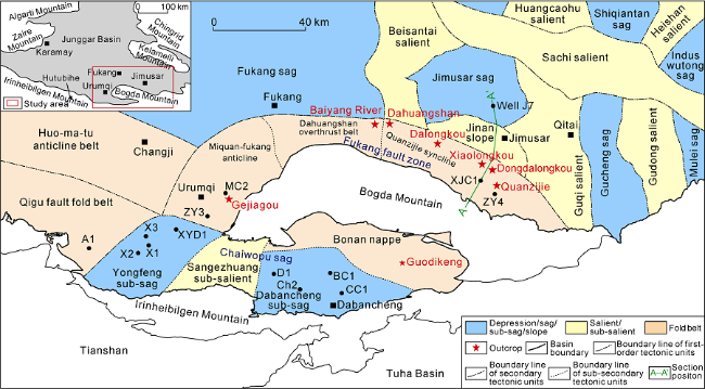
Fig. 1. Division of tectonic units of the surrounding area of Bogda Mountain in Xinjiang. |
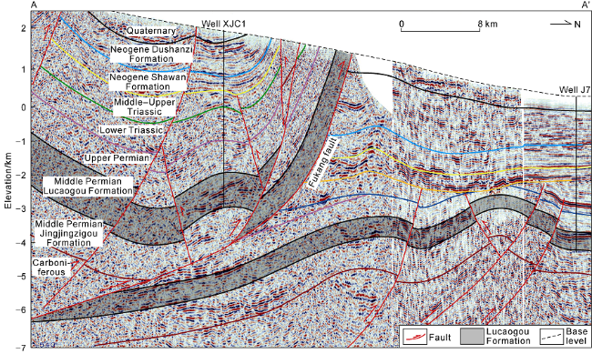
Fig. 2. 2D seismic interpretation section of Well XJC1 spliced with Jimsar sag around Bogda Mountain in Xinjiang (see |
Table 1. Division of structural units around Bogda Mountain in Xinjiang, NW China |
| Secondary tectonic units | Sub-secondary tectonic units | Area/ km2 | Characteristics of the tectonic units |
|---|---|---|---|
| Fukang fault zone | Miquan-Fukang anticline | 1600 | A series of thrust faults are developed from south to north. Together with the upper wall nappe, they form a large-scale thrust nappe structure, mainly imbricated structure and detachment structure, including the Qidaowan anticline, the Gumudi anticline, and the Urumqi syncline. |
| Dahuangshan overthrust belt | 700 | Dominated by fault propagation fold and pop up structures. Compared with the Quanzijie syncline and the Miquan-Fukang anticline, it is narrower from north to south, the exposed strata are more limited, the nappe dip angle is larger, and the stratigraphic trend varies greatly. | |
| Quanzijie syncline | 1700 | It mainly develops the Dalongkou anticline and the Quanzijie syncline. The Quanzijie syncline has relatively complete faults and folds, and weak tectonic deformation. The strata basically spread along the fault strike, representing a unified stress direction of tectonic deformation. | |
| Bonan nappe | 1200 | It is a nappe structural belt formed by the thrusting of the Bogda Mountain toward south. The Permian stratum is exposed, which is the front fold and thrust belt of the Bogda Mountain orogenic belt. The fault in the south margin is dominated by imbricate and detachment structures. | |
| Chaiwopu sag | Yongfeng sub-sag | 1500 | The southern part is bounded by the piedmont basement involved fault at the northern margin of the Yilinhebiergen Mountain, the northern part is bounded by the Bogda Mountain, the eastern part is bounded by the Wulapo fault, and the western part is located in the Mesozoic outcropping area along the Toutun River. Local structures and faults are mainly NE trending, distributed in rows and belts. |
| Sangezhuang sub-salient | 950 | Located in the central part of the Chaiwopu sag, it is northeast-southwest, bounded by large faults on both sides, and mainly composed of Carboniferous bedrocks. Permian, Triassic and Jurassic strata are missing. The top is directly covered by Neogene strata. | |
| Dabancheng sub-sag | 1700 | The southern part is bounded by the piedmont boundary fault of Yilinhebiergen Mountain, the east meets the Bogda Mountain, and the western boundary is the Sangezhuang fault. The overall appearance is like a hedging triangle controlled by a deep detachment fault. |
1.2. Sedimentary filling sequence
Based on the analysis of the lithological characteristics, unconformity surface, drilling data and characteristics of the sedimentary cycle, combined with the previous research results on the geochemistry of magmatic rocks[18⇓-20], the sedimentary filling sequence around the Bogda Mountain was established, and the tectonic evolution stages were divided in details (Fig. 3 ). The stratigraphic filling sequence in the study area is relatively complete. The Carboniferous, Permian, Triassic, Jurassic, Cretaceous, Paleogene, Neogene and Quaternary are developed from bottom to top on the Late Paleozoic fold basement dominated by Devonian magmatic rocks. Affected by the superposition of multiple periods of tectonic movements such as the Hercynian, Indosinian, Yanshanian and Himalayan periods, the tectonic activities in the study area were frequent. A total of seven regional unconformities have been identified, which are between Upper Carboniferous and Lower Permian, Lower Permian and Middle Permian, Middle Permian and Upper Permian, Lower Triassic and Middle Triassic, Upper Triassic and Lower Jurassic, Upper Jurassic and Lower Cretaceous, Oligocene and Miocene, respectively, from old to new. There are also four local unconformities. The evolution of the surrounding area of the Bogda Mountain can be divided into 9 stages, namely Late Carboniferous residual ocean-continental margin rift basin transition stage, Early Permian continental margin rift basin stage, Middle Permian intracontinental rift basin stage, Late Permian foreland basin stage, Triassic intracontinental depression stage, Early-Middle Jurassic extensional fault basin stage, Late Jurassic compressive-torsion basin stage, Cretaceous intracontinental unified depression stage and Cenozoic regeneration foreland basin stage [21]. The Middle Permian intracontinental rift basin stage is the main development stage of the high-quality source rocks of the Permian Lucaogou Formation. The Triassic intracontinental depression stage is the main development stage of the reservoir of the Middle and Upper Triassic Karamay Formation. The Cretaceous intracontinental unified stage and the Cenozoic regenerated foreland basin stage are the main formation stages of thrust structures and traps, which play an important role in late migration and accumulation of oil and gas
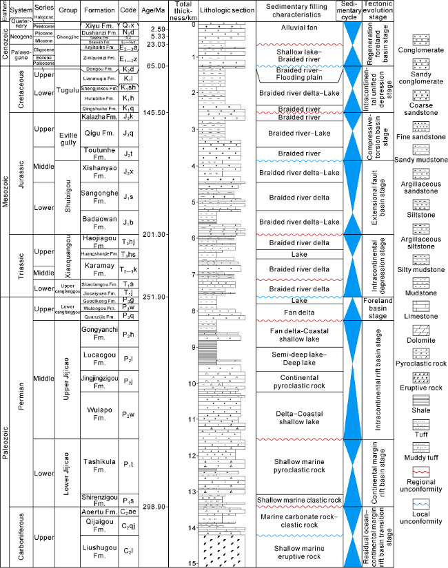
Fig. 3. Sedimentary filling sequence and tectonic evolution stages of the surrounding area of Bogda Mountain in Xinjiang. |
2. Sedimentary characteristics and types of the Middle-Upper Permian and Middle-Upper Triassic
Through field outcrop section observation (Fig. 4 ), core description and sample analysis and testing, three main types of sedimentary facies were identified around the Bogda Mountain in the Middle and Upper Permian and Middle and Upper Triassic, including lake, fan delta and braided river delta with quite different lithology, lithofacies combination, sedimentary structures, lithoelectric responses and sedimentary cycles.
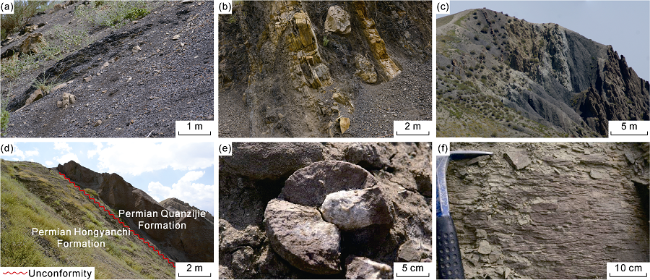
Fig. 4. Field geological section characteristics of the Middle-Upper Permian and Middle-Upper Triassic in the surrounding area of Bogda Mountain in Xinjiang. (a) Black shale, upper Lucaogou Formation, east Dalongkou section. (b) Black shale intercalated with dolomite, Lucaogou Formation, east Dalongkou section. (c) Black oil shale with thin sandstone, Lucaogou Formation, east Dalongkou section. (d) Angular unconformity between Hongyanchi Formation and Quanzijie Formation, Dalongkou section. (e) Calcareous sand ball of Triassic Jiucaiyuanzi Formation, Dahuangshan section. (f) Medium and small corrugated cross-bedding, Triassic Huangshanjie Formation sandstone, Dahuangshan section. |
2.1. Lake
The lake facies include semi-deep lake-deep lake and coastal shallow lake sub-facies. The semi-deep to deep lake subfacies is mainly developed in the Middle Permian, and dominated by vertical deposition of suspended matter in deep water, with local deposits carried by rapid gravity flow. Its rock type is dominated by mud shale (Fig. 5 a), with a small amount of silty mudstone (Fig. 5 b, 5c), argillaceous siltstone (Fig. 5 d), micrite dolomite (Fig. 5 e) and a small amount of lithic sandstone (Fig. 5 f). The shale has a laminar structure which makes it easy to peel off along the bedding plane. Affected by sources and seasonal climate fluctuations, algae and other organic matters, carbonate, clay, silty feldspar, quartz and volcanic ash form continuous laminae [20].
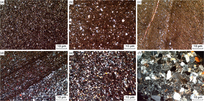
Fig. 5. Microscopic characteristics of the rocks in the Permian Lucaogou Formation in Well XJC1 around Bogda Mountain in Xinjiang. (a) Mud shale, 4068.0 m. (b) Silty mudstone, 4238.4 m. (c) Silty mudstone with fine cracks filled with lime cements, 4199.2 m. (d) Argillaceous siltstone, 4080.2 m. (e) Micrite dolomite, 4160.0 m. (f) Medium-grained lithic sandstone, 3689.2 m. |
Dolomite interlayers are mainly distributed in the black shale in the upper member of the Lucaogou Formation, generally less than 0.5 m thick. Both the dolomite and the black shale have horizontal bedding and fine wave bedding, generally 0.5-1.0 mm thick. Under the microscope, the dolomite and a small amount of terrigenous clastic aggregates constitute directional structures, indicating that they were formed in a low-energy environment. A large number of authigenic minerals such as pyrite are developed (Fig. 6 a), which are filled in rock fractures or occur in a lenticular shape along beddings, representing a water-stagnant alkaline reducing environment. Under the microscope, well-preserved ostracods, bivalves, fossils such as fish and plants can be seen (Fig. 6 b). This set of lithological sequence is stable in lateral distribution and the sedimentary thickness is large, indicating that the Bogda Mountain area in the Middle Permian was a deep-water lake basin with the deposition center consistent with the subsidence center, and it was the product of the largest lake flooding event in the Late Paleozoic [22-23]. Sausage-like liquefied sandstone veins (Fig. 6 c) and graded bedding (Fig. 6 d) are developed in the black shale of the Lucaogou Formation in Well XJC1, which are accompanied by a large number of deformed structures of soft sediments, including fluidized structures, mixed-slip structures, small synsedimentary fault structures and enveloping bedding (Fig. 6 e). They are turbidite sand bodies resulting from fan delta front sand bodies that moved forward under the action of their own gravity or the influences of various inducing factors such as earthquakes and fault activities, and then got liquefied into turbidite current toward the deep lake basin, and finally deposited in the semi-deep to deep lake area. This indicates that rapid sedimentation of gravity flow has occurred in the local area of the lake basin. The semi-deep to deep lake subfacies is generally dominated by a large set of gray-black shale, in which turbidite sand is sandwiched and developed with slump structure. The coastal shallow lake subfacies is mainly developed in the Upper Permian and Middle-Upper Triassic around the Bogda Mountain The rock types are mainly light gray, gray-green claystone and siltstone, in a weakly oxidizing to weakly reducing environment. With sufficient supply of terrigenous clasts, rich fine sandstone appears with argillaceous and calcareous cements and good sorting and roundness. Dominated by horizontal and wavy beddings, shallow lake areas with strong hydrodynamic intensity have small cross bedding. When sand-mudstone is deposited alternately, lenticular bedding can be formed.
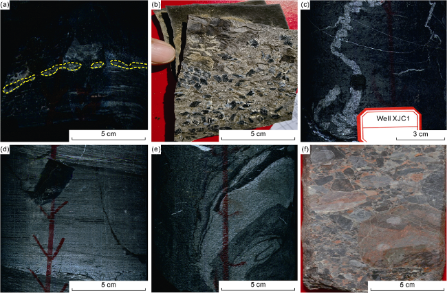
Fig. 6. Lithology, fossils and sedimentary structures in the Lucaogou Formation around Bogda Mountain, Xinjiang. (a) Pyrite developed along beddings, 4238.0 m, Well XJC1. (b) Fish scale fossils in Lucaogou Formation, Dahuangshan section. (c) Sausage-shaped liquefied sandstone vein, 3814.0 m, Well XJC1. (d) Graded bedding, 4563.0 m, Well XJC1. (e) Enveloping bedding, 4563.0 m, Well XJC1. (f) Conglomerate deposits in fan delta plain, 3031.5 m, Well C1. |
2.2. Fan delta
Fan delta mainly developed in the Middle and Upper Permian, is distributed in Chaiwopu sag on the southern margin of Bogda Mountain, and can be divided into fan delta plain, fan delta front and pre-fan delta subfacies.
The subfacies of fan delta plain is dominated by thick conglomerate and conglomerate sandstone, with low maturity and poor-medium sorting. Among them, the sediments in the distributary channels have positive rhythmic beddings with grains coarse in the lower part and finer in the upper part. The coarsest gravel is often distributed in the middle of the channel with poor sorting. The gravel is sub-angular to sub-round (Fig. 6 f). The sedimentary sequence shows that conglomerate with scour structure is at the bottom, and upward there are 2 to 4 sets of sandy conglomerate debris flow or sheet flow deposits with a positive grain sequence, with large-scale cross-beddings and layered cross-beddings.
The fan delta front subfacies is mainly gravel-bearing sandstone and medium-coarse sandstone, with finer lithology than the fan delta plain subfacies, and develops large and medium cross-beddings and other tractive flow sedimentary structures [24]. The fan delta front subfacies can be subdivided into underwater distributary channel, underwater distributary inter-channel sediment, estuarine sand bar and front sheet sand. In the fan delta, the underwater distributary channel is composed of gravel-bearing sandstone and sandstone, which are moderately sorted and often come into abrupt contact with the mudstone at the bottom. The underwater distributary interchannel deposits consist of interbedded light grey siltstone and grey-green mudstone. During the Middle-Late Permian, the terrain in the southern margin of the Bogda Mountain was different in elevation, with strong tectonic activities, steep basin slopes, and sufficient supply, which are conducive to the development of fan deltas.
The pre-fan delta subfacies is located in the deeper water area below the wave base. It is narrowly distributed, and transitions to the mudstone of semi-deep to deep lake subfacies. There is no obvious lithological boundary between them.
2.3. Braided river delta
The braided river delta facies is mainly developed in the Middle-Upper Permian in the Kelameili piedmont and the Middle-Upper Triassic Karamay Formation of the surrounding area of Bogda Mountain. The coarse-grained delta entered coastal shallow lake area from piedmont alluvial plain, whose development is mainly affected by braided rivers, can be divided into braided river delta plains, braided river delta fronts and pre-braided river deltas. Among them, the underwater distributary channel is the main body of the braided river delta front. Its sedimentary characteristics are similar to the braided channel sand body. Its internal structure is composed of many sandstone lens with coarse lower and thin upper ones superimposed with each other. Single lenticular body, generally 0.6-5.0 m thick, is usually fine conglomerate, conglomerate-bearing medium to coarse sandstone and medium-grained sandstone from the bottom to the top. Due to the frequent migration of channels, the lateral accretion cross-beds are extremely developed in the sand body.
In addition, scour surface structures, parallel beddings and large- and medium-sized cross-beddings are common. Changes in lithology, structure and vertical sedimentary sequence are important for identifying the braided river sedimentary facies [25-26]. The vertical sedimentary sequence of braided river sand bodies in the study area is mainly composed of single-channel sand bodies spliced and superimposed to plate-shaped composite channel sand bodies. With greatly varied thickness, the channel sand bodies are well connected, which is the main sedimentary facies type for the formation of Triassic oil and gas reservoirs around the Bogda Mountain. The mouth bar facies is located at the end and side edge of the underwater distributary channel. The lithology is medium- and fine-grained sandstone, and local gravel-bearing sandstone. It shows an inverse rhythm from fine to coarse from bottom to top. Affected by strong hydrodynamic activities, the mouth bar has low mud content. Parallel bedding and medium cross-bedding can be seen.
The well-connected sedimentary facies section from south to north around the Bogda Mountain shows that the Lucaogou Formation in Well D1 located in the Chaiwopu sag on the south side of the Bogda Mountain is a thick glutenite layer of fan delta plain subfacies. The Lucaogou Formation in Well CC1 is mainly interbeds of glutenite and purple-grey green mudstone of fan delta plain subfacies. The third member of the Lucaogou Formation on the Guodikeng section is mainly composed of gravel-bearing sandstone, sandstone and mudstone interbeds which show the characteristics of distributary channels of fan delta front subfacies. The second member is mainly composed of gray and gray-black mudstone with a small amount of sandstone, showing the characteristics of interactive deposition of pre-fan delta and lacustrine mudstone. The first member transitions to a set of dark shale deposits of deep lacustrine subfacies. Well XJC1 located on the north side of the Bogda Mountain has lower glutenite content, and is mainly composed of deep lacustrine dark mudstone with a small amount of turbidite sand bodies. The Lucaogou Formation in Well XJC1 is the thickest. The Lucaogou Formation in Well J174 in the north is also dominated by dark shale, but its thickness is greatly reduced. On the whole, the Lucaogou Formation in the southern Bogda Mountain is dominated by fan delta deposits in the lateral direction, and progressively progrades to the north, and finally transitions to semi-deep to deep lake subfacies. Vertically, the fan delta in the Lucaogou Formation shows a retrograding sedimentary sequence. The lake flooding range gradually increases from bottom to top, until to the largest lake flooding surface in the upper part of the Lucaogou Formation (Fig. 7 ).
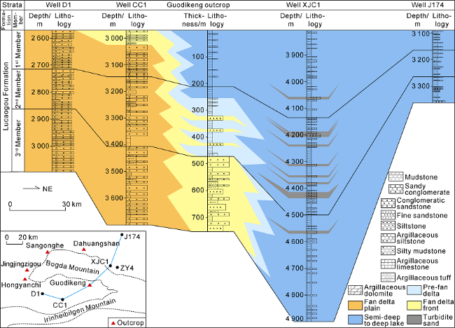
Fig. 7. The sedimentary facies section of Lucaogou Formation across Well D1-Well CC1-Guodikeng outcrop-Well XJC1-Well J172 around Bogda Mountain. |
3. Distribution of sedimentary facies
Based on the comprehensive data analysis of outcrop, single-well, seismic data, and connected well profile, single- factor contour maps such as formation thickness, conglomerate thickness, sandstone thickness, sand-to-formation ratio, and carbonate mineral content were drawn. The method of single-factor analysis and multi-factor mapping is used to compile the plane distribution map of the sedimentary system of key intervals, and to clarify the distribution law of the sedimentary system from the Middle-Upper Permian to the Middle-Upper Triassic. Among them, the three intervals, namely the Middle- Upper Permian Lucaogou Formation, the Middle-Upper Permian Quanzijie Formation, and the Middle-Upper Triassic Karamay Formation, are representative of the plane distribution characteristics and evolution laws of sedimentary facies, and they are important source rocks and reservoirs with great oil and gas geological significance in the study area.
3.1. Distribution of sedimentary facies of the Middle Permian Lucaogou Formation
During the depositional period of the Middle Permian Lucaogou Formation, the surrounding area of Bogda Mountain was in the evolutionary stage of the intracontinental rift basin, and the whole was in a tectonic extensional environment. The analysis of tectonic evolution, formation thickness change and sedimentary characteristics show that the study area was a unified lake basin in this period, and the present Bogda Mountain and its northern margin are the subsidence center and deposition center of the Middle Permian Lucaogou Formation during the depositional period, and the faults on the boundary of the rift basin control the extension direction and tectonic shape of the lake basin. The lake basin extends axially in a nearly east-west direction, and is steep in the south and gentle in the north. The southern part is dominated by fan delta deposition, the central part is dominated by semi-deep to deep lake and gravity flow deposition, and the northern part is dominated by coastal shallow lake and braided river delta deposition.
In the southern part, the provenance area is dominated by northern Tianshan Mountain and Yilin Heibergen Mountain. The terrain slope is large, and the alluvial fans quickly enter the lake basin to the north, forming fan delta deposits in Chaiwopu area of the steep slope belt of the lake basin. Among them, the fan delta plain is mainly distributed in Dabancheng, Guodikeng, wells C3, CC1, D1, and the front edge of the fan delta is mainly distributed in Well BC1 and other areas. Due to the rapid deepening of the water body, the pre-fan delta and coastal shallow lake have the smallest distribution area, and are mainly distributed in the wells X2, X3 and XYD1. The central area is the sedimentation and subsidence center of the lake basin, with the largest distribution area, and mainly developed semi-deep to deep lake sedimentary facies, mainly distributed in the present Bogda Mountain and the northern margin of Dongdalongkou, Dahuangshan, Fukang, Changji and Well D1. In areas such as wells ZY4 and XJC1, no coarse-grained basin edge facies were found in the field geological survey and drilling, and the lithology was mainly thick layers with fine-grained sediments, such as black shale, oil shale and dolomite shale. In the deep low-lying areas of the lake basin, such as Well XJC1, Dalongkou, Baiyang River and Sangong River, a small amount of gravity flow deposits developed, mainly distributed along the axis of the lake basin in a nearly east-west direction. In the area to the north of wells F5 and J15, the sedimentary facies transitioned from semi-deep-deep lake subfacies to coastal shallow lake subfacies. In the northern Kelameili Mountain area, the terrain slope is gentle, and braided river delta deposits are mainly developed, which prograde from north to south, with a large scale and a long extension distance. Among them, the braided river delta plains are distributed in wells D3, SS2, D8 and SD1, the fronts of braided river deltas are distributed in areas such as wells C25 and C26, and the pre-braided river deltas are distributed in wells SQ1 and B17 and other areas (Fig. 8 ).
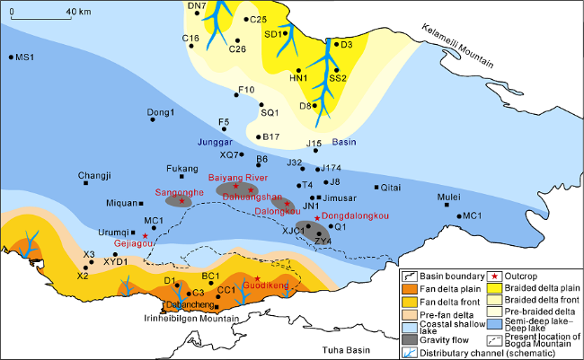
Fig. 8. Distribution of sedimentary facies of the Lucaogou Formation around the Bogda Mountain, Xinjiang. |
The sedimentary period of the Middle Permian Lucaogou Formation was one of the important lake flooding periods in the southeastern Junggar Basin [21,27]. The semi-deep to deep lake areas such as Bogda Mountain and Well XJC1, Dongdalongkou, Dahuangshan, Fukang, Changji and Well D1 in the northern margin are main development areas for high-quality source rocks of the Middle Permian Lucaogou lacustrine facies in the study area and also a favorable target area for finding shale oil and gas. The drilled thickness of the Lucaogou Formation in Well XJC1 is 1140 m, and the thickness of the high- quality source rock is over 400 m. The gas was measured in the 4153.5-4229.0 m section of the Lucaogou Formation, with a total of 18 m/6 sections for production and a daily gas production of 1.8×10⁴ m3 and a daily production of condensate oil of 0.41 t, which proves that this area has good exploration potential of shale gas resources.
3.2. Distribution of sedimentary facies of the Upper Permian Quanzijie Formation
During the depositional period of the Upper Permian Quanzijie Formation, the Bogda Mountain area has undergone significant changes, from an intracontinental rift basin to a foreland basin evolution stage. The basement is uplifted with a low relief and a low salient is formed in the Bogda Mountain area, which divides the periphery of the Bogda Mountain into two areas, the north and the south. The west of the low salient is connected with the main body of the lake basin. During this period, the water depth of the lake basin became shallow as a whole, and the sedimentary type was dominated by the coastal shallow lake subfacies. In addition to the two major provenance areas of the northern Tianshan Mountain and the Yilin Heibergen Mountain in the south, and the Kelamei Mountain in the north, the Bogda low salient has also become an important provenance supply area. The discovery of oil shale gravel in the Quanzijie Formation mudstone sediments on Dalongkou section also indicates that the sediments of the Lucaogou Formation in the Bogda low salient began to be weathered and fragmented and formed new provenances during this period, and developed a series of fan delta sedimentary bodies along the periphery of the Bogda low salient.
The Chaiwopu area in the south is in a semi-enclosed lake bay environment, the provenance area is dominated by the northern Tianshan Mountain, Yilin Heibergen Mountain and Bogda low salient, and mainly develops fan delta facies and coastal shallow lake subfacies. The fan delta is small in scale and mainly distributed around the Bogda low salient on the north side of the lake bay and the northern Tianshan Mountain and Yilin Heibergen piedmont in the south. Fan delta plain subfacies are mainly distributed in Dabancheng, wells CC1 and XYD1 and other areas, and wells C3, X2, X3 and other areas gradually transition to fan delta front subfacies. The pre-fan delta is mainly distributed in wells BC1 and D1 and other areas, the Guodikeng area is the coastal shallow lake sub-facies. The northern part of the Bogda low salient has a wide range of lake basin and a large distribution area of fan delta, extends towards north with the largest distance to well area 17 in Jimusar. The fan delta plain subfacies are mainly distributed in Dahuangshan, wells XJC1, ZY4, MC1 and XYD1, etc. The fan delta plain is mainly distributed in Qitai, Fukang, Miquan, wells JN1, T4, J32 and other areas. Small-scale braided river deltas developed in wells DN7 and C16 of the Kelameili piedmont in the north, which prograded from north to south, with a small distribution area and a short extension distance (Fig. 9 ).
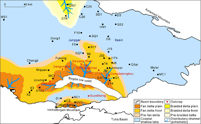
Fig. 9. Sedimentary facies distribution of the Quanzijie Formation around Bogda Mountain, Xinjiang. |
Reservoir sand bodies such as underwater distributary channels and estuarine sand bars are developed in the front subfacies of the fan delta of the Quanzijie Formation around Bogda Mountain, but they are closer to the provenance area and have higher shale content, easy to form tight oil and gas reservoirs.
3.3. Distribution of sedimentary facies of the Middle and Upper Triassic Karamay Formation
At the beginning of the Triassic period, controlled by the tectonic background of the overall extension of the Junggar Basin, the surrounding area of Bogda Mountain entered the evolutionary stage of intracontinental depression basin from the separated foreland basin system. During the depositional period of the Karamay Formation in the Middle and Upper Triassic, the surrounding topography generally decreased, and the Bogda low salient formed in the Late Permian subsided into the water. The types of sedimentary facies are mainly braided river delta facies and coastal shallow lake subfacies distributed widely. Controlled by provenance and paleogeomorphology, the study area can be divided into two major sedimentary systems, north and south.
In the southern part, the provenance area is dominated by the North Tianshan and Yilin Heibiergen mountains with relatively sufficient supply, and four braided river delta composite sedimentary bodies develop sequentially from east to west. Among them, the three braided river delta composite sedimentary bodies in Well ZY4, Guodikeng and Urumqi are relatively large in scale, and progressively prograde from south to north, extending for a distance of 40-100 km. The braided river delta plain is lobed, mainly distributed in the areas of Guodikeng, Dabancheng, wells CC1, BC1 and D1. The front edge has the largest distribution area, which is mainly distributed in the present Bogda Mountain, wells Q1 and XJC1, Dahuang Mountain, Baiyang River, Sangong River, Miquan and Urumqi. In the northern region, the provenance area is dominated by the Kelameili Mountain, and a composite sedimentary fan body is developed, which is distributed in the areas of wells D3, SS2 and D8, and prograde from north to south. Due to the lack of provenance in this area, the braided river delta is smaller in scale and shorter in extension than that in the Bogda Mountain. The Qitai, Mulei, Jimsar, wells J32, F10 and D1 in the central part are sub-facies of coastal shallow lake sediments with a large distribution area (Fig. 10 ).
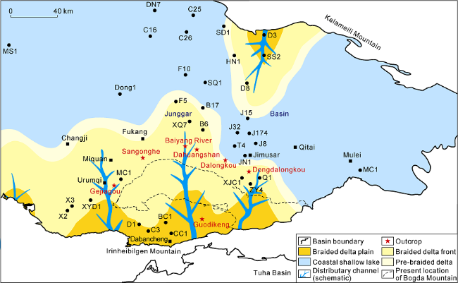
Fig. 10. Sedimentary facies distribution of the Karamay Formation around Bogda Mountain, Xinjiang. |
The widely distributed braided river delta front of the Triassic Karamay Formation has a large number of sedimentary sand bodies such as underwater distributary channels and mouth bars, which are easy to form lithologic and lithologic-structural oil and gas reservoirs. It is the main exploration type of shallow Triassic oil and gas reservoirs around the Bogda Mountain. In the Karamay Formation, Well XJC1 encountered a total of 11.6 m/1 layer of gas-water layer, and 6 m/1 layer of gas-bearing water layer. The 1385.5-1392.0 m well section of the Karamay Formation was tested for gas production, with a daily gas production of 1.07×10⁴ m3. Shallow gas reservoirs in the Triassic Karamay Formation were discovered in the Bogda piedmont for the first time, confirming that the shallow Triassic Karamay Formation in this area has good natural gas exploration potential.
4. Depositional model and tectonic depositional environment
4.1. Middle-Late Permian and Middle-Late Triassic depositional models
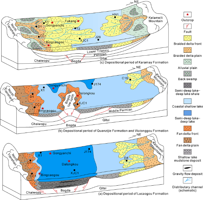
Based on the law of facies sequence gradient, and combined with the development characteristics of present sedimentary facies, the spatial combination form and evolution law of the Middle-Upper Permian and Middle-Upper Triassic sedimentary facies around the Bogda Mountain were defined (Fig. 11 ).
Fig. 11. Depositional model of the Middle-Upper Permian-Middle-Upper Triassic around Bogda Mountain in Xinjiang. |
During the depositional period of the Middle Permian Lucaogou Formation, the periphery of the Bogda Mountain was in a continental intracontinental rift environment. Together with the Jiangjunmiao area and the piedmont of Kelameili Mountain, an asymmetric unified lake basin with faults in the south and superposition in the north was formed. Water was the deepest in the Bogda Mountain area in the south, which was in a deep lake sedimentary environment, while it was shallow in Jiangjunmiao area to the piedmont of the Kelameili Mountain, which was in coastal shallow lake sedimentary environment. A sedimentary system with fan delta and semi-deep to deep lake developed in the south, while the one in the north was with braided river delta and shallow lake (Fig. 11 a).
During the depositional period of the Quanzijie Formation and Wutonggou Formation of the Upper Permian, the Bogda Mountain area underwent a tectonic inversion and was uplifted as a whole. It evolved from a rift to a low salient with shallow water. A fan delta and shore- shallow lake sedimentary system deposited in the Chaiwopu area in the south, a series of fan delta fans developed on the north and south sides of the Bogda low salient, and a braided river delta and coastal shallow lake sedimentary system developed in the north (Fig. 11 b).
During the depositional period of the Middle and Upper Triassic Karamay Formation, the Bogda area was in an extensional environment. The Bogda low salient subsided into water and no longer provided sources. A unified shallow lake basin was formed once again in the Bogda Mountain area, the northern Jiangjunmiao and the Kelameili Mountain piedmont. As a result, two major braided river delta sedimentary systems are developed with northward and southward progradation. Among them, the northern Tianshan Mountain and Yilinheibergen Mountain in the south provided sufficient sources, so the sedimentary system is the largest (Fig. 11 c).
4.2. Controlling effect of tectonic inversion on sedimentary system
Tectonic movement is a decisive factor controlling the evolution of the sedimentary system of the surrounding area of Bogda Mountain, which influences the type and evolution of the sedimentary system by controlling the shape, type, subsidence rate and accommodation space of the basin [28⇓⇓-31]. In recent years, scholars have done many studies on the Bogda structural belt and its Late Paleozoic structure, such as the petrophysical, petrochemical and isotopic geochemical characteristics analysis of magmatic rocks [32⇓-34]. Finally they concluded that the periphery of the Bogda Mountain of the Late Carboniferous-Early Permian was in a rift environment [35]. The tectonic setting of the intracontinental rift continued to the Middle Permian, making the Bogda area a subsidence center, which provided large accommodation space for sediments accumulation. The huge height difference between the Bogda Mountain and the northern Tianshan Mountain in the south resulted in narrow and steep paleo-geomorphic features, and consequently alluvial fan sediments from south quickly entered the lake without long-distance transportation and formed a fan delta- semi-deep lake-deep lake deposition system. In the Late Permian, the Bogda Mountain area began to uplift at a low relief, and the Hongyanchi Formation and even the Lucaogou Formation suffered extensive denudation locally, resulting in an angular unconformity between the Middle Permian and the Upper Permian Quanzijie Formation. The sediments of the Upper Permian Quanzijie Formation contain a large amount of oil shale gravels from the Lucaogou Formation, indicating that the Bogda Mountain area has been uplifted and began to provide sources. The angular unconformity of the Middle-Upper Triassic Karamay Formation overlying the Shaofangou Formation of the Lower Triassic gradually transitioned into a parallel unconformity-conformity in the Badaowan area of Urumqi, indicating that the Indosinian orogeny had carried out the transformation on it. Weak extension occurred in the lake basin during Middle-Late Triassic, resulting in the formation of low-amplitude and gentle paleogeomorphology from the periphery of Bogda Mountain to Jimusar, which is favorable for the development of braided river delta deposits in this area.
5. Conclusions
The northern and southern depression areas around the Bogda Mountain are divided into 3 secondary tectonic units and 6 sub-secondary tectonic units. The basin tectonic evolution was subdivided into 9 stages.
In the Middle-Late Permian to the Middle-Late Triassic, three types of sedimentary facies developed, including lake, fan delta and braided river delta. In the Middle Permian, the present Bogda Mountain area was the subsidence center and deposition center of the deep-water lake basin. In the Late Permian, the Bogda Mountain area uplifted to form a low salient and provided provenance. Then in the Middle-Late Triassic, the low salient subsided into water and formed a large scale of braided river delta deposits.
Tectonic movement was the decisive factor controlling the evolution of the sedimentary system around the Bogda Mountain. Early intracontinental rifting Late Permian tectonic uplift with a low relief, and Middle-Late Triassic tectonic subsidence controlled the shape, type, subsidence rate and accommodation space, further influencing the type and evolution of sedimentary system.