

Introduction
Archaeozoic metamorphic buried hills are important focuses for deep oil and gas exploration in the Bohai Bay Basin, East China [1⇓-3]. Large oil fields, such as Jinzhou 25-1 South and Penglai 9-1, were discovered in Archaeozoic metamorphic buried hills in 2007 and 2012, respectively[4]. Bozhong 19-6 condensate gas field in the Archaeozoic metamorphic buried hill, discovered in 2019, marks another large gas field on the scale of 100 billion cubic meters in the Bohai Bay Basin and opens a new avenue for gas exploration of buried hills in the oil-rich Bohai Bay Basin[3]. In 2021, another hundred million tons oil and gas field of Archaeozoic metamorphic buried hill, Bozhong 13-2, was discovered in the structure near Bozhong 19-6, which further shows the broad exploration prospects of deep Archaeozoic metamorphic buried hills in the Bohai Bay Basin [1,5]. However, some Archaeozoic buried hills, such as the Qinhuangdao 428 buried hill, have not led to industrial oil and gas discovery [1,5]. Studies have shown that reservoir conditions are the key to determining whether the Archaeozoic metamorphic buried hills can form large reservoirs in the Bozhong Sag [6].
Metamorphic rocks are tight and do not have primary pores [7⇓-9]. Studies on typical bedrock buried hill oil and gas fields show that reservoirs of metamorphic buried hill are formed by later modifications such as weathering and leaching, tectonic fracturing and hydrothermal dissolution, and tectonic fractures and dissolution pores are main reservoir spaces [7⇓-9]. Description of the distribution of these dissolution pores and fractures in buried hills is the basis for exploring the formation conditions and de-velopment rules of favorable reservoirs in metamorphic buried hills in the offshore oil area of the Bohai Bay Basin. Xu et al. [3] classified the vertical reservoir units of the Bozhong 19-6 metamorphic buried hill. The weathering crust was divided into clay zone, weathered glutenite zone and weathered fracture zone, and the inner buried hill was divided into inner fracture zone, tight zone, and bedrock zone to illustrate the reservoir space types and physical characteristics of different reservoir zones. However, the lack of corresponding geological and logging identification criteria for these reservoir units results in a lack of consistency of lateral reservoir correlation between wells and restricts fine depiction of reservoirs in the Archaeozoic metamorphic buried hills and a deep understanding of the spatial distribution of the reservoirs. In addition, according to whether the direct overlying strata include Cenozoic, the Archaeozoic buried hills can be divided into two types: exposed buried hills (EBH) and covered buried hills (CBH) [1,5]. An EBH refers to an Archaeozoic buried hill that is in direct contact with Cenozoic sedimentary strata, while a CBH refers to an Archaeozoic metamorphic buried hill that is covered by tight pre-Cenozoic such as Mesozoic or Paleozoic and does not directly contact the sedimentary strata of the Cenozoic. Exploration has indicated that both types of buried hills can form large oil and gas reservoirs, but there are some differences in their efficiency for reservoir formation [1⇓⇓⇓-5,10]. It is necessary to compare and analyze the similarities and differences in the vertical reservoir characteristics of these two types of buried hills to provide a geological basis for further exploring the main controlling factors of high-quality reservoirs in different types of buried hills.
This study focuses on Archaeozoic metamorphic buried hills, such as Bozhong 19-6 (EBH), Bozhong 13-2 and Qinhuangdao 428 (CBH), in the Bozhong Sag, Bohai Bay Basin. By making full use of cores, thin cast sections, physical reservoir property data, conventional logging data and formation microscanner image (FMI) logging data of 27 wells in the study area drilling into the Archaeozoic metamorphic buried hills, the vertical characteristics of the structures, pores and fractures in the buried hills are described in details, and a classification scheme of the reservoir units of Archaeozoic metamorphic buried hills is established in the study area. In addition, the geological characteristics of different reservoir units are described, and identification markers for conventional logging and FMI logging are established. On this basis, favorable reservoir belts in the two types of buried hills are discussed. This study is expected to provide a geological basis for fine reservoir description and deep study of a favorable reservoir distribution rule in Archaeozoic metamorphic buried hills.
1. Geological setting
The Bohai Bay Basin is located in the eastern North China Craton, covering an area of 20×104 km2 and it is a typical Meso-Cenozoic intracontinental rift basin. In the basin, the offshore oil area is 4.4×10⁴ km2, which is mainly composed of the Bozhong Sag, Qinnan Sag, Liaozhong Sag, Shaletian uplift, Bonan Low uplift, Qinnan uplift and other secondary structural units (Fig. 1 a). The Bozhong Sag is the largest hydrocarbon-rich sag in the Bohai Bay Basin, and its basement is composed of multiple sets of strata, including Archaeozoic, Lower Paleozoic, Upper Paleozoic and Mesozoic strata (Fig. 1 b)[11]. The Archaeozoic buried hill has complex lithology, including migmatitic granite, migmatitic gneiss, gneiss, TTG (trondhjemite, tonalite, granodiorite series) and others [3]. The Bozhong Sag experienced a complex tectonic evolution process: Before the Indochinese period, the basement was dominated by vertical ascending and descending movement, and a Paleozoic interval with stable thickness was deposited. Influenced by the Caledonian movement, the Upper Ordovician-Lower Carboniferous were absent (Fig. 1 b) [12-13]. During the early Indosinian (Early Triassic-early Late Triassic), influenced by the collision between the Yangtze plate and the North China craton, the area around the Bozhong sag was in a near north-south compressive stress field, resulting in a series of NWW thrust faults, such as boundary faults of Shaletian uplift, Bonan low uplift and Chengbei uplift. Thrusting and folding led to a NWW-trending uplift and depression pattern, forming the Archaeozoic buried hills in the study area [13] (Fig. 1 a).
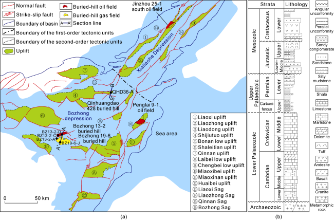
Fig. 1. Structural outline map and comprehensive stratigraphic column diagram of buried hills in the Bohai Bay Basin. (a) Structural outline map and distribution of Archaeozoic metamorphic buried hill oil and gas fields in the Bohai Sea; (b) Comprehensive stratigraphic column diagram of the Bozhong Sag. |
Bozhong 19-6 and Bozhong 13-2 buried hills selected in this study are anticlinal tectonic zones located between the Shaletian uplift and Bonan low uplift in the south of the Bozhong Sag [3]. Qinhuangdao 428 buried hill is located at the southeast end of the Shijiutuo uplift in the north of the Bozhong Sag [12] (Fig. 1 a). In the early Indosinian Period, a high-dip thrust fault was developed on the northern boundary of Bozhong 19-6 and Bozhong 13-2 buried hills (Fig. 1 a). As a result, the Archaeozoic basement broke out and uplifted into hills, and the Paleozoic was completely denuded at the top of the Bozhong 19-6 and Bozhong 13-2 buried hills [13-14]. As shown in Fig. 2 a, Bozhong 19-6 and Bozhong 13-2 buried hills are completely uncovered by Paleozoic rocks. In the same period, the Archaeozoic basement of the Qinhuangdao 428 buried hill did not break out, therefore only a series of compressional fold structures were formed, and the Paleozoic was preserved at the top of the Qinhuangdao 428 buried hill due to weak denudation [12] (Fig. 2 b). Influenced by the regional extensional background, a series of faulted basins were formed in the middle Yanshan Period (Late Jurassic to Early Cretaceous). As a result, Mesozoic strata were deposited in Bozhong 13-2 buried hill and Qinhuangdao 428 buried hill. In Fig. 2 a, Mesozoic strata exist at the top of Bozhong 13-2 buried hill and on the fault hanging walls on the north and south sides of Qinhuangdao 428 buried hill in Fig. 2 b. In the late Yanshan Period (Late Cretaceous), strong regional extrusion events occurred again in this area, and Bozhong 19-6 buried hill was uplifted again and subjected to denudation, forming an EBH [3,13] (Fig. 2 a). The overlying Mesozoic strata of Bozhong 13-2 buried hill were denuded and thinned at the side close to Bozhong 19-6 but not completely denuded. The Mesozoic strata at the top of Bozhong 13-2 buried hill were preserved [1,5,13] and formed the CBH, which is covered by Mesozoic strata (Fig. 2 a). The Mesozoic strata at the top of Qinhuangdao 428 buried hill have been denuded completely, but the Paleozoic strata were still preserved [12], forming the CBH, which is covered by Paleozoic strata (Fig. 2 b).
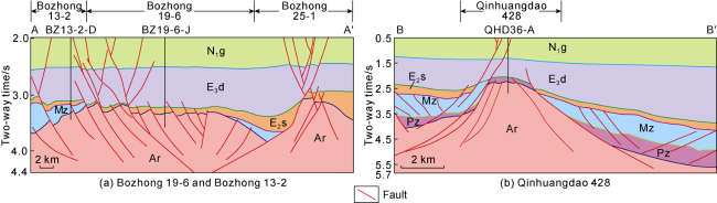
Fig. 2. Profiles of Bozhong 19-6, Bozhong 13-2 and Qinhuangdao 428 buried hills. Profile positions in |
2. Division of weathering crust and inner buried hill
Both EBH and CBH in the study area have experienced weathering to some degrees [1,3,5], resulting in weathering crust developed on the top of both types of buried hills, with different thickness. Statistics show that the thickness of the weathering crust in BZ19-6 EBH is the largest, with an average of approximately 215 m; the thickness of the weathering crust in BZ13-2 CBH overlaid by Mesozoic is moderate, with an average of approximately 93 m; and the thickness of the weathering crust in Qinhuangdao 428 CBH overlaid by Paleozoic is the thinnest, with an average of only approximately 23 m (Fig. 3 ). With the increase in the distance from the top, the weathering of the buried hill gradually weakened and even disappeared and finally entered the bedrock that was basically unaffected by weathering, namely, the inner buried hill (Fig. 3 ). Therefore, according to the degree of the vertical weathering effect, the Archaeozoic metamorphic buried hills in the study area can be vertically divided into two primary reservoir units: weathering crust and inner buried hill (Fig. 3 ).
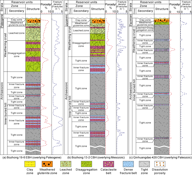
Fig. 3. Vertical reservoir structure model of Archaeozoic metamorphic buried hill in Bozhong Sag, Bohai Bay Basin. |
Weathering fractures and dissolution pores are typical identification marks of weathering crust [15]. However, an examination of the Archaeozoic buried hill reservoir in the study area shows that there are numerous fractures and dissolution pores in the inner buried hill [16], which result in great interferences and difficulties in identifying the weathering crust and the inner buried hill according to the development of fractures and dissolution pores. Both outcrops and drilling studies have shown that, as the influence of weathering on buried hills gradually weakens from the surface down, weathering fractures and dissolution pores in the weathering crust develop continuously from top to bottom and gradually decrease to the inner of the weathering crust [15]. However, the inner fracture zone and the associated dissolution pores in the inner buried hill are mostly formed by fluid dissolution through faults, and the rocks not affected by faults are relatively tight, resulting in the discontinuous development of the fracture zone and dissolution pores in the inner buried hill in the vertical direction [3]. For example, in Well BZ13-2-D (Fig. 4 ), quantitative description of fracture density and occurrence by FMI revealed that the fracture density was relatively high in the upper part of the well, and fractures developed continuously for 135 m from the top of the buried hill downward. In addition, in a tadpole diagram, the occurrence of fractures is complex, suggesting that fractures are of weathering origin. An analysis of the surface porosity of dissolution pores shows that all sidewall coring samples from the section with continuous fractures have dissolution pores of 2%-4%, and the porosity of this section is more than 3%, with a maximum value of 11%, indicating that dissolution pores are also developed continuously in the well from the top of the buried hill. Starting at a depth of 135 m from the top of the buried hill, the fractures identified by imaging logging data greatly reduces, dissolution pores are not developed, and the porosity is low, when entering the inner buried hill (Fig. 4 ). Several local fracture sections are developed in the inner buried hill in the well, showing a sudden increase in fracture density in the tight metamorphic rock. However, different from the fracture sections in the weathering crust, the occurrence of fractures on the tadpole map is mostly consistent, suggesting that the fractures may be of tectonic origin. In addition, both surface porosity and porosity analysis of the sidewall coring samples show that the location of dissolution pores in the inner buried hill in this well is highly consistent with the local fracture section, such as the section from 4810 m to 4850 m, resulting in several discontinuous dissolution pore zones distributed vertically (Fig. 4 ). According to the differences in the vertical continuity of fractures and dissolution pores, the weathering crust and the inner buried hill can be identified by logging data.
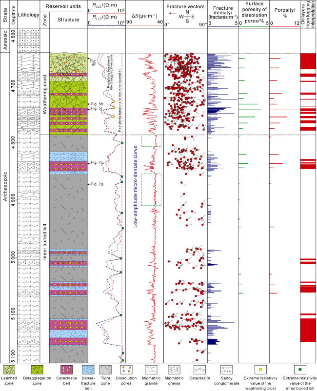
Fig. 4. Composite histogram in Well BZ13-2-D of Bozhong Sag, Bohai Bay Basin. GR—natural gamma; RLLD—deep lateral resistivity; RLLS—shallow lateral resistivity; Δt—acoustic time. |
(1) FMI logging: Based on the quantitative description of fracture density and occurrence by FMI logging, a continuous fracture section on the top of the metamorphic buried hill can be identified (Fig. 4 ), and the end of this continuous fracture section is regarded as a key base for dividing the boundary between the weathering crust and the inner buried hill.
(2) Resistivity curve: Statistics show that the maximum resistivity of the weathering crust of the metamorphic buried hill is much lower than that of the inner buried hill (Table 1 ). In this study, several extreme points on the resistivity curve whose resistivity reaches or approaches the highest value in metamorphic buried hills were selected. According to these resistivity extreme points, a vertical line was made, and named the "inner resistivity baseline". This baseline represents the resistivity value of the metamorphic buried hill, which is basically unaffected by weathering and fractures, and retains the original tight metamorphic rock (Fig. 4 ). Due to weathering, the maximum resistivity of the weathering crust of the buried hill is significantly less than the inner resistivity baseline. Therefore, from the top surface of the buried hill, the location where the resistivity value approaches or reaches the inner resistivity baseline for the first time can be considered the location of the boundary between the weathering crust and the inner buried hill (Fig. 4 ).
Table 1. Electrical parameters of different reservoir units in the Bozhong Sag, Bohai Bay Basin |
| Buried hill | Reservoir units | RLLD/(s·m) | Δt/(μs·m−1) | |
|---|---|---|---|---|
| Primary | Secondary | |||
| EBH | Weathering crust | Clay zone | 8-82 (19) | 63-103 (76) |
| Weathered glutenite zone | 11-725 (107) | 51-70 (61) | ||
| Leached zone | 10-4397 (193) | 50-81 (59) | ||
| Disaggregation zone | 25-5117 (352) | 49-66 (56) | ||
| Weathering crust superimposed with cataclasite belt | 4-11 864 (251) | 48-92 (64) | ||
| Inner buried hill | Inner fracture zone (cataclasite belt) | 4-6093 (275) | 51-81 (60) | |
| Inner fracture zone (dense-fracture belt) | 32-105 760 (5 307) | 49-65 (55) | ||
| Tight zone | 67-189 310 (9 321) | 49-59 (52) | ||
| CBH | Weathering crust | Clay zone | 0-340 (42) | 52-92 (64) |
| Weathered glutenite zone | 6-111 (16) | 52-100 (70) | ||
| Leached zone | 7-3800 (481) | 50-83 (53) | ||
| Disaggregation zone | 48-23 601 (1 433) | 50-58 (52) | ||
| Weathering crust superimposed with cataclasite belt | 30-7445 (773) | 48-68 (58) | ||
| Inner buried hill | Inner fracture zone (cataclasite belt) | 9-8797 (231) | 50-91 (63) | |
| Inner fracture zone (dense-fracture belt) | 31-82 054 (2 043) | 47-67 (54) | ||
| Tight zone | 147-102 045 (11 158) | 48-55 (51) | ||
Note: Data source from 27 wells in the study area. The statistics of the leached zone and the disaggregation zone in the weathering crust exclude the data from the superposed cataclasite belt. Values in brackets are average values. |
(3) Acoustic curve: Different from the resistivity curve, the acoustic time difference between the weathering crust and the inner buried hill is not obvious (Table 1 ), but there is a significant difference in curve morphology (Fig. 4 ). There are similar high-amplitude dentate box or finger patterns on the acoustic curves of the weathering crust and the inner buried hill, which are affected by fault superposition. But in the parts not affected by faults, the acoustic curves of the weathering crust show multiple combinations of moderate-small amplitude dentate box and finger shapes, while the curve of the inner buried hill shows a "flat low-amplitude micro-dentate" curve with high frequency and small amplitude (Fig. 4 ). The location of the first appearance of the flat low-amplitude micro-dentate curve shape can be identified as the boundary between the weathering crust and the inner buried hill.
3. Structural analysis of weathering crust and identification
According to weathering effects from strong to weak, the weathering crust of the Archaeozoic metamorphic buried hill can be further divided into four secondary reservoir units from top to bottom: clay zone, weathered glutenite zone, leached zone and disaggregation zone (Fig. 3 ). The reservoir space of these reservoir units is shown in Table 2 . Combining geological, conventional and imaging logging data, the four secondary reservoir units of weathering crust can be effectively identified.
Table 2. Reservoir space types and characteristics of different reservoir units in the Bozhong Sag, Bohai Bay Basin |
| Reservoir units | Reservoir space | ||
|---|---|---|---|
| Primary | Secondary | EBH | CBH |
| Weathering crust | Clay zone | No effective pores and fractures | No effective pores and fractures |
| Weathered glutenite zone | Intergranular pores with obvious weathering fractures enlarged by dissolution | Intergranular pores, basically filled | |
| Leached zone | Obvious weathering fractures enlarged by dissolution, and intracrystalline dissolved pores | Weathering fractures and intracrystalline dissolved pores | |
| Disaggregation zone | Weathering fractures (not filled), some intracrystalline dissolved pores | Weathering fractures (not fully filled), some intracrystalline dissolved pores | |
| Weathering crust superimposed with cataclasite belt | Interbreccia dissolved pores, intracrystalline dissolved pores, weathering fractures, tectonic fractures | Interbreccia dissolved pores, intracrystalline dissolved pores, weathering fractures, tectonic fissures | |
| Inner buried hill | Inner fracture zone (cataclasite belt) | Interbreccia dissolved pores, intragrystalline dissolved pores, tectonic fractures | Interbreccia dissolved pores, intracrystalline dissolved pores, tectonic fractures |
| Inner fracture zone (dense fracture belt) | Tectonic fractures, intracrystalline dissolved pores | Tectonic fractures, intracrystalline dissolved pores | |
| Tight zone | Tectonic fractures (mostly filled) | Tectonic fractures (mostly filled) | |
3.1. Geological characteristics of reservoir units in weathering crust
The clay zone is developed at the top of the weathering crust of the metamorphic buried hill (Fig. 3 ). It is the result of metamorphic fragmentation and claization caused by strong weathering and hydrolysis [3]. The average thickness of the clay zone is 1-2 m, and there is little difference between the CBH and the EBH (Fig. 3 ). The clay zone is composed of fine debris and a large number of clay minerals. Clay minerals, carbonate minerals (such as calcite), quartz and feldspar sand grains can be seen in the thin sections (Fig. 5 a). Due to the high content of fine-grained clay minerals in the clay zone, observations of thin cast sections indicate that dissolution pores and fractures are not developed in the clay zone (Fig. 5 a).
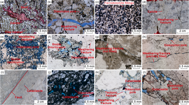
Fig. 5. Geological characteristics of the weathering crust of Archaeozoic metamorphic buried-hill in Bozhong Sag, Bohai Bay Basin. (a) Well QHD36-A, 3147 m, CBH, 0.5 m from the top surface of the buried hill, micrograph of clay zone; (b) Well BZ19-6-J, 4538 m, EBH, 13 m from the top surface of the buried hill, micrograph of weathered glutenite zone; (c) Well BZ13-2-A, 4930 m, CBH, 30 m from the top surface of the buried hill, micrograph of weathered glutenite zone; (d) Well BZ19-6-J, 4600.1-4600.2 m, EBH, 74 m from the top surface of the buried hill, core photograph of leached zone; (e) Well BZ19-6-J, 4600 m, EBH, 74 m from the top surface of the buried hill, micrograph of leached zone; (f) Well BZ13-2-D, 4653 m, EBH, 17 m from the top surface of the buried hill, micrograph of leached zone; (g) Well BZ19-6-J, 4672 m, EBH, 147 m from the top surface of the buried hill, micrograph of disaggregation zone; (h) Well BZ13-2-D, 4722 m, CBH, 87 m from the top surface of the buried hill, micrograph of disaggregation zone; (i) Well BZ19-6-J, 4595.5-4595.7 m, EBH, 70 m away from the top surface of the buried hill, core photograph of the leached zone superimposed with cataclasite belt; (j) Well BZ19-6-J, 4595 m, EBH, 70 m from the top surface of buried hill, micrograph of leached zone superimposed with cataclasite belt; (k) Well BZ13-2-C, 4676 m, EBH, 328 m from the top surface of buried hill, micrograph of disaggregation zone superimposed with cataclasite belt; (l) Well BZ13-2-D, 4742 m, CBH, 107 m from the top surface of buried hill, micrograph of disaggregation zone superimposed with cataclasite belt. |
The weathered glutenite zone developed under the clay zone (Fig. 3 ), which was formed by the rock disintegration of buried hills due to strong weathering and leaching[3]. Its thickness is slightly larger than that of the clay zone, with an average of 6-10 m. There is no significant difference in the thickness between the CBH and the EBH (Fig. 3 ). The weathered glutenite zone is mainly composed of sand and gravel formed by weathering and crushing of metamorphic rocks. The sorting and roundness of clastic particles are poor, and most of sand and gravel particles are subangular (Fig. 5 b, 5c). Intergranular pores and weathering fractures with obvious dissolution and expansion are developed in the weathered glutenite zone of the EBH (Fig. 5 b), but the intergranular pores in the weathered glutenite zone of the CBH are mostly filled with carbonate minerals such as ferrodolomite and calcite, and almost no effective pores developed (Fig. 5 c).
The leached zone has a large number of fractures and dissolved pores in the metamorphic rocks caused by strong leaching of atmospheric precipitation [15]. It is mainly developed under the weathered glutenite zone, but can also be directly exposed on the top of the buried hill because the weathered glutenite zone is denuded (Figs. 3 and 4 ). The thickness of the leached zone is different between the EBH and CBH. The average thickness of the leached zone in BZ 19-6 EBH is approximately 75 m (Fig. 3 a), that in the CBH covered by Mesozoic of BZ13-2 is approximately 35 m (Fig. 3 b), and that in the CBH covered by Paleozoic of Qinhuangdao 428 is the thinnest, typically less than 15 m, which is difficult to distinguish from the disaggregation zone (Fig. 3 c). Rock alteration in the leached zone is serious, and the minerals are calcilized, chloritized and kaolinized (Fig. 5 d-5f). The rocks in the leached zone of the EBH are semi-fractured and network weathering fractures are developed with exhibit dissolution and expansion (Fig. 5 d). In the cast thin section, intracrystalline dissolved pores are well developed (Fig. 5 e). Intracrystalline dissolved pores and network weathering fractures are also developed in the CBH, but the dissolution and expansion of weathering fractures is not obvious (Fig. 5 f).
Disaggregation zone. With the increase in the distance from the top surface of the buried hill, the leaching effect of atmospheric water weakens, and the leached zone gradually transitions into the disaggregation zone [15] (Fig. 3 ). The thickness of the disaggregation zone is usually larger than that of the leached zone, and the average thickness in the Bozhong 19-6 EBH may reach 130 m (Fig. 3 a). The average thickness in the Mesozoic covered CBH of BZ 13-2 is approximately 46 m (Fig. 3 b). In the Qinhuangdao 428 Paleozoic-covered CBH, the thickness is the thinnest (Fig. 3 c). Because it is located in the lower part of the weathering crust, dissolution and expansion cracks in the disaggregation zone are not developed, and mainly unfilled and semi-filled weathering fractures without dissolution expansion. Fractures are generally reticular and irregular in shape, and most of them are curved and arc-shaped and variable in appearance; and a small number of dissolution pores are developed (Fig. 5 g, 5h).
Weathering crust superimposed with cataclasite belt. Fault development in the weathering crust forms a local cataclasite belt (Fig. 3 a, 3b). The Paleozoic covered weathering crust of Qinhuangdao 428 CBH is thin, and the cataclasite belts are not superimposed (Fig. 3 c). The position of the weathering crust superimposed with the cataclasite belt shows that the degree of rock fragmentation and dissolution is strengthened [3]. For example, at 4595.5 m to 4595.7 m in Well BZ19-6-J, small faults and cataclasite belts on both sides of the faults can be identified in the core of the leached zone (Fig. 5 i). Thin sections also confirm that the rock is fragmented (Fig. 5 j). In addition to the leached zone, the disaggregation zone is also usually superimposed with the cataclasite belt (Fig. 3 ). For example, the depth at 4676.0 m in Well BZ13-2-C and that at 4742.0 m in Well BZ13-2-D correspond to the disaggregation zone, where fragmented breccia can be seen in cores and thin sections (Fig. 5 k, 5l). Influenced by the long-term activity of faults and fluid dissolution with faults as flowing channels[3], various types of reservoir spaces, such as dissolved pores between breccias, intracrystalline dissolved pores, weathered fractures and tectonic fractures, are developed in the weathered crust superimposed with the cataclasite belt (Fig. 5 j, 5k, 5l).
3.2. Logging identification of weathering-crust reservoir units
In this study, two logging parameters, acoustic time and resistivity, were selected to identify the secondary reservoir units according to the logging values and curve characteristics. The acoustic time and resistivity values of different reservoir units in the weathering crust are shown in Table 1 , and their morphological curve characteristics are as follows.
Clay zone: The resistivity and acoustic curves show high amplitude finger shapes (Fig. 6 a). Weathered glutenite zone: The resistivity and acoustic curves are both medium-high-amplitude dentate shapes (Fig. 6 b), and the FMI image shows high-resistivity bright crumby and brecciated bright spots against a low-resistivity dark background (Fig. 6 f-①, ②).
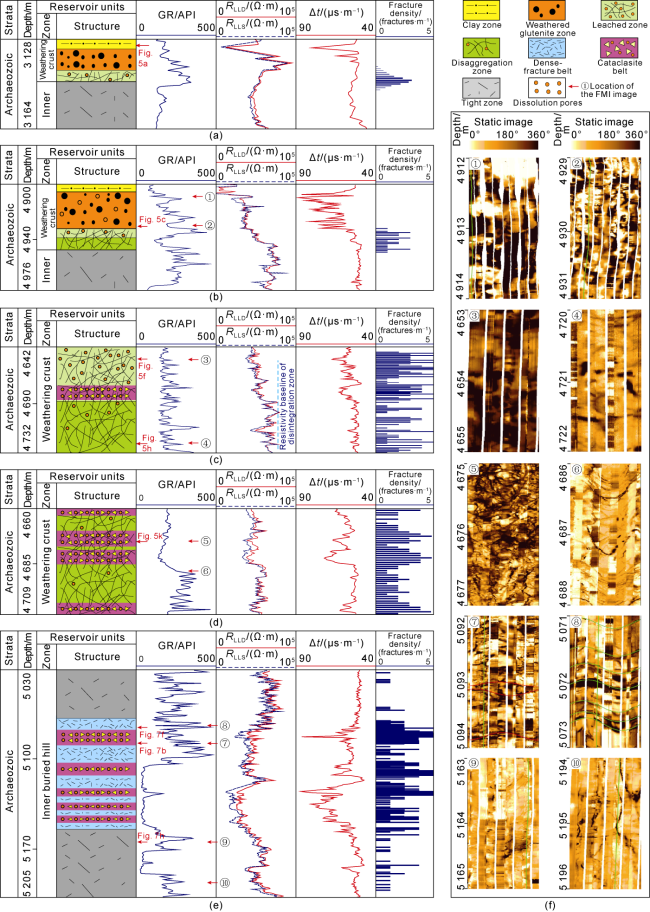
Fig. 6. Logging characteristics of reservoir units of Archaeozoic metamorphic buried hill in the Bozhong Sag, Bohai Bay Basin. (a) Typical conventional logging response characteristics of the clay zone (Well QHD36-A); (b) Typical conventional logging response characteristics of the weathered glutenite zone (Well BZ13-2-A); (c) Typical conventional logging response characteristics of the leached zone and the disaggregation zone (Well BZ13-2-D); (d) Typical conventional logging response characteristics of the weathering crust superimposed with cataclasite belt (Well BZ13-2-C); (e) Typical conventional logging response characteristics of the inner fractured zone and the tight zone (Well BZ13-2-A); (f) FMI characteristics of reservoir units. |
Leached zone: The resistivity curve is a combination of box, funnel and bell shapes with medium and high amplitudes, and the acoustic curve is a combination of dentate box and finger shapes with different amplitudes (Fig. 6 c). According to the observation on cores and sidetrack cores, it is found that the resistivity and acoustic curves with middle and high amplitude box shape, funnel shape and finger shape of the leached zone are the reflection of local fractures and the development of dissolution pores. For example, at 4653 m in Well BZ13-2-D in Fig. 6 c, the resistivity is in the shape of medium-high amplitude box, the acoustic curve is in medium-high amplitude finger shape, and dissolution pores are observable on the thin sections (Fig. 5 f). The resistivity images of the leached zone are generally dark, showing a wide irregular network of dark low-resistivity fractures and pores (Fig. 6 f-③). Disaggregation zone: The resistivity curve of the disaggregation zone is similar to that of the leached zone, with multiple combinations of medium- and high-amplitude box, funnel and bell shapes, while the acoustic curve shows multiple combinations of medium- and low-amplitude dentate box and finger shapes (Fig. 6 c). The difference is that the resistivity value of the disaggregation zone is overall higher than that of the leached zone (Table 1 ). The line connecting several maximum resistivity points constitutes the baseline of the disaggregation zone (Fig. 6 c). The resistivity of the leached zone is generally smaller than the baseline of the disaggregation zone, while the resistivity value of the disaggregation zone is generally larger than the baseline of the disaggregation zone. The acoustic curve of the disaggregation zone is composed of multiple combinations of low-medium amplitude finger shapes, with smaller amplitude compared with that in leached zone (Fig. 6 c). On the imaging log, the resistivity image of the disaggregation zone is slightly brighter than that of the leached zone, showing an irregular network of dark low-resistivity fractures and pores of different widths, but they are less than those in the disaggregation zone (Fig. 6 f-④). Weathering crust superimposed with cataclasite belt: In the parts of the leached zone and the disaggregation zone superimposed with cataclasite belts, the resistivity value decreases, and the acoustic time difference increases (Table 1 ). The resistivity curve is in a high-amplitude box shape, and the acoustic curve is in a high-amplitude box and finger shapes (Fig. 6 d). The imaging log shows clear fragmentation patterns (Fig. 6 f-⑤), which is in sharp contrast to the brighter and homogeneous image of the adjacent segment not superimposed with cataclasite belts (Fig. 6 f-⑥).
4. Structure and characteristics of the inner buried hill
4.1. Geological characteristics of the reservoir units of the inner buried hill
According to the differences in fracture density, the inner buried hill can be divided into two secondary reservoir units: inner fracture zone and tight zone (Fig. 3 ).
Inner fracture zone: The inner fracture zone is caused by faulting action. Cataclastic rocks develop near the fault plane, and the fractures are relatively dense within a certain distance on both sides of the faults [17⇓-19]. According to the spatial combination characteristics of cataclasite and fracture density, the inner fracture zone can be further subdivided into two belts: cataclasite belts near the fault plane and dense fracture belts on both sides of the faults [17] (Figs. 3 and 4 ). The rocks in the cataclasite belt are fragmented and composed of breccia and mineral detritus (Fig. 7 a-7c), and fault clay can be seen on some thin sections (Fig. 7 c). Influenced by fluid, kaolinization, calcitization and chloritization of feldspar and other minerals are more common (Fig. 7 a-7c). In the cataclasite belt, the broken structural breccia is easily dissolved under the interaction of fluid, forming dissolution pores between breccias, intracrystalline dissolution pores and matrix dissolution pores (Fig. 7 a-7c). The fracture density identified on the imaging log is relatively high. For example, at 4815-4850 m in Well BZ13-2-D, the fracture density is approximately 2-3 fractures/m, which is higher than that in the adjacent tight zone (Fig. 4 ). In the dense fracture belts on both sides of the cataclasite zone, tectonic fractures are well developed, and the tectonic fractures in thin sections are multiple groups of conjugate shear joints and ladder tracing tensile fractures formed along the conjugate shear joints in the early stage (Fig. 7 d, 7e). Dissolution pores can be formed along fractures by fluid dissolution at later stages (Fig. 7 d, 7f).
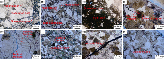
Fig. 7. Geological characteristics of the inner buried hill in the Bozhong Sag, Bohai Bay Basin. (a) Well BZ13-2-C, 4823 m, EBH, 475 m from the top surface of the buried hill, micrograph of inner fracture zone (with cataclasite belt); (b) Well BZ13-2-A, 5092 m, covered buried hill, 187 m from the top surface of the buried hill, micrograph of inner fracture zone (with cataclasite belt); (c) Well BZ13-2-D, 4836 m, CBH, 201 m from the top surface of the buried hill, micrograph of inner fracture zone (with cataclasite belt); (d) Well BZ13-6-J, 4815 m, EBH, 315 m from the top surface of the buried hill, micrograph of inner fracture zone (with dense-fractur belt); (e) Well BZ13-2-A, 5002 m, CBH, 99 m from the top surface of the buried hill, micrograph of inner fracture zone (with dense-fracture belt); (f) Well BZ13-2-A, 5071 m, CBH, 167 m from the top surface of the buried hill, micrograph of inner fracture zone (dense-fracture belt); (g) Well BZ13-2-D, 4 870 m, CBH, 234 m from the top surface of the buried hill, micrograph of tight zone, ankerite filled in fractures; (h) Well BZ13-2-A, 5164 m, CBH, 261 m from the top surface of the buried hill, micrograph of tight zone, calcite filled in fractures. |
Tight zone: In the inner buried hill, the part relatively far from faults is not affected by weathering or faulting action, so the lithology is relatively tight and uniform, forming the tight zone [17]. In Figs. 3 and 4 , the location far from the inner fracture zone is a tight zone with greatly reduced porosity and fracture density. Almost no dissolution pores are developed in the tight zone (Fig. 7 g, 7h). Due to regional stress, several groups of tectonic fractures are usually developed in the tight zone, but the fractures are almost filled, and most of them are fully filled by secondary minerals such as calcite and ankerite (Fig. 7 g, 7h).
Buried hills at different structural positions have different development characteristics of inner fracture zones [1,3]. The EBH of Bozhong 19-6 and the CBH of Bozhong 13-2 are located at the structures where strong Archaeozoic uplifting took place in the Indosinian period, resulting in a well-developed inner fracture zone [1,3,13]. The single layer thickness of the inner fracture zone is large, with an average of 43 m and a maximum of 130 m. The inner fracture zone makes up a large part, which accounts for approximately 40%-60% of the total thickness of the inner buried hill (Fig. 3 a, 3b). However, the Qinhuangdao 428 CBH has a relatively poor development of the inner fracture zone due to weak Indosinian uplifting [12]. The single layer thickness of the inner fracture zone is thin, with an average of 12 m and the maximum less than 23 m, and the inner fracture zone is small, accounting for approximately 15%-20% of the total inner buried hill (Fig. 3 c).
4.2. Logging identification of reservoir units in the inner buried hill
Inner fracture zone: The inner fracture zone has lower resistivity and higher acoustic time difference than that of the tight zone (Table 1 ). The resistivity curve shows a high-amplitude dentate box, funnel or bell shape (Fig. 6 e), while its acoustic curve shows a high-amplitude dentate box shape or the combination of multiple finger shapes under a background of flat and micro dentate curve. The center part of the combination of box shape and finger shape of the acoustic curve usually has the largest dentation amplitude, which corresponds to the cataclasite belt. The dentation amplitude decreases on both sides, corresponding to the dense-fracture belt (Fig. 6 e). On the imaging log, dense fractures and rock fragmentation patterns can be seen in the dense-fracture belt (Fig. 6 f-⑦). Although dark and low-resistivity fractures are developed in dense-fracture belts on the image, there is no fragmentation pattern (Fig. 6 f-⑧).
Tight zone: The resistivity of the tight zone is higher than that of the inner fracture zone (Table 1 ), and the resistivity curve is dentate to a low degree. The acoustic logging curve shows a "flat and low-amplitude micro-dentate" shape (Fig. 4 and Fig. 6 e). The imaging log shows a high-resistivity bright color, without fracture development (Fig. 6 f-⑨, ⑩).
5. Reservoir physical characteristics
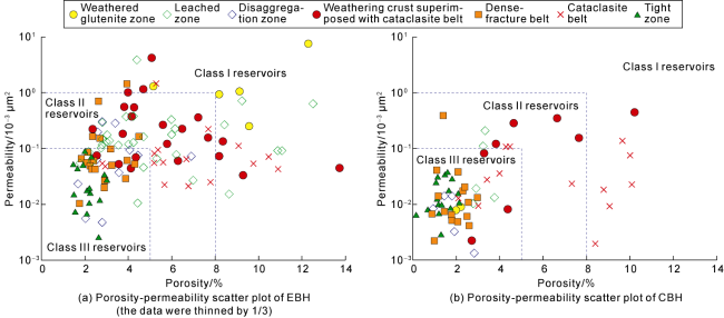
There are EBHs and CBHs developed in the study area. Both types of buried hills have weathering crust and inner reservoir units in the vertical direction. Due to different degrees of weathering and tectonic reconstruction, the physical properties of the reservoir units are different, and the reservoir types are not completely the same. According to the porosity and permeability, the reservoirs of Archaeozoic metamorphic buried hill can be divided into three classes: I-III reservoirs [20] (Fig. 8 ). For Class I reservoir, the porosity of is greater than 8% or the permeability is greater than 1×10⁻³ μm2, and the tested production is high. For Class II reservoir, the porosity is 5%-8% or the permeability is (0.1-1.0)×10−3 μm2, and the tested production is medium. For Class III reservoir, the porosity is less than 5%, the permeability is less than 0.1×10⁻³ μm2, and the production test indicates low or no production.
5.1. Exposed buried hill
The weathered glutenite zone, the leached zone and the weathering crust superimposed with cataclasite belts are three reservoir units with good physical properties in the EBH in the study area. The porosity of the weathered glutenite zone is 5.1%-12.3%, the permeability is (0.260- 7.860)×10−3 μm2, and the reservoirs are all Class I (Fig. 8 a). The porosity of the leached zone is 1.8%-12.5%, the permeability is (0.011-3.910)×10−3 μm2, the average effective fracture density identified by FMI is 2.7 fractures/m, and the reservoirs are mainly Class I and Class II (Fig. 8 a). The porosity and permeability of the weathering crust superimposed with cataclasite belts are 2.3%-13.8% and (0.032-4.196)×10−3 μm2, respectively. The average effective fracture density identified by FMI is 2.9 fractures/m, and the reservoirs are mainly Class I and Class II (Fig. 8 a). With good physical properties of the reservoirs in the weathered glutenite zone and the leached zone, there is usually a favorable reservoir zone with large thickness and relatively continuous development on the top of the EBH. The porosity is the largest at the top of the weathered glutenite zone or the leached zone and decreases gradually to the bottom. The fracture density is generally high, with small local fluctuations (Fig. 3 a). Downward entering the disaggregation zone, the porosity is 1.8%-6.9% and the permeability is (0.005-0.301)×10−3 μm2 under the influence of relatively poor reservoir physical properties, and the average effective fracture density identified by FMI is 1.9 fractures/m. The reservoirs are mainly Class III, and favorable reservoirs are mostly developed on cataclasite belts (Fig. 8 a). Therefore, favorable reservoirs in the lower part of the weathered crust of the EBH gradually become intermittent, and there are usually several discontinuous locations with abnormally high values of porosity and fracture density (Fig. 3 a).
Fig. 8. Types and physical properties of reservoirs of Archaeozoic metamorphic buried hill in the Bozhong Sag, Bohai Bay Basin (reservoir classification according to Reference [20]). |
Except for the weathering crust, favorable reservoirs were also developed in the cataclasite belt of the inner fracture zone. In Fig. 8 a, the cataclasite belt mainly falls into Class I and Class II reservoir zones, with porosity ranging from 2.8% to 10.9% and permeability of (0.021-1.461)×10−3 μm2. The average effective fracture density identified by FMI is 3.6 fractures/m, indicating that dissolution pores and fractures are well developed in the inner fracture zone of the EBH. The porosity of the tight zone is 1.5%-3.0%, the permeability is (0.003-0.086)×10−3 μm2, the average effective fracture density identified by FMI is less than 0.5 fractures/m, and the reservoirs are all Class III. The inner fracture zone is partitioned by the tight zone, resulting in several favorable reservoir zones with vertical interphase distribution in the inner buried hill. The porosity and fracture density curves have several discontinuous peaks, and the favorable reservoirs are relatively thicker in the thicker part of the inner fracture zones (Fig. 3 a). The favorable reservoir of the EBH is obviously controlled by weathering and tectonic actions, so it is attributed into dual controlled reservoir by weathering and tectonics.
5.2. Covered buried hill
The weathered crust of the CBH in the study area is thinner than that of the EBH (Fig. 3 b, 3c), and the reservoir physical properties are relatively poor (Fig. 8 b). Weathering crust superimposed with the cataclasite belt and the cataclasite belt in the inner fracture zone are two reservoir units with the most favorable reservoir conditions in the CBH in the study area. The porosity of the weathering crust superimposed with the cataclasite belt is 2.8%-10.2%, the permeability is (0.002-0.459)×10−3 μm2, and the average effective fracture density identified by FMI is 3.5 fractures/m. The porosity of the cataclasite belt in the inner fracture zone is 2.1%-10.1%, the permeability is (0.002-0.134)×10−3μm2, and the average effective fracture density identified by FMI is 2.1 fractures/m (Fig. 8 b). The two reservoir units are dominated by Class I and Class II reservoirs. The formation of these two favorable reservoir units is closely related to tectonic action, indicating that tectonic transformation is more important for the formation of favorable reservoirs in the CBH than weathering.
6. Conclusions
Archaeozoic metamorphic buried hills in the Bozhong Sag, Bohai Bay Basin can be vertically divided into two primary reservoir units: weathering crust and inner buried hill. The weathering crust can be divided into four secondary reservoir units: clay zone, weathered glutenite zone, leached zone and disaggregation zone. The inner buried hill can be divided into two secondary reservoir units: inner fracture zone and tight zone, and the inner fracture zone can be further divided into cataclasite belt and dense fracture belt.
The position where the continuous fracture segment starting from the top surface of the buried hill ends on the FMI, where the resistivity first approaches or reaches the "inner resistivity baseline" on the resistivity log, and where the "flat and low-amplitude micro-dentate" curve first appears on the acoustic curve is a reliable location that divides the boundary between the weathering crust and the inner buried hill. Secondary reservoir units, such as the clay zone, the weathered glutenite zone, the leached zone, the disaggregation zone, the inner fracture zone and the tight zone, can be identified.
Favorable reservoirs in the EBH are mainly developed in the weathered glutenite zone, the leached zone, the weathering crust superimposed with the cataclasite belt and the cataclasite belt in the inner fracture zone. They are weathering and tectonically controlled reservoirs. The CBH is less affected by weathering than the exposed buried hill. The reservoirs are mainly developed in the weathering crust superimposed with the cataclasite belt and the cataclasite belt in the inner fracture zone.