

Introduction
Petroleum system refers to a natural hydrocarbon fluid system in a basin [1]. It contains a set of effective source rock and related oil and gas, static geological elements such as source rocks, reservoirs and caprocks necessary for the formation of hydrocarbon reservoirs, and dynamic geological processes such as trap evolution and hydrocarbon generation, migration and accumulation [2⇓⇓⇓⇓-7]. Two sets of source rocks developed in the Shahezi Formation and the Yingcheng Formation with large distribution areas are distributed in the Lower Cretaceous in the northern Songliao Basin (hereinafter referred to as Songbei) [8-9]. The gas-bearing system with the Shahezi Formation as the main gas source has been successfully explored [10⇓-12]. The research on the source rock and hydrocarbons of the Yingcheng Formation is relatively insufficient. Although some scholars have pointed out that the source rock of the Yingcheng Formation may contribute to hydrocarbon accumulation [13-14], no enough evidences have been found on the properties of the hydrocarbon generated by the source rock of the Yingcheng Formation, or field examples proved it could accumulate in a large quantity or form new petroleum systems, limited by the accuracy and multi-solution of oil-gas source correlation, and previous researches of the high to over mature source rock as the object [15-16]. In addition, previous studies on clastic reservoirs of Yingcheng Formation and Denglouku Formation mainly focused on large depressions inside the basin (such as Xujiaweizi fault depression). Because the reservoirs are relatively small in scale and tight, coupled with the absence of large oil and gas exploration discovery, the exploration potential of these two formations has not attracted enough attention.
In Shuangcheng area of Songbei, an oil-bearing system with mudstones in the Yingcheng Formation as the source rocks and sandstones of the Denglouku Formation as main reservoirs was found. A breakthrough in oil exploration has been made in this area. The oil discovery in Shuangcheng area began in 2013, when Well A, which was drilled in the subsag, revealed 67 m of organic-rich mudstone and 6.2 m of oil-bearing sandy conglomerates sandwiched by dark mudstones in the Yingcheng Formation. Low-yield oil flow (0.24 t/d) was obtained after the oil-bearing interval was fractured. In 2016, Well B was drilled in the high part of a structural trap. Oil-bearing sandstones of 8.2 m were found in the Denglouku Formation, and 10.2 t/d industrial oil flow was obtained after fracturing. In 2018, on the basis of 3D seismic data, fine structural interpretation and reservoir prediction, wells C, D, E and F were deployed in the east, north and south. All wells have achieved the expected results, with the highest natural productivity of 90.97 d/t. Since 2019, under the guidance of the integration of exploration and development, 13 exploration and evaluation wells have been deployed, and an oil-bearing area of 15.3 km2 has been delineated. Moreover, Well J found 4.4 m of oil-bearing dark mudstones and thin siltstones in the Yingcheng Formation. Industrial oil flow (3.21 t/d) was obtained after the oil-bearing interval was fractured, suggesting a shale oil exploration potential of the Yingcheng Formation.
Until now, only a few studies have been conducted on the source rocks of the Yingcheng Formation and reservoirs in the Yingcheng Formation and Denglouku Formation in Shuangcheng area. For example, Sun et al. [17] pointed out that the Yingcheng Formation developed high-quality source rocks through TOC measurement and rock pyrolysis, and predicted the thickness and distribution of the source rocks through 3D seismic data. We reconstructed the forming environment of the source rocks in the Yingcheng Formation through core observation and trace element data, and analyzed their hydrocarbon generation and expulsion potential through basin simulation methods [18]. Additionally, we analyzed the physical properties and pore structures of the sandstone reservoirs in the Denglouku Formation, and divided them into three categories based on empirical statistics and pore-throat structure parameters [19]. Zeng et al. [20] concluded that the crude oil in Shuangcheng area was related to the source rocks in the Yingcheng Formation through the study of biomarkers [20]. In fact, the study on the source rocks, reservoirs and cap rocks is still insufficient, especially on the trap evolution, oil and gas accumulation and reservoir types. As a result, we know little about the reservoir-forming characteristics of this oil-bearing assemblage. Based on drilling practice, systematic rock sample tests and basin simulation, this paper analyses the characteristics of the source rocks, reservoirs and caprocks, as well as the processes of hydrocarbon generation, trap evolution and oil charging, with the purpose to establish the relationship between geological elements and geological processes of hydrocarbon system. On this basis, the favorable factors of petroleum accumulation are summarized, and suggestions for further exploration are put forward.
1. Geological setting
Located at the southeast of the Songliao Basin, the Shuangcheng area covers the Shuangcheng, Miaotaizi and Yingshan sags (Fig. 1 a). This study took the Shuangcheng sag as the research object, which is rich in drilling and testing data and has broken through in oil exploration. The study area is distributed in the NNE direction, covering an area of about 500 km2 (Fig. 1 b). The Jurassic Huoshiling Formation (J3hs), Lower Cretaceous Yingcheng Formation (K1yc), Denglouku Formation (K1d) and Quantou Formation (K1q) are developed in the deep part of the study area. Most of the Upper Cretaceous has been denuded, with some parts of Qingshankou Formation (K1qn) remained (Fig. 1 c). Early stratigraphic filling is similar to that of Songliao Basin. Volcanoes started erupting during the sedimentary period of Huoshiling Formation, forming lithological assemblage of volcanic rocks and clastic rocks. During the depositional period of the Shahezi Formation (K1sh), the rifting activities were intensified [21] while faulting activities were weak in the study area, resulting in the undeveloped Shahezi Formation. Massive volcanic eruption occurred intensively in the early stage of the Yingcheng Formation, but weakened at the end of the deposition of the Yingcheng Formation, and a set of clastic rocks dominated by lacustrine mudstones were deposited. According to the zircon dating and sporopollen analysis data, the volcanic rocks and clastic rocks belong to the first and fourth members of the Yingcheng Formation, respectively. After the deposition of the Yingcheng Formation, rifting tended to terminate and tectonic uplifting occurred, resulting in only the third and fourth members being deposited in the middle and late stages of the Denglouku Formation. The sedimentary scope of the Quantou Formation expanded in the depression period (Fig. 1 d). The current buried depth of the top surface of the 4th member of the Yingcheng Formation (Ying 4 Member) in the study area is generally 1300-1600 m with a thickness of generally 100-400 m. The lithologies are mainly dark mudstones interbedded with thin sandstones in the central part of the sag. Toward the edge of the sag, dark mudstones interbedded with sandy conglomerates dominate. The current buried depth of the top surface of the Denglouku Formation is generally 900-1300 m, with a thickness of generally 300-600 m. From bottom to top of the Denglouku Formation, there are mainly conglomerates, sandstones and mudstones. Proven reserves have been identified and successfully developed in the Denglouku Formation (see Table 1 for the typical oil testing results of exploratory well). Because of the shallow buried depth and high oil content of the reservoir, good economic benefits have been achieved.

Fig. 1. Structural units and stratigraphic column in the study area (section location shown in |
Table 1. Oil production and physical properties from typical exploration wells drilled in Shuangcheng area |
| Well | Horizon | Depth/m | Perforation | Oil production/ (t•d−1) | Oil density/ (g•cm−3) | Viscosity/ (mPa•s) | Wax content/ % | Freezing point/°C | |
|---|---|---|---|---|---|---|---|---|---|
| Thickness/ m | Number of layers | ||||||||
| B | Deng 3 (K1d3) | 1140.0-1150.5 | 8.0 | 3 | 10.02 | 0.834 | 7.5 | 9.9 | 28 |
| B | Deng 3 (K1d3) | 1185.5-1187.0 | 1.5 | 1 | 25.68 | 0.823 | 5.4 | 24.7 | 29 |
| C | Deng 3 (K1d3) | 1168.0-1175.2 | 5.4 | 2 | 2.72 | 0.836 | 9.6 | 24.0 | 31 |
| D | Deng 3 (K1d3) | 1150.0-1187.7 | 14.3 | 7 | 90.97 | 0.824 | 6.1 | 24.8 | 31 |
| E | Deng 3 (K1d3) | 1194.2-1197.6 | 2.8 | 2 | 4.22 | 0.838 | 8.2 | 25.0 | 29 |
| E | Deng 3 (K1d3) | 1173.8-1188.8 | 7.8 | 4 | 3.60 | 0.834 | 7.9 | 24.2 | 28 |
| F | Deng 3 (K1d3) | 1179.8-1188.6 | 6.8 | 3 | 21.96 | 0.832 | 9.2 | 23.1 | 28 |
| F | Deng 3 (K1d3) | 1166.0-1175.2 | 8.6 | 1 | 3.48 | 0.832 | 8.0 | 22.9 | 31 |
| G | Deng 3 (K1d3) | 1192.8-1200.8 | 8.0 | 1 | 6.20 | 0.829 | 7.7 | 19.6 | 34 |
| H | Deng 3 (K1d3) | 1118.4-1148.6 | 15.4 | 7 | 33.84 | 0.833 | 9.5 | 25.5 | 33 |
| A | Ying 4 (K1yc4) | 1415.0-1427.4 | 6.2 | 3 | 0.24 | 0.835 | 4.1 | 13.4 | 24 |
| J | Ying 4 (K1yc4) | 1357.0-1390.5 | 4.4 | 3 | 3.21 | 0.841 | 6.2 | 20.1 | 20 |
| H | Ying 4 (K1yc4) | 1238.6-1239.2 | 0.6 | 1 | 0.54 | 0.846 | 9.6 | 24.4 | 33 |
2. Petroleum accumulation conditions
2.1. Hydrocarbon source rock and oil-source correlation
Unlike the Xujiaweizi and other large fault depressions (the main exploration targets in the past) where two sets of main source rocks (Shahezi Formation and the Yingcheng Formation) were developed, only one set of source rock was found in the Lower Cretaceous in the study area. The source rock is developed on the volcanic rock. The zircon age of the volcanic rock (about 110 Ma) and the typical pollen assemblages (ancient pine and cypress pollen and Fixospora) found in the source rock indicate that it belongs to the Yingcheng Formation (namly the Ying 4 Member). The lithologies of source rocks are mainly dark mudstones, with local tuffaceous mudstones and bentonites. The source rock is generally 20-100 m thick, and gradually becomes thinner from the center of the subsag to the edge [17].
The abundance of organic matter of the source rock is related to lithology. The average TOC values of different source rocks are more than 2.0% (Table 2 ), reaching the level of high-quality source rocks [22]. The vitrinite reflectance (Ro) of the source rock is 0.80%-1.25%. The Tmax is 446-469 °C (the peak value is about 455 °C). The average OEP value is 1.06. The average CPI value is 1.16. The maturity parameters above indicate that the source rock is in the mature stage (Table 2 ). According to TOC logging evaluation method [23⇓-25], the cumulative thickness of the high-quality source rock is generally 10-50 m (the thickness of single layer is generally 2-5 m).
Table 2. Statistics of geochemical indicators of source rocks |
| Lithology | TOC/% | Chloroform A/% | (S1+S2)/(mg•g-1) | IH/(mg•g-1) | Tmax/°C | Ro/% | OEP | CPI |
|---|---|---|---|---|---|---|---|---|
| Grey mudstone | 0.78-4.84 2.05(85) | 0.020-0.291 0.059(11) | 0.62-13.88 3.70(85) | 47.7-412.8 149.7(85) | 446-457 452(85) | 0.81-1.04 0.95(5) | 1.05-1.15 1.11(6) | 1.07-1.17 1.08(6) |
| Grey-black mudstone Black mudstone | 0.78-8.16 2.86(298) | 0.020-0.670 0.164(75) | 0.41-22.51 6.73(298) | 46.4-409.2 205.9(298) | 438-469 452(298) | 0.80-1.25 0.99(24) | 1.01-1.17 1.07(24) | 1.07-1.22 1.09(24) |
| Tuffaceous mudstone | 2.92-4.06 3.35(5) | 0.105 | 5.07-10.44 6.85(5) | 161.7-235.6 185.1(5) | 447-453 451(5) | 0.90 | 1.03-1.14 1.06(2) | 1.08-1.18 1.07(2) |
Note: The numerator represents the value range, the denominator represents average value, and the value in bracket represents the number of samples. |
The sources and types of organic matters were studied by several methods. Lamalginite and vitrinite were found in the whole rock microscopic observation (Fig. 2 ). Inertinite was observed in some samples which were greatly affected by terrestrial input (Fig. 2 ). The Tmax-IH chart (Fig. 3 a) shows that types II1-II2 organic matter are dominant. The TOC-S2 chart reveals that the organic matter is mainly Type II (Fig. 3 b) with some Type III organic matter. Except for two samples taken at the edge of the subsag, which revealed that there may be terrestrial organic matter input, the regular sterane triangle diagram shows that plankton and algae are the main sources of organic matter (Fig. 3 c). The main peak carbon of normal alkane of the mudstone is C17-C19, and C25-C27 in some samples (Fig. 3 d), reflecting the source of the organic matter is dominated by lower aquatic organisms and also contributed by higher terrestrial plants. Considering that the values of IH and S2 in Fig. 3 a and Fig. 3 b are obviously lower than their original values probably because a large amount of hydrocarbon has been expelled from the source rock, which leads to the deterioration of the organic matter types. We finally concluded that the organic matter mainly came from lower aquatic organisms, accompanied by the input of terrigenous clasts. The formation of the high-quality source rock in the study area is closely related to volcanic activities (described in another paper).
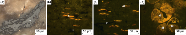
Fig. 2. Photomicrographs of source rocks of the Yingcheng Formation in Shuangcheng area. (a) Transmission light, 1423.59 m, Well A; (b) Blue light, 1437.75 m, Well C; (c) Blue light, 1442.45 m, Well C; (d) Blue light, 1258.00 m, Well D. al—lamalginite; v—vitrinite; in—inertinite. |
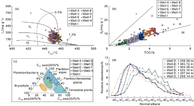
Fig. 3. Sources of organic matters in source rocks of the Yingcheng Formation in Shuangcheng area. (a) Relationship between Tmax and IH; (b) Relationship between TOC and S2; (c) Triangle diagram of regular sterane; (d) Carbon number distribution of normal alkane. |
The crude oil in the study area is characterized by high freezing point (greater than 20 °C), high wax content (more than 13%) and low density (density less than 0.9 g/cm3) (Table 1 ). It’s concluded that the petroleum discovered is from the source rock of the Ying 4 Member based on the analysis of oil-source correlation and geological background of petroleum accumulation. The source rock of the Qingshankou Formation in the study area haven’t been mature, because it can’t consist with the isomerization index for C29 steranes (20S/(20S+20R) and ββ/(αα+ββ)) [26-27], which indicate that oil is generated from mature source rocks (Fig. 4 a). The gammacerane content in the crude oil is obviously lower than that in the source rock of the Qingshankou Formation and the oil generated [28]. The carbon isotope of the normal paraffin monomer (−32.7‰ to −28.8‰, averaged −30.99‰) is higher than that in the source rock of the Qingshankou Formation (−35‰ to −31‰) [29] and the oil generated (generally −33‰ to −30‰). Based on the above analysis, the possibility that the crude oil came from the source rock of the Qingshankou Formation can be ignored. Due to the shielding of the Duiqingshan uplift, oil from other sags couldn't migrate to the Yingcheng Formation and the Denglouku Formation in the study area. Therefore, the possibility that the crude oil came from the source rocks in adjacent sags can be ruled out, too. Crude oil samples show similar carbon isotope values and distribution patterns of monomer hydrocarbons with those source rocks in the Yingcheng Formation (Fig. 4 b). They also have the same distribution patterns of steroid and terpenoid biomarkers (Fig. 5 ). In other words, the sterane composition is mainly C27 rearranged sterane (C27Dia) and C29 rearranged sterane (C29Dia), and the terpane compound is mainly hopane, with lower gammacerane (Ga) content and higher rearranged hopane content [20].
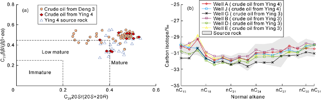
Fig. 4. Geochemical characteristics of Yingcheng Formation source rock and crude oil from Yingcheng-Denglouku formations. (a) Crossplot of C2920S/(20S+20R) and C29ββ/(αα+ββ); (b) Carbon isotopic composition distribution and normal alkane of source rock and crude oil [20]. |
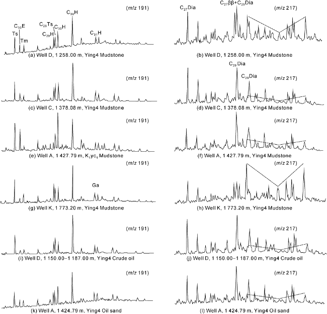
Fig. 5. Typical sterterpene mass spectra of source rock and oil in the Yingcheng Formation in Shuangcheng sag [20]. |
2.2. Reservoir and caprock conditions
The Ying 4 Member in the study area is mainly of lacustrine facies, followed by fan delta facies. The Denglouku Formation is mainly of alluvial fan facies, fluvial facies and delta facies (Fig. 6 ). Controlled by sedimentary facies, two types of reservoirs, sandstone and sandy conglomerate, are mainly developed.
Fig. 6. Physical properties, oil-bearing and pore structure characteristics of the reservoir in Shuangcheng area. |
The reservoirs in the Denglouku Formation are mainly developed in the middle and upper parts of the 3rd member of Denglouku Formation (Deng 3 Member) where delta plain and delta front are dominant The lithologies are mainly feldspathic sandstones, followed by lithic feldspathic sandstones. Pores in the reservoir are mainly primary intergranular pores (Fig. 7 a-7d), followed by intergranular dissolution pores (Fig. 7 e-7f). When the contents of clay (Fig. 7 c-7e) and carbonate minerals (Fig. 7 d) increase, the pore volume decreases obviously. Generally, the porosity is mainly 5.0%-20.0%, the permeability mostly (proportion of 75.7%) greater than 10×10−3 μm2. The permeability of the oil-immersed reservoir in the same tectonic setting exceeds 10×10−3 μm2 (Fig. 6 ). The diagram of pore-throat radius and permeability reveals that when the permeability exceeds 10×10−3 μm2, the pore-throat radius increases rapidly and the connectivity of pore throat becomes better obviously.
Fig. 7. Pore characteristics in the reservoirs in Shuangcheng area. (a) Primary intergranular pores, lithic feldspar sandstone, Denglouku Formation, Well D, 1153.98 m; (b) Primary intergranular pores, feldspar sandstone, Denglouku Formation, Well D, 1172.87 m; (c) Primary intergranular pores, anisometric sandstone, Denglouku Formation, Well D, 1149.84 m; (d) Primary intergranular pores, calcareous feldspar sandstone, Denglouku Formation, Well D, 1173.55 m; (e) Intergranular volcanic dissolved pores, tuffaceous sandstone, Denglouku Formation, Well D, 1193.91 m; (f) Intergranular feldspar dissolution pores, feldspar sandstone, Denglouku Formation, Well D, 1168.53 m; (g) Intragranular dissolved pores, sandy conglomerate, Ying 4 Member, Well K, 1501.42 m; (h) Intragranular and intergranular dissolution pores, sandy conglomerate, Ying 4 Member, Well K, 1436.74 m; (i) Intergranular dissolution pores, sandy conglomerate, Ying 4 Member, Well K, 1449.76 m. Q—quartz; F—feldspar; R—rock debris; Ca—calcium. |
The sandy conglomerate reservoirs in the Ying 4 Member are mainly in fan delta plain and fan delta front subfacies (Fig. 6 ). The conglomerate is mainly composed of tuff and rhyolite whose diameters are generally 5-20 mm. The grains are sub-angular and sub-round (Fig. 7 g, 7h). Reservoir space is mainly intergranular dissolution pores (Fig. 7 g-7i) and intragranular dissolution pores (Fig. 7 g) and a few air holes on the surface of rhyolite particles (Fig. 7 i). The porosity is mainly 5.0% to 15.0%. The permeability is generally less than 1×10⁻³ μm2. The oil-immersed reservoirs generally show permeability greater than 1×10⁻³ μm2. Similar to the sandstone reservoirs in the Denglouku Formation, when the permeability of the sandy conglomerate in the Ying 4 Member exceeds 1×10⁻³ μm2, the pore throat radius increases rapidly and pore throat connectivity becomes better.
Delta plain facies is widely developed in the Ying 4 Member (Fig. 6 ). The lithology is mainly purple mudstone that accounts for 75%-90% of the total thickness of the stratum. The formation thickness of Deng 4 Member is generally 70-110 m, which directly covers the oil-bearing sandstone in the Deng 3 Member and serves as the direct cap rock of the oil reservoir. Furthermore, the mudstones widely developed in the Quantou Formation, Qingshankou Formation and Nenjiang Formation also act as regional cap rocks.
2.3. Trap formation and evolution
The formation of structural traps in the study area is controlled by three main tectonic activities: compression at the end of the deposition of the Yingcheng Formation, strike-slip at the end of the deposition of the Quantou Formation and structural inversion at the end of the deposition of the Nenjiang Formation [30], namely evolution stages of “gestating, developing and finalizing” (Fig. 8 ). (1) Stage of gestation. The strata deposited in the ancient uplift zone (such as Well D) were bent and deformed under the compressive stress at the end of the deposition of the Yingcheng Formation, which laid the foundation for the formation of structural traps (Fig. 8 a). (2) Stage of development. A series of NNE-striking faults [31] were formed under the left-handed torsional stress at the end of the deposition of the Quantou Formation. The vertical fault distance of most faults (generally less than 50 m) was smaller than the thickness of the cap rock (generally 70-100 m). The sandstone reservoirs in the foot wall of the fault were laterally butted with the mudstones in the hanging wall, forming a series of sealable fault blocks (Fig. 8 b). (3) Stage of finalization. Compressed by the nearly WE stress at the end of the deposition of the Nenjiang Formation [32], the stratum was further bent and uplifted. As a result, the amplitude of the trap increased, forming multiple fault block traps under the background of large anticline structures (Fig. 8 c and Fig. 1 b).
Fig. 8. Structural evolution of Shuangcheng area (see |
2.4. Petroleum accumulation process
Inclusion type and homogenization temperature have been widely used in the study of hydrocarbon accumulation history [33⇓-35]. By comprehensive analysis of structural evolution history, burial history, hydrocarbon generation history, occurrence state and homogenization temperature of inclusions, we speculated that there were two stages of oil charging in the study area.
The first stage of petroleum accumulation took place at the late Cretaceous (76-82 Ma). During this period (corresponding to the sedimentary period of the Nenjiang Formation), the source rocks of Yingcheng Formation had been matured (Ro was close to 0.9%, Fig. 9 ) and reached the hydrocarbon expulsion threshold [18]. In the meantime, the structural traps of the Denglouku Formation had taken shape. The oil generated from the source rocks could migrate to the structural traps along the channels such as faults and unconformities. The oil inclusions reflecting the oil charging in this period are mainly distributed in the micro-cracks in the secondary enlarged edge of quartz or those not cutting through the secondary enlarged edge of quartz (Fig. 9 ), indicating that they were captured before the enlargement of quartz. The oil inclusions are brown and light brown under reflected light, and bright yellow and green yellow fluorescence under ultraviolet light. The peak value of homogenization temperature of brine inclusions associated with oil inclusions is 110-130 °C, corresponding a petroleum accumulation period of 76-82 Ma.
Fig. 9. Source rocks evolution, petroleum accumulation and petroleum system events in Shuangcheng area. |
The second stage of petroleum accumulation was from the late Paleogene to the middle Neogene (12-28 Ma). After the first stage of hydrocarbon charging, the source rocks of the Ying 4 Member continued to generate hydrocarbons until the end of the Nenjiang Formation deposition when the tectonic uplifting started, resulting in the termination of hydrocarbon generation and further uplifting of early traps. It’s speculated that the decompression and capacity expansion caused by the tectonic uplifting stimulated the second stage of petroleum accumulation during Late Paleogene-Middle Neogene [36]. The oil inclusions reflecting the second stage of hydrocarbon charging were captured after the enlargement of quartz (Fig. 9 ), and mainly distributed in the micro-fractures running through the quartz clastic particles (including the enlarged edge). The oil inclusions are brown and light brown under reflected light, and bright yellow and yellow-green fluorescence under ultraviolet light. The homogenization temperature peak of the brine inclusions associated with oil inclusions is 70-90 °C.
It should be noted that, although the formation temperature in the early Late Cretaceous is consistent with the homogenization temperature of the inclusions at 70-90 °C (Fig. 9 ), the source rocks in that period were not yet or just mature. It is not in line with the mature oil in the study area, and contrary to the inclusion occurrence state which suggests that the temperature range corresponding to the second stage of hydrocarbon charging. In addition, although the gas chromatography and mass spectrometry of the oil in the study area showed no such parameters reflecting biodegradation as "UCM" bulges, 25-norhopane and demethyl tricyclic terpane, indicating that the oil reservoir has not been significantly damaged. Nevertheless, from the related reports in other areas [37] and the fact that the oil layer in the lower part of the same reservoir obtained oil shows but tested to be water layers, indicating possible adjustment taking place in the early reservoirs (such as uplifted oil-water interface). For example, the trap located at the west side of the depression in Fig. 1 b had a low amplitude in the late Cretaceous, but after the compression at the end of the deposition of the Nenjiang Formation, the trap amplitude increased and the oil-water interface rose, resulting in the sandstone reservoir located at the original oil-water interface obtained oil shows, but were proved to be a water layer.
2.5. Model of petroleum accumulation
The Yingcheng Formation and the Denglouku Formation form a complete petroleum system where the Yingcheng Formation provides source rocks, the sandstones in the Denglouku Formation and the sandy conglomerates in the Yingcheng Formation are effective reservoirs, and the mudstone in the Deng 4 Member is the direct caprock. The vertical distance from the middle of the source rock to the bottom of the cap rock is generally less than 200 m, so the oil migrates to the reservoirs only through a short transport (the lateral migration distance less than 10 km). Two types of petroleum accumulation models are developed in the study area, that is, structural reservoir and structural-lithologic reservoir.
Structural-lithologic reservoirs are developed in the Ying 4 Member in the slope zone. They have no uniform oil-water interface (Fig. 10 ). The relatively-high permeability reservoirs in the high structural part of the same sand body are the main oil-bearing reservoirs (the structural low part contains water). The oil yield of the reservoirs after fracturing is 0.24-3.21 t/d.
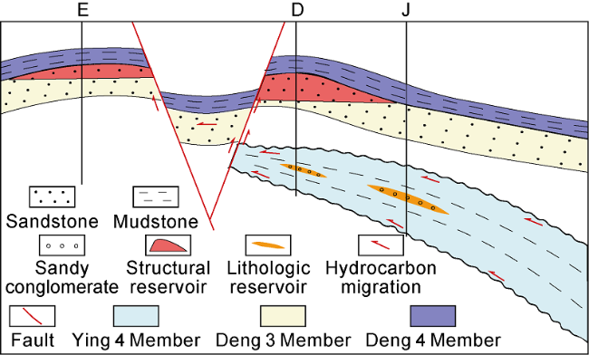
Fig. 10. Petroleum accumulation model in Shuangcheng area (see |
Structural reservoirs are mainly distributed in fault blocks and faulted anticline traps of the Denglouku Formation, with the characteristic of “one block to one reservoir”. As the reservoirs are far away from the hydrocarbon-generating subsag, the oil-bearing height of the reservoirs tends to decrease (Fig. 10 ). The natural yield of this kind of reservoirs after a conventional test was generally 4.23-33.84 t/d, with the highest of 90.97 t/d. The good source-reservoir-cap rock combination, late oil charging, short-distance migration and stable structural background are favorable factors for reservoir formation.
3. Petroleum geological significance and enlightenment
The source rocks of the Yingcheng Formation are widely developed in Songbei, but their thickness is thinner than that of the Shahezi Formation. In addition, no concentrated high-quality source rocks have been found in the past, and no direct evidence could prove that the source rocks generated a large amount of hydrocarbons. As a result, the resource potential of the source rocks of the Yingcheng Formation has not been paid enough attention. After the discovery of oil and gas generated by source rocks of the Yingcheng Formation in the Denglouku Formation, and considering the petroleum geological analysis, a series of new revelations have been obtained. (1) High-quality source rocks of the Yingcheng Formation were found in small sags located at the edge of the basin (Fig. 11 ). This may indicate that adjacent sags (such as the Miaotaizi sag and the Yingshan sag) and large depressions (such as the Xujiaweizi fault depression) located at the center part of the basin may also develop high-quality source rocks, especially where drilling data has revealed high-quality source rocks [38]. Meanwhile, the source rocks of the Yingcheng Formation are rich in organic matter, and have thin siltstone interlayers (1-2 m). Industrial oil flow has been obtained by the existing vertical well (Well J), so the potential of shale oil cannot be ignored. (2) This study found a direct evidence for the accumulation of oil generated by the high-quality source rocks of the Yingcheng Formation. It confirmed the small-scale high-quality source rocks have the hydrocarbon potential to develop industrial oil reservoirs. More importantly, this discovery helps liberating the "confinement" of "scale" to the source rocks to some extent, and helps to promote the transformation of source rock evaluation from "scale" to "quality". (3) The main source rocks in previous studies in Songbei have been in the evolution stage of high to over mature, so their gas potential is the focus now. The discovery of mature source rocks and oil in Shuangcheng area reveals that the oil potential and exploration potential is also worthy of attention to the deep source rocks. (4) The hydrocarbon supply potential of the deep source rocks to the overlying strata is also an issue worthy of attention, and may provide new ideas for some controversial issues in hydrocarbon exploration. For example, it is possible that any oil in the Fuyu reservoirs was from the source rocks of the Yingcheng Formation or the Shahezi Formation besides the Qingshankou Formation [39]? Since the deep source rocks of the Yingcheng Formation and the Shahezi Formation have an oil-generating capability [40-41] and there is no shortage of hydrocarbon transport faults, this possibility can't be denied at present.
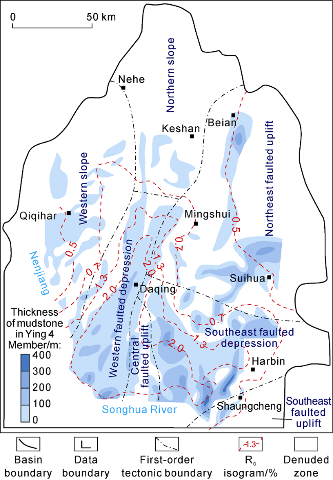
Fig. 11. Distribution of mudstone thickness and thermal evolution of the Ying 4 Member in Songbei. |
The thickness distribution of the mudstone in the Yingcheng Formation in Songbei was predicted by using seismic and drilling data. And then, the potential areas of petroleum exploration were predicted according to the thermal evolution degree (Ro less than 1.3%). Combining with the preliminary work, it is suggested to focus on Suihua and Beian areas in the near future. In the faulted depressions with high thermal evolution degree located inside the basin, the organic matters are in a highly mature stage (Ro value is greater than 1.3%). Since condensate oil and oil-type gas generated by source rocks of Shahezi Formation have been found, it is necessary to pay attention to whether the source rocks of the Yingcheng Formation provided petroleum for the overlying strata in their geological period. Based on the above knowledge, it is suggested to strengthen the research on the distribution law, sedimentary environment, hydrocarbon generation features and evolution of the source rocks in the Yingcheng Formation.
4. Conclusions
An oil-bearing assemblage was discovered in the Shuangcheng area, which is composed of source rocks in the Yingcheng Formation, sandstone reservoirs in the Denglouku Formation and sandy conglomerate reservoirs in the Ying 4 Member, and mudstone caprock in the Deng 4 Member. This paper revealed the good hydrocarbon generation potential of the high-quality source rocks in the Yingcheng Formation, and provided an oil field example where petroleum generated by source rocks of the Yingcheng Formation and accumulated with high efficiency.
In Shuangcheng area, the hydrocarbon was generated in the sedimentary period from Yaojia Formation to Nenjiang Formation. The traps experienced three stages of evolution (i.e., gestating, developing and finalizing), and petroleum accumulation happened in two stages, the Nenjiang Formation and the Paleogene-Neogene. Two reservoir models (structural and structural-lithologic) were developed in the Denglouku Formation and the Ying 4 Member. Although the high-quality source rocks are on a small scale, good source-reservoir-cap rock combination, late oil charging, short distance migration and stable structural background are favorable factors for effective hydrocarbon accumulation and preservation.
The discovery of high-quality source rocks and related oil in the Yingcheng Formation suggest that there be sapropelic source rocks on a certain scale, besides coal-bearing source rocks that generate gas in deep Songbei. In the future, deep researches should focus on the sedimentary environment, hydrocarbon generation features and evolution, and resource potential of the source rocks in the Yingcheng Formation.
Nomenclature
CPI—carbon predom index of normal alkane;
GR—natural gamma ray, API;
IH—hydrogen index mg/g;
OEP—odd-even predom of normal alkanes;
Ro—vitrinite reflectance, %;
Rt—resistivity, Ω·m;
S1—free hydrocarbon content, mg/g;
S2—pyrolysis hydrocarbon content, mg/g;
Tmax—peak temperature of rock pyrolysis, °C.