

Introduction
Tectonic paleogeomorphology and the stratigraphic filling process under its control play an important role in controlling the differentiation of carbonate deposits, es-pecially the slope break belt with breaks [1], which usually develops favorable facies or sedimentary systems for enrichment and accumulation of oil and gas [2]. In the Sichuan Basin, major breakthroughs in oil and gas exploration of deep marine carbonate reservoirs are often related to the discovery of uplifts and depressions and slope break belts. For example, the platform-edge slope break belt around the Kaijiang-Liangping Trough developed during the key compression-tension transition period of the Hercynian tectonic cycle controls the development and distribution of Permian and Triassic reef shoal gas fields with reserves of nearly one trillion cubic meters in Puguang, Yuanba, Dukouhe, Luojiazhai, Wubaiti and Longgang areas [3]. Similarly, the platform-edge slope break belt around the Mianyang-Anyue rift trough developed during the key tension-compression transition period of the Tongwan-Caledonian tectonic cycle controls the distribution of large and super-large Sinian-Cambrian shoal gas fields in Weiyuan, Anyue and northern slope of central Sichuan Basin [4]. The important controlling effect of slope break belt on sedimentation, reservoir and oil and gas accumulation has been revealed. However, most of the existing studies focus on the fault-step slope break belt or the flexure slope break belt formed on rifting background [5], but the characteristics, mechanism and shoal-controlling/reservoir-controlling of the slope break belt developed in compressive settings were seldom reported, restricting the oil and gas exploration of carbonate reservoirs on this kind of sedimentary background.
The Cambrian Xixiangchi Formation in the Sichuan Basin is in a compressional environment [6-7]. Drilling data show grain shoal- and shoal-controlled reservoirs of the Xixiangchi Formation are mostly submeter-level thin rhythmic superposition [8]. However, large-scale shoal reservoirs were discovered in the eastern and central parts of the Sichuan Basin through wells PQ1 and GT2 [9], indicating that the Xixiangchi Formation may have large-scale reservoirs. Unclear development and distribution law restricts the exploration process of the Xixiangchi Formation reservoir. It is well known that the development of facies-controlled carbonate reservoirs is controlled by paleogeographic uplifts and depressions or depositional geomorphology, and the key to solving this issue is to clarify the stratigraphic filling process and model. Previous studies mainly relied on field outcrops and well logging data, and believed that except for the truncation at the top near the paleo-uplift, the inner strata of Xixiangchi Formation were completely developed [10-11], with changes in thickness only. According to this filling model, such a large thickness difference in the south-eastern direction of the paleo-uplift can only be explained as a south-eastern foreset, and deepwater deposits should occur in the high-value zone, but it is not supported by real data [12]. In view of this, on the basis of summarizing the previous research results, a series of data were fully used including data of 82 drilling wells, 7 coring wells (GT2, NC7, BL1, H12, LG1, WH1, WY1H), 2D seismic data of 2 065 km and 3D seismic data of 10 115 km2 (Gaoshiti-Moxi 3D block and Weiyuan 3D block) in the study area. Through the analysis of the filling pattern of the well-seismic strata, the strata filling process and pre-sedimentary paleogeomorphology of the Xixiangchi Formation are discussed, revealing the correlation between the paleogeomorphology and the distribution of grain shoal and reservoirs, and proposes favorable exploration zones.
1. Geological setting
Located in the northwestern part of the South China Plate, the Sichuan Basin is a huge rhomb-shaped sedimentary basin. After several periods of tectonic movement, the present tectonic pattern is formed [13], covering about 19×104 km2. The study area is the gentle slope zone of the central Sichuan paleo-uplift (Fig. 1a ), where the Leshan-Longnüsi paleo-uplift and the trans-Mianyang- Anyue rift trough are two most important geological units.
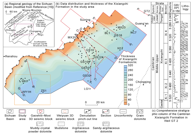
Fig. 1. Thickness and comprehensive stratigraphic column of the Xixiangchi Formation in the study area (GR—gamma ray). |
Upwardly, the Cambrian in the Sichuan Basin can be divided into the Lower Cambrian Maidiping Formation (—C1m), Qiongzhusi Formation (—C1q), Canglangpu Formation (—C1c), Longwangmiao Formation (—C1l), Middle Cambrian Gaotai Formation (—C2G) and Middle and Upper Cambrian Xixiangchi Formation (—C2-3x) [14]. During the sedimentary period of the Early Cambrian Qiongzhusi Formation, large-scale transgression occurred and resulted in shelf argillaceous deposits in a relatively deep-sea environment [15]. From the Canglangpu Formation to the Longwangmiao Formation, carbonate deposits appeared under the control of regression [16-17]. During the sedimentary period of the Gaotai Formation, the sedimentary environment was gradually restricted due to regression, exposed structural highs and lateral accretion in structural lows, resulting in evaporite deposits developed locally and carbonate platform expanding further [18]. Due to the influence of continuous transgression, when the Xixiangchi Formation deposited, the sedimentary range gradually expanded, and the basin was generally confined to platform deposits [19]. According to the properties of lithology and electricity, and seismic sections (Figs. 2 and 3 ), the Xixiangchi Formation in the study area can be divided into four members upwardly. The Xi 1 and Xi 2 members at the bottom are argillaceous dolomite with muddy-crystal powder dolomite and grain dolomite. The Xi 3 and Xi 4 members at the middle and upper parts are grain dolomite with muddy-crystal powder dolomite (Fig. 1c ).
In the Early Cambrian, under the influence of regional stretching from northeast to southwest, a large intra- cratonic rift developed in the Mianyang-Anyue area [20]. In the middle and late Early Cambrian, the rift trough was gradually filled and evolved into an intra-platform sag. At that time, the basin structure was relatively stable,and mainly dominated by stable subsidence [21]. In the Middle-Late Cambrian when the Xixiangchi Formation began to deposit, the paleogeographic pattern plunged from NW to SE, and the formation became sharply thick toward southeast (Fig. 1b ).
2. Stratigraphic filling and multistage overlap slope break belts
2.1. The paleo-geomorphology of multistage slope break belts
The top and bottom of the Cambrian Xixiangchi Formation in the Sichuan Basin are easily identified by the distinct unconformities between them and upper and lower formations (Fig. 1c ). However, unclear filling process and the division of inner strata restricts restrict the establishment of the stratigraphic filling model and the restoration of the paleo-environment. Early internal stratigraphic division relies on field outcrops, cores, well logging and isotope stratigraphy [22]. It is believed that the stratigraphic development of various submembers is complete except for the absence of top strata due to denudation of the nearby Leshan-Longnüsi paleo-uplift. This filling model can only be explained by the deepwater foreset model, but it is in contradiction with the fact that no deepwater deposits have been found in both wells and basin edge outcrops. Based on the synthetic seismogram from around 82 wells and the calibration of the top and bottom of the Xixiangchi Formation, the strata change rapidly in multiple steps from the paleo-uplift southward on the nearly-NS seismic section across wells MX201- GS10-GS108-GS124-GS101-GS32 (Fig. 2 ). At every point of rapid thickness change, the seismic events reflect an overlap pinch-out phenomenon, while truncation appears only near the pinch-out line of the Leshan-Longnüsi paleo-uplift.
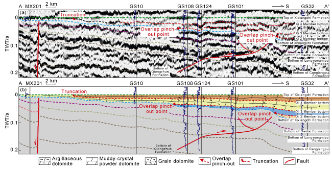
Fig. 2. Overlapped filling and shallow-water overlap model featured by "bottom overlap and top truncation" on the seismic section of the Xixiangchi Formation (section location shown in |
This phenomenon indicates that the filling model of the Xixiangchi Formation is characterized by overlapping from the periphery to the paleo-uplift, rather than the abovementioned foreset filling model. According to this filling model, it is reasonable that there is no deepwater deposit in the high-value zone, and indicates that the internal of the Xixiangchi Formation should not follow the traditional principle that each well area is completely developed. However, it should follow the shallow-water overlap model featured by “bottom overlap and top truncation” since the deposition started from the periphery to paleo-uplift. Under the guidance of this new shallow-water overlap sedimentary model, abrupt changes represent the slope break points (Fig. 2 ). Although the quality of the seismic data from the southern slope of the paleo-uplift is poor due to the overlap of the Huayingshan fault and fold, the slope break belts are widespread on the southeast trending seismic section (Fig. 3 ).
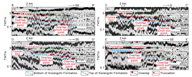
Fig. 3. Locations of the overlap pinch-out points on the seismic section of the study area (section location shown in |
The phenomenon of gradual overlap and filling toward the high part of the paleo-uplift shows that the deposition of the Xixiangchi Formation took place on the paleogeomorphic background of high in the west and low in the east. The NW strata were denuded, indicating that the NW strata were always in high geomorphic areas without structural inversion, and deposited on the background of continuous uplifting. Therefore, the top of the Xixiangchi Formation can be used as a better reference surface for paleo-geomorphic restoration in the study area. Although the Xixiangchi Formation suffered varying degrees of denudation caused by the Caledonian Movement at the paleo-structural high, the strata at the top of the paleo-uplift are generally thin. The denudation correction to the general characteristics of the paleo-geomorphology and plane restoration of the slope break belt can be negligible in the study area. After tracking the top and bottom of the Xixiangchi Formation based on 2 065 km 2D and 10 115 km2 3D seismic data, and using the impression method to invert the pre-depositional paleogeomorphology of the Xixiangchi Formation, it is found that the Xixiangchi Formation generally becomes thick in time domain toward southeast, and there are three zones where its thickness changes abruptly largely in well blocks WY1H-ZS1-GS32-H12-NC7 and WH1-GS108- GS16-BL1-MX23 and the southern margin of the paleo- uplift. The slope break belt adjacent to the paleo-uplift was caused by late erosion, and the other two are overlap slope break belts. Along the direction to the paleo-uplift, they are called the first and the second overlap slope break belts and the third denudation slope break belt, which reveal that the paleo-geomorphology of the southern slope of the paleo-uplift is featured by a multistage slope break dipping toward southeast (Fig. 4 ).
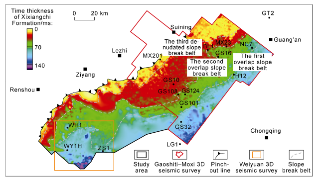
Fig. 4. Time thickness and plane distribution of the slope break belts of the Cambrian Xixiangchi Formation on the southern slope of the Leshan-Longnüsi paleo-uplift. |
2.2. Multistage slope break belts and shallow-water overlap deposits
2.2.1. Internal stratigraphic division
According to the overlapped filling model and the results of well-seismic calibration, and considering well and mud logging data and gamma cycles, the inner strata of the Xixiangchi Formation can be divided into 4 members upwardly. Their interface characteristics are shown below.
The top and bottom interfaces of the Xixiangchi Formation are regional parallel unconformities and lithologic conversion surface (Fig. 1c ). It is easy to distinguish high-gamma mudstone from muddy-crystal powder dolomite or grain dolomite on both sides (Fig. 5 ). The top seismic events are marked as peaks, while the bottom seismic events are troughs, which are easy to trace and compare (Figs. 2 and 3 ).
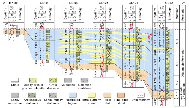
Fig. 5. Interface characteristics and classification comparison of internal layers of the Xixiangchi Formation (section location shown in |
The inner stratigraphic interfaces correspond to lithologic conversion surfaces (Fig. 5 ). Below the interface is grain dolomite or muddy-crystal powder dolomite with low gamma values. The gamma values above the interface drift forward, and the lithology is mostly argillaceous dolomite. The seismic events are all calibrated as peaks, and traceable and comparable (Figs. 2 and 3 ).
2.2.2. Vertical and horizontal distribution and filling model of inner strata of the Xixiangchi Formation
Based on the above scheme, the inner strata in 82 wells were redivided, and the corresponding well-seismic section was established (Figs. 2 and 5 ). It’s found that the Xixiangchi Formation became thin significantly toward the paleo-uplift, which is caused by late deposition of the third and the fourth members. The Xixiangchi Formation in Well MX201 adjacent to the paleo-uplift became thin due to Caledonian-Hercynian denudation (Fig. 5 ). Vertically, thin shoals are mainly developed in the third and the fourth members. Laterally, thin shoals are concentrated around the wells near the first and the second overlap slope break belts, indicating a certain coupling relationship between overlap slope break belts and grain shoals (Fig. 5 ).
During the sedimentary period of the Xi 1 Member, the Middle-Late Cambrian Xixiangchi Formation began to deposit after regression and exposed unconformity formed in the Middle Cambrian Gaotai Formation. The Upper Yangtze Platform continued settling, and the seawater began to invade from the southern margin of the paleo-uplift, and remained in the first overlap slope break belt around wells WY1H-ZS1-GS32-H12-NC7 for a long time. The deposits were formed into the Xi 1 Member. At that time, the sedimentary range was small due to restricted sea water and low energy. The Xi 1 Member was thin in the range of 0-40 m, and gradually thickened toward southeast (Fig. 6a ). During the sedimentary period of Xi 2 Member, under the continuous influence of slow transgression, seawater affected the second overlap slope break belt around wells WH1-GS108-GS16-MX23, and stagnated there for a long time. As a result, the second member appeared, which was 0 to 80 m, and thickened toward southeast (Fig. 6b ). At that time, the sedimentary range was still small, and sea area was restricted with low energy. Transgression reached its maximum in the Late Cambrian when the Xi 3 Member began to deposit. The paleogeomorphology tended to be flat with the filling of Xi 1 and Xi 2 members. At that time, the sedimentary range reached the maximum while the energy recovered, which was conducive to the development of grain shoals. Influenced by the denudation of the Caledonian and Hercynian movements, the strata adjacent to the paleo-uplift were thin in the northwest and thick in the southeast, generally 0 to 140 m (Fig. 6c ). Early deposition of the Xi 4 Member was successive in range and seawater energy compared to the third member (Fig. 6d ), while the late deposition suffered seawater retreating toward southeast and tended to accrete laterally, probably influenced by tectonic compression and increasing difference between uplift and depression. At that time, the sedimentary range decreased and the seawater energy became weak, which was not conducive to the development of grain shoals, resulting in low-energy deposits (Fig. 5 ).
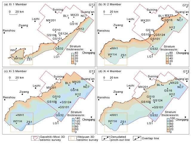
Fig. 6. Thickness contours of the four members of the Xixiangchi Formation in the study area. |
3. Coupling relationship between multistage slope break belts and grain shoals and shoal-controlled reservoirs
3.1. Coupling relationship between multistage slope break belts and grain shoals
Previous studies have shown that the Xixiangchi Formation is characterized by the development of thin-layer grain dolomite [23]. Based on the systematic macro- and micro-analysis of 6 wells drilled in the southern slope of the Leshan-Longnüsi paleo-uplift, it is found that the Xixiangchi Formation is mainly composed of thin grain dolomite (with terrigenous sandstone locally), powdered and fine crystalline dolomite, muddy-crystal powder dolomite and a small amount of dolomitic quartz sandstone (Fig. 7 ).

Fig. 7. Rock types of the Cambrian Xixiangchi Formation on the southern slope of the Leshan-Longnüsi paleo-uplift. (a) Gray massive muddy-crystal powder dolomite, Xi 4 Member, 4 617.60-4 617.69 m, Well BL1, core; (b) muddy-crystal powder dolomite with reticular fractures (microscopic feature in |
The muddy-crystal powder dolomite is gray or greenish-gray, blocky (Fig. 7a ), with fine grains (Fig. 7b ) formed in confined sea or inter-shoal sea below the wave base. Grain dolomite is primarily arenaceous dolomite (Fig. 7c and 7d), followed by oolitic dolomite (Fig. 7e , 7f) and a small amount of gravel dolomite (Fig. 7g , 7h). Because washed above the wave base, the color of the grain dolomite is almost light gray, and the primary rock fabric was damaged by late recrystallization, showing the characteristics of crystalline dolomite (Fig. 7i , 7j). The grain dolomite may mix with terrigenous quartz into sandy grain dolomite. Vertically, the grains are in an inverse sequence, and accumulate into barrier, intra-platform or peritidal shoals. In addition, in the late high-stand system tract, terrigenous sediments accumulated rapidly, and its bottom was usually an exposed erosion surface with normal-grading grains (Fig. 7k ), generally thin dolomitic quartz sandstone (Fig. 7l ). For example, the normal-grading dolomitic quartz sandstone at 4 995.18-4 995.23 m in Well NC7 may be tidal flat depositing with early transgression (Fig. 7k , 7l). In addition, it also indicates that the Leshan-Longnüsi paleo-uplift during the sedimentary period of the Xixiangchi Formation had the source supply capacity. It should be the paleo-continent, rather than denudated after depositing.
3.1.1. Vertical development of grain shoals
Drilling data show that the Xixiangchi Formation is characterized by the development of thin shoal body, which has typical characteristics of thin single shoal body, rapid lateral change, and multi-layer superposition in the longitudinal direction (Fig. 8 ). According to the statistics of 113 high-frequency development cycles of shoal in 3 wells (GT2, BL1 and NC7), the thickness of a shoal is 0.08-2.30 m, which is generally less than 1 m. In the 45.03 m long section cored continuously at 5 314.72-5 359.75 m in Well GT2, 49 high-frequency upwardly- shallowing sequences were identified, namely 49 groups of shoals, 0.09-2.30 m thick each, with an average thickness of about 0.74 m and a cumulative thickness of 36.49 m. In the 30.4 m section continuously cored at 4 615.95-4 646.35 m in Well BL1, 41 high-frequency upwardly-shallowing sequences were identified, and include 37 groups of shoals, about 0.08-1.19 m each, with an average of 0.52 m and a cumulative thickness of grain shoal of 19.27 m. In Well NC7, 23 high-frequency upwardly-shallowing cycles were identified by two systematic coring tests at 4990.77-4 997.67 m and 5 024.86-5 033.87 m, including 23 groups of shoals, about 0.08-1.04 m each, 0.46 m on average, and 10.67 m cumulatively (Fig. 9 ).
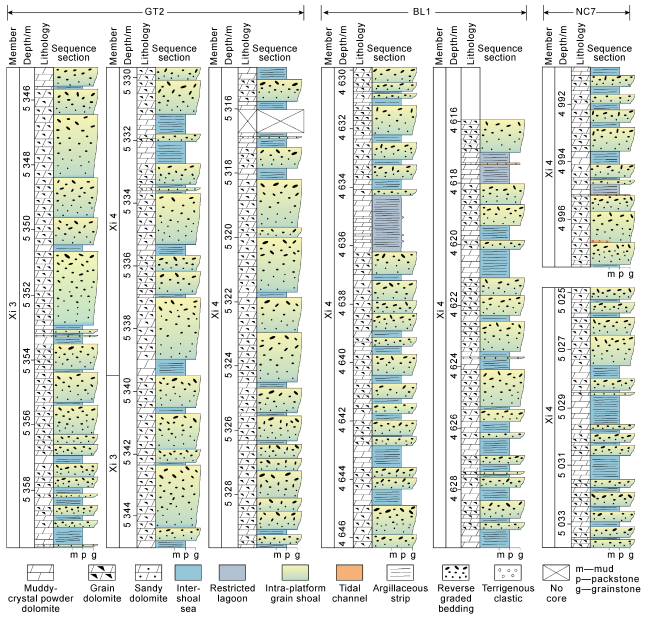
Fig. 8. Sedimentary facies sequences in the cored wells in the study area. |
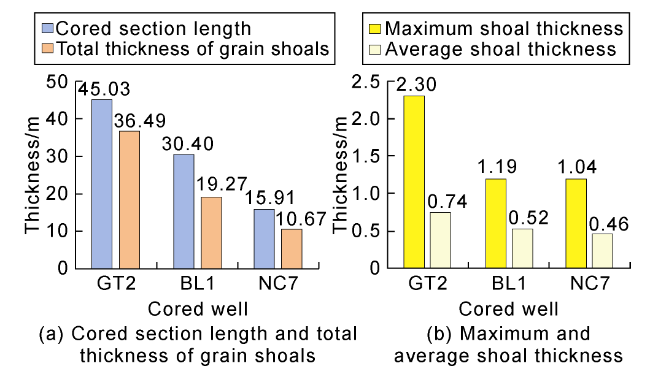
Fig. 9. Histogram of shoal thickness in cored wells of the Xixiangchi Formation in the study area. |
The lower part of a typical shoal sequence is gray micrite dolomite or greenish-gray argillaceous dolomite, indicating that it deposited in a low energy environment below the wave base, which can be interpreted as restricted sea or inter-shoal sea. As water became shallower due to sediment accumulation, the sedimentary base level was gradually above the wave base, which is characterized by the development of high-energy grain shoal deposits, and then the typical upwardly shallowing sequence in restricted lagoon or inter-shoal sea was formed. Of course, in a micro-geomorphic highland, it can be on the wave base for a long time, with low-energy inter-shoal sea deposits missing, so thin shoals directly superimposed with each other vertically (Fig. 8 ).
3.1.2. Plane distribution of grain shoals and their coupling relationship with multistage slope break belts
It is noteworthy that, from the profile perpendicular to the paleo-uplift, thin grain shoals are concentrated in the seaward side of the overlap pinch-out (Fig. 5 ), indicating that the vertically superimposed grain shoals are controlled by the overlap slope break belt. Based on the logging and core data from 82 wells, the cumulative thickness of the grain shoal of each well was calculated, combined with the seismic section through the cumulatively thickest grain shoals, the grain shoals are typically hummocky and chaotic reflections (Fig. 10 ). According to this characteristic, the development area of the grain shoal was delineated, combined with the cumulative thickness statistics of the grain shoal of a single well, the plane distribution of grain shoals of the Xixiangchi Formation was mapped in the study area (Fig. 11 ). The grain shoals with large cumulative thickness are distributed (1) in the overlap slope break belt around the Leshan-Longnüsi paleo-uplift, and others locally; (2) around wells WH1-GS101-GS108-GS124-GS16-BL1-MX23 (where the cumulative thickness exceeds 50 m) and overlapping with the seaward side of the second slope break belt; and (3) around wells WY1H-ZS1-H12-NC7 and extending toward northeast to Well GT2, where the cumulative maximum thickness is over 50 m, but the area with thicker shoal body decreases overall compared with the second overlap slope break belt and overlap with the first slope break belt in the seaward side.
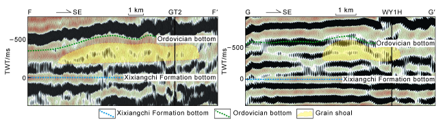
Fig. 10. Seismic sections of the shoal bodies and shoal-controlled reservoirs of the Xixiangchi Formation (Xixiangchi Formation bottom flattening; section location in |
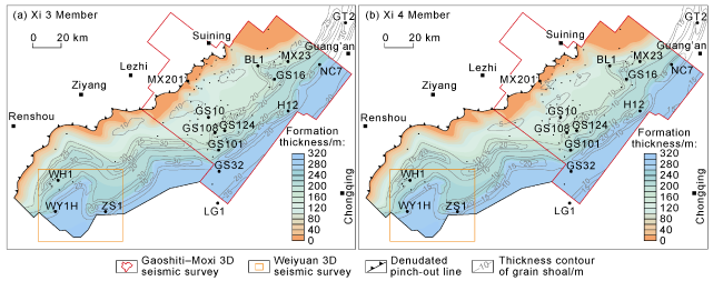
Fig. 11. Thickness contours of grain shoals of Xi 3 and Xi 4 members in the study area. |
3.2. Coupling relationship between multistage slope break and shoal-controlled reservoirs
3.2.1. Xixiangchi Formation characterized by the development of shoal-controlled reservoirs
As mentioned above, the lithology of the Xixiangchi Formation in the study area is simple, mainly grain dolomite, powdered-fine crystalline dolomite and muddy- crystal powder dolomite, but not all of can develop into reservoirs. According to the analysis of systematic coring, cuttings and thin sections in the study area, the reservoirs with macropores are almost developed in grain dolomite and powdered-fine dolomite (Fig. 12 ).
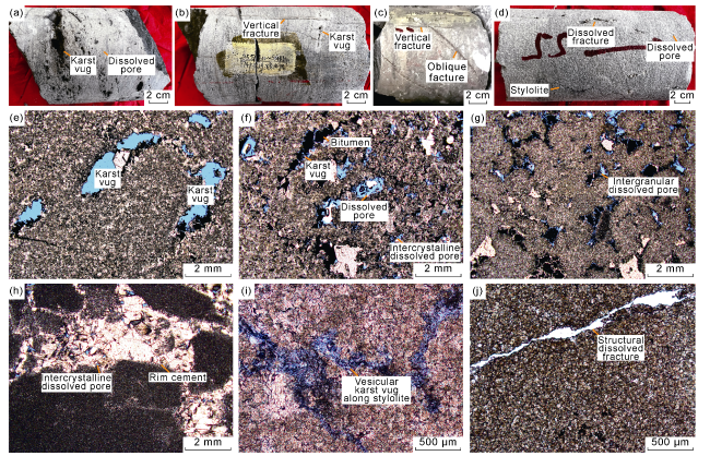
Fig. 12. Reservoir space types of the Xixiangchi Formation in the study area. (a) Light gray arenaceous dolomite with small bedding-parallel karst vugs and dissolved pores, 5 348.40-5 348.50 m, Xi 3 Member, Well GT2, core; (b) light gray arenaceous dolomite with small bedding-parallel karst vugs, dissolved pores and vertical fractures, 5 348.60-5 348.83 m, Xi 3 Member, Well GT2, core; (c) oblique and vertical fractures, 4 618.61-4 618.70 m, Xi 4 Member, Well BL1, core; (d) dissolved fractures, vugs and stylolites, 4 419.48-4 419.63 m, Xi 4 Member, Well LG1, core; (e) fine crystalline dolomite with arenaceous phantoms and small karst vugs, 5 357.34 m, Xi 3 Member, Well GT2, cast thin section, plane polarized light; (f) powdered-fine crystalline dolomite with intercrystalline dissolution pores and small karst vugs, 5 337.27 m, Xi 4 Member, Well GT2, cast thin section, plane polarized light; (g) arenite dolomite with intergranular pores, 5 320.00 m, Xi 4 Member, Well GT2, cast thin section, plane polarized light; (h) karst breccia with residual intercrystalline pores and seafloor rim cements, 4 992.95 m, Xi 4 Member, Well NC7, cast thin section, plane polarized light; (i) fine dolomite with vesicular karst vugs along stylolites, 5 030.29 m, Xi 4 Member, Well NC7, cast thin section, plane polarized light; (j) crystal powder dolomite with dissolved fractures, 4 634.75 m, Xi 4 Member, Well BL1, thin section, plane polarized light. |
On the core of the shoal-controlled reservoir, there are small karst vugs, pores and fractures which are nearly horizontal (Fig. 12a -12d). The microscopic reservoir space is composed of small karst vugs, intergranular and intercrystalline dissolved pores, vesicular dissolved pores and fractures along stylolites (Fig. 12e -12j). Of them, intergranular and intercrystalline dissolved pores are the most developed, while small karst vugs are developed locally in Well GT2 (Fig. 12a ). It is worth noting that intercrystalline pores mainly appear in the powdered-fine crystalline dolomite with residual particle phantoms, indicating that the original rock is grain dolomite. The reservoirs are fractured-vuggy and fractured-porous types [24]. It is concluded that all reservoirs of the Xixiangchi Formation are developed in grain shoals, so they are typical shoal-controlled reservoirs.
3.2.2. Coupling relationship between shoal-controlled reservoirs and multistage slope break belts
Based on the above analysis, it is found that all reservoirs of the Xixiangchi Formation are developed in grain shoals. In order to further identify the relationship between grain shoals and reservoirs, the cumulative thickness of grain shoals and shoal-controlled reservoirs in each well was calculated based on core data and logging interpretation of 82 wells. It’s found that the two types of cumulative thickness are well correlated, and the correlation coefficient is up to 0.96 (Fig. 13 ), indicating that grain shoals are the foundation of reservoir development. The shoals tend to accumulate toward the uplift, so that they are prone to expose to meteoric water leaching, resulting in karst vugs and "facies-controlled" karst reservoirs. In addition, low-angle network fractures are formed associated with karst process, which change largely in width, and are cemented to a high degree (Fig. 7a , 7b).
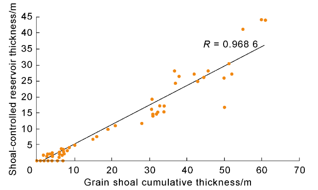
Fig. 13. Cumulative thickness of grain shoals and shoal- controlled reservoir thickness in single wells. |
According to this understanding, combined with the logging interpretation and the abovementioned distribution law of grain shoal thickness, the plane distribution of shoal-controlled reservoir thickness in the third and fourth members of the Xixiangchi Formation was mapped (Fig. 14 ), which shows that the shoal-controlled reservoirs are coupled with the overlap slope break belts, and the reservoirs are mainly developed in the first and second slope break belts. Thicker reservoirs in the second zone are wider than those in the first zone, and the cumulative thickness of the shoal-controlled reservoir can reach 45 m. The results showed that the first and second overlap slope break belts may have been above the wave base for a long time, and are dominated by high-energy grain shoal deposits. Under the influence of high-frequency sea level fluctuation, high-quality reservoirs are formed by exposure and dissolution.
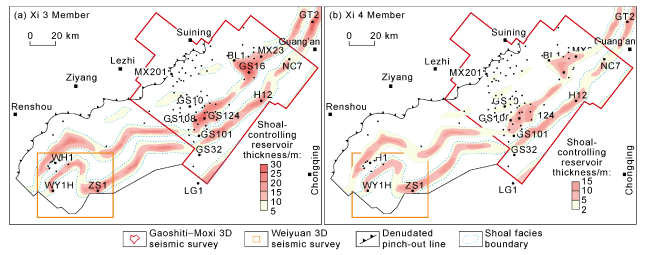
Fig. 14. Thickness distribution of shoal-controlled reservoirs in the Xi 3 Member and Xi 4 Member in the study area. |
4. Discussion
4.1. Formation mechanism of slope break belts, control of slope break belts and shoal-controlled reservoir model
During the transition from the Rodinian supercontinent to the Gondwana supercontinent [25-26], the Kimery micro-continent and the South China Plate were gradually spiced with the Kunnga suture zone to the western margin of the Eastern Gondwana continent in the Cambrian [27]. In the late Early Cambrian, the proto-Tethys oceanic crust subducted along the Sanya Island arc, while the eastern part of the South China Plate was still a passive continental margin [28]. The continuously developing South China rift basin on the South China Plate was filled with carbonate and siliceous clastic rocks (Fig. 15a ). In the Middle-Late Cambrian, the gradual demise of the proto-Tethys Ocean [29-30] resulted in a series of continental convergence and orogeny in the northern margin of the Gondwana continent (490-540 Ma), and the collage of the Central Hainan Block and the Sanya Block in the Ordovician represents the final collage of the South China Plate to the northern margin of the Western Australia (470-490 Ma) in the Early Ordovician [31]. At the same time, although there was no subduction and collision between the Indian Block and the Qiangtang Block connecting with the western margin of the South China Plate, oblique compression caused these blocks to thrust towards the western part of the South China Plate [32]. Simultaneous compressional orogeny on both sides of the South China Plate resulted in large thrust structures, and a paleogeographic pattern of high on both sides and low in the middle (Fig. 15b ). Accordingly, turbidites, argillaceous carbonates in the transition zone, and shallow-water carbonate rocks on the Yangtze platform were successively filled from the Cathysia Block to the Yangtze Block. Therefore, the uplift and depression pattern of the central Sichuan area was more influenced by the extrusion from the west margin of the Yangtze Block, and it’s closely related to the foreland basin formed by the India-Himalaya block thrusting toward the Yangtze Block. From west to east, the intracratonic Aba Depression (foredeep), the central Sichuan paleo-uplift (forebulge) and the eastern backbulge basin were developed successively. The westward small thrust fault terminating at the bottom of the Xixiangchi Formation is a direct response to the foreland extrusion thrust system on the seismic section (Fig. 2 ), reflecting forward thrust extrusion from west to east in the Middle-Late Cambrian. The tectonic transfer process directly resulted in the dramatic change of geomorphology and the formation of slope break belts, and then controlled the paleo-geomorphology of the southern slope of the Leshan-Longnüsi paleo- uplift as multiple slope breaks toward southeast (Fig. 4 ).
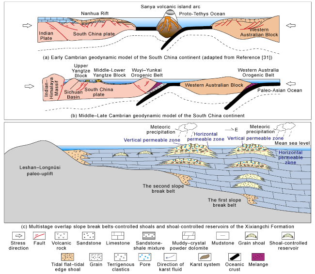
Fig. 15. The geodynamic model of the Cambrian South China continent, and multistage overlap slope break belts controlled shoals and shoals controlled reservoir model. |
The filling model of the Xixiangchi Formation shows a continuous westward overlap, indicating that the basin could accommodate a continuous increase in space. Although the basin was in a compressional tectonic environment at that time, the central Sichuan was in the forebulge and backbulge of the foreland system. Its response to compressional action was weaker than the foreland thrust belt, and the influence on the overall basin pattern was limited. At the same time, the global sea level continued rising in the Middle-Late Cambrian, reaching 30-40 m [33], which provided enough space for the deposition of the Xixiangchi Formation and offset the limited uplift of the basin caused by compression.
The terrigenous mixture around the paleo-uplift (Fig. 7k , 7l) indicates a shallow water environment. Together with the progressive overlap model, the paleo-uplift had the characteristics of paleo-continent during the sedimentary period of the Xixiangchi Formation. The present hiatus of strata is not only caused by denudation. After transgression reached the slope break belt, the shoreline had stagnated a long time in the slope break belt, leaving high-energy coastal sand bar deposits near the wave base. The conformal geomorphic characteristics were strengthened due to the higher CaCO3 deposition rate in the high-energy facies zone compared with other environments [34], even rapid deposits near the sea level were leached by meteoric freshwater into a barrier-lagoon-tidal flat system. If the structure stably settled and transgression crossed the slope break belts, the early barrier shoal sedimentary highland can inherit and develop into an intra-platform highland in a long time, and control the later sedimentation (Fig. 15c ).
4.2. Favorable exploration zones
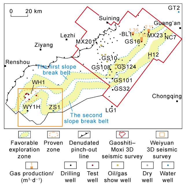
Since 2005, a number of industrial and low-yield gas wells in the Cambrian Xixiangchi Formation were activated in Weiyuan structure in the southwest of the Leshan-Longnüsi paleo-uplift when re-examining old wells, with a cumulative test production capacity of about 129.19×10⁴ m3/d [35]. The results demonstrate a good exploration potential of the Cambrian Xixiangchi Formation in the structure. Later, many wells found large-scale shoal reservoirs in eastern Sichuan Basin, Gaoshiti-Moxi area and Guang’an area [36], and industrial gas flow was obtained in wells PQ1, GS16, BL1, MX23 and NC1. These discoveries indicate that except for the Weiyuan structure, other areas in the Sichuan Basin also have the conditions for oil and gas accumulation. As mentioned above, the Xixiangchi Formation is characterized by the development of shoal-controlled reservoirs, and the distribution and size of the grain shoals are important indicators for exploration benefits. The shoal-controlled reservoirs are strongly heterogeneous, and oil and gas migration and accumulation are controlled by lithology in the structural setting, with mainly structure-lithology composite trap [37]. This study analyzed the process of shallow-water overlap deposition and the pattern of slope break belt-controlling shoals and grain shoal-controlling reservoirs, and estimated the two favorable zones and their sizes of shoal-controlled reservoirs. Therefore, combined with the oil and gas test results, it is believed that the grain shoals in the first and second overlap slope break belts are favorable lithologic reservoirs to be explored in the future. With an area of 3 340 km2 and a thickness of the shoal-controlled reservoir generally greater than 20 m, this area is suggested to be the key area for large-scale shoal exploration in the Xixiangchi Formation in the next step, with a view to achieving greater breakthroughs and discoveries in this field (Fig. 16 ).
Fig. 16. Favorable exploration zones of the Cambrian Xixiangchi Formation in the study area. |
5. Conclusions
The Xixiangchi Formation is filled with a typical "bottom overlap and top truncation" shallow water overlap sedimentary model, which is featured by multistage slope breaks and dipping toward southeast. Combined with the lithological-electrical characteristics, the inner strata of Xixiangchi Formation are divided into 4 members upwardly. Some lower strata are missing from the overlap slope break belt toward the paleo-uplift.
The grain shoals of the Xixiangchi Formation are mainly composed of sandy dolomite and powdered-fine crystal dolomite with particle phantoms, which are thin (thinner than 1 m generally) and frequently superimposed. The lithology is mainly grain dolomite and crystallized grain dolomite. The reservoir space is almost contributed by intergranular and intercrystalline dissolved pores, and a few small karst vugs and fractures. Vertically, the superimposed grain shoals and the shoal-controlled reservoirs are developed in the Xi 3 Member and the Xi 4 Member, and laterally distributed as stripes around the first and the second overlap slope break belts.
In the Middle-Late Cambrian, as the South China Plate and the Rodinia supercontinent converged, the western margin of the South China Plate interacted with the Qiangtang-Himalaya massif, and resulted in a NW-SE compressive stress that continuously compressed the Sichuan Basin and caused westward thrust faults, which further influenced the formation of multistage slope breaks. The following continuous transgression let the shoreline stagnate a long time near the slope breaks, which facilitated the development of hierarchic shoal barriers and geomorphic highs. In addition, in the late stage of the highstand tract of the high-frequency sedimentary cycle, these zones were vulnerable to the leaching of atmospheric fresh water, leaving shoal-controlled karst reservoirs.