

Introduction
Hot dry rock (HDR) is a kind of rock mass with no or only a few of fluid inside, with temperature higher than 180 °C and thermal energy to be exploited and utilized under the existing technological and economical conditions [1]. The thermal energy reserves of HDRs are quite rich, with those at a depth of 3-10 km inside the earth being equivalent to nearly 30 times of total coal, oil and gas reserves [2]. In the current context of energy security and global climate change, HDR has received concerns from more and more countries due to its characteristics such as enormous resources, stable energy supply, clean-liness and safety [3-4].
There are about 42 HDR projects in operation all over the world, which are mainly distributed in the Eurasian plate, the India-Australian plate, the margin of the East Pacific divergence and convergence plate, the margin of the Western Pacific convergence plate, and the volcanic island arc area of the Caribbean Sea [2,5]. The modern concept of hot dry rock was proposed by the Los Alamos Laboratory of the United States in 1974, and the first pilot project was carried out in the Fenton Hill of New Mexico, which verified the possibility of developing geothermal energy from HDRs [6-7]. Japan started an experimental study on HDR in 1984, and the Hijiori project has achieved long-term production of large-scale energy [8]. French Soultz-sous-Forêts project started in 1992, and still has 3 production wells at present [9-10]. In 2002, the Australian Habanero project achieved the operation of 1 MW power plant [1⇓⇓⇓⇓⇓⇓⇓⇓⇓⇓⇓-13]. In 2010, the United States Department of Energy implemented the globally largest HDR development project -FORGE (Frontier Observatory for Research in Geothermal Energy) [14]. Additionally, England, Germany, Switzerland, and Korea have implemented field test projects of HDR [15-16]. All these projects show the huge exploration and development potential of geothermal resources in HDRs, indicating they are one of the important new replacement energies in the future.
China is rich in HDR geothermal resources. The existing data show that the total quantity of HDR geothermal resources at the depth of 3-10 km in the land areas is 2.09×1025 J, equivalent to 715×1012 t standard coal [17]. In addition, the increase in the proportion of geothermal energy utilization by 1% is equivalent to 9 400×104 t CO2 emission reduction, which is favorable for the achievement of the “dual-carbon” goals [18-19]. Based on genesis mechanisms and occurrence conditions, HDR geothermal resources can be classified into four types: high heat flow granite, plate tectonic activity zone, sedimentary basin, and modern volcano [20-21]. In 2013, China began nationwide potential evaluation and demonstration area study of HDRs [3,14,20]. On this basis, some scholars carried out evaluations on the prospects of HDR. He et al. [22] classified the factors controlling the engineering development of HDR resources into geological resource conditions, engineering technology conditions, and economic market conditions, and adopted the geometric method to evaluate the HDR prospects. Jia et al. [23] applied the magnetotelluric profiles to determine the depth of the magma chamber, and identified the HDR prospects in the Lancai hot spring area of the Gonghe Basin in Qinghai Province. Yu et al. [24] comprehensively evaluated the HDR prospects in Liaoning Province on a large scale based on heat flow, Curie depth, distribution characteristics of acidic rock masses, depth of magma chamber, characteristics of tectonic stress field, etc. Yang et al. [25] comprehensively and qualitatively evaluated the HDR prospects in the Jiyang Depression from the aspects of Curie depth, Moho depth, geothermal gradient, thermal reservoir lithology, cap rock thickness, and buried hill scale. Zhang et al. [26] analyzed the structural characteristics, Curie depth, and surface temperature anomalies in the Longnan-Shicheng area of Jiangxi Province using the magnetotelluric method and the remote sensing technique, and predicted the HDR prospects qualitatively. Liu et al. [27] divided the HDR prospects in the Lower Liaohe Basin by analyzing geothermal gradient, deep geothermal temperature, and rock thermal conductivity. Yan et al. [28] predicted the HDR prospects in the Guide Basin of Qinghai Province by comprehensively analyzing surface high-temperature anomaly zones, regional gravity anomalies, regional aeromagnetic anomalies, and electromagnetic exploration data.
It is indicated that scholars employ different evaluation methods and parameters for the selection of HDR targets. Their efforts are more qualitative than quantitative, and rely on fewer evaluation indicators, which restricts the further promotion of HDR area evaluation and HDR industry in China. This paper systematically investigated the geological characteristics of HDRs around the world. Then, the geological setting and main controlling factors for the formation of HDRs were analyzed. Coupling with the fuzzy analytic hierarchy process (FAHP), a systematic evaluation method for HDR prospects was proposed. This method was applied to evaluate the HDR resources in the central Inner Mongolia. The research results provide a new approach and scientific basis for the evaluation, exploration and development of HDR prospects in China.
1. HDR evaluation approach
Evaluation of HDR prospects requires a knowledge of their genesis elements, so as to yield a result approaching the real underground situations. Firstly, the key elements for the formation of HDR are identified. Then, the characteristic geological conditions that influence or indicate the key elements are determined. Finally, a hierarchical comprehensive evaluation system is established to quantitatively or semi-quantitatively evaluate the HDR prospects [29⇓-31].
The formation of HDRs is usually under the joint control of four key elements: heat source, channel, reservoir, and cap rock. So, the evaluation of HDR prospects focuses on the four elements. The heat source is influenced by Moho depth, Curie depth, and depth of molten mass or magma chamber, and it can be indicated clearly by time of magmatic/volcanic activity, heat flow, geothermal gradient, and surface thermal anomaly. The channel is closely related to the distribution of discordogenic faults, earthquake magnitude, and focal depth. The burial depth of reservoir determines the economy and recoverability of HDR resources. The lithology and thickness of cap rock are crucial for the preservation of the heat in HDRs (Fig. 1 ).
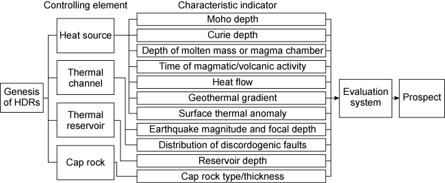
Fig. 1. Approach of HDR prospect evaluation and flow chart. |
2. Evaluation indicators and method
2.1. Evaluation indicators and criteria
An evaluation system has been established based on the genetic mechanisms and distribution patterns of HDR resources currently known worldwide. The selection of evaluation indicators can be further refined based on advancements in geological understanding and the availability of data (Table 1 ). The values for the evaluation criteria at all three levels in this study are derived from practical experience or theoretical analysis, informed by comprehensive research and assessment of current theoretical understanding as well as exploration and development practices. These values align with the characteristics of most known HDR systems. As research knowledge, engineering technologies, and practical applications evolve, these values may change. The system can be adjusted for the evaluation of specific projects.
Table 1. Evaluation indicators for HDR prospects |
| Evaluation element (U) | Evaluation indicator (u) | Indication | Evaluation criteria | Level (V) |
|---|---|---|---|---|
| Heat source (U1) | Moho depth (u1) | It indicates that the deep heat source (mantle sourced heat) is close to the surface, which is conducive to the upward conduction of deep heat. | <30 km | I |
| 30-45 km | II | |||
| >45 km | III | |||
| Curie depth (u2) | It indicates the deep temperature field and stress field. | <26 km | I | |
| 26-40 km | II | |||
| >40 km | III | |||
| Depth of molten mass or magma chamber (u3) | It indicates the existence of high-temperature heat source and its contribution. | ≤10 km | I | |
| >10 km | II | |||
| No | III | |||
| Time of magmatic/volcanic activity (u4) | It indicates the existence and effectiveness of underground heat source. | After the Cenozoic Era | I | |
| Mesozoic era | II | |||
| Before the Mesozoic Era | III | |||
| Heat flow (u5) | It indicates the existence of thermal anomaly zone underground. | >80 mW/m2 | I | |
| 60-80 mW/m2 | II | |||
| <60 mW/m2 | III | |||
| Geothermal gradient (u6) | It indicates the existence of high-temperature anomaly zone underground. | >60 °C/km | I | |
| 30-60 °C/km | II | |||
| <30 °C/km | III | |||
| Surface thermal anomaly (u7) | It is usually in a paragenic relation with deep high-temperature rock masses, and indicates thermal anomaly underground. | Dense distribution of volcanoes and hot springs | I | |
| Presence of volcanoes and hot springs | II | |||
| No obvious volcanoes and hot springs | III | |||
| Thermal channel (U2) | Earthquake magnitude and focal depth (u8) | The accumulation of heat energy breaks the balance state inside the earth. | Magnitude ≥3, and focal depth <15 km, | I |
| Magnitude ≥3, and focal depth ≥15 km | II | |||
| Magnitude <3 | III | |||
| Distribution of discordogenic faults (u9) | Discordogenic fault is the main channel for the ascending of deep magma, and its distribution indicates the presence of high-temperature rock masses in the shallow part. | Direct communication with molten mass or magma chamber | I | |
| Indirect communication with molten mass or magma chamber | II | |||
| Absence or no communication | III | |||
| Thermal reservoir (U3) | Reservoir depth (u10) | It indicates the availability of underground high-temperature resources, and determines whether it is HDR resource. | <5 km | I |
| 5-8 km | II | |||
| >8 km | III | |||
| Cap rock (U4) | Type/thickness of cap rock (u11) | The cap rocks with low thermal conductivity can effectively prevent heat loss and indicate the preservation of high-temperature resources underground. | Sedimentary rock with thickness ˃1 km | I |
| Sedimentary rock with thickness <1 km | II | |||
| Other rock types | III |
2.1.1. Heat source
2.1.1.1. Moho depth
Moho discontinuity is the boundary between crust and mantle. Its distinguishing characteristic is a significant change in seismic wave velocity at this interface and its uplifted features indicate the uplift movement of deep mantle diapers and mantle thermal materials. The depth of Moho discontinuity (or Moho depth) on land averages 33 km. It is small in basin areas and large in orogenic belt areas such as the Qinghai-Tibet Plateau. Globally, the Moho discontinuity exhibits uneven features of local uplift and local depression. The shallow Moho discontinuity indicates that the deep heat source (mantle-sourced heat) is close to the surface, which is conducive to the upward conduction of deep heat to provide favorable conditions for the formation of HDR resources. The Moho depth is an important indicator for evaluating the HDR prospect. The depth of the Moho discontinuity in global HDR demonstration development areas is generally less than 30 km. For example, Iceland, located in the spreading belt of the mid-Atlantic ridge, has a thin crust and rich high-temperature geothermal resources, with the Moho depth ranging from 10 km to 20 km. In the Taupo Volcanic area of New Zealand, the Moho depth is between 20 km and 30 km. The Soultz HDR project in France, a leading demonstration of an enhanced geothermal system (EGS), operates at a depth of approximately 25 km on the Moho. In China, the Moho depths in the Weihe and Songliao basins range from 30 km to 45 km, with geothermal gradients and ground heat flow values at medium levels. These basins contain some HDR resources, though they are not comparable to the high-quality resources found in typical demonstration areas. When the Moho depth exceeds 45 km, the deep mantle heat source is too far from the surface, hindering upward heat transfer and making it difficult to form high-quality HDR resources through lithospheric conduction under normal conditions. For example, in the western US, there are essentially no HDR projects where the Moho depth exceeds 45 km [32]. However, geothermal energy can still accumulate in the presence of deep heat sources (such as mantle-derived heat) or magma pockets connected by deep faults, as seen in the Gonghe Basin of Qinghai, China. Based on exploration experience and theoretical analysis, the Moho depth can generally be classified into three levels: I (less than 30 km), II (30-45 km), and III (greater than 45 km).
2.1.1.2. Curie depth
Curie point isotherm is a temperature interface where magnetic minerals in rocks get demagnetized. It indicates the distribution of the underground temperature field, and also the thermal stress field in the deep crust. A small depth of Curie point isotherm (or Curie depth) indicates that there is more heat in the deep part and the heat can quickly conduct upwards in a large quantity. Thus, the Curie depth is an important indicator for evaluating HDR prospects.
There are significant variations in the Curie depth across the globe. The Ukrainian Shield has the deepest Curie depth, ranging from 55 km to 120 km, while Yellowstone National Park in the US has the shallowest, with Curie depths of only 5 km to 6 km. In mainland China, the Curie depth generally ranges from 20 km to 38 km. The western US hosts the largest concentration of HDR development projects in the world, with most areas located at Curie depths of less than 10 km [33]. Some regions of Iceland have high-temperature geothermal development at Curies depths of less than 10 km [34]. The Rhine Graben, which includes locations like Soultz in France and Landau in Germany, has a Curie depth of 15 km to 18 km [35]. Most of the hot springs in the Chinese mainland are located in areas with a Curie depth of less than 26 km, and very few are located in areas with a Curie depth of more than 40 km [36]. The Gonghe Basin and its surrounding areas in Qinghai Province have a Curie depth ranging from 16 km to 26 km [37]. A Curie depth of less than 26 km is favorable for the formation of HDR resources [38], while Curie depths greater than 40 km hinder their formation. Based on existing research, the Curie depth index is categorized into three levels: I (less than 26 km), II (26-40 km), and III (greater than 40 km) [39].
2.1.1.3. Depth of molten mass or magma chamber
As the mantle heat flow rises, it has a substance and energy exchange with the crustal rock. This process often forms an extensive ductile rheological layer in the lower crust, or molten mass or magma chamber under appropriate conditions. As the mantle, crust-mantle mixture, or lower crustal fluids continue to propagate upwards, thermal energy accumulates again in the ductile rheological layer of the middle crust. Local molten or semi-molten components may exist in certain parts of the middle-upper crust. At appropriate depths, these molten masses or magma chambers can serve as effective heat sources for HDR resources [40]. Partial melts or magma chambers distributed in relatively shallow depths can quickly heat the overlying HDR. In Iceland’s volcanic active areas, magma chambers are located 2 km to 5 km deep, and the region boasts highly developed high-temperature geothermal resources. The FORGE project in the US suggests the presence of partial melts below 10 km, which promotes the formation of HDR resources [41]. Based on this, depths of partial melts or magma chambers are classified into three grades: I (less than and equal to 10 km), II (greater than 10 km), and III (no deep molten mass or magma chamber). Under current technological conditions, it is believed that drilling can reach depths of up to 10 km, making the utilization of HDR resources formed by partial melts or magma chambers within this depth technically feasible. However, beyond this depth, these resources cannot be effectively utilized.
2.1.1.4. Time of magmatic/volcanic activity
Time of magmatic/volcanic activity indicates the time at which high temperature occurs near the surface. Modern volcanism and magmatism are often closely related to geothermal anomalies. The heat generated by magma intrusion and eruption before the Cenozoic has disappeared completely, and only the uncondensed volcanic remnants and magma intrusions are left to provide heat sources for anomalous areas, so the magma intrusion and volcanic eruption during the Miocene to Quaternary are more significant for the formation of geothermal areas [42]. If volcanic activity occurred before the Miocene, it is generally believed that the magma has since cooled, making the formation of high-quality HDR resources difficult. In the area surrounding the HDR site at Fenton Hill in the US, volcanic activity has been frequent since 13 Ma, with the most recent eruption occurring 0.13 Ma [43]. The main HDR body in the FORGE Project in the US is primarily composed of granites that have been intruded since the Neogene. Intense magmatic activity occurred during the Mesozoic era, and although the upper crust has fully cooled, the partial melt may still exist in the middle and lower crust, as seen in the Songliao Basin[44]. Therefore, using the timing of magma and volcanic activity as a key index, taking the Cenozoic and Mesozoic eras as time nodes, it is divided into three levels: I (after the Cenozoic era), II (Mesozoic era), and III (before the Mesozoic era).
2.1.1.5. Heat flow
Heat flow anomaly can intuitively reflect the existence of high-temperature underground rock masses. In this respect, the heat flow density is a comprehensive thermal parameter of the geothermal field, and it can reflect the characteristics of the geothermal field within a region more accurately than the other parameters such as temperature and geothermal gradient [38]. The average heat flow globally is usually 60-80 mW/m2. A heat flow reach or over 80 mW/m2 in an area indicates the possible existence of high-temperature rock mass in the deep part. Based on the global heat flow distribution map compiled by previous researchers, it is evident that heat flow in the four high-temperature geothermal regions exceeds 100 mW/m2 [45]. Typical HDR fields, such as FORGE, reach 120 mW/m2 [46], while Soultz exceeds 140 mW/m2 [47], and the average heat flow in the Gonghe Basin of China is 102 mW/m2 [48]. If the heat flow is below 60 mW/m2, it indicates that the heat flow in the region is lower than the global average, suggesting the absence of underground heat anomalies. Therefore, The indicator of heat flow is classified into three levels: I (greater than 80 mW/m2), II (60-80 mW/m2), and III (less than 60 mW/m2).
2.1.1.6. Geothermal gradient
A high geothermal gradient indicates that the geothermal temperature in the deep underground increases rapidly as the depth increases, and the rock masses with high temperature may develop in the relatively shallow part. Therefore, the high geothermal gradient anomaly is an important indicator for HDR prospect. Generally, the geothermal gradient in continental areas is around 30°C/km. If the geothermal gradient in a specific area exceeds this value, it indicates the presence of a thermal anomaly. For example, the geothermal gradient of the overlying sedimentary cover in the Soultz area of France exceeds 100 °C/km [49], while the geothermal gradient of the sedimentary cover in Habanero, Australia, is close to 60 °C/km [50]. In the Qinghai-Tibet Plateau and Gonghe Basin in Qinghai Province, China, the geothermal gradient reaches as high as 60-70°C/km. The experimental development of HDR has been successfully conducted in these two areas, suggesting that high-quality HDR resources typically have a geothermal gradient greater than 60 °C/km. Therefore, this indicator is classified into three levels: I (greater than 60 °C/km), II (30-60 °C/km), and III (less than 30 °C/km). It is usually in a close relationship with the heat flow value, and can be used according to the data availability.
2.1.1.7. Surface thermal anomaly
Abnormal thermal background and tectonic activity intensity control the density and distribution of surface thermal anomalies. The areas with surface thermal anomalies such as hot springs and volcanoes are usually in a paragenic relation with deep thermal anomalies, so it is more probability to discover HDR resources in deep areas. This is a conventional approach to searching for dry heat based on water heat [51]. There is a correlation between the distribution of hot springs and the deep thermal background, including factors such as the thermal lithospheric thickness, the Moho depth, and the Curie depth [33]. The formation of hot springs is closely linked to heat flow, topography, volcanism, and extensional tectonics [52]. A dense distribution of volcanoes or hot springs in a particular area suggests the presence of a deep thermal anomaly with great probability. Therefore, the degree of abnormal surface heat development is qualitatively classified into three levels: I (dense distribution of volcanoes and hot springs), II (presence of volcanoes and hot springs), and III (absence of obvious volcanoes and hot springs).
2.1.2. Thermal channel
2.1.2.1. Earthquake magnitude and focal depth
Earthquake is a manifestation that the thermal energy accumulated inside the earth breaks the internal balance of the earth. The distribution of high heat anomaly areas and strong earthquakes (high-density earthquakes) globally show the characteristics of extremely high spatial consistency [38]. The intensive occurrence of M3-5 earthquakes in the East African Rift Valley, Fen-Wei Graben, and Dangxiong Yangbajing Graben, along with the frequent occurrence of M3+ earthquakes, is one of the key indicators of the possible development of HDR. Additionally, since seismic activity reflects the accumulation of heat energy, the focal depth is closely linked to the depth of this heat energy accumulation. It is generally considered that a focal depth of less than 15 km is a favorable condition for the development of HDR resources [38]. According to the earthquake magnitude and focal depth, this indicator is classified into three levels: I (magnitude equal to and greater than 3, and focal depth less than 15 km), II (magnitude equal to and greater than 3, and focal depth equal to and greater than 15 km), and III (magnitude less than 3).
2.1.2.2. Distribution of discordogenic faults
The discordogenic fault that penetrates the mantle is one of the main fluid channels within the earth's continental lithosphere and is usually in close relationship with plate activity. It is the structural damage surface deeply cutting into the lithospheric mantle, asthenosphere, and deep crust. The deeper the fault, the more likely it is to cause uplift of the surrounding lithosphere and Moho discontinuity, triggering upwelling of molten substance from the lithospheric mantle and forming a stronger heat flow field. Discordogenic fault is the main channel for the upwelling of deep-seated mantle derived thermal materials, and the upwelling of mantle derived thermal materials can promote the activation of discordogenic fault or the formation of new faults. Partial melting has occurred in both the middle and lower crust of the Tibetan Plateau, closely associated with the presence of deep major faults [53⇓-55]. To some extent, these deep faults serve as indicators of the existence of high-quality HDR resources. Depending on the communication of discordogenic fault with molten mass or magma chamber, this indicator is classified into three levels: I (the presence of discordogenic fault that directly communicates with molten mass or magma chamber), II (the presence of discordogenic fault that indirectly communicates with molten mass or magma chamber), and III (the presence of discordogenic fault that does not communicate with molten mass or magma chamber, or the absence of discordogenic fault).
2.1.3. Thermal reservoir
The utilization of the heat in the high-temperature rocks (higher than 180 °C) without or with only a small quantity of fluid requires appropriate burial depth, which is conducive to the reduction of development difficulty and costs, and the improvement of economic benefits. The shallower the reservoir, the easier it is to achieve commercial development. Based on the current status of drilling, exploitation, and utilization of HDR resources both domestically and internationally, a burial depth of less than 5 km is considered the most economical threshold [56]. In contrast, a heat storage depth of 8 km is generally regarded as less favorable in terms of engineering and economic viability. The indicator of reservoir depth is classified into three levels: I (shallower than 5 km), II (5-8 km), and III (deeper than 8 km).
2.1.4. Cap rock
The preservation of the heat in HDRs is related to the conditions of the overlying cap rocks. The cap rocks with a certain thickness can effectively preserve heat and avoid rapid heat loss. The lithological composition, thermal conductivity, thickness, and water content of cap rocks directly affect their insulation effect. The clastic sedimentary rocks with low thermal conductivity and low water content such as glutenite, sandstone, and mudstone, along with loose sediments including clay, gravel, and sand, can serve as the cap rocks. The successful HDR projects all over the world demonstrate the cap rock thickness greater than 1 km, such as the Soultz of France (1.12 km), the Habanero Basin of eastern Australia (1.78 km), and the Gonghe Basin of Qinghai (1.35 km) [9,57]. When evaluating the conditions of HDR coverage, lithology should be considered first, followed by the thickness of the cover layer. In the typical areas rich in HDR resources mentioned above, the thickness of the cover layer exceeds 1 km.Depending on the lithology and thickness of cap rock, this indicator is classified into three levels: I (sedimentary rocks, thicker than 1 km), II (sedimentary rocks, equal to and less than 1 km thick), and III (other rock types).
2.2. Evaluation method
The fuzzy analytic hierarchy process (FAHP), proposed by T.L. Saaty, an American professor of operational research, is a systematic analysis approach that combines qualitative and quantitative methods. It can handle decision-making problems with uncertainty and ambiguity [58]. By decomposing the problem into different levels, it employs multiple indicators to comprehensively evaluate the objects. Multiple indicators are quantified and assigned with corresponding weights to determine a comprehensive value that can reflect the integrity of the evaluated indicators. The factors controlling the enrichment of HDR resources are complex, corresponding to some evaluation indicators being quantitative while others being qualitative, presenting an ambiguity. Therefore, the FAHP is suitable for evaluating the HDR prospects. In actual applications, due to the varying availability of data in different regions, the FAHP can be adopted to flexibly determine the weights of indicators for purpose of evaluation.
2.2.1. Evaluation data set
An evaluation data set is established according to the HDR prospect evaluation system. In this study, the data set is divided into two types, i.e., evaluation element (U) and evaluation indicator (u).
$U=\left\{ {{U}_{1}},{{U}_{2}},{{U}_{3}},{{U}_{4}} \right\}\text{ }$
$u=\left\{ {{u}_{1}},{{u}_{2}},\cdots,{{u}_{11}} \right\}\text{ }$
2.2.2. Weights of indicators
Based on the evaluation indicator set, an indicator weight judgment matrix is established by using the analytic hierarchy process (AHP). A scale ranging from 1 to 9 is employed to compare and score the relative importance between two elements of each indicator at the same level and membership. Higher scale value represents greater importance of the indicator (Table 2 ).
Table 2. Scale division of relative importance of indicator |
| Scale | Implication (${{a}_{ij}}$ is the comparison scale for elements i and j) |
|---|---|
| 9 | According to comparison of two indicators, i is absolutely more important than j |
| 7 | According to comparison of two indicators, i is significantly more important than j |
| 5 | According to comparison of two indicators, i is much more important than j |
| 3 | According to comparison of two indicators, i is slightly more important than j |
| 1 | According to comparison of two indicators, i is as important as j |
| 2, 4, 6, 8 | Mean judged from two neighboring values |
| Reciprocal | If the importance ratio of i to j is ${{a}_{ij}}$, the importance ratio of j to i is ${{a}_{ji}}=1/{{a}_{ij}}$ |
The normalized weight vector is obtained by calculating the maximum latent root of weight judgement matrix and the corresponding latent vector. The weight judgment matrix needs to be checked for consistency.
This step is repeated to calculate the weight vectors of U elements and u indicators. Then, the weights of u indicators are multiplied with the corresponding weights of U elements to obtain a composite weight vector:
$W=\left( {{w}_{1}},{{w}_{2}},...,{{w}_{11}} \right)\text{ }$
2.2.3. Indicator judgement matrix
Each of the indicators is classified into three levels (I, II, and III), and a comment set V is constituted. The comment set V corresponds to the levels of the HDR prospect evaluation system (Table 1 ).
$V=\left\{ {{V}_{1}},{{V}_{2}},{{V}_{3}} \right\}$
The membership function is determined by:
${{A}_{\text{l}}}(x)=\left\{ \begin{align} & 1\text{ }x\le {{a}_{1}}\text{ } \\ & \frac{{{a}_{2}}-x}{{{a}_{2}}-{{a}_{1}}}\text{ }{{a}_{1}}\text{}x\text{}{{a}_{2}} \\ & 0\text{ }x\ge {{a}_{2}}\text{ } \\ \end{align} \right.$
${{A}_{\text{m}}}(x)=\left\{ \begin{align} & 0\text{ }x\le {{a}_{1}},x\ge {{a}_{3}}\text{ } \\ & \frac{x-{{a}_{1}}}{{{a}_{2}}-{{a}_{1}}}\text{ }{{a}_{1}}<x\le {{a}_{2}} \\ & \frac{{{a}_{3}}-x}{{{a}_{3}}-{{a}_{2}}}\text{ }{{a}_{2}}<x<{{a}_{3}}\text{ } \\ \end{align} \right.$
${{A}_{\text{h}}}(x)=\left\{ \begin{align} & 0\text{ }x\le {{a}_{1}}\text{ } \\ & \frac{x-{{a}_{1}}}{{{a}_{2}}-{{a}_{2}}}\text{ }{{a}_{1}}<x<{{a}_{2}}\text{ } \\ & 1\text{ }x\ge {{a}_{2}}\text{ } \\ \end{align} \right.$
Based on the comment set (grading threshold) and the membership function (Table 1 , Eqs. (5)-(7)), the degree of membership to each evaluation level is calculated, that is, the degree of conformity between the actual state of the evaluation indicator and the evaluation level is determined, with 1 for conformity and 0 for unconformity. Thus, an indicator evaluation matrix is established as follows:
$R=\left[ \begin{matrix} {{r}_{1,1}} & {{r}_{1,2}} & {{r}_{1,3}} \\ {{r}_{2,1}} & {{r}_{2,2}} & {{r}_{2,3}} \\ \vdots & \vdots & \vdots \\ {{r}_{11,1}} & {{r}_{11,2}} & {{r}_{11,3}} \\\end{matrix} \right]$
2.2.4. Comprehensive evaluation
The composite weight vector W is multiplied with the indicator evaluation matrix R to obtain the composite evaluation vector B for each object:
$B=WR=\left( {{w}_{1}},{{w}_{2}},\cdots,{{w}_{11}} \right)\left[ \begin{matrix} {{r}_{1,1}} & {{r}_{1,2}} & {{r}_{1,3}} \\ {{r}_{2,1}} & {{r}_{2,2}} & {{r}_{2,3}} \\ \vdots & \vdots & \vdots \\ {{r}_{11,1}} & {{r}_{11,2}} & {{r}_{11,3}} \\\end{matrix} \right]=\left( {{b}_{1}},{{b}_{2}}\text{,}{{b}_{3}} \right)$
where ${{b}_{i}}$ represents the possibility of the corresponding region being evaluated as level Vj, while taking into account all indicators. The composite evaluation score of each object is:
$D=B{{C}^{T}}=\left( {{b}_{1}},{{b}_{2}},{{b}_{3}} \right){{[\begin{matrix} 9 & 6 & 3 \\\end{matrix}]}^{T}}$
where CT is the grading score matrix, with the scores corresponding to levels I, II, and III, respectively, being ${{[\begin{matrix} 9 & 6 & 3 \\\end{matrix}]}^{T}}$. The objects are ranked depending on D values.
3. Evaluation on the favorable areas of HDR in central Inner Mongolia
The central Inner Mongolia is located in the convergence area of the North China Plate and the Siberian Plate, where the tectonic activity is intense. The Cenozoic volcanic rocks are exposed extensively, and mainly distributed in the Jining volcanic rock area, Abaga volcanic rock area, and Chifeng volcanic rock area [59]. The types of eruptive rocks in the study area and the analysis of field geological survey data indicate that the Cenozoic magmatic activity in this area is extensive and is mainly composed of basic basaltic rocks, whose corresponding intrusive rock masses underground are mainly diabase and gabbro. Mineralogical characteristics indicate that they are the products of rapidly rising mantle derived magma and have a low hybrid degree with the crust [60].
3.1. Determination of indicator weights
The HDR resources in the central Inner Mongolia are evaluated by using the above-mentioned method. This evaluation region covers Xilin Gol League, Chifeng City and the surrounding areas, with a total area of about 29×104 km2 (Fig. 2 ). There is lack of detailed data of geothermal gradient, Moho depth, Curie depth, earthquake magnitude and focal depth for this region. For this evaluation, 7 indicators are selected from Table 1 , including depth of molten mass or magma chamber, time of magmatic/volcanic activity, heat flow, surface thermal anomaly, distribution of discordogenic faults, reservoir depth, and cap rock type/thickness. Based on the study of the geological properties of HDRs in this region and the expert experience method, an indicator judgment matrix is established, and the weight of each indicator is calculated. All of the weights have been checked for consistency (Table 3 ).

Fig. 2. Distribution of fault belts and volcanic rocks in Erlian Basin and its periphery (modified from Reference [61]). |
Table 3. Parameters of indicator weights |
| Controlling element | Elements Weight | Indicator | Indicator Weight | Composite weight |
|---|---|---|---|---|
| Heat source | 0.42 | Moho depth | 0.08 | 0.03 |
| Curie depth | 0.08 | 0.03 | ||
| Depth of molten mass or magma chamber | 0.22 | 0.09 | ||
| Time of magmatic/ volcanic activity | 0.20 | 0.08 | ||
| Heat flow | 0.13 | 0.05 | ||
| Geothermal gradient | 0.13 | 0.05 | ||
| Surface thermal anomaly | 0.16 | 0.07 | ||
| Thermal channel | 0.23 | Earthquake magnitude and focal depth | 0.33 | 0.08 |
| Distribution of discordogenic faults | 0.67 | 0.15 | ||
| Thermal reservoir | 0.23 | Reservoir depth | 1.00 | 0.23 |
| Cap rock | 0.12 | Cap rock type/thickness | 1.00 | 0.12 |
3.2. Evaluation indicators
The magnetotelluric data show that low-resistivity and high-conductivity layers are developed in Xilinhot and Chifeng, indicating the presence of deep molten mass or magma chamber in these two areas. The depth of molten mass or magma chamber is 7-9 km in Xilinhot and 8-10 km in Chifeng [61]. It is determined that the indicator of depth of molten mass or magma chamber is level I in these two areas, and level III in other areas.
During the Eocene to Pleistocene (0.11-36.40 Ma), the central Inner Mongolia experienced intense volcanic and magmatic activities, giving rise to several Cenozoic volcanic groups, including Abaga, Dalinor, and Chifeng. The volcanic activity in this region occurred later, so the preservation conditions are good enough in some areas to keep magma heat. According to the HDR evaluation system, the indicator of time of magmatic/volcanic activity for Abaga volcanic group, Dalinor volcanic group, Chifeng volcanic group and their surrounding areas is level I.
The heat flow is calculated using the oilfield drilling and geothermal drilling data. High values of heat flow are found in Jiergalangtu Sag and Honghaoershute Sag of the Erlian Basin, as well as Hexigten Banner, Ningcheng County and Aohan Banner of the Chifeng Basin. The heat flow in Jiergalangtu Sag and Honghaoershute Sag of the Erlian Basin is in the range of 80-100 mW/m2, with an average of about 87 mW/m2, and that in Reshui Town and Reshuitang Village in the periphery of the Chifeng Basin is 100-140 mW/m2, averaging about 113 mW/m2. All values are higher than the global averages, fully proving the presence of high-temperature HDR resources in this region. The indicator of heat flow is level I for all these areas, and the indicator level for other areas is determined according to Table 1 (Fig. 3 ).
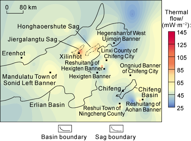
Fig. 3. Distribution of heat flow in Erlian Basin and its periphery. |
There are multiple obvious surface thermal anomalies in the central Inner Mongolia. The reservoir temperature corresponding to the geochemical geothermometer of surface water in the northern Xilinhot is as high as 72.6 °C [62]. The well testing data in Jiergalangtu Sag of the Erlian Basin suggest that the formation temperature at the burial depth of 440 m in Well JH1 is up to 62 °C. There are multiple hot spring spots exposed in Chifeng. The water temperature is up to 80 °C in the geothermal water well KH1 at the burial depth of 200 m in Reshuitang Town of Hexigten Banner in the northwest of Chifeng, 96 °C in the geothermal water well NH1 at the burial depth of 300 m in Reshui Town of Ningcheng County in the southeast, and 90 °C in the geothermal water well AH1 at the burial depth of 700 m in Reshuitang Village of Aohan Banner. All these evidences infer the presence of high-temperature HDR geothermal resources in the deep part of this region. Accordingly, the indicator of surface thermal anomaly is level I in Reshuitang Town of Hexigten Banner and in Reshui Town of Ningcheng County, level II in northern Xilinhot, Jiergalangtu Sag, and Reshuitang Village of Aohan Banner, and level III in other areas.
There are multiple discordogenic faults developed in the central Inner Mongolia, among which, the Erlian-Hegenshan fault zone, Xar Moron fault zone, and Xilinhot fault zone connect the upper crust and upper mantle lithosphere. Secondary faults may indirectly communicate with high-temperature heat sources, so as to have a significant impact on geothermal activity in this region [60]. For example, the Nenjiang-Balihan fault passes through Ningcheng County of Chifeng City, and is located in the southern part of the Huade-Chifeng EW discordogenic fault; the Reshuitang Town of Hexigten Banner is located at Soren Aobao-Ar Horqin Banner discordogenic fault zone; the Reshuitang Village of Aohan Banner is located at the secondary fault zone of the influence zone on the south side of the Huade-Chifeng nearly EW discordogenic fault (Fig. 2 ). Accordingly, the indicator of distribution of discordogenic faults is level I in Ningcheng County, level II in Reshuitang Town of Hexigten Banner and in Reshuitang Village of Aohan Banner, and level III in other areas.
The 180 °C isobath in the central Inner Mongolia which is calculated using drilling data and heat flow data shows that the reservoir depth in Xilinhot is generally greater than that in Chifeng. Some reservoirs in Jiergalangtu Sag are 4-5 km deep, a small number of reservoirs inside Honghaoershute Sag are 4-5 km deep, the reservoirs in Hexigten Banner and Aohan Banner of Chifeng are 2-3 km deep, and those in Ningcheng County of Chifeng are only 1-2 km deep. The indicator of reservoir depth in above mentioned areas is level I, and this indicator for the other areas is determined according to Table 2 (Fig. 4 ).
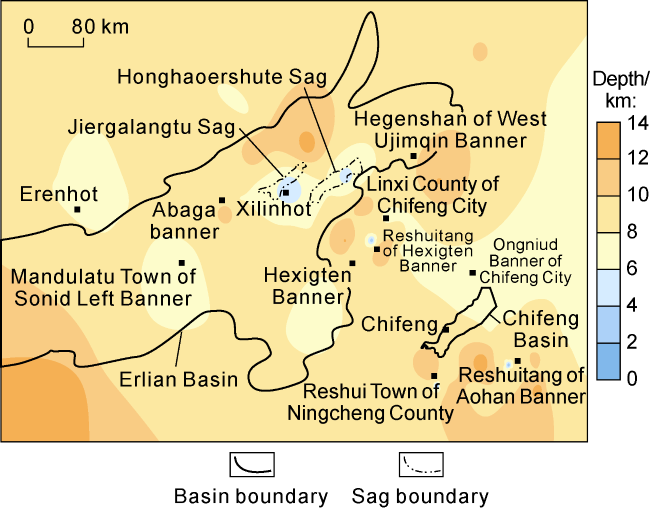
Fig. 4. 180 °C isobath in Erlian Basin and its periphery. |
In the Erlian Basin, the main sedimentary formations are represented by Cretaceous, Neogene, and Quaternary. The Cretaceous is mainly composed of sedimentary rocks such as mudstone and sandstone, and the Quaternary is mainly composed of silty mudstone and clay, with a thickness ranging from 1 400 m to 2 500 m. In the Chifeng Basin, the main sedimentary formations are Cretaceous and Quaternary. The Cretaceous is mainly composed of gray-grayish yellow conglomerate, glutenite and thin bedded mudstone, and the Quaternary is mainly composed of loose sediments such as silty clay and gravel, with a thickness ranging from 700 m to 1300 m. The Cretaceous and Neogene clastic rocks and the Quaternary loose sediments have poor thermal conductivity and good insulation capacity, so they can act as regional cap rocks. Accordingly, the indicator of cap rock type/thickness is level I in the Erlian Basin, level II in the Chifeng Basin, and level III in other areas.
Based on the single-factor analysis above, together with the HDR prospect evaluation system, the comprehensive HDR prospect evaluation is conducted for 10 key areas, including Jiergalangtu Sag and Honghaoershute Sag in the central Inner Mongolia. The comprehensive evaluation result is obtained by multiplying the weight vector with the evaluation matrix constructed depending on the characteristics of evaluation indicators (Table 4 ).
Table 4. Comprehensive evaluation of HDRs in the key areas of Erlian Basin and its periphery |
| Eevaluation area | Adjacent volcano groups | Parameters of indicators | Composite evaluation score (D) | |||||||
|---|---|---|---|---|---|---|---|---|---|---|
| Deep molten mass or magma chamber | Time of magmatic/ volcanic activity | Heat flow/ (mW·m-2) | Surface thermal anomaly | Distribution of discordogenic faults | Reservoir depth/km | Cap rock type/ thickness | ||||
| Jiergalangtu Sag | Abaga volcano group and Dalinor volcano group | Presence of deep molten mass or magma chamber at the depth of 7-9 km | Quaternary | 80-100 | Presence of volcanoes and hot springs | Erlian-Hegenshan fault zone and Xilinhot fault zone directly communicate with molten mass or magma chamber | 4-5 | 1 400-2 100 m thick; mainly mudstone, sandstone and clay | 9.10 | |
| Reshui Town of Ningcheng County | Chifeng volcano group | Presence of deep molten mass or magma chamber at the depth of 8-10 km | Neogene | >100 | Densely distributed volcanoes and hot springs | Chifeng-Bayan Obo fault directly communicates with molten mass or magma chamber | 1-2 | 900-1 300 m thick; mainly glutenite, mudstone and clay | 8.95 | |
| Reshuitang Town of Hexigten Banner | Dalinor volcano group and Chifeng volcano group | Presence of deep molten mass or magma chamber at the depth of 8-10 km | Quaternary and Neogene | >100 | Densely distributed volcanoes and hot springs | Wenduermiao-Xar Moron fault directly communicates with molten mass or magma chamber | 2-3 | 710-850 m thick; mainly glutenite, thin bedded mudstone and loose sediments | 8.90 | |
| Reshuitang Village of Aohan Banner | Chifeng volcano group | Presence of deep molten mass or magma chamber at the depth of 8-10 km | Neogene | >100 | Densely distributed volcanoes and hot springs | Balihan-Nenjiang fault directly communicates with molten mass or magma chamber | 2-3 | 800-1 000 m thick; mainly glutenite, mudstone and clay sand | 8.75 | |
| Honghaoershute Sag | Abaga volcano group and Dalinor volcano group | Presence of deep molten mass or magma chamber at the depth of 7-9 km | Quaternary | 80-90 | Presence of volcanoes and hot springs | Erlian-Hegenshan fault zone and Xilinhot fault zone directly communicate with molten mass or magma chamber | 4-5 | 1 500-2 500 m thick; mainly mudstone, sandstone and clay | 8.45 | |
| Hegenshan of West Ujimqin Banner | No volcanic activity | Presence of deep molten mass or magma chamber at the depth of 10-20 km | 50-60 | Absence of obvious volcanoes and hot springs | Tsagaan Ovoo-Arong Banner fault indirectly communicates with molten mass or magma chamber | >8 | More than 3 km thick; mainly rhyolite, basalt and sandstone | 4.30 | ||
| Mandulatu Town of Sonid Left Banner | Abaga volcano group | Presence of deep molten mass or magma chamber at the depth of 30-50 km | Quaternary | 40-50 | Absence of obvious volcanoes and hot springs | Erlian-Hegenshan fault indirectly communicates with molten mass or magma chamber | >8 | More than 3 km thick; mainly rhyolite, tuff and sandy mudstone | 3.60 | |
| Ongnuid Banner of Chifeng City | Chifeng volcano group | Presence of deep molten mass or magma chamber at the depth of 15-30 km | Neogene | 50-60 | Absence of obvious volcanoes and hot springs | Buried fault indirectly communicates with molten mass or magma chamber | >8 | More than 3 km thick; mainly tuff, andesite and loose sediments | 3.45 | |
| Linxi County of Chifeng City | Chifeng volcano group | Absence of deep molten mass or magma chamber | Neogene | 50-60 | Absence of obvious volcanoes and hot springs | Linxi fault is developed, but doesn’t communicate with molten mass or magma chamber | >8 | More than 3 km thick; mainly sandstone, conglomerate and tuff | 2.95 | |
| Erenhot City | No volcanic activity | Absence of deep molten mass or magma chamber | 50-60 | Absence of obvious volcanoes and hot springs | Hegenshan fault is developed, but doesn’t communicate with molten mass or magma chamber | >8 | More than 3 km thick; mainly andesite, rhyolite and sandy mudstone | 2.80 | ||
3.3. Evaluation results
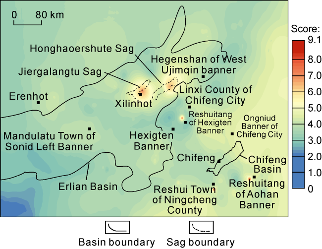
The evaluation results are divided into three categories: a score of 0 to 3 is classified as Grade III, indicating a low probability of HDR resources; a score of 3 to 6 is classified as Grade II, suggesting a potential for HDR resources; and a score of 6 to 10 is classified as Grade I, indicating a higher likelihood of HDR resources. The Grade I areas cover about 494 km2, and the Grade II areas cover about 5.7×10⁴ km2, indicating the existence of abundant HDR resources in the central Inner Mongolia. The Jiergalangtu Sag and Honghaoershute Sag in the Erlian Basin, along with the Reshuitang of Hexigten Banner, Reshui Town of Ningcheng County and Reshuitang of Aohan Banner in Chifeng are determined as Grade I areas for HDR in the central Inner Mongolia (Fig. 5 ).
Fig. 5. Evaluation results of HDR prospects in Erlian Basin and its periphery. |
The evaluation results of HDR prospects in the central Inner Mongolia indicate that the distribution of high-quality HDR resources is controlled by multiple factors under the geotectonic background. Generally, magma or volcanic activity has occurred in such areas since the Cenozoic, so there are still high-temperature molten bodies or magma chambers underground, which provide important heat sources for the formation of HDRs. In addition, the discordogenic fault that directly communicates with molten bodies or magma chambers serves as an efficient channel for heat transfer to the shallow part, thereby continuously transporting heat to the shallow reservoirs. Correspondingly, the thick sedimentary formations overlying the reservoirs provide cap rock conditions for the preservation of heat in the reservoirs. Under the joint influence of these conditions, there are thermal anomalies shown at the surface of such areas or geothermal gradient and heat flow anomaly. To sum up, the establishment of the comprehensive HDR prospect evaluation method and its application in the central Inner Mongolia provide theoretical and methodological support for the selection of other HDR resource exploration and development targets.
4. Conclusions
From the perspective of the main factors controlling the formation of HDRs, the quantitative evaluation system and criteria for HDR prospects are established using the FAHP. This evaluation system mainly consists of four elements: heat source, thermal channel, thermal reservoir, and cap rock, including 11 evaluation parameters, i.e., Moho depth, Curie depth, depth of molten mass or magma chamber, time of magmatic/volcanic activity, heat flow, geothermal gradient, surface thermal anomaly, earthquake magnitude and focal depth, distribution of discordogenic faults, reservoir depth, and cap rock type and thickness. Each parameter is divided into 3 levels.
The application of this evaluation method to the central Inner Mongolia indicates that the Class I HDR prospects cover approximately 494 km2, indicating a higher likelihood of HDR resources, and Class II HDR prospects cover about 5.7×10⁴ km2, suggesting a potential for HDR resources. Specifically, the Jiergalangtu Sag and Honghaoershute Sag in the Erlian Basin, along with Reshuitang Town of Hexigten Banner, Reshui Town of Ningcheng County, and Reshuitang Town of Aohan Banner in Chifeng City, are identified as Class I HDR prospects in the central Inner Mongolia.
The distribution pattern of HDR prospects in the central Inner Mongolia suggests that high-quality HDR resources are usually developed in the areas where magma or volcanic activity has occurred since the Cenozoic, and there are still high-temperature molten bodies or magma chambers underground. In addition, the discordogenic fault that directly communicates with molten bodies or magma chambers serves as an efficient channel for heat transfer to the shallow part, and reservoirs are shallow and overlain by thick sedimentary rocks which provide cap rock conditions.
Nomenclature
Al(x), Am(x), Ah(x)—membership functions of cost type, intermediate type and benefit type;
a1, a2, a3—different thresholds of membership function, corresponding to grading standard;
B—composite evaluation vector;
D—evaluation score;
i, j—serial number of comparison element;
R—indicator judgement matrix;
r—degree of membership determined on the basis of membership function and indicator level;
U—set of controlling elements;
U1, U2, U3, U4—four controlling elements;
u—set of evaluation indicators;
u1 u2, …, u11—11 evaluation indicators;
V—indicator comment set;
W—composite weight vector;
w1, w2, …, w11—weights corresponding to 11 indicators;
x—actual parameter value of evaluation object.