

Introduction
Volcanic reservoirs are widely distributed worldwide. Compared to conventional sedimentary rocks, volcanic reservoirs exhibit favorable reservoir capacities in deep basins [1]. Currently, over 50 countries and regions have discovered volcanic hydrocarbon accumulations or shows in more than 300 basins or blocks globally [2]. In China, volcanic oil and gas exploration entered a rapid development phase from the 1980s, with commercial volcanic reservoirs successively discovered in the Junggar Basin, Songliao Basin, Sichuan Basin and Bohai Bay Basin [3-6]. Mesozoic volcanic rocks are the most widespread buried-hill type in the Bohai Oilfield [7], primarily distributed around the Bozhong Sag, covering an area exceeding 20 000 km2. Located in the central offshore area of the Bohai Bay Basin, the Bozhong Sag is one of the most hydrocarbon-rich sags with well-developed source rocks. Large buried-hill oil and gas fields, such as BZ19-A and BZ26-A, have been discovered around the Bozhong Sag [8-9]. Volcanic rocks around the Bozhong Sag are extensive, resource-rich and underexplored, with promising exploration prospects. However, before 2022, only small oil fields such as LD25-A, JZ20-A, and KL16-A were discovered in Mesozoic volcanic rocks in the offshore Bohai Bay Basin, contributing less than 3% of the proven reserves of buried-hill reservoirs in the offshore Bohai Bay Basin. In December 2022, the Bohai Oilfield achieved a breakthrough by drilling Well BZ8-3S-A in the large Mesozoic volcanic trap BZ8-3S of the Bozhong Sag, yielding a daily production of 170 000 m3 of natural gas and 83 m3 of condensate gas, highlighting the vast potential of volcanic exploration in the Bohai Bay Basin [6].
According to the drilled well data, predecessors have studied the lithological characteristics, formation stages and vertical evolution process of volcanic rocks in the Bohai Bay Basin, especially in areas surrounding the Bozhong Sag [7,10]. These studies divided the lithologies into three vertical eruptive cycles (basic-intermediate- intermediate-acidic) and explored their formation mechanisms. Geological models of volcanic edifice, microfacies classification, reservoir types, characteristics, and controlling factors have also been analyzed [11-13]. Research on reservoir formation mechanisms and development models indicates that high-quality volcanic reservoirs are primarily controlled by lithology, lithofacies, weathering, leaching, tectonic activity and hydrothermal alteration. Hydrocarbon accumulation types and models around the Bozhong Sag provide favorable conditions for hydrocarbon accumulation in intra-source buried-hills [7]. Although previous studies have been conducted on the Mesozoic volcanic rocks in areas surrounding the Bozhong Sag, they mainly focused on the Shijiutuo Uplift and its surrounding areas as well as the southern region where the Tan-Lu strike-slip fault effect is relatively weak. The studies are relatively few which are focus on Mesozoic volcanic rocks in the Bodong Low Uplift and its surrounding areas, where are strongly controlled by the Tan-Lu fault zone. The development mechanism of high-quality volcanic reservoirs controlled by the large Tan-Lu strike- slip fault zone remains unclear and the large-scale hydrocarbon accumulation conditions need further research.
The LK7-A structure in the Bodong Low Uplift in the eastern Bozhong Sag has undergone more than 40 years of exploration without good results. In recent years, based on the newly acquired and processed 3-D seismic data, studies have been carried out on the Mesozoic buried-hill structures and volcanic edifices in the Bodong Low Uplift. Well LK7-A drilled during March to May 2024 has achieved the first breakthrough in the middle-deep layers of the Bodong Low Uplift, obtaining high-yield industrial oil flow, creating the highest daily production record of tested natural gas in the Bohai Sea. Therefore, it is a rare example for studying the large-scale hydrocarbon accumulation of Mesozoic volcanic rocks in the Bohai Sea. Based on the data obtained from the newly drilled wells, in combination with mud logging, well logging, geochemical and lithological-mineral analysis data of the newly drilled wells of Mesozoic volcanic rocks in the Bohai Sea and high-precision 3-D seismic data, this paper studied the distribution law of volcanic rocks, the formation conditions of high-quality reservoirs and the main factors controlling hydrocarbon accumulation in this area. The aim is to establish a large-scale hydrocarbon accumulation model in the Mesozoic volcanic rocks in the Bodong Low Uplift, clarify the potential hydrocarbon accumulation sites and ultimately guide next exploration direction.
1. Regional geological setting
The Bodong Low Uplift in the Bozhong Depression of the Bohai Bay Basin is located in the eastern Bohai Sea, bounded by the eastern and central branches of the Tan-Lu fault zone to the east and west. The Bodong Sag and Bozhong Sag are respectively located at the east and west to the Bodong Low Uplift. It exhibits a horst structure with “two sags sandwiching one uplift”, which is favorable for hydrocarbon migration and accumulation [14-17] (Fig. 1a). The uplift trends nearly north-south and rises from south to north with a shallow saddle dividing it into northern and southern segments. The southern segment (LK7-A buried-hill structure) dips on all sides, forming a favorable anticlinal trap, while the northern segment (LK2-A buried-hill structure) dips east-west and rises northward. Mesozoic volcanic rocks in LK7-A structure show a more advantageous tectonic setting (Fig. 1c). The Bodong Low Uplift underwent multiple tectonic phases [18-19]. During Late Paleozoic, Paleozoic and Proterozoic strata overlaid the Archean basement as stable sedimentary layers. During the Indosinian, collision between the Yangtze and North China plates formed the NE-trending Tan-Lu strike-slip fault. During the Early Yanshanian, NW-trending subduction of the Pacific Plate induced compression, triggering left-lateral strike-slip along the Tan-Lu Fault, leading to fold-uplift deformation and differential erosion of Paleozoic-Proterozoic strata. During the Middle Yanshanian, retreat of the Pacific Plate caused intense rifting. The Tan-Lu Fault, acting as a deep crustal conduit, facilitated magma ascent and large-scale volcanic eruptions, forming thick Mesozoic volcanic sequences. During the Late Yanshanian, renewed Pacific Plate subduction induced regional uplift and erosion of Mesozoic strata. During the Cenozoic, rapid subsidence resulted in the deposition of Paleogene Dongying Formation and Neogene strata directly overlaying the buried-hills.

Fig. 1. Location, stratigraphic column and geological profile of the Bodong Low Uplift. |
Controlled by macroscopic tectonics, the buried-hills in the study area exhibit a stratigraphic sequence from bottom to top: Archean granite and metamorphic rocks, Proterozoic and Paleozoic carbonate rocks, Upper Paleozoic and Mesozoic Jurassic clastic rocks, Mesozoic Yixian Formation volcanic rocks, and Jiufotang Formation clastic rocks. The Jiufotang clastic rocks are primarily distributed in the southeastern part of the buried-hills, while the Yixian volcanic rocks dominate the central part with extensive exposures (Fig. 1b). Overlying the buried- hills, the Paleogene Kongdian Formation to the third member of the Dongying Formation (Es3) are absent. Instead, it is directly overlain by thick mudstones of the second and first members of the Paleogene Dongying Formation (Ed2 and Ed1, respectively) and Neogene sandstone-mudstone interbeds. The Mesozoic volcanic rocks at the hilltops have undergone multiple phases of tectonic reworking and prolonged weathering, capped by thick mudstone seals. This configuration forms an optimal reservoir-caprock assemblage, making it a prime target for hydrocarbon exploration.
2. Exploration breakthroughs and basic characteristics of oil and gas reservoirs
2.1. Exploration breakthroughs
Hydrocarbon exploration in the Bodong Low Uplift buried-hills began over 40 years ago. In 1977, Well BD-A was drilled in the northern LK2-A structure during the "sag identification and zone selection" phase. The well penetrated 235 m into the buried-hills (tuff, trachyte and rhyolite), identifying 23.5 m of gas-bearing layers and 13.8 m of suspicious gas layers. However, due to drilling technology limitations, no commercial productivity was achieved after 166 d of operations with multiple complex situations. In 1980, the French ELF Petroleum Company drilled Well PL7-A in the southern LK7-A structure, encountering 273.5 m of the buried-hills (mainly rhyolite, trachyte, basalt, and mudstone) with 67.4 m of fractured intervals by well logging interpretation. Due to drilling complexities and technology limitations, the buried-hill reservoir was not tested. As both wells failed to achieve breakthroughs, exploration in the area stagnated. Based on multiple rounds of data acquisition and processing from 2012 to 2023, the Tianjin Branch of CNOOC Limited conducted research and analysis on the area, promoting the smooth drilling of Well LK7-A.
From March to May 2024, Well LK7-A was drilled in the southern segment of the Bodong Low Uplift, targeting Mesozoic volcanic buried-hills. The well was completed at a depth of 4 446 m, with 55 m/11 layers of class D fluorescence shows in the Mesozoic volcanic rocks with fluorescence area ranging from 5% to 10%. The logging interpretation of Well LK7-A in the buried-hill identified 65.9 m gas layers, 9.8 m oil layers, 2.2 m poor oil layers, 3.4 m oil-bearing water layers and 51.2 m water layers (Fig. 2). For the dense reservoir development interval at the top (3 856.46-3 957.00 m), self-flowing production testing was conducted with a 19.05 mm PC choke, yielding an average daily oil production of 208.8 m3, cumulative oil production of 74.17 m3, average daily gas production of 958 888 m3, and cumulative gas production of 332 766 m3. The test conclusion was condensate gas layer. Well LK7-A achieved the first high-yield oil and gas flow in the Mesozoic buried-hills of the Bodong Low Uplift, breaking the daily production test record of natural gas and achieving the first commercial discovery in the middle-deep layers of the area after more than 40 years’ exploration in the Bohai Sea.
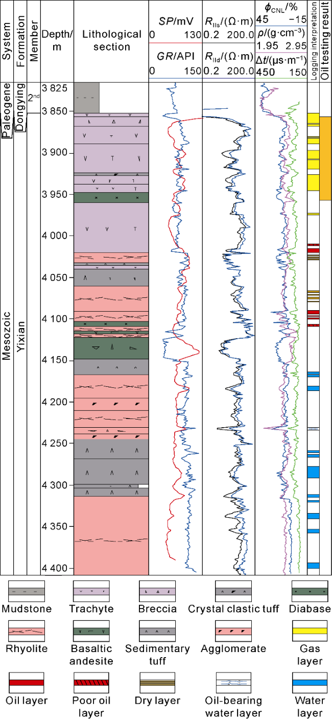
Fig. 2. Comprehensive column of volcanic rocks in Mesozoic Yixian Formation in Well LK7-A. SP - Spontaneous potential; GR - Gamma ray; Rlls - Shallow lateral resistivity; Rlld - Deep lateral resistivity; ϕCNL - Neutron porosity; ρ - Density; Δt - Interval transit time. |
2.2. Basic characteristics of oil and gas reservoirs
The reservoir lithologies in Well LK7-A are dominated by intermediate trachytic breccia, trachyte, and acidic rhyolite. Tuff and tuffaceous sandstones are underdeveloped. Reservoir spaces include porous and fractured-porous types, with log-derived porosity of 4.9%-18.5% and permeability of (0.01-2.70)×10-3 μm2. Laboratory measured porosity is 0.8%-29.7% and permeability is (0.000 1-1.970 0)×10-3 μm2. The fluid type in this well is gas-over- oil with gas at the top and oil at the bottom. The top gas layer was confirmed by testing and sampling at 3 930 m depth. The natural gas has a relative density of 0.663 4 g/cm3, with methane accounting for 87.31%, carbon dioxide accounting for 4.27%, nitrogen accounting for 0.33% and a dryness coefficient of 91.5%. The crude oil has a density of 0.805 2 g/cm3 (20 °C), a viscosity of 1.644 mPa·s (50 °C), a wax content of 13.20% and a solidification point of 19 °C, which is therefore classified as low-viscosity and low-wax light oil. The bottom oil layer was confirmed by sampling at 4 092.2 m, with 675 mL of oil sample obtained. The measured crude oil density is 0.851 3 g/cm3 (20 °C), the viscosity is 22.27 mPa·s (50 °C), the wax content is 23.00% and the solidification point is 36 °C, which is therefore classified as low-viscosity and low-wax medium oil.
3. Characteristics and genesis of Mesozoic volcanic rocks
3.1. Petrological features of volcanic rocks
Lavas, pyroclastic rocks and volcanic sedimentary rocks were drilled in LK7-A structure. The sequence is dominated by lavas, including trachyte, rhyolite and minor basaltic andesite (Fig. 3). The trachyte exhibits porphyritic texture with phenocrysts of plagioclase and alkali feldspar (15%-30%), displaying semi-aligned to aligned orientations. It exhibits pilotaxitic and trachytic textures (Fig. 3a, 3c, 3d). The matrix consists of K-feldspar, plagioclase microlites, magnetite, and glass, forming a massive structure with well-developed pores and microfractures (Fig. 3d). Rhyolite shows porphyritic texture with phenocrysts of quartz, feldspar and minor alkaline mafic minerals (aegirine-augite and arfvedsonite) (Fig. 3e). The matrix comprises felsic crystallites, cryptocrystalline material, and glass. Microfractures and dissolution pores are prevalent, often partially filled by calcite, quartz and clay minerals. The trachyte has undergone intense tectonic transformation, forming a large number of trachytic tectonic breccias (Fig. 3a-3c, 3f). Pyroclastic rocks include rhyolitic agglomerate, volcanic breccia and tuff with poorly developed pores and fractures.
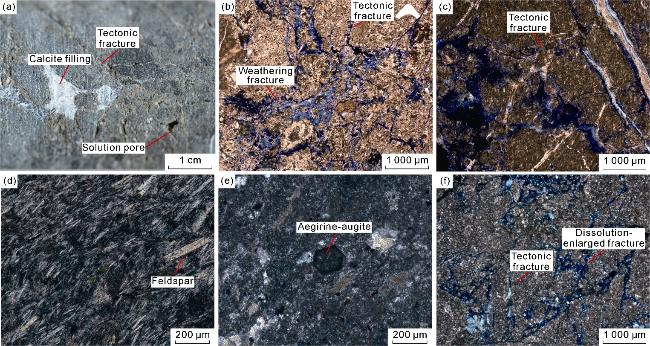
Fig. 3. Core samples and thin-section characteristics of Mesozoic volcanic rocks in LK7-A structure. (a) Well LK7-A, 3 904 m: Trachytic tectonic breccia derived from trachyte, with wall-rock core sampling; (b) Well LK7-A, 3 927 m: Tectonic breccia originating from welded tuff, plane-polarized light; (c) Well LK7-A, 3 995 m: Trachytic tectonic breccia with trachyte as protolith, plane-polarized light; (d) Well LK7-A, 4 011 m: Trachyte exhibiting semi-aligned to aligned feldspar phenocrysts, cross-polarized light; (e) Well LK7-A, 4 083 m: Rhyolite (pantellerite) containing aegirine-augite, cross-polarized light; (f) Well LK7-A, 4 337 m: Rhyolitic tectonic breccia derived from rhyolite, cross-polarized light. |
3.2. Geochemical characteristics of volcanic rocks
In the silicon-alkali classification diagram (TAS diagram), trachytes encountered in the two exploration wells LK7-A and PL7-A falling within the area of alkaline trachyte (quartz content (Qz) less than 20%), with SiO2 content ranging from 59.68% to 62.42% and total alkali (Na2O+K2O) contents from 9.39% to 10.35% (Fig. 4a). The K2O content is 3.42%-4.16%, all falling within the range of the shoshonite series on the SiO2-K2O diagram (Fig. 4b). The MgO content is 1.24%-1.40% and the TFe2O3 content is 5.26%-6.11%. The Al2O3 content is relatively high (17.06%-19.30%), and the CaO content is 1.30%-2.96%. The high ratio of K2O to Na2O contents (0.57-0.69) indicates its relative potassium enrichment.
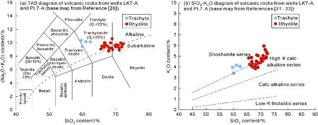
Fig. 4. Major element diagram of Mesozoic volcanic rocks from wells LK7-A and PL7-A (Ol—olivine). |
The rhyolite falls within the range of trachydacite (Qz> 20%)-rhyolite on the TAS diagram, with SiO2 content of 65.59%-72.39% and total alkali (Na2O+K2O) contents of 8.76%-10.60% (Fig. 4a). The K2O content is 3.84%-5.96%, and they fall within the range of high-K calc-alkaline-shoshonite series on the SiO2-K2O diagram, (Fig. 4b). The MgO content is 0.28%-2.19%, and the TFe2O3 content is 1.90%-4.30%. The Al2O3 content is relatively high (13.01%-16.51%), and the CaO content is 0.59%-3.68%. The ratio of K2O to Na2O contents (0.70-2.03) is high, which shows potassium-rich characteristics.
The rhyolites have similar trace element and rare earth element characteristics. Light rare earth elements (LREE) are relatively enriched, while heavy rare earth elements (HREE) are relatively depleted. Eu shows obvious negative anomalies. On the primitive mantle-normalized spider diagram, large ion lithophile elements (Ba and K) show strong positive anomalies, Sr shows no-positive anomalies, and high field strength elements (Nb, Ta, and Ti) show negative anomalies (Fig. 5a). The Sr content is higher compared to normal rhyolites ((253-662)×10-6), the Y content is low ((13.30-18.20)×10-6), and the Sr/Y ratios (15.49-39.17) are relatively high (Fig. 5b). On the Y-Sr/Y diagram, the samples mainly fall at the boundary between adakites and typical island-arc volcanic rocks. Combined with the trace element geochemical characteristics of enriching typical large ion lithophile elements and depleting high field strength elements, the rhyolites overall exhibit adakitic rock characteristics (Fig. 6).
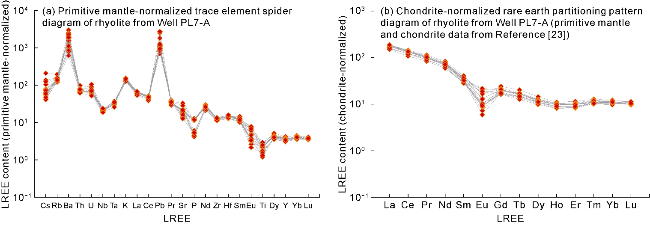
Fig. 5. Primitive mantle-normalized spider diagram and chondrite-normalized REE partitioning pattern diagram of volcanic rocks from Well PL7-A. |
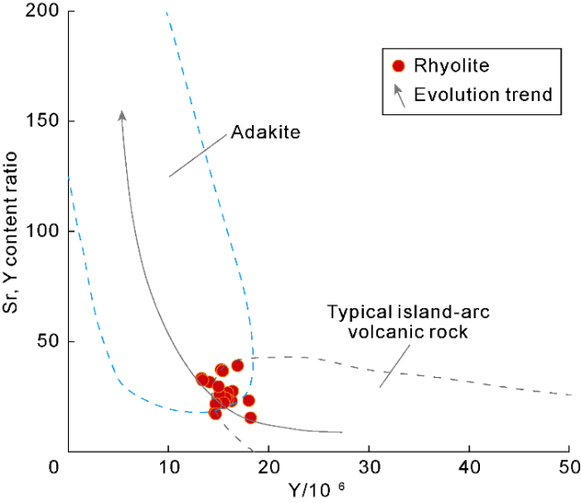
Fig. 6. Relational diagram of ratio of Sr to Y contents and Y of Mesozoic volcanic rocks from Well PL7-A (base map after Reference [24]). |
3.3. Volcanic rock genesis and emplacement mechanism
The rhyolites in the LK7-A structure exhibit relatively high Sr and low Y contents, strong positive anomalies in large ion lithophile elements (Ba and K), negative anomalies in high field strength elements (Nb, Ta, and Ti), which is consistent with the geochemical characteristics of adakites. Adakites were initially considered to be generated by partial melting of plates in subduction zones [22-23]. Due to the compositional similarity between magmas formed by partial melting of the mafic lower crust under eclogite-facies conditions and those formed by plate melting, some researchers have proposed that the lower crust serves as the source for certain adakitic rocks [24]. During the Late Mesozoic, widespread delamination of the lithosphere occurred in eastern China, where lithospheric mantle and part of the lower crust were subducted into the asthenospheric mantle, causing asthenospheric upwelling and underplating of the lower crust, thereby triggering large-scale magmatic activities [25]. Adakites in eastern China are generally C-type adakites closely related to lithospheric extension, with their source regions generating intermediate-acid magmas through partial melting under high-temperature and high-pressure conditions [26]. Meanwhile, the LK7-A structure is located in the Tan-Lu fault zone, where deep and large faults connect to deep magma chambers, allowing magma to upwell and form adakites dominated by trachyte and rhyolite.
On seismic profiles, volcanic rocks are distributed near the Tan-Lu strike-slip fault zone, vertically divided into two cycles: the early cycle and the late one. The early cycle consists of shield volcanoes with rock bodies occurring in bedded shapes, extensively lateral distribution, low aspect ratio, and internal parallel-subparallel reflections with weak amplitude and medium-high frequency. It is consistent with the characteristics of intermediate-basic effusive facies volcanic rocks. This set of volcanic rocks is widely distributed in the Bohai Sea, with zircon ages of 119-132 Ma [7]. Well PL7-A encountered this volcanic edifice at the bottom, revealing its lithology as basalt, which is intermediate-basic volcanic lava formed by asthenospheric upwelling from the mantle during delamination. A total of six volcanic edifices were interpreted in the late cycle (Fig. 7), partially overlapping from south to north, with a larger overall scale, presenting a low-hill shape and an overall aspect ratio smaller than that of lava domes. On the profile, multiple volcanic conduits with weak amplitude and chaotic reflection characteristics are observed, with the lower strata showing up-pull reflections and the interior showing a concave shape. The near to middle-source facies are distributed on both sides of the volcanic conduits, with seismic facies showing medium-strong amplitude, medium-low frequency and moderate continuous reflections. The far-source facies are distributed at the farthest end of the volcanic edifices, with seismic facies characterized by medium-weak amplitude, medium-high frequency and continuous reflections. This set of volcanic rocks is concentrated near the strike-slip fault zone, with regional zircon ages concentrated at 105-119 Ma [7]. Zircon U-Pb dating of Well PL7-A reveals that the rhyolite age is (115.7±1.9) Ma, which falling within the interval above. Well LK7-A encountered the near to middle-source facies of volcanic edifices No. 1 and No. 2, with drilling revealing them as volcanic rocks with interbedded intermediate-acid effusive and explosive facies, representing typical composite layer volcanoes [10]. Combined with the previous geochemical analysis, they are genetically adakites with a deep source region. The intermediate-acid magmas in the LK7-A structure provide a good foundation for the formation of large-scale reservoirs.
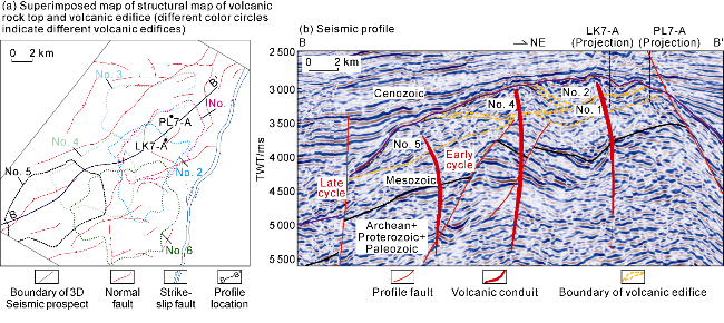
Fig. 7. Superimposed map of seismic facies characteristics and volcanic edifices of the LK7-A structure. |
4. Hydrocarbon accumulation conditions
4.1. Hydrocarbon source conditions
The Bodong Low Uplift is adjacent to the main hydrocarbon-generating subsags of the Bozhong Sag and Bodong Sag, possessing a favorable oil and gas supply background. According to laboratory data from surrounding drilled wells and well-seismic calibration, the Bodong Sag mainly develops three sets of source rocks, including the third member of the Shahejie Formation (Es3), the first and second members of the Shahejie Formation (Es1-Es2) and the third member of the Dongying Formation (Ed3) (Fig. 8a). The Es3 source rocks are sapropel-type dominated by Type II1 kerogen with partial Type I kerogen. The TOC values range from 0.20% to 3.44% and the hydrocarbon generation potential (S1+S2) ranges from 0.66 mg/g to 4.45 mg/g, indicating mainly medium-good source rocks. The Es1-Es2 source rocks are sapropel-mixed type dominated by Type I-II1 kerogen, with TOC values of 0.24%-5.93% and hydrocarbon generation potential (S1+S2) of 0.45-45.56 mg/g, indicating mainly medium-excellent source rocks. The Ed3 source rocks are consistent with the Es1-Es2 source rocks, showing sapropel-mixed type dominated by Type I-II1 kerogen, with TOC values of 0.63%-2.05% and hydrocarbon generation potential (S1+S2) of 1.76-10.84 mg/g, indicating mainly medium-good source rocks.
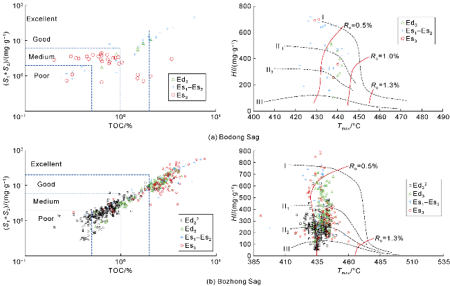
Fig. 8. Organic matter abundance and kerogen types of source rocks in the surrounding areas of the Bodong Low Uplift. |
The main subsag of the Bozhong Sag primarily develops four sets of source rocks: Es3, Es1-Es2, Ed3 and the lower submember of the second member of the Dongying Formation (Ed22) (Fig. 8b). All source rocks are dominated by exinite and sapropelinite with good organic matter types and higher hydrocarbon generation potential. The Es3, Es1-Es2 and Ed3 are mainly Type I-II2, while the Ed22 is dominated by Type II1-II2. The Es3 has TOC values of 0.66%-4.76% and hydrocarbon generation potential (S1+S2) of 1.62-19.72 mg/g, predominantly excellent source rocks; the Es1-Es2 has TOC values of 1.24%-5.56% and (S1+S2) of 4.33-16.72 mg/g, mainly good-excellent source rocks; the Ed3 has TOC values of 0.90%-4.34% and (S1+S2) of 2.34-22.16 mg/g, predominantly medium-excellent source rocks; the Ed22 has TOC values of 0.22%-3.56% and (S1+S2) of 0.28-16.25 mg/g, mainly poor-medium source rocks. As the drilled wells in both the Bozhong Sag and Bodong Sag are located in uplift areas and slopes, Ro values are concentrated at 0.55%-1.30% with a lack of samples with high thermal maturity. Basin modeling results show that the maximum Ro values at the base of the Cenozoic are 3.8% and 2.0%, respectively, in the Bozhong Sag and Bodong Sag.
4.2. Reservoir characteristics and genesis of high-quality reservoirs
4.2.1. Reservoir characteristics
Sidewall coring, cast thin sections and scanning electron microscopy (SEM) reveal significant differences in reservoir space types among different lithologies. The main reservoir spaces in tectonic breccia are secondary pores and fractures, including matrix dissolution pores, intergranular dissolution pores, weathering fractures, tectonic fractures and dissolution-enlarged fractures (Figs. 3a-3c and 9a-9e). Matrix dissolution pores and intergranular dissolution pores (Fig. 9a-9b) are relatively developed within the breccia clasts, mainly as sieve-like pores. Weathering fractures (Fig. 3b) are irregular fractures formed by weathering of volcanic rocks exposed at the surface, most developed near the weathering crust on the top of volcanic rocks, commonly presenting horsetail-like, en echelon-like, and leaf vein-like patterns. Weathering fractures intersect with tectonic fractures, dividing the rocks into blocks of varying sizes, which facilitates dissolution. Zeolites, argillaceous materials and carbonate minerals are commonly found to fill weathering fractures. Tectonic fractures (Figs. 3a-3c, 9g) are the main fracture type in the LK7-A structure, characterized by large scale, straight fracture surfaces and long extension distances, serving as important seepage channels in volcanic reservoirs. Multiple phases of tectonic fractures and their intersections can be observed in sidewall cores, mostly filled with siliceous or carbonate minerals. Dissolution-enlarged fractures (Fig. 9c) are formed by the secondary dissolution of feldspar, calcite, and ankerite filling in early tectonic fractures, resulting in widened fractures. The widths of the dissolution fractures vary, and they are most developed near the top weathering and dissolution zone. The main reservoir spaces in trachyte and rhyolite include primary pores, secondary pores and fractures, such as primary gas pores (Fig. 9d), intra-crystalline dissolution pores (Fig. 9e), condensed contraction fractures (Fig. 9f) and tectonic fractures. Due to the low volatile content in magma, primary pores account for a small proportion, mainly as elongated primary gas pores. Condensed contraction fractures are formed during the ascent of magma to the surface and effusion, when magma contacts with relatively low-temperature surrounding rocks, air, or water and cools rapidly. During solidification, the cooling magma undergoes quenching and rapid contraction, generating tensile stress that forms fractures. The condensed contraction fractures are abundant in lava with large extension scale but small aperture and they are formed early with high overall filling degree, commonly filled or semi-filled by chlorite, calcite, or quartz. Tuff generally has poorly developed reservoir spaces, dominated by secondary pores and fractures, such as intra-crystalline dissolution pores, devitrification pores (Fig. 9h) and microfractures. Devitrification pores are micro-pores formed by the transformation of volcanic glass from an amorphous to crystalline state, distributed in patches.
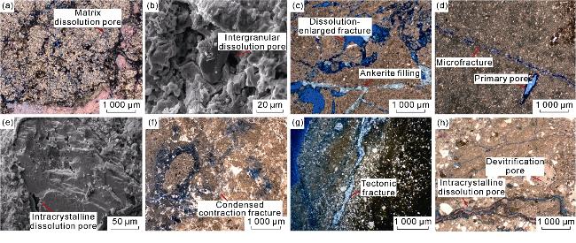
Fig. 9. Characteristics of reservoir spaces in Mesozoic volcanic rocks of the LK7-A structure. (a) Well LK7-A, Mesozoic, 3 885.0 m, tectonic breccia, matrix dissolution pores, plane-polarized light; (b) Well LK7-A, Mesozoic, scanning electron microscopy (SEM), trachytic tectonic breccia, intergranular dissolution pores, 3 904.0 m; (c) Well LK7-A, Mesozoic, 4 337.0 m, tectonic breccia, dissolution-enlarged fractures with ankerite-filled fractures, plane-polarized light; (d) Well LK7-A, Mesozoic, 3 995.0 m, trachyte, primary pores and micro-fractures with partial filling, plane-polarized light; (e) Well LK7-A, Mesozoic, 4 383.5 m, rhyolite, intracrystalline dissolution pores, SEM; (f) Well LK7-A, Mesozoic, 4 184.0 m, rhyolite, condensed contraction fractures, plane-polarized light; (g) Well LK7-A, Mesozoic, 4 312.0 m, tuff, tectonic fractures with ankerite semi-filled fractures, plane-polarized light; (h) Well LK7-A, Mesozoic, 4 033.0 m, tuff, devitrification pores and intracrystalline dissolution pores, plane-polarized light. |
The porosity of Mesozoic volcanic rocks in Well LK7-A ranges from 4.9% to 18.5%, and the permeability is (0.01-2.70)×10-3 μm2. Therefore, it is classified as reservoirs with medium porosity and low permeability and reservoirs with high porosity and low permeability, with a small number of reservoirs with medium porosity and medium permeability, and medium porosity and ultra-low permeability. Among them, tectonic breccia reservoirs have the best physical properties, trachyte and rhyolite reservoirs have moderate properties and tuff reservoirs have poor properties.
Mercury intrusion porosimetry (MIP) and micro-CT scanning reveal significant differences in pore-throat structures and connectivity among different lithologies. Tectonic breccia exhibits wide capillary pressure curve platforms, with average pore-throat radii of 0.053-0.116 μm, indicating the predominance of micro-pores. It shows high maximum mercury saturation (78.13%- 82.81%, average 80.91%) (Table 1 and Fig. 10). CT scanning shows an effective porosity of 6.62%, average pore radius of 18.16 μm and average throat radius of 17.07 μm, indicating good reservoir physical properties. Trachyte has almost no capillary pressure curve platform with an average pore-throat radius of 0.021 μm, indicating the predominance of micro-pores. The maximum mercury saturation is moderate (43.51%-84.14%, average 64.9%) with an effective porosity of only 3.06% from CT scanning, average pore radius of 13.57 μm and average throat radius of 8.10 μm, showing moderate reservoir properties. Rhyolite has wide capillary pressure curve platforms, an average pore-throat radius of 0.019 μm (predominantly nanoscale pores), moderate maximum mercury saturation (67.77%-92.54%, average 78.54%), effective porosity of 1.92%-5.82% from CT scanning, average pore radius of 13.73-14.66 μm, and average throat radius of 8.01-9.27 μm, indicating an overall poor pore connectivity. Tuff shows large variations in capillary pressure curves, showing average pore-throat radius of 0.007-0.024 μm (predominantly ultra-micro pores) and low-moderate maximum mercury saturation (35.22%-83.35%), which is characterized by low porosity and low permeability. Therefore, tectonic breccia has a high proportion of large-pore spaces with good connectivity; trachyte and rhyolite have relatively uniform pore distributions with smaller apertures and moderate connectivity; tuff is dominated by small pores with the poorest connectivity.
Table 1. High-pressure mercury injection porosity structure parameters of representative Mesozoic volcanic rock samples from Well LK7-A |
| Lithology | Depth/ m | Porosity/ % | Pore volume/ (cm3·g-1) | Maximum pore-throat radius/μm | Average pore-throat radius/μm | Relative sorting coefficient | Maximum mercury intrusion saturation/% | Mercury withdrawal efficiency/% | Expulsion pressure/ MPa |
|---|---|---|---|---|---|---|---|---|---|
| Trachyte | 3 898.5 | 6.51 | 0.026 3 | 0.111 | 0.023 | 0.979 | 67.29 | 0.01 | 6.64 |
| 3 973.0 | 15.95 | 0.061 9 | 0.111 | 0.033 | 0.633 | 84.14 | 45.46 | 6.60 | |
| 4 011.0 | 3.68 | 0.014 6 | 0.028 | 0.008 | 0.624 | 43.51 | 15.56 | 25.98 | |
| Rhyolite | 4 071.0 | 9.50 | 0.039 4 | 0.086 | 0.026 | 0.578 | 75.31 | 26.21 | 8.60 |
| 4 232.0 | 29.71 | 0.161 2 | 0.047 | 0.018 | 0.555 | 92.54 | 59.53 | 15.78 | |
| 4 354.0 | 3.56 | 0.014 1 | 0.047 | 0.014 | 0.599 | 67.77 | 14.06 | 15.70 | |
| Tuff | 4 277.0 | 11.37 | 0.046 6 | 0.016 | 0.007 | 0.428 | 35.22 | 9.65 | 46.95 |
| 4 285.0 | 14.40 | 0.062 2 | 0.084 | 0.024 | 0.668 | 83.35 | 29.46 | 8.75 | |
| 4 312.0 | 14.59 | 0.062 5 | 0.037 | 0.015 | 0.535 | 70.42 | 30.72 | 19.99 | |
| Tectonic Breccia | 3 858.5 | 12.94 | 0.055 6 | 0.366 | 0.116 | 0.682 | 81.80 | 43.08 | 2.01 |
| 3 904.0 | 12.91 | 0.052 9 | 0.881 | 0.089 | 1.932 | 78.13 | 35.05 | 0.84 | |
| 3 941.0 | 10.12 | 0.042 0 | 0.259 | 0.053 | 0.732 | 82.81 | 6.55 | 2.83 |
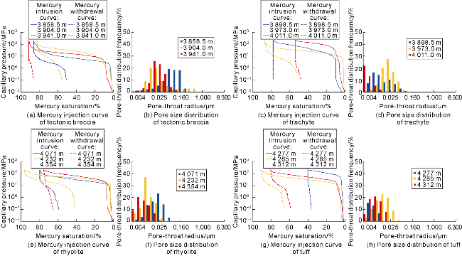
Fig. 10. High-pressure mercury intrusion curves (a, c, e, g) and pore size distribution characteristics (b, d, f, h) of Mesozoic volcanic reservoir in Well LK7-A. |
Overall, tectonic breccia has a large proportion of large-aperture pores and high content of soluble components, which easily form slightly large dissolution pores and are conducive to the formation of high-quality reservoirs. Trachyte and rhyolite have a large proportion of small-aperture pores, with intercrystalline pores and devitrification pores as the main types of reservoir spaces, and relatively less developed dissolution pores, making it difficult to form high-quality reservoirs. Tuff has almost no large pores and poor pore-throat connectivity, making it difficult to form high-quality reservoirs.
4.2.2. Main factors controlling high-quality reservoirs
Sidewall cores and cast thin sections from Well LK7-A show diverse reservoir space types in volcanic reservoirs, including primary pores formed by volatile exsolution, dissolution pores and weathering fractures formed by weathering, tectonic fractures and associated dissolution pores formed by tectonism, condensed contraction fractures formed by volcanic rock condensation and contraction, and devitrification micropores formed by post-eruption devitrification. Lithology, lithofacies and volcanic edifices serve as the foundation for the formation of large-scale volcanic reservoirs, while tectonic fracturing and late-stage intense weathering are key to their development.
4.2.2.1. Intermediate-acid effusive facies providing a foundation for high-quality reservoirs
Volcanic rocks of different lithologies and lithofacies vary in the difficulty of forming reservoirs. The LK7-A structure develops volcanic rocks of different lithologies and lithofacies, whose distribution rules directly affect the distribution range of high-quality reservoirs (Fig. 11). The upper interval of Well LK7-A is dominated by trachyte of the lower subfacies of effusive facies and trachytic tectonic breccia, interbedded with thin layers of volcanic conduit facies, explosive facies, and volcanic sedimentary facies. The middle interval mainly develops volcanic sedimentary facies, rhyolite of the lower subfacies of effusive facies, and rhyolitic agglomerate of the air-fall subfacies of explosive facies, with basaltic volcanic rocks of effusive facies, volcanic conduit facies, and explosive facies additionally developed. The top of the lower interval is interbedded tuff of explosive facies and volcanic sedimentary facies, with large sets of rhyolite of the lower subfacies of effusive facies developed in the lower part. The reservoirs in Well LK7-A are concentrated within the top 100 m of intermediate effusive facies lava. The upper interval of Well PL7-A mainly develops trachyte and rhyolite of the lower subfacies of effusive facies, interbedded with volcanic sedimentary facies. The lower interval is dominated by large sets of rhyolite of the lower subfacies of effusive facies, interbedded with thin explosive facies. The reservoirs in Well PL7-A are concentrated in the acidic effusive facies lava within the top 250 m. The entire interval of Well LK2-A is dominated by basic and intermediate tuff, with poorly developed reservoirs, except for 6 m of good reservoirs developed at the top. Therefore, intermediate-acid effusive facies are the relatively favorable lithologies and lithofacies in the study area. Triaxial stress simulation experiments show that when the axial extension rate is constant, the deviatoric stress value of lava is lower than that of pyroclastic rocks and sedimentary pyroclastic rocks. Lava-type volcanic rocks are more prone to fracturing, making them the most favorable lithology for forming high-quality reservoirs.
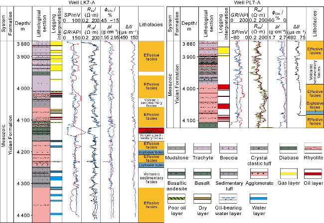
Fig. 11. Lithology-lithofacies and reservoir correlation in the LK7-A volcanic structure. |
4.2.2.2. Tectonic fractures and late intense weathering controlling the formation of top high-quality reservoirs
After the early Cretaceous volcanic rocks of the LK7-A structure were in place, they were influenced by the subduction of the Late Yanshanian Paleo-Pacific Plate, leading to strong NWW-trending compression in the region and NE-trending strike-slip faults, which together with the eastern branch of the Tan-Lu strike-slip fault controlled the evolution of the buried-hill in the Bodong Low Uplift. Near the strike-slip faults and their associated fractures, a large number of tectonic fracture zones and cracks were developed in the volcanic rocks. The southern segment of the Bodong Low Uplift was affected by the Late Yanshanian and Himalayan tectonic movements, resulting in folding deformation of the Mesozoic strata. The western side of the uplift suffered the most severe deformation, with more fragmented structures and extremely developed fractures. Tectonic fracturing created favorable conditions for subsequent weathering and the formation of large-scale reservoirs.
The Mesozoic volcanic rocks in the LK7-A structure were formed in the Early Cretaceous, with a zircon age of approximately 115 Ma. They are overlain by the Cenozoic Dongying Formation (Ed), lacking the Upper Cretaceous and the Paleogene Kongdian Formation (Ek) and Shahejie Formation (Es) in the Paleocene-Eocene. The volcanic rocks have undergone approximately 70-80 million years of weathering and erosion, and the volcanic reservoir has been significantly modified by weathering. Major element analysis shows that the top of the volcanic rocks in the LK7-A structure is enriched in non-leachable elements such as Fe and Al, while leachable elements like Ca, Mg, and Na are depleted (Fig. 12), indicating that the top of the volcanic rocks has been affected by weathering, with leachable elements migrating. The chemical weathering index gradually decreases from the top downward, forming a turning point at 300 m, suggesting that the thickness of weathered volcanic rocks reaches 300 m. The Well LK7-A encountered diabase in the 4 100-4 120 m interval, which is a late intrusive rock that affected the depth of weathering, leading to local anomalies in the weathering index. Affected by weathering, the reservoir physical properties of the weathering crust at the top of the volcanic rocks are generally better, with well-developed secondary dissolution pores and fractures. The reservoir effectiveness of the lower parent rock zone decreases, with reservoir spaces dominated by tectonic fractures and primary gas pores.
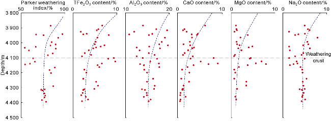
Fig. 12. Variation trends of major elements and weathering indices in Mesozoic volcanic rocks of Well LK7-A. |
4.3. Hydrocarbon migration and accumulation conditions
The Bodong Low Uplift is sandwiched between two long-term active boundary faults, in extensive and long-distance contact with source rocks in the Bodong Sag and Bozhong Sag, making it a dominant target area for oil and gas migration toward the uplift. According to oil and gas migration and accumulation simulations and resource allocation, the LK7-A structure receives approximately 8.61×10⁸ t of oil and gas resources from the two adjacent sags, including 6.75×10⁸ t from the Bozhong Sag and 1.86×10⁸ t from the Bodong Sag, providing a material basis for high-abundance hydrocarbon accumulation (Fig. 13).
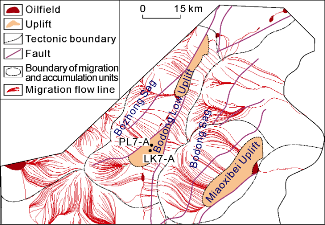
Fig. 13. Hydrocarbon migration units in the Bodong Low Uplift. |
Affected by intense tectonic activity and long-term weathering and leaching, the intermediate-acid volcanic semi-weathered rocks on the top surface of the buried-hills in the Bodong Low Uplift have well-developed pores and fractures, which are interconnected to form efficient transport layers, providing good channels for oil and gas migration and accumulation. The source rocks are generally overpressured, with currently measured excess pressures in drilled wells ranging from 10 MPa to 35 MPa and pressure coefficients of 1.2 to 1.8. Using pre-stack seismic inversion volumes and internal seismic attributes, formation pressures are predicted based on multi-attribute regression, with deep formation pressures in the sags reaching approximately 150 MPa, residual pressures of approximately 75 MPa, and maximum pressure coefficient of up to 1.9, providing sufficient driving force for efficient oil and gas migration to the buried-hills.
During the sedimentary period of the Dongying Formation, the uplift and its surrounding areas were dominated by lacustrine sediments, with local delta front deposits. The lithological assemblage consists of thick mudstone interbedded with thin sandstone. Drilled wells reveal stable formation thicknesses in the Dongying Formation, approximately 441-541 m, with low sand content (14.4%-18.4%), showing low-frequency continuous weak reflection characteristics on seismic profiles, with predicted thicknesses exceeding 450 m (Fig. 14). This forms a good combination with the Mesozoic volcanic buried-hills. Overpressured caprocks have stronger sealing capabilities than normal-pressure caprocks [27]. The measured pressure coefficient in Paleogene sandstones of Well PL7-A is 1.48, and the formation pressure coefficient predicted by mud logging data in Well LK7-A is 1.64. The Eaton method [28] predicted pressure coefficients exceeding 1.45 in the study area and surrounding areas. According to the matching relationship between pressure coefficients and hydrocarbon column heights in the Bohai Sea, the LK7-A structure is predicted to have sealing conditions for forming high hydrocarbon columns, with hydrocarbon column height in oil and gas reservoirs potentially reaching 800 m.
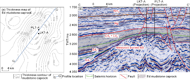
Fig. 14. Thickness map of Dongying Formation mudstone caprock (a) and seismic profile (b) across the Bodong Low Uplift. |
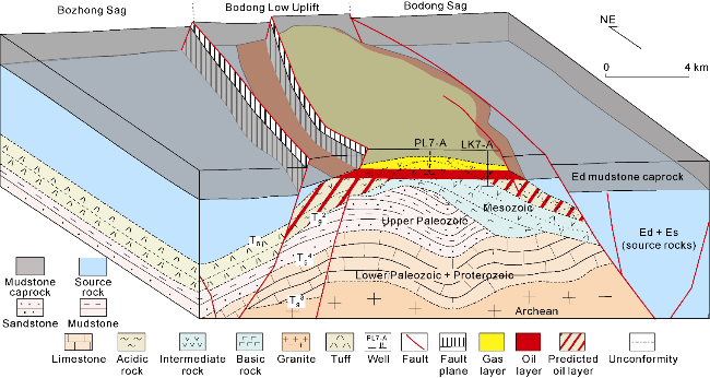
4.4. Hydrocarbon accumulation model
Based on the above analyses, a hydrocarbon accumulation model of ‘hydrocarbon supply from double sags and overpressure sealing’ for Mesozoic volcanic buried-hills in the Bodong Low Uplift was established in this paper (Fig. 15). The oil and gas in the Bodong Low Uplift are mainly derived from the source rocks of the Shahejie Formation and Dongying Formation in the Bozhong Sag and Bodong Sag. These source rocks feature high maturity and strong hydrocarbon generation capacity. The main subsag of the Bozhong Sag is in the over-mature stage, enabling large-scale gas generation. Moreover, the source rocks have high pressure coefficients and large residual pressures, where the overpressured source rocks provide sufficient driving force for oil and gas migration. The top surface of the Mesozoic volcanic rocks has undergone intense weathering and leaching modification, exhibiting favorable porosity and permeability conditions. It is continuously and stably distributed near the unconformity surface, serving as an excellent oil and gas reservoir and an efficient migration pathway. The Mesozoic is overlain by a thick overpressured mudstone caprock exceeding 450 m in thickness, which is stably developed in the Dongying Formation and has a pressure coefficient of 1.4-1.6. This thick overpressured mudstone provides good top-sealing conditions for lateral oil and gas migration. Reservoirs around the Bozhong Sag have generally experienced two phases of hydrocarbon charging [29]. These mainly include a large-scale crude oil charging event occurring at 12 Ma, which formed paleo-reservoirs, and a large-scale natural gas charging event since 5.1 Ma, which mixed with the early-formed crude oil [30-31] to form gas-over-oil reservoirs. Controlled by complete faulted anticline traps and continuously distributed weathering crusts at the top, oil and gas are distributed in a layered manner along the top surface of the buried-hills.
Fig. 15. Hydrocarbon accumulation model of buried-hill in the Bodong Low Uplift. |
5. Exploration implications and favorable exploration targets
The offshore part of the Bohai Bay Basin is situated in the context of strong transformation by the Tan-Lu fault zone, with intense tectonic activity. Intermediate-acid volcanic lavas, which are easily transformed, are more conducive to the formation of high-quality reservoirs. Therefore, it is necessary to clarify the favorable zones for volcanic rock exploration based on understanding the origin of regional volcanic rocks, and determine the most favorable development areas of volcanic lavas through the identification and characterization of fine volcanic edifices in target areas. Meanwhile, the drilling of Well LK7-A has confirmed that volcanic reservoirs are mainly fractured-porous type, significantly influenced by tectonic and weathering transformations. Areas close to fault zones and paleogeomorphic highs are more conducive to the development of local high-quality reservoirs. In addition, the physical properties of volcanic reservoirs mainly have medium-porosity low-permeability and high-porosity low-permeability, with poor pore connectivity. Stronger charging conditions can significantly reduce the physical property threshold, providing conditions for large-scale migration of oil and gas. Volcanic rocks in hydrocarbon-rich sag with overpressure background are more prone to large-scale hydrocarbon accumulation. Therefore, intermediate-acid volcanic bodies within hydrocarbon-rich sags, strongly transformed by tectonic activity and weathering, are ideal sites for large-scale oil and gas discoveries in Mesozoic volcanic rocks.
Different from the strike-slip extension dominated tectonic background in the Shijiutuo Uplift and its surrounding areas in western Bohai, the LK7-A structure is sandwiched by the strong strike-slip Tan-Lu Fault. Deep and large faults, as important channels connecting magma chambers, have led to the widespread development of adakites with large source depths in this area, which are prone to forming large-scale intermediate-acid volcanic rocks and are also favorable development areas for near-medium source dominant lithofacies. At the same time, tectonic fractures formed by the late activation of early-developed faults provide good conditions for subsequent weathering and leaching. Therefore, volcanic edifices near faults may have more favorable conditions for the development of high-quality reservoirs. The volcanic edifice of the LK7-A structure is generally sandwiched between two boundary strike-slip faults, with an undrilled igneous rock body area exceeding 200 km2. With intense tectonic and weathering effects, it is predicted that its weathering crust is better developed, having the exploration potential to form large oil and gas fields. In the northern segment of the Bodong Low Uplift, both the LK2-A structure (Fig. 1) and the Mesozoic of the southern segment LK7-B structure widely develop large-scale volcanic strata synchronous with the volcanic rocks encountered in Well LK7-A. The lithology is predicted to be intermediate-acid trachyte and acidic rhyolite. Both structures are sandwiched between the long-term continuously active Tan-Lu strike-slip faults. Among them, the volcanic body area of the LK2-A structure is approximately 85 km2, and the Mesozoic buried-hill trap area of the LK7-B structure is approximately 30 km2. Both are adjacent to the main subsags of the Bozhong Sag and Bodong Sag, overlain by thick overpressured mudstone of the Paleogene Dongying Formation, with better caprock conditions, having the exploration prospect of forming medium to large oil and gas fields. In addition, adakitic volcanic rocks with large source depths are widely developed in the strong strike-slip area around the Bozhong Sag, with the development of intermediate-acid volcanic rocks. Tectonic areas with similar tectonic backgrounds, such as BZ22-A and BZ16-A are favorable zones for future exploration.
6. Conclusions
The Mesozoic volcanic rocks in the LK7-A structure of the Bodong Low Uplift are mainly composed of intermediate trachyte, trachytic tectonic breccia, and acidic rhyolite. Geochemical characteristics show adakitic rock features. Combining the drilled data of the Bozhong Sag area, regional tectonic background, and major/trace element characteristics, the volcanic rocks in the target area are adakites with deep source regions, dominated by intermediate-acid volcanic rocks.
Tectonic breccia and intermediate-acid lava are the main lithologic types for developing high-quality reservoirs, with fractures and pores as the main reservoir space types. These reservoirs are predominantly high-porosity low-permeability and medium-porosity low-permeability, consisting mainly of micro-medium pores, with medium pores accounting for a larger proportion. Lithology-lithofacies and volcanic edifices serve as the fundamental conditions for forming large-scale volcanic reservoirs. The intermediate-acid effusive facies are favorable lithology and lithofacies in the study area. Tectonic fracturing and late strong weathering are key factors in the formation of large-scale volcanic reservoirs. The weathering crust within 300 m of the volcanic rock top generally has better physical properties and is a key exploration interval.
The LK7-A structure receives hydrocarbon supply from the main subsags of the Bozhong Sag and Bodong Sag. Overpressured source rocks provide sufficient driving force for hydrocarbon migration. The buried-hill is covered by overpressured mudstone caprock with a thickness exceeding 450 m and a pressure coefficient exceeding 1.45. Calculations show the oil and gas resources are approximately 861.108 million tons, predicting that the LK7-A structure has conditions for high-abundance hydrocarbon accumulation. Meanwhile, the surrounding LK7-B and LK2-A structures also have superior trap backgrounds, with well-developed favorable lithologies and reservoirs. The widely exposed acidic volcanic edifices still hold significant oil and gas exploration prospects.