

Introduction
With the continuous deepening of unconventional oil and gas exploration and development, coalbed methane has become a prominent field for large-scale increase in reserves and production of unconventional oil and gas in China in the future [1-2]. Traditional coalbed methane exploration in China mainly focuses on the middle and shallow layers where coal seams are shallower than 2 000 m [3]. However, coal-rock gas with a burial depth of more than 1 500 m has unique geological characteristics com-pared with traditional coalbed methane and is a new type of unconventional natural gas between conventional gas and traditional coalbed methane [4]. The successful trial production of Well Jishen 6-7 P01 in Daning-Jixian of eastern margin of Ordos Basin, NW China, in 2021 marked a breakthrough in the exploration and development of coal-rock gas in China [5]. According to the new round of evaluation on coal-rock gas resources by the Ministry of Natural Resources, the resource volume of coal-rock gas at 1 500-3 000 m is approximately 30.37× 10¹² m3. It is twice the amount of coalbed methane (CBM) resources shallower than 1 500 m [6]. The potential of deep coal-rock gas resources is huge, and they are alternative resources in unconventional natural gas exploration in China in the future [7-11].
The exploration has demonstrated that coal-rock gas resources in China are mainly distributed in coal-bearing basins of different geological periods, including the Late Carboniferous-Permian, Early-Middle Jurassic and Late Jurassic-Early Cretaceous [12-13]. The Late Carboniferous-Permian and the Early-Middle Jurassic coal-bearing basins are large and extra-large marine-continental transitional and inland depression basins with stable structures. The sedimentary thickness of the coal-bearing strata is relatively stable and continuous, and the gas generation capacity of the coal seams is strong. Breakthroughs to coalbed methane exploration and development have been made in the Ordos Basin, Junggar Basin and Turpan-Hami-Santanghu Basin [14-16]. The Late Jurassic-Early Cretaceous coal-bearing basins are almost small rifted ones where the number of coal seams varies greatly, and the lateral change of the single-layer thickness is large due to frequent tectonic activities, making it difficult to accurately describe the distribution law of the main coal seams [17-19]. Achievements and progress have been made in the exploration and development of coal-rock gas in rift basins such as Songliao Basin, Bohai Bay Basin, Hailar Basin and Erlian Basin [20-24]. However, the relationship between coal-rock gas and fault system has been unclear, especially in the basin with significantly developed faults. How the fault systems control the spatial distribution of coal seams and affect the preservation law of coal-rock gas should be further investigated to make breakthrough to the exploration and development of coal-rock gas in those rift basins. Taking the southern Songliao Basin of China where coal seams are widely developed in the deep formations, coal-rock gas is as a case for risk exploration [17], this paper investigates the fault development in the Wangfu fault depression under the guidance of structural analysis theory, clarifies the fault deformation mechanism of the coal-bearing fault depression, estimates the fault activity period of the coal-bearing strata and divides the fault system. Moreover, the controls of fault system on the spatial distribution of coal seams and the preservation conditions of coal-rock gas are revealed, and a fault-controlled coal-rock gas enrichment model for rift basins is constructed. The research findings provide a theoretical basis and a practical guidance for the exploration and development of coal-rock gas in rift basins.
1. Regional geology
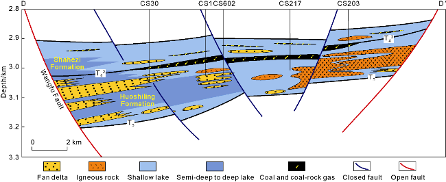
The Songliao Basin is a Meso-Cenozoic continental rift- depression basin [25]. The Wangfu fault depression located in the southern part of the Songliao Basin is surrounded by Yingshan, Yushu and Dehui fault depressions (Fig. 1a). Songliao Basin is a superimposed basin with a dual-layer structure composed of "bottom fault and top depression" vertically [26-27]. After experiencing three stages, namely rifting, sagging and structural inversion [28-29], it developed three major structural layers: a fault depression layer composed of the Lower Cretaceous Huoshiling Formation (K1h), Shahezi Formation (K1sh) and Yingcheng Formation (K1y), a depression layer composed of the Lower Cretaceous Denglouku Formation (K1d) and Quantou Formation (K1q) and the Upper Cretaceous Qingshankou Formation (K2qn), Yaojia Formation (K2y) and Nenjiang Formation (K2n), and an inversion layer composed of the Upper Cretaceous Sifangtai Formation (K2s) and Mingshui Formation (K2m) and the Cenozoic [30-31] in ascending order (Fig. 1b). The fault depression layer is mainly composed of fan delta facies and lacustrine facies, and includes main coal seams. Until 2024, 135 exploration wells have been drilled into the deep formations in the southern Songliao Basin, and coal seams have been encountered in several fault depressions such as Dehui, Wangfu, Fulongquan and Gudian. The coal seams are typical coal-rock gas layers generally deeper than 2 000 m [20]. The main coal seams in the Wangfu fault depression are found at the top of the Huoshiling Formation (T42), and the single-layer thickness is 1.7-11.2 m and 3.3 m on average. The thick coal seams are effective coal-rock gas layers. In contrast, the coal seams in the Shahezi Formation and the Yingcheng Formation are interbedded coal or coal bands, which are relatively thin and have less coal-rock gas resources. In terms of coal rank, the coal seams in the Wangfu fault depression are mostly high gas coal and gas coal as bituminous coals, with high coal ranks and strong methane generation capacities. In conclusion, the content of coal-rock gas in main coal seams such as the Lower Cretaceous Huoshiling Formation in the study area is relatively high [20], with both good preservation conditions and generation capacity, providing a good development prospect and potential.
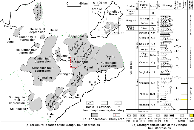
Fig. 1. Location and stratigraphic column of the Wangfu fault depression in the Songliao Basin [32]. |
2. Characteristics and deformation mechanisms of basement faults
The basement fault system within the Wangfu fault depression represents a significant controlling effect on the structural deformation of coal-bearing fault depression and the sedimentary-filling process of coal seams. Considering with regional tectonic setting, this paper systematically describes and analyzes the basement faults, and then discusses the coal seam development environment and the fault-controlled mechanism of coal seam.
2.1. Distribution of basement faults
The boundary faults of the Wangfu fault depression are NE- and SN-striking faults. The basement fault deformation mechanism in Songliao Basin has long been a hot topic for tectonic research. Generally, there are four groups of faults in NE-NNE, NW-NNW, nearly SN and nearly EW directions in the basement of the Songliao Basin (Fig. 2a), which are highly active and control the development of the rift basin in multiple directions [32]. The NE-NNE-striking faults are widely distributed throughout the basin, and they are stable laterally and consistent with the axial direction of the basin. Especially in the southern region, they are numerous and the largest in scale, and obviously control the fault depressions such as Dehui, Yingshan and Qianbei (Fig. 2b). The NW-NNW-striking faults and the NE-NNE-striking faults interact with each other, forming a reticular structure. They are less in the southern region, but still control the fault depression deposits distributed in the NNW-striking direction. More nearly SN-striking faults are found in the fault depression layer in the southern region. Most of them connect with the NE-NNE-striking faults laterally, and they jointly control the formation of fault depressions, such as Wangfu, Lishu and Fulongquan (Fig. 2b-2d).

2.2. Deformation mechanisms of basement faults
The abovementioned first three groups of faults were all associated with intense stretching activities during the rifting stage of the Songliao Basin (Fig. 2c and 2d). The Early Cretaceous NW-SE-striking extension may explain the NE-striking fault activities, but cannot explain the phenomenon that the three groups of faults with different orientations all strongly extended in the same stage on the uniform basement. It has been found that Northeast China and even Northeast Asia were under a complex dynamic background during the Late Mesozoic[32-34]. First, during the Late Jurassic and Early Cretaceous, the Mongolia-Okhozsk Ocean closed from west to east, forming a compressive orogenic environment [35-36], which led to the southward movement of the Siberian Plate. Second, the paleo-Pacific Plate subducted toward NNW-NW beneath the Eurasian Plate during the Early Cretaceous [37-38]. The combination of the two formed a powerful sinistral transpressional coupling effect. Under this effect, the Yilan-Yitong Fault Zone in the northern section of the Tancheng-Lujiang Fault Belt underwent large-scale sinistral strike-slip activities and induced intense transpressional strike-slip deformation in the Songnen Block, resulting in a series of sinistral strike-slip derivative structures, namely the NE-NNE-striking R-shear rupture, the NW-striking R' shear rupture and the nearly NS-striking T-rupture (Fig. 2a).
The pre-existing structure played an important controlling role in the formation and evolution of the fault system within the Songliao Basin. Located within the transpressional strike-slip deformation zone, and the deformation of the basement faults took place in the same period as plate interaction [32], it’ s inferred that the multi-directional basement faults might develop on the sinistral strike-slip derived faults. The NNE section was assigned to the pre-existing R-shear rupture, the nearly SN-striking section to the T-rupture, and the NW-striking section to the R°-shear fault. Later, after extension or oblique extension under the influence of NW-SE-striking and SN-striking stress fields in Early Cretaceous, they evolved into boundary faults that controlled the formation of fault depression (Fig. 2b). For example, the Wangfu fault depression was formed under the joint control of the R-shear rupture and the T-rupture.
3. Characteristics and phase/type division of faults in coal-bearing strata
Influenced by geological processes such as rifting tension and igneous rock intrusion, stably distributed major coal seams were formed in the Wangfu fault depression at the end of the sedimentation of the Huoshiling Formation. This paper mainly analyzes the distribution and activities of faults at the top of the Huoshiling Formation (T42), and divides the fault system.
3.1. Fault distribution
On plane, the top of the Huoshiling Formation (T42) in the Wangfu fault depression has large-scale normal faults with dominant SN and NE strikes (Fig. 3a). The SN-striking faults are most widely distributed in the middle and east of the fault depression. The middle faults are relatively small and dense, while the eastern are large, scattered and linearly arranged in vertical direction. The NE-striking faults are mainly distributed in the marginal areas such as the northwestern and southern parts of the fault depression. Some occur in the middle and connect with the SN-striking faults to form composite striking faults. This is closely related to the fact that the direction of the Wangfu Fault is mainly SN-striking and the regional extension stress field is NW-SE-striking. In addition, the NW- and NWW-striking faults sporadically distributed played a role in transformation and regulation.
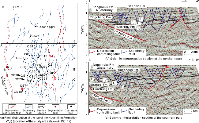
Fig. 3. Plane distribution and seismic interpretation section of secondary faults for major coal seams in the Wangfu fault depression. |
On section, detailed seismic interpretation found that the Wangfu fault depression is a dual-fault asymmetric graben controlled by the nearly SN-striking Wangfu Fault and SN-NE-striking composite faults (Fig. 3b and 3c), which is different from a dustpan-like semi-graben composed of a single type of faults previously understood. Specifically, the southern boundary faults have large throws, significant difference in thickness on both sides, and a distinct graben morphology. The northern boundary faults have small throws, and only control the Huoshiling Formation. The Shahezi Formation and the Yingcheng Formation are thin and pinched out eastward to the T42 reflector. In the vertical direction, the boundary faults extend in a large range. Most of them keep active at medium to high dip angles a long time, and only the Wangfu Fault is active at a low dip angle gently. It is locally steep at the top and gentle at the bottom, presenting a shovel shape (Fig. 3c). The secondary faults are distinctly layered, which are mainly plate-like. Most of them only disrupt the T5 reflector, and some through the T42 reflector, presentiong a "domino" or "horst-graben" com-binations. The faults within the depression layer are concentrated on the hanging walls of large faults, forming a series of simple “y”-shaped or inverse “y”-shaped structural patterns, with a significantly increasing density. Some are only above the T4 reflector, and others break downward through T4, T41, and even T42, resulting in multiple active faults on T42.
3.2. Fault activities
For the multi-stage active faults, three typical faults f1-f3 were selected to plot the throw-burial depth curve and growth index (Fig. 4). It is found that the maximum throw of fault f1 occurs at the T42 reflector (Fig. 4b), and then gradually decreases towards deep and shallow layers, indicating that the fault nucleated during the rifting period. The faults extend to shallow layers vertically and the growth index is greater than 1 within the Shahezi Formation-Yingcheng Formation, indicating they were active for a long time after formation. The faults partially confined within T4 and T42 were formed at the same time as fault f1, but only active during the rifting period (Fig. 4a). The vertical extension of fault f2 is limited, with the maximum throw occurring above T4 and gradually decreasing towards deeper layers. The growth index is less than 1 within the fault depression layer, indicating that f2 is the product of the sagging stage (Fig. 4b). Fault f3 runs vertically through all layers, with growth index always higher than 1 during the entire rifting period. The cumulative throw gradually increases downward, and the maximum occurs at the T5 reflector (Fig. 4b), indicating that the fault may be formed during the early rifting stage or originated from a pre-existing fault. Due to the great similarity in direction and occurrence, and considering the regional stress, f3 may be consistent with the Wangfu Fault, namely both are reactivated basement faults. Other faults formed simultaneously with f3 only penetrated the T5 reflector and were only active within the Huoshiling Formation (Fig. 4a).
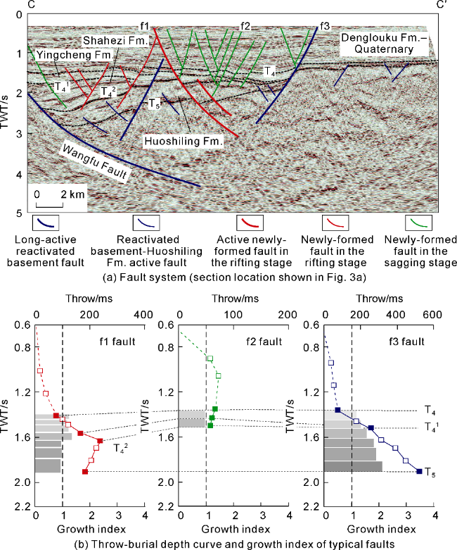
Fig. 4. Fault system section in the Wangfu fault depression, throw-burial depth curve and growth index diagram. |
3.3. Phase/type division of faults
A fault system refers to a series of fault combinations that have genetic connections [41]. Based on the analysis of the characteristics of fault activities, the faults penetrating the T42 reflector in the Wangfu fault depression are classified into five sub-types under three types: long-active reactivated basement faults, active faults in the basement-Huoshiling Formation, newly-formed long-active faults in the rifting stage, newly-formed faults in the rifting stage, and newly-formed faults in the sagging stage (Fig. 5).
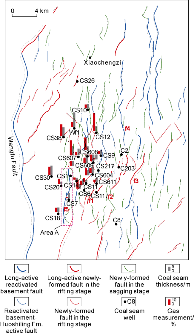
Fig. 5. Division of faults at T42 in the Wangfu fault depression (the regional location in Fig. 1a). |
A reactivated fault refers to the fault that had existed before the sedimentation of the Huoshiling Formation and originated from the pre-existing strike-slip T-rupture. It runs long from north to south, and is usually composed of multiple isolated faults connected together (Fig. 5). According to the period of fault activities, the faults can be further classified into early, middle and late long active faults and active faults of the Huoshiling Formation. Long active faults have good vertical continuity and always maintain a strong activity intensity, and they can serve as boundary faults to control the formation and sedimentation of fault depression, such as the Wangfu Fault. The faults only active within the Huoshiling Formation have straight trajectories, extend relatively far in the basement, and disappear upwards in the Huoshiling Formation (Fig. 4a).
The newly-formed faults of the rifting stage refer to the faults formed during the rifting stage (sedimentary period of the Huoshiling Formation-Yingcheng Formation), mainly trending northeastward, with a small number of transformation faults trending northwestward developed in between (Fig. 5). The scale and extension of the faults are relatively large, and they are orthogonal extension fault formed under the NW-SE stress field. Similarly, based on the period of fault activity, the newly-formed faults can be further classified into middle-to-late long-active faults and active faults in the rifting stage. The long active faults continuously extend upward into the depression layer, serving as bridges and links between various faults and controlling the development and deformation of internal secondary faults. However, the fault activities within the depression layer are weak (Fig. 4).
The newly-formed faults in the sagging stage refer to the faults formed since the sedimentation of the Denglouku Formation. They are small and usually near long active faults. Within the Wangfu fault depression, the faults are mainly NS-striking (Fig. 5).
4. Controls of faults on the enrichment of coal-rock gas
The fault system is a key factor controlling the spatial distribution of coal seams and enrichment of coal-rock gas. Different types of faults represent different controlling effects on coal seams and coal-rock gas. It is found that the long-active reactivated basement faults control the formation and development of fault depression, and thereby control the accumulation of coal seams in the fault depression. The long-active basement and newly-formed faults can not only control the distribution of sedimentary system and coal seams within the fault depression, but also act as potential conductive faults to disrupt the accumulation of coal-rock gas. This paper analyzes the controls of various faults on the development and distribution of coal seams and the preservation conditions for coal-rock gas in terms of fault activity, segmentation and sealability.
4.1. Correlation between fault activity and differential sedimentation of coal seams
The development of coal seams is a fundamental material condition for the enrichment of coal-rock gas. Exploration practice has confirmed that the development degree is positively proportional to the gas logging data of coal-rock gas (Fig. 5), indicating that the potential of coal-rock gas resources is greater. For coal seams in the fault depression layer, the difference in fault activities is a key factor affecting the development degree of coal seams.
4.1.1. Relationship between horizontal extension intensity of faults and cumulative thickness of coal seams
The basement faults in the southern Songliao Basin mainly include three major faults: the pre-existing T-rupture striking nearly SN, the R-shear rupture striking NE, and the R'-shear rupture striking NW. The Wangfu fault depression is jointly controlled by the faults striking NS and NE, with an area of approximately 1 700 km2. The maximum cumulative thickness of coal seams encountered by a single well is about 43 m. However, the fault depression scale controlled by the reactivated long-active basement faults of different orientations and the accumulation degree of coal seams have been still unclear. It is statistically analyzed that the Wangfu fault depression is different from the other five typical coal accumulation fault depressions controlled by different strikes of the basement faults in the surrounding area. According to the fault depression area and cumulative thickness of coal seams encountered by single wells (Fig. 6a), Dehui and Lishu fault depressions controlled by NE- and NNE-striking faults are larger than the Wangfu fault depression and the Fulongquan fault depression controlled by composite faults striking nearly SN and NNE, the Yuxi fault depression controlled by fault striking nearly SN, and the Gudian fault depression controlled by NW-striking faults (Figs. 2b and 6a). The phenomenon is ascribed to that the fault depression area is controlled by the horizontal extension intensity of boundary faults. Under the action of NW-SE extension, the horizontal extension intensity of the NW-NNE-striking faults extending orthogonally is the greatest, followed by the nearly SN-striking faults extending at high dips, and finally the NW-striking fault extending at low dips. Correspondingly, there is a positive correlation between cumulative thickness of coal seams and fault depression area (Fig. 6a). The larger the fault depression area, the larger the cumulative thickness of coal seams. Therefore, within the southern Songliao Basin, the coal seams controlled by the faults striking NE-NNE and nearly SN are the most developed.
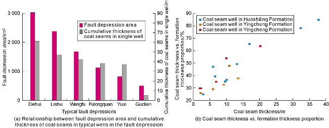
Fig. 6. Correlation between coal seam thickness and fault development for typical wells in Wangfu and adjacent fault depressions [16]. |
4.1.2. Relationship between vertical activity intensity of fault and single-period coal seam thickness
In addition to the influence of sedimentary environment, the vertical activity intensity of the long active basement faults has significant differences in the settlement amplitude of the Wangfu fault depression in different periods. The vertical activity intensity of the fault during the sedimentary period of the Huoshiling Formation was strong, and the fault depression subsidence was large, followed by the Shahezi Formation and the Yingcheng Formation (Figs. 3c, 3d, and 4a). This is highly consistent with the law of the single-period thickness of coal seams within the Wangfu fault depression. This paper statistically analyzes the thickness of single-stage coal seams and the corresponding formation thickness amounting to the fault depression layer in typical wells (Fig. 6b) and finds that there is a positive correlation between the two. That is, the larger the proportion of coal seam formation to the fault depression layer, the thicker the single-stage coal seam, due to the positive correlation between the intensity of fault activities and sedimentary thickness. The areas with strong fault activities usually experienced multiple stages of fault activities and filling processes, resulting in an increase in local settlement rate. The vertical fault activity intensity equilibrates the settlement process by changing the settlement rate and affecting the stability of sedimentary environment. Under balanced settlement, the sedimentary environment remains stable, providing a favorable space for continuous accumulation of coal seams. With the increase of fault activity intensity, the settlement rate accelerates, and the equilibrium settlement condition becomes more stable, thereby to promote the thickening of coal seams. The intensity of fault activity directly controls the thickness difference of coal seams. The stronger the fault activity, the larger the cumulative thickness of coal seams.
4.1.3. Control of boundary faults on filling process and their relationship with accumulation frequency of coal seams
Coal seams in the Wangfu fault depression are almost concentrated in the Huoshiling Formation, with relatively large single-layer thickness, and others are thin and interbedded in the Shahezi Formation and the Yingcheng Formation. This phenomenon is closely related to the long active basement faults reactivated in the early rifting stage when the Huoshiling Formation deposited. In the early rifting stage, the reactivated basement faults significantly controlled the sedimentation on the original ancient landform by a process of "rifting first and then filling" (Fig. 7a). The fault activities created stable and balanced settlement conditions, promoting the concentrated and stable development of coal seams. However, due to the influence of fault segmentation points where sediments entered, the coal-forming environments were different. The water near the basin edge was shallower, and more likely to be a coal-forming environment, so the coal seams are thick. The water near sag centers was deeper, so the coal seams are thin. Furthermore, underdeveloped newly-formed secondary faults and stable structures were conducive to the accumulation of coal seams.
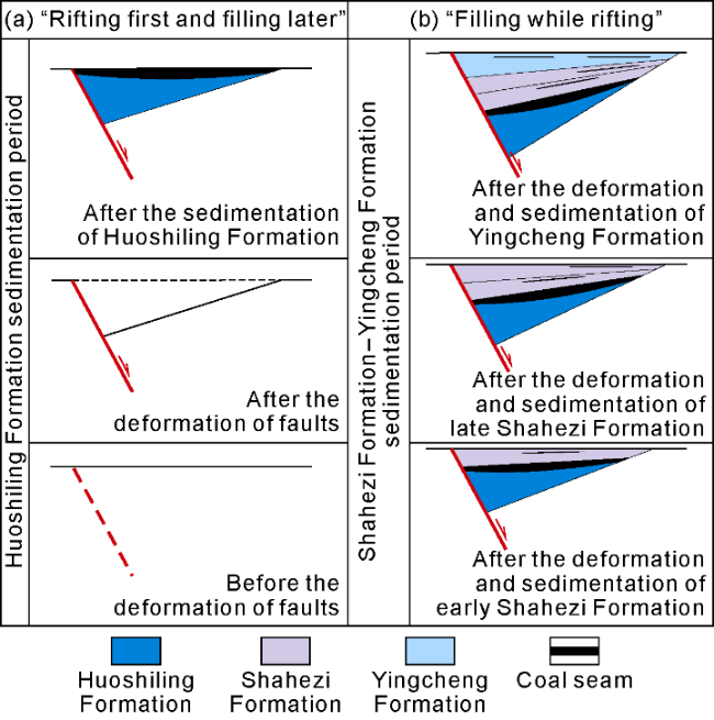
Fig. 7. Schematic tectonic-sedimentary differential evolution models during the rifting period of Wangfu fault depression. |
The Shahezi Formation and the Yingcheng Formation were developed in the early strong and late weak rifting periods, respectively. A "rifting while filling" process (Fig. 7b) kept the basin always in a balanced settlement state. This settlement environment promoted the formation of intermittent coal-forming environments, resulting in the development of interbedded coal seams in multiple layers, and the accumulation frequency of coal seams is higher.
4.2. Impacts of segmentation and lateral throw variation of faults on coal seam distribution
The development characteristics and lithological composition of coal-bearing strata are closely related to the sedimentary environment. Previous studies have shown that the sedimentary facies of coal-bearing strata in China include six types: epeiric sea-barrier coast, epeiric sea-barrier-free coast, delta, river, lacustrine and alluvial fan [4-5]. As the Wangfu fault depression was developed in a continental rift basin, the coal seams were mainly developed in sedimentary environments dominated by delta facies such as floodplains, fluvial marshes, interplain bay marshes and lacustrine and marsh facies.
The faults in the Wangfu fault depression were segmented during the multi-stage evolution process, and adjacent fault sections formed different transition zones through "soft" or "hard" connection in different growth stages. As the western boundary of the Wangfu fault depression, the Wangfu Fault is a reactivated basement fault keeping long active. During the sedimentary period of the Huoshiling Formation, an abrupt displacement point at Line L1340 divided the Wangfu Fault into two sections (Fig. 8). "Hard connection" of the Wangfu Fault at the division points controls differential activities in different segments, resulting in the formation of transitional zones. In the eastern part of the Wangfu fault depression, the lateral isotropic normal faults f3 and f4 form transition slopes as they approach each other. The transition zones not only control where sediments come into the lacustrine basin [42], but also affect the spatial distribution of sedimentary facies (Fig. 3a), ultimately determining the favorable coal-forming environment within the fault depression. Fault segmentation plays a crucial role in the plane distribution of coal seams. Based on the two interactions between faults, two source-controlling models were formed within the Wangfu fault depression (Fig. 3a). The first model is "segmentation points controlling differential fault activity", characterized by a small displacement at the "hard connection", so it’s easy to form a low-value area of transverse syncline terrain, which is conducive to transporting sediments. The second model is "lateral strike slope", i.e., a transform slope formed by multiple lateral isotropic normal faults at the "soft connection" in the east part. It is favorable for sediment migration.
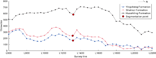
Fig. 8. Throw distribution of fault depression layers in the Wangfu Fault. |
In the early sedimentation, the transform zones on both sides controlled source inflow into the lacustrine basin, ensuring sufficient sediment supply. The fault segmentation point was a passage for sediment into the lacustrine basin, and a point at which fault activities were less intense. At such positions, fault control induced frequent abovewater and underwater swamp environments, which were conducive to the accumulation of coal seams. In addition, with abundant basal igneous rocks on the eastern side of the Wangfu fault depression [43], when coal seam accumulated, magma intrusion from volcanic eruptions accelerated the sedimentary-filling process in the fault depression area, and stable settlement conditions provided a favorable sedimentary environment for the accumulation of coal seams. Fault segmentation and the intrusion location of igneous rocks jointly controlled the favorable accumulation of coal seams.
4.3. Fault sealing and preservation of coal-rock gas
The fault communicating coal seams with surface is directly responsible for the leakage and escape of coal-rock gas. Evaluation of vertical fault sealing is important for risk assessment of coal-rock gas exploration and development. The stronger the vertical sealing capability, the more difficult it is for coal-rock gas to migrate vertically along the fault, and the more conducive it is to the preservation of coal-rock gas.
Evaluation of fault vertical sealing mainly includes four steps. First, it is necessary to screen gas source faults. In a broad sense, faults that connect source rocks with reservoirs and are active during gas accumulation period are called gas source faults [44]. In the Wangfu fault depression, the long-active reactivated basement faults and the newly-formed faults are gas source faults (Fig. 5). Second, it is necessary to select an effective evaluation method. The roofs and floors of the coal seams in the Wangfu fault depression are at 2 000 m to 3 000 m where the formation suffered from brittle-ductile deformation. The shale smear coefficient (SSF) was used to calculate the fault vertical sealing [45]. Then the evaluation criteria were established. The throws of gas source faults at T42 and the thickness of coal seam roofs were utilized to establish a throw-roof thickness chart. And based on the gas measurements of 29 wells in the Wangfu fault depression, the calculated critical value of the fault vertical sealing is 1.1 (Fig. 9). When SSF > 1.1, the gas content is lower than 13 m3/t, indicating that faults are open vertically and coal-rock gas is escaping from deep to shallow layers. When SSF ≤ 1.1, the gas content is higher than 13 m3/t, indicating faults are closed vertically, and coal-rock gas is blocked by coal seam roofs. Finally, the above standards were applied to evaluate the vertical sealing performance of the gas source faults within the main coal area in the Wangfu fault depression. The results show that the SSF values are all lower than the critical value of 1.1, indicating strong vertical sealing performance. Only in the south and the periphery of the main coal area, some faults’ SSF values are higher than the critical value of 1.1 in the middle section, indicating a poor sealing performance and a risk of coal-rock gas leakage (Figs. 10 and 11).
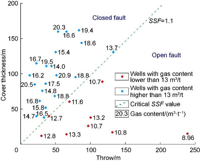
Fig. 9. Calibration of critical value of the fault vertical sealing in the Wangfu fault depression. |
Taking fault f5 as an example, the SSF value was calculated by the fault throw at T42 and the thickness of the coal seam roof to analyze the vertical sealing capability (Fig. 10). The result shows that the SSF in the middle of fault f1 is higher than 1.1, and the SSF at the end is less and equal to 1.1, indicating that the middle is not sealed. The gas contents in wells CS20 and CS7 located in the middle of fault f1 are low. However, fault f1 gradually transitions to a closed state towards both ends. Well CS1 is within the closed range and has a high gas content.
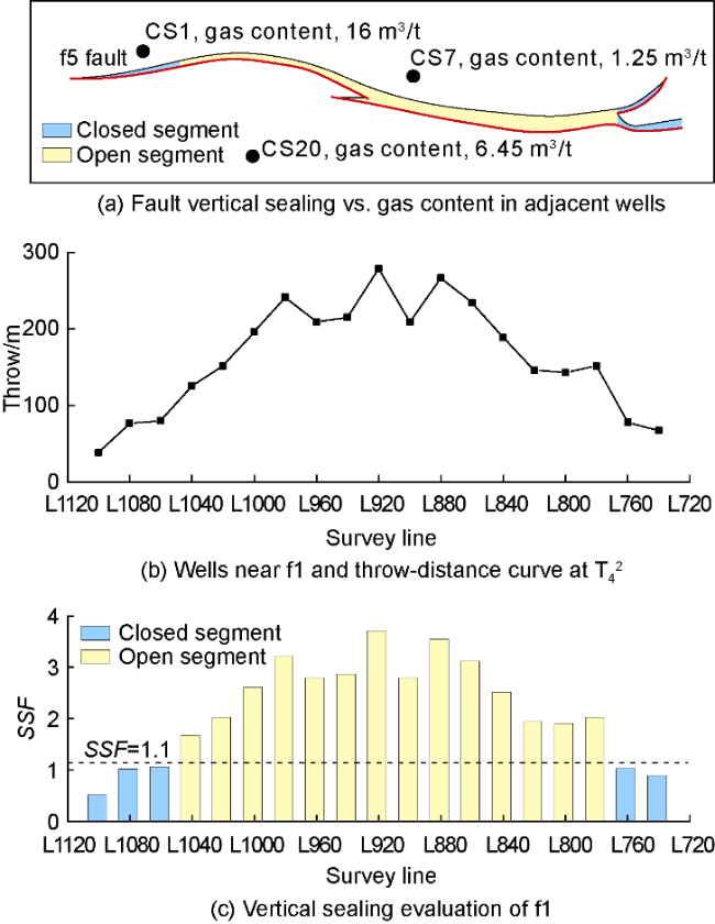
Fig. 10. Evaluation of vertical sealing of fault f5 in the Wangfu fault depression (fault location shown in Zone A in Fig. 5a). |
4.4. Fault-controlled model for coal-rock gas accumulation
Based on a comprehensive analysis of factors such as fault activity, segmentation, sealability, sedimentary environment, volcanic eruption, coal seam enrichment layers, coal seam thickness, number of coal seams, and gas content, a fault-controlled model for deep coal-rock gas accumulation in the Wangfu fault depression basin was established (Fig. 12). The Wangfu fault depression is evidently characterized by extremely-developed long active faults with high activity intensity. The distribution of coal seams and occurrence of coal-rock gas are all controlled by faults. The Wangfu Fault not only controls the subsidence amplitude of the fault depression in every period but also affects the sedimentary-filling process. Appropriate coupling of structure and deposition is conducive to the formation of a coal-forming environment. However, the intrusion of igneous rocks accelerates the filling effect of sediments. The two jointly determine the dominant accumulation location of coal seams. Therefore, a set of thick to extremely thick coal seams is concentrated at the top of the Huoshiling Formation in the Wangfu fault depression, while thin coal seams are interbedded in the Shahezi Formation. Faults within the depression not only affect the local sedimentary environment, but also dominate whether coal-rock gas can be enriched in the deep layers. By analyzing the vertical sealing property, it is found that in areas with well-developed coal seams, the gas content near vertical closed faults is high, while that near vertical leaky faults is significantly low.
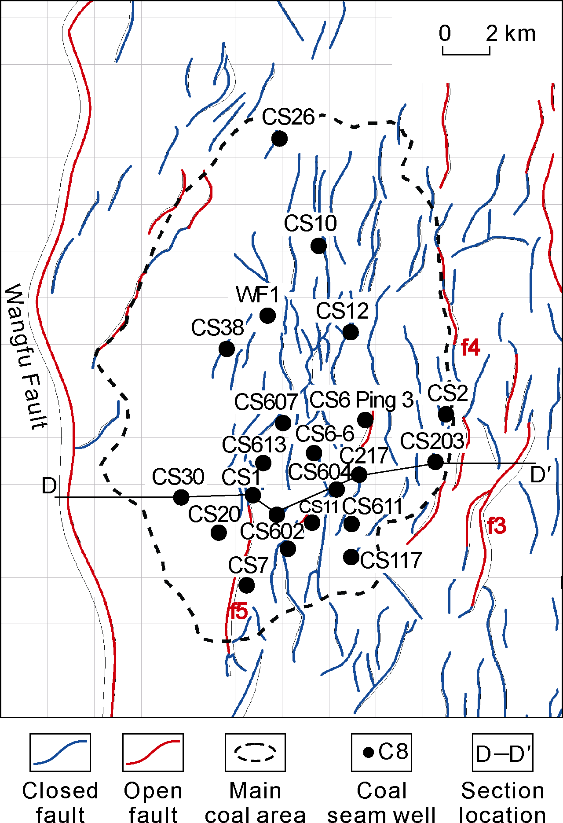
Fig. 11. Evaluation of vertical sealing of faults in the Wangfu fault depression. |
Fig. 12. Coal-rock gas accumulation model in the Wangfu fault depression (the section position in Fig. 11). |
5. Conclusions
The multi-strike faults at the basement of the Songliao Basin are originated from the reactivation of strike-slip derivative structures induced by the sinistral strike-slip activity of the Yilan-Yitong fault zone from the Late Jurassic to the Early Cretaceous, specifically including the NE-NNE-striking R-shear rupture, the NW-striking R'-shear rupture and the nearly-SN-striking T-rupture. The Wangfu fault depression is an asymmetrical graben controlled by the reactivated T-rupture. It develops coal seams and five subtypes of faults under three types: long- active reactivated basement fault, active basement-Huoshiling Formation fault, long-active newly-formed fault during the rifting period, newly-formed fault during the rifting period and newly-formed fault during the sagging period.
Fault activities control the vertical coal accumulation in the fault depression. The horizontal extension intensity of faults is positively correlated with the thickness of coal seams. The horizontal extension intensity of the NE-NNE- striking fault with orthogonal extension is the greatest, which controls the accumulation of thick coal seams. The intensity of the vertical fault activity regulates the settlement rate. Intense fault activity accelerates the settlement rate, creates stable and equilibrium settlement conditions, and promotes the thickening of coal seams. The sedimentary-filling model also determines the accumulation frequency of coal seams. The "rifting first and filling late" model featured by balanced settlement controls the concentrated development of thick coal seams in the Huoshiling Formation. The "rifting while filling" model represented by frequent balanced settlement controls the interbedded development of coal seams in the Shahezi Formation and the Yingcheng Formation, resulting in a high accumulation frequency of coal seams.
Fault segmentation and the intrusion of igneous rocks jointly determine the dominant accumulation locations of coal seams on plane. Different growth stages generated two source-controlling models of "differential fault activity segments" and "a lateral strike slope", which control the inlet and path for sediments into the lacustrine basin. The filling effect produced by the intrusion of igneous rocks accelerates the sedimentary-filling process. The stable settlement conditions provide a favorable sedimentary environment for the accumulation of coal seams.
The vertical sealing capacity of faults directly affects the preservation conditions for coal-rock gas. The critical SSF at the roof of coal seam is approximately 1.1. The vertical sealing performance in the main coal area is good, and conducive to the effective preservation of coal-rock gas.
By comprehensively analyzing factors such as fault activity, segmentation, sealing performance, sedimentary environment, volcanic invasions or eruptions, coal enrichment layers, thickness, quantity and gas content of coal seams, a fault-controlled accumulation model for deep coal-rock gas in the Wangfu fault depression was established. The activity, segmentation and sealing of faults play a decisive role in the accumulation, distribution and preservation of coal-rock gas, and they are basic parameters for exploration of deep coal-rock gas.