

Introduction
As an important field of global oil and gas exploration, fold-thrust belts in foreland basins have always played a crucial role in the study of structural deformation mechanisms and resource enrichment laws [1]. This type of complex structural system developed at plate boundaries is characterized by multiple periods and layers of thrust and fault related folds. The spatiotemporal differentiation of its structural styles directly controls the spatial configuration of oil and gas accumulation systems. Located in the southern margin of the Junggar Basin of the Central Asian orogenic belt (referred to as SMJB for short), it is a typical foreland fold-thrust belt in China, which has undergone multi-stage structural superposition and reformation, forming a composite deformation system interwoven by the basement involved thick skinned structure and the cover detachment thin skinned structure [2]. In this area, the surface oil and gas seedlings are widely distributed, and the unique "multi-story building" type reservoir-forming structure is developed [3]. After 100 years of exploration since the 1930s, Dushanzi, Khorgos, Manas and other medium and shallow oil and gas fields have been successively discovered. In recent years, high-risk exploration wells such as GT1 and TW1 have achieved high-yield breakthroughs in the Lower Cretaceous and Jurassic formations of in lower combination. However, the overall exploration efficiency has not yet achieved a large-scale improvement, and the approved reserves ratio of deep target areas is still insufficient.
The previous studies have shown that the western, middle, and eastern sections of SMJB are controlled by differentiated basement features and detachment layer combinations, forming distinct structural styles such as progressive thrust and multiple thrust [4]. However, there is still a lack of systematic understanding of their dynamic connections and spatiotemporal transformation laws. More importantly, the common problems in deep target areas, such as unclear structural stacking relationships and disputes over identifying detachment layers, seriously constrain the effectiveness evaluation of structural traps and the selection of drilling targets.
This article utilizes the latest deployment of broadband, wide azimuth, high-density (two-wide and one-high) 3D seismic, high-precision gravity-magnetism, and drilling data to dissect the deformation characteristics of typical structural zones, with a focus on revealing: (1) The control mechanism of ancient structural frameworks on current structural zoning; (2) The constrains of the spatial distribution of key detachment layers on the deformation style; (3) The reconstruction effect of structural-sedimentary coupling process on oil and gas reservoir-forming elements. The research results will provide theoretical support for establishing a structural interpretation model that is in line with geological reality, and have important practical value in guiding the optimization of deep strategic breakthrough zones.
1. Geological setting
The SMJB foreland fold-thrust belt is located in the northern foot of the North Tianshan Mountains. The same as most foreland thrust belts, the structural deformation in SMJB has the structural distribution characteristics of "north-south zoning, east-west segmentation". From west to east, four secondary structural units are developed, namely Sikeshu Sag in the west, Huomatu Anticline and Qigu Fault Fold Belt in the middle, and Fukang Fault Belt in the east [4-6] (Fig. 1).
Fig. 1. Structural zoning map of the southern margin of Junggar Basin. |
In SMJB, Permian, Triassic, Jurassic, Cretaceous, Paleogene and Neogene are developed from bottom to top on a dual basement of pre-Carboniferous folds and pre-Cambrian metamorphic crystallization. Among them, the erosion of the Upper Jurassic is obvious, resulting in local stratigraphic absence; and there are obvious angular unconformities between the Cretaceous and Jurassic, and between the Permian and underlying strata. The mudstone and coal measure of the Jurassic Shuixigou Group, the mudstone layers of the Cretaceous Tugulu Group, and the mudstone layers of the Paleogene Anjihaihe Formation are regional cap rock, source rock layers, and important detachment layers [7-8] (Fig. 2). They control the formation of four layers of structures, including upper, middle, lower, and deep layers, as well as upper, middle, and lower sets of reservoir combinations. The deformation patterns of different structural layers have significant differences and are stacked vertically, presenting a layered deformation characteristic [7,9].
Fig. 2. Comprehensive histogram of strata in the southern margin of Junggar Basin. |
SMJB has undergone multiple tectonic movements, and its tectonic evolution can be summarized into three major stages: In the early stage (Carboniferous- Early Permian), it was controlled by the continental margin activation after the closure of the ancient Asian Ocean, and experienced the accretion of the continental crust, the reduction of the oceanic crust to the development of extensional rifts, forming a coexistence system of residual ocean basins and deep-water lake basins. In the middle stage (Middle-Late Permian- Cretaceous), it transitioned into an inland depression stage, accompanied by the uplifting of Chemo Low Uplift and basin differentiation caused by the northwest-west trending compression in Jurassic, and the overall subsidence and contraction in Cretaceous. In the late stage (Paleogene-Quaternary), due to the long- range collision effect between the Indian and Eurasian plates, the strong thrusting of the North Tianshan Mountains coupled with basin tilting and subsidence, ultimately forming a typical Cenozoic intracontinental foreland basin [5-6] (Fig. 2).
2. Structural characteristics and main controlling factors
The research on deformation mechanism and structural characteristics of SMJB by predecessors has a long history, and has initially formed the understanding that the ancient structural morphology and the longitudinal and transverse distribution of detachment layers control the deformation [3-4,10]. However, due to the influence of drilling and seismic data quality, previous researchers only identified the upper and lower sets of detachment layers. Simulation experiments on detachment deformation are mostly setting corresponding evolution models based on simple dual detachment structures and wedge-shaped thrust, and the research is mainly focused on single structural units in SMJB, lacking systematic characterization of the ancient structural morphology and detachment layer distribution, making it difficult to solve the complex phenomenon of oil and gas accumulation in this area. With the large-scale implementation of the "two-wide and one-high" 3D seismic and the deployment of deep drilling, it provides a good opportunity for further research and understanding of the structural characteristics and main controlling factors of deformation in SMJB.
2.1. Structural development
Although previous scholars have proposed the concept of "multi-story building" structure [2-5,11], it tends to describe phenomena and has not yet established a universally applicable explanatory model of three detachment structure in the region. The poor quality of early seismic data has limited our understanding of deep structures, and the division methods of deformation sequences and deformation characteristics of each structural segment still need to be further systematically sorted out. Based on newly collected multiple 3D seismic data, this paper conducts overall deconstruction of the structural deformation sequence and description of structural features of SMJB in segments, and establishes a typical feature model.
2.1.1. Structural characteristics of the western segment
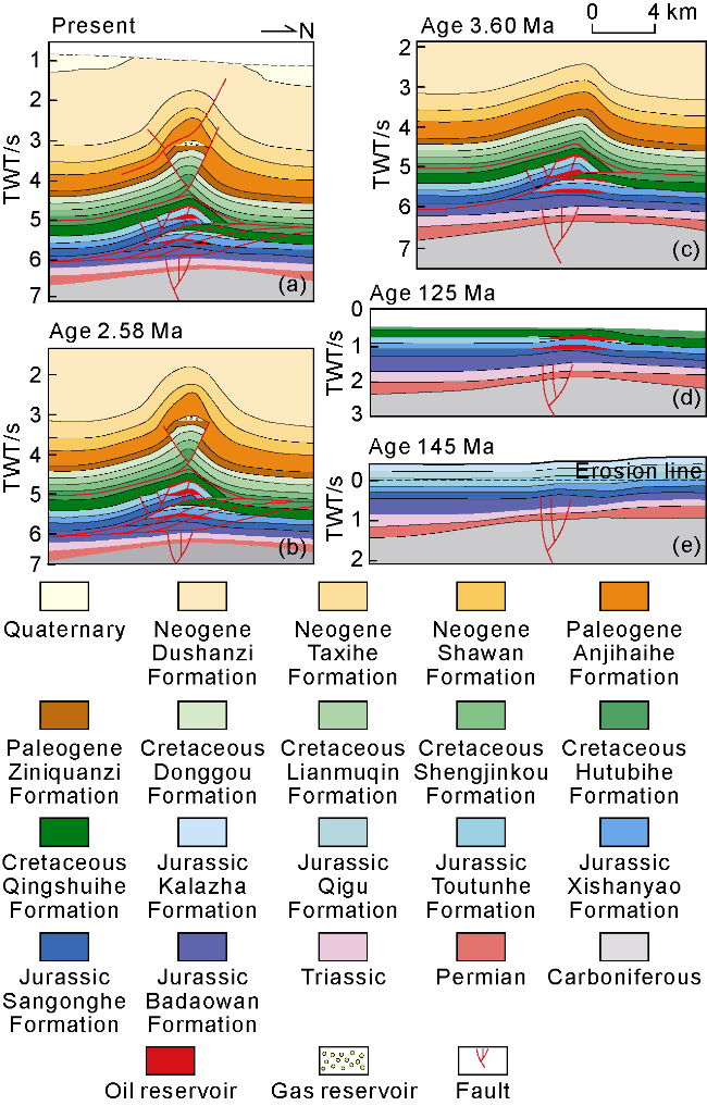
The western segment is basically the entire Sikeshu sag area (Fig. 1). The basement of the Sikeshu sag is mainly composed of Devonian-Carboniferous marine-continental clastic rock formations and late volcanic formations. Since the Permian, the Sikeshu sag has undergone tectonic movements from the Hercynian-Indosinian, Yanshanian, and Himalayan periods [9]. During the Hercynian-Indosinian period, two ancient structures were developed: the southern Gaoquan and the northern Chepaizi. The ancient structures of the Yanshanian period continued to uplift, with a series of northwest trending transpression-strike-slip faults developed on the uplift flank. The Himalayan period was influenced by two sets of detachment layers in Jurassic and Paleogene, resulting in the development of dual detachment and thrust (Figs. 3 and 4a).
Fig. 3. Outline map of thrust belt and trap in the Jurassic top of Junggar Basin. |
Fig. 4. North-south trending seismic-geological structure interpretation of typical area in the southern margin of Junggar Basin (see Fig. 1 for the section location). Q—Quaternary; N2—Pliocene Series; N1—Miocene Series; E—Paleogene; K— Cretaceous; J3—Upper Jurassic; J2—Middle Jurassic; J1—Lower Jurassic; J1b—Badaowan Formation; T—Triassic; T1— Lower Triassic; P—Permian; P1—Lower Permian; P2—Middle Permian; P3—Upper Permian; C—Carboniferous. |
The current form of the western segment is characterized by a structural pattern of "two highs sandwiching one sag", with two rows of structural belts developed across the sag. The southern Gaoquan structural belt is influenced by early paleo-highs and late detachment and thrust, forming multiple right lateral and right step fault nose-fault anticline structures such as Gaoquan and Gaoquan South. The northern Aika structural belt is controlled by early Chepaizi high and late thrust and overturning, forming multiple right lateral and left step positive structures represented by Kayindike, Xihu, Dushanzi, and Dunan on the southern wing of the uplift (Fig. 3).
2.1.2. Structural characteristics of the mid segment
The middle segment mainly includes two secondary structural units: the Huomatu Anticline Belt and the Qigu Fault Fold Belt (Fig. 1), which underwent reconstruction of tectonic movements during the Hercynian-Indosinian, Yanshanian, and Himalayan periods. The Hercynian-Indosinian period was characterized by alternating uplifts and sags during the period of fault-depression transition, and the embryonic form of the Huomatu Structural Belt was developed in the middle of the anticline belt. The Yanshanian period exhibited transpression characteristics, with a series of strike-slip faults developed near the Chemo Low Uplift and Huomatou Structural Belt. During late Yanshanian-Himalayan period, 3 stages of detachment and thrust structures were developed [9], forming a structural style of vertical multi-stage structural superposition (Fig. 4b).
Currently, there are 8 rows of structural belts developing from south to north, namely the Qigu structural Belt, Dongwan Structural Belt, Huomatu Structural Belt, Du’an structural Belt, Tudong structural Belt, Hutubi structural Belt, Fangcaohu Structural Belt, and Sangjiaqu Structural Belt (Figs. 3 and 4b). (1) The Qigu structural Belt is controlled by multi-period uplift, with the development of the hanging wall thrust belt and the footwall overthrust belt. The footwall overthrust belt exhibits strong tectonic activity and complex deformation, with the development of multiple left lateral and left step positive structures. (2) The Dongwan Structural Belt is a row of positive structural belts within the sag area, and the early Himalayan tectonic activity within the belt was relatively weak. Controlled by differential transpression of the north- south structural belts, it horizontally formed a left step structural cluster distributed in an en echelon oblique manner in multiple belts such as Tianwan and Tianwan West. Vertically, it manifests as a structural style of deep anticlinal structure superimposed with syncline structure formed by long-distance detachment and thrust in middle-shallow layers. (3) The Huomatu Structural Belt is a large anticline belt formed by superposition of 3 stages of detachment and thrust structure under the background of pre-existing ancient high (Fig. 4b), which is shown horizontally as multiple overlapping faulted anticline targets similar to "tomatoes on sticks", and vertically as a "triple-story building" structural style of superposition of the fault bend fold in lower combination and two stages of fault propagation folds in the middle and upper combinations. Overlaying the structural deformation layers below the Jurassic coal measure detachment layer can form a 4-layered complex structural deformation sequence ("four-story building"). The vertical deformation sequence of this belt is relatively complex. Based on preexisting structural physics simulation experiments and equilibrium section verification [12-13], deep structures were formed during the Late Yanshanian-Early Himalayan, middle structures were formed during the middle Himalayan period, and shallow structures were formed during the late Himalayan period. (4) The Du’an Structural Belt is jointly controlled by Matu Low Uplift belt and Chemo Low Uplift belt. It is similar to Huomatu structural belt in the horizontal direction and has a "two-story building" structural style of superposition of the fault bend fold in lower combination and the fault propagation fold in middle and upper combinations in the vertical direction, where two stages of structures underwent strong deformation. (5) The Tudong Structural Belt is located at the pitching end of the early uplift, with 5 anticline targets developed horizontally. The anticline in lower combination is complete in shape, forming a three-layer structure similar to the Tugulu anticline in the vertical direction, but the overall deformation strength of 3 sets of structural layers is weak, and the deep and shallow faults are not overlapped. (6) The Hutubi Structural Belt is controlled by the early Low Uplift background. The horizontal main body is multiple oblique-lined positive structures such as Huxi, Huzhong and Hudong, with the superposition of the fault bend fold in lower combination and the fault propagation fold in middle combination vertically. The overall structural activity is weak. The lower structural layer is a complete anticline with good preservation conditions. (7) The Fangcaohu Structural Belt is located in the southern foreland slope area (Fig. 4b). Multiple rows of forward-propagating fault blocks and fault nose clusters formed by late long-distance detachment and thrusting, and the lateral structural targets are distributed in a right lateral and right step oblique alignment. Vertically, the lower structural layer is jointly controlled by strike-slip faults in Yanshanian period and thrust faults in Himalayan period, and large-scale fault block is developed. (8) Sangjiaqu Structural Belt is located in the front uplift of the Himalayan foreland basin, with an early Low Uplift background (Fig. 4b), far from the reconstruction of the Himalayan movement, and mainly develops fault block structures formed by the transpression-strike-slip in the Yanshanian period.
2.1.3. Structural characteristics of the eastern segment
On the whole, it is mainly affected by the northward thrust of the Bogda Mountain structural system. It mainly manifests as the superposition of the high-angle basement-involved structure in the footwall and the detachment and thrust structure in the hanging wall (Fig. 4c), which shows the "arc" thrust from south to north. There are certain differences between the eastern and western structures within the structural belt. The vicinity of Well FK1 is dominated by Jurassic thin-skinned thrust nappe, with multiple fault noses distributed in an en echelon manner in the hanging wall and multiple overlapping imbricate fault block targets in the footwall (Fig. 3). The hanging wall is strongly thrust with a relatively narrow local fault nose, and the footwall is developed with thrust fault anticline. The hanging wall of the eastern Jinan area is relatively wide, and develops relatively stable structural targets, while the footwall develops thrust fault nose and fault block targets (Fig. 4c).
2.2. Structural deformation mechanism and main controlling factors
In the process of tectonic evolution in SMJB, the control of pre-existing paleo-structures on late structural deformation is very significant. The basement morphology of paleo-structures and the distribution of pre-existing faults provide an important structural background for the occurrence of late detachment-thrust deformation [11]. First, the paleo-structures and their distribution pattern (paleogeomorphology) control the thickness and spatial distribution of the late detachment layer. For example, Jurassic coal seam and Paleogene gypsum mudstone layer are prone to bedding detachment deformation under the action of compressive stress due to their high plasticity. The distribution range and thickness of these strata directly determine the range and strength of the detachment-thrust deformation, which is the key factor controlling the deformation process [7,12]. Second, the paleo-structures also have an important influence on the distribution and change of deformation space. The variation of deformation space changes the position of stress concentration response, forcing the stress to focus on the weak zones such as pre-existing faults and folds, and the faults are prone to reactivation, which further promotes the development of detachment nappe deformation [11]. This paper mainly analyzes the control of Hercynian-Indosinian and Yanshanian paleo-structures on the later deformation and the distribution of 3 sets of detachment layers.
2.2.1. Distribution and evolution of paleo-structures
The residual gravity and magnetism data reveal that the Indosinian paleo-structures in SMJB is mainly characterized by a structure pattern with 5 highs and 4 sags (Fig. 5). For the convenience of positioning, parts of unpenetrated exploration wells are marked in the figure. The 5 highs are Gaoquan Low uplift, Chepaizi high, Mosuowan-Baijiahai high, Santai high and Matu low Uplift, and the 4 sags are Sikeshu sag, Shawan sag, Qigu sag and Fukang sag. Recent sandbox simulation experiments and discrete element numerical simulation experiments show that the pre-existing structures basically control the late structural deformation mode (inherited superposition) and vertical superposition style [13-14].
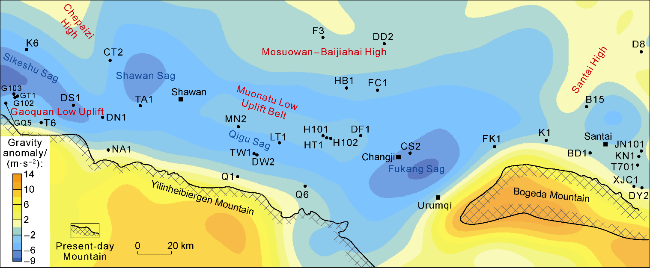
Fig. 5. Distribution map of paleo-structural framework before Jurassic sedimentation in the southern margin of Junggar Basin (residual gravity delamination at the end of the Indosinian period). |
The Jurassic paleogeomorphology clearly reflects the successive development characteristics of Gaoquan Low Uplift, Chepaizi High and Santai High. The Matu Low Uplift in the middle gradually disappeared, and the Mosuowan-Baijiahai High in the north area was connected with Chepaizi High due to the leveling of Shawan Sag, further integrating to form the largest Chemo Low Uplift in the Yanshanian period (Fig. 6). Overall, the Yanshanian paleo-structural setting basically controlled the Himalayan lateral deformation space. The western segment is controlled by Gaoquan Low Uplift and Chepaizi High. The north-south deformation space in the basin is relatively narrow, and the deformation distance in the Late Himalayan period is within 30 km. The Chemo Low Uplift belt in the north of the middle segment also controls the deformation space of the Himalayan detachment nappe. The scale of the high in this period directly affects the distance of the stress transmission of the detachment nappe. On the plane, the scale of the high is the largest in the middle of the low uplift, followed by the west, and the east is the gentlest. The structural deformation space changes accordingly, with narrow in the middle (33 km), medium in the west (40 km), and the widest in the east (97 km). In the eastern segment, the Santai uplift is successively developed, which makes the Himalayan north- south trending deformation space in the basin relatively narrow, mainly characterized by high-angle nappe and vertical deformation in the piedmont Permian.
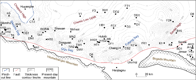
Fig. 6. Thickness restoration map of the Middle-Upper Jurassic in the southern margin of Junggar Basin. |
2.2.2. Distribution of detachment layers
The property and spatial distribution of detachment layers have a far-reaching control on the style, strength and direction of regional structural deformation [12,14]. Affected by the poor imaging quality of early seismic data, Yu et al. [5,11] identified 2 sets of detachment layers (Jurassic Shuixigou Group and Paleogene Anjihaihe Formation) in local area without understanding of regional exploration wells. It is necessary to further systematically characterize the distribution of the entire detachment layers in SMJB.
Based on the high-density 3D seismic data and the analysis results of new drilling wells, this paper reviews the detachment layer and believes that 3 sets of plastic layers, Jurassic Shuixigou Group (J1-2sh), Cretaceous Tugulu Group (K1tg) and Paleogene Anjihaihe Formation (E2-3a), are developed from bottom to top in SMJB area (Fig. 7).
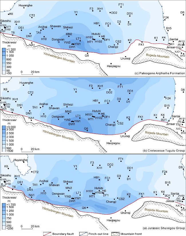
Fig. 7. Plane distribution of 3 sets of Mesozoic-Cenozoic detachment layers in the southern margin of Junggar Basin. |
The Jurassic Shuixigou Group is a deep detachment layer in SMJB, which is mainly developed in the Badaowan Formation of Lower Jurassic and Xishanyao Formation of Middle Jurassic. The lithology is mainly gray-black mudstone interbedded with coal seams. The sedimentary center of this set of detachment layer is located in front of Yilinheibiergen Mountain (Fig. 7a), which is distributed in an E-W-trending strip. In addition to Chepaizi High, it is widely developed from Well GT1 in the west to Well JN1 in the East, with an average thickness of about 1 000 m.
The Cretaceous Tugulu Group detachment layer is a detachment layer in the middle of SMJB and its lithology includes the interbedding of brow-gray fine sandstone, siltstone and gray-brown mudstone, silty mudstone. Whether this set of detachment layer exists or not has been controversial. The newly acquired 3D seismic data in recent years have a high signal-to-noise ratio, which clearly reflects the existence of detachment surfaces within the Cretaceous. Taking Hutubi area as an example (Fig. 4b), the seismic data clearly reveals the development of Yanshanian transpressional or strike-slip faults (blue) and Himalayan thrust detachment faults (red). The Himalayan thrust detachment faults converges and disappears in the mudstone at the bottom of the Cretaceous Hutubihe Formation. The dip angle of the fault plane was relatively gentle, and the thickness of the anticline core is significantly thickened due to stratigraphic repetition, which further confirms the existence of the Cretaceous internal detachment surface. From the perspective of plane distribution characteristics, the thickness of the western and eastern segments of the Cretaceous Tugulu Group is relatively thin, and the thickness of the middle segment mainly ranges from 2 000 m to 3 000 m (Fig. 7b).
The Paleogene Anjihaihe Formation detachment layer belongs to the shallow detachment layer in SMJB, and the ductile rock layer is mainly dark gray mudstone. The sedimentary center in the region is located in Qigu Sag, rapidly thinning to Sikeshu Sag in the west and developing to the basin center in the south, with a maximum thickness of 1 500 m and an average thickness of 600-800 m (Fig. 7c).
Among the 3 sets of detachment layers, the Jurassic detachment layer has medium thickness, which has the smallest internal friction strength and good detachment capacity due to the presence of coal seams, making it the main detachment deformation layer. Although the thickness of the detachment layer is mainly concentrated in the middle segment, due to the large thickness of the overlying strata and the large vertical breakthrough pressure in the middle segment, the relatively weak fault bend fold deformation is dominantly developed, with the lateral superposition of forward spreading thrust structures. Although the thickness of Jurassic detachment layer in the eastern segment is relatively thin, the overlying strata are also relatively thin, and the lateral detachment nappe distance is large, which is dominated by fault propagation fold deformation, forming a large-scale thrust structure (Fig. 4c). The thickness of Cretaceous detachment layer is the largest, and the overlying strata in the whole area are of medium thickness, which inhibits its detachment capacity. At the same time, due to the existence of sandstone interlayer, its internal friction strength is the largest, and it has the weakest detachment capacity, which is mainly manifested as local detachment of the main structure or a vertical stress transfer interface, and as large-scale thin-skinned thrust nappe only in the middle segment (Fig. 4b, the Cretaceous top faults in Hutubi structural belt). Although the thickness of the Paleogene detachment layer is the thinnest, and its overlying strata are also the thinnest, the internal friction strength of the overall detachment layer is moderate, and it is mainly manifested as thin-skinned thrust nappe structure in the west-middle segment.
2.2.3. Control factors
Based on the sandbox simulation experiment and discrete element numerical simulation technology, multiple comparative experiments are designed on the capacity and distribution of 3 sets of detachment layers under different paleo-structure conditions [13-14]. By comparing the experimental results with the actual seismic sections, it is believed that the paleo-structure controls the lateral sedimentary distribution and thickness change of sedimentary strata, and indirectly controls the intensity of detachment deformation. The large-scale paleo-high controls the deformation space and the position of deformation development, that is, the early (Indosinian) paleo-high divides SMJB into western, middle and eastern segments, while the late (Yanshanian) secondary low uplifts control the horizontal belt arrangement (Figs. 3, 5, 6). 3 sets of detachment layers control four-layer composite structural deformation sequences ("four-story building structure") in the upper, middle, lower and deep layers. The structural characteristics of each segment are quite different. 4 sets of structural layers are mainly developed in the middle segment, 3 sets of structural layers are mainly developed in the west segment, and only 2 sets of structural layers are developed in the east segment. The internal friction coefficient and thickness jointly control the transmission capacity of lateral deformation. The lateral displacement is the main deformation in the thick detachment layer area, while the vertical displacement is the main deformation in the thin detachment layer area.
3. Hydrocarbon accumulation and deep hydrocarbon exploration direction
Due to the comprehensive control of multi-stage paleo-structures and multiple sets of plastic detachment layers in SMJB, the vertical structural characteristics are obviously differentiated, which leads to the vertical division of multiple reservoir and cap combinations [15-18] (Fig. 2). Restricted by the exploration conditions and the delineation of complex structures in the early stage, the study was mainly carried out on the middle and upper reservoir forming combinations. Due to poor preservation conditions and unsatisfactory drilling results in the upper combination, relatively efficient gas fields such as Hutubi and Manas with relatively developed structures and moderate preservation conditions in the middle combination are important and secondary exploratory strata for the next high-efficiency exploration [15-21]. Since the “14th Five-Year Plan”, with the continuous progress of geophysical exploration technology, the seismic imaging quality and trap confirmation of the lower combination have been improved, which has promoted the major breakthroughs of wells GT1, HT1 and TW1 in the lower combination, and revealed that the lower combination has the conditions for high-yield oil and gas accumulation. At the same time, the drilling results reveal that at this stage, a new round of reservoir re-recognition with "hydrocarbon source rock distribution and trap preservation" as the core still needs to be carried on, so as to provide the basis for the optimization evaluation of exploration zones and evaluation of targets in the lower combination. Because of the good reservoirs and good caprocks in this area, this paper will not make a detailed description and mainly expounds the two key factors controlling oil and gas accumulation: hydrocarbon source supply and late structural reconstruction.
3.1. Development of main source rocks
As an important area of oil and gas exploration in Junggar Basin, the distribution and evolution of hydrocarbon source rocks in SMJB are of key significance for resource potential evaluation. Exploration research shows that 5 sets of source rocks, Permian, Triassic, Jurassic, Cretaceous and Paleogene, are developed in SMJB[15]. This paper focuses on the Jurassic and Permian source rocks, through multi-disciplinary data fusion and fine characterization, the geochemical characteristics, spatial distribution and hydrocarbon generation evolution model are systematically revealed, providing an important basis for deepening the understanding of hydrocarbon accumulation in SMJB.
3.1.1. Jurassic source rocks
Jurassic source rocks are the main source rocks in the SMJB thrust belt, and the Lower Jurassic Badaowan Formation, Sangonghe Formation and Middle Jurassic Xishanyao Formation are the core development horizons. The lithology is mainly dark mudstone and coal, and the organic matter abundance of coal is significantly dominant: the average content of total organic carbon (TOC) of coal is 60.69% (the highest is 84.20%) (Table 1), and the average hydrocarbon generation potential (S1+S2) is 19.06 mg/g, which is much higher than that of mudstone (the averages of TOC and (S1+S2) are 1.60% and 1.92 mg/g, respectively) [22-23]. Kerogen analysis shows that the organic matter types are mainly Type III and Type II2, and the hydrogen and carbon atomic ratio is generally less than 1.0, indicating the dominant contribution of terrestrial higher plants [22-23].
Table 1. Organic matter abundance statistics of Jurassic source rocks in SMJB |
| Formation | Lithology | TOC/% | (S1+S2)/(mg•g-1) | Chloroform bitumen “A”/% | Total hydrocarbon /% |
|---|---|---|---|---|---|
| Xishanyao | Mudstone | 0.40-5.37/1.63 (55) | 0.10-5.62/1.22 (54) | 0.001 6-0.091 8/0.039 0 (8) | 0.002 0-0.029 0/0.011 7 (6) |
| Carbonaceous mudstone | 6.04-39.90/21.38 (25) | 0.04-72.30/16.35 (25) | 0.010 5-0.713 5/0.255 5 (11) | 0.787 0 (1) | |
| Coal | 40.63-79.80/58.43 (36) | 2.05-179.10/63.43 (36) | 0.060 2-1.679 0/0.255 5 (11) | 0.101 6-0.503 3/0.242 6 (5) | |
| Sangonghe | Mudstone | 0.41-4.83/1.06 (71) | 0.07-9.07/0.80 (71) | 0.000 7-0.216 0/0.051 3 (11) | 0.021 5-0.033 1/0.028 4 (3) |
| Badaowan | Mudstone | 0.40-5.77/2.10 (101) | 0.01-29.60/2.74 (101) | 0.005 5-0.066 3/0.034 0 (12) | 0.013 9-0.030 5/0.028 4 (3) |
| Carbonaceous mudstone | 6.29-39.90/19.77 (35) | 1.70-138.40/31.68 (35) | 0.035 0-1.325 4/0.403 7 (17) | 0.006 6-0.737 2/0.219 9 (13) | |
| Coal | 50.99-84.20/63.48 (11) | 37.07-220.00/97.70 (11) | 0.350 0-2.465 0/1.096 8 (6) | 0.014 6-0.443 0/0.348 1 (4) |
Note: "/" represents the average value, and values in parentheses indicate the number of samples. The samples are from the Sikeshu section, Anjihai section, Shichang section, Manas section, Honggou section, Xiaodonggou section, Changjihe section, Haojiagou section, Sangonghe section, and Baiyanghe section. The analysis and laboratory data are from China University of Petroleum (Beijing). |
The early Jurassic hydrocarbon source research mainly focused on the stratum distribution. This round focuses on the analysis of drilling and outcrop geochemical indicators, carries out the fine well-seismic calibration, and carefully dissects the plane distribution characteristics of 5 sets, 3 layers of hydrocarbon source rocks (Fig. 8). In terms of spatial distribution, Jurassic source rocks are characterized by "thick mudstone in the west and rich coal in the east". The mudstones of Badaowan Formation are centered in Sikeshu Sag, Hubei and Shawan, with a maximum thickness of 300 m and a distribution area of 2.25×10⁴ km2. Xishanyao Formation coal rocks thicken to the south Manas and the piedmont, with a maximum thickness of 200 m and an area of 2.21×10⁴ km2. The superimposition analysis shows that the hydrocarbon generating centers of the 5 sets of source rocks are concentrated in the piedmont thrust belt, Dongwan and Sikeshu Sag, with a maximum superimposition thickness of more than 600 m and a resource scale of 1.8×10⁴ km2. Combined with the study of thermal evolution history, Jurassic source rocks entered the peak of oil generation at the end of Cretaceous and reached the peak of gas generation at the end of Neogene. The pattern of "oil in the west and gas in the east" was formed under the control of structural differentiation. The vitrinite reflectance (Ro) of the middle-east thrust belt is 1.3%-2.0%, which is dominated by gas generation. The Ro of Sikeshu area in the west segment is less than 1.2%, which is dominated by oil generation [22-23].
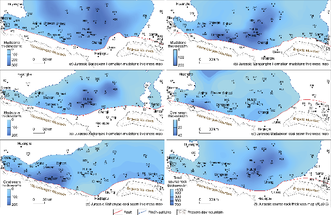
Fig. 8. Planar distribution map of Jurassic and major formation source rocks, total thickness distribution of effective source rocks in the southern margin of Junggar Basin. |
3.1.2. Permian source rocks
Limited by deep-layer data, the distribution of Permian source rocks was not clearly recognized in the past. In this paper, the macro distribution of Permian source rocks was anew tracked and characterized based on 40 pieces of time-frequency electromagnetic data of 2 029 km, 2 pieces of 1:50 000 high-precision gravity and magnetism data of 16 612 km2, combined with new drilling geochemical data (wells TW1, HT1 and GT1), ground outcrops (15 outcrops such as Honggou, Jingjingzigou, etc.) and 147 pieces of 2D seismic data of 4 750 km (Fig. 9). The results show that the Permian source rocks in SMJB are jointly controlled by ancient rifts and highs, forming a distribution pattern of "narrow grooves in the west segment, multiple sags in the middle segment, and wide basins in the east segment". The Sikeshu Sag in the west segment develops NW-SE trending grooves (with a maximum thickness of 400 m), and the middle segment is separated by paleo-highs such as Yilinheibiergen Mountain to form 3 near EW trending grooves (with a maximum thickness of 700 m), while large grooves (with a thickness of 600 m) are developed around Bogeda Mountain in the east segment. Geochemical analysis shows that the average TOC of the Middle Permian in Fukang-Urumqi area is 7.60%, and the maximum is 26.66% [22-23]. It is dominated by lacustrine organic matter and has significant hydrocarbon generation potential. In terms of hydrocarbon generation contribution, the lighter isotopic composition of condensate oil in Well TW1 (Pr/Ph<1, and Pr/nC17<0.5) and the mixed source characteristics of Well HT1, confirming that the Permian source rocks are complementary to the oil and gas reservoirs of middle segment in SMJB. The thermal evolution study shows that the Permian source rocks entered the oil generation stage from the Early Jurassic and entered the gas generation peak in the Early Cretaceous, which is an important potential gas source rock in the middle segment.
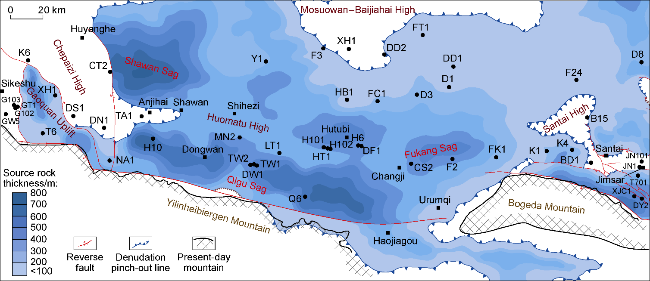
Fig. 9. Map of predicted thickness of Middle-Lower Permian source rocks in the southern margin of Junggar Basin. |
3.2. Hydrocarbon accumulation in typical structural segments and favorable deep exploration targets
Early exploration confirmed that there were obvious differences in hydrocarbon accumulation patterns and enrichment laws among the west, middle and east segments of SMJB [16-23]. This paper focuses on the evaluation of reservoir forming factors such as "source rock and reservoir distribution characteristics, tectonic evolution sequence, trap development types, and later preservation conditions" of typical structural belts in SMJB, and identifies the main controlling factors of reservoir formation in each belt, hoping to provide important reference for oil and gas exploration and the selection of development fields and directions (Table 2). According to the author's research, the exploration strategy and future exploration fields of the ultra-deep lower combination of oil and gas in SMJB are as follows: concentrated exploration in 5 proven areas (Dongwan structural belt, Tudong structural cluster, Hutubi structural belt, Fangcaohu structural belt, Sangjiaquzi structural belt), breakthrough in 3 potential areas (Manas anticline, Tugulu anticline, Anjihai anticline), and risk guidance in 2 preparation areas (footwall of Qigu fault fold belt and near-source slope area of Sikeshu sag).
Table 2. Exploration evaluation in the southern margin of Junggar Basin |
| Structural belt | Target layer | Trapping elements | Reservoir-controlling factors | Confidence level | Exploration level | |||||
|---|---|---|---|---|---|---|---|---|---|---|
| Numble of trap | Trap area/km2 | High burial depth/m | Source conditions | Preservation condition | ||||||
| Dongwan structural belt | K, J | 5 | 658.3 | 7 035-9 200 | P, J, K with in the source | Good | High | Concentrated exploration In five major proven zones | ||
| Tudong structural belt | K, J3, J2 | 5 | 168.0 | 6 800-8 200 | P, J, K with in the source | Good | High | |||
| Hutubi structural belt | K1q, J3, J2 | 4 | 184.3 | 6 620-7 900 | P, J, K with in the source | Good | High | |||
| Fangcaohu structural belt | K1q, J2t, J2x | 13 | 1 465.4 | 4 500-7 800 | P, J source edge | Good | Middle | |||
| Sangjiaquzi structural belt | K1q, J2t, J2x | 6 | 465.0 | 4 500-7 800 | P, J source edge | Good | Middle | |||
| Manas anticline | K, J2, E | 2 | 368.1 | 7 300-8 200 | P, J with in the source | Risk | Low | Get rid of breakthroughs in three major potential areas | ||
| Tugulu anticline | K, J2, E | 2 | 168.1 | 7 300-8 200 | P, J with in the source | Risk | Low | |||
| Anjihai anticline | E, K, N | 3 | 211.8 | 6 200-8 200 | P, J with in the source | Risk | Middle | |||
| Qigu fault fold footwall | K, J3, J2, J1 | 27 | 1 487.0 | 2 500-12 000 | P, J with in the source | Normal | Low | Risk leadership In two major preparation areas | ||
| Sikeshu sag near source slope area | Aika-Du’an structural belt | K1, J2 | 6 | 192.4 | 2 200-5 900 | P, J source edge | Risk | High | ||
| Gaoquan structural belt | K, J2 | 3 | 46.2 | 5 750-6 600 | P, J source edge | Risk | High | |||
3.2.1. Reservoir formation characteristics and favorable exploration zones in the west segment
The gas accumulation conditions in the west segment are good, and 2 sets of Jurassic and Permian source rocks are developed (speculated), and the central area of hydrocarbon generation is 1 300 km2. Well and outcrop data show that 5 sets of large-scale reservoirs such as Ziniquanzi Formation, Qingshuihe Formation, Toutunhe Formation, Sangonghe Formation and Badaowan Formation are developed in this area [24-25], and there is an overlap in Jurassic-Cretaceous. The overall structural heights are consistent, and the remaining structural traps are developed in scale. Oil and gas accumulation is affected by the main factors such as "trap-source distance, ancient and current structures, and later preservation". The ancient and current structures in the uplift area are successively developed, and the phenomenon of early-late fault "hand in hand" and vertical adjustment of oil and gas is prone to occur. The near-source core area is close to the hydrocarbon kitchens. Multiple traps such as structural traps, stratigraphic traps and lithologic traps are well developed and still have good exploration potential, which is an important field for implementing new types of exploration in SMJB. This paper systematically analyzes Gaoquan oil and gas reservoir and basically defines the main reservoir controlling factors and directions. Gaoquan anticline cluster (Fig. 7) shows the characteristics of active near sag and poor display far sag as a whole [26], indicating that near-source accumulation is a major feature of oil and gas accumulation in this area. The Cretaceous Qingshuihe Formation reservoir drilled through by Well GT1 in Gaoquan anticline has the characteristics of early accumulation and late adjustment [27]. The anticline trap in Gaoquan anticline developed in succession from Indosinian to Middle Yanshanian. Jurassic oil and gas in Middle Yanshanian filled Qingshuihe Formation and Toutunhe Formation along Yanshanian faults and formed large-scale reservoirs. The analysis results of Well G102 show that Qingshuihe Formation and Toutunhe Formation had formed large-scale ancient oil and gas reservoirs in the early stage [27]. During the Himalayan period, the structural highs of the Cretaceous Qingshuihe Formation migrated from south to north, some early reservoirs were adjusted to the high position, and some were adjusted to the shallow layer along the detachment faults. The analysis of wells G102 and G103 shows that the Shawan Formation has a high content of adsorbed hydrocarbon and develops oil layers. The resistivity of the fluorescent sandstone in the Gaoquan-Shawan Formation is low, generally lower than that of the surrounding rock, and there may also be low resistivity oil layers, indicating that the reservoirs in this area were adjusted previously. At present, Qingshuihe Formation in the lower combination of Gaoquan anticline presents the characteristics of large structure and small reservoir.
3.2.2. Reservoir formation characteristics and favorable exploration zones in the middle segment
The geological conditions for hydrocarbon accumulation in the middle segment of SMJB are the most favorable. Multiple sets of extremely thick cap rocks are developed with good vertical preservation conditions. 2 sets of extremely thick source rocks, Jurassic and Permian, are developed vertically, with the 4 800 km2 central area of hydrocarbon generation. The middle segment is adjacent to the southern provenance. Outcrops and drillings reveal that there are 7 sets of large-scale high-quality reservoirs in this area, including Ziniquanzi Formation, Donggou Formation, Qingshuihe Formation, Kalaza Formation, Toutunhe Formation, Sangonghe Formation and Badaowan Formation. Affected by the early low uplift background, the trap-source spatial-temporal configuration is good. The middle segment is an important field and zone for searching for large-scale natural gas reserves.
According to the strength of structural deformation, Dongwan, Tudong and Hutubi structural belts are the key exploration targets with weak vertical structural deformation and large transverse deformation space. The Fangcaohu and Sangjiaqu belts are jointly controlled by the Chemo Low Uplift and the Baijiahai High, and existing pinch-out of Early Jurassic denuded strata and pinch-out of Late Cretaceous overlying strata. Therefore, with the stratigraphic-lithologic trap forming background and relatively shallow lower combination, they are lithologic-stratigraphic composite exploration fields. Huomatu and Anjihai structural belts (Fig. 7) have relatively intense structural deformation, and the confidence level and preservation conditions of effective traps are the key factors restricting oil and gas exploration in this area.
This paper focuses on the analysis of the reservoir forming characteristics of the Huomatu structural belt. The Huomatu structural belt has intense overall deformation and relatively complex reservoir formation. Combined with the analysis of the structural formation period mentioned above, the formation period of the lower combination structure matches the late hydrocarbon expulsion period of the Jurassic and Permian source rocks [23]. The main structural area is prone to form the "hand-in-hand" phenomenon of multi-stage fault connection. The effective trap in this belt is the basis of reservoir formation and the key to preservation conditions. The middle combination anticline structure is a favorable place for the conformation of high-efficiency oil and gas reservoirs. At present, the successful drilling of Well MN2 in the north wing of Manas fault anticline has further confirmed that the middle combination has the characteristics of "one block one reservoir", and its anticline belt surrounding area has the potential to discover complex fault block oil and gas reservoirs. The lower combined anticline structure in this area is characterized by multi-stage structural activity and multi-stage faults overlapping vertically, which makes it difficult to accurately describe the trap, and the preservation conditions of its main structure may be at risk. In 2019, the water type of Well LT1 drilled for the lower combination in the Tugulu anticline was NaHCO3, the salinity was 10 019.6 mg/L, and the chloride ion concentration was 3 545 mg/L, showing an open environment, indicating that the gas reservoir may be damaged and adjusted many times. However, there should be undamaged areas in the east and west wings of the anticline where the two stages of faults are weakened, which is speculated to have large-scale exploration potential (Fig. 10). In addition, the buried depth of the lower combination is large, and the velocity of the overlying strata variation changes sharply in vertical and horizontal directions, making the accurate implementation of the structures the key to the exploration breakthrough. Taking Well TA1 as an example, the dual structure style was established based on previous seismic data in the early stage, and it was confirmed that the main exploration target layer K was a large anticline structure, resulting in drilling failure. Through "two-wide and one-high" 3D seismic exploration and drilling, it is revealed that the structure is a three-layer superimposed structure, the high point in trap settled in the early stage migrates 1.4 km to the north, and the altitude of the target layer is 340 m lower than the high point, which is outside the trap overflow point, indicating that the well failed mainly because of inaccurate trap determination. It is suggested to drill the northern long-axis anticline at an appropriate time to open up a new prospect of the lower combination exploration in the area.
Fig. 10. Hydrocarbon accumulation evolutionary model of the Huomatu structural belt. |
3.2.3. Reservoir formation characteristics and favorable exploration zones in the east segment
The geological conditions in the east segment of SMJB are more complex. Although there developing multiple sets of exploration strata such as Kalaza Formation, Qigu Formation, Toutunhe Formation and Sangonghe Formation, with good development potential [15,20], the detachment layer in this area is single, the deformation space is narrow, the structural deformation is intense, and the vertical preservation conditions are poor as a whole. Therefore, the areas with better preservation conditions in the footwall and the stable structural areas in the hanging wall are the key areas for the breakthrough of risk exploration. Taking oil and gas reservoir from Well XJC1 as an example, this paper dissects and defines the main reservoir controlling factors.
Oil and gas reservoir in Well XJC1, located in the hanging wall of Fukang fault zone, with unconventional oil and gas reservoirs in the source and conventional oil and gas reservoirs above the source, with the characteristics of early large-area continuous accumulation and late adjustment accumulation. The hydrocarbon source rocks of Permian Lucaogou Formation in this area began to generate oil on a large scale during the Indosinian-Early Yanshanian, forming a quasi-continuous large- area oil reservoir of Permian Lucaogou Formation [28]. During the large-scale hydrocarbon generation period of Permian source rocks in the Middle and Late Yanshanian, part of the oil flow was injected along the late faults to Permian Wutonggou Formation and Triassic Karamay Formation to form fault block and lithologic reservoirs. During the Himalayan period, the Northern Tianshan Mountains were intensively active, the high-steep areas in the north and south of the hanging wall were strongly uplifted affected by thrust faults, the strata suffered continuous denudation, and the oil and gas reservoirs were adjusted to form local residues of fault block and lithologic reservoirs. The Permian Lucaogou unconventional oil reservoir in the structural stable area is well preserved and is expected to form a quasi-continuous large-scale oil and gas reservoir.
4. Conclusions
The superimposition of 2 stages of pre-existing structures and 3 sets of plastic detachment layers in SMJB controls the vertical stacking style and horizontal deformation space, forming a four-layer composite structural deformation sequence ("4-story building structure"), which has the structural characteristics of "horizontal segmentation of paleo-highs controlling belts, and multiple detachment layers controlling layers vertically". 5 weakly deformed structural clusters, 3 moderately deformed anticline clusters and a row of strong deformation areas are developed in the middle segment as a whole, mainly for large and medium-sized targets. The overall deformation of the west and east segments is intense, and 1-2 rows of structural belts are developed within the segment, and small and medium-sized structural targets are developed within the belts.
Two sets of main whole oil and gas systems are developed in SMJB, which constitute a 4-story compound oil and gas accumulation structure mode ("multi-story building" accumulation structure). Jurassic hydrocarbon sources are widely distributed in SMJB. 5 local hydrocarbon kitchens are developed in Permian, which mainly experienced 3 times of hydrocarbon expulsion in Early Jurassic, Middle Jurassic and Early Cretaceous. The middle-lower combinations in SMJB have the characteristics of "multi-stage, multi-layer and zoning", and hydrocarbon accumulation is mainly controlled by "effective traps, preservation conditions and trap-source matching relationship".
Through the overall research and evaluation of SMJB, the conventional-unconventional oil and gas are taken into account together, the exploration potential of deep coal rock gas is highly valued, and the zones and targets are comprehensively evaluated according to the strength of structural deformation, the degree of trap confirmation, the trap-source matching relationship, the advantages and disadvantages of preservation conditions and the burial depth of the target layer. The hierarchical exploration strategy of the deep to ultra-deep lower combination in SMJB is further proposed, and the future 10 strategic areas for oil and gas exploration are pointed out: concentrated exploration in five proven areas (Dongwan structural belt, Tudong anticline cluster, Hutubi anticline belt, Fangcaohu structural belt, Sangjiaquzi structural belt), breakthrough in three potential areas (Manas anticline, Tugulu anticline, Anjihai anticline), and risk guidance in two preparation areas (footwall of Qigu fault fold belt and near-source slope area of Sikeshu sag).