

Introduction
Recent exploration of energy and mineral resources in the Ordos Basin has exhibited several new trends. First, important breakthroughs have been made to unconventional oil and gas exploration [1-2]. Shale oil resources in the 7th Member of the Middle-Upper Triassic Yanchang Formation amount to 109×108 t, and the proven reserves exceed 20×108 t. Major breakthroughs have been also made to coal-rock gas, tight sand gas, shale gas and tight limestone gas within the Carboniferous-Permian coal-bearing series [3-5], with the natural gas resource scale exceeding 20×1012 m3. In the bauxitic rock layer of the weathering crust at the top of the Ordovician, Well Long 47 obtained a high-yield gas flow of 67.4×10⁴ m3/d during well test, and the natural gas resource scale reached 1×10¹² m3 [6]. Second, beneath the salt layer in the 6th sub-Member of the 5th Member of the Ordovician Majiagou Formation in the central-eastern part of the basin, Well Mitan1 obtained a high-yield industrial gas flow of 35.24×10⁴ m3/d during well test from the 4th Member of the Majiagou Formation [7-8], with the natural gas resources amounting to 1×10¹² m3. The whole basin is rich in oil and gas resources which are three-dimensionally distributed, orderly coexistent, conventional and unconventional within multiple strata (Mesozoic, Upper Paleozoic and Lower Paleozoic) and of diverse types.
By now, oil and gas exploration has extended beyond the present-day “basin boundary”. On the western side, shale gas has been discovered in the Ordovician Wulalike Formation (O3w) with reserves reaching 1×10¹² m3 [9-10]. Tight sand gas has been found in the Carboniferous Yanghugou Formation (C2y) within the Shigouyi Syncline and the Weizhou Syncline. Oil exploration is approaching the Huianbu-Shajingzi Fault Zone, and tends to enter the interior of the western margin fold-thrust zone. Several areas with 100-million-ton scale reserves have been discovered, such as Hongde-Shancheng, Pingliang North and Yanchi West. In the entire SN trending Jinxi Flexural Fold Belt on the eastern side, Carboniferous-Permian coal-rock gas reserves have been confirmed 1×10¹² m3, and shale gas resources of marine-continental transition facies in the 2nd Member of the Shanxi Formation (P1s2) exceeded 1×10¹² m3 [11-12]. On the north side, exploration has crossed the Yimeng Uplift into the Hetao Graben. The proven oil reserves in the Cretaceous and Oligocene exceeded 2×10⁸ t in the Linhe Depression, and an oil field with annual output of 200×104 t has been built rapidly [13]. On the south side, commercially viable helium gas has been found in multiple exploration wells in the Weihe Graben [14], and abundant geothermal resources have been discovered in multiple shallow wells and water wells. At present, exploration for conventional and unconventional oil and gas, helium gas and geothermal resources has surpassed the “traditional” boundaries of the Ordos Basin. Considering that the Hetao Basin, the Weihe Graben and surrounding mountains were more or less connected to the Ordos Basin during the geological history, it is necessary to conduct an in-depth evaluation on exploration scope, basin boundaries and hydrocarbon-bearing geological units in the Ordos Basin.
The scope or boundary of oil and gas exploration is constrained by the distribution of sedimentary basins. The Ordos Basin is a composite superimposed basin formed by lateral amalgamation and vertical stacking of sedimentary basins in different geological historical periods [2-3,15]. The present-day basin boundary gradually took shape during the Triassic Indosinian Orogeny [16-17]. Throughout the geological history, the basin boundary, sedimentation and filling, nature and tectonic units were dynamic, namely its shape, nature and material composition varied across different periods. Accurately delineating the basin boundaries in different geological epochs is not only fundamental to reconstructing the prototype basin but also essential for expanding hydrocarbon exploration frontiers.
There are two major difficulties in studying the boundaries of sedimentary basins in geological history. First, early boundaries became blurred after late reformation and reconstruction. For example, the western boundary of the Ordos Basin in the Middle and Late Triassic [16-17] is difficult to restore because a series of north-south faults in the western margin thrust belt have undergone multiple thrusting or transpressional deformation since the Indosinian period, cutting and transforming the large lake basin during the sedimentary period of the Yanchang Formation in the Late Triassic. However, dark mudstone in the 7th Member of the Yanchang Formation was successively discovered during the drillings on the western margin of the basin, indicating that the basin boundary was not controlled by late north-south faults and it could extend westward to Jingtai and Lanzhou areas. This phenomenon also exists on the eastern, southern and northern boundaries. Second, as for Paleozoic marine basins [18], they are different from Mesozoic and Cenozoic continental basins [1,16 -17]. The latter have obvious basin boundaries and developed basin margin facies, while the former have no "explicit" "basin" boundaries. Because Paleozoic "basins" are "filled bodies" composed of sedimentary sequences. Their sedimentary ranges are controlled by plate boundaries and ancient land distribution of the same period, and much wider than Mesozoic and Cenozoic "basins". It is not easy to accurately determine the "range" of Paleozoic marine sediments. For the above reasons, petroleum geologists or oil and gas explorers are more likely to accept and use the concept of "basin" in the traditional sense. Constrained by the concept of exploration rights, they often "ignore" the structural-sedimentary environment and sedimentary and filled composition in the original basin beyond the current "basin" boundary. The consequence of this "ignoring" or adherence to mining rights is that the "evaluation unit" or "exploration idea" is limited to the present basin units or available exploration blocks, so that it is difficult to expand effectively, or losing actual high-quality exploration blocks when selecting "mineral rights". Similar cases are common in global oil and gas exploration practices.
This study addresses the issue of basin boundaries in the Ordos Basin across different geological periods. By integrating drilling data and regional seismic interpretation in the basin, in combination with the new progress and understanding made in geological surveys around the basin in recent years, applying the concept and methodology of mobile tectonic theory and paleogeography, the tectonic process of the peripheral plates is combined with the evolution of the basin. From the perspectives of spatio-temporal distribution, the "prototype basin" range of the Ordos block and its adjacent areas in different geological history periods is revealed as a whole, and its evolution sequence is restored. This aims to sup-port the evaluation of exploration frontiers (new strata, new types, new areas) and mineral resource assessments in the Ordos Basin.
1. Geologic setting
Geographically, the Ordos Basin stretches from the northern Qinling Mountains in the south to the Yinshan Mountains in the north, from the Helan-Liupan Mountains in the west to the Lüliang Mountains and Zhongtiao Mountains in the east. It spans five provinces/regions, namely Shaanxi, Shanxi, Inner Mongolia, Gansu and Ningxia. It is approximately rectangular in plan and covers an area of about 0.37×10⁶ km2, making it the second largest sedimentary basin in China [18-19]. The tectonic units can be divided from west to east into the Western Margin Thrust Belt, the Tianhuan Depression, the Yi-Shaan Slope and the Jinxi Flexural Fold Belt [18]. The Weibei Uplift and the Yimeng Uplift are in the south and north respectively. The average thickness of the sedimentary strata is 6 000 m. Three sets of gas-bearing strata are developed, namely the Upper Paleozoic, the Lower Paleozoic, and the Middle Proterozoic. And two sets of oil-bearing strata have been found, namely the Mesozoic Triassic and Jurassic of the Mesozoic.
In terms of tectonic location, the Ordos Block is located in the western part of the North China Craton, between the Alxa Block and the eastern North China Block (the Bohai Bay-Korea Block) [19]. The Helanshan-Liupanshan Mountain Tectonic Belt separates it from the Alxa Block in the west. The Lüliangshan-Taihangshan Fold Belt separates it from the eastern North China Block in the east. The Hetao Graben connects it to the Yinshan Fold Belt in the north. And the Weihe Graben connects it to the Qinling Fold Belt in the south (Fig. 1).
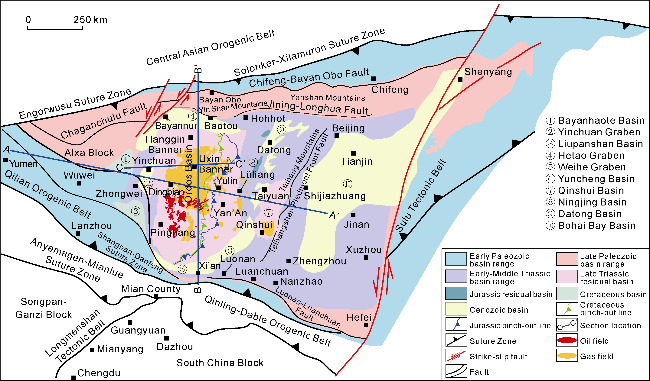
Fig. 1. Outline of block tectonics of the North China Craton, the geotectonic position of the Ordos Basin and the distribution of oil and gas fields. |
The basement of the Ordos Basin is the crystalline basement of the Archean and Paleoproterozoic [19-21], on which the sedimentary cover of the Mesoproterozoic Changcheng System to the Quaternary System is developed [18-19,22], with a regional unconformity between the two. The sedimentary cover consists of the Mesoproterozoic Changcheng System and Jixian System, the Neoproterozoic Sinian System, the Lower Paleozoic Cambrian and Ordovician, the Upper Paleozoic Carboniferous and Permian, the Mesozoic, and the Cenozoic [18-19]. Among them, seven regional unconformities are developed: the base of the Cambrian, the base of the Majiagou Formation of the Middle and Lower Ordovician (Huaiyuan Movement surface), the top of the Ordovician (Caledonian Movement surface), the top of the Triassic (Indosinian Movement surface), the top of the Jurassic (Early Yanshan Movement surface), the top of the Cretaceous (Late Yanshan Movement surface), and the top of the Paleogene (Himalayan Movement surface) [18,23]. The Ordos Basin is divided into four sets of tectonic-stratigraphic sequences: the Mesoproterozoic and Neoproterozoic, the Cambrian- Ordovician, the Upper Carboniferous-Triassic, and the Jurassic-Cenozoic. Correspondingly, the Basin experienced four extension-convergence cycles [15,18,23 -24].
2. Basement composition and boundaries of the Ordos Block
2.1. Geophysical fields and basement properties
The main part of the Ordos Block was formed by the Alxa-Yinshan Block and the Ordos Block (narrowly defined) to its south along the Khondalite Belt at 1.95 Ga, forming the Western Block. The Yanliao-Longgang Block and the Langlin Block were combined along the Jiao- Liao-Ji Orogenic Belt at 1.90 Ga to form the Eastern Block. The Eastern and Western Blocks were combined along the Central Belt (Lüliang-Taihang Mountain Area) at 1.85 Ga to form the North China Craton Basement [19-21,24 -25]. The rock assemblage and detrital zircon age spectrum of the Mesoproterozoic-Neoproterozoic sedimentary rock series in the Alxa Block generally have the characteristics of provenance from the North China Craton, reflecting that the Alxa Block was still part of the North China Craton until the Mesoproterozoic-Neoproterozoic [26].
Based on the Chinese crust model obtained by joint inversion of seismic S-wave velocity (Vs) tomography and gravity anomalies [27], the lithospheric structure profile of the Ordos Block and its adjacent areas was intercepted (Fig. 2). On the S-wave velocity (Vs) profile of the Alxa-Ordos-Taihang Mountain block (Fig. 2a), the Vs changes are consistent, revealing that the Alxa block and the Ordos Block have almost consistent changes in burial depth of the Moho surface and lithospheric mantle structure. The changes in Vs plane distribution map at burial depths of 10, 40, and 110 km are also relatively continuous, which shows broad consistency with previous seismic tomographic inversion [28-29]. On the north-south Vs profile of the Qinling Fold Belt-Ordos Block-Yinshan Fold Belt (Fig. 2b), the Vs value changes continuously. There is no strong change in the Vs value below the Weihe Graben and the Hetao Graben, which is consistent with the fact that the Moho surfaces of the Weihe Graben and the Hetao Graben, given by broadband seismic reflection and deep reflection seismic profiles, only rise by 2-3 km and 3-4 km, respectively [29]. At 40 km burial depth, the Tsaidam Block-northeastern Tibetan Plateau changes greatly. A sharp change occurs along the coastal fault zone to the Ordos Block. At 110 km burial depth, the eastern part of the North China Block changes greatly. And a sharp gradient zone appears on the east and west sides of the Datong-Jinzhong-Luoyang line to the Ordos Block. According to available seismic refraction, deep reflection and magnetotelluric (MT) sounding profiles [30-31], the crustal composition of the Ordos Block and its adjacent units is basically consistent (Fig. 2). The scope of the "Ordos Block" revealed by geophysical data is a large area bounded by the Engorwusu Fault in the west, the Taihangshan Mountain Piedmont Fault in the east, the Haiyuan Fault in the southwest, the Shangnan-Danfeng Suture Zone in the south, and the Solonker-Xilamuron Suture Zone in the north (Fig. 1). The geographical boundaries are basically consistent with the tectonic boundaries discussed below.
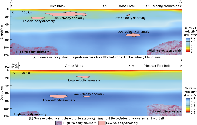
Fig. 2. S-wave velocity (Vs) structure profile of the lithosphere across the Ordos Block and surrounding orogenic belts (see Fig. 1 for the profile location). |
The basement of the Ordos Block is composed of a southern block and a northern one. The dominant aeromagnetic anomalies are NE-trending, and the positive and negative anomalies are alternative [18-19,21,27,30 -31]. The basement in the northern block is composed of metamorphic crustal rocks such as mixed lithified meta-pelitic rocks, variegated gneiss, schist, marble and quartzite, and some granite gneiss [19-21]. It records two phases of magmatic activity at the end of the Neoarchean about 2.50 Ga and at the middle of the Paleoproterozoic (2.0-2.2 Ga), as well as metamorphism at the end of the Paleoproterozoic (1.85-1.95 Ga) [19-21]. The major basement is a landmass composed of Neoarchean continental crust materials. A continental margin activity belt developed on the Neoarchean continental crust basement in the late Paleoproterozoic. The basement in the southern block is mostly granite gneiss, except for a small amount of parametamorphic rocks. It records the magmatic thermal event in the middle Paleoproterozoic of 2.0-2.2 Ga and the metamorphic event at 1.85-1.95 Ga [19-21]. In addition to the Neoarchean materials, there are Paleoarchean and Mesoarchean continental crust materials [20-21]. It is an ancient block composed of a certain scale of Mesoarchean and part of Paleoarchean continental crust materials and Neoarchean new continental crust [21]. They constitute the main ancient continental crust basement of the Ordos Block [19,21,25]. There is an aeromagnetic anomaly gradient zone along the Datong-Huachi basement fault zone [20-23]. Along the southern edge of this zone, a Paleoproterozoic arc magmatic activity zone at 2.0-2.2 Ga was developed, and it underwent metamorphic transformation at 1.85- 1.96 Ga. It may be a tectonic activity zone formed in the middle and late Paleoproterozoic in the block. The strong aeromagnetic anomaly zone between the Huanxian-Yulin Fault and the Datong-Huachi Fault separates the basement of the Ordos Basin into two areas, a southern one and a northern zone, represented respectively by the Hutuo Group and the Jining Group [23]. Between the two groups may be their joint developed in the late Paleoproterozoic [21,23]. The structure had a strong control on the basin evolution in the Mesoproterozoic and Neoproterozoic and later.
2.2. Boundary of the Ordos Block
Before the Triassic, the main part of the Ordos Block was in the range of ocean-continent or sea-continent. Under that tectonic background, from land to ocean, the lithofacies of restricted platform, open platform, platform margin, slope, semi-deep sea and deep sea would develop, and a series of basin types would appear, including intra-cratonic sag, passive continental margin (from proximal zone to distal zone), continent-ocean transition zone (COT) and even ocean basin. Therefore, for the "original basin" of the Paleozoic, its boundary often extends to the boundary of the block. The northern boundary of the Ordos Block is the Solonker-Xilamuron Suture Zone, the southern boundary is the Shangnan-Danfeng Suture Zone, the western boundary is the Engorwusu Suture Zone, and the eastern boundary is the Taihangshan Mountain Piedmont Fault Zone. The tectonic properties of these boundaries are inconsistent in different periods.
2.2.1. Northern boundary
The northern boundary of the present-day Ordos Basin is the Yellow River Fault, a boundary fault between the Yimeng Uplift and the Hetao Graben. However, in the Paleozoic, the northern boundary of the North China Plate where the Ordos Block is located was the Solonker-Xilamuron Suture Zone [32-33] (Fig. 1), which was the final suture after the closure of the Paleo-Asian Ocean. There is another view that the northern boundary of the ancient North China Craton is the Wude-Bainaimiao- Huade North Fault [34], between which and the Solonker- Xilamuron Suture Zone is the Baoerhantu-Zhurihe Early Paleozoic continental margin accretionary orogenic belt [34]. However, from the evolution perspective of the North China Plate, the northern boundary is the Solonker-Xilamuron Suture Zone.
The Paleo-Asian Ocean was originated from 1 350 Ma [35], opened between 850 Ma and 970 Ma, experienced initial subduction between 700 Ma and 850 Ma, and reached peak ocean basin expansion between 550 Ma and 620 Ma[33-34,36]. Between 250 Ma and 600 Ma, the Paleo-Asian Ocean underwent multiple accretionary processes of different source terranes, and eventually developed into the Central Asian Orogenic Belt [34-39]. The zircon SHRIMP ages of the Ondurmiao ophiolite and intra-oceanic arc range from 429 Ma to 497 Ma [37-38].
The Paleo-Asian Ocean on the north side of the Ordos Block experienced a scissor-shaped diachronous closure from west to east [39-40]. It is speculated that it closed at the end of the Middle Permian [33,39 -40]. The two branches of the Paleo-Asian Ocean in the east (the Hegenshan Ocean Basin and the Solonker Ocean Basin) were still limited ocean basins in the Late Permian (about 256 Ma). They were almost simultaneously closed at the beginning of the Early Triassic (about 250 Ma) [41]. The Paleo-Asian Ocean was completely closed. The fundamental tectonic framework of the Central Asian Orogenic Belt was established [32,39,41].
The Paleo-Asian Ocean underwent bidirectional subduction, and the southward subduction formed a magmatic island arc belt on the northern margin of the North China Block [34]. The magmatic activity on the northern margin of the North China Block is represented by the Bainaimiao continental margin arc (420-520 Ma) and the Late Silurian-Early Devonian basic, ultrabasic, intermediate-acidic, and alkaline rocks on the northern margin of the North China Craton (380-417 Ma) [42-43]. There was an obvious hiatus in magmatic activities about 360-380 Ma, and the magmatic activities after that continued from the Carboniferous to the Early Triassic. In the Permian, there was an orogenic belt similar to the Andes Plateau in western South America in the northern margin of the North China Block, with an estimated paleo-altitude of (3.8±0.7) km [44]. A back-arc foreland basin developed on the side adjacent to the Ordos Block. The Permian System herein displays a vertical succession of coal-bearing and thick conglomerate units (humid climate indicators) at the bottom, and continental red beds (arid climate signature) at the top. Detrital zircon provenance analysis reveals that the sediments were derived from the Early Precambrian basement and overlying Late Paleozoic continental magmatic arc (260-410 Ma), but no detectable input from the Solonker Suture Zone and Paleozoic juvenile arc materials to its north [44]. The island arc-shaped orogenic plateau developed on the northern margin of the North China Block during the Permian blocked water vapor from northeast, namely the Paleo-Asian Ocean. It’s an important tectonic driving mechanism for the Permian aridification of North China such as the red beds of the Shiqianfeng Formation.
2.2.2. Southern boundary
The southern boundary of the present-day Ordos Basin is traditionally considered to be the boundary between it and the Weibei Uplift. In fact, this is the transitional position between the uplift wing on the north side of the Weihe Graben in the Cenozoic and the “main part” of the Ordos Basin. In the Early Paleozoic, the southern boundary of the Ordos Block was on the northern boundary of the Shangnan-Danfeng Ocean Basin (the Shangnan-Danfeng Ophiolite Belt as its residual part) [45-46].
The Qinling Orogenic Belt consists of the North Qinling Block and the South Qinling Block. The suture zone between the North Qinling Block and the North China Craton is along the Xi'an (Shaanxi Province)-Luonan-Luanchuan-Nanzhao line [45-47]. Based on the geochronological data of the ophiolite suite and subduction-derived gabbros in the Qinling Mountains [46], it is believed that during the Middle-Late Ordovician, the Erlangping back-arc ocean basin between the North Qinling Block and the North China Block subducted and closed [46-47], resulting in a back-arc foreland basin on the southern margin of the Ordos Block. The amalgamation of the North Qinling Block and the South Qinling Block occurred in the Early Devonian [46-47], mainly along the Shangnan-Danfeng line. The collision and amalgamation of the Yangtze Block and the South Qinling Block mainly occurred in the Middle Triassic-Early Jurassic [45]. This collision led to the final formation of the Qinling-Dabie Mountains Orogenic Belt [48]. The above results indicate that the northern part of the Qinling Mountains has been an uplift area since the Early Paleozoic, constituting the provenance area of the southern Ordos Basin [17,19].
2.2.3. Western boundary
The Engorwusu Suture Zone is the western or northwest boundary of the Ordos Block (Fig. 1), and its main part is an ophiolite mélange belt [32,49]. This fault zone is located on the northern edge of the Alxa Block and the southern part of the middle section of the Central Asian Orogenic Belt, between the Yagan Tectonic Belt and the Zhusileng-Hangwula Tectonic Belt in the Alxa area. It is the boundary fault between the Tarim Block and the North China Craton Block, representing the closing location of the Paleo-Asian Ocean [32].
The Engorwusu Ophiolite Belt is located on the northern edge of the North China Block. It began to rift in the Cambrian on the basis of the Proterozoic basement and gradually formed an Early Paleozoic ocean basin. The ocean basin underwent bidirectional subduction in the Late Ordovician-Silurian, and the Engorwusu Ophiolite Mélange Belt was formed in the Late Devonian-Early Permian [49]. The North China Block and the Tarim Block finally merged at the end of the Late Permian [32,39 -41,50].
The ancient Asian Ocean basin in the Engorwusu area subducted southward, creating the Zongnaishan-Shalazhashan continental crust basement volcanic arc and the Late Paleozoic Chaganchulu back-arc ocean basin to its south at the end of the Silurian. In the late stage of Late Paleozoic, the Chaganchulu back-arc basin subducted, leaving a continental margin arc at the northern edge of the Alxa block, and the Carboniferous-Permian continental margin arc volcanic rock system developed at the same time.
2.2.4. Eastern boundary
The eastern boundary of the Ordos Block is the Taihangshan Mountain Piedmont Fault, i.e., the boundary fault between the Taihang Mountains and the Bohai Bay Basin in the north-south gravity gradient zone [28-32]. This is a dramatic change boundary in crustal thickness and lithosphere thickness, affected by the subduction front of the Mesozoic Izanagi Plate and the Cenozoic Pacific Plate.
Wen et al. [53] used a cluster isotopic compositions analysis to reconstruct the paleoelevation of the northern Taihang Mountains. It was 2.0-2.8 km in the Late Jurassic at 160 Ma, 2.7-3.5 km in the Early Cretaceous at 113 Ma, and 0.7-1.5 km at the end of the Early Cretaceous at about 105 Ma. That is, the initial uplift of the northern Taihang Mountains began in the late Middle Jurassic, continued to uplift in the Late Jurassic, and reached an altitude of more than 3 km at the beginning of the Early Cretaceous. The highlands on the east of the Taihang Mountains collapsed in the Early Cretaceous. Consequently, the eastern margin of the Taihang Mountains Uplift (the Taihang Mountains Piedmont Fault Zone), which defines the eastern boundary of the Ordos Basin, underwent uplift during the Late Jurassic to Early Cretaceous (J3-K1). This established the most prominent tectonic-geomorphic-climatic-ecological division between the eastern and western blocks of the North China Craton, and finally shaped its structure since the Paleogene [15,19,53].
3. Basin extent and tectonic attributes in different geological periods
The Ordos Basin is a sedimentary basin developed on the basis of the Ordos Block. The current narrow sense of "basin" began to take shape since the Late Triassic and was shaped after multiple stages of transformation from the Mesozoic to the Cenozoic [16-17,19]. The "Ordos Basin" in different geological historical periods should be a marine sedimentary basin from the Mesoproterozoic to the Early Paleozoic, a marine-continental transitional sedimentary basin constrained by the plate margin tectonic activity zone from the Carboniferous to the Permian, and a "residual basin" undergoing multiple stages of transformation since the Indosinian.
3.1. A marine basin from the Mesoproterozoic to the Early Paleozoic
The Ordos Basin is a multi-cycle superimposed basin developed on the Archean-Paleoproterozoic crystalline basement through Mesoproterozoic-Cenozoic sedimentary evolution [15,18 -19,54]. The main body of the basin exhibits cratonic characteristics. The basement rocks extensively exposed on the margin of the basin are Neoarchean-Paleoproterozoic metamorphic rock series [19-21,54]. The Paleoproterozoic metamorphic rock assemblages with the characteristics of the Khondalite series, such as the Wulashan Group and the Helanshan Group, can be regarded as the earliest intra-cratonic sedimentary rock series [16,18 -19]. At 5 123 m, Well Pantan1 entered the Paleoproterozoic Xiong'er Group (a formation of the same period as the Hutuo System) from the Beidajian Formation of the Mesoproterozoic Changcheng System. At the bottom of the well at 5 818 m, the lithology is grayish white marble, brown-purple gravelly metamorphosed coarse sandstone, phyllite, gravelly sericite quartzite, etc. Some scholars also classify the Xiong'er Group into the bottom of the Changcheng System [55].
Drilling data show that the Paleoproterozoic Xiong'er Group (or the Hutuo System) rift sediments may represent the first set of sedimentary cover in the basin.
Full-basin sedimentation began from the Changcheng System of the Mesoproterozoic, followed by the Jixian System and the Sinian System. The Mesoproterozoic and Neoproterozoic experienced four evolutionary stages: Changcheng intra-cratonic rift, Jixian cratonic marginal depression, Qingbaikou-Nanhua uplift and Sinian marginal depression [12,16,19 -20,54]. The Mesoproterozoic Changcheng System is widespread rift deposits (Fig. 3) covering the whole North China Craton Block, and forming a wide rift system [15-16,19]. The marginal intra-cratonic depression basin is as large as 1.6×10⁶ km2, where the Jixian sediments are confined to the western and southwestern margins of the basin.
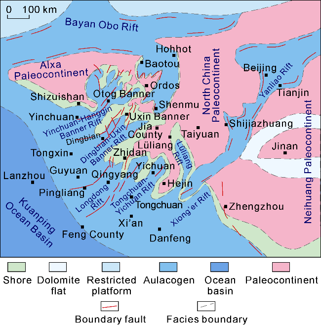
Fig. 3. Schematic diagram of the late Changcheng System structural-sedimentary environment and prototype basin in the North China Craton (a cratonic epimarine basin of 160× 104 km2 and wide rift system caused by regional extension). |
During the Sinian period, the Ordos Block underwent a large-scale tectonic uplift, only a local depression leaving on its southwestern margin. This may represent the reactivation of the basement structure at the margin and indicate the beginning of rifting on the western and southern margins of the Ordos Block in the Early Paleozoic [15,54].
In the Early Paleozoic, the North China Craton was in an extensional stage when rift-shaped passive continental margin basins were developed on both the southern and northern sides [15,18]. An intra-cratonic depression appeared within the plate, and a stable sedimentary structure dominated by carbonate rocks and interlayered with multi-layered gypsum salt rocks was developed in an epicontinental sea environment [15]. In the Middle and Late Ordovician, due to the subduction of the Erlangping Ocean Basin in the south and the Paleo-Asian Ocean in the north, the North China Plate was in a north-south non-coaxial compression environment. The structural- sedimentary differentiation accelerated. The Helan Mountains and the northern Qinling Mountains were rapidly flexed and subsided, and Wulalike Formation (O3w) black shale was deposited on the western edge. By the end of the Ordovician, the North China Plate was uplifted as a whole and suffered weathering and erosion for 120-140 million years, resulting in an unconformity and weathered crust between the Ordovician Majiagou Formation and the Upper Carboniferous Benxi Formation[3].
3.2. A marine-continental transitional sedimentary basin under the constraint of plate tectonics in the Late Paleozoic
In the Late Paleozoic, the Paleo-Asian Ocean subduction system was formed in the north [32,34], and the back-arc foreland basin was formed on the northern margin of the Ordos Block in the late Permian [32-34]. The Eastern Paleo-Tethys Ocean Basin was formed in the A'nyemagen-Mianlüe Subduction Zone on the southern margin [48]. It reached its maximum scale in the Carboniferous and began to subduct northward in the late Permian. Therefore, in the Late Paleozoic, the Ordos Block was an intra-plate depression confined by active southern and northern continental margins.
From the Carboniferous to the Permian, the North China Craton developed into a tidal flat-delta sedimentary system in the context of the continental sea. The ancient terrain was wide and gentle, the climate was warm and humid, and the plants grew luxuriantly. A unique coal-accumulating environment appeared during this geological period [56-57]. Coal-bearing rock systems were widely developed in the North China Block. Since the Late Carboniferous, a vast coal-accumulating depression has been formed [3-4,56 -57]. Its northern boundaries are Yinshan Mountains, Yanshan Mountains and eastern section of the Changbai Mountains. Its southern boundaries are Qinling Mountains, Funiushan Mountains, Dabie Mountains and Zhangbaling Mountains. Its western boundaries are Altyn Fault Zone, with eastern boundaries of the Bohai Sea and the Yellow Sea. It’s a vast intra-cratonic depression [3,57].
The area of the Ordos Basin during this period reached 120×104 km2 (Fig. 4). It is directly connected to the Alxa region in the west. Carboniferous sedimentation in the Qilian Sea area on the west of the Huianbu-Shajingzi Fault was earlier than that on the east of the Dingbian- Qingyang Uplift, i.e., the Central Paleouplift [57]. It is mainly coastal swamp (lagoon)-shore shallow sea sedimentation, with coal series of 200-1 200 m thick. The Yanghugou Formation (C2y) is 500-600 m thick, and the coal seams are mainly developed in the upper section, with continuous distribution and large scale. In the late Paleozoic, the "main part" of the basin developed into an inherited lake basin. The Benxi Formation and the Taiyuan Formation deposited as wide epicontinental sand and mud flat and gray mud flat. The northern part was a marine-continental transitional delta. From the Shanxi Formation to Lower Shihezi Formation, fluvial-deltaic sediments accumulated under the control of southern and northern sources, and the central part of the basin was occupied by lake sediments. To the east, Carboniferous-Permian sediments are relatively thick in the Qinshui Basin and Ningwu Basin, which are connected to the Bohai Bay Basin of 1 500 m to 2 000 m thick.
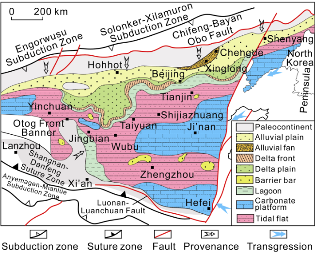
Fig. 4. Lithofacies paleogeographic map of the North China Craton during the depositional period of bottom coal formation at the bottom of the Permian Taiyuan Formation (corresponding to the Bashkirian-Gesherian) (modified from Reference [57]). |
During the Carboniferous-Permian period, a coal-bearing depression basin was developed in the craton of the North China Block. Continental sedimentary systems were mostly distributed in the north, while marine-continental transitional sedimentary systems were mainly distributed in the central and southern parts. Carbonate platform deposits mainly occupied the Benxi Formation and Taiyuan Formation in the central and southern parts[3,5,57].
Ancient uplifts have a segmenting effect on sedimentation. In the early Late Carboniferous, the Wulangar Uplift was an ancient land that divided the North China Coal Basin into two small basins: an eastern basin and a western one. Seawater invaded from east and west. In the late stage of the Late Carboniferous, the Wulangar ancient land sank, and seawater on both sides connected to form a unified coal accumulation depression basin under the background of epicontinental sea [3,57]. The Qingyang Uplift exhibits strong compartmentalization in the early Late Carboniferous. Bays and lagoons were developed on the west side, while the main part was located in the Yinchuan-Otog Front Banner area. Tidal flats and lagoon environments appeared in the Jingbian and Wubu areas to the east, and epicontinental tidal flat environments in Taiyuan and Shijiazhuang. In the late stage of the Late Carboniferous, Qingyang Uplift sank, and seawater on the east and west sides of its northern part connected to form a unified depression basin in the North China Craton [3,5,57] (Fig. 4). The bottom coal formation at the bottom of the Taiyuan Formation, corresponding to the Bashkirian-Gzhelian period, was fluvial and delta deposits in the northern part of North China; alluvial fan deposits in the Chengde-Xinglong area; barrier sand bar-lagoon-tidal flat deposits toward south; and carbonate platform deposits in the west of Ningxia, Liaodong Peninsula, central and eastern North China, eastern Henan and southern Anhui [5]. With 38°N as a boundary, thick coal seams were mainly formed in delta plains, followed by lagoon-tidal flats on the north, and relatively thin coal seams in lagoon-tidal flats on the south [57].
3.3. A continental sedimentary basin from the Mesozoic to the Cenozoic
The Mesozoic Ordos Basin superimposed on the Carboniferous-Permian intra-cratonic depression basin [15-17,19,58]. However, sedimentary interruption between the top and the bottom basins was relatively short, no strong tectonic deformation or major geological events occurred. Except for locally strong activities on the basin margins, such as the Ruqigou area on the western margin, the contact between two basins was almost conformable-parallelly unconformable. The degree of superposition was high [24,58]. The Mesozoic Ordos Basin can be attributed into a continuous intra-cratonic depression basin.
3.3.1. The Super-/Pan-Ordos large lacustrine basin during the deposition of the Yanchang Formation in the Middle and Late Triassic
In the Mesozoic, the sedimentary range of the Ordos Basin far exceeded the present basin. Its sedimentary boundary crossed Shanxi, Henan, Hebei, and Anhui in the east, and crossed the northern edge of the present Qinling Mountains in the south. Its northern and western boundaries exceeded the residual boundary of the present Mesozoic, forming the Triassic Ordos Large Lake Basin (Fig. 5). The basin area in the Early and Middle Triassic was nearly 100×104 km2 (Fig. 5).
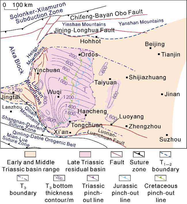
Fig. 5. Distribution of the Ordos prototype basin and adjacent region during the depositional period of the Yanchang Formation in the Middle-Late Triassic. |
From the Permian to the Middle Triassic, the A'nyemagen-Mianlüe Ocean Basin gradually closed in a scissor-like manner from east to west [45-48]. This strong orogenic process not only caused large-scale uplift of the southern margin of the North China Plate and provided material sources, but also led to flexural settlement and deformation in the southern part of the Ordos Block, forming a foreland filling area. In the Middle and Late Triassic, the southern and northern sides of the Ordos Basin were controlled by the Qinling-Dabie Mountain Orogenic Belt and the Central Asian Orogenic Belt, respectively [58-59]. A broad lake basin was formed with steep terrains in the south and gentle terrains in the north, and then filled with river delta and lake basin sediments [9,16 -17]. Intrabasinal sedimentation recorded the compressional activities in these two orogenic belts. The southwestern margin of the Chang 10 Member accumulated thick deposits [60]. Chang 9 and Chang 7 Members received semi-deep lake to deep lake deposits [4-5]. The lake basin was expensive, especially during the Chang 7 deposition, with the maximum area of 50.4×10⁴ km2 (Fig. 5), and became a large depression-shaped lacustrine basin [4-5,22 -23]. The subsequent delta-lacustrine sandstone and mudstone deposits from Chang 1 to Chang 6 Members are relatively thick. Generally, sediments gradually moved from southwest, south, north, northwest or northeast to the center of the basin [59]. The Indosinian Movement at the end of the Late Triassic caused the whole basin to uplift [15-19], resulting in a lacuna from 10 Ma to 40 Ma. Most areas in the basin suffered variable erosion, and Chang 1 to Chang 3 Members missed at the edge of the basin. Large ancient river channels such as Inner Mongolia-Shaanxi, Ningxia-Shaanxi and Gansu-Shaanxi were created in the center of the basin.
3.3.2. A “residual basin” after Triassic superposition and reconstruction
With the breakup of the Pangaea, the Pangong Tso- Nujiang Ocean, the Okhotsk Ocean and the Paleo-Pacific Ocean around the Chinese mainland began to subduct beneath the Chinese mainland since the Middle Jurassic, and then gradually collaged and collided, forming three typical continental margin tectonic belts around the Chinese mainland [60-61]. These orogenic belts on the continental margins gradually spread tectonic stresses into the interior of the continent, resulting in strong intra-continental orogeny and a multi-plate convergence system unique to the East Asian continent in the late Mesozoic [24,60 -61]. This is the direct cause for the disintegration of the Ordos Basin.
In the Early Jurassic, the tectonic deformation was intense. Sedimentation was interrupted, and the northern part of the basin was uplifted and eroded. During the sedimentation period of the Fuxian Formation and the Yan’an Formation in the Early and Middle Jurassic, the Ordos Block and the whole area to its west were in a weak extensional environment. Sedimentation occurred throughout the basin. When the Zhiluo-Anding Formation was developed in the Middle Jurassic, the sedimentation was still stable [19,62]. In the Late Jurassic, under the influence of the thrusting in the Helan Mountain-Liupan Mountain area, a regional pattern of westward subsidence and eastward uplift began to emerge. In the late Jurassic and early Cretaceous, strong compression activities began around the western, eastern, southern and northern margins of the Ordos Basin, with thrusting and compression-torsion as typical characteristics [19,24,62].
In the Early Cretaceous, the entire basin received deposits, with wide distribution and in a variable environment (Fig. 5). After strong compression with the Yanshan Orogeny Movement (136-170 Ma) (equivalent to the Episode A called by Weng Wenhao), it experienced extension stage (100-135 Ma) (equivalent to the "volcanic rock period" called by Weng Wenhao). The destruction of the North China Craton reached the peak [63], and the corresponding deep action and shallow response were the most intense, resulting in extensive and intense crustal deformation [64-65]. During the Early Cretaceous in the North China Craton, NNE-NE medium and small rift basins with planar distribution developed in the east, with sediment-deficient in the center [64], and a large depression basin developed under a stable environment in the west [24,65]. The Zijinshan intrusion on the eastern edge, the Tongcheng intrusion in the south, and the volcanic rock in the Yimeng Uplift all confirm that the Ordos Basin experienced extensional activities and tectonic-thermal events during the Early Cretaceous [23-24].
In the Late Cretaceous, the Ordos Basin received no corresponding sediments. Regionally, it was in a weakly compressive deformation and extension stage from 80 Ma to 100 Ma, i.e., Episode C of the Yanshan Movement. An unconformity was developed between the Upper and Lower Cretaceous (K2/K1), and compression was mainly in the northwest-southeast direction in North China, and tectonic inversion occurred in the early extensional fault basin [64].
Since the end of the Early Cretaceous, the Ordos Basin and its surrounding areas have begun to rise and erode [14,65 -66]. The Precambrian crystalline basement was exposed in two uplift areas: the Lüliang Mountains and the Taihang Mountains [11-13]. The Taihang Mountains has been uplifting from the Late Jurassic [53], and Lüliang Mountains from the Late Cretaceous [66]. With the intensification of the negative inversion of the Yinchuan Graben since the Eocene, the Helan Mountains moved onto the shoulder of the rift valley and began to tilt rapidly. The Alxa, Ordos and Bohai Bay blocks have gradually separated.
From the Late Cretaceous to the Paleocene, the whole Ordos Block was uplifted and regional erosion occurred[22-23,28,65]. The original large Ordos basin was destroyed into the first stage of planation surface. From the Eocene to the Oligocene, the margins disintegrated and rifted, the interior rose in the east and fell in the west. Differential sedimentation and erosion occurred, and the second stage of regional planation surface appeared. In the Early and Middle Miocene, unconformities were developed in the peripheral grabens. Followed by rift expansion, the whole block was uplifted, and the third stage of regional erosion surface was formed [65]. From the Late Miocene to the Pliocene, the block was reversed and sedimentation was carried out in the east, and a red soil quasi-plateau was developed. In the Pliocene, the activity intensity increased dramatically, and a red soil quasi-plateau was developed [23]. In the Quaternary, the Loess Plateau was formed and the Yellow River system took shape [67].
After the Eocene, the Weihe-Fenhe, Yinchuan, and Hetao Cenozoic rift systems were formed. They are distributed around the Ordos Block and called the Circum-Ordos Cenozoic rift systems [67-68]. A rift system extending from northeast to southwest appeared in the central part of the North China Craton [23,68]. Cenozoic graben basins such as Datong, Xinding, Jinzhong, Linfen, Yuncheng, and Weihe were developed in an en echelon shape from northeast to southwest. In the Cenozoic rift system, ancient basement metamorphic rocks [19,21] are hidden or visible from west to east. There developed Lüliang Mountains and Taihang Mountains in the uplift area, and grabens in the depression area.
In the southwestern margin of the Ordos Basin, the Eocene Sikouzi Formation and the Oligocene Qingshuiying Formation formed a wide area of river-lake extensional depression deposits along the Helan Mountain-Liupan Mountain-Longdong line and its periphery. From 2 Ma to 10 Ma, a forward arc thrust system consisting of faults such as Haiyuan, Tianjingshan, Xiangshan and Niushoushan was gradually formed. Since the Quaternary, the left-lateral strike-slip fault zones such as Haiyuan and Liupan Mountain have been strongly active, transforming and dividing the Paleo-Eocene sedimentary basins. The peripheral boundaries of the narrow Ordos Basin are all deep and large active faults of the Cenozoic [23,68]. These graben systems and the compression-torsion system on the southwestern margin constitute the Ordos Basin covering 58.3×10⁴ km2 (Fig. 6).
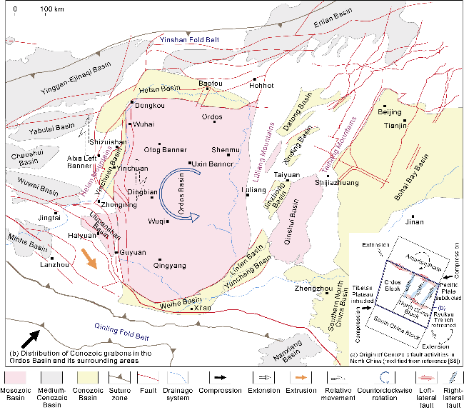
Fig. 6. Schematic diagram of tectonically reworked "residual Ordos Basin". |
As the carrier of material extrusion from the northeastern margin of the Tibetan Plateau and the westward subduction of the Pacific Ocean, the Ordos Block and its neighboring areas were subjected to NE-SW compression[67-68]. At the same time, affected by the retreat of the Philippine Plate under the Ryukyu Islands, the North China Block was subjected to NW-SE tension (Fig. 6a). Under the regional dynamic action, a series of parallel conjugate faults (left-lateral faults in near E-W direction and right-lateral faults in near N-S direction) adjusted the interacting forces among the surrounding plates, resulting in the counterclockwise rotation of the Ordos Block and the formation of the peripheral rift system.
4. Superimposed evolution of the Ordos Basin in different geological periods
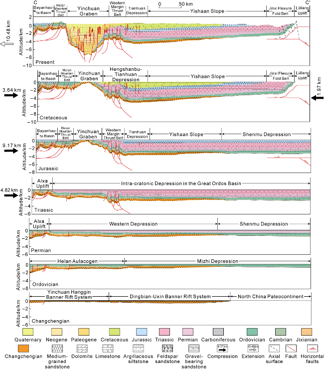
Fig. 7. Tectonic evolution on profile G2022-07 in the Ordos Basin (see the profile location shown in Fig. 1). |
In the Mesoproterozoic Changcheng Period, rift systems such as Bayan Obo, Yinchuan-Hanggin Banner, Dingbian-Uxin Banner, Longdong, Tongchuan, and Xiong’er were developed, showing a "wide-rift" structure (Fig. 3). The G2022-07 profile passes through two rift systems: Yinchuan-Hanggin Banner and Dingbian-Uxin Banner. The sedimentary thickness of these rift systems is 2 000 m to 4 000 m. In the Longdong area in the southwest of the basin, according to the interpretation of three-dimensional seismic data, it is inferred that the Longdong rift system is 4 000 m to 6 000 m thick. These rift systems have a typical "basin under the overlying Phanerozoic basin" structure. The sedimentary range narrowed in the Jixian Period, and the Yinchuan-Hanggin Banner Depression was developed. From the Qingbaikou Period to the Sinian Period, the central and eastern parts were uplifted into a North China Paleoland erosion zone.
In the Ordovician, sediments covered the whole Ordos Basin. Along the G2022-07 profile, the range of the Mizhi Depression in the east expanded rapidly under the control of regional sea level rise and subsidence, including the Dingbian Depression in the Cambrian. The Helan Aulacogen continued to develop.
After 120 million or even 200 million years of Caledonian Movement, the whole basin was almost flattened. In the Carboniferous, coal-bearing structures once again covered the whole area, and the Permian was stable depression deposits (Fig. 4). The western end of the G2022-07 profile is the Alxa Uplift, the western depression covers the Helan Mountains and Dingbian Depression, and the eastern part is the Shenmu Depression.
By the Triassic, a unified “Ordos Depression Lake Basin” was formed [19,20,22 -23,66] (Fig. 5), with sediment thickness of 1 500 m to 2 500 m. The western boundary is the Alxa Uplift (Fig. 7). At the end of the Triassic, along the G2022-07 profile, the western end was shortened by 4.82 km, indicating a compression movement at the end of the Indosinian period [23,60].
The Jurassic was important for structural differentiation of the Ordos Basin. Along the G2022-07 profile, from west to east, there are tectonic units such as the Bayanhaote Basin, Helan Mountain Thrust Belt, Yinchuan Anticline, West Margin Thrust Belt, Tianhuan Depression, Yishaan Slope and Shenmu Depression. The West Margin Thrust Belt is the front-edge reverse thrust belt of the large-scale thrust system on the west side. The Yinchuan Anticline is at the highest position. The Helan Mountain Thrust Belt is a basement-involved slip-thrust imbricate tectonic belt, and the Bayanhaote Basin is a piggyback basin. Late Jurassic compression shortened the basin by 9.17 km on the G2022-07 profile.
Relatively thick fluvial-lacustrine deposits accumulated in the Early Cretaceous. The sedimentary range became small (as shown by the Cretaceous pinch-out line in Fig. 5), and the sedimentary center was distributed in the Hengshanbu-Tianhuan Depression (Fig. 7). Overlapping deposits can be seen in the Hengshanbu area on the western thrust belt developed in the Jurassic. After the Late Cretaceous, the basin was uplifted and eroded. In the eastern part of the basin, due to the westward wedging of the deep structural wedge in the Lüliang Mountain area, the shallow formations became the Jinxi Flexure Fold Belt. In terms of the shallow formation, the G2022-07 profile was shortened by 1.97 km, and uplifted by 3.55 km [52]. However, the endpoint of the deep structural wedge spread westward by 30-35 km. The difference between the deep and shallow shortening is ascribed to the erosion of the large-scale shallow folds in the Lüliang Mountain area. The Cretaceous structural pattern of the western part of the basin inherited the characteristics of the Jurassic. It’s shortened by 3.64 km on the G2022-07 profile. In the Late Cretaceous, the Ordos Basin had a duplex structure in the east and west directions.
In the Cenozoic, the Yanshanian peripheral thrust system disintegrated and reversed [24,67]. Along the G2022-07 profile, after long erosion, the Yinchuan anticline reversed into a graben that extending 10.48 km. Its main body fell with the eastern foot fault of the Helan Mountains and Yellow River Fault, and was filled with 4-10 km thick fluvial-lacustrine sediments. The displacement of the eastern foot fault is large, making the entire graben half rotate under simple shear. Located on the shoulder of the Yinchuan Graben, the Helan Mountains were rapidly tilted, uplifted and eroded. The Cenozoic is missing in the main part of the Ordos Basin (Fig. 7).
As mentioned above, the Ordos Basin, on the Archean-Paleoproterozoic crystalline basement, has experienced four extension-convergence cycles: Mesoproterozoic extension-late Neoproterozoic compression, Cambrian- Middle Ordovician extension-Late Ordovician-Devonian compression, Carboniferous-early Late Triassic extension-late stage of Late Triassic compression, and Early-Middle Jurassic extension-Late Jurassic-Quaternary compression [26]. It was a marine cratonic basin covering the entire Ordos Block in the Mesoproterozoic-Ordovician, a marine-continental transitional depression basin confined by the Carboniferous-Permian plate margin island arc uplift belt, a unified intra-continental lacustrine basin in the Middle and Late Triassic, and a residual cratonic basin surrounded by the Cenozoic rift system. The present basin is the superimposition of all those basins [23-24,54 -55] (Fig. 1).
5. Significance of oil and gas exploration
The Ordos Basin has different ranges and structural attributes in different geological periods, which is an important geological feature of the basin, and contains rich information. (1) Each cycle or structural-stratigraphic sequence has its own unique source-reservoir-cap combination and oil (or gas) system [3,7,24], such as the Mesoproterozoic-Neoproterozoic, the Cambrian-Middle Ordovician, the Upper Carboniferous-Permian, the Middle-Upper Triassic, and the Jurassic-Tertiary oil and gas systems. Each system is a whole petroleum system rich in conventional and unconventional hydrocarbons [70]. Therefore, the exploration idea for each structural cycle (or structural layer) is unique. (2) On the superimposed interface of different tectonic cycles, oil or gas can migrate across layers and accumulate across time. This could form a set of reservoir combinations that are different from the upper and lower oil and gas systems, such as the large channel sand oil reservoir at the bottom of the Jurassic, the dolomite weathering crust gas reservoir at the top of the Ordovician, and the bauxite gas reservoir at the bottom of the Carboniferous. In the Qingyang Uplift, weathered crust gas reservoirs were found at the top of the Cambrian-Ordovician or Jixian System [6]. Vertically, a multi-layer three-dimensional oil and gas accumulation system was formed with "oil at the top and gas at the bottom". (3) The lateral distribution of oil- and gas-bearing areas in each tectonic cycle or their superposition is obviously different. In particular, oil and gas boundaries in different formations are restricted by the original basin range, rather than the present basin boundaries or mineral right lines. This is of great significance for future oil and gas exploration in the Ordos Basin.
During the Mesoproterozoic Changcheng period, a wide-rift system was developed (Fig. 3) [23]. With sedimentary thickness of 1 000 m to 6 000 m, it can be figuratively called "a basin under the overlying Phanerozoic basin". The prospect of oil and gas exploration in the Mesoproterozoic and Neoproterozoic is promising, and the focus in the future is to confirm the distribution of the Cuizhuang Formation source layer and its corresponding source-reservoir combination. The Cambrian- Ordovician craton passive margin underwent strong transformation, but the upper slope of the passive continental margin has been preserved. The dark mudstone source rock of the Middle Cambrian Xuzhuang Formation, the bio-mound beach reservoir rock of the Middle Cambrian Zhangxia Formation and the Upper Cambrian Gushan Formation-Fengshan Formation constitute the source-reservoir combination, which has favorable conditions for hydrocarbon accumulation. The black shale of the Ordovician Pingliang Formation and the Wulalike Formation on the western margin is a favorable source rock. And it forms a favorable source-reservoir combination with the dolomite of the Zhuozishan Formation and the Kelimoli Formation. The Wulalike Formation itself can form shale oil and gas on a scale of trillions of cubic meters [3,9 -10]. In the Cambrian intra-cratonic depressions, the Shenmu-Qingshuihe, Fuping-Luochuan, Dingbian and other rifts may develop [18]. Low-energy sediments inside the rifts and high-energy sediments on the rift shoulders constitute a lateral reservoir-source-reservoir combination, which is worth exploring. In the eastern part of the basin, the 1st, 3rd and 5th members of the Ordovician subsalt Majiagou Formation contain thin interbedded muddy and marly source rocks, which form an interbedded source-reservoir combination with the dolomite mound-shoal complexes in the 2nd and 4th members of the Majiagou Formation. Many wells such as Mitan1 and Mitan6 have proved that they constitute a favorable reservoir-forming combination with a reserve scale of trillions of cubic meters [3,7]. In the coal-bearing rock system in the Carboniferous-Permian intra-cratonic depression, breakthroughs have been made to tight sand gas, coalbed methane, shale gas, tight limestone gas, etc. in recent years. It is a typical coal-measure gas or mineral system [3-6]. Judging from the distribution of the prototype basin (Fig. 4), the Western Margin Fold-Thrust Belt, the Western Jinxi Flexural Fold Belt, the Yimeng Uplift, the Weibei Uplift, the Weihe Graben, the Yinchuan Graben and other tectonic units are all in the whole gas-bearing system [3]. The Qinshui Basin and the Cenozoic rift system between the Lüliang Mountains and Taihang Mountains are all exploration areas of this system. That is, any area of basin is gas-bearing. Regarding the Mesozoic large lake basin deposits, a new round of resource evaluation shows that the Mesozoic oil resources in the Ordos Basin are 263×108 t. This is a result obtained within the boundary of the traditional basin. Judging from its original basin distribution (Fig. 5), the oil resources should be larger than this result. For the Cenozoic Circum-Ordos Rift System (Fig. 6), the successful exploration of the Linhe Depression in the Hetao Basin has demonstrated the exploration potential [12], and the recent breakthrough to oil exploration in the Sanmenxia Basin has also demonstrated the exploration prospects of this area.
6. Conclusions
The Ordos Basin is a large sedimentary basin developed on the Ordos Craton formed in the Archean-Paleoproterozoic. The Ordos Block is bounded by the Engorwusu Suture Zone in the west, the Taihang Mountain Piedmont Fault Zone in the east, the Solonker-Xilamuron Suture Zone in the north, and the Shangnan-Danfeng Suture Zone in the south. The tectonic attributes of these boundaries are inconsistent in different geological periods.
The boundary of the Ordos Basin has been changing continuously during the geological history. From the Mesoproterozoic to the Early Paleozoic, it was a plate boundary, controlled by the Proto-Tethys Ocean and the Paleo-Asian Ocean on the south and north sides. The basin structure included the continental sea inside the craton, the slope of the craton margin and the deep-sea basin extending to the ocean-continent transition zone. In the Late Paleozoic, the island arc uplift zone at the edge of the plate formed the boundary of the depression basin in the marine-continental transition phase. In the Mesozoic, it appeared as a transition boundary between the peripheral uplift zone and a unified large-scale depression lake basin. In the Cenozoic, except for the compressional-torsion fault zone on the southwestern margin, the main boundary is the outer boundary of the circum Ordos rift system, mostly large-scale normal faults on the mountain side of the graben edge.
The present Ordos Basin is a composite basin superimposed by the sedimentary basins in different geological periods. It has experienced four extension-convergence cycles: the Mesoproterozoic extension-late Neoproterozoic compression, the Cambrian-Middle Ordovician extension-Late Ordovician-Devonian compression, the Carboniferous-early Late Triassic extension-late stage of Late Triassic compression, and the Early-Middle Jurassic extension-Late Jurassic-Quaternary compression. In the Mesoproterozoic-Ordovician, it was a marine craton basin covering the Ordos Block. In the Carboniferous-Permian, it was a marine-continental transitional depression basin confined by the plate edge island arc uplift belt. In the Middle and Late Triassic, it was a unified inland lacustrine basin. In the Cenozoic, it was a residual craton basin surrounded by rift systems. The basin range gradually decreased from original 160×104 km2 to 120×104 km2, then 100×104 km2 (in the Early and Middle Triassic) and 58.3×10⁴ km2, and until present 37×104 km2. In terms of the scale, the Ordos Basin far exceeded other sedimentary basins such as the Tarim Basin, Songliao Basin, Bohai Bay Basin in the geological history. It can be called a "Super (Pan) Ordos Basin".
The large prototype basin determines similar hydrocarbon/mineral geological conditions and accumulation assemblages for co-existing energy resources including oil, gas, coal, uranium, salt and helium. Three accumulation assemblages, namely Lower Paleozoic carbonates (or evaporites/shales), Upper Paleozoic coal-bearing strata, and Mesozoic sandstone-shale sequences, are distributed in whole or part of basin range from cratonic interior to margin. Exploration has extended far beyond the present residual basin, involving conventional and unconventional hydrocarbon resources and other energy minerals. Following a 3D multi-target-layer exploration strategy, the deep Mesoproterozoic wide rift system as a typical basin under the overlying Phanerozoic basin, the Cambrian-Ordovician passive continental margin, and the intra-cratonic depression will be successive targets for future exploration.