

Introduction
Since the Mesozoic, tensile and extensional rift systems have developed widely on a global scale [1]. The confined environment during the rift period resulted in the salinization and alkalization of sedimentary water bodies, making carbonate rocks often participate in the con-struction of rift sedimentary sequences. According to the differences in sedimentary environments, carbonate rocks of rifting stage are further classified into syn-rifting marine facies or lacustrine facies. Of them, syn-rifting marine carbonate rocks are characterized by stable lateral development and large longitudinal cumulative thickness. For example, in the Lusitanian Basin on the Iberian margin during the late Triassic-Jurassic [2], the thickness of carbonate rocks could reach 2 km. In contrast, the lacustrine basin environment during the rift period was more sensitive to tectonic activities, terrigenous input, changes in lacustrine level or hydrological conditions [3-6], which makes the development scale of lacustrine carbonate rocks during the rift period mostly smaller and the internal structures more complex [7-8]. The exception is that drilling and seismic data show that a rare set of massive carbonate rocks in the Cretaceous of the Santos Basin in Brazil, with a longitudinal thickness of up to 1 km and a plane distribution of more than 12 000 km2. Although predecessors have confirmed through data such as paleontological fossils [9-10], tectonic-sedimentary evolution [11-12], and geochemistry [13] that this set of carbonate rocks were developed in the lacustrine basin environment during the rift period, the platform evolution and the sequence-sedimentary process still need to be further clarified.
Since 2006, a series of major oil and gas exploration breakthroughs have been achieved in the deepwater subsalt lacustrine carbonate rocks of the Santos Basin in Brazil [14-16], making it a hot spot for oil and gas exploration in the global deepwater domains. Dou et al. [17] classified the subsalt lacustrine carbonate sedimentary system in the Santos Basin into two types of isolated platform construction patterns: the inter-depression faulted-uplift type and the intra-depression faulted-bulge type. The M block is located in the core oil-producing area in the northeastern part of the Central Depression Zone of the Santos Basin. It develops large integrated mound-shoal reservoirs and is rich in petroleum resources. It is a typical isolated platform of the inter-depression faulted-uplift type [17-18]. It is typically characterized by the large-scale development of mounds and shoals, with vertical thickness reaching 700 m. However, there is strong heterogeneity inside the reservoir due to the superimposed migration of multiphasic mounds-shoals and changes in the sedimentary microenvironment, which brings difficulties to fine exploration and development [15,19]. Therefore, one of the core tasks for oil and gas exploration in this set of lacustrine carbonate rock lies in revealing the superimposed migration laws and controlling factors of mounds-shoals, as well as the fine characterization of the cross-scale mounds and shoals [19-21]. This primarily relies on the accurate reconstruction of the lower sequence filling process and lithofacies paleogeography in the background of the fault-controlled isolated platform in the rift lake basin.
In view of this, based on the well logging data of 41 drilled wells (including 6 coring wells), over 500 thin sections, reservoir physical properties and three-dimensional seismic data in the M block of the Santos Basin, this study divided the platform carbonate sequences of the Itapema (ITP)-Barra Velha (BVE) Formation of the Lower Cretaceous and depicted the distribution of the sequence strata. The lithofacies paleogeography has been reconstructed by combining the analysis of sedimentary sequences and sedimentary environments, and then the superimposed migration laws of fault-controlled isolated platform lacustrine mounds and shoals are explored, and the distribution of favorable reservoir facies zones is clarified. The research results are expected to support the establishment of the geological model for the exploration of lacustrine isolated platform mounds and shoals, and provide a scientific basis for oil and gas exploration in the deepwater area of the Santos Basin and areas with similar geological backgrounds.
1. Geological setting
The mantle plume activities in the southern part of the Western Gondwana Continent during the Early Cretaceous led to the beginning of the stretching and rifting of the South American-African Plates, and the development of faulted basin groups on both sides of the rift [22-23]. Of them, the Santos Basin is located in the southeastern sea area of Brazil. It is bounded by the Cabo Frio Fault to the northeast, adjacent to the Campos Basin, and to the Florianopolis Fault to the southwest, adjacent to the Pelotas Basin. The basement faults in the Santos Basin are well developed, restricting multiple northeast-oriented tectonic units [24]. From land to sea, they are Western Depression Zone, A-Ulon Uplift Zone, Central Depression Zone, Lu-Sulon Uplift Zone and Eastern Depression Zone [25]. The M block is located to the north of the Lu-Sulon Uplift Zone (Fig. 1).
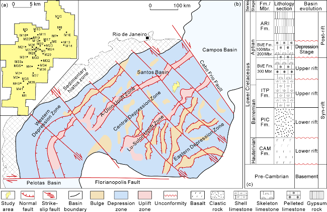
Fig. 1. Structural location and comprehensive stratigraphic column of M block in Santos Basin (modified after references [15,18]). (a) Well location distribution map of M block; (b) A simplified regional tectonic map of the Santos Basin; (c) Stratigraphic column of the Lower Cretaceous in the Santos Basin. |
In the early stage of syn-rifting, the Rio Grande Uplift- Walvis Ridge in the southern part of the basin blocked the exchange of water bodies between the basin and the ocean [26]. At this time, volcanic activity was intense, and regional basalt directly overlaid on the Pre-Cambrian metamorphic crystalline basement, developing the Camboriu (CAM) Formation [24]. The subsequently deposited Picarras (PIC) Formation is a fluvial-lacustrine sedimentary system, mainly depositing deep lacustrine shale and a small amount of sandstone. In the late stage of the syn-rifting, the Itapema (ITP) Formation deposited lacustrine shell limestone, marl and shale [23,27]. By the end of the syn-rifting, the basin underwent large-scale tectonic uplift, exposed erosion of the ITP Formation, and developed regional unconformity with the overlying Barra Velha (BVE) Formation. The BVE Formation is mainly composed of microbial carbonate deposits. There is a unconformity (Fig. 1) developed between the BVE300 Member and the BVE100-200 members, which serves as the boundary between the rift period and the depression period [28-29]. During the post-rift period, seawater began to invade. Due to the barrier effect and intense evaporation environment, a set of marine massive thick gypsum rocks of the Ariri Formation was deposited in the basin. At the end of the Early Cretaceous, the tectonic evolution of the basin entered the drift stage and transformed into passive continental margin deposition [14,24].
2. Sequence stratigraphic division and spatial distribution
2.1. Sequence division and boundaries
The Lower Cretaceous ITP-BVE formations are the most important horizons for the development of subsalt carbonate reservoir in the Santos Basin. Based on the seismic, coring, well logging and mud logging data, and referring to the existing sequence stratigraphic division schemes in the study area [18-19,30], four tertiary sequence boundaries (SB1-SB4) and three tertiary sequences (SQ1-SQ3, Fig. 2) were identified in the ITP-BVE formations.
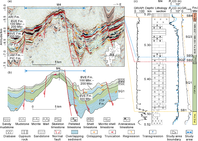
Fig. 2. Interpreted seismic-geological section and sequence stratigraphic profile of the Lower Cretaceous in M block of Santos Basin. (a) EW-trending seismic section through Well M4; (b) Interpreted EW-trending seismic section through Well M4; (c) Stratigraphic profile of the Lower Cretaceous sequence in Well M4. GR—Gamma ray; Rs—shallow resistivity; Rd—deep resistivity; GRInpefa—comprehensive error filtering analytical value. |
The bottom boundary of SQ1 (SB1) is the lithological unconformity between the ITP Formation and the underlying PIC Formation. The sediments below the SB1 are fluvial-lacustrine system such as sandstone, argillaceous siltstone and mudstone of the PIC Formation, and the top strata were exposed and denudated. The sediments above the SB1 are the overlying deposition of mud-sandstone mixed with pyroclastic rocks at the bottom of the ITP Formation, representing continuous lacustrine erosion, followed by the development of micrite, marl and shell limestone.
The SB2 unconformity was identified through the seismic response characteristics including truncation of SQ1 top and onlap of SQ2 bottom. The lithology beneath this interface is shell limestone, with a large number of moldic pores and small karst vugs. Above the interface, there is laminar marl and micritic pelleted limestone.
The top boundary of SQ2 (SB3) serves as the interface between the BVE300 Member and the BVE100-200 members within the BVE Formation. The seismic response characteristics are similar to those of SB2, but the range of top truncation is reduced and is only reflected in well areas M5 and M4, with poor lateral traceability.
The top boundary of SQ3 (SB4) is the lithological unconformity between the BVE Formation and the overlying Ariri Formation. The lithology above the interface is basin-scale thick evaporite rock. The seismic response shows a chaotic blank reflection. The lithology below the interface is microbial limestone, which is characterized by weak progradation reflection.
All SB1-SB4 in the area were exposed surfaces for a relatively long time. The interfaces are characterized by positive drift of GR curve and significant reduction in resistivity. In addition, the GR spectral characteristic curve (GRInpefa) indicates that the area above the interfaces is the initial lacustrine transgression.
2.2. Thickness distribution of stratigraphic sequences
Based on the above sequence division scheme and interface identification characteristics (Fig. 2), the sequence division and thickness statistics of stratigraphic sequences of 41 exploration wells in the study area were carried out by using seismic and well logging data. The contour maps of stratum thickness for SQ1, SQ2 and SQ3 sequences were compiled respectively (Fig. 3) to clarify the plane distribution characteristics of stratigraphic sequences in the study area.
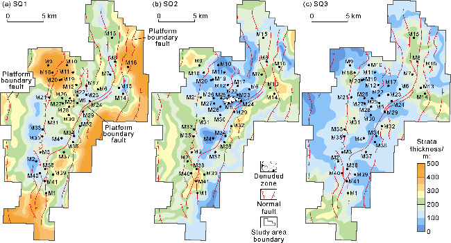
Fig. 3. Strata thickness distribution of the Lower Cretaceous SQ1-SQ3 sequences in M block of the Santos Basin. |
The thickness of SQ1 sequence is 50-500 m (Fig. 3a). Generally, it is thicker on the eastern and western sides and thinner towards the middle. The thick-value areas are concentrated on the outer edge of the fault at the platform boundary and well areas M9-M20 in the northwest. The thin-value areas in the central and western parts and the north are distributed in a strip-like pattern along the fault (Fig. 3a). The stratum thickness of the SQ2 sequence is relatively small (0-350 m) (Fig. 3b). Specifically, the stratum in the middle of the study area is the thinnest (only up to 100 m). It gradually thickens to about 350 m from the middle to the eastern and western sides, and then thins again to 150-200 m on the periphery. Generally, it is distributed in a strip-like pattern with alternating thicknesses along the faults nearly striking NS. Compared with SQ1, the strata around and in the middle of SQ2 become thinner, and well area M5 has been eroded and lost. Secondly, the range of the thick-value area in the northwest (well areas M9-M20) decreases and shows a tendency to migrate outward. The stratum thickness of SQ3 sequence is 0-300 m (Fig. 3c), with decreased thickness difference. Compared with SQ2 sequence, the range of the thin-value area in the middle of SQ3 has expanded, however the range of the thick-value area (well areas M9-M20) in the northwest further decreases. It is worth noting that near the faults in the well area M14 in the northern and eastern parts of the study area, the SQ3 sequence is as thick as 300 m. This is because that during the drifting stage of the basin, the magmatic rocks mainly composed of basalt intruded along the faults into the carbonate strata, presenting a limited distribution of thick interlayers (20-90 m) [31-32].
Generally, the thickness difference of the strata in the SQ1 to SQ3 sequences gradually decreases, and the thick-value areas in the northwest and periphery become thinner. The overall manifestation is that the strata were mainly distributed in a banded pattern under the control of faults in the early stage, but in a zoned pattern as the result of weakened influence of faults in the late stage.
3. Petrology and lithofacies sequence
3.1. Rock types
Core and thin section observations showed that six major types of rocks are developed in the study area. Of them, SQ1 sequence mainly develops shell limestone, shell-debris limestone and other bioclastic limestone. However, SQ2-SQ3 sequences are mainly composed of microbial rocks and granular rocks, including skeleton limestone, pelleted limestone, and arenaceous/rudaceous limestone.
3.1.1. Shell limestone
The grains that make up the shell limestone are mainly bivalves, with a small number of ostracode shells (Fig. 4a, 4b). The shells are well preserved, with length of 4-10 mm and thickness mostly greater than 0.5 mm. The rocks are characterized by moderate sorting and common horizontal overlapping arrangement. Micritic envelopes are developed around the shells, and the interstitial pores are semi-filled with argillite or micritic calcite. Occasionally, siliceous cemented fillings are observed. The shell limestone is formed near the base surface of lacustrine waves. After the death of bivalves, the shells piled up in place or migrated over short distances due to lacustrine wave action. According to the differences in the types and contents of interstitial materials, the shell limestone can be further classified into micritic shell limestone and argillaceous micritic shell limestone.
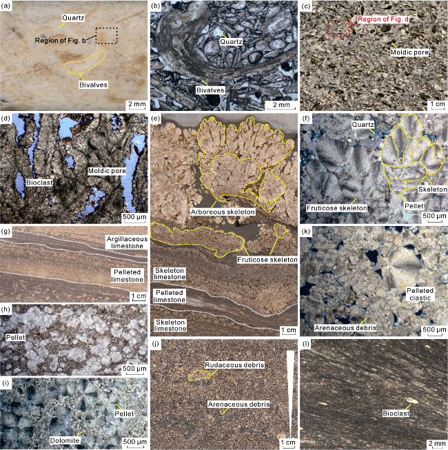
Fig. 4. Core and microscopic petrological characteristics of the Lower Cretaceous SQ1-SQ3 sequences in M block of the Santos Basin. (a) Well M5, 5 532.00 m, ITP Formation, shell limestone, intergranular siliceous cementation, wellbore coring; (b) Well M5, 5 532.00 m, ITP Formation, shell limestone, micrite envelopes, part of the shells are metasomized by siliceous matter, single polarized light, thin section; (c) Well M5, 5 340.05 m, ITP Formation, shell limestone, with moldic pores and intergranular dissolution pores, core; (d) Well M5, 5 340.05m, ITP Formation, shell limestone, bioclastic recrystallization, with intergranular dissolution pores and moldic pores, blue casts, single polarized light, thin section; (e) Well M12, 5 483.40 m, BVE200 Member, with interbedded shrub skeleton limestone and pelleted limestone at the bottom, biological skeletons grow upwards, developing fruticose skeletons, cores; (f) Well M31, 5 523.60 m, BVE300 Member, fruticose skeleton limestone, with elliptical pellets growing upward to form skeletons, orthogonal light, thin section; (g) Well M12, 5 575.80 m, BVE300 Member, with rhythmic interlayer of pelleted limestone and lamellar argillaceous limestone, core; (h) Well M31, 5450.45 m, BVE100 Member, pelleted limestone, intergranular filling of argillaceous permeable silts, single polarized light, thin section; (i) Well M12, 5 575.80 m, BVE300 Member, pelleted limestone, intergranular filling of dolomite grains and a small amount of insoluble residue, orthogonal light, thin section; (j) Well M12, 5 474.10 m, BVE200 Member, pebbled arenaceous limestone, with reverse grain sequence characteristics longitudinally, core; (k) Well M12, 5 571.75 m, BVE300 Member, arenaceous limestone, with pelleted fragments, orthogonal light, thin section; (l) Well M31, 5 845.00 m, ITP Formation, lamellar shell micrite, wellbore coring. |
3.1.2. Shell-debris limestone
The particles of the yellowish-brown shell-debris limestones are bivalve clasts, containing a small amount of ostracode clasts. The shells are randomly arranged, with better roundness and sorting. The shell grains are broken again under the action of waves, forming a high-energy sedimentary facies zone above the normal lacustrine wave base. Dissolved vugs and fractures are well developed in the core. Under the microscope, a large number of intergranular (dissolution) pores and moldic pores can be observed, which are semi-filled with sparry calcite or insoluble residues (Fig. 4c, 4d). Grain recrystallization or micritization is commonly observed.
3.1.3. Skeleton limestone
The skeleton limestone is composed of fiber-fan- shaped calcite vertically superimposed with radiating extinction, with upwardly-growing biological skeletons, which belongs to the microbial rock type. Pelleted deposits or dissolved vugs can be observed between the biological skeletons, with local semi-filling/filling of mud or insoluble residues (Fig. 4e, 4f). The longitudinal composite skeletons have multiple growth stages and can be further classified into three structural types based on the length-width-ratio: fruticose, arboreous and dendritic shapes [33-34]. The fruticose skeleton limestone is mainly developed along the beds and has clustered low dome- shaped structure. The arboreous skeleton limestone has larger clustered dome-shaped structure, and the top of the rock layer undulates irregularly. Compared with the first two types, the dendritic biological skeleton has the characteristics of being narrow, thin and long, showing a larger longitudinal growth scale. The larger the biological skeleton is, the higher the salinity of the lacustrine water body is reflected [34-35].
3.1.4. Pelleted limestone
Pelleted limestone is spherical to sub-spherical calcite aggregates with radiating extinction. Some pellets grow preferentially in a specific direction, presenting an asymmetrical shape with diameter of 0.1-2.0 mm. Locally, the pellets are dolomitized or recrystallized, with intragranular and intergranular dissolution pores. The intergranular spaces are filled with micritic and sparry dolomite and dark argillaceous or insoluble residues (Fig. 4g-4i). Pelleted limestone occurs in a lamellar or massive manner, often interbedded rhythmically with micrite/argillaceous limestone (Fig. 4g), and grows upwardly to transit into a fruticose shape (Fig. 4e, 4f).
3.1.5. Arenaceous/rudaceous limestone
The arenaceous and rudaceous matters are mainly irregular fragments formed by the re-deposition of pelleted limestone and skeleton limestone due to the fragmentation of lacustrine waves. The particles are rounded and sorted moderately. Longitudinally, it is characterized by reverse graded bedding, with intergranular or intragranular dissolved pores. The pores of the rock type are not filled or partially filled by vadose silt (Fig. 4j, 4k).
3.1.6. Micritic rocks
This type of rocks is in a relatively dark color and occurs in a laminated pattern. Under the microscope, it shows a micritic structure, and a small number of shells, pellets and other particles are suspended in the matrix. According to the component type and particle content, it can be further subdivided into rock types such as argillaceous limestone, micrite, shell-bearing micrite, shell micrite and pellet-bearing micrite (Fig. 4l).
3.2. Lithofacies sequence and sedimentary environment
Based on core interpretation and thin section observation, five high-frequency sequence lithofacies combinations were identified in the study area, indicating that SQ1-SQ3 are mainly shore-shallow lacustrine sedimentary environment, and the microbial mounds and granular shoals show multi-cycle superimposition characteristics (Table 1).
Table 1. Types and characteristics of sedimentary facies in Lower Cretaceous SQ1-SQ3 sequences of M block in Santos Basin |
| Shore-shallow lacustrine mud | Mudstone, micrite, pellet-bearing micrite, shell-bearing micritic marl, siliceous micrite | Horizontal beds, siliceous bands, siliceous nodules | |||
| Brackish water-saltwater lacustrine | |||||
| Shore-shallow lacustrine | |||||
| Microbial mound | (Fruticose/arboreous/ dendritic) skeleton mound | Fruticose skeleton limestone, arboreous skeleton limestone, dendritic skeleton limestone | Biological skeleton structure, skeleton pores, stromatolite structure | ||
| Pelleted mound | Pelleted limestone, micritic pelleted limestone | Laminated, ball-like crystal | |||
| Inter-mound | Pelleted micrite, pellet-bearing micrite, micrite | Lamellar fine-grained deposits between mounds | |||
| Granular shoal | Arenaceous/rudaceous shoal | Arenaceous limestone, rudaceous limestone | Inverse graded bedding | ||
| Shelly shoal | Shell limestone, micritic shell limestone, ostracoid limestone | Inverse graded bedding, ostracoid fossils, complete bivalve shells | |||
| Shell-debris shoal | Shell-debris limestone, micritic shell- debris limestone | Inverse graded bedding, bio-debris | |||
| Inter-shoal | Shell micrite, micritic shell-debris limestone, micrite, shell-debris micrite | Lamellar fine-grained deposits between shoals | |||
3.2.1. Typical sequence I: Marl/micrite-micritic shell limestone-shell limestone
This sequence is represented by the depth interval of 5 328.1-5 329.9 m in Well M5 (Fig. 5a), with marl/micrite at the bottom of the cycle. It is located in the shore- shallow lacustrine mud environment near the lacustrine wave base. The content of biological particles increases upwards, transitioning to thin micritic shell limestone. As the lacustrine level slowly dropped, bivalves thrived that the shells accumulated on the micritic basement to form low-energy shelly shoals. It resulted in superposition of multiphasic shelly shoals longitudinally. When the lacustrine level further dropped, the energy of the water body increased and shell-debris shoals deposited. This sequence represents the shore-shallow lacustrine mud/ inter-shoal-shelly shoal sedimentary environment.
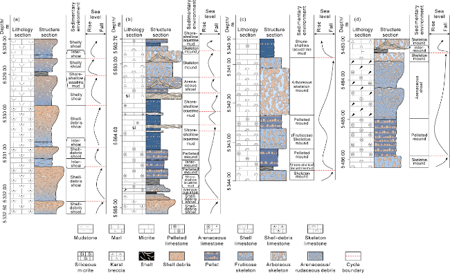
Fig. 5. Typical sedimentary sequences of the Lower Cretaceous SQ1-SQ3 in M block of the Santos Basin. (a) Well M5, 5 328.00-5 332.50 m, ITP Formation; (b) Well M20, 5 562.70-5 565.05 m, BVE300 Member; (c) Well M4, 5 340.10-5 344.00 m, BVE200 Member; (d) Well M12, 5 482.95-5 486.20 m, BVE200 Member. |
3.2.2. Typical sequence II: Micrite-micritic shell-debris limestone-shell debris limestone
This sequence is a typical type of SQ1 sequence, represented by the depth interval of 5 329.9-5 332.5 m in Well M5 (Fig. 5a). Thin micritic shell-debris limestone or micrite deposited at the cycle bottom with the relatively weak water energy is an inter-shoal depression deposition. As the lacustrine level dropped, the larger bivalve shells were broken under the action of lacustrine waves, rapidly accumulated and built up, forming high-energy shell- debris shoals. Some of the shoal tops were exposed above the lacustrine level and were subject to the leaching of atmosphere freshwater, developing dissolution vugs and fractures. This sequence represents the inter-shoal-shell- debris shoal sedimentary environment.
3.2.3. Typical sequence III: Mudstone/marl-pelleted limestone-siliceous micrite/siliceous breccia
This sequence is represented by the depth interval of 5 562.70-5 565.05 m in Well M20 (Fig. 5b). In the early stage of the slow rise of lacustrine level, the lacustrine waves stirred the semi-consolidated sediments. Thin arenaceous limestone could be formed at the cycle bottom, forming interbedded dark laminated marl. The water body became shallower upwards and transited into laminar pelleted limestone. The cycle top had insufficient accommodation space, which resulted in the deposition of pellet-bearing micrite and micrite with interbedded light and dark rhythms. Upwardly, the content of argillaceous matter increases, and local siliceous bands and aggregates are observed due to the exposure and development of karst breccia or volcanic activities [36]. This sequence represents the sedimentary environment of the shore-shallow lacustrine mud-pelleted mounds.
3.2.4. Typical sequence IV: Mudstone/marl-pelleted limestone-skeleton limestone
This sequence is represented by the depth interval of 5 340.4-5 344.0 m in Well M4 (Fig. 5c). At the cycle bottom, there is marl/micrite, located in a low-lying area between mounds or in sedimentary environment of shore-shallow lacustrine mud. As the lacustrine level rose, the accommodation space increased. Upwardly, laminar pelleted limestone-fruticose skeleton limestone-arboreous skeleton limestone were developed successively. The biological skeleton extended horizontally to longitudinally. The skeleton mounds at the top were rapidly built, but due to insufficient accommodation space, it transformed into fruticose skeleton limestone with smaller biological skeletons. This sequence represents the sedimentary environment of shore-shallow lacustrine mud/ inter-mounds-pelleted mounds-fruticose skeleton mounds- arboreous skeleton mounds.
3.2.5. Typical sequence V: pelleted limestone-arenaceous limestone-arboreous skeleton limestone
This sequence is represented by the depth interval of 5 482.95-5 486.20 m in Well M12 (Fig. 5d). The lower part of the cycle is composed of laminar pelleted limestone, which is rhythmically interlayered with micritic pelleted limestone, alternating in light and dark. The pelleted limestone and skeleton limestone that were deposited in the middle of the cycle were broken and rapidly accumulated under the action of lacustrine waves. It formed arenaceous/rudaceous shoals, with superimposed multiphasic shoals longitudinally. Upwardly, lacustrine level continuously dropped. The water body was limited, and arboreous skeleton mounds were developed. The top skeleton pores were often filled by the mud of the next cycle of rapid lacustrine transgression. This sequence represents the sedimentary environment of shore-shallow lacustrine mud/inter-mounds-pelleted mounds-arenaceous/rudaceous shoals-skeleton mounds.
The SQ1 sequence in the study area is mainly composed of bioclastic shoals, with a typical microfacies combination sequence of shore-shallow lacustrine mud-low- energy shelly shoal-high-energy shell-debris shoal, and the water body energy gradually increased. During the Early Cretaceous, the Santos Basin was in a subtropical hot and dry climate [22], with continuous water evaporation. In addition, previous researchers believed that based on the changes in the shape of ostracode biota, it gradually evolved into a salinized alkaline lacustrine [10]. In the SQ2-SQ3 sequences, the ostracode biota were no longer developed, which was speculated to be related to the increase in water salinity [10,37]. At the same time, with the decline of lacustrine level, a typical microfacies combination sequence of shore-shallow lacustrine mud-pelleted mounds-arenaceous/rudaceous shoals-skeleton mounds was developed, and a set of microbial-arenaceous/rudaceous mound-shoal complexes was deposited.
4. Sequence lithofacies paleogeography reconstruction and distribution of sequences
4.1. Sequence sedimentary facies analysis under the constraints of multiple wells
Sedimentary facies was analyzed based on the well logging and mud logging data of core calibration, and the well-tie sedimentary facies profile was constructed (Fig. 6). The results showed that in the nearly-NS trending profile (Fig. 6a), the middle part of the SQ1 sequence is generally thick, with large-scale shell-debris shoals. The strata on both the northern and southern parts become thinner and transit into small-scale shelly shoals. From the southernmost (Well M1) to the northernmost (Well M8), thick basalts are developed at the lower part, however, marls are deposited in the upper part, with poorly- developed shoals in sedimentary environment of shore- shallow lacustrine mud. The strata in the middle of the SQ2 sequence become thinner due to erosion and thicker towards both the north and south sides. Arenaceous/ rudaceous shoals and skeleton mounds are developed in the central and northern parts. However, pelleted mound and arenaceous/rudaceous shoals are developed in the south. The lateral distribution of sedimentary facies in the SQ3 sequence is consistent with that in the SQ2 sequence. However, thin to thick diabase are developed in the area from Well M4 in the middle to Well M8 in the north, which are interlayered in the carbonate strata or located at the top of the SQ3 sequence, showing relatively wide plane distribution.
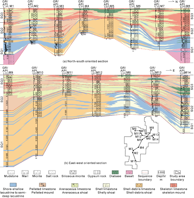
Fig. 6. Well-tie section of the Lower Cretaceous sedimentary facies in M block of the Santos Basin. |
In the nearly-EW profile (Fig. 6b), the strata on the western part of the SQ1 sequence are thick. The seismic response shows a hummocky blank reflection, which is a large set of shell-debris shoal. The strata are thinned to the east, the scale of shoals decreases as well. It gradually evolves into shelly shoals and shore-shallow lacustrine mud. The middle part of the SQ2 sequence is generally thin and develops arenaceous/rudaceous shoals. The strata are thickened towards both sides and transit into pelleted mounds. The middle part of the SQ3 sequence develops arenaceous/rudaceous shoals and skeleton mounds, evolving to both sides into large-scale arenaceous/rudaceous shoals and pelleted mounds. Compared with the SQ2 sequence, the water energy was enhanced. In addition, the SQ3 sequence also develops thin-thick diabase, which mostly intrudes into the carbonate strata along lamina and is concentrated in well areas M11-M14. Compared with the nearly-NS profile, the distribution of diabase is limited and is in a point pattern.
4.2. Sequences lithofacies paleogeography distribution
Based on the single-well lithofacies sequence and well-tie sedimentary facies correlation, the single-factor comprehensive mapping method and the principle of dominant facies were applied to reconstruct lithofacies paleogeographic maps of SQ1-SQ3 sequences (Fig. 7). The results showed that the sedimentary facies of the SQ1 sequence develop sequentially outwards, including shell-debris shoals, shelly shoals, shore-shallow lacustrine mud and semi-deep lacustrine, roughly in a Y-shaped “ring type” distribution. Overall, it presents a sedimentary pattern of shallow-water isolated carbonate platforms surrounded by relatively deepwater on all sides (Fig. 7a). This isolated platform is characterized by the development of large-scale granular shoals. The middle part is a relatively high-energy shell-debris shoal facies composed of shell-debris limestone, micritic shell-debris limestone, etc. The periphery transits into a shelly shoal facies composed of micritic shell limestone. Overall, it shows a distribution pattern of "inner shell-debris shoal and outer shelly shoal". Of them, the shoals in the northwest and middle are larger, and become smaller towards the outside. The northeastern shoals are sporadically developed (Fig. 7a). Outward from the granular shoal facies zone on the isolated platform, it is speculated that it gradually transits to the shore-shallow lacustrine facies and semi-deep lacustrine facies composed of low-energy fine-grained sediments [38].
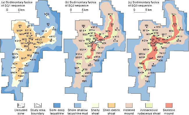
Fig. 7. Lithofacies paleographic maps of the Lower Cretaceous SQ1-SQ3 sequences in M block of the Santos Basin. |
The SQ2 sequence, on the basis of inheriting the paleogeographic pattern of the SQ1 sequence, is characterized by a mound-shoal complex composed of newly-built microbial mounds and granular shoals on the isolated platform (Fig. 7b). The middle part develops a skeleton mound facies composed of arboreous skeleton limestone and fruticose skeleton limestone, which is roughly distributed in a curved band from NNE direction to SSW direction. To the outside, it successively transits into arenaceous/rudaceous shoal facies composed of arenaceous and rudaceous limestone, as well as pelleted mound facies composed of pelleted limestone and laminar fruticose skeleton limestone. This thus forms a ring-shaped distribution pattern with the skeleton mounds as the core, surrounded by arenaceous/rudaceous shoals and pelleted mounds. Outward from the isolated platform mound-shoal complex, it is speculated that it gradually transits into shore-shallow lacustrine facies composed of low-energy fine-grained sediments. Compared with the SQ1 sequence, the SQ2 sequence is not only characterized by the development of microbial mounds, but also the mounds and shoals undergo lateral migration and progradation, and the scale expands significantly outward.
The SQ3 sequence basically inherits the paleogeographic pattern of the SQ2 sequence (Fig. 7c). On the isolated platform, it is characterized by the construction of a mound-shoal complex composed of microbial mounds and granular shoals, and continues to show a “ring type” distribution of skeleton mounds-arenaceous/ rudaceous shoals-pelleted mounds. The skeleton mound facies distributed in a curved band in the middle shows an expanding trend, the arenaceous/rudaceous shoal facies slightly contracts, and the pelleted mound facies is mainly developed at the outer edge. Outward from the isolated platform mound-shoal complex, it is speculated that it gradually transits into shore-shallow lacustrine facies composed of low-energy fine-grained sediments, while the semi-deep lacustrine facies basically disappears.
The SQ1-SQ3 sequences on the isolated platform show an evolution trend from granular shoal to mound-shoal complex. The SQ1 sequence presents a “ring-shaped” distribution of "shell-debris shoal inside and shelly shoal outside". However, the SQ2 and SQ3 sequences are characterized by a “ring type” distribution of skeleton mounds-arenaceous/rudaceous shoals-pelleted mounds. The periphery of the isolated platform is speculated to be mainly composed of low-energy fine-grained sediments in the shore-shallow lacustrine facies and semi-deep lacustrine facies [38].
5. Discussion
5.1. Stratigraphic sequence filling process of fault-controlled isolated platform
Under the influence of the splitting of the West Gondwana Continent, the study area presents the structural geomorphic characteristics of a rift with alternating SN-trending grabens and horsts [17]. During the rift period, due to frequent tensional extension, faults were active and the landform was variable. Of them, the M block features typical fault-controlled isolated platform landform. Active basement normal faults running through the north and south are developed on both the east and west sides, controlling the landform and thereby influencing the differentiation of sedimentary facies and stratum thickness (Fig. 3 and Fig. 8). The thicknesses of the strata on both sides of the active faults vary significantly. The stratum thickness of the outer downthrown side of faults is large, however, that of the inner upthrown side of faults gradually thins due to the gradual overlying of the strata (Fig. 8). It can be concluded that the M block developed a tectonic paleogeomorphic pattern with a bulge in the middle and sags around the periphery before the SQ1 sequence sedimentation, which was an isolated highland under the control of faults. Since the SQ2-SQ3 sequences, carbonate deposits in microbial mounds and high-energy arenaceous/rudaceous shoal facies were developed on the isolated platform at the inner side of the boundary faults and filled into the sag zones in prograding style. However, on the outer side of the boundary faults, low-energy fine-grained sediments such as shore- shallow lacustrine to semi-deep lacustrine argillaceous (limestone) rocks are dominated (Fig. 7).
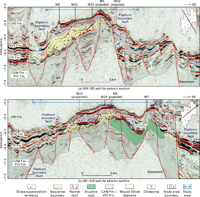
Fig. 8. Well-tie seismic section of M block in the Santos Basin. |
Inside the platform, active faults further control the filling process of stratigraphic sequences of carbonate rock, specifically manifested as the differences in stratum thickness within the platform range of the SQ1 sequence and the SQ2-SQ3 sequences. Of them, the SQ1 sequence shows that it is thicker in the middle and thinner around the periphery, presenting a centralized distribution. However, when entering the SQ2-SQ3 sequences, it gradually becomes thinner in the middle and thicker around the periphery, following a "ring shaped" distribution (Fig. 3).
Based on the distribution of stratum thickness and lithological characteristics in different periods, it was found that in the SQ1 sequence deposited under the background of lacustrine intrusion [10,22], the areas with thick strata have low GR values, shell limestone, hummocky uplift of the seismic response, and the internal chaotic reflection. It is speculated that it belongs to a sedimentary area mainly composed of granular shoals. In the areas with thin strata, there are high GR values and marl deposits, which belong to the low-energy sedimentary area. Analysis suggests that the thick-value area in the middle is composed of carbonate buildup in shoal facies, while the thin-value area around it is the shoal wing and the low-energy sedimentary area of the shore-shallow lacustrine facies (Fig. 6), thus forming a centralized distribution. Entering the SQ2-SQ3 sequences, it turned into a continuous lacustrine regression background [10]. In the internal thin-value areas, there are local exposed erosion and stratum loss phenomena with low GR values. These areas develop arenaceous limestone and stromatolitic limestone, being mound-shoal complex sedimentary areas. The thick-value areas in zoning domain have low GR values, with mound-shoal complex deposits mainly composed of arenaceous limestone and microbial rock. The thin-value areas around the periphery show high GR values, with an increased proportion of marl, presenting a relatively low-energy sedimentary environment (Fig. 6). Based on this, it is believed that the relatively reduced accommodation space is the main reason for the lateral migration of mounds and shoals, thus forming a “ring-shaped” stratum distribution pattern.
By comparing the SQ1 sequence and SQ2-SQ3 sequences, it is found that the stratum thickness and sedimentary facies in the northwest and northeastern regions of the study area vary greatly. It is considered that the local difference in subsidence or uplift caused by the syn-sedimentary tectonic activities is the reason. Considering the volcanic eruptions at the end of the SQ1 sequence, relatively active tectonic activities [31-32,39], and the significant thickness differences on the northwest side, as well as the large thickness differences in well areas M9 and M20 on both sides of the faults (Fig. 8a), it is believed that active faults were developed in the core of the pre-existing northwest highland, which in turn led to lateral subsidence and an increase in the accommodation space. Secondly, the sedimentary facies in the northeastern part (well areas M8-M15) changed from shore-shallow lacustrine mud to mound-shoal complex deposits (Fig. 7b-7c), indicating that the water energy in this area significantly increased. Combined with the eruption rocks in the northeastern strata, the analysis suggests that the eruption of magma at the sedimentation end of the SQ1 sequence adjusted the landform, caused the northeastern part to merge with the central and southern parts, and expanded the range of bugles (Fig. 8b).
Overall, the basement faults of the rift control the formation of isolated highlands. Accompanied by lacustrine transgression onlapping of SQ1 sequence, later progradation of SQ2-SQ3 sequences in lacustrine regression period, the platform scope gradually expanded on the basis of inherited development. In addition, the syn-sedimentary tectonic activities also adjusted the local landforms and controlled the evolution of sedimentary period landforms characterized by "subsiding in the northwest and uplifting in the northeast".
5.2. Mound-shoal superimposed migration model in fault-controlled isolated platform
Under the geomorphic control of the syn-rift period, the fault-controlled isolated platform provided a narrow shallow-water basement striking in nearly north-south direction for the development of carbonate rocks, with a planar scale of approximately 25 km ×15 km. During the development stage of fault-controlled isolated platform, the relative fluctuation of lacustrine level and the geomorphic evolution controlled by syn-sedimentary faults affected the development and distribution of mounds and shoals [4]. The continuous extension of the rift led to the accelerated subsidence of the basin. Coupled with increased rising rate of lacustrine level [10,22], it further controlled the formation of bioclastic shoals to only accumulate in local highlands within the platform. Combining the distribution of sedimentary facies (Fig. 7) and the seismic response characteristics of the mounds and shoals (Fig. 2 and Fig. 8), it is believed that the shell-debris shoals were developed in the core of the SQ1 sequence at the highlands, transited to the shelly shoal in the slope break zone, and the bioclastic shoal rapidly accumulated and built up within the platform [30].
To the sedimentary period of SQ2-SQ3 sequences, the paleogeomorphic adjustment of "northwest subsiding and northeast uplifting" controlled by syn-sedimentary tectonic activities led to the expansion of the isolated platform range, coupled with the background of continuous lacustrine regression [10]. The accommodation space of the highland within the platform was insufficient, and the mounds and shoals were stacked and relocated to the lateral wings. With the buildup of arenaceous/rudaceous shoals in the slope break zone, the water circulation in the highland within the platform was restricted, promoting the growth of halophilic skeleton mounds [34-35]. As the lacustrine level further dropped, the mounds and shoals ceased to grow as the exposure from lacustrine surface, and the local landform highlands were eroded.
Similar reports of lacustrine carbonate mounds and shoals have also been made in other areas of the Lu-Sulon Uplift Zone. The isolated platform of the H Oilfield was built on a horst enclosed by the tension-strike-slip faults, and the SQ2-SQ3 sequences have undergone an evolution from an early submerged platform to a late open platform [19]. Compared with M block, the overall paleogeomorphic terrain of H Oilfield was relatively low, and the lacustrine water was relatively deep, resulting in the transformation of the development of mounds and shoals into vertical aggradation and buildup. In addition, in the Campos Basin, during the late syn-rift period, there also existed the development characteristics of isolated platform mound- shoal with vertical aggradation under the background of lacustrine transgression and lateral migration in the background of lacustrine regression [6].
In conclusion, the lacustrine carbonate platform of the rift was formed in the relatively calm late stage of the syn-rifting period. The fault-controlled isolated highland was the shallow-water basement for the development of the carbonate platform and controlled the initial morphology and scale of the platform. During the growth stage of isolated platform, the changes in accommodation space, lacustrine level and landform adjustment caused by faults affected the development and distribution of the mounds and shoals within the platform. Ultimately, under the conditions of weakened terrigenous interference and saltwater evaporation of lacustrine water [10], fault-controlled isolated platform lacustrine shoal-mound development model was formed, which was characterized by vertical aggradation and buildup of shoals in the SQ1 sequence and lateral migration of mound-shoal complex in the SQ2-SQ3 sequences (Fig. 9).
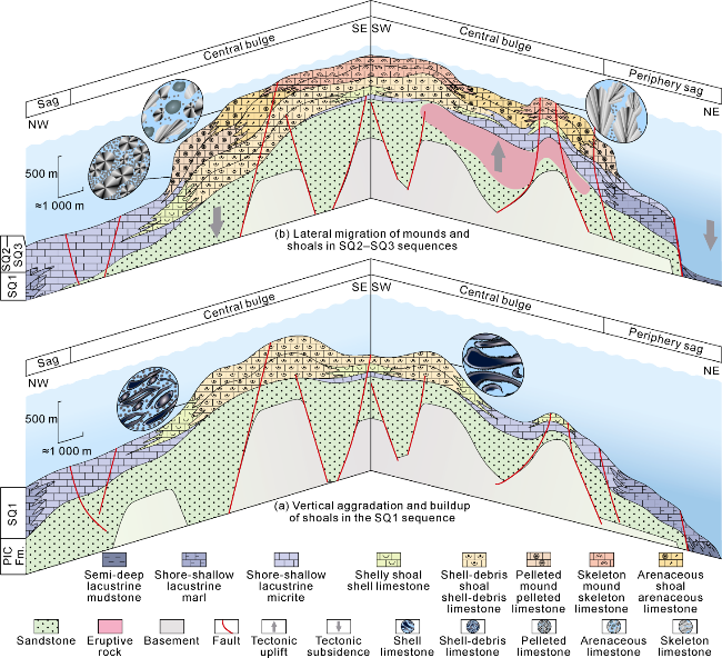
Fig. 9. Development and evolution model of lacustrine mounds and shoals in fault-controlled isolated platform in M block, Santos Basin. |
5.3. Superimposed migration of platform mounds and shoals controls the spatiotemporal distribution of reservoirs
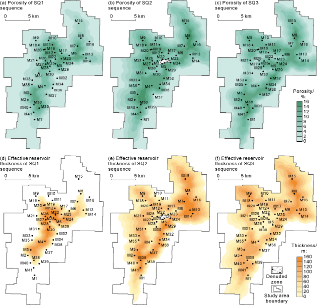
In recent years, significant breakthroughs in oil and gas exploration have been achieved in Cretaceous rift lacustrine carbonate rocks in deepwater areas such as the Santos Basin and Campos Basin in southeastern Brazil, and the Kavanaza Basin and Congo Basin in western Africa [40-42]. Exploration experience shows that the lacustrine carbonate reservoirs in the rift are mainly granular limestone and microbial rocks, and various storage spaces such as intragranular dissolution pores, moldic pores (Fig. 4d), intergranular (dissolution) pores (Fig. 4l), and skeleton (dissolution) pores (Fig. 4f) are developed. There are significant differences in reservoir performance[43-44]. The evolution and distribution of sequence lithofacies paleogeographic patterns are the key factors controlling the differential development and distribution of reservoirs. The analysis results of the reservoir physical properties show that the M block mainly develops porous reservoirs (Fig. 9). Of them, the shell-debris limestone reservoirs of the ITP Formation have extremely good physical properties. Samples with porosity greater than 10% account for 71.2%, and samples with permeability greater than 10×10−3 μm2 account for 56.6%. The physical properties of the arenaceous/rudaceous limestone reservoir in the BVE Formation are the best, with an average porosity of 12.8%. Samples with porosity greater than 10% account for 66.3%, and samples with permeability greater than 10×10−3 μm2 account for 41.3%. The physical properties of the skeleton limestone are relatively poor, followed by the pelleted limestone (Fig. 10). From the perspective of the porosity distribution of the reservoir, the lithofacies paleogeographic distribution pattern of sequences controls the differential distribution of mounds and shoals, which is consistent with the differences shown in the analysis of reservoir physical properties. The results suggest that the facies zone distribution pattern of "internal shell-debris shoal and external shelly shoal" in the SQ1 sequence controls the distribution pattern of higher porosity in the middle and lower in the outer side of the reservoir (Fig. 11a). However, the SQ2-SQ3 sequences develop a “ring shaped” distribution of skeleton mounds- arenaceous/rudaceous shoal-pelleted mounds, controlling the “ring shaped” distribution in the areas with high porosity (Fig. 11b, 11c).
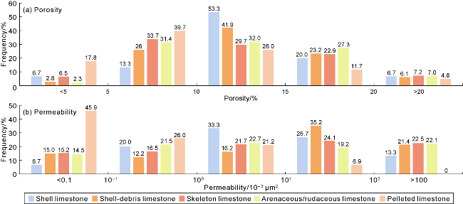
Fig. 10. Physical property characteristics of various reservoir rocks in the Lower Cretaceous SQ1-SQ3 sequences of M block in the Santos Basin. |
Fig. 11. Porosity and plane distribution of porosity and effective reservoir thickness of Lower Cretaceous SQ1-SQ3 sequences in M block of Santos Basin. |
As mentioned earlier, paleo-landforms and sea level fluctuations jointly controlled the migration of mounds and shoals beneath the sequence framework. From the perspective of the distribution law of effective reservoir thickness in each sequence, the high-quality reservoir facies zones are mainly distributed in the high parts and slope break zones of the landform within the platform. It is believed that the evolution and distribution of the sequence lithofacies paleogeographic pattern also further controls the differences in the scale of reservoir development. Firstly, during the sedimentation period of the SQ1 sequence, when the relative lacustrine level rose, a huge thick bioclastic shoal was accumulated on the platform. The vertical aggradation of the shoals controlled the centralized distribution of the reservoir being "thick inside and thin outside" (Fig. 11d). During the sedimentation period of SQ2-SQ3 sequences, the scale of the bugles expanded. Accompanied by the continuous dropping of the lacustrine level, the mounds and shoals migrated laterally and superimposed, controlling the “ring shaped” distribution of the outward migration of the areas with large reservoir thickness (Fig. 11e, 11f). The analysis suggests that the migration law of mounds and shoals under the variation of lithofacies paleogeographic patterns controls the effective thickness changes from the centralized to the ring shaped distribution in SQ1-SQ3 sequences.
Overall, the lithofacies paleogeographic evolution of sequences is of vital importance to reservoirs. The development and superimposed migration of mounds and shoals in rift lacustrine facies (Fig. 9) jointly controlled the porosity and thickness distribution patterns of carbonate reservoirs in rift lacustrine facies from both "quality" and "quantity" aspects (Fig. 11). This study reveals the development pattern of the mounds and shoals in the deepwater area in the rift lacustrine facies and the distribution law of favorable reservoir facies zones. It is expected to support the establishment of the exploration geological model of the mounds and shoals in lacustrine isolated platform, and provide a reference for oil and gas exploration in the deepwater subsalt area of the Santos Basin and the regions with similar geological background.
6. Conclusions
The carbonate rocks of the Lower Cretaceous ITP-BVE formations in M block of the Santos Basin were developed on isolated platforms formed by early rift basement faults in the rift basin, and four tertiary sequence boundaries and three tertiary sequences were developed. The sedimentary period of SQ1 sequence was characterized by the paleogeomorphic feature of "thin in the center and thick in both sides", which controlled the overlap and filling of the strata towards the bugle. During the sedimentary periods of SQ2-SQ3 sequences, the syn-sedimentary faults triggered the paleogeomorphic adjustment of "northwest subsiding and northeast uplifting", accompanied by the drop of the lacustrine level and the expansion of the bugle scale.
On the fault-controlled isolated platform of shore-shallow lacustrine, the sedimentary facies of SQ1-SQ3 sequences show an evolution trend from granular shoals to mound-shoal complexes. The SQ1 sequence presents a distribution pattern of sedimentary facies zones with "internal shell-debris shoal and external shelly shoal". The overall lacustrine intrusion background and the higher accommodation space controlled the formation of the shoals that are chiefly vertical aggradation and buildup. The SQ2-SQ3 sequences show a “ring shaped” distribution of skeleton mound-arenaceous/rudaceous shoal-pelleted mound, characterized by the lateral migration of the mounds and shoals under the background of continuous lacustrine regression, low accommodation space and high salinity.
The superposed migration of the mounds and shoals on platform control the spatiotemporal evolution of the reservoirs. The high-quality reservoir rocks transform from the centralized distribution of shell/shell-debris limestone in the SQ1 sequence to the "ring shaped" distribution of arenaceous/skeleton/pelleted limestones in the SQ2-SQ3 sequences. The results of this paper highlight the reservoir control effect of lithofacies paleogeography of sequences and provide a research paradigm for the evolution of carbonate platforms and the superimposed migration law of mounds and shoals in rift lake basins.