

1. Proposal and scope of the Tethys Ocean and the Tethys Domain
Based on the distribution of Jurassic marine sedimentary formations from the Caribbean to Southeast Asia, Melchior Neumayr proposed the existence of a vast ocean in the Jurassic and named it the “Central Mediterranean” in 1885 [1]. In 1893, Eduard Suess renamed it the “Tethys Ocean” after the ancient Greek sea goddess [2]. Wu et al. [1] reviewed the research history of the Tethys and summarized the connotations of the Proto-, Paleo-, and Neo- Tethys Oceans. The Paleo-Tethys Ocean refers to the ocean between the northern continent (Laurasia) and the southern continent (Gondwana) during the Late Paleozoic, while the even older ocean within the Tethys Ocean is termed the Proto-Tethys Ocean (Fig. 1a-1b). The southward subduction of the Paleo-Tethys Ocean triggered back-arc breakup and expansion of Gondwana, giving birth to a new domain, i.e. the Neo-Tethys Ocean that flourished in the Mesozoic-Cenozoic [3] (Fig. 1c-1e). In the latest years, the threefold classification as Proto-, Paleo-, and Neo-Tethys has been widely adopted [1,4 -5] for the discussion of its evolution (Fig. 1). The major research program on “Tethys geodynamic system”, financially supported by the National Natural Science Foundation of China, defines the Tethys tectonic domain as the suture zones of the Proto-, Paleo-, and Neo-Tethys Oceans and their adjacent areas spanning from South Europe/North Africa to Southeast Asia/Australia [6]. This study falls within this defined framework. Compared with the Tethys Domain defined by Klemme and Ulmishek [7], the scope delineated in this paper, while not extending to southern North America and northern South America, significantly expands its coverage of Southeast Asia and Australia [1,8 -10] (Fig. 2). Based on the latest data from S&P Global [11] and BGR [12], this study estimates that the proved and probable (2P) reserves of conventional oil and gas within the Tethys Domain (all reserves-related data in this paper refer to 2P scale) amount to 3 545.97×10⁸ tons of oil equivalent (toe), accounting for 49.8% of the global total 2P conventional reserves. Notably, the distribution of oil and gas within the Tethys Domain is highly uneven. The southern Tethys Domain, despite covering only 31.6% of the total area, hosts 79.2% of the total reserves. Preceding efforts focused on the primary controls on hydrocarbon enrichment in the Tethys Domain from various perspectives, including the distribution of source rocks [7,13], basin types and preservation conditions [8,14], tectonism intensity and trap development [15], and time- space coupling of geological elements [16-17]. However, no consensus has been reached to date. Based on the latest oil and gas field/reservoir and basin data, this study employs an integrated basin analysis approach within the framework of Tethys Ocean evolution to investigate the time-space distribution of oil and gas resources and the controlling mechanisms for their differential enrichment in the southern Tethys Domain. Research findings offer valuable insights for uncovering the primary controls on differential hydrocarbon enrichment in the northern and central Tethys Domain as well as other enriched areas.
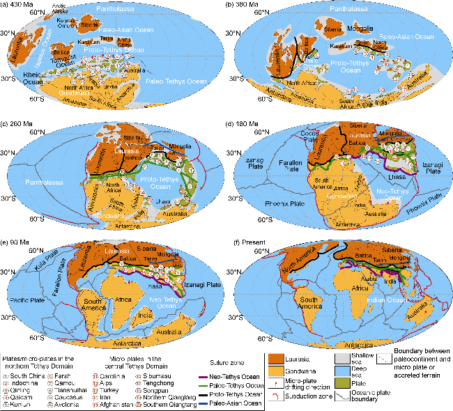
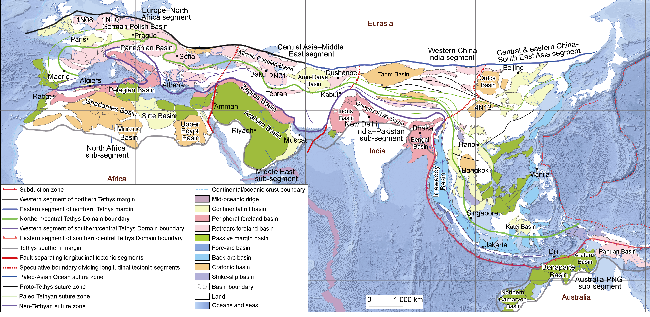
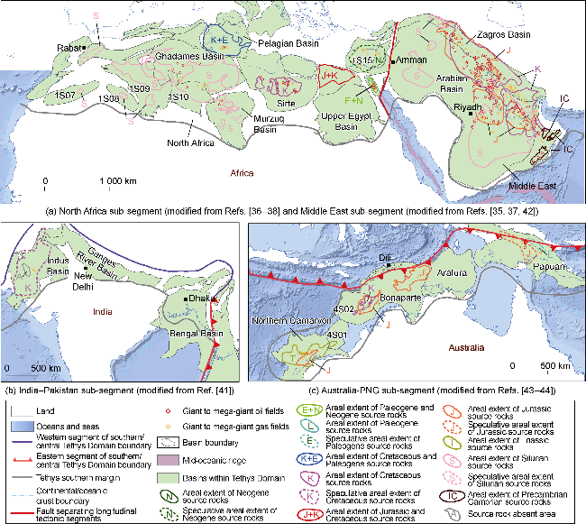
Fig. 2. Tectonic units and basin types in the Tethys Domain. The domain is divided latitudinally into northern, central, and southern belts, and longitudinally into four segments. The southern Tethys Domain is further sub-divided into four geological units from west to east: the North Africa, Middle East, India-Pakistan, and Australia-PNG sub-segments (Modified from Refs. [1,7-10]). 1N08: Anglo-Dutch Basin; 1N10: Northwest German Basin; 2N01: South Caspian Basin; 4N13: Sichuan Basin. |
2. Tectonic subdivision of the Tethys Domain
Klemme and Ulmishek [7] were the first to propose the concept of the “Tethys Domain” in the context of petroleum geology. The domain encompassed the Proto-Tethys suture zone in the north, the Paleo- and Neo-Tethys suture zones in the central part, and the Gondwanan continental margin in the south that had been transgressed by the Tethys Ocean. However, they did not explicitly specify the criteria for defining these boundaries.
Based on preceding efforts, this study re-delimits the spatial extent and tectonic subdivision of the Tethys Domain. During the Late Precambrian to the Paleozoic, the Paleo-Asian Ocean was located to the north of the Karakum-Tarim-North China plates (Fig. 1a). The Turkmenistan-Tianshan-Yinshan-Solonker-Jilin-Yanji suture zone [10], which marks its final closure, constitutes the eastern segment of the northern boundary of the Tethys Domain (Fig. 2). In the Early Paleozoic, the Iapetus Ocean to the west and the Tornquist Ocean to the south of Baltica were two ancient oceans that coexisted with the Proto-Tethys Ocean (Fig. 1b); the closure of these three oceans formed the Proto-Tethys suture zone (Fig. 1f) [1]. The Proto-Tethys suture zone along the southern margin of Baltica constitutes the western segment of the northern boundary of the Tethys Domain. Consequently, the northern boundary of the Tethys Domain is a tectonic boundary composed of the Proto-Tethys suture zone in the west and the Paleo-Asian suture zone in the east (Figs. 1f and 2). Unlike the northern boundary, the southern boundary is depositional, defined by the maximum extent of transgression by the Proto-, Paleo-, and Neo-Tethys Oceans into the interior of Gondwana prior to its breakup. The Tethys Domain is adjacent to the Pacific domain to the east [7]. The westward subduction of the Pacific Plate gave rise to a series of back-arc basins in East and Southeast Asia (Fig. 2). The eastern boundary of this group of basins is deemed as the eastern margin of the Tethys Domain. As previously mentioned, the Tethys Domain defined in this paper does not extend to South and North America. Therefore, the oceanic-continental crust boundary along the eastern margin of the Atlantic Ocean is taken as the western boundary of the Tethys Domain (Fig. 2).
According to suture zones and evolutionary characteristics, the Tethys Domain is divided into three tectonic subdivisions: northern Tethys Domain, central Tethys Domain and southern Tethys Domain [8]. The northern Tethys Domain lies between the Iapetus-Tornquist-Paleo-Asian suture zone and the southernmost Paleo-Tethys suture zone (Fig. 2). It comprises the micro-plates that rifted from Gondwana and accreted to Laurasia during the Paleozoic, representing the Paleozoic accretionary margin of Laurasia. These micro-plates had been cratonized by the end of the Paleozoic. In the Mesozoic, the northern Tethys Domain had evolved into a new cratonic area dominated by littoral-neritic sedimentation [18]. The central Tethys Domain is situated between the southernmost Paleo-Tethys suture zone and the southernmost Neo-Tethys suture zone-Sumatra-Java subduction zone (Figs. 1f and 2). It originated in an environment of alternating marine and continental accretion, involving oceanic troughs, ocean basins, and terranes during the Mesozoic. The intense tectonic compression during the Cenozoic gave rise to the modern-day Alps-Zagros-Himalaya fold-and-thrust belt [8,18]. The southern Tethys Domain represents the transgressed region of the northern Gondwana margin during the evolution of the Tethys Ocean, constituting the southern passive continental margin of the Paleo-Tethys and Neo-Tethys Oceans (Fig. 1). Therefore, the southern Tethys Domain was generally characterized by an extensional geotectonic setting throughout its history. In contrast, the central and northern Tethys Domains, especially the central Tethys Domain, were dominated by compressional geotectonic conditions.
There is a series of faults extending in a NNE-SSW direction within the Tethys Domain [19]. Among them, the Levantine fault, Owen-Chaman fault [20], and central thrust fault [21] divide the domain into four segments: Europe-North Africa, Central Asia-Middle East, western China-India, and central-eastern China-Southeast Asia, from west to east (Fig. 2). The Neo-Tethys suture zone is confined to the Europe-North Africa, Central Asia-Middle East, and western China-India segments. The northward subduction of the India Plate resulted in the complete extinction of the Greater India passive margin basin on its northern edge [22]. The foreland basins such as Ganges River to the south of the Neo-Tethys suture zone in the western China-India segment, contain only Cenozoic sedimentary strata, while the southern parts of the Europe-North Africa and Middle East-Central Asia segments preserve Paleozoic-Cenozoic sequences [18]. The corresponding geological units of the four segments within the southern Tethys Domain are, from west to east, the North Africa, Middle East, India-Pakistan, and Australia-PNG (Papua New Guinea) sub-segments (Fig. 2). Despite their similar locations within the northern Gondwana margin, these four sub-segments went through different processes of tectono-sedimentary evolution, leading to the variations in geological elements of petroleum systems and differential hydrocarbon enrichment.
3. Basin classification and hydrocarbon resources in the Tethys Domain
3.1. Basin classification in the Tethys Domain
A total of 178 sedimentary basins have been identified in the Tethys Domain, including 44 in the southern Tethys Domain, 46 in the central Tethys Domain, and 88 in the northern Tethys Domain. From the Late Paleozoic to Cretaceous, the southern Tethys Domain was located at the southern passive continental margin of the Paleo- Tethys and Neo-Tethys Oceans, predominantly with extensional basins corresponding to the embryonic, juvenile, and mature stages of the Wilson cycle. From the Late Cretaceous to the Neogene, compressional basins associated with the decline, residual, and extinction stages of the cycle began to form owing to the closure of the Neo- Tethys Ocean. Based on the classification schemes proposed by Mann et al. [23], Jia et al. [24], and Dou and Wen [25], this paper categorizes the sedimentary basins in the Tethys Domain into 7 major types: cratonic, continental rift, passive margin, strike-slip, fore-arc, back-arc and foreland basins. Back-arc basins are further divided into two subtypes: back-arc rift and back-arc depression basins; foreland basins are divided into two subtypes: peripheral foreland and retroarc foreland basins [25].
Controlled by divergent plate boundaries, the southern Tethys Domain features an extensional tectonic setting. Cratonic, continental rift, and passive margin basins dominate in the central and southern regions, whereas foreland basins prevail in the northern region adjacent to the Neo-Tethys suture zone. Among these, the Papuan Basin is a retroarc foreland basin, while the others are peripheral foreland basins (Fig. 2). The sedimentary basins in the southern Tethys Domain are situated on Gondwana, which provides an extensive basement. Consequently, the southern Tethys Domain hosts the largest basins, with the exceptions of several foreland and continental rift basins. Among the 44 sedimentary basins in the southern Tethys Domain, the median and mean areas are 20.61×10⁴ and 31.11×10⁴ km2, respectively.
The central Tethys Domain was spliced by a number of micro-plates (e.g. Carolinia, Alps, and Turkey), oceanic troughs, and ocean basins (Fig. 1c, 1d). As the Neo-Tethys Ocean closed, these micro-plates were finally accreted to the southern margin of Laurasia. Among them, Europe-Central Asia-western China, which situated at a convergent plate margin as a whole, primarily developed Mesozoic-Cenozoic retroarc foreland basins owing to intense tectonic compression. In contrast, Southeast Asia, which was in a back-arc extensional setting caused by the northeastward subduction of the Indian Ocean Plate, predominantly developed Cenozoic back-arc rift basins (Fig. 2). Compared with Gondwana in the southern Tethys Domain and the Tarim and North China Plates in the northern Tethys Domain, the micro-plates functioning as the basement in the central Tethys Domain are considerably small in size, leading to the occurrence of medium- to small-sized Mesozoic-Cenozoic sedimentary basins. Among the 46 basins in the central Tethys Domain, the median and mean areas are 5.74×10⁴ and 9.08×10⁴ km2, respectively.
The northern Tethys Domain comprises the Karakum, Tarim and North China Plates (Fig. 1a); the South China, Indochina, and Qinling Plates/micro-plates, which rifted from Gondwana and accreted to Laurasia (Fig. 1b); and accretionary terranes formed during the Caledonian and Hercynian orogenies. Basin evolution in the central-eastern China-Southeast Asia segment within the northern Tethys Domain is closely related to the westward subduction of the Pacific Plate and the opening of the South China Sea, leading to the occurrence of Cenozoic back-arc, continental rift and passive margin basins. In other areas of the northern Tethys Domain, sedimentary basins are filled with sediments of different ages due to their distinct geologic settings. The Tarim, Ordos and Sichuan basins, characterized by complete multi-cycle depositional histories, are classified as cratonic basins with sedimentary sequences spanning from the Precambrian to the Neogene. The Anglo-Dutch and Northwest German basins in Europe, developing on the Caledonian folded basement, are classified as Late Paleozoic-Cenozoic retroarc foreland basins. The Middle Caspian, South Caspian, and Amu-Darya Basins, which situated on the Hercynian folded basement in Central Asia, are Mesozoic-Cenozoic basins. The sedimentary basins in these areas are predominantly retroarc foreland and back-arc rift basins (Fig. 2). Among the 88 basins in the northern Tethys Domain, the median and mean areas are 10.12×10⁴ and 12.50×10⁴ km2, respectively.
3.2. Hydrocarbon resources in the Tethys Domain
By the end of June 2024, a total of 14 840 conventional oil and gas (including tight gas) fields had been discovered in 145 basins within the Tethys Domain, with 122 shale oil and gas fields (including tight oil fields) additionally identified in 10 of these basins. The reserves of conventional and shale oil and gas amounted to 3 545.97× 10⁸ and 46.29×10⁸ toe, respectively [11-12,26], with a total of 3 592.26×10⁸ toe (Table 1), accounting for 48.8% of the global total 2P reserves of conventional and shale oil and gas. Based on the assessments of oil and gas resource worldwide [27-28] and in China [29-30] issued by China National Petroleum Corporation, this study estimates the undiscovered recoverable resources of conventional oil and gas coming to 1 348.33×10⁸ toe within the Tethys Domain, accounting for 38.9% of the global total undiscovered recoverable resources of conventional oil and gas.
Table 1. Discovered oil and gas fields and 2P reserves in the Tethys Domain (compiled from Refs. [11-12,26]; data as of June 2024) |
| Region | Hydrocarbon type | Number of fields | 2P reserves | |||
|---|---|---|---|---|---|---|
| Oil/108 t | Gas/1012 m3 | Condensate oil/108 t | Oil equivalent/108 t | |||
| Northern Tethys Domain | Conventional | 6 621 | 187.56 | 51.99 | 18.6 | 623.67 |
| Shale | 96 | 7.60 | 1.79 | 0.13 | 22.09 | |
| Subtotal | 6 717 | 195.16 | 53.78 | 18.73 | 645.76 | |
| Central Tethys Domain | Conventional | 2 808 | 43.29 | 6.76 | 4.06 | 101.63 |
| Shale | 0 | 0 | 0 | 0 | 0 | |
| Subtotal | 2 808 | 43.29 | 6.76 | 4.06 | 101.63 | |
| Southern Tethys Domain | Conventional | 5 411 | 1 504.76 | 146.62 | 138.55 | 2 820.67 |
| Shale | 26 | 1.79 | 1.75 | 8.35 | 24.2 | |
| Subtotal | 5 437 | 1 506.55 | 148.38 | 146.90 | 2 844.87 | |
| Tethys | Conventional | 14 840 | 1 735.62 | 205.38 | 161.22 | 3 545.97 |
| Shale | 122 | 9.39 | 3.54 | 8.48 | 46.29 | |
| Total | 14 962 | 1745.01 | 208.92 | 169.70 | 3 592.26 | |
| Global | Conventional | 31 621* | 3 777.44 | 384.97 | 241.50 | 7 110.18 |
| Shale | 243* | 71.83 | 21.49 | 8.48 | 252.83 | |
| Total | 31 864 | 3 849.27 | 406.46 | 249.98 | 7 363.01 | |
Note: The count (*) excludes oil and gas fields in the US and Canada, but the total reserves cover both countries. |
The size of resources is the optimal indicator for characterizing the level of hydrocarbon enrichment in a petroliferous basin. However, given that exploration in many basins within the Tethys Domain has reached a medium to high degree, with a 2P reserves-to-resources ratio as high as 72.5% in the domain and even 79.2% in the southern Tethys Domain for conventional oil and gas, 2P reserves may be taken as a reliable alternative. As per this new criterion, this paper classifies the sedimentary basins within the Tethys Domain into 5 categories: tier-I hydrocarbon-rich basins with reserves exceeding 13.6×10⁸ toe (100×108 barrels of oil equivalent (boe)), tier-II basins with reserves from 6.8×10⁸ toe to 13.6×10⁸ toe (50×108-100×108 boe), tier-III basins with reserves from 1.4×10⁸ toe to 6.8×10⁸ toe (10×108-50×108 boe), tier-IV basins with reserves less than 1.4×10⁸ toe (10×108 boe), and basins with no documented hydrocarbon discoveries.
Taking each individual basin as the statistical unit, this study classifies a basin as gas-rich if its gas reserves exceed 50% of the total hydrocarbon reserves; otherwise, it is classified as oil-rich. Statistics reveal that the Tethys Domain contains 24 tier-I, 18 tier-II, 28 tier-III, and 75 tier-IV basins (Fig. 3). The reserves in tier-I basins are comparable to those of tier-one super basins [31], accounting for 91.9% of the Tethys's total reserves. 10 tier-I basins occur in the southern Tethys Domain, namely the Arabian (accounting for 56.3% of the Tethys's total reserves), Zagros (12.0%), Ghadames (2.0%), Sirte, Oman, Northern Carnarvon, Illizi, Gulf of Suez, Nile Delta, and Bonaparte Basins (Figs. 3 and 4a). Compared with the global super basins defined by Fryklund and Stark [31], this study includes four additional basins: the Ghadames and Nile Delta Basins previously categorized as tier-two super basins as well as the Gulf of Suez and Bonaparte Basins originally not classified as super basins. 13 tier-I basins are located in the northern Tethys Domain, yet they host only 15.1% of the Tethys's total reserves. The five richest basins in this region are the Amu-Darya (3.9%), South Caspian (1.8%), Bohai Bay, Northwest German, and Ordos Basins in sequence. The central Tethys Domain contributes only one basin: Central Sumatra (0.6%), to this category.
Fig. 3. Petroliferous basins with varying levels of hydrocarbon richness in the Tethys Domain (Reserve data from Ref. [11]). 1N10: Northwest German Basin; 1S10: Illizi Basin; 1S13: West Desert Basin; 1S15: Nile Delta Basin; 1S17: Levantine Basin; 1S19: Gulf of Suez Basin; 2N01: South Caspian Basin; 2S01: Oman Basin; 3S02: Potwar Basin; 3S04: Assam Basin; 4N03: Bohai Bay Basin; 4C09: Central Sumatra Basin; 4S02: Browse Basin. |
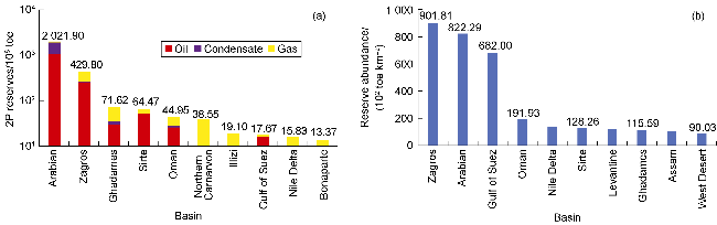
Fig. 4. Top 10 basins in the southern Tethys Domain by oil and gas reserves (a) and by reserve abundance (b) (data from Ref. [11]). |
From the perspective of tectonic subdivisions, the southern Tethys Domain contributes 79.2% of the Tethys's total reserves, followed by 18.0% and 2.8% for the northern and central Tethys Domains, respectively. By segments, Central Asia-Middle East contains 76.6% of the total reserves, followed by central-eastern China-Southeast Asia (11.4%), Europe-North Africa (10.5%), and western China-India (merely 1.5%).
4. Geologic features and distribution of oil and gas in the southern Tethys Domain
4.1. Petroleum geologic features
4.1.1. Oil and gas fields and reserves
A total of 5 411 conventional oil and gas fields have been discovered in 39 sedimentary basins within the southern Tethys Domain. Additionally, 26 shale oil and gas fields have been identified in the Arabian, Zagros, and Oman Basins. The 2P reserves of conventional and shale oil and gas are 2 820.67×10⁸ and 24.20×10⁸ toe, respectively, totaling 2 844.87×10⁸ toe (Table 2). Oil reserves account for 52.9%. The oil-dominated enrichment pattern in the southern Tethys Domain presents a sharp contrast to the gas-dominated patterns in the central and northern Tethys Domains, where oil reserves account for 42.6% and 30.2%, respectively.
Table 2. Hydrocarbon reserves in the southern Tethys Domain (compiled from Ref. [11]; data as of June 2024) |
| Sub-segment | Hydrocarbon type | Number of fields | Reserves | |||
|---|---|---|---|---|---|---|
| Oil/108 t | Gas/1012 m3 | Condensate/108 t | Oil equivalent/108 t | |||
| North Africa | Conventional | 2 580 | 121.21 | 14.27 | 13.97 | 249.79 |
| Middle East | Conventional | 1 798 | 1 372.87 | 122.36 | 117.09 | 2 472.49 |
| Shale | 26 | 1.79 | 1.75 | 8.35 | 24.20 | |
| Subtotal | 1 824 | 1 374.66 | 124.11 | 125.44 | 2 496.69 | |
| India-Pakistan | Conventional | 599 | 5.12 | 2.27 | 0.83 | 24.14 |
| Australia-PNG | Conventional | 434 | 5.56 | 7.73 | 6.66 | 74.25 |
| Total | Conventional | 5 411 | 1 504.76 | 146.62 | 138.55 | 2 820.67 |
| Shale | 26 | 1.79 | 1.75 | 8.35 | 24.20 | |
| Grand total | 5 437 | 1 506.55 | 148.38 | 146.9 | 2 844.87 | |
According to the classification by field size [32-33], 0.68× 10⁸-6.82×10⁸ t (5×10⁸-50×108 boe) for giant fields, 6.82× 10⁸-68.21×10⁸ t (50×108-500×108 boe) for super-giant fields, and over 68.21×10⁸ t (500×108 boe) for mega-giant fields), the southern Tethys Domain hosts 3 mega-giant oil fields and 2 mega-giant gas fields with oil and gas reserves accounting for 27.8% of the total reserves in the southern Tethys Domain. Additional 40 super-giant oil fields and 8 super-giant gas fields contribute 28.3% of the total reserves. Furthermore, 164 giant oil fields and 120 giant gas fields contribute 15.9% of the total reserves. In total, 337 giant to mega-giant fields have been discovered in the southern Tethys Domain.
The regional distribution of giant to mega-giant fields in the southern Tethys Domain is highly uneven. The Middle East sub-segment is the predominant enriched zone with 248 such fields, accounting for 73.6% of the region's total. More notably, this sub-segment includes all 5 mega-giant fields and 46 of the 48 super-giant fields, further highlighting its pivotal status (Table 3). The North Africa sub-segment hosts 58 such fields, including 2 super-giant fields and 56 giant fields. The Australia-PNG and India-Pakistan sub-segments contain 27 and 6 giant fields, respectively (Table 3). This distribution pattern of giant to mega-giant fields has resulted in the high concentration of hydrocarbon resources in the Middle East sub-segment, where the reserves amount to 2 496.69×10⁸ toe (Table 2), as 87.8% of the region's total reserves (Fig. 5). Despite the largest number of discovered fields (2 580), the North Africa sub-segment contains a limited number of giant and super-giant fields, contributing only 8.8% to the region's total reserves. The Australia-PNG and India-Pakistan sub-segments, with even fewer giant fields, hold 2.6% and 0.8% of the region's total reserves, respectively. In terms of the oil-gas reserves proportion, oil accounts for 55.2% of the total reserves in the Middle East sub-segment and 48.4% in the North Africa sub-segment. The India-Pakistan and Australia-PNG sub-segments are gas-rich areas; the gas-reserves proportion is 75.4% for the former and as high as 83.5% for the latter (Fig. 5).
Table 3. Giant, super-giant, and mega-giant hydrocarbon fields in the southern Tethys Domain (compiled from Ref. [11]) |
| Type | North Africa | Middle East | India-Pakistan | Australia-PNG | ||||
|---|---|---|---|---|---|---|---|---|
| Number of oil fields | Number of gas fields | Number of oil fields | Number of gas fields | Number of oil fields | Number of gas fields | Number of oil fields | Number of gas fields | |
| Giant field | 34 | 22 | 129 | 68 | 1 | 5 | 1 | 26 |
| Super-giant field | 1 | 1 | 39 | 7 | 0 | 0 | 0 | 0 |
| Mega-giant field | 0 | 0 | 3 | 2 | 0 | 0 | 0 | 0 |
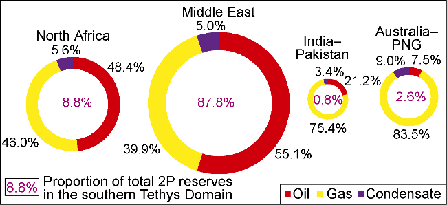
Fig. 5. Regional distribution of hydrocarbon reserves among sub-segments of the southern Tethys Domain (data from Ref. [11]). |
4.1.2. Oil and gas reservoir types
Conventional oil and gas reserves account for 99.1% of the total 2P reserves in the southern Tethys Domain, while shale oil and gas contribute merely 0.9%. A total of 8 814 conventional oil and gas reservoirs have been discovered in structural, stratigraphic/lithologic and composite traps. Trap types vary greatly among the sub-segments. Structural traps dominate in the Middle East, India-Pakistan, and Australia-PNG sub-segments, with oil and gas reserves accounting for 94.0%, 85.8%, and 61.3% of the sub-segment's total reserves, respectively (Fig. 6a). The North Africa sub-segment mainly contains composite traps, including structural-stratigraphic, structural- lithologic, and structural-hydrodynamic types, with oil and gas reserves accounting for 58.3% of the sub-segment’s total reserves. The Australia-PNG sub-segment also demonstrates the significance of composite traps, which contribute 35.2% to the sub-segment's total reserves (Fig. 6a).
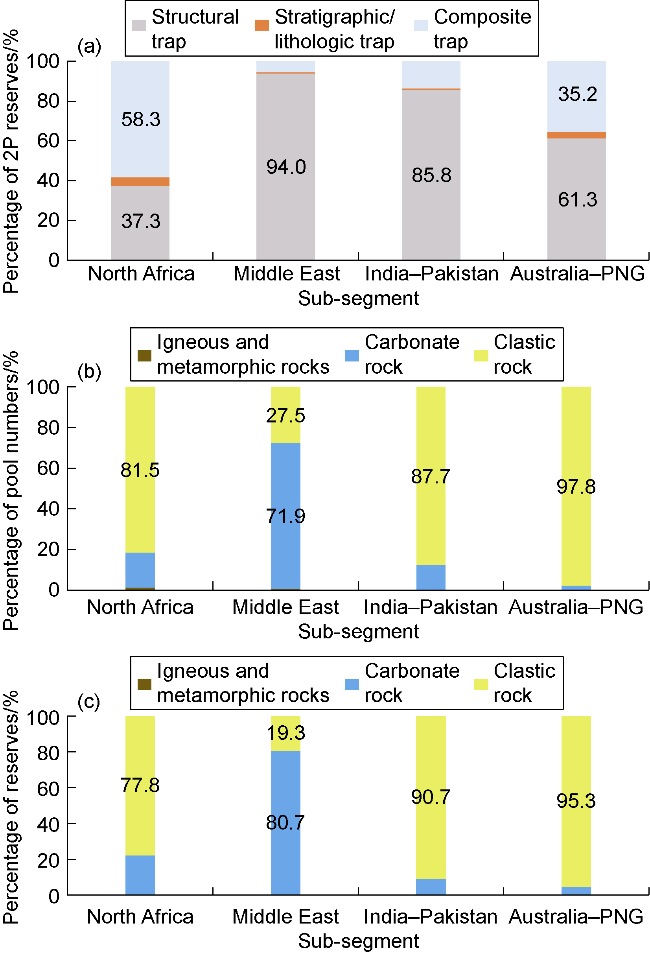
Fig. 6. Percentage of reserves of different traps (a), percentage of pool numbers (b) and percentage of reserves (c) of different reservoir lithologies by sub-segment in the southern Tethys Domain (data from Ref. [11]). |
4.1.3. Reservoir lithologies
The reservoir rocks for conventional oil and gas in the southern Tethys Domain comprise three major types: clastic (predominantly sandstones), carbonate, and crystalline rocks (crystalline magmatic and metamorphic).
Carbonate reservoirs dominate in the Middle East sub-segment, accounting for 71.9% of the number of reservoirs (Fig. 6b) and 80.7% of the 2P reserves (Fig. 6b, 6c). This demonstrates the overwhelming dominance of carbonate reservoirs over their clastic counterparts in reserve scale. Clastic reservoirs dominate in the North Africa, India-Pakistan, and Australia-PNG sub-segments, contributing 77.8%, 90.7%, and 95.3% of the total 2P reserves, respectively (Fig. 6c).
4.2. Hydrocarbon distribution
4.2.1. Areal distribution
The Arabian Basin holds the most abundant hydrocarbon 2P reserves of 2 021.90×10⁸ toe, accounting for 71.1% of the total reserves in the southern Tethys Domain. The Zagros Basin ranks second, with 2P reserves of 429.8×10⁸ toe, representing 15.1% of the total. The reserves in the two basins are significantly greater than those in the 3rd-10th ranked basins (Fig. 4a). Statistically by reserve abundance (calculated in toe), Zagros is the most enriched basin with a value of 9.02×10⁴ t/km2, closely followed by the Arabian (8.22×10⁴ t/km2) and the Gulf of Suez (6.82×10⁴ t/km2). These three basins far outstrip those hydrocarbon-rich basins ranked 4th to 10th in reserve abundance (Fig. 4b). Ranked by reserves, the Levantine and West Desert basins in the North Africa sub-segment and the Assam Basin in the India-Pakistan sub-segment occupy the 13th, 15th, and 19th positions, respectively. However, their relatively small basin sizes have resulted in higher placements of 7th, 10th, and 9th, respectively, in the reserve abundance ranking (Fig. 4b). In contrast, the Northern Carnarvon, Illizi, and Bonaparte basins, which rank 6th, 7th, and 10th in total reserves, drop to 12th, 11th, and 20th, respectively, in the reserve abundance ranking owing to their large basin scales. The overwhelming hydrocarbon richness in the Arabian Basin is attributed to the occurrence of the giant to mega-giant fields. It hosts the top 9 hydrocarbon fields in the southern Tethys Domain. The 10th largest field lies in the Zagros Basin.
Analyzed by sub-segment, the reserve abundances (calculated in toe) of the Middle East, North Africa, Australia-PNG, and India-Pakistan sub-segments are 6.82× 10⁴, 0.51×10⁴, 0.33×10⁴, and 0.13×10⁴ t/km2, respectively, with a ratio of 52:4:2.5:1. In terms of hydrocarbon reserves, the relative ratio is 87.8:8.8:2.6:0.8 for the four sub-segments. The statistical results indicate that whether evaluated by reserves or reserve abundance, the order of hydrocarbon enrichment level among the four sub-segments remains unchanged, with the Middle East sub-segment far ahead in both aspects.
4.2.2. Stratigraphic distribution by geological age
Oil and gas accumulate in multiple reservoir intervals from the Precambrian to Neogene in the southern Tethys Domain, but the dominant reservoirs vary significantly across different sub-segments. In the North Africa sub-segment, Precambrian formations are absent. Except for this missing succession, all other sedimentary sequences and Precambrian basement crystalline rocks contain oil and gas. There are four reservoir units with individual reserves accounting for more than 10% of the total reserves. They are Triassic, Neogene, Paleogene, and Cretaceous, with their respective contributions to the sub-segment's total reserves as 19.7%, 17.5%, 15.4% and 13.1% (Fig. 7a), collectively representing 65.7% of the total. In the Middle East sub-segment, oil and gas accumulate in all sedimentary sequences from the Precambrian to Neogene and Precambrian basement crystalline rocks. The four richest units, i.e. Cretaceous, Jurassic, Permian, and Triassic, respectively contribute 35.3%, 21.5%, 17.7%, and 12.0% to the sub-segment's total reserves, collectively accounting for 86.4% (Fig. 7b).
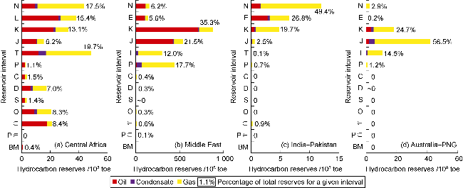
Fig. 7. Stratigraphic distribution of proved and probable reserves of different sub-segments in the southern Tethys Domain (data from Ref. [11]). N: Neogene; E: Paleogene; K: Cretaceous; J: Jurassic; T: Triassic; P: Permian; C: Carboniferous; D: Devonian; S: Silurian; O: Ordovician; ϵ: Cambrian; Pϵ : Precambrian; BM: basement. |
Compared with the North Africa and Middle East sub-segments, the India-Pakistan and Australia-PNG sub-segments exhibit several stratigraphic gaps: Ordovician-Carboniferous for the former and Precambri- an-Ordovician for the latter. Consequently, hydrocarbon enrichment in these two sub-segments is more concentrated. Oil and gas in the India-Pakistan sub-segment mainly occur in the Neogene, Paleogene and Cretaceous. These systems respectively contain 49.4%, 26.8%, and 19.7% of the total reserves (Fig. 7c), collectively constituting 95.8% of the total. Dominant reservoir units in the Australia-PNG sub-segment: Jurassic, Cretaceous, and Triassic, hold 56.5%, 24.7%, and 14.5% of the total reserves, respectively (Fig. 7d), with a combined proportion of 95.7%.
5. Dominant controls on differential hydrocarbon enrichment in the southern Tethys Domain
Zhu et al. [13] explored the key factors controlling hydrocarbon enrichment in the Tethys Domain from a novel perspective of lithosphere-hydrosphere-atmosphere-biosphere interactions. They proposed that this enrichment is primarily governed by the slow drift of continental blocks and their long-term residence in favorable climatic zones. However, their macro-scale "one-way train loading" dynamic model has difficulties in adequately addressing the significant disparities in hydrocarbon enrichment among adjacent basins within the same sub-segment (Fig. 3). The enrichment heterogeneity in the study area is dominated not only by macroscopic factors beyond the basin scale, but also, to a greater extent, by geologic factors at the basin and even smaller scales. Therefore, this paper intends to discuss these controls from the perspectives of basin formation, hydrocarbon generation and hydrocarbon accumulation.
5.1. Basin prototype, sedimentary successions, and subsequent basin modification controlled by Tethyan tectonic evolution
In the southern Tethys Domain, the impact of the Hercynian orogeny arising in the Carboniferous is most pronounced in the North Africa sub-segment, particularly in its western part, where intense folding and denudation occurred beneath the Hercynian unconformity. This orogenic influence is moderately expressed in the Middle East sub-segment but is absent in the India-Pakistan and Australia-PNG sub-segments [18]. The North Africa and Middle East sub-segments both experienced two-phase extensional-compressional tectonic cycles, whereas the India-Pakistan and Australia-PNG sub-segments experienced only one cycle: Precambrian-Paleogene extension followed by Neogene compression (Fig. 8). In the North Africa sub-segment, the early extension occurred from the Cambrian to Devonian, followed by a transition to the compressional phase during the Carboniferous to Permian [34]. The Middle East sub-segment experienced early compression primarily in the Early Carboniferous, shifting to a regional extensional phase from the Late Carboniferous [3,35].
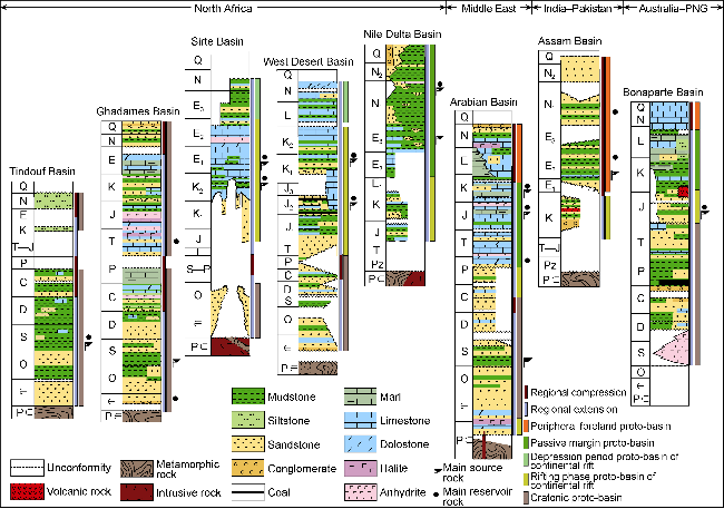
Fig. 8. Comprehensive stratigraphic columns of representative basins in the southern Tethys Domain (the base of the Triassic was used as the reference datum for stratigraphic correlation; modified from Ref. [11]). N: Neogene; N1: Miocene; N2: Pliocene; E: Paleogene; E1: Paleocene; E2: Eocene; E3: Oligocene; K: Cretaceous; J: Jurassic; T: Triassic; P: Permian; C: Carboniferous; D: Devonian; S: Silurian; O: Ordovician; ϵ: Cambrian; Pz: Paleozoic; Pϵ: Precambrian. |
Regional tectonic setting controls the types of prototype basins and their sedimentary successions. The western part of the North Africa sub-segment is dominated by Paleozoic and Mesozoic-Cenozoic cratonic prototype basins. Except for the Ghadames and Illizi basins, Mesozoic-Cenozoic sedimentary sequences are underdeveloped in this area [36]. Primary source rocks are Lower Silurian hot shales (which refer to Upper Ordovician-Lower Silurian black shales rich in graptolite fossils, characterized by high GR values and closely related to the Proto-Tethys evolution. Hot shales are distributed extensively in North Africa, the Arab region, and southern China, serving as world-class high-quality source rocks) (Fig. 9a). The Upper Triassic-Lower Jurassic evaporites constitute the regional seal. The Cambrian, Ordovician, and Triassic sandstones unconformably underlying the regional evaporite seal form the principal reservoir rocks. The eastern part of the North Africa sub-segment is dominated by Mesozoic-Cenozoic continental rift and passive margin prototype basins, with underdeveloped Paleozoic sedimentary sequences. Predominant reservoir intervals include the Cretaceous, Paleogene and Neogene. Oil and gas were mainly derived from the Upper Cretaceous as well as Paleogene and Neogene source rocks [36-38] (Fig. 9a).
Fig. 9. Distribution of giant to mega-giant fields and principal source rocks in primary petroliferous basins in the southern Tethys Domain. 1S07: Tindouf Basin; 1S08: Reggane Basin; 1S09: Timimoun/Ahnet Basin; 1S10: Illizi Basin; 1S15: Nile Delta Basin; 4S01: Roebuck Basin; 4S02: Browse Basin; 4S01: Roubuk Basin; 4S02: Browse Basin. |
The Middle East sub-segment, which experienced two-phase extensional-compressional tectonic cycles, hosts the most complete sedimentary successions (Fig. 8), particularly in the Central Arabian and Rub Al Khal Sub-basins within the southern part of the Arabian Basin, as well as the Oman Basin [20]. The early extension gave birth to Precambrian-Early Cambrian continental rift prototype basins, with overlying Cambrian-Early Carboniferous cratonic prototype basins. During the opening and closure of the Neo-Tethys Ocean from the Late Carboniferous to the Neogene, the Middle East sub-segment developed three-phase prototype basins: Late Carboniferous-Late Permian continental rift, Late Permian-Late Cretaceous passive margin, and Late Cretaceous-Neogene foreland. The latter two-phase prototype basins were mainly filled with marine carbonate rocks [35]. The relatively complete sedimentary successions provide the material basis for the development of multiple source rocks and reservoir-seal assemblages in the Middle East sub-segment. Moderate basin modification activities not only created a series of large-scale inherited structures and structural traps, but also provided a guarantee for the birth and preservation of giant to mega-giant oil and gas fields [39-40]. These factors collectively led to the high degree of hydrocarbon enrichment in this sub-segment (Fig. 5).
In the India-Pakistan and Australia-PNG sub-segments, Paleozoic sediments are underdeveloped or sparsely scattered and mainly composed of clastic rocks. They were deposited in cratonic prototype basins, which were overlain by Mesozoic-Cenozoic cratonic-continental rift-passive margin-foreland prototype basins. The completeness of this superimposed sequence varies across different basins. The Bonaparte Basin exhibits a complete superimposed sequence of prototype basins associated with the opening and closure of the Neo-Tethys Ocean, whereas the Potwar and Assam Basins only host Cretaceous continental rift and Cenozoic foreland prototype basins [41] (Fig. 8). Compared with other sub-segments, the India-Pakistan sub-segment possesses the least complete sedimentary formations. Only the larger-scale Indus and Bengal Basins qualify as tier-II gas-rich basins (Fig. 3).
Based on the basin and field data from S&P Global [11], this study investigates the statistical relationships among hydrocarbon reserves, reserve abundance, and basin types in the southern Tethys Domain. Among the 10 richest basins in the southern Tethys Domain, three are continental rift basins. Specifically, the Sirte and Gulf of Suez Basins are monotype continental rift basins. In contrast, the Oman Basin is a superimposed basin that has experienced an evolutionary process of continental rift-cratonic-passive margin-foreland prototype basins. It is classified as a continental rift basin because its primary source rocks were deposited in the Precambrian-Early Cambrian continental rift prototype basin [23] Statistically by basin type, continental rift basins exhibit the highest median reserve abundance (calculated by toe) of 1.09×10⁴ t/km2, significantly higher than that of passive margin, foreland and cratonic basins (Table 4).
Table 4. Proved and probable reserve abundance by basin type in the southern Tethys Domain (compiled from Ref. [11] up dated by June 2024) |
| Basin type | Number of basins | Reserves (toe)/108 t | Reserves proportion/% | Area/104 km2 | Reserve abundance/(104 t·km−2) | |||
|---|---|---|---|---|---|---|---|---|
| Min | Med | Max | Avg | |||||
| Rift | 6 | 149.1 | 5.2 | 115.1 | 0.001 | 1.09 | 6.82 | 0.013 |
| Passive margin | 14 | 2 120.5 | 74.5 | 500.3 | 0 | 0.42 | 8.22 | 0.042 |
| Foreland | 17 | 473.8 | 16.7 | 338.3 | 0 | 0.12 | 9.02 | 0.014 |
| Cratonic | 7 | 101.6 | 3.6 | 278.7 | 0 | 0.11 | 1.16 | 0.004 |
As per the analysis of the correlation between prototype basin superimposition patterns and hydrocarbon enrichment, three categories, i.e. cratonic-continental rift-passive margin, cratonic-continental rift-passive margin-foreland, and monocyclic continental rift basins, are most conducive to hydrocarbon accumulation and enrichment. Four of the top ten basins with the highest reserve abundance in the southern Tethys Domain, i.e. Arabian, Nile Delta, Oman, and Levantine, as shown in Fig. 4b, are cratonic-continental rift-passive margin basins. Furthermore, several tier-one super basins beyond the study area, like Gabon, Campos, and Santos Basins, on both sides of the Atlantic Ocean, also belong to this basin type. The Zagros Basin, with the highest reserve abundance, and the Assam Basin ranked 9th are classified as cratonic-continental rift-passive margin-foreland basins. This category also includes the tier-one super basins outside the study area, including Western Canada, Eastern Venezuelan, Permian, and Alaska North Slope Basins. The Gulf of Suez (ranked 3rd in reserve abundance), Sirte (6th), and West Desert (10th) Basins are monocyclic continental rift basins. This classification also applies to the tie-one super basins outside the study area, including West Siberian, North Sea, Bohai Bay and Songliao. The above analysis demonstrates that monocyclic continental rift basins and superimposed basins with an evolution phase for the prototype of continental rift are most conducive to hydrocarbon accumulation and enrichment.
5.2. Spatiotemporal distribution of high-quality source rocks controlled by prototype basin types and superimposition patterns
Source rocks in the southern Tethys Domain mainly reside in the depositional sags within cratonic, passive margin, and continental rift basins that formed in an extensional tectonic setting. Foreland basins also host organic-rich source rocks, most of which are still immature and fail to become effective due to their shallow burial depth. Within the Sahara craton of the western North Africa sub-segment, the cratonic basins contain only one set of primary source rocks: Lower Silurian hot shales, which are distributed mainly in the Ghadames, Illizi, and Timimoun/Ahnet Basins and sporadically in other basins such as Murzuq, Tindouf and Reggane (Fig. 9a). Organic matter originates from marine planktons dominated by algae, with primarily Type-II kerogens [45]. The source rocks have entered the gas window in most areas owing to large burial depth [46], resulting in a predominance of natural gas in generated hydrocarbons. The 1st and 3rd richest basins in the North Africa sub-segment, i.e. Ghadames and Illizi, are both classified as tier-I gas-rich basins. The petroliferous basins in the eastern North Africa sub-segment are characterized by Mesozoic-Cenozoic petroleum systems. Each basin hosts only one or two Mesozoic-Cenozoic source rock intervals with closely similar geologic ages (Fig. 9a). In the tier-I oil-rich Sirte Basin, the primary source rocks are Upper Cretaceous and Paleocene marine shales deposited during the evolution phase of its continental rift prototype basin [47]. In the tier-I gas-rich Nile Delta Basin, the counterparts are Oligocene and Miocene marine shales deposited in its passive margin prototype basin [48]. Regionally, Lower Silurian and Mesozoic-Cenozoic source rocks in the North Africa sub-segment occur in parallel, with no vertical superposition.
The Arabian Basin in the Middle East sub-segment hosts three sets of primary source rocks: Lower Silurian, Middle-Upper Jurassic, and Lower Cretaceous-lower Upper Cretaceous. The geologic and geochemical features of the Lower Silurian hot shales are similar to those in North Africa [45]. The Jurassic and Cretaceous source rocks were deposited in passive margin prototype basins, with the passive continental margin shelf of approximately 1 000 km wide at that time. The extensive shelf led to restricted water circulation and the consequent stagnant reducing environment of the intra-shelf sedimentary depressions [35]. The stagnant environment as well as the long-term low-latitude climatic and ocean current conditions in the Mesozoic facilitated the deposition and preservation of organic-rich argillaceous limestones, marls and mudstones/shales [13]. As shown in Fig. 9a, the three sets of primary source rocks in the Arabian Basin are characterized by extensive areal distribution, covering several hundred thousand square kilometers, and by vertical superimposition. Pepper et al. [49] simulated the hydrocarbon expulsion from the Upper Jurassic source kitchen in the Saudi Arabian sector of the Arabian Basin. Based on the source rocks' average thickness of 45 m and depositional area of approximately 34×104 km2, the intensity of hydrocarbon expulsion was simulated to be 5×10⁶ toe/km2, and the total expelled hydrocarbons were estimated at approximately 17 000×108 toe accordingly. The Middle East sub-segment contains several primary source kitchens of comparable or even larger scale (Fig. 9a). Accordingly, it may be inferred that the amount of hydrocarbons expulsed from these kitchens would be much higher than 17 000×108 toe. The massive hydrocarbon expulsion is a key control on the exceptional hydrocarbon endowment in the Middle East sub-segment, particularly in the Arabian Basin.
Individual basins in the India-Pakistan and Australia-PNG sub-segments typically contain only one or two sets of primary source rocks with closely similar geologic ages. Furthermore, the scale of these source rocks is considerably smaller than that in the Middle East sub-segment (Fig. 9b, 9c). The Northern Carnarvon Basin hosts Upper Triassic and Jurassic source rocks. The Jurassic source rocks have an average thickness of 600 m and a depositional area of approximately 3.6×10⁴ km2, with Type-III and Type-II kerogens [50]. According to Klemme's estimation [50], these Jurassic source rocks have expelled approximately 4 460× 108 toe of hydrocarbons. Although this amount is much smaller than that of the Arabian Basin, it is still substantial and provides a material basis for hydrocarbon enrichment. Therefore, this basin is classified as a tier-I gas-rich basin ranking 6th in hydrocarbon enrichment in the southern Tethys Domain.
5.3. Stratigraphically differentiated hydrocarbon enrichment controlled by three major reservoir-seal assemblages
The Middle East sub-segment hosts three regionally extensive evaporite capping beds. These evaporites and conformably underlying grainstone, dolomite, or fractured carbonate reservoirs, with medium to high porosity and permeability, constitute high-quality reservoir-seal assemblages. According to the data from S&P Global [11], carbonate reservoirs from the Upper Permian-Lower Triassic Khuff Formation are composed of grainstones and dolomites, with porosity ranging from 4% to 33% and averaging 15.7%. Serving as the reservoir interval for 88 oil and gas fields, including mega-giant North and South Pars gas fields, the Khuff Formation holds hydrocarbon reserves of up to 758.60×10⁸ toe, accounting for 30.7% of the total conventional oil and gas reserves in the Middle East sub-segment. Reservoir rocks of the Upper Jurassic Arab Formation comprise packstones, grainstones and dolomites, with porosity ranging from 9% to 36% and averaging 20.5%. Arab reservoirs involve 132 fields, including super-giant Ghawar and super-giant Rumaila oil fields, with hydrocarbon reserves reaching 377.66×10⁸ toe, accounting for 15.3% of the total reserves. The Oligocene-Miocene Asmari Formation, composed of fractured limestones and sandstones, owes its natural fractures to the Alpine orogeny. The existence of the fracture network significantly enhances the reservoir properties of limestones. Distributing in 131 oil and gas fields, Asmari reservoirs hold hydrocarbon reserves of 254.79×10⁸ toe, accounting for 10.3% of the total.
The North Africa sub-segment also hosts evaporite capping beds. In the Ghadames and northern Illizi Basins, Upper Triassic-Lower Jurassic evaporites act as effective seals to preserve hydrocarbon accumulations in Paleozoic-Triassic sandstone reservoirs. The reservoir-seal assemblage consisting of the evaporites and underlying sandstones constitutes one of the major controlling factors for Ghadames and Illizi being classified as tier-I gas-rich basins [51]. In the tier-I oil-rich Sirte Basin, Eocene evaporites form the semi-regional seal for Paleocene limestone reservoirs. As the most critical reservoir-seal assemblage in the basin, it hosts 38.7% of the basin's total reserves. In the northwest shelf of the Australia-PNG sub-segment, thick Lower Cretaceous shales with extensive distribution act as the regional seal to preserve more than 95% of hydrocarbon reserves. This seal represents a key factor in the formation and preservation of giant gas fields in the petroliferous basins, the northwest shelf, where Northern Carnarvon and Bonaparte are classified as tier-I gas-rich basins and Browse as tier-II gas-rich basin (Fig. 3).
5.4. Large inherited basement uplifts as the most petroleum-rich structural units
The heterogeneous nature of the Arabian Plate's basement provides the tectonic foundation for the multi-phase development of basement fractures and paleo-uplifts. Accompanied by Rodinia's breakup at the end of the Precambrian, the Najd fault system in a NW-SE trend went through strike-slip movement, giving rise to the basement paleo-uplifts, e.g. Summan, Qatar, Burgan, and Ghawar in the southern Arabian Basin, which are dominated by the derived basement faults extending in NNE-SSW and nearly north-south directions [52-53]. Owing to multi-phase evolution, ultra-large anticlinal structural traps formed on these paleo-uplifts, with the closure area reaching thousands of square kilometers. Additionally, these paleo-uplift areas have been perennially positioned along hydrocarbon migration pathways and thus represent key geologic units hosting giant to mega-giant fields. The oil and gas fields discovered on the three major basement paleo-uplifts (Qatar, Ghawar, and Burgan) accumulate 22.1%, 8.2%, and 4.3%, respectively, of the total reserves in the southern Tethys Domain.
The Hassi R'mel gas field and the Hassi Messaoud oil field within the Ghadames Basin are the only two super-giants in the North Africa sub-segment. These fields reside on the paleo-uplifts of the same name and accumulate 13.6% and 12.1%, respectively, of the sub-segment's total reserves. This makes Ghadames the richest basin in the sub-segment and the 3rd largest hydrocarbon-rich basin in the southern Tethys Domain. Compared with the Middle East and North Africa sub-segments, the petroliferous basins in the India-Pakistan and Australia-PNG sub-segments lack long-lived inherited basement paleo-uplifts. This absence constitutes one of the key factors that contribute to their relatively low hydrocarbon enrichment.
6. Conclusions
The Tethys Domain is the world's richest petroliferous region, with total 2P reserves of 3 592.26×10⁸ toe, accounting for 48.8% of the global total 2P reserves. However, hydrocarbon distribution within the domain is highly uneven. The southern Tethys Domain hosts 79.2% of the entire Tethys Domain's reserves, despite its area proportion of 31.6%. Furthermore, hydrocarbons in the southern Tethys Domain intensely concentrate in the Middle East sub-segment, which holds 87.8% of the region's total reserves. This is followed by the North Africa (8.8%), Australia-PNG (2.6%), and India-Pakistan (0.8%) sub-segments.
Tethys tectonic evolution governs basin formation and modification. Variations in tectonic-sedimentary evolution across the various sub-segments of the southern Tethys Domain give rise to distinct types and superimposition patterns of prototype basins, which in turn control the spatiotemporal distribution of source rocks, reservoir-seal assemblages and large-scale traps. The superimposition patterns of prototype basins, the scale and distribution of source rocks, the effectiveness of reservoir-seal assemblages, and the occurrence of inherited basement paleo-uplifts are the key controls on the differential hydrocarbon enrichment in the southern Tethys Domain. The spatiotemporal distribution of oil and gas is controlled by source rocks and seals, whereas the degree of hydrocarbon enrichment is determined by reservoir-seal assemblages and large-scale structural traps.
Moderately deformed monotype continental rift basins, cratonic-continental rift-passive margin basins, and cratonic-continental rift-passive margin-foreland basins promote the formation of high-quality source rocks, large-scale reservoir-seal assemblages, and extensive structural and composite traps. These basin types are particularly favorable for hydrocarbon accumulation, enrichment, and preservation.
The Middle East sub-segment hosts three vertically superimposed, large-scale, high-quality source rock intervals, which ensure its status as a supersized hydrocarbon-enriched region. Three extensive high-quality reservoir-seal assemblages, composed of carbonate reservoirs and evaporite seals, are essential for hydrocarbon accumulation, preservation and enrichment. Long-lived inherited basement paleo-uplifts dominate the formation of ultra-large traps, with Qatar, Ghawar, and Burgan representing structural units of exceptionally enriched hydrocarbons.