

Introduction
Compared with the plate-boundary strike-slip faults that generally slip hundreds of kilometers, strike-slip faults within cratonic basins generally have a slip distance of no more than 2 km, so they are termed intraplate strike-slip faults with small displacement [1-2]. These faults play a crucial role in the process of hydrocarbon accumulation. They contribute to the development of fault-karst reservoirs and serve as significant pathways for hydrocarbon migration [3-5].
Owing to the great significance of strike-slip faults for oil and gas exploration, extensive investigation has been conducted in the non-foreland area of the Tarim Basin, and research progress has been achieved in damage zone structure, mechanical mechanism, reservoir-controlling effect, and hydrocarbon accumulation-controlling effect. (1) The structure of the strike-slip faults. The strike-slip faults exhibit a "dual structure" composed of a kernel and a broken zone, which is layered vertically (highly steep and linear in the Cambrian-Lower Ordovician, semi-flower-like in the Middle-Lower Ordovician, and echelon- flower-like in the Middle-Upper Ordovician), and segmented laterally (including compression-torsion, tension-torsion, and translation). Meanwhile, numerous echelon faults are associated with this system [6-9]. (2) The genesis of the strike-slip faults. The large-scale strike-slip fault systems were developed under the action of southwestward, southeastward, and northward compressive stresses caused by the closure of the Tethys Ocean during the Middle Caledonian period, and experienced multi-stage reactivation during the Late Caledonian, Early Hercynian, Middle-Late Hercynian, and post-Hercynian periods (Indosinian, Yanshanian, and Himalayan periods) [10-12]. (3) Reservoir-controlling effect. The reservoir space (pores, vugs, and fractures) is the main product of fracturing and dissolution induced by strike-slip fault activities. More pores, vugs, and fractures developed in the area closer to strike- slip faults, reaching the conclusion that the tension-torsion segment has the best reservoir-controlling effect. On this basis, a "facies-fault-dissolution" three-factor reservoir-controlling model was established [13-15]. (4) Hydrocarbon accumulation-controlling effect. Source rock-connected strike-slip faults that experienced multi-stage activities are recognized as an effective controlling factor for hydrocarbon accumulation. Oil and gas reservoirs are distributed in a banded pattern along the strike-slip faults, and the NNE-trending strike-slip faults are dominant in controlling hydrocarbon accumulation. Accordingly, a "source rock-fault-reservoir-caprock" four-factor hydrocarbon accumulation-controlling model has been proposed [16-18]. However, the above understandings are generally based on qualitative research. The lack of geochronological studies on the matching relationship between strike-slip fault activities and the stages of hydrocarbon generation, reservoir formation, and hydrocarbon accumulation restricts the understanding of hydrocarbon accumulation stages and mechanisms, as well as the evaluation of the strike-slip fault-controlled hydrocarbon accumulation and the selection of favorable zones. The new dating and thermometry technologies developed in recent years are applicable for geochronological study on the matching relationship mentioned above [19-21].
In this study, laser ablation U-Pb isotope dating and clumped isotope (Δ47) thermometry are applied to determine the isotopic ages and temperatures of carbonates and quartz filling in fractures, fractured breccias, dissolution pores and vugs, as well as hydrocarbon inclusions. The strike-slip fault activities and their temporal correlation with the stages of hydrocarbon generation, reservoir formation, and hydrocarbon accumulation are investigated from dynamic and geochronological perspectives to reveal the hydrocarbon accumulation mechanism. The findings provide a basis for the evaluation of effective strike-slip faults and the selection of hydrocarbon enrichment zones in the non-foreland area, and establish a geochronological method for the evaluation of reservoir formation and hydrocarbon accumulation under the control of strike-slip faults.
1. Geologic setting
The Tarim Basin is a large (560 000 km2) superimposed basin, composed of peripheral Meso-Cenozoic foreland basins, Paleo-Mesozoic cratonic basins, and Proterozoic rift basins. It is divided into 9 structural units: the Kuqa Depression, Northern Depression, Southwest Depression, Southeast Depression, Tanggu Sag, Bachu Uplift, Tadong Uplift, Tazhong Uplift, and Tabei Uplift [22-26] (Fig. 1a). Above the cratonic crystalline basement, the Nanhua-Cainozoic sediments over 10 000 m thick formed into 4 structural layers after multiple-stage tectono-sedimentary evolutions, including the Nanhua-Sinian rift basin, Cambrian-Ordovician cratonic marine carbonate platform, Silurian-Permian cratonic marine-continental transitional carbonate-siliciclastic depression basin, and Meso-Cenozoic continental siliciclastic foreland basin [22-24]. The Upper Sinian Qigebulak Formation to the Lower Ordovician Penglaiba Formation are dominated by dolomites, the Middle Cambrian contains evaporite rocks, and the Lower Cambrian Yuertusi Formation is characterized by mudstone which is the main source rock in the non-foreland area. The Middle-Lower Ordovician Yingshan Formation and the Upper Ordovician Lianglitage Formation are mainly composed of limestone, with interbedded dolomite in the lower member of the Yingshan Formation. The mudstone of the Upper Ordovician Sangtamu Formation constitutes the regional caprock of the non-foreland area [26] (Fig. 1c).
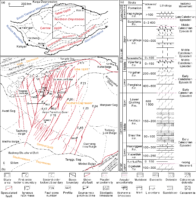
Fig. 1. Structural division of the Tarim Basin and distribution of strike-slip faults in the study area (modified from Ref. [25]). (a) Structural division of the Tarim Basin and location of the study area; (b) Distribution of strike-slip faults in the study area; (c) Stratigraphic histogram of the study area. |
The study area covers the northern slope of the Tazhong Uplift, the southern slope of the Tabei Uplift, and the transitional zone between the Awati Depression and the Manjar Depression (a part of the Northern Depression). Strike-slip faults are well developed in the study area, including 25 first-order and 55 second-order faults, predominantly trending in the NNE and NNW directions (Fig. 1b) [26]. These faults are mainly distributed within Cambrian-Ordovician carbonate rocks and are vertically divided into three structural layers (Fig. 2). Highly steep linear strike-slip faults are primarily located in the inter-salt and sub-salt structural layers of the Middle-Lower Cambrian. En echelon strike-slip faults are mainly identified in the Upper Cambrian-Lower Ordovician structural layer. Semi-flower and flower strike-slip faults are chiefly distributed within the Middle-Upper Ordovician structural layer. The majority of strike-slip faults successively developed in these three structural layers, consisting of first-order faults and their associated secondary-order and third-order faults, such as FI5, FI10, FI17, FI19, and FI20 (Fig. 1b). These faults have undergone superimposition and modification by multi-stage tectonic activities. However, some faults are confined to specific stratigraphic units: the Middle-Lower Cambrian dolomite, the Upper Cambrian-Ordovician dolomite-limestone, and the Middle-Upper Ordovician limestone, which are almost second- and third-order faults and associated lower-order fractures [27-29]. In the northern depression, there are high-quality source rocks in the Lower Cambrian Yuertusi Formation [30-31], large-scale fault-karst carbonate reservoirs in the Middle-Upper Ordovician along the strike-slip fault zones, and thick mudstone of the Sangtamu Formation is the regional caprock, which form favorable source-reservoir-caprock assemblages. The strike-slip faults that connect to the Yuertusi Formation source rocks serve as hydrocarbon migration pathways and control the accumulation of large oil fields such as Fuman, Shunbei, and Halahatang. The NNE-trending strike-slip faults are connected to source rocks better than the NNW-trending ones, giving them a dominant role in controlling hydrocarbon accumulation [29].
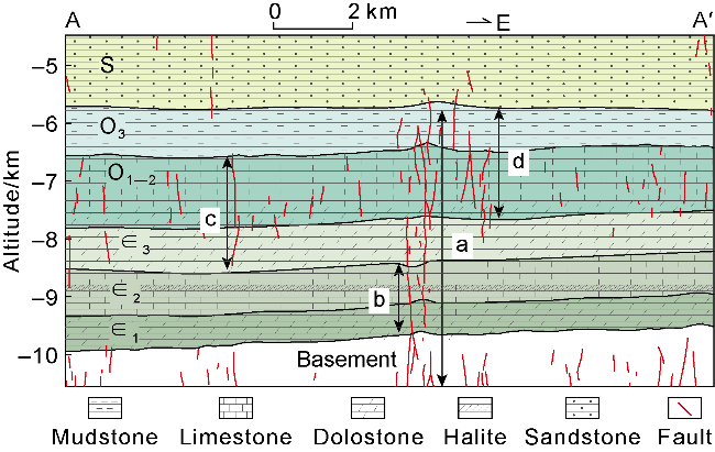
Fig. 2. Four structural patterns of strike-slip faults in the Cambrian-Ordovician in the non-foreland area of the Tarim Basin (modified from Refs. [27-29]). (a) Inherited strike-slip faults in the Cambrian-Ordovician; (b) Highly steep linear strike-slip faults in the Middle-Lower Cambrian inter-salt and sub-salt layers; (c) En echelon-flower strike-slip faults in the Upper Cambrian-Ordovician; (d) Semi-flower-flower strike-slip faults in the Middle-Upper Ordovician. ∈1, ∈2, ∈3—Lower, Middle, Upper Ordovician; O1-2—Middle, Lower Ordovician; O3—Upper Ordovician; S—Silurian. |
2. Methods
Previous studies on strike-slip faults and their reservoir-controlling and accumulation-controlling effects are almost qualitative. These studies involved reconstructing the timing of strike-slip fault activity and related controlling effects by analyzing fault characteristics and cross-cutting relationships on seismic profiles, investigating faulted strata and multi-order strike-slip fault assemblages, identifying source rock-connected faults and accumulation assemblages, and delineating fault-karst bodies [16-18]. This study employs laser ablation U-Pb isotope dating and clumped isotope thermometry on carbonate minerals and quartz [19-21] to conduct a geochronological research from quantitative and dynamic perspectives. It focuses on the stages of strike-slip fault activity, hydrocarbon generation, and reservoir formation, as well as their temporal correlations, and aims to reveal the hydrocarbon accumulation mechanisms, reconstruct the geological processes of hydrocarbon accumulation, and provide a basis for evaluating the effectiveness of strike-slip faults on hydrocarbon accumulation and for selecting hydrocarbon enrichment zones.
2.1. Laser ablation U-Pb dating and clumped isotope thermometry
The laser ablation U-Pb dating has been widely applied for precise dating of U-rich minerals (e.g., zircon, apatite) [32-33], but it is less accurate for carbonate minerals, and unfeasible for quartz, because of the following points: (1) solution U-Pb dating requires 6 to 8 parallel samples (200 mg each), but it is difficult to obtain sufficient materials in microscopic structures; (2) suitable reference material for carbonate and quartz are lacking; and (3) without high U contents, it is difficult to obtain effective 238U from carbonate and quartz whose U contents are several orders of magnitude lower than zircon. Through collaboration between the CNPC Key Laboratory of Carbonate Reservoir and the Radiogenic Isotope Laboratory at the University of Queensland, a novel laser ablation U-Pb dating technology for carbonate minerals and quartz with ultra-low U contents has been developed [20,34]. Specifically, five continuous dynode ion counters are installed on a Multi-Collector Inductively Coupled Plasma Mass Spectrometer (MC-ICP-MS) to measure the contents of 208Pb, 207Pb, 206Pb, 204Pb, 202Hg, and 238U, with a detection limit as low as 1×10⁻⁵. Reference materials of calcite, dolomite and quartz samples with ages of (209.8 ± 1.3) Ma, (248.1 ± 2.6) Ma, and (248.7 ± 7.5) Ma, respectively, have been developed. By coupling the MC-ICP-MS with a Resolution LR-S155 laser ablation system, sufficient parallel powdered samples can be obtained, enabling an upgrade from solution-based to laser-based U-Pb isotope dating with a laser beam spot diameter of less than 100 μm. Furthermore, laser scanning trace elements can create planar images of 238U content and 238U/206Pb ratio. This allows for the delineation of high 238U/206Pb ratio zones for laser dotting, significantly improving the success rate and precision of dating.
Carbonate clumped isotopes act as a novel geochemical indicator that has been widely applied over the past decade for paleotemperature reconstruction and diagenetic fluid tracing [35-36]. The clumped isotope thermometry technique addresses the challenge of determining the formation temperature of carbonate minerals that lack fluid inclusions. Its principle is that the concentration of 13C-18O bonds within carbonate minerals is influenced solely by its growth temperature and is independent of δ13C and δ18O compositions of the diagenetic fluid. Therefore, the formation temperature can be derived from the concentration of the 13C-18O bonds (measured as the concentration of the isotopologue of CO2 with mass 47). Subsequently, the δ18O value of the diagenetic fluid can be calculated using the Δ47 temperature and the measured mineral δ18O value, thereby allowing for the characterization of the diagenetic fluid. Through collaboration with the University of Miami, the CNPC Key Laboratory of Carbonate Reservoir has developed a solution-based clumped isotope thermometry technique. It involves the independent design and assembly of sample pre-treatment apparatus and the optimization of chemical procedures, successfully reducing the powder sample required from 20 mg to 10 mg. Furthermore, supporting linear regression equations and empirical transfer equations for heater and balance gas have been established for ancient marine carbonate rocks.
2.2. Determination of stages and sequences of fault activities
Burial-hydrothermal processes associated with the strike-slip fault activity inevitably cause multiple stages of diagenetic minerals that fill in the strike-slip faults of various orders, interbreccia pores, and pores and vugs induced by dissolution or physical fragmentation. These fillings are the direct records of strike-slip fault activities. Knowing the date and temperature of the minerals, it is possible to recover the absolute timings of the strike-slip fault activities, and the burial depth of the surrounding rocks during the fault activities can be converted based on the geothermal gradient. Since the formation temperatures of hydrothermal minerals such as sphalerite, galena, celestite, barite, and fluorite are generally higher than those of their surrounding rocks, there are overestimates of the burial depths of the surrounding rocks obtained by using their formation temperatures. Diagenetic minerals such as calcite, dolomite, and quartz mainly precipitate in burial-hydrothermal diagenetic media with similar temperatures to the formations. Thus, their formation temperatures can represent the burial depths of the surrounding rocks [19-21]. By identifying the multi-stage diagenetic minerals (e.g., calcite, dolomite, quartz) associated with strike-slip fault activities through outcrop, core, and thin section observations, establishing the diagenetic sequence, and measuring the ages and temperatures of these diagenetic minerals, the timing, stages and depths of strike-slip fault activities can be quantitatively reconstructed in an absolute geochronological framework.
2.3. New methods for reconstructing hydrocarbon accumulation processes
Conventional methods for reconstructing hydrocarbon accumulation processes include integrated geological analysis, fluid inclusion homogenization temperature, and Re-Os isotope dating of hydrocarbon products (crude oil, bitumen). Integrated geological analysis is a qualitative method. Aside from technical challenges, Re-Os isotope dating of hydrocarbon products is also subject to debate regarding the geological significance of the obtained ages. Consequently, fluid inclusion homogenization thermometry is currently the most prevalent method. However, it faces three major limitations. (1) The reconstruction of the structural-burial history of the target interval is crucial but inherently uncertain due to the difficulty in accurately estimating the thickness of eroded strata. (2) Although hydrocarbon inclusions remain stable and thermal cracking do not happen, the homogenization temperature measured does not directly represent the minimum temperature when the fluid inclusions are trapped, and they are significantly different from each other, so the homogenization temperature of the co-genetic brine inclusions (liquid + gaseous) is used. The coexistence of hydrocarbon inclusions with such two-phase brine inclusions within the same host mineral is scarce. (3) The trapping time estimated by converting the trapping temperature and the structural-burial history is ambiguous in cyclic and superimposed basins like the Tarim Basin. A hydrocarbon inclusion trapping temperature may correspond to multiple geological ages on the structural-burial history curve.
Under the constraint of the ages and temperatures of multi-stage diagenetic minerals, the structural-burial history of the target interval can be reconstructed more objectively. Clumped isotope thermometry is feasible to obtain the trapping temperature of hydrocarbon inclusions in the case of in the absence of cogenetic brine inclusions. Laser U-Pb dating addresses the ambiguity in multi-cyclic superimposed basins where a temperature (depth) on the structural-burial history curve corresponds to multiple ages, thereby establishing a new method for reconstructing hydrocarbon accumulation processes. The development of diagenetic minerals (e.g., calcite, dolomite, quartz) and hydrocarbon inclusions associated with strike-slip fault activities in the Cambrian-Ordovician carbonate sequences of the non-foreland area in the Tarim Basin provides a foundation for reconstructing the hydrocarbon accumulation processes.
3. Samples and results
3.1. Samples
Fractures related to strike-slip fault activities are abundant in the study area and filled with multi-stage calcite and quartz veins. In the calcite and quartz crystals, there are rich hydrocarbon and gas-liquid brine inclusions which record the history of strike-slip fault activities and the history of hydrocarbon generation and migration together with the veins. Through geochronological studies of these veins and inclusions, the history of strike-slip fault activities, the tectonic-burial history of target formations, and the history of hydrocarbon generation and accumulation, and reservoir formation, as well as their temporal matching relationships, can be reconstructed in the study area. This provides a theoretical basis for the evaluation of dominant strike-slip faults controlling hydrocarbon accumulation and fro the selection of hydrocarbon enrichment zones.
Four structural patterns of strike-slip faults have been identified in the Cambrian-Ordovician strata in the non-foreland area of the Tarim Basin [27-29] (Fig. 2). The ages of calcite and quartz fillings in the faults and their associated fractures are measured younger than the stratigraphic age, and the calcite and quartz veins of Pattern a in Fig. 2 record the most complete history of strike-slip fault activities. Therefore, (1) as many samples as possible should be collected from calcite and quartz veins in Pattern a, with those in Patterns b, c, and d as supplements; (2) multi-stage samples with clear filling sequences from the same fault or fracture should be selected as many as possible; and (3) calcite and quartz vein samples that can basically cover continuous stages should be preferentially selected to guarantee the research on the fault/fracture activity sequence and ensure a sufficient number of samples. In this study, more than 100 core samples were collected from Xiaoerbulak and other sections in Aksu, Shunbei, and Yueman areas (Fig. 3).
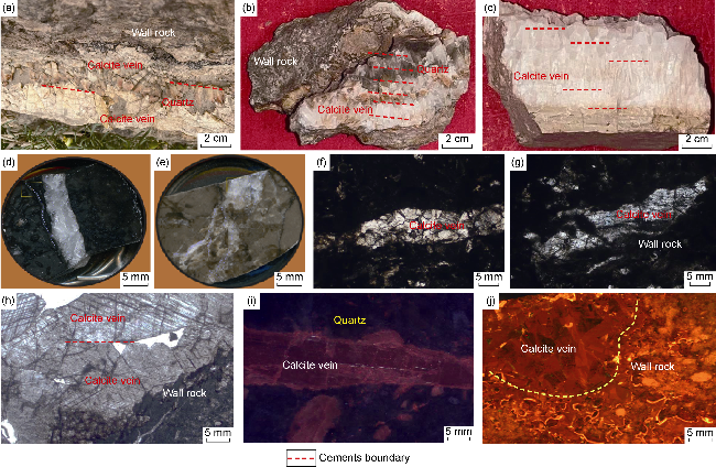
Fig. 3. Characteristics and occurrences of Cambrian-Ordovician calcite and quartz veins in the non-foreland area of the Tarim Basin. (a-b) Factures and calcite and quartz veins in Xiaoerbulak Formation dolomite, Xiaoerbulak section, Aksu; (c) fractures and calcite veins in Yingshan Formation limestone, Tianshen Grand Canyon section, Kashi; (d) fractures and calcite veins in limestone, Yijianfang Formation, Well SB16, 6 472.53 m, core photo; (e) fractures and calcite veins in limestone, Yijianfang Formation, Well YM2, 7 218.40 m, core photo; (f) fractures and calcite veins in limestone, Yijianfang Formation, Well YM5, 7 280.70 m, microscopic photo, plane polarized light; (g) fractures and calcite veins in limestone, Yijianfang Formation, Well YM8, 7 221.60 m, microscopic photo, plane polarized light; (h) fractures and calcite veins in limestone, Yijianfang Formation, Well YM8, 7 221.60 m, microscopic photo, plane polarized light; (i) fractures and dark-red calcite veins and non-luminescent quartz veins in limestone, Yijianfang Formation, Well YM20, 7 420.80 m, cathodoluminescence; (j) pores and vugs filled with orange-red calcite in limestone, Yijianfang Formation, Well YM5, 7 213.50 m, cathodoluminescence. |
3.2. Results
The laser U-Pb isotopic ages, clumped isotope temperatures, and homogenization temperatures of (gas- liquid) brine inclusions were reported by the CNPC Key Laboratory of Carbonate Reservoir. The analysis of hydrocarbon inclusions was completed at the Analytical Laboratory of Beijing Research Institute of Uranium Geology. While relevant tests were conducted on all collected samples, only 38 representative datasets were selected for detailed analysis. Based on these datasets, eight distinct filling sequences of calcite and quartz veins were identified (Table 1), including C1-Q1 (447.4-469.5 Ma), C2-Q2 (434.0-441.0 Ma), C3-Q3 (359.0-410.0 Ma), C4 (300.9-351.0 Ma), C5-Q5 (260.0-295.0 Ma), C6 (217.6-245.1 Ma), C7-Q7 (134.0-148.0 Ma), and C8 (28.9 Ma) (Fig. 4a). These eight sequences essentially represent a relatively complete filling history of calcite and quartz veins.
Table 1. Isotopic ages and temperatures of Cambrian-Ordovician calcite/quartz veins in the basin-platform area of the Tarim Basin |
| No. | Diagenetic Minerals | Outcrop/ Well | Formation | Occurrence | Age/Ma | Temperature/°C | Tectonic Epoch | |
|---|---|---|---|---|---|---|---|---|
| Δ47 | Homogenization | |||||||
| 1 | Calcite Vein (C1) | Outcrop | ∈1x | Fracture fillings | 469.5±2.8 | 60.80 | Middle Caledonian (O) | |
| 2 | Calcite Vein (C1) | Outcrop | ∈1x | Fracture fillings | 465.3±7.8 | 62.80 | ||
| 3 | Calcite Filling (C1) | Outcrop | O1-2y | Pore and vug fillings | 459.0±7.2 | 66.30 | ||
| 4 | Calcite Filling (C1) | Outcrop | O1-2y | Pore and vug fillings | 458.2±2.0 | 70.12 | ||
| 5 | Siliceous Vein (Q1) | Outcrop | ∈1x | Fracture fillings | 458.0±9.0 | 82.43 | ||
| 6 | Siliceous Vein (Q1) | Outcrop | ∈1x | Fracture fillings | 454.0±11.0 | 75.74 | 80.57 | |
| 7 | Calcite Filling (C1) | SB16 | O2yj | Pore and vug fillings | 447.4±2.9 | 78.20 | ||
| 8 | Calcite Filling (C2) | SB16 | O2yj | Pore and vug fillings | 441.0±6.7 | 83.40 | 85.11 | Late Caledonian (S) |
| 9 | Siliceous Vein (Q2) | YM20 | O2yj | Fracture fillings | 440.0±8.3 | 89.87 | ||
| 10 | Calcite Vein (C2)* | HD301 | O2yj | Fracture fillings | 439.4±7.6 | 82.37 | ||
| 11 | Calcite Vein (C2)* | HD301 | O2yj | Fracture fillings | 436.0±5.3 | 87.13 | ||
| 12 | Calcite Vein (C2)* | YM5 | O2yj | Fracture fillings | 434.0±4.9 | 95.40 | ||
| 13 | Calcite Vein (C3) | YM5 | O2yj | Fracture fillings | 410.0±4.1 | 113.75 | Early Hercynian (D) | |
| 14 | Siliceous Vein (Q3) | YM20 | O2yj | Fracture fillings | 403.0±11.0 | 117.85 | ||
| 15 | Calcite Vein (C3) | SB401 | O2yj | Fracture fillings | 373.0±2.7 | 103.17 | 110.25 | |
| 16 | Calcite Vein (C3) | HD32 | O2yj | Fracture fillings | 372.6±4.6 | 105.15 | ||
| 17 | Calcite Vein (C3) | MS2 | O2yj | Fracture fillings | 368.0±3.3 | 92.35 | ||
| 18 | Calcite Vein (C3) | YM8 | O2yj | Fracture fillings | 367.0±2.5 | 90.57 | ||
| 19 | Calcite Vein (C3) | MS2 | O2yj | Fracture fillings | 359.0±5.6 | 97.74 | ||
| 20 | Calcite Vein (C4)* | YM2 | O2yj | Fracture fillings | 351.0±4.9 | 93.04 | Middle Hercynian (C) | |
| 21 | Calcite Vein (C4)* | YM5 | O2yj | Fracture fillings | 333.9±6.6 | 98.23 | ||
| 22 | Macrocrystalline Calcite (C4) | YM8 | O2yj | Fracture fillings | 324.0±2.3 | 81.20 | ||
| 23 | Macrocrystalline Calcite (C4) | YM8 | O2yj | Fracture fillings | 313.3±4.8 | 71.40 | ||
| 24 | Macrocrystalline Calcite (C4) | SB401 | O2yj | Pore and vug fillings | 307.5±9.3 | 75.27 | ||
| 25 | Macrocrystalline Calcite (C4) | YM6 | O2yj | Pore and vug fillings | 300.9±4.8 | 79.53 | ||
| 26 | Macrocrystalline Calcite (C5) | YM6 | O2yj | Pore and vug fillings | 295.0±5.2 | 112.58 | 116.71 | Late Hercynian (P) |
| 27 | Siliceous Vein (Q5) | Outcrop | ∈1x | Fracture fillings | 292.0±13.0 | 115.89 | ||
| 28 | Calcite Vein (C5) | YM8 | O2yj | Fracture fillings | 285.5±4.3 | 110.67 | ||
| 29 | Calcite Vein (C5)* | YM5 | O2yj | Fracture fillings | 284.5±4.5 | 107.90 | ||
| 30 | Calcite Vein (C5) | YM6 | O2yj | Fracture fillings | 274.6±3.7 | 107.57 | ||
| 31 | Siliceous Vein (Q5) | Outcrop | ∈1x | Fracture fillings | 260.0±12.0 | 115.60 | ||
| 32 | Calcite Vein (C6)* | YM6 | O2yj | Fracture fillings | 245.1±3.3 | 120.40 | Indochina (T) | |
| 33 | Macrocrystalline Calcite (C6) | Outcrop | O1-2y | Pore and vug fillings | 244.0±1.3 | 123.17 | ||
| 34 | Macrocrystalline Calcite (C6) | Outcrop | O1-2y | Pore and vug fillings | 240.5±4.1 | 125.06 | ||
| 35 | Calcite Vein (C6)* | YM5 | O2yj | Fracture fillings | 217.6±8.4 | 138.40 | 143.40 | |
| 36 | Calcite Vein (C7)* | MS2 | O2yj | Fracture fillings | 148.0±1.7 | 152.12 | 157.38 | Yanshan (J—K) |
| 37 | Siliceous Vein (Q7) | YM20 | O2yj | Fracture fillings | 134.0±15.0 | 156.30 | ||
| 38 | Calcite Vein (C8) | Outcrop | O1-2y | Fracture fillings | 28.9±5.4 | 176.35 | 180.50 | Himalayan (E—Q) |
Note: Calcite veins marked with * contain hydrocarbon inclusions; the outcrop is from the Xiaorbulak Section; ∈1x—Xiaoerbulak Formation; O1-2y— Yingshan Formation; O2yj— Yijianfang Formation; O—Ordovician; S—Silurian; D—Devonian; C—Carboniferous; P—Permian; T—Triassic; J—Jurassic; K—Cretaceous; E—Paleogene; N—Neogene. |
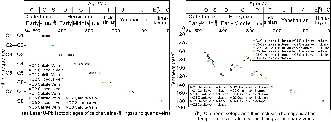
Fig. 4. Isotopic ages and temperatures of Cambrian-Ordovician calcite veins (fillings) and quartz veins in the non-foreland area of the Tarim Basin. |
They correspond to eight stages of strike-slip fault activities during the Middle Caledonian (O), Late Caledonian (S), Early Hercynian (D), Middle Hercynian (C), Late Hercynian (P), Indosinian (T), Yanshanian (J-K), and Himalayan (E-Q), respectively. This indicates that the strike-slip fault activities are successive and continuous in the non-foreland area of the Tarim Basin.
Among the 38 sets of temperature data corresponding in parallel to the dating results of these eight stages of calcite and quartz veins (Fig. 4), only clumped isotope temperatures are available when liquid-gas brine inclusions are absent, and only homogenization temperatures of liquid-gas brine inclusions are available when clumped isotope testing was not performed or yielded unsatisfactory results, the average values are used if the valid data are only a little different.
Hydrocarbon inclusions were discovered in five stages of calcite veins (C2, C4, C5, C6, C7) among the eight stages (Fig. 5), and their maturity shows a gradually increasing trend. Apart from the secondary gas inclusions in the calcite microfractures (Fig. 5a), four types of hydrocarbon inclusions were identified: (1) yellow-green crude oil inclusions, found in the C2 calcite veins (Fig. 5b, c), and aged (439.4±7.6) Ma and (434.0±4.9) Ma, respectively, (2) blue-green crude oil inclusions, found in the C4-C5 calcite veins (Fig. 5d, 5e), and aged (351.0±4.9) Ma and (284.5±4.5) Ma, respectively, (3) light blue crude oil inclusions, found in the C6 calcite veins (Fig. 5f, 5g), and aged (245.1±3.3) Ma and (217.6±8.4) Ma, respectively, (4) black primary gas inclusions, found in the C7 calcite veins (Fig. 5h, 5i), and aged (148.0±1.7) Ma. Additional black primary gas inclusions were observed in the C8 calcite veins, possibly representing the products of dry gas (with continuing burial) or uplifted hydrocarbon reservoir during the Late Yanshanian-Himalayan period. The host mineral for the hydrocarbon inclusions is predominantly calcite. The characteristics and distribution of the hydrocarbon inclusions suggest a hydrocarbon accumulation process with continuous burial of the target reservoir, continuous hydrocarbon generation and expulsion from the Yuertusi Formation source rocks, and a steady increase in maturity. The absence of hydrocarbon inclusions in the C3/Q3 calcite/quartz veins is likely resulted from the tectonic uplift and stagnant hydrocarbon generation at the end of the Silurian period.
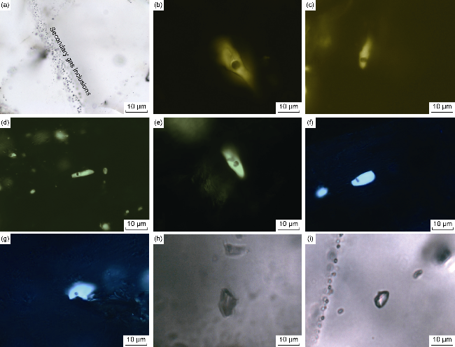
Fig. 5. Hydrocarbon inclusions in the Ordovician fault-karst dolomite reservoirs in the non-foreland area of the Tarim Basin. (a) Secondary gaseous inclusions distributed along calcite in microfractures, Well GL2, 7 391.0 m, plane polarized light; (b) yellowish-green oil inclusions, Well HD301, 6,464.3 m, fluorescence; (c) yellowish-green oil inclusions, Well YM5, 7 213.0 m, fluorescence; (d) blue-green oil inclusions, Well YM2, 7 218.0 m, fluorescence; (e) blue-green oil inclusions, Well YM5, 7 213.0 m, fluorescence; (f) light blue oil inclusions, Well YM6, 7 308.0 m, fluorescence; (g) light blue oil inclusions, Well YM5, 7 213.0 m, fluorescence; (h-i) black primary gaseous inclusions (methane), Well MS2, 8 075.0 m, plane polarized light. |
4. Reservoir-formation and hydrocarbon-accumulation effects
The ages of calcite and quartz veins, clumped isotope temperatures, fluid inclusion homogenization temperatures, combined with characteristics and distribution of hydrocarbon inclusions, lay a foundation for reconstructing the tectonic-burial history and studying the reservoir-forming and hydrocarbon accumulation effects of strike-slip faults.
4.1. Reconstruction of tectonic-burial history
A reliable tectonic-burial history provides an important basis for reconstructing the hydrocarbon generation and expulsion history of source rocks, the diagenetic and pore evolution history of reservoirs, and the stages and history of hydrocarbon accumulation in petroliferous basins, so it has become one of the research hotspots for geologists [37-38]. However, there remains a considerable uncertainty due to the difficulty in determining the thickness of eroded strata. Previous researchers applied various paleothermometer methods [39-40] (e.g., apatite and zircon fission track dating, apatite and zircon (U-Th)/He dating, vitrinite reflectance measurement), but these methods are almost applicable for siliciclastic rocks. Even though the apatite and zircon samples selected are nearly synchronous with the siliciclastic rocks, and the paleogeothermal history can be reconstructed by measuring the fission track temperatures of apatite and zircon, it is impossible to obtain a series of isotopic ages in the geological period through zircon dating, nor to construct the tectonic-burial history in an absolute age coordinate system.
Application of the in-situ laser ablation U-Pb isotope dating of carbonate minerals and quartz, combined with fluid inclusion homogenization temperature and clumped isotope thermometry, provides a technical solution for reconstructing the tectonic-burial history of carbonate layers [23]. Different from apatite and zircon, carbonate cements exhibit multiple cementation stages and may be younger than the host strata. As long as the calcite/quartz cements that can basically represent a continuous and complete filling sequence are identified, the tectonic- burial history curve in an absolute age coordinate system can be quantitatively reconstructed by determining their ages and temperatures, and combined with the understanding of the geothermal gradient and tectonic movement episodes.
The 38 groups of age and temperature data (Table 1, Fig. 4) basically represent the relatively continuous and complete filling sequence of calcite and quartz cements in the geological history. By converting temperature into depth based on the geothermal gradient [22,41], the Cambrian-Ordovician tectonic-burial history in the study area is reconstructed (Fig. 6). The age-temperature relationships of calcite and quartz veins (Fig. 4b) also reflect the tectonic-burial history of the target interval in the study area, only without converting temperature into depth. The greatest advantage of reconstructing the tectonic-burial history under the constraint of age and temperature is that there is no need to restore the thickness of eroded strata. The reconstructed tectonic-burial history reveals that the Cambrian-Ordovician strata in the study area have been in a continuous subsidence process as a whole, despite the uplift at the end of the Silurian period.
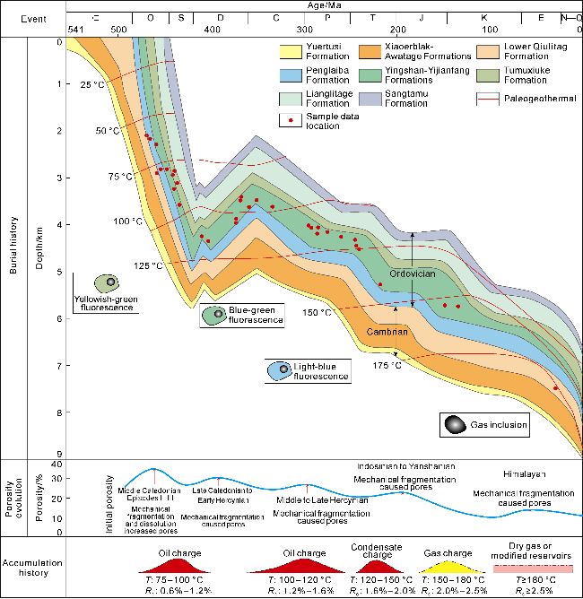
Fig. 6. Quantitative reconstruction of the burial history, pore evolution history, and hydrocarbon accumulation history of the Ordovician fault-karst reservoirs in the basin-platform area of the Tarim Basin under the constraint of isotopic ages and temperatures (T—formation temperature, Ro—vitrinite reflectance). |
4.2. Reservoir-forming effect of strike-slip faults
Plentiful achievements have been made in research on the reservoir-forming effect of strike-slip faults. Liu et al. [3] proposed that the horizontal segmentation of strike-slip faults controls the development of fractured-vuggy systems. The tension-torsion segment exhibits the most developed fractured-vuggy system, dominated by cave, vuggy, and fractured-vuggy reservoirs. The compression-torsion segment comes second, and mainly develops vuggy and fractured-vuggy reservoirs. The translation segment is primarily associated with fractured reservoirs. Ma et al. [42] suggests that the development of fractured-vuggy systems is controlled by the vertical variation of strike-slip faults and reservoir lithology, and their formation is the result of the coupling between strike-slip faults and paleokarst surfaces. The Ordovician limestone was pointed out to be the lithology and interval for the advantageous development of fractured-vuggy systems. Li et al. [15] reported that the development of fractured- vuggy systems is also related to deep burial and hydrothermal karstification. The above understandings are generally the qualitative and static characterization of the reservoir-forming effect of strike-slip faults, without investigating the genesis and evolution process of fractured-vuggy systems from dynamic and quantitative perspectives.
Interbreccia pores, cavities and tectonic fractures induced by the activity of strike-slip faults are important reservoir spaces [43]. Controlled by the tectonic stress field, both walls of strike-slip faults undergo compression and tension-torsion, forming fracture zones roughly parallel to the fault planes. Even without meteoric freshwater dissolution, these zones that extend nearly a kilometer and extensively are favorable reservoirs, called "faulted- fractured bodies" [44], which are channels for subsequent meteoric freshwater and hydrothermal fluids. The scales and characteristics of the reservoir spaces formed by different faults, different segments of a fault, major faults and their branches are various.
Under the influence of strike-slip faults and interlayer karstification, early interbreccia pores, cavities, and structural fractures are leached into larger vugs or caves by meteoric freshwater. Rock surface dissolution simulation experiments have revealed that lithology exerts a crucial control on the development of pores and vugs. The dissolution rates of dolomite, sparry calcite, micrite, and micritic grains increase successively [45]. Therefore, packstone (mainly developed in the Yijianfang Formation and the upper member of the Yingshan Formation) represents the preferential lithology for the development of karst fractures, vugs, and pores in the Tarim Basin. Interlayer karst surfaces and faults are the primary controlling factors for the development of fractured-vuggy systems. However, the development of karst fractures and vugs beneath the karst surfaces and on both sides of the faults is governed by lithology. The development potential of karst fractures and vugs decreases from packstone, wackestone, micrite limestone to grainstone. Although patterns a, c and d strike-slip faults have undergone multiple tectonic events, the tectonic activities during the Middle Caledonian Episodes II and III, coupled with interlayer karstification, have achieved the most significant enhancement on pores and vugs (Fig. 2). During these periods, surface runoff on the top of the Yijianfang Formation and the Lianglitage Formation brought abundant freshwater into the active strike-slip faults, facilitating the formation of numerous dissolution pores and vugs in the limestone layers in the upper Yingshan Formation, Yijianfang Formation, and Lianglitage Formation. Although the lower member of the Yingshan Formation, which is composed of limestone, is possibly located within the depth range affected by freshwater, its lithology hinders the formation of vugs. Pattern b strike-slip faults are not conducive to the formation of dissolution pores and vugs due to the absence of the synergistic effect of interlayer karstification, the poor solubility of dolomite, and the underdeveloped fracture networks induced by highly steep strike-slip faults.
Two sets of age data of the calcite cements (C1) in dissolution pores and vugs ((458.0-459.0 Ma, 441.0-448.0 Ma) further reveal the dissolution and cementation events by meteoric freshwater during the Middle Caledonian Episodes II and III. The strike-slip faults coupled with interlayer karstification (surface runoff) during the Middle Caledonian Episode II triggered the development of dissolution pores and vugs in the upper Yingshan Formation and Yijianfang Formation, while the same coupling during the Middle Caledonian Episode III promoted the formation of dissolution pores and vugs in the Lianglitage Formation. The calcite cements are characterized by high negative δ18O values (-8.253‰ to -5.936‰), low positive δ13C values (1.007‰ to 1.502‰), and elevated 87Sr/86Sr ratios (0.709 30 to 0.709 46), and clumped isotope temperatures ranging from 60 °C to 80 °C. These geochemical and temperature data represent a typical meteoric freshwater diagenetic environment [46] (Fig. 6).
Hydrothermal activity can either create pores through dissolution or destroy them by filling with hydrothermal minerals [47-48]. Two sets of age data of marco-crystalline calcites (C4-C5, C6) filling in dissolution pores and vugs (295-308 Ma, 240-244 Ma) reveal two stages of hydrothermal activity during the Middle-Late Hercynian and Indosinian periods. These calcites likely decrease the porosity by filling in the pre-existing pores or hydrothermal dissolution pores and vugs. The calcite cements are characterized by high negative δ18O values (-12.463‰ to -8.736‰), low positive δ 13C values (1.834‰ to 2.033‰), and relatively low 87Sr/86Sr ratios (0.708 70- 0.708 74). The common presence of liquid-gas brine inclusions, along with relatively high clumped isotope temperatures and homogenization temperatures (75 °C- 125 °C), collectively represents typical geochemical and temperature features of a burial-hydrothermal diagenetic environment [46] (Fig. 6).
Based on the above analyses and available well and seismic data, and assuming an initial matrix porosity of 25% for the limestones of the Yijianfang, Yingshan, and Lianglitage Formations, compaction and dissolution progressively reduced the matrix porosity to the present-day 2%. In contrast, physical fragmentation and meteoric freshwater leaching are processes that increase porosity. From south to north, karstification gradually intensifies while mechanical fragmentation weakens. Consequently, these processes generally counteract each other. The average porosity of the present-day fractured-vuggy systems within the strike-slip fault zones is estimated to be 10% (Fig. 6).
4.3. Hydrocarbon accumulation effect of strike-slip faults
Previous studies on the hydrocarbon accumulation effect of strike-slip faults through oil-source correlation revealed that oil in the Ordovician fault-controlled reservoirs within the non-foreland area of the Tarim Basin is primarily sourced from the Lower Cambrian Yuertusi Formation source rocks. Fault activities control the opening of vertical pathways and hydrocarbon migration. Two major hydrocarbon accumulation phases have been determined: the Late Caledonian and the Late Hercynian periods [16,30]. However, these studies are static, namely focusing on source rock evaluation and reservoir-source assemblages, instead of dynamic analyses from the tectonic-burial, hydrocarbon generation and accumulation, and reservoir porosity evolution histories.
The tectonic-burial history under the constraint of ages and temperatures reveals that, apart from a secondary uplift at the end of the Silurian, the study area generally underwent continuous burial during the Cambrian-Ordovician period. The process was accompanied by continuous hydrocarbon generation and a gradual increase in Ro (vitrinite reflectance) (Fig. 6). The diagenetic-porosity evolution history shows that while mechanical compaction and dissolution reduced the matrix porosity, the physical fragmentation induced by the strike-slip fault activities during the Middle Caledonian II and III episodes created a large number of interbreccia pores, cavities, and structural fractures, which provide pathways for surface runoff, resulting in the development of widespread vugs in conjunction with interlayer karstification. This represents the main phase for the formation of fracture-vug systems in the upper Yingshan, Yijianfang, and Lianglitage Formations (Fig. 6). These reservoir spaces are effective for the accumulation of hydrocarbon generated during the Late Caledonian and subsequent periods.
The calcite veins (C2) and the yellowish-green oil inclusions in them predict the host minerals aged 434-439 Ma, representing the first phase of oil charging during the Middle-Late Caledonian period, when the paleotemperature was 75-100 °C. It is a window of medium-low mature liquid hydrocarbons. The tectonic uplift at the end of the Silurian period caused stagnant hydrocarbon generation in the Devonian period. The calcite veins (C4) and the blue-green oil inclusions in them declare the host minerals aged 285-350 Ma, suggesting the second phase of oil charging during the Middle-Late Hercynian period, when the paleotemperature rose to 100-120 °C. It is a window of medium-high mature liquid hydrocarbons. The calcite veins (C6) and the light blue oil inclusions in them yield the host mineral aged 215-245 Ma, indicating the condensate charging stage during the Indosinian period, when the paleotemperatures ranged from 120 °C to 150 °C. It is a window of high mature liquid hydrocarbons. The calcite veins (C7) with black primary gas inclusions yield the host minerals aged 148 Ma, representing the natural gas charging stage during the Middle Yanshanian period, when the paleotemperature was over 150 °C. It is a window of high-over-mature hydrocarbons. The Late Yanshanian-Himalayan period saw dry gas generation (driven by continuous burial) or reconstructed hydrocarbon reservoirs (driven by tectonic uplift).
In summary, the Ordovician fault-karst hydrocarbon reservoirs in the non-foreland area of the Tarim Basin experienced four major charging stages (Fig. 6). Compared with previous researches, this study adds absolute ages as quantitative constraint and identifies two additional accumulation stages: the Indosinian and the Middle Yanshanian. This indicates that the hydrocarbon accumulation process is continuous, and consistent with the continuous burial of source rocks. Variations in the accumulation process exist among different strike-slip faults and different segments of the same fault. Specifically, oil accumulation is concentrated in the northern and western parts, and gas accumulation in the southern and eastern parts [49]. This is attributed to the following two reasons. (1) Differences in the burial depth of source rocks across different tectonic units led to variations in Ro (vitrinite reflectance) of the source rocks during the same accumulation period. (2) Not all strike-slip faults experienced all four accumulation stages, which are related to the factors such as their active periods, connectivity to hydrocarbon sources, and capability to effectively control hydrocarbon accumulation. In general, the Ro in the northwestern part is low, and early fault controlled early hydrocarbon accumulation; in the southeastern part, the Ro is high, and late fault activities controlled late hydrocarbon accumulation.
5. Conclusions
The tectonic-burial history reconstructed under the constraint of the isotopic ages and temperatures reveals that the non-foreland area of the Tarim Basin experienced a continuous burial process during the Cambrian-Ordovician period, with only a minor uplift at the end of the Silurian. It is a continuous hydrocarbon generation process with a gradual increase in vitrinite reflectance (Ro).
While mechanical compaction and dissolution progressively reduced the matrix porosity, the strike-slip fault activity during the Middle Caledonian II and III episodes induced physical fragmentation, creating a large number of interbreccia pores, cavities, and structural fractures, which provide pathways for surface runoff. And in conjunction with interlayer karstification, they brought the development of widespread vugs. This constitutes fractured-vuggy systems in the Ordovician limestone, providing effective space for hydrocarbon generated during the Late Caledonian period and later.
Hydrocarbon inclusions and the isotopic ages of their host minerals reveal that the Ordovician fault-karst limestone reservoirs underwent four stages of hydrocarbon accumulation: low-medium mature liquid hydrocarbon accumulation during the Middle-Late Caledonian, medium-high mature liquid hydrocarbon accumulation during the Middle-Late Hercynian, high mature liquid hydrocarbon accumulation during the Indosinian, and high-over mature gas accumulation during the Middle Yanshanian. Variations in hydrocarbon accumulation among different strike-slip faults or different segments of the same fault are controlled by differences in source rock maturity across structural units, the timing and stage of fault activity, and fault-controlled connectivity to hydrocarbon sources.