

Introduction
In the context of global energy low-carbon transformation, natural gas is generally regarded as the most realistic transitional energy source in the path of “carbon peaking and carbon neutrality”. The 43rd Cambridge Energy Research Associates Week (CERAWeek) in 2025 pointed out that natural gas has become a core transitional resource for energy transition and its strategic importance continues to grow [1]. The International Energy Agency (IEA) forecasts that by 2040, natural gas will account for more than 25% of global primary energy consumption, with unconventional natural gas contributing more than 40% of the increasement [2]. It is of great significance to research the resource evaluation and distribution law of coal-rock gas, as a new type of natural gas with the largest-scale potential in the unconventional natural gas family, to ensure natural gas supply and optimize the global energy pattern.
Since the 1950s, North America began to work on coal-mine gas governance, and San Juan Basin, for example, entered the era of commercial coalbed methane production marked by the adoption of drainage depressurization and desorption methods [3-4]. Since then, the global production of this shallow coalbed methane has experienced a rapid increase followed by a decline, and its contribution to global natural gas production has continued to decline after peaking [5]. In order to continue the production, the countries have made many attempts to the Piceance, Cooper, Tunguska and Kuznetsk basins in depth, following the idea of traditional coalbed methane [6-17]. Kuuskraa et al. [18] analyzed and predicted the permeability of deep coal rocks, and made a simple statistical estimate of the natural gas resources in the deep coal rocks of some countries and basins. However, the overall exploration of natural gas in deep coal-rock in other countries is limited by the understanding of deep low-permeability reservoirs and the geological theory of coalbed methane, as well as the limitations of reservoir stimulation technology, and thus no large-scale commercial breakthrough has been made. In recent years, the petroleum explorers in China took the exploration approach with deep coal rocks as oil and gas reservoirs. Specifically, research has been carried out on the natural gas accumulation mechanism in deep coal- rock reservoirs in the perspective of total petroleum system. With the horizontal drilling and multi-interval fracturing technology, exploration discoveries of coal-rock gas have been realized successively at depths over 2 000 m in the basins such as Junggar and Ordos, and large- scale commercial development has been achieved in the Ordos Basin [19-24]. In 2025, the coal-rock gas production of China exceeded 42×108 m3, and the cumulative proven geological reserves exceeded 1.0×10¹² m3, which indicates the great exploration and development potential of coal-rock gas [20,25 -26]. In 2024, Li et al. [20] proposed that the coal-rock gas reservoirs have the characteristics that are significantly different from the traditional coalbed methane, such as deeper burial, rich free gas and adsorbed gas, high gas saturation, high temperature and high pressure, no requirement of drainage for depressurization during coal-rock gas production, and gas production immediately upon well opening. Some scholars [1,25,27] pointed out that the coal-rock gas revolution in China will have a significant impact on the natural gas industry, and it is expected to inject huge strategic potential into the global energy development pattern. Hence, coal-rock gas will become the main part for China’s future natural gas reserves and production increase and an important strategic replacement resource for sustainable development.
Upon the systematic research, the authors believe that according to the whole process of hydrocarbon accumulation in the total petroleum system theory, the natural gas existing in coal-rock reservoir can be called coal-rock gas collectively, which is a generalized concept of coal- rock gas. Based on the understanding of coal-rock gas accumulation process, the control of coal-rock burial depth over gas reservoirs, and respect to the historical usage of coalbed methane terminology, coal-rock gas can be broadly classified into 4 types under 2 categories: deep coal-rock gas (protogenetic coal-rock gas and regenerated coal-rock gas) and shallow coalbed methane (residual coal-rock gas and biogenic coal-rock gas). In theory, there should be a transition zone between the deep coal-rock gas and the shallow coalbed methane, with a depth of approximately 1 500 m, and there may be differences among different basins [26-27]. The coal-rock gas as referred to in the industry at present is the deep coal-rock gas, and the coalbed methane referred is the shallow one., In this paper, the coal-rock gas referred in this paper is the deep coal-rock gas, unless otherwise specified.
Based on the understanding that coalbed methane is mainly composed of adsorbed gas, previous studies have made resource evaluation on global coalbed methane. The geological resources estimated by different methods are (78-849)×1012 m3 [28-34], mainly (180-230)×1012 m3, which may also include some coal-rock gas. As for coal-rock gas, no systematic resource potential evaluation has been performed in the world.
With the data of regional geology, seismic, drilling, well logging and production dynamics obtained from 94 major coal-bearing basins worldwide, comparison was made to the tectonic-sedimentary and burial-thermal evolution conditions of coal rocks in Chinese basins are compared using the established definition methods and evaluation criteria for coal-rock gas in China [26] based on the evaluation of global coal resources and the geological resource potential of global coal-rock gas was estimated mainly by the volume method, partly by the volumetric method in selected regions. According to the evaluation indicator system comprising 14 parameters under 5 categories and the associated scoring criteria, the target basins are ranked, and the future research directions for these basins are proposed, expecting to provide a resource basis for global coal-rock gas exploration and development.
1. Global coal resource statistics and distribution
The scale and distribution of coal-rock gas are generally defined by the amount and regional distribution of coal resources. In the past, the coal resources were mainly evaluated based on the burial depth of recoverable coal, and later the evaluation is extended to the exploration depth of shallow coalbed methane (about 1 200 m or less). Some deep coal resources have not been counted, which affects the understanding to the distribution of coal rocks. Therefore, the author first determined the deep coal resources and their distribution, laying a foundation for the evaluation of coal-rock gas resources.
1.1. Coal resources evaluation
The 468 petroliferous basins worldwide were classified according to the classification scheme of six types [35]. First, the basins accounting for the top 90% of area were selected, and then 94 major coal-bearing basins were finally selected with reference to the research reports of the United States Geological Survey (USGS), the International Energy Agency (IEA) and the U.S. Energy Information Administration (EIA), the government reports of resource countries, the data of commercial companies such as Standard & Poor’s (S&P), the public literature, and the available oil and gas drilling, completion and seismic data of our research team. They include the 38 basins evaluated by the authors according to coalbed methane approach, the basins with coalbed methane discovery in the oil and gas database of S&P, and coal-bearing basins with a burial depth greater than 1 500 m in the reports of coal research institutions around the world. It should be noted that global coal sedimentation is not limited to the petroliferous basins. Some deposition zones buried shallowly since the Neogene, smaller coal-accumulation areas without oil and gas discoveries, and a large number of small petroliferous basins (less than 10% of the area) are not included in the evaluation scope of this paper.
In this study, the authors evaluated the coal resources using the volume and analogy methods. Herein, the deep coal rocks in the basins were tracked based on the seismic, drilling and other exploration data with the proven layers of coal and coalbed methane as clues. Thus, the spatial distribution of coal rock development in the basins was determined to the maximum extent. Drawing on the research results of coal-rock gas resource evaluation in China [26], the lower limit for current burial depth of coal rock statistics is set to 6 000 m. In addition, the statistical lower limit of the thickness of a single coal-rock layer is set to 1 m by considering the drilling capacity of the horizontal wells. In the calculation of coal resources, the coal rock thickness takes the total thickness of coal seams, excluding the thickness of non-coal layers (such as mudstone, siltstone and calcareous interbeds with porosity less than 2%) that can be statistically identified and recognized by existing technologies. The coal rock density is the measured values of well locations in the basins or the predicted values of the change trend with the burial depth.
1.2. Coal resources and their distribution
The results of the dissection and statistics of 94 major coal-bearing basins in the world show that the coal rocks in the world are mainly developed in four types of swamp environments within four types of basins such as foreland, craton, rift and back-arc, distributed in eight coal-accumulation belts in five coal-forming periods, and a small amount developed in two types of basins such as forearc basins and passive continental margin basins. Globally, coal resources at depths shallower than 6 000 m amount to 42×1012 t, of which approximately 22×1012 t occur at depth less than 1 500 m.
According to the order of ancient water flow direction and depositional relief from high to low, the coal-forming environments are successively swamps in glacial meltwater lake, river, delta-lake, and marine-continental transitional facies. Each sedimentary facies can be divided into 1 to 3 subfacies. The coal development characteristics of different sedimentary environments are shown in Table 1. The foreland basins, represented by the Alberta Basin, are characterized by the coal rocks mainly formed in the littoral-neritic sea during the extension-depression period and the delta plain swamps during the compressional inversion period, with many layers and wide distribution. Specifically, there are 9 sets of coal rock layers, with burial depth of 0-3 600 m, including 8 sets of Upper Cretaceous coal rock layers, with a cumulative thickness up to 320 m, and a distribution area of 25.8×10⁴ km2 [2,6,30,36]. The coal resources are 6.06×10¹² t. The net coal in Lower Cretaceous Series has thickness of 0-10 m, with an average of 6 m, distribution area of 11.0×10⁴ km2, and coal resources of 0.92×10¹² t. Craton basins, represented by the East Siberian Basin, are characterized by the coal rocks primarily developed in glacial meltwater lake and river swamps formed during the late inversion stage of depression period, with unstable distribution and thickness. Three coal seams are developed: the Carboniferous Katzk Formation (C2K), the Permian Burgukla Formation (P1bg) and the Peryatka Formation (P2pt). The coal rocks are buried at depths of 1 000- 4 000 m, with approximately 16-44 coal seams with the single-layer thicknesses of 1-25 m, and a distribution area of 45×104 km2 [2,6,36,37]. The total coal resources are estimated at 2.30×10¹² t. The rift basins, represented by the South Turgay Basin, are characterized by the coal rocks mainly developed in the inland delta and littoral swamp of the Early to Middle Jurassic during the fault-depression transition period, with large cumulative thickness and continuous distribution. The Jurassic Sazimbai Formation (J1sb) is buried at depth of 690-5 300 m, with a cumulative net coal thickness of 0-280 m, and is mainly distributed in the Aryskum Sag. The Jurassic Doshan Formation (J2ds) is buried at depth of 690-4 900 m, with a cumulative net coal thickness of 0-123 m, and is mainly distributed in the Aryskum Sag. The Jurassic Karagansky Formation (J2kr) is buried at depth of 10-3 500 m, with a cumulative net coal thickness of 0-69 m, and is distributed in the Sarylan Sag and the South Akshabulak Sub-sag. The distribution area of coal rock in the basin is 8×10⁴ km2, and the coal resources are 1.28×10¹² t. Back-arc basins, represented by the South Sumatra Basin, are characterized by coal rock formations mainly developed in deltaic plains during the inversion and re-construction period, with small individual layer thicknesses, poor continuity, and distribution in bands or lenses. The coal rocks are mainly developed in the Neogene Muara Enim Formation (N1me), with burial depths ranging from 80-2 400 m, individual layer thicknesses within the range of 2-15 m, and cumula-tive thicknesses within the range of 50-100 m. The coal thickness gradually increases from northeast to southwest. The distribution area of coal rock is 2×10⁴ km2 [2,6,30,36], and the coal resources amount to 0.51× 10¹² t.
Table 1. Four types of swamp environments and coal component characteristics of global coal rocks |
| Relief | Sedimentary facies | Distribution characteristics | Characteristics of coal components | Representative basin, region and layer |
|---|---|---|---|---|
High Low | Glacial meltwater lake | Larger lateral range, many longitudinal layers, and thicker single layer | Rich vitrinite, low ash and low sulfur | Carboniferous-Permian in West Siberian Basin, Carboniferous in Ruhr Basin |
| River | Smaller lateral range, few longitudinal layers, and thinner single layer | Medium inertinite, high ash, low sulfur | Cretaceous in Erlian Basin, Carboniferous in western Appalachian Basin | |
| Delta-lake | Larger lateral range, more longitudinal layers, and thicker single layer | Vitrinite, low sulfur | Jurassic in Ordos Basin, Carboniferous in middle Appalachian Basin | |
| Marine- continental transitional | Maximum lateral range, maximum longitudinal layers, and thinner single layer | Rich exinite, high sulfur | Permian Longtan Fm. in South China, Permian Taiyuan Fm. in North China, Cretaceous in Alberta Basin, Paleogene in South Sumatra Basin |
Except that Silurian-Devonian boghead coal and psilophyton coal are limited to small-scale deposition, there are five main coal-forming periods in the world, as shown in Table 2. Carboniferous coal rocks are mainly distributed in three foreland basin groups: Appalachia, Mediterranean-Central Asia section of Tethys domain, and Ural. The Permian coal rocks are mainly enriched in the basins (mainly craton) in the southern Gondwana continent in Pangea Supercontinent, such as Bowen Basin and Cooper Basin in the central and eastern parts of Australia, Karoo Basin in South Africa, Deccan Plateau in India, East Siberian, and the North China Craton. These basins were unified during that period. Jurassic coal rocks are distributed in the Kazakhstan-Junggar-Mongolia block amalgamated basin groups formed by the closure of Paleo-Asian Ocean (such as South Turgay, Junggar, Erlian basins), and the southern Central Asia back-arc extensional basin groups caused by the northward subduction of the Neo-Tethys Ocean (such as Tarim Basin and Ferghana Basin). Cretaceous coal rocks are enriched in the foreland basin group in Cordilleran orogenic belt, such as the SN-trending back-arc prototype basins formed on the east side of Rocky Mountain orogenic belt in North America. Paleogene-Neogene coal deposits occurred during the Himalayan orogeny, in the lignite basins of Yunnan, China and Southeast Asia formed by the collision of the India-Eurasian plates, and in the back-arc basins (such as Indonesia Sumatra Basin) formed by the Neogene circum-Pacific volcanic arcs, and the forearc basins (such as Pugets) in the United States.
Table 2. Main coal-forming periods, coal rock distribution and palaeoenvironmental characteristics in the world |
| Coal-forming period | Distribution areas and basins | Palaeoenvironment | ||
|---|---|---|---|---|
| Prototype basin | Palaeosedimentary environment | Palaeoclimate | ||
| Carboniferous | Appalachia, Mediterranean-Central Asia section of Tethys domain, and Ural orogenic belt | Foreland basin | Transitional swamp | Subtropical hot and humid climate |
| Permian | Karoo in South Africa, East Siberian Basin, North China Craton | Craton basin | Glacial meltwater lake swamp and delta-lake swamp | Subtropical alpine climate |
| Jurassic | Foreland basin group of Tethys domain, strike-slip pull-apart basin group in eastern Mongolian block | Foreland/ Depression basin | Delta-lake swamp | Temperate seasonal arid climate |
| Cretaceous | Rocky Mountain orogenic belt in North America | Foreland basin | Transitional swamp | Subtropical humid and warm climate |
| Paleogene- Neogene | India-Eurasia plate collision arcs in Southeast Asia, circum-Pacific volcanic arcs | Back-arc/ Forearc basin | Transitional swamp | Tropical rainforest climate |
The distribution of coal-bearing basins and layers in the eight major coal-accumulation belts is shown in Fig. 1, including: (1) the foreland basin group in Cordilleran orogenic belt in western North America (Cretaceous, Paleogene, and Neogene), such as Alaska North Slope, Rocky Mountain, Alberta, Powder River, San Juan, Anadarko and other basins; (2) the foreland basin group in Appalachian orogenic belt in eastern North America (Carboniferous and Permian) and the East European craton basin group (Carboniferous and Permian), such as the Appalachian, Black Warrior, Dnieper-Donets, Moscow and other basins; (3) the craton basin group (Paleogene) in North America, such as Williston, Michigan, Forest City and other basins; (4) the Eurasian craton basin group (Carboniferous, Permian, Jurassic), such as East Siberian, West Siberian, Ordos and other basins; (5) the foreland basin group in Ural orogenic belt of Russia (Carboniferous and Permian), such as Timan-Pechora, Volga-Ural, Precaspian and other basins; (6) the foreland basin group (Carboniferous, Jurassic) in Tethyan tectonic domain, such as Amu-Darya, Tarim (Kuqa Depression), Junggar, Qaidam and other basins; (7) the craton basin group (Permian) in southern Gondwana (Africa, South America) tectonic domain, such as Chaco-Parana, Kalahari, Karoo, Cooper, Bowen and other basins; and (8) the West Pacific back-arc basin group (Paleogene, Neogene), such as South Sumatra, Central Sumatra and other basins.
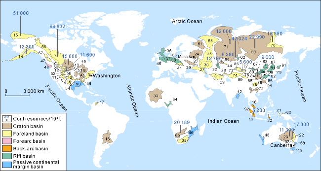
Fig. 1. Distribution of coal resources in the major global coal-bearing basins. 1 — Williston Basin; 2 — Paradox Basin; 3 — San Juan Basin; 4 — Raton Basin; 5 — Permian Basin; 6 — Anadarko Basin; 7 — Alberta Basin; 8 — Michigan Basin; 9 — Appalachian Basin; 10 — Southwest Montana Basin; 11 — Great Green River Basin; 12 — Wyoming Basin; 13 — Powder River Basin; 14—Cook Inlet Basin; 15 — Alaska North Slope Basin; 16 — Chaco-Parana Basin; 17 — Maracaibo Basin; 18 — Malay Basin; 19 — South Sumatra Basin; 20 — Bone Basin; 21 — Bintuni Basin; 22 — Bowen Basin; 23 — Cooper Basin; 24 — Moscow Basin; 25 — Volga-Ural Basin; 26 — Ryazan-Saratov Basin; 27 — North Caucasus Basin; 28—Ferghana Basin; 29 — Afghan-Tajik Basin; 30 — Precaspian Basin; 31 — Amu-Darya Basin; 32 — South Turgay Basin; 33 — Taoudeni Basin; 34 — Benue Basin; 35 — Karoo Basin; 36—North Sea Basin; 37 — Northwest German Basin; 38 — Northeast German-Polish Basin; 39 — Dnieper-Donets Basin; 40 — Anglo-Dutch Basin; 41 — North Carpathian Basin; 42 — Mahanadi Basin; 43 — Perth Basin; 44 — Karaganda Basin; 45 — Gippsland Basin; 46 — Mozambique Basin; 47 — Nechako Basin; 48 — Puget Basin; 49 — Lake Superior Basin; 50 — Bighorn Basin; 51 — Wind River Basin; 52 — Uinta Basin; 53 — Forest City Basin; 54 — Arkoma Basin; 55 — Rocky Mountain Basin; 56 — Black Warrior Basin; 57 — Guba Basin; 58 — Piceance Basin; 59 — Illinois Basin; 60 — South Waropen Basin; 61 — Mezen Basin; 62 — Kuznetsk Basin; 63 — Timan-Pechora Basin; 64 — Tethyan Basin; 65 — Kalahari Basin; 66 — Upper Silesian Basin; 67 — Middle Gobi Basin; 68 — Sydney Basin; 69 — East Siberian Basin; 70 — Lena-Vilyuy Basin; 71 — West Siberian Basin; 72 — East Yunnan-West Guizhou Basin; 73 — Junggar Basin; 74 — Tarim Basin; 75 — Tuha Basin; 76 — Qinshui Basin; 77 — Sangtanghu Basin; 78 — Sichuan Basin; 79 — Yanbian Basin; 80 — Hetao Basin; 81 — Songliao Basin; 82 — Bohai Bay Basin; 83 — Hailar Basin; 84 — Datong Basin; 85 — Hoxtolgay Basin; 86 — Ningwu Basin; 87 — Erlian Basin; 88 — Ordos Basin; 89 — Qaidam Basin; 90 — Gulf Basin; 91 — Sanjiang Basin Group; 92 — Central Sumatra Basin; 93 — Surat Basin; 94 — Southern North China Basin. |
2. Evaluation methods of coal-rock gas resources and basin selection criteria
2.1. Evaluation methods of coal-rock gas resources
The large-scale accumulation of coal-rock gas is mainly controlled by the amount of gas generation and storage capacity of coal rocks. In most parts of the world, coal rocks are Type III organic matter derived from higher plants. Their thermogenic gas generating capacity is mainly controlled by total organic carbon (TOC), coal rank, or vitrinite reflectance (Ro). The gas storage capacity is influenced by the adsorption capacity of matrix surface to methane and the porosity (ϕ) of coal rock. The adsorption capacity is also related to TOC and Ro. Based on the available resource evaluation methods of coal-rock gas [26] and the understanding of coal rock characteristics in 94 coal-bearing basins, the authors determined the values of the critical evaluation parameters (such as the critical depth and gas content of coal-rock gas) in the basins by analogy of the accumulation factors including the basin type, coal-rock depositional age and environment, thermal evolution maturity and preservation conditions after gas production, with reference to the basins in China, and calculated the geological resources using the volume method [20,26] with the following equation:
2.2. Limits and value-determination methods of resources evaluation parameters
2.2.1. Depth range and lower limit of effective thickness for coal-rock gas resources evaluation
According to the value-determination methods of coal- rock gas evaluation parameters for basins in China, the depth at which free gas is contained in the coal-rock reservoir from shallow to deep is taken as the critical depth for the initial evaluation of protogenetic coal-rock gas [26]. This depth is controlled by the terrestrial heat flow, thermal evolution, and degree of later reformation of the basin, which varies in different basins or structural belts. The initial evaluation depth is approximately 2 500 m for the Jurassic coal-rock reservoir in the cold basins (Junggar, Tarim, and Tuha, with Ro values ranging 0.5%-1.0%) in northwestern China. The initial evaluation depth is approximately 2 000 m for coal-rock reservoir in the warm basin (northern Ordos Basin, Bohai Bay Basin and Qaidam Basin, with Ro ranging 1.0%-1.5%). The initial evaluation depth is approximately 1 500 m for coal-rock reservoir in the hot basins (southern Ordos Basin, Songliao Basin and Qinshui Basin, with Ro ranging 1.5%-3.0%) [26]. Generally, the global protogenetic coal-rock gas basins exhibit a linear statistical relationship between terrestrial heat flow and gas-bearing index (Ig), as shown in Fig. 2. The equation for calculating Ig is shown in Eq. (2), which represents the gas potential of coal rock. The greater the value, the higher the proportion or content of free gas is.
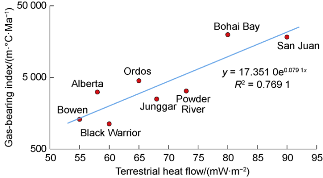
Fig. 2. Relationship between terrestrial heat flow and gas- bearing index of typical coal-rock gas basins in the world. |
The initial evaluation depth of each basin in the world is determined by analogy of geological parameters such as basin type, coal stratigraphic chronology, coal thermal maturity and gas content changes. For some basins with different geological conditions from that in China, the fitting curve is adjusted based on the above statistical rule. Specifically, the rift basins, the forearc basins and the back-arc basins with high terrestrial heat flow are classified as hot basins, while the craton basins and the passive continental margin basins with moderate terrestrial heat flow are classified as warm basins. In this paper, simplified and unified technical treatment is made for the low exploration degree of foreign coal-rock gas. In fact, the critical depth for initial evaluation of coal-rock gas is also affected by many factors such as burial thermal evolution history, gas generation mechanism and coal-rock permeability.
Considering the technical feasibility of coal-rock gas development and the drilling results at this stage, the maximum depth for this coal-rock gas resource evaluation is consistent with that of the basins in China, and the lower limit depth takes 6 000 m.
According to the basin evaluation standard of China [26], the lower limit of the calculated thickness of coal-rock gas reservoir in this coal-rock gas resources evaluation is 1 m, and the lower limits for the evaluation of gas content in the medium-low and medium-high coal ranks are 2 m3/t and 10 m3/t, respectively. Considering the different refinement degrees of overseas basin data, this evaluation takes the coal-rock formation as the statistical unit in the data with low degree of exploration or limited data, and the lower limit of the calculated cumulative thickness of the coal-rock formation is 3 m.
2.2.2. Gas content of coal rock
The total gas content of coal-rock includes both adsorbed gas content (CA) stored in the coal matrix and free gas content (CF) hosted in coal pores. Clearly, the total gas content is the sum of these two components. The value can be obtained through literature or based on other geological parameters. Especially in the case that no gas content data of coal rock in the target basin is available, the following methods are used to obtain the adsorbed gas content and free gas content respectively.
2.2.2.1. Adsorbed gas content
The relationship between adsorbed gas content and pressure is established (Eq. (3)). The values of coefficients a and b in the relationship under different temperature and maturity conditions can be determined based on the isothermal adsorption experimental data (Ro, temperature, pressure, TOC, CA) of coal rocks with different maturities in the publicly available literature. By substituting the current thermal maturity, temperature, pressure of the coal-rock strata in the target basin with the measured TOC values of representative samples from the region, the adsorbed gas content in the coal-rock strata of the target basin can be calculated. Fig. 3 shows the chart of a and b values established using the measured data of 8# coal seam of Carboniferous Benxi Formation in the Daning-Jixian region on the eastern edge of the Ordos Basin as an example [37].
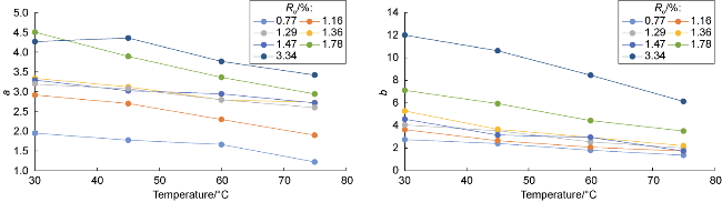
Fig. 3. Chart of coefficients a and b values in the pressure-adsorbed gas content relationship established by the isothermal. adsorption experimental data of coal rocks. |
Or according to the measured adsorbed gas content data of the basins in China, to establish the adsorbed gas content-burial depth chart under different maturity values, and obtain the geological resources of adsorbed gas in coal rocks with specific burial depth in foreign basins through the analogy of coal-rock burial depth and thermal maturity parameters of the basin to be evaluated.
2.2.2.2. Free gas content
Depending on the data availability in the basin, the free gas content was derived from coal-rock porosity. Specifically, if well logging data are available, porosity is inverted from well logging; if profile data on burial thermal evolution are available, coal-rock porosity is obtained via the analogy method based on the relationships between porosity, burial depth, and maturity; if only burial depth is available and other data are unknown, coal-rock porosity at different burial depths is acquired using the statistical relationship between coal-rock burial depth and porosity.
2.3. Selection methods and standards of key basins
On the basis of understanding the geological characteristics and resource potential of coal-rock gas in global major basins, the analytic hierarchy process is used to establish a parameter indicator system and scoring criteria for evaluation and selection of key basins for global coal-rock gas exploration and development. According to the Pareto principle, resource potential, geological development conditions, engineering conditions, comprehensive risks, laws, and contracts were selected as first-level parameters, while 14 key elements—including geological resources, permeability, and infrastructure—were designated as second-level parameters. According to the Pareto principle, the resource potential, development geological conditions, engineering conditions, comprehensive risks, laws and contracts are taken as the level-1 parameters, and the 14 key elements such as geological resources, permeability and infrastructure are taken as the level-2 parameters. Based on the risk evaluation models of foreign resource strategic selection areas by predecessors and the weight setting of evaluation parameters for S&P's petroleum exploration and development attraction rate [38-39], weights are assigned to the first-levellevel-1 and sec-ond-levellevel-2 evaluation parameters. The parameters are scored on a 100-point scale. The second-levellevel-2 parameters of comprehensive risks are assigned based on the situation of conventional oil and gas in various countries, and the second-levellevel-2 parameters of laws and contracts are assigned based on the situation of coalbed methane and conventional oil and gas in various countries. The parameter indicator system and scoring criteria for basin evaluation and selection are listed in Table 3.
Table 3. Parameter index and scoring criteria for evaluation and selection of key coal-rock gas basins |
| Level-1 parameter | Level-1 parameter weight/% | Level-2 parameter | Level-2 parameter weight/% | Scoring standard for level-2 parameters (full score: 100 points) |
|---|---|---|---|---|
| Resource potential | 45 | Geological resources | 100 | 100 points for the basins with maximum geological resources, and the points of other basins are calculated by the percentage of geological resources to the maximum geological resources |
| Geological conditions | 25 | Gas content | 30 | 100 points for the basins with gas content greater than 18 m3/t, and 30 points for the basins with gas content less than 8 m3/t. For the basins with intermediate gas content, the points decrease proportionally from 100 to 30 points |
| Coal-rock thickness | 25 | 100 points for the basins with single-layer thickness larger than 8 m or cumulative thickness larger than 15 m; 30 points for the basins with single-layer thickness smaller than 3 m or cumulative thickness smaller than 5 m. For the basins with intermediate thickness, the points decrease proportionally from 100 to 30 points | ||
| Permeability | 20 | 100 points for the basins with permeability greater than 10.0×10⁻³ μm2, and 30 points for the basins with permeability less than 0.1×10⁻³ μm2. For the basins with intermediate permeability, the points decrease proportionally from 100 to 30 points | ||
| Burial depth | 15 | 100 points for the basins where the burial depth of coal-rock gas is less than 3 000 m and 30 points for the basins where the burial depth of coal-rock gas is over 4 500 m. For the basins where the burial depth of coal-rock gas is within 3 000-4 500 m, the points decrease proportionally from 100 to 30 points | ||
| Preservation condition | 10 | 100 points for the basins in stable structures; 60 points for the basins in relatively stable structure with a few fissures; 30 points for the basins in structure with frequent tectonic activities and open fissure | ||
| Engineering conditions | 15 | Technical maturity | 50 | 60 points for the basins with the coal-rock gas buried at a depth shallower than 4 000 m and 40 points for the basins with the coal-rock gas buried at a depth greater than 4 000 m |
| Infrastructure | 30 | 100 points for the basins with complete infrastructures, 60 points for the basins with relatively complete infrastructures, and 30 points for the basins with only a few infrastructures | ||
| Geography and market | 20 | 100 points for the basins with superior geographical conditions and market, 60 points for the basins with favorable geographical conditions and market, and 30 points for the basins with inconvenient geographical conditions and market | ||
| Compre- hensive risk | 10 | Political and economic stability | 50 | 100 points for the basins with stable political and economic conditions, 60 points for the basins with relatively stable political and economic conditions, and 30 points for the basins with unstable political and economic conditions |
| Exploration, development and operation risks | 30 | 100 points for the basins with no exploration, development and operation risks, 60 points for the basins with 2-3 risks, and 30 points for the basins with multiple risks | ||
| Geopolitical risk | 20 | 100 points for the basins with stable international relations and no regional political conflict, and 30 points for the basins with political conflict or international relations tending to deteriorate during the contract period | ||
| Law and contract | 5 | Contract and commercial terms | 70 | 100 points for the basins with the contract and license framework, commercial terms, operation requirements, exploration and production rights and interests, contract changes and withdrawal clauses favorable to the investors, 60 points for the basins with the majority of the above items favorable to the investors, and 30 points for the basins with the minority of the above items favorable to the investors |
| Policy support | 30 | 100 points for the basins with clear favorable support policies or legal provisions, 60 points for the basins with the targeted policies or legal provisions promised, and 30 points for the basins with unclear policies or legal provisions |
3. Evaluation results and research directions of global coal-rock gas resource potential
3.1. Evaluation results of geological resources of coal-rock gas
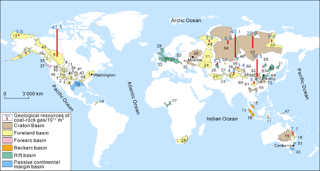
With the coal-rock gas resource evaluation methods mentioned above, the global geological resources of coal-rock gas are evaluated to be approximately 232×1012 m3. Among the 94 basins evaluated, there are coal-rock gas resources distributed in 73 basins. Although the other 21 basins have coal seams distributed in large area, no coal-rock gas is developed due to their shallow burial depth. Globally, coal-rock gas is mainly distributed in Russia (76.4×10¹² m3, accounting for 33%), China (55.3×10¹² m3, accounting for 24%), Canada (47.5×10¹² m3, accounting for 21%), the United States (21.6×10¹² m3, accounting for 9%), and Australia (9.7×10¹² m3, accounting for 4%), with a total proportion over 90% in the world (Fig. 4 and Table 4). The top 10 basins with the largest geological resources of coal-rock gas worldwide are: Alberta Basin, Kuznetsk Basin, Ordos Basin, East Siberian Basin, Bowen Basin, West Siberian Basin, Sichuan Basin, South Turgay Basin, Lena-Vilyuy Basin and Tarim Basin, accounting for 75% of the global resources. Based on current basin types, the resources of the foreland basins, craton basins, rift basins, back-arc basins, forearc basins and the passive continental margin basins are 108.8×10¹² m3 (46.9%), 64.2×10¹² m3 (27.7%), 51.3×10¹² m3 (22.1%), 2.3× 10¹² m3 (1.0%), 3.7×10¹² m3 (1.6%) and 1.6×10¹² m3 (0.7%) respectively. Based on the prototype basin types during the coal deposition period, the resources of the foreland basins, craton basins, rift basins, back-arc basins, the passive continental margin basins and the forearc basins are 128.5×10¹² m3 (55.4%), 70.4×10¹² m3 (30.4%), 16.1×10¹² m3 (6.9%), 12.2×10¹² m3 (5.3%), 3.41×10¹² m3 (1.8%), and 0.54× 10¹² m3 (less than 0.2%) respectively. Based on strata, the resources in Permian, Cretaceous, Carboniferous, Jurassic and Paleogene-Neogene strata are 74.8×10¹² m3 (32%), 70.3×10¹² m3 (30%), 41.6×10¹² m3 (18%), 22.4×10¹² m3 (10%) and 16.1×10¹² m3 (7%) respectively, while the resources of other strata are 6.5×10¹² m3, accounting for 3%.
Fig. 4. Distribution of global geological resources of coal-rock gas. 1 — Paradox Basin; 2 — San Juan Basin; 3 — Raton Basin; 4 — Permian Basin; 5 — Anadarko Basin; 6 — Alberta Basin; 7 — Appalachian Basin; 8 — Southwest Montana Basin; 9 — Great Green River Basin; 10 — Wyoming Basin; 11 — Powder River Basin; 12—Cook Inlet Basin; 13 — Alaska North Slope Basin; 14 — Maracaibo Basin; 15 — Malay Basin; 16 — South Sumatra Basin; 17 — Bone Basin; 18 — Bowen Basin; 19 — Cooper Basin; 20 — Moscow Basin; 21 — Volga-Ural Basin; 22—Ferghana Basin; 23 — Afghan-Tajik Basin; 24 — Precaspian Basin; 25 — Amu-Darya Basin; 26 — South Turgay Basin; 27 — Benue Basin; 28 — Karoo Basin; 29—North Sea Basin; 30 — Northwest German Basin; 31 — Northeast German-Polish Basin; 32 — Dnieper-Donets Basin; 33 — Anglo-Dutch Basin; 34 — Karaganda Basin; 35 — Gippsland Basin; 36 — Nechako Basin; 37 — Puget Basin; 38 — Bighorn Basin; 39 — Wind River Basin; 40 — Uinta Basin; 41 — Forest City Basin; 42 — Arkoma Basin; 43 — Rocky Mountain Basin; 44 — Black Warrior Basin; 45 — Guba Basin; 46 — Piceance Basin; 47 — South Waropen Basin; 48 — Kuznetsk Basin; 49 — Timan-Pechora Basin; 50 — Upper Silesian Basin; 51 — Sydney Basin; 52 — East Siberian Basin; 53 — Lena-Vilyuy Basin; 54 — West Siberian Basin; 55 — East Yunnan-West Guizhou Basin; 56 — Junggar Basin; 57 — Tarim Basin; 58 — Tuha Basin; 59 — Qinshui Basin; 60 — Sangtanghu Basin; 61 — Sichuan Basin; 62 — Hetao Basin; 63 — Songliao Basin; 64 — Bohai Bay Basin; 65 — Hailar Basin; 66 — Hoxtolgay Basin; 67 — Ningwu Basin; 68 — Ordos Basin; 69 — Qaidam Basin; 70 — Gulf Basin; 71 — Sanjiang Basin Group; 72 — Central Sumatra Basin; 73 — Southern North China Basin. |
Table 4. Development of coal rocks, geologic parameters and geological resources of coal-rock gas in major coal-bearing basins worldwide |
| Region | No. | Basin | Current basin type | Coal- rock layer | Prototype basin type (Coal-forming period) | Environment of coal deposition | Burial depth of coal rock/m | Single layer thick- ness/m | Cumulative thickness/ m | Coal-rock area/ 104 km2 | Coal-rock gas area/ 104 km2 | Gas content/ (m3·t-1) | Ro/% | Coal resources/ 108 t | Burial depth for initial evalua- tion/m | Geological resources of coal- rock gas/ 1012 m3 |
|---|---|---|---|---|---|---|---|---|---|---|---|---|---|---|---|---|
| North America | 1 | Alberta | Foreland | K | Foreland | Marine-continental transition | 0-3 600 | 1-16 | 2-320 | 25.8 | 14.0 | 2-21 | 0.5-1.5 | 69 832 | 2 000 | 47.54 |
| 2 | Alaska North Slope | Foreland | K | Passive continental margin | Marine-continental transition | 0-3 200 | 2-10 | 30-120 | 5.0 | 1.6 | 3-9 | 0.8-2.2 | 51 000 | 2 000 | 3.63 | |
| 3 | Powder River | Foreland | E | Foreland | River and delta-lake | 70-3 300 | 15-75 | 30-300 | 6.7 | 4.4 | 2-4 | 0.3-0.7 | 11 600 | 2 500 | 1.10 | |
| 4 | San Juan | Foreland | K2 | Foreland | Marine-continental transition | 150-4 000 | 2-21 | 4-50 | 2.1 | 1.6 | 3-25 | 0.5-1.6 | 3 057 | 2 000 | 2.84 | |
| 5 | Rocky Mountain | Foreland | K2 | Foreland | River and delta-lake | 0-2 600 | 2-10 | 20-80 | 15.0 | 3.1 | 2-17 | 0.4-1.3 | 670 | 2 000 | 2.62 | |
| 6 | Arkoma | Foreland | C | Foreland | Marine-continental transition | 80-2 900 | 1-15 | 10-40 | 1.5 | 1.2 | 4-12 | 0.6-2.5 | 4 200 | 2 000 | 2.20 | |
| 7 | Appalachian | Foreland | C2 | Foreland | Marine-continental transition | 300-3 395 | 1-8 | 5-30 | 7.2 | 6.5 | 3-19 | 0.6-5.5 | 3 168 | 1 500 | 1.39 | |
| 8 | Black Warrior | Foreland | C2 | Foreland | Marine-continental transition | 500-3 570 | 1-5 | 5-20 | 1.8 | 1.3 | 2-19 | 0.6-1.8 | 2 391 | 1 500 | 2.19 | |
| 9 | Piceance | Foreland | K2 | Foreland | Marine-continental transition | 800-3 660 | 3-15 | 10-50 | 1.8 | 1.1 | 2-13 | 0.5-2.1 | 2 200 | 2 000 | 1.17 | |
| 10 | Anadarko | Foreland | C2 | Foreland | River and delta-lake | 1 000-4 600 | 2-10 | 10-35 | 2.6 | 2.5 | 3-10 | 0.5-1.2 | 330 | 2 500 | 0.57 | |
| 11 | Great Green River | Foreland | E | Foreland | River and delta-lake | 200-2 500 | 1-30 | 20-150 | 4.2 | 2.5 | 2-15 | 0.4-1.0 | 665 | 2 000 | 0.42 | |
| 12 | Forest City | Craton | C2 | Foreland | River and delta-lake | 300-3 200 | 1-2 | 10-20 | 1.3 | 0.5 | 5-10 | 0.7-1.1 | 230 | 2 500 | 0.51 | |
| 13 | Wyoming thrust belt | Foreland | E | Foreland | River and delta-lake | 0-2 800 | 2-15 | 10-50 | 3.2 | 0.9 | 2-9 | 0.5-1.2 | 185 | 2 500 | 0.32 | |
| 14 | Southwest Montana | Foreland | E | Foreland | River and delta-lake | 100-2 600 | 1-10 | 5-50 | 2.5 | 0.6 | 3-8 | 0.5-1.0 | 180 | 2 000 | 0.22 | |
| 15 | Paradox | Foreland | K | Foreland | Marine-continental transition | 1 200-3 600 | 3-12 | 10-40 | 3.3 | 0.3 | 5-12 | 0.6-1.5 | 140 | 2 000 | 0.32 | |
| 16 | Wind River | Foreland | E | Foreland | Marine-continental transition | 200-2 700 | 2-8 | 5-45 | 2.5 | 0.7 | 4-9 | 0.4-1.2 | 504 | 2 500 | 0.14 | |
| 17 | Bighorn | Foreland | E | Foreland | River and delta-lake | 150-2 800 | 2-10 | 5-60 | 2.0 | 0.4 | 3-7 | 0.4-1.0 | 95 | 2 500 | 0.13 | |
| 18 | Raton | Foreland | K | Foreland | Marine-continental transition | 200-2 800 | 1-8 | 5-25 | 1.4 | 0.6 | 5-11 | 0.24-1.3 | 18 | 2 000 | 0.12 | |
| 19 | Williston | Craton | E | Craton | Glacier meltwater, river | 150-3 000 | 1-10 | 5-30 | 5.2 | 3.5 | 2-6 | 0.5-1.0 | 15 000 | 2 500 | 0 | |
| 20 | Permian | Foreland | P | Craton | Marine-continental transition | 300-2 400 | 1-6 | 5-20 | 6.5 | 3.4 | 3-10 | 0.6-1.2 | 380 | 2 000 | 0.47 | |
| 21 | Illinois | Craton | C2 | Craton | Marine-continental transition | 300-1 800 | 1-5 | 3-15 | 6.2 | 1.8 | 2-13 | 0.5-1.3 | 1 721 | 2 500 | ||
| 22 | Michigan | Craton | C2 | Craton | Delta-lake | 30-1 850 | 1-3 | 2-10 | 4.9 | 1.2 | 3-7 | 0.5-1.1 | 225 | 2 500 | ||
| 23 | Superior Lake platform syneclise | Craton | T | Craton | Delta-lake | 0-1 100 | 1-2 | 2-10 | 2.4 | 1.0 | 2-5 | 0.4-0.8 | 40 | 2 500 | ||
| 24 | Cook Inlet | Forearc | K, E, N | Foreland | River | 150-3 700 | 1-10 | 5-30 | 3.8 | 0.4 | 3-8 | 0.3-1.0 | 12 300 | 2 000 | 3.17 | |
| 25 | Puget | Forearc | E | Forearc | Marine-continental transition | 100-2 500 | 1-5 | 3-20 | 1.4 | 0.5 | 2-6 | 0.4-0.8 | 544 | 2 000 | 0.54 | |
| 26 | Gulf | Passive continental margin | E, N | Passive continental margin | Marine-continental transition | 110-4 800 | 1-5 | 3-25 | 4.2 | 3.8 | 3-7 | 0.4-1.0 | 1 750 | 2 500 | 0.18 | |
| 27 | Uinta | Foreland | E | Foreland | Marine-continental transition | 300-2 500 | 1-8 | 5-40 | 2.0 | 0.6 | 2-6 | 0.4-0.9 | 68 | 2 000 | 0.02 | |
| 28 | Nechako | Foreland | E | Passive continental margin | Marine-continental transition | 200-3 000 | 1-6 | 5-25 | 1.5 | 0.4 | 3-7 | 0.5-1.0 | 80 | 2 000 | 0.03 | |
| 29 | Guba | Foreland | K | Foreland | River | 100-2 200 | 2-10 | 10-45 | 1.2 | 0.3 | 2-5 | 0.4-0.8 | 70 | 2 000 | 0.02 | |
| Africa | 30 | Kalahari | Craton | P | Foreland | Marine-continental transition | 0-2 400 | 1-8 | 5-50 | 30.0 | 0.8 | 2-4 | 0.3-0.7 | 20 189 | 2 500 | |
| 31 | Karoo | Foreland | P1 | Foreland | Marine-continental transition | 0-2 700 | 1-10 | 5-40 | 7.0 | 1.1 | 2-6 | 0.6-1.2 | 1 155 | 2 500 | 0.07 | |
| 32 | Benue Trough | Rift | K2 | Rift | Delta-lake | 100-2 000 | 1-8 | 5-25 | 4.5 | 0.7 | 2-6 | 0.4-1.0 | 500 | 1 500 | 0.38 | |
| 33 | Moatize | Craton | P | Craton | Lake and river | 0-900 | 2-15 | 10-50 | 0.8 | 0.2 | 4-9 | 0.4-1.0 | 679 | 2 500 | ||
| 34 | Taoudeni | Craton | D | Craton | Marine-continental transition | 0-1 500 | 1-5 | 3-20 | 1.0 | 2-5 | 0.5-1.2 | 1 | 2 500 | |||
| South America | 35 | Maracaibo | Foreland | E, N | Foreland | Marine-continental transition | 300-4 500 | 1-6 | 5-20 | 4.0 | 1.2 | 3-8 | 0.5-1.2 | 2 500 | 2 000 | 2.85 |
| 36 | Chaco-Parana | Craton | P | Foreland | Rive and delta-lake | 200-2 600 | 2-12 | 10-60 | 12.0 | 2.5 | 2-6 | 0.4-1.0 | 5 | 2 500 | 0 | |
| Europe | 37 | Upper Silesian | Rift | C | Rift | Marine-continental transition | 0-2 300 | 1-8 | 5-30 | 0.7 | 0.6 | 4-15 | 0.6-1.6 | 2 000 | 1 500 | 1.10 |
| 38 | Anglo-Dutch | Foreland | C2 | Craton | Marine-continental transition | 200-3 000 | 1-5 | 3-15 | 6.0 | 1.2 | 4-9 | 0.5-1.3 | 220 | 2 000 | 0.45 | |
| 39 | Northwest German | Foreland | C2 | Foreland | Marine-continental transition | 100-2 600 | 1-6 | 5-20 | 1.8 | 0.8 | 4-10 | 0.5-1.4 | 130 | 2 500 | 0.21 | |
| 40 | Northeast German-Polish | Foreland | C2 | Foreland | Marine-continental transition | 0-2200 | 1-8 | 5-25 | 1.2 | 0.5 | 5-12 | 0.5-1.6 | 195 | 1 500 | 0.06 | |
| 41 | Ryazan-Saratov | Craton | C2 | Rift | Marine-continental transition | 0-2 000 | 1-4 | 3-15 | 1.0 | 5-12 | 0.7-1.5 | 13 | 2 000 | |||
| 42 | Mezen | Craton | C2 | Rift | Marine-continental transition | 50-1 800 | 1-5 | 5-20 | 0.8 | 4-10 | 0.6-1.4 | 25 | 2 000 | |||
| 43 | North Sea | Rift | P | Passive continental margin | Marine-continental transition | 1 000-4500 | 1-5 | 3-20 | 3.5 | 0.8 | 3-8 | 0.5-1.2 | 80 | 2 500 | 0.02 | |
| 44 | North Carpathian | Foreland | E | Foreland | River and delta-lake | 0-1600 | 1-3 | 1-6 | 0.3 | 2-5 | 0.3-0.7 | 1 | 2 000 | |||
| Asia-Pacific | 45 | Sichuan | Foreland | P | Craton | Marine-continental transition | 600-6 000 | 1-6 | 2-20 | 9.0 | 5.0 | 15-25 | 1.5-3.5 | 2752 | 1 500 | 5.42 |
| 46 | Tarim | Foreland | T, J1-2 | Foreland | Glacial meltwater lake and river | 1 500-6 000 | 1-22 | 6-55 | 28.0 | 3.8 | 2-13 | 0.8-1.3 | 2 600 | 2 500 | 4.75 | |
| 47 | Tuha | Foreland | J1-2 | Foreland | River and delta-lake | 200-5 000 | 2-15 | 8-80 | 4.9 | 1.9 | 5-20 | 0.5-1.7 | 5 600 | 2 500 | 2.11 | |
| 48 | Junggar | Foreland | J1-2 | Foreland | River and delta-lake | 1 000-6 000 | 5-30 | 10-80 | 4.8 | 2.7 | 4-18 | 0.4-1.2 | 3 900 | 2 500 | 3.41 | |
| 49 | Sydney | Foreland | P | Back-arc | River and delta-lake | 300-1 800 | 1-10 | 5-30 | 2.5 | 0.6 | 5-15 | 0.6-1.8 | 400 | 1 500 | 0.46 | |
| 50 | Hoxtolgay | Foreland | J1-2 | Rift | River and delta-lake | 0-2 000 | 2-10 | 10-40 | 1.2 | 0.3 | 5-11 | 0.4-1.3 | 300 | 1 500 | 0.16 | |
| 51 | Sangtanghu | Foreland | J1-2 | Rift | River and delta-lake | 800-6 000 | 2-8 | 10-30 | 1.0 | 0.5 | 4-9 | 0.4-1.2 | 1 100 | 1 500 | 0.21 | |
| 52 | Qaidam | Foreland | J1-2 | Foreland | Delta-lake | 600-6 000 | 1-6 | 5-20 | 6.0 | 1.9 | 6-15 | 0.7-1.4 | 400 | 2 000 | 2.36 | |
| 53 | Sanjiang group | Rift | K1 | Rift | Delta-lake | 100-3 000 | 6-25 | 10-40 | 1.2 | 0.1 | 8-20 | 0.9-1.5 | 200 | 2 000 | 0.11 | |
| 54 | Hailar | Rift | K1 | Rift | River and delta-lake | 200-3 000 | 5-30 | 20-50 | 1.6 | 0.5 | 4-9 | 0.5-1.2 | 1 000 | 2 000 | 0.53 | |
| 55 | Bohai Bay | Rift | C, P | Craton | Delta-lake | 1 000-6 000 | 1-10 | 5-30 | 3.2 | 2.1 | 4-12 | 0.5-1.5 | 1 000 | 2 000 | 2.47 | |
| 56 | Erlian | Rift | K1 | Rift | Delta-lake | 200-1 500 | 5-20 | 20-200 | 6.5 | 1.0 | 3-8 | 0.5-1.0 | 1 800 | 1 500 | ||
| 57 | South Gobi | Rift | K | Rift | River and delta-lake | 0-800 | 2-15 | 10-50 | 7.0 | 0.9 | 3-7 | 0.5-1.0 | 1 524 | 1 500 | ||
| 58 | Mahanadi | Rift | P | Rift | River | 0-600 | 1-10 | 5-30 | 2.2 | 0.3 | 4-10 | 0.6-1.2 | 600 | 1 500 | ||
| 59 | Ordos | Craton | C, P, J | Craton | Marine-continental transition | 300-6 000 | 1-12 | 5-40 | 25.0 | 18.0 | 5-25 | 0.7-3.0 | 19 000 | 1 500 | 30.49 | |
| 60 | Surat | Craton | J2 | Craton | River | 100-1 000 | 10-30 | 50-200 | 3.0 | 3.0 | 2-9 | 0.3-0.7 | 17 300 | 2 000 | ||
| 61 | Cooper | Craton | P | Craton | Glacial meltwater lake, river and delta-lake | 300-3100 | 1-10 | 5-30 | 11.0 | 7.0 | 2-10 | 0.5-1.5 | 11 300 | 2 000 | 0.70 | |
| 62 | Qinshui | Craton | C, P | Craton | Marine-continental transition | 300-3 000 | 1-8 | 5-20 | 2.9 | 1.0 | 8-30 | 1.5-3.0 | 3 000 | 1 500 | 1.19 | |
| 63 | Ningwu | Rift | C, P | Craton | Marine-continental transition | 400-2 500 | 1-10 | 5-25 | 0.4 | 0.2 | 6-14 | 1.2-2.5 | 500 | 1 500 | 0.19 | |
| 64 | Southern North China | Craton | C, P | Craton | Lake and river | 200-3 000 | 1-11 | 1-20 | 2.5 | 0.9 | 14-40 | 2.0-4.0 | 2 000 | 2 000 | 0.94 | |
| 65 | East Yunnan-West Guizhou | Craton | P2 | Craton | Delta-lake | 100-2 000 | 1-2 | 2-20 | 5.0 | 0.3 | 10-20 | 1.5-3.5 | 860 | 1 500 | 0.28 | |
| 66 | Songliao | Rift | K1 | Rift | Delta-lake | 200-6 000 | 1-5 | 3-15 | 4.8 | 0.7 | 10-20 | 1.5-2.9 | 150 | 1 500 | 0.88 | |
| 67 | Hetao | Rift | C, P | Rift | Marine-continental transition | 500-3 000 | 2-15 | 10-50 | 1.0 | 0.5 | 4-10 | 0.5-1.2 | 60 | 1 500 | 0.03 | |
| 68 | Gippsland | Passive continental margin | E | Back-arc | Marine-continental transition | 200-3 500 | 1-8 | 5-20 | 1.2 | 0.4 | 2-10 | 0.5-1.2 | 3 454 | 1 200 | 1.38 | |
| 69 | Bowen | Foreland | P2 | Back-arc | Marine-continental transition | 0-3 200 | 1-10 | 5-30 | 6.0 | 5.2 | 2-12 | 0.6-1.5 | 4000 | 1 200 | 7.12 | |
| 70 | South Sumatra | Back-arc | E | Back-arc | Marine-continental transition | 80-2 400 | 2-15 | 50-100 | 2.0 | 0.8 | 2-8 | 0.4-1.0 | 5200 | 1 500 | 1.95 | |
| Asia-Pacific | 71 | Central Sumatra | Back-arc | E | Back-arc | Marine-continental transition | 200-3 000 | 1-6 | 3-15 | 6.0 | 0.6 | 4-9 | 0.5-1.1 | 1 000 | 1 500 | 0.25 |
| 72 | Perth | Passive continental margin | J | Rift | River | 200-2 500 | 1-8 | 5-30 | 2.5 | 0.7 | 3-8 | 0.5-1.2 | 200 | 2 500 | ||
| 73 | Yanbian | Rift | E, N | Rift | Delta-lake | 100-2 000 | 2-10 | 10-40 | 0.8 | 0.2 | 5-12 | 0.8-1.4 | 10 | 1 500 | ||
| 74 | Malay | Back-arc | E | Back-arc | Marine-continental transition | 100-2 500 | 1-6 | 5-25 | 1.5 | 0.4 | 3-7 | 0.4-1.0 | 28 | 1 500 | 0.01 | |
| 75 | Datong | Rift | C, P | Craton | Marine-continental transition | 300-2 500 | 2-10 | 5-25 | 0.6 | — | 6-15 | 1.2-2.2 | 380 | 2 500 | ||
| 76 | Bone | Back-arc | E | Back-arc | Delta-lake | 200-1 800 | 3-6 | 10-40 | 5.0 | 1.0 | 4-9 | 0.6-1.2 | 150 | 1 500 | 0.04 | |
| 77 | Bintuni | Foreland | E, N | Foreland | Marine-continental transition | 200-3 000 | 2-12 | 10-50 | 1.2 | 0.3 | 3-8 | 0.4-1.0 | 5 | 2 500 | 0 | |
| 78 | South Waropen | Foreland | E, N | Foreland | Marine-continental transition | 300-3 500 | 2-10 | 10-40 | 1.0 | 0.3 | 3-7 | 0.4-1.0 | 2 | 2 500 | 0 | |
| Central Asia & Russia | 79 | Lena-Vilyuy | Foreland | E, N | Rift | River and delta-lake | 200-2 500 | 2-15 | 10-50 | 14.0 | 10 | 3-9 | 0.4-1.2 | 15 550 | 1 500 | 5.00 |
| 80 | Timan-Pechora | Foreland | P | Foreland | Marine-continental transition | 50-2 800 | 1-10 | 5-30 | 16.0 | 9.0 | 5-12 | 0.5-1.5 | 2 650 | 1 500 | 3.80 | |
| 81 | Amu-Darya | Foreland | J1-2 | Foreland | Marine-continental transition | 500-4 500 | 1-8 | 5-25 | 16.0 | 1.2 | 5-12 | 0.5-1.5 | 500 | 2 000 | 1.38 | |
| 82 | Kuznetsk | Rift | P2 | Foreland | River and delta-lake | 50-3 200 | 2-20 | 10-60 | 2.7 | 2.6 | 6-18 | 0.5-2.0 | 42 024 | 1 200 | 40.07 | |
| 83 | South Turgay | Rift | J2 | Rift | Delta-lake | 690-5 300 | 2-15 | 2-280 | 8.0 | 1.2 | 5-12 | 0.4-0.9 | 12 765 | 1 200 | 5.20 | |
| 84 | Kansk-Achinsk | Craton | J3 | Foreland | River and delta-lake | 0-1 400 | 2-20 | 10-50 | 5.0 | 2.5 | 2-6 | 0.3-0.8 | 6 380 | 2 000 | ||
| 85 | Karaganda | Foreland | C2 | Back-arc | River | 0-1 600 | 2-15 | 10-400 | 2.2 | 0.7 | 6-15 | 0.9-2.2 | 513 | 1 200 | 0.99 | |
| 86 | East Siberian | Craton | P2 | Craton | River and delta-lake | 1 000-4 000 | 1-25 | 5-30 | 45.0 | 6.0 | 3-9 | 0.4-1.2 | 22 990 | 2 500 | 20.92 | |
| 87 | Dnieper-Donets | Craton | C2 | Rift | Marine-continental transition | 0-1 800 | 1-5 | 3-20 | 4.0 | 1.5 | 10-25 | 0.7-2.0 | 4 200 | 1200 | 2.50 | |
| 88 | West Siberian | Craton | J, K | Craton | Glacial meltwater lake, river | 200-3 500 | 2-20 | 10-80 | 25.0 | 10.0 | 3-10 | 0.4-1.2 | 12 000 | 2 500 | 6.60 | |
| 89 | Moscow | Craton | C2 | Craton | Marine-continental transition | 50-2 200 | 1-3 | 2-10 | 1.2 | 0.3 | 5-8 | 0.7-1.5 | 200 | 2 000 | 0.05 | |
| 90 | Volga-Ural | Foreland | C, P | Craton | Marine-continental transition | 200-2 500 | 1-8 | 5-25 | 4.0 | 1.0 | 4-10 | 0.6-1.4 | 400 | 2 500 | 0.20 | |
| 91 | Afghan-Tajik | Foreland | J | Foreland | Marine-continental transition | 500-4 000 | 1-6 | 5-30 | 3.0 | 0.6 | 4-9 | 0.5-1.2 | 400 | 2 000 | 0.25 | |
| 92 | Precaspian | Craton | C, P | Craton | Marine-continental transition | 500-3 500 | 1-5 | 3-20 | 2.5 | 0.7 | 3-8 | 0.5-1.2 | 600 | 2 500 | 0.20 | |
| 93 | Ferghana | Foreland | P, T | Foreland | River and delta-lake | 300-3 000 | 1-8 | 5-25 | 1.8 | 0.4 | 4-10 | 0.6-1.3 | 300 | 2 500 | 0.12 | |
| 94 | North Caucasus | Foreland | J, K | Foreland | River | 200-1 400 | 1-3 | 4-12 | 6.0 | 3-4 | 0.6-1.1 | 14 | 2 000 | |||
| Total | 424 196 | 231.72 |
Note: C — Carboniferous; C2 — Upper Carboniferous; P — Permian; P2 — Middle Permian; T — Triassic; J — Jurassic; J1 — Lower Jurassic; J2 — Middle Jurassic; J3 — Upper Jurassic; K — Cretaceous; K1 — Lower Cretaceous; K2 —Upper Cretaceous; E — Paleogene; N — Neogene. |
The geological conditions of coal-rock gas occurrence in China and other countries exhibit both commonality and difference. Specifically, the coal-rock gas in both China and other countries generally occurs in the marine-continent transition facies in the larger foreland basins and craton basins, as well as the river and lake swamp facies in the rift basins. However, the overseas coal-rock gas is mainly developed in Permian, Cretaceous and Carboniferous systems, with relatively small burial depths in the thermal basins dominated by rift and back-arc basins, while the Chinese coal-rock gas is mainly developed in Carboniferous, Permian and Jurassic systems, with relatively large burial depths.
3.2. Selection of key coal-rock gas basins for exploration
Herein, the key basins are selected by scoring the 73 evaluated basins over the world according to the selection standard for key coal-rock gas basins (Table 5). The tier-1 basins include Alberta Basin, Ordos Basin and Kuznetsk Basin, with a comprehensive score over 70 points, geological resources more than 30×1012 m3, and excellent conditions in all aspects. The tier-2 basins include 15 basins, namely San Juan Basin, Sichuan Basin, East Siberian Basin, Rocky Mountain Basin, Bowen Basin, Junggar Basin, Qinshui Basin, Bohai Bay Basin, Black Warrior Basin, Piceance Basin, Appalachian Basin, Cook Inlet Basin, South Sumatra Basin, Powder River Basin and Arkoma Basin, with a comprehensive score over 40 points and the geological resources over 1.0×10¹² m3. The tier-3 basins are the basins with a weighted total score less than 40 points, geological resources more than 0.1×10¹² m3, but obvious defects in other conditions (Table 5).
Table 5. Main parameters of the top 20 basins with highest comprehensive evaluation scores for global deep coal-rock gas exploration |
| Rank | Basin | Resource potential | Score of geology conditions | Score of engineering conditions | Other score | Weighted total score | ||||||
|---|---|---|---|---|---|---|---|---|---|---|---|---|
| Gas content | Coal-rock thickness | Perme- ability | Preservation condition | Burial depth | Technical maturity | Infra- structure | Geography and market | |||||
| 1 | Alberta | 100.0 | 100 | 100 | 100 | 60 | 100 | 40 | 60 | 60 | 76 | 87.6 |
| 2 | Ordos | 64.1 | 100 | 100 | 30 | 60 | 60 | 60 | 100 | 100 | 92 | 73.2 |
| 3 | Kuznetsk | 84.3 | 100 | 100 | 30 | 100 | 100 | 40 | 30 | 30 | 47 | 71.4 |
| 4 | San Juan | 6.0 | 100 | 100 | 100 | 100 | 100 | 40 | 60 | 60 | 84 | 47.4 |
| 5 | Sichuan | 11.4 | 100 | 60 | 30 | 60 | 60 | 60 | 100 | 100 | 92 | 47.0 |
| 6 | East Siberian | 44.0 | 30 | 100 | 30 | 60 | 60 | 60 | 30 | 30 | 47 | 46.9 |
| 7 | Rocky Mountain | 5.5 | 94 | 100 | 100 | 100 | 100 | 40 | 60 | 60 | 84 | 46.8 |
| 8 | Bowen | 15.0 | 60 | 100 | 30 | 100 | 100 | 40 | 60 | 60 | 87 | 45.4 |
| 9 | Junggar | 7.2 | 83 | 100 | 30 | 60 | 60 | 60 | 100 | 60 | 92 | 45.1 |
| 10 | Qinshui | 2.5 | 100 | 60 | 30 | 100 | 100 | 40 | 100 | 100 | 92 | 44.1 |
| 11 | Bohai Bay | 5.2 | 60 | 100 | 30 | 60 | 60 | 60 | 100 | 100 | 92 | 43.7 |
| 12 | Black Warrior | 4.6 | 86 | 60 | 100 | 100 | 100 | 40 | 60 | 60 | 84 | 43.3 |
| 13 | Piceance | 2.5 | 60 | 100 | 100 | 100 | 100 | 40 | 60 | 60 | 84 | 42.9 |
| 14 | Appalachian | 2.9 | 87 | 60 | 100 | 100 | 100 | 40 | 60 | 60 | 84 | 42.6 |
| 15 | Cook Inlet | 6.7 | 30 | 100 | 30 | 60 | 100 | 40 | 100 | 100 | 92 | 42.3 |
| 16 | South Sumatra | 4.1 | 30 | 100 | 30 | 100 | 100 | 40 | 100 | 100 | 87 | 41.3 |
| 17 | Powder River | 2.3 | 30 | 100 | 100 | 100 | 100 | 40 | 60 | 60 | 84 | 40.5 |
| 18 | Arkoma | 4.6 | 60 | 60 | 100 | 60 | 100 | 40 | 60 | 60 | 84 | 40.3 |
| 19 | Anadarko | 1.2 | 60 | 100 | 30 | 60 | 60 | 60 | 100 | 100 | 84 | 39.9 |
| 20 | Paradox | 0.7 | 60 | 100 | 30 | 60 | 60 | 60 | 60 | 100 | 79 | 39.9 |
3.3. Potential advantage and key research directions of coal-rock gas
The global deep coal-rock gas resources have significant advantage in potential: large resources, favorable distribution, and high resource abundance. The resources reach 232×1012 m3, with the vast majority distributed on lands. Since the organic carbon content of coal rock is several times higher than that of shale, the resource abundance and gas content of coal-rock gas (with an average of 8-25 m3/t) are significantly higher than those of shale (with an average of 3-6 m3/t), and thus the coal-rock gas should have a higher recovery rate than shale gas. As the geological resource of coal-rock gas is more than that of coalbed methane, the global coal-rock gas has more recoverable reserves. Cost reduction and benefit increasing in development can be realized through technological innovation. In recent years, breakthroughs in key technologies such as horizontal drilling and multi-stage fracturing represented by the United States, have increased the individual well production of coalbed methane by 30% to 50% [40]. Besides, Australia has optimized the drilling trajectories based on geological conditions, to reduce the development costs by 20% [2].
Integrated breakthroughs have been made in the following two key research directions of global coal-rock gas exploration and development. The first is to strengthen the geological and resource evaluation of four types of targets: (1) the deep layers of current exploration areas, such as Appalachian Basin, Black Warrior Basin, the mountainous area of Alberta Basin in North America, Bowen Basin and Cooper Basin in Australia, which have obvious advantages in infrastructure and technical conditions; (2) small basins with rich coal-rock gas, such as Kuznetsk Basin and Dnieper-Donets Basin, which have high resource abundance and are conducive to centralized development; (3) large-scale basins, such as Tunguska Subbasin of East Siberian Basin, Lena-Vilyuy Basin and South Turgay Basin, which can form an overall scale effect; (4) frontier basins, such as small rift basins in western North America, back-arc basins such as Sumatra Basin in Indonesia, Gippsland Basin in Australia. The second is to promote the following development engineering technologies: (1) horizontal well design, such as “L”-shaped single-branch horizontal well; (2) research and development of fracturing fluids and experiments on fracturing technology, such as nano fracturing fluid, energy-focused fracturing, carbon dioxide and nitrogen fracturing, fire blasting and other technologies, in order to break through the bottleneck of less water or even no water development of low-permeability coal seams.
4. Conclusions
Coal deposition is associated with four types of swamp environments (glacial meltwater lake, river, delta-lake and marine-continent transition zone) in four prototype basin stages. There are five main reginal coal-forming periods and eight coal-accumulation belts in the world. Definitely, the five coal-forming periods are Carboniferous, Permian, Jurassic, Cretaceous, Paleogene and Neogene. The eight coal-accumulation belts include: (1) the foreland basin group in Cordilleran orogenic belt in western North America (K, E, N); (2) the foreland basin group in Appalachian orogenic belt in eastern North America (C, P) and the craton basin group in East European (C, P); (3) the craton basin group in North America (E); (4) the Eurasian craton basin group (C, P, J); (5) the foreland basin groups in Ural orogenic belt of Russia (C, P); (6) the foreland basin group in Tethyan tectonic domain (C, J); (7) the craton basin group in Southern Gondwana (Africa, South America) tectonic domain (P); (8) the back-arc basin group in west Pacific (E, N).
The global geological resource of coal-rock gas is about 232×1012 m3, which is distributed unevenly. Specifically, the coal-rock gas is mainly distributed in Russia (76.4×10¹² m3, accounting for 33%), China (55.3×10¹² m3, accounting for 24%), Canada (47.5×10¹² m3, accounting for 21%), the United States (21.6×10¹² m3, accounting for 9%), and Australia (9.7×10¹² m3, accounting for 4%). The top 10 basins with the largest geological resources of coal-rock gas are: Alberta Basin, Kuznetsk Basin, Ordos Basin, East Siberian Basin, Bowen Basin, West Siberian Basin, Sichuan Basin, South Turgay Basin, Lena-Vilyuy Basin and Tarim Basin, with 75% of the global resources distributed. By the prototype basin types, the coal-rock gas resources of foreland, craton, rift, back-arc, passive continental margin and fore-arc basins account for 55.4%, 30.4%, 6.9%, 5.3%, 1.8% and 0.2% respectively in total. By strata, the coal-rock gas resources of Permian, Cretaceous, Carboniferous, Jurassic and Paleogene-Neogene account for 32%, 30%, 18%, 10%, and 7% of total coal-rock gas resources, respectively.
Led by the first breakthrough in coal-rock gas exploration in China, new progress may be made in the basins with the traditional coalbed methane exploration, such as the mountainous area of Alberta Basin in North America, Bowen Basin and Cooper Basin in Australia in the future. The small basins with rich coal-rock gas (such as Kuznetsk Basin, Dnieper-Donets Basin) and large- scale basins (such as Tunguska Sub-basin and South Turgay Basin) may become the backbone of coal-rock gas production, thereby promoting a new round of revolution in unconventional oil and gas. The oil companies of different countries should conduct research on coal-rock gas in two major areas: the geological evaluation of major basins, and the exploration and development technologies, so as to play a crucial role in energy transformation earlier.
Since the coal-rock gas is in the initial stage of exploration, and no first-hand data is available to demonstrate the accumulation mechanism of coal-rock gas in various basins and the specific depth of the free gas layer, the following should be noted: First, the evaluation results are inevitably subject to certain deviations. Second, the evaluation objects are only limited to the main petroliferous basins. Third, it is not excluded to discover new target layers in other coal-bearing basins or deep layers in the future.
Acknowledgments
We appreciate Professor Zhang Yuanzhong at China University of Petroleum (Beijing) and Expert Zheng Song at the Artificial Intelligence Center of Research Institute of Petroleum Exploration & Development for providing some foreign literature for this research.
Nomenclature
A—gas-bearing area of coal rock, km2;
a, b—coefficients, dimensionless;
C—gas content in coal rock, m3/t;
CA—adsorbed gas content in coal rock, m3/t;
CF—free gas content in coal rock, m3/t;
Dc—current burial depth of coal-rock gas, m;
G—geological resources of coal-rock gas, 108 m3;
H—effective thickness of coal rock reservoir, m;
Ig—gas-bearing index, m·°C/Ma;
p—formation pressure, Ma;
Ro—vitrinite reflectance, %
Tg—gas generation time of coal rock, Ma;
Tmax—highest historical geothermal temperature during the burial thermal evolution of coal rock, °C;
TOC—total organic carbon content, %;
ρc—density of coal rock reservoir, t/m3.