


1. Research background
The Central African Shear Zone (CASZ) is a pan-African active zone between the Congo Craton and the Nubian Craton, with a length of around 4000 km. It is a huge lithospheric transform-shear zone [1] encompassing a series of Meso-Cenozoic rift basins (Fig. 1). Of these, three are in southern Chad: the Doba, Doseo, and Salamat basins, also collectively known as the Southern Chad Basin [2]. As of 2009, the Doba Basin was the most explored and highly developed, where several large and medium-sized oilfields were discovered, such as Kome Oilfield. The Doseo Basin took the second place. It was explored only by two-dimensional seismic survey at an average seismic grid of 3 km×4 km. Twelve wells were drilled and five oil and gas discoveries were made, but the reserves proved were insufficient for business development. The Salamat Basin was the least explored, and no wells were drilled in the block in Chad [2⇓-4].
Fig. 1.
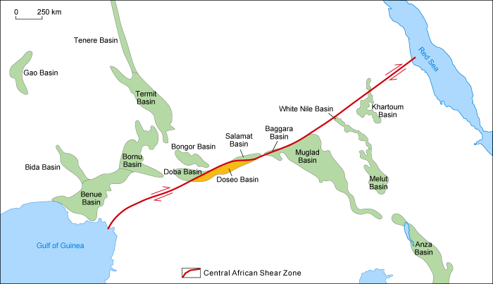
The Doseo Basin is located in the middle section of the CASZ with a width of 70-100 km and a length of 550 km, covering an area of about 4.5 × 10⁴ km2. Prior to 2009, there had been little research on the petroleum geology of the basin, and the most recent study had been carried out in the 1990s [2-3]. Previous studies found that there are few Upper Cretaceous strata in the Doseo Basin, resulting in a lack of regional caprocks[2,5]. The Lower Cretaceous is predominantly mudstone and lacks effective reservoirs, which is quite different from the Doba Basin[6⇓⇓⇓⇓-11]. Consequently, it was concluded that there is little hydrocarbon potential in the Doseo Basin. In 2007, the China National Petroleum Corporation (CNPC) obtained a wholly- owned operating right for the exploration and development of Permit H in Chad. Then CNPC gave priority to exploration and development in the Bongor Basin [12]. After putting oilfields in the Bongor Basin into business development in 2011, CNPC shifted to the West Doba and Doseo basins for petroleum exploration and research. In 2014, Well Ximenia-1 was drilled in the Doseo Basin, and high-yield oil flows were obtained, which marked the beginning of petroleum exploration in the basin. Since then, a number of hydrocarbon-bearing structures were identified in the east of the block, breaking through the previous understandings that no effective caprocks and reservoirs developed in this area, and proved the exploration potential in the basin. Based on historical and new seismic and drilling data, this paper reexamines the petroleum geological characteristics of the Doseo Basin and, drawing on exploration practice in the area, analyzes its hydrocarbon accumulation conditions and enrichment pattern to offer new directions for the next phase of exploration throughout the Central African Rift System (CARS).
2. Tectonic characteristics
The Doseo Basin is a Meso-Cenozoic inverted rift basin covering on the Precambrian crystalline basement [2,8,13]. Its evolution history includes early strike-slip-extension and later tectonic inversion during the Meso-Cenozoic[9⇓⇓⇓⇓⇓⇓⇓-17]. A strike-slip displacement of 40-50 km followed by later inversion made the basin structurally and sedimentary complex [2,18].
The Doseo Basin is narrowly elongated in the NEE-SWW direction and is composed of half-grabens and grabens, faulted in north and overlapped in south as a whole. The Central Uplift consists of four highs: the Western High, the Middle High, the Kedeni High, and the K South High, which divide the basin into the Southern Depression Zone and the Northern Depression Zone. Structurally, the Northern Depression Zone is faulted in north and south, while the Southern Slope Zone, situated on the southern edge of the Southern Depression Zone, is faulted in north but overlapped in south (Figs. 2 and 3)[5,19].
Fig. 2.
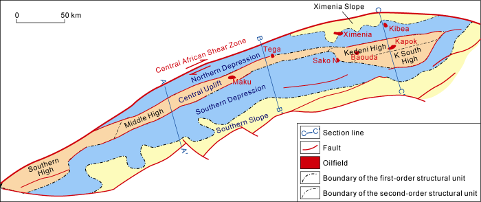
Fig. 2.
Division of structural units in the Doseo Basin.
Fig. 3.
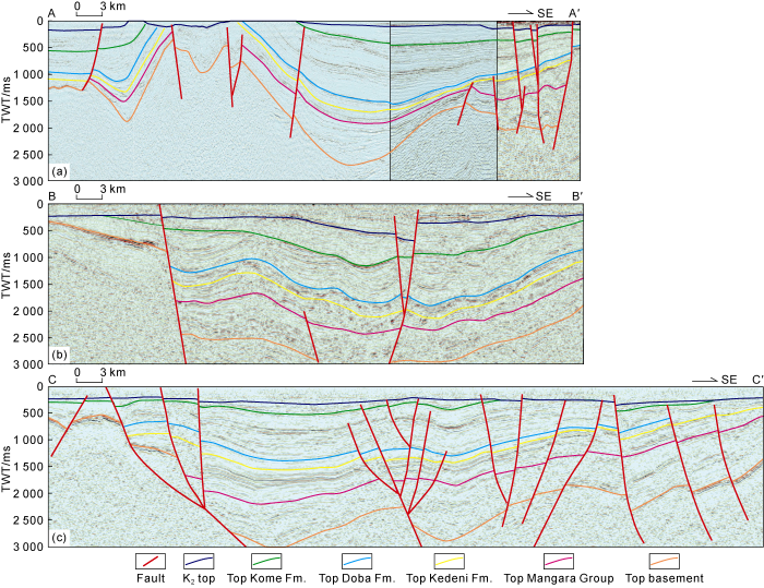
Fig. 3.
Regional seismic profiles of the Doseo Basin (see
The Doseo Basin underwent three phases of rift development, i.e., intensive strike-slip and extension in the Early Cretaceous, weaker extension in the Late Cretaceous, minor extension and then sagging in the Paleogene [20⇓⇓⇓⇓-25]. Two large structural layers are distinguished on the regional seismic profile. The lower structural layer is the Cretaceous strata, which are more than 8000 m thick at their maximum, extending from the basement to an overlying regional unconformity. The whole strata are uniformly compressed and deformed, forming a concentric compression anticline on the hanging wall of the boundary fault. The top of the strata, under the unconformity in the gentle slope zone, is eroded. Overall, the basin shrank about 10%-27% from its original size. An unconformity is locally developed at the top of the Lower Cretaceous Mangara Group in the lower structural layer, and the effect of the Santonian compression and inversion event discussed previously is not significant [22-23,25]. Intensive inversion and denudation occurred in the basin during the Late Paleogene. Seismic stratigraphic correlation shows that the eroded thickness of the basin reached 800-1000 m at about 40 Ma, which is close to the eroded thickness of the Bongor Basin (the result of extensive uplift) [22]. The upper structural layer is the Cenozoic formations above the regional unconformity. It is thin as well as loose and weakly controlled by the boundary fault across the whole area. There is also a regional parallel unconformity in the upper structural layer. Impacted by successive activities from the boundary fault, the lower strata have the maximum thickness (50-200 m) at the downthrow wall of the boundary fault, while the upper strata are 0-150 m thick and distributed throughout the basin.
3. Stratigraphic and sedimentary characteristics
3.1. Stratigraphic characteristics
There are three sets of sedimentary strata in the Doseo Basin, including the Lower Cretaceous, the Upper Cretaceous and the Cenozoic[26]. Sedimentation predominantly occurred during the Early Cretaceous period. Although the basement has not been drilled yet, it can be inferred that it is the crystalline basement of Gondwana formed during the Pan-African Movement, and similar to other rift basins in the Western and Central Africa Rift System[5] (Fig. 4). Paleontological analysis of sporopollen and ostracod in Well kapok-1 (1265-2915 m) shows that the strata are mainly the lower Cretaceous, and the discovery of Dinoflagellate and Cypridea indicates that the sedimentary environment is fresh-brackish water. The Lower Cretaceous is divided into two cycles, including the Mangara Group, the Kedeni, Doba and Koumra formations from bottom up. The Mangara Group was formed during a complete transgressive-regressive cycle in the early stage of rifting, with 1-3 km thick lacustrine delta sand and mud deposits. The upper sand-to-formation ratio is about 45%-60%, whereas the lower part has not been drilled yet. The kedeni, Doba and Koumra formations were deposited in the transgressive-regressive cycle in the stable stage of rifting. The kedeni Formation is lacustrine mudstone intercalated with braided-delta or fan-delta sandstone in a lowstand-transgressive system tract, with a thickness of 600-1200 m. The sand-to-formation ratio of the upper member is about 40%-55%, and that of the lower member is about 30%-45%. The Doba and Koumra formations are lacustrine-fluvial-delta sandstone and mudstone in a highstand systems tract. The thickness of the Doba Formation is 400-700 m, and the sand-to-formation ratio is about 20%-35%. The thickness of the Koumra Formation is 300-600 m, and the sand-to-formation ratio is about 45%-60%. The strata of the late Cretaceous were of fluvial-lacustrine sediments, with a thickness of 500-1100 m and the sand-to-formation ratio about 55%-70%. The Kome Formation, mainly lacustrine-delta sandstone, is located in the lower part of the upper cretaceous. The sedimentary environment during the Paleogene was shore-shallow lacustrine delta, and later gradually became shore-shallow lake as well as alluvial plain in the Neogene. The Neogene sandy deposits are weakly consolidated, with a residual thickness of 250-450 m.
Fig. 4.
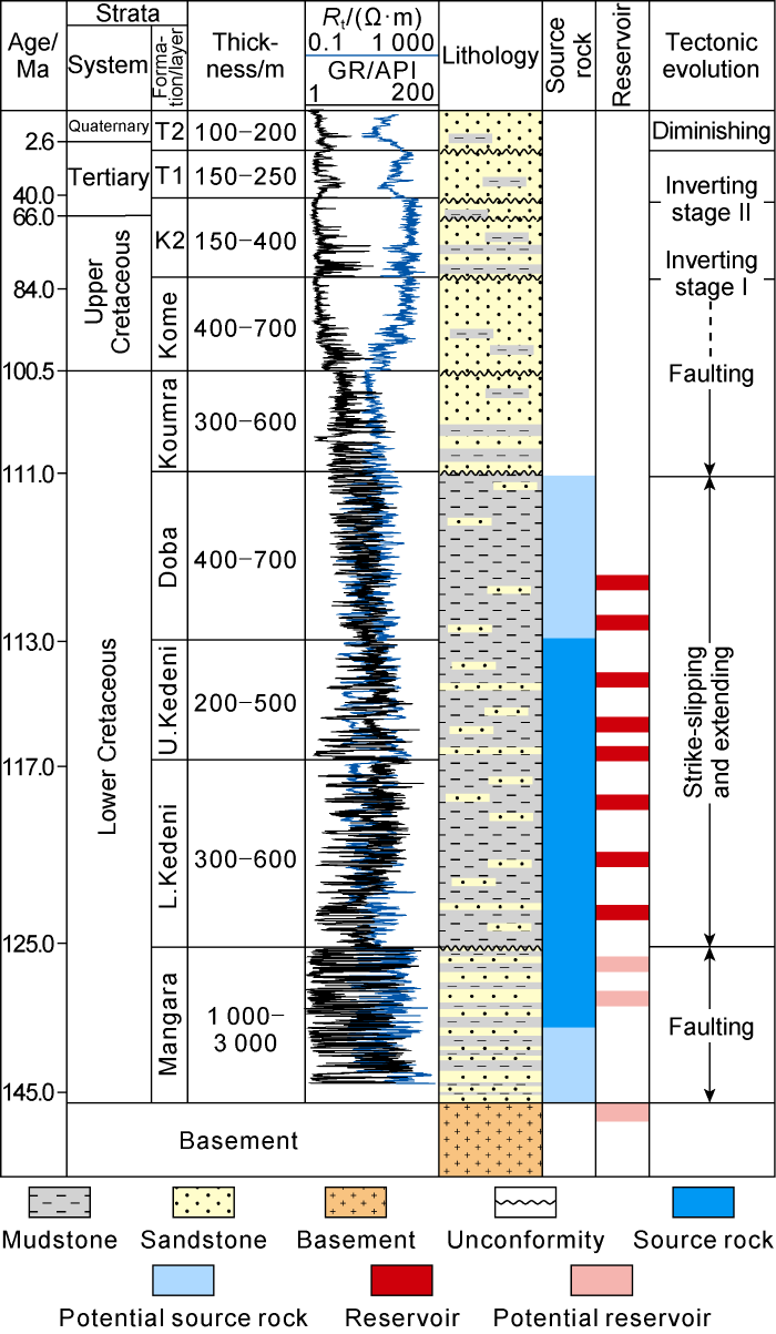
Fig. 4.
Composite stratigraphic column of the Doseo Basin. Rt—resistivity; GR—natural gamma.
Rt—resistivity; GR—natural gamma.
3.2. Sedimentary characteristics
The sedimentary evolution of the Doseo Basin corresponds to the tectonic evolution of the basin. The lower Early Cretaceous demonstrates a transgressive cycle in the rifting stage, while the upper Early Cretaceous to the Late Cretaceous reflects an aggradation-regressive cycle in the depression stage. The upper Late Cretaceous to the Paleocene is a compressing-inverting stage when the basin was uplifted and denuded. The Cenozoic is the basin’s diminishing period when the sedimentation of fluvial-alluvial plain was developed [26-27]. The Early Cretaceous witnessed the formation of a rifting lacustrine basin where well-sorted medium-fine grained quartz sand bodies of delta and fan-delta deposits, whose provenance was relatively far and were developed in the northern and southern depressions, respectively. The southern margin is dominated by delta and braided-delta deposits which forms the sandbodies in large scale and extends farther into the basin. Meanwhile, the northern margin received sediments from fan delta or braided delta. The sand bodies of the northern margin are smaller in size than that of the southern margin, but the thickness of the northern single sand body is larger. The depression center contains semi-deep-lacustrine and deep-lacustrine mudstone, intercalated with a few turbidite sandstone and distal-bar sandstones (Fig. 5). The early stage of the Early Cretaceous is a retrograde cycle when the lacustrine basin expanded and deepened. Then, in the middle stage of the Early Cretaceous, delta sand bodies accumulated, and formed the primary oil reservoir system. Finally, in the late stage of the Early Cretaceous, sandstone became thicker and coarser as sand bodies prograde.
Fig. 5.
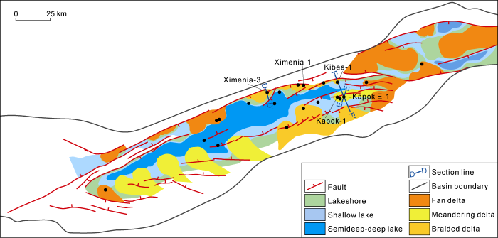
Fig. 5.
Sedimentary facies of the Lower Cretaceous in the Doseo Basin.
4. Petroleum system
4.1. Source rock
The Lower Cretaceous of the Doseo Basin contains many sets of lacustrine source rocks. All of the Doba Formation, Kedeni Formation and Mangara Group consist of high-quality source rocks, which gradually transition into strata with high sand content at the edge of the depression[28⇓⇓-31]. The thickness of the source rocks varies greatly in the basin. In the center of the depression, the source rock of the Doba Formation and Kedeni Formation could reach 400 m and 800 m thick, respectively. The source rock of the Mangara Group is more than 500 m thick estimated by seismic data, although it hasn’t been drilled through in the center of the depression. The systematic analysis data of mudstone cuttings drilled in Well Ximenia-1 and Well Kapok-1 (Table 1) shows that the mudstone in the Kedeni Formation is preferable due to its abundance in organic materials with average TOC of 3.8% and average HI of 760 mg/g, therefore, becoming the primary source rock in the Doseo Basin. The source rock in Doba Formation contains types II2-II1 of organic matters, while those source rocks in Kedeni and Mangara groups are type I organic matter. In general, these source rocks mainly generate oil (Fig. 6).
Fig. 6.
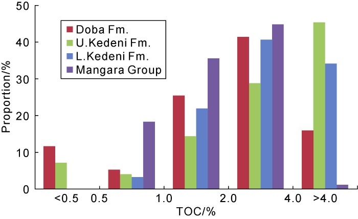
Fig. 6.
TOC distribution of source rocks in the Doseo Basin.
Table 1. Characteristics of source rocks from wells drilled in the Doseo Basin
| Formation | Dark mudstone thickness/m | Mud-to-formation ratio/% | Average TOC/% | Average S1+S2/(mg·g-1) | Average HI/(mg·g-1) | R0/% (Single well regression data) |
|---|---|---|---|---|---|---|
| Doba Fm. | 400 | 70 | 2.9 | 19 | 524 | 0.45-0.75 |
| Kedeni Fm. | 800 | 60 | 3.8 | 32 | 760 | 0.75-1.20 |
| Mangara Group | >165 | 50 | 2.0 | 10 | 454 | 1.2-2.0 |
Note: TOC represents total organic carbon; S1+S2 represents hydrocarbon generation potential; HI represents hydrogen index.
On the plane, the maturity of the source rocks in the depocenter of the northern depression is the highest. Specifically, the source rock of the Doba Formation is from low mature to mature, that of the Kedeni Formation is from mature to high mature, and that of the Mangara Group is in high mature to gas generating stage. The maturity of the source rocks gradually decreases from the depocenter to the edge of the basin. In Well Kapok-1 drilled in the central low uplift belt in the east of the basin, only the source rocks of the Kedeni Formation and the drilled Mangara Group are mature. The current geothermal gradient of the basin is 30 °C/km, calculated from the geothermal data of drill stem test, while the paleogeothermal gradient calculated from apatite fission track and vitrinite reflectance is only 20 °C/km. At present, the threshold depth of oil generation is 1800-2200 m. According to the oil source correlation, crude oil and source rocks discovered so far are all within the oil-generating window (Fig. 7), but the maturity of the crude oil, disclosed by the biomarker parameters, is higher than that of the source rocks drilled. Thus, it is inferred that the crude oil currently discovered may migrate from the deeper source rocks that have not been drilled in the depression[17].
Fig. 7.
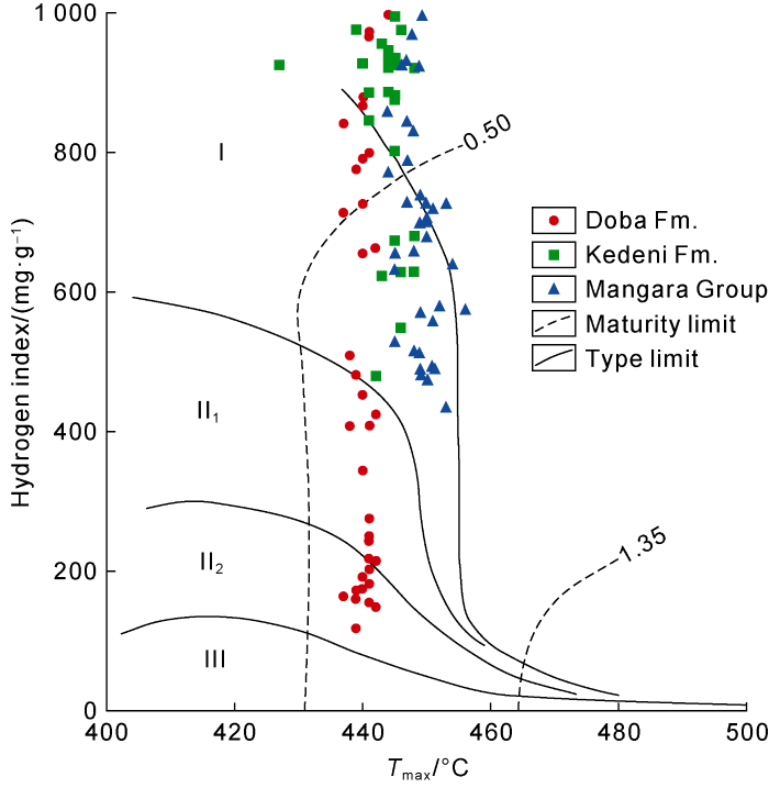
Fig. 7.
Types of organic matter of source rocks in the Doseo Basin.
4.2. Reservoirs
Many sets of sandstones identified in the lacustrine- delta system of the Doba Formation, Kedeni Formation and Mangara Group could be the effective reservoirs in the Doseo Basin. At present, most of the reserves are found in the sandstone of the Kedeni Formation, at a depth ranging from 1500 to 3000 m. The sedimentary environment is mainly braided or meandering-river delta, and sediments are fine sandstone and siltstone, of which, the quartz sandstone and feldspathic quartz sandstone are dominant, with variable feldspar and detritus content (Fig. 8). Primary intergranular pores and secondary dissolution pores dominate the reservoir space in the Kedeni Formation in the east and south of the basin. The porosity of the primary reservoir of the Lower Cretaceous is 11%- 16% and the permeability is (80-2000)×10-3 μm2, indicating the reservoir is of medium porosity and medium-high per-meability. There is a strong positive correlation between porosity and permeability. The diagenesis of the Kedeni sandstones observed is in the late stage of early-diagenesis, mainly compaction and cementation. The sandstone of the Kedeni Formation near the depocenter of each depression is buried deeply and reaches the early stage of meso-diagenesis. The grains are in point-line contact. Apart from that, ankerite and secondary overgrowth of quartz can be observed. Smectite accounts for 10%- 30% in the illite/smectite mixed layer, and its Ro value is 0.9%-1.0%. In the northern slope, the Kedeni Formation is mainly comprised of fan delta sandstone, with poorly sorted reservoirs, low structural maturity and high content of feldspar and detritus. Although feldspar and some other grains are easy to dissolve, the dissolved pores are easy to be filled with minerals such as calcite and kaolinite, resulting in low porosity and poor pore connectivity.
Fig. 8.
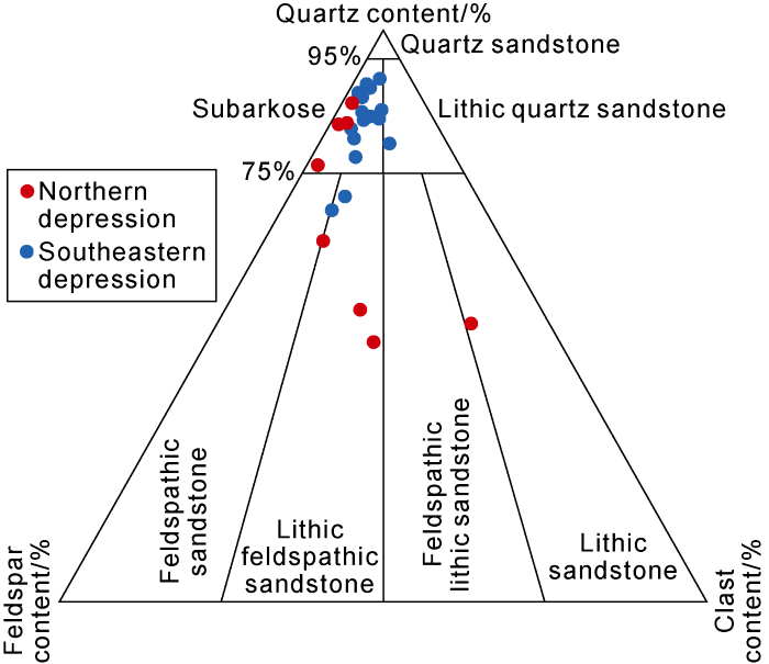
Fig. 8.
Types of reservoir rocks of the Kedeni Formation in the Doseo Basin.
The buried depth of the reservoirs of the Doba Formation is relatively shallow, leading to the weak compaction and abundant primary pores. Due to these reasons, the physical properties of the reservoirs in the Doba Formation are better than those in the Kedeni Formation, although both formations have similar lithology. Reservoirs in the Mangara Group are mostly concentrated in the upper part. They are mainly medium-grained sandstone experiencing strong compaction, so the physical properties are worse than that of the Kedeni Formation.
4.3. Play
The Upper Cretaceous in the Doseo Basin is dominated by sandstone and lacks effective regional caprock. The reservoirs discovered currently are almost in the Lower Cretaceous. The Doba Formation of the Lower Cretaceous in the central and northern basin is the widely distributed pure mudstone, with a thickness of hundreds of meters. In the eastern and southern edges of the basin, sand-mud interbeds appear, and their sealing capacity gradually becomes poor. Therefore, only small-size oil and gas reservoirs may exist in the Doba Formation. Dark mudstone in the Kedeni Formation could be the regional caprock, as it is thick, and locally undercompaction as well as abnormal high pressure. In the east of the basin, thick and stable mudstone is also found in the Kedeni Formation, while in the north of the basin, the ratio of mud to formation of the Kedeni Formation is as high as 80%, and the thickness of a single mudstone layer may reach 100 m. Apart from this, the thickness of a mudstone layer in the southeast of the basin and other areas close to the edge, can still reach 10-40 m, resulting in the Kedeni Formation as an important regional caprock. Based on drilling data, the mudstone layer in the upper member of the Mangara Group is relatively thin, only acting as a local caprock.
Corresponding to the Doba Formation, Kedeni Formation and Mangara Group, there are also three sets of plays located in the upper, middle and lower parts of the Doseo Basin, respectively. Considering that the Kedeni Formation and Mangara Group are major source rocks, and the mudstone in the Kedeni Formation is the most stable, the play in the Kedeni Formation is the main play in the basin. The Mangara Group in the center of the basin is buried too deep, resulting in poor reservoir conditions. The Manara play may be effective in the area close to the edge of the basin, dominated by self-generation and self-storage reservoir. Controlled by caprock conditions, the play in the Doba Formation is mainly formed near the center of the basin, with a lower-generation and upper-storage pattern.
5. Oil and gas accumulation play
The Doseo Basin is predominantly featured of normal and strike-slip faults, with reverse faults occurring locally due to the later inversion. Various structures, including typical negative flower structures, compressional anticlines, fault noses, complex fault blocks, etc., have contributed to diverse types of structural traps and created favorable conditions for oil and gas accumulation. There have been sporadic discoveries of oil reservoirs in the Doseo Basin since 1978, but there were no major breakthrough until recently. The oil and gas discoveries made so far are mainly concentrated in the northeast of the basin operated by CNPC, where exploration has been most intensive. Most of these discoveries combine the features of anticline or fault-anticline oil reservoirs. There are multiple sets of oil-water systems and large-span oil-gas layers, but the height of the oil and gas column is mostly less than 100 m.
5.1. Hydrocarbon accumulation zones in steep slopes
The intense tectonic inversion in the Pyrenean event produced a series of anticline and faulted-anticline structural traps along the depression-controlling fault zone in the steep slope of the Doseo Basin. These traps are close to not only the hydrocarbon generation center but the transporting fault, and represent a highly favorable area for oil and gas migration. The Lower Cretaceous reservoir in the steep slope zone of the Doseo Basin consists mainly of fan-delta sand bodies, accompanied by gravity flow deposits. However, the reservoir conditions and transverse continuity are unstable. Thus, the reservoir conditions have become the main controlling factor for oil and gas accumulation in this favorable play. Apart from that, hydrocarbons have been obtained in 4 completed wells. Most of the oil layers are in the Kedeni Formation, and a few in the Doba Formation. The depth of the oil layers is mainly distributed between 1200 and 2600 m. The Kedeni Formation contains mainly normal crude oil (with relative density 0.71-0.92) with less gas. The relative density of the crude oil in the Doba Formation is 0.96 (Fig. 9).
Fig. 9.
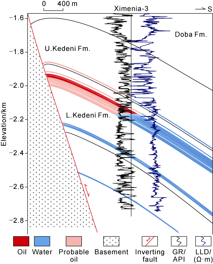
Fig. 9.
Typical oil reservoir profile in the Northern Steep Slope.
5.2. Hydrocarbon accumulation zones in the Central Low Uplift
Formation of the Central Uplift/Highs in the east of the depression is related to the strike-slip that occurred in the late Early Cretaceous. Later, it experienced a certain degree of inversion and compression, which led to reformation of the original structure and the development of a series of fault-block, fault-nose and faulted-anticline traps (Fig. 10). Several oil reservoirs with a wide range of areas horizontally have been found in the Kedeni Formation. Oil and gas migration in the basin is generally towards the Central Low Uplift. Moreover close to the long axis of the provenance area on the east side, a relatively stable braided river delta was found with good reservoir conditions. Lacustrine mudstone deposited and lithified during successive transgression period provided superior caprocks in this area. Because of the superposition of multi-stage tectonic movements, a large number of faults have been produced. In addition, there is almost no unified oil/water contact (OWC) between oil reservoirs, so the relationship between oil and water is complex. Hydrocarbon accumulation in the area is strongly controlled by the fault-caprock combination. It has been found that oil layers in Kapok Oilfield are chiefly in the Kedeni Formation, and only a few in the Doba Formation and the Mangara Group. The oil layers are 1400-2700 m deep. The Kedeni Formation and the Mangara Group contain mainly normal crude oil (with relative density 0.79-0.90), with few gas. The relative density of the crude oil in the Doba Formation is 0.95.
Fig. 10.
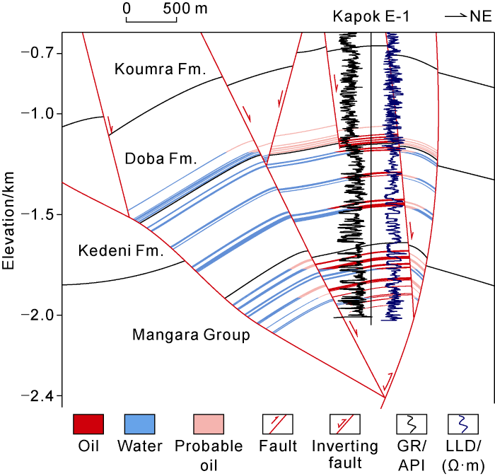
Fig. 10.
Typical oil reservoir profile in the Central Low Uplift.
5.3. Potential hydrocarbon accumulation zones in gentle slopes
A series of fault nose and fault block traps are recognized in the Southern Gentle Slope Zone of the Doseo Basin, and offer favorable hydrocarbon migration conditions. However, the ratio of sand to formation gradually increases, and both the quality and maturity of the source rocks deteriorate in this area[19]. For those reasons, the factors including oil source and caprock conditions play an important role in oil and gas accumulation. Based on the source rock and lithology conditions in the adjacent Mangara Group, it can be reasonably inferred that the trap in the Lower Mangara Group is advantageous for the formation of the self-generation and self-storage reservoir. To date, a little exploration has been carried out in this area, and there is only an old well producing a large amount of dead oil. This discovery may suggest a play with a good potential of oil and gas accumulation in the Southern Gentle Slope Zone.
In conclusion, controlled by the structural characteristics and oil and gas accumulation conditions, there are some differences among various zones in the Doseo Basin. The hydrocarbon enrichment is the greatest in the Central Low Uplift Zone, where faulted anticline and fault block traps exist in large quantities. This is followed by the steep slope zone, where anticline and faulted anticline traps can be found. The Southern Gentle Slope Zone is another potential enrichment zone where oil and gas laterally migrate to fault nose and fault block traps, with faults and caprock acting as lateral and top seals to prevent the hydrocarbon from escaping (Fig. 11).
Fig. 11.
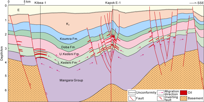
Fig. 11.
Hydrocarbon accumulation model of the Doseo Basin.
6. Conclusions
The Doseo Basin experienced intense strike-slip extension in the Early Cretaceous, weak extension from the Late Cretaceous to the Paleocene and compressional inversion as well as denudation in the Eocene (about 40 Ma). Rifting activities were not significant in the Paleogene. Three sets of strata, the Lower Cretaceous, the Upper Cretaceous and the Cenozoic, were found in the basin. The Lower Cretaceous is mainly comprised of lacustrine-braided delta or fan delta sediments.
The Lower Cretaceous contains deep lacustrine mudstone. Meanwhile, the organic matters are type I and type II1 kerogen with high to extremely high abundance. Furthermore the depth ranging from 1800 to 2200 m is the current hydrocarbon generation threshold of the source rock. The maturity of the crude oil in the discovered reservoirs is higher than that of the source rocks drilled, suggesting that the source rocks of the current-discovered reservoirs are in the deep depressions and has not been drilled.
Braided-river delta sandstones of the Kedeni Formation distributed in the east and south of the depression could form high-quality reservoirs, so it is expected that the play in the Kedeni formation is the most important play with the highest abundance of hydrocarbon resources in the basin.
Two hydrocarbon accumulation zones have been discovered in the Doseo Basin. Firstly, the northern steep slope is dominated by anticline/fault anticline traps, where the controlling factor on hydrocarbon accumulation is the reservoir condition. Secondly, the central low uplift has fault block/fault anticline as favorable structural traps, where the hydrocarbon accumulation is attributed to the fault-caprock relationship. Lastly, a potential hydrocarbon accumulation zone has been recognized at the southern gentle slope zone where the hydrocarbon accumulation is mainly dependent on the conditions of oil source and caprock, and the play of the Mangara Group is a potential exploration target.
Reference
The geodynamic setting of the Phanerozoic basins of Africa
DOI:10.1016/j.jafrearsci.2005.07.016 URL [Cited within: 1]
Petroleum geology of Cretaceous-Tertiary rift basins in Niger, Chad, and Central African Republic
Exploration, production, and midstream information
https://my.ihs.com/Energy IHS.
Regional framework, structural and petroleum aspects of rift basins in Niger, Chad and the Central African Republic (C.A.R.)
DOI:10.1016/0040-1951(92)90257-7 URL [Cited within: 1]
Phanerozoic geological evolution of Northern and Central Africa: An overview
DOI:10.1016/j.jafrearsci.2005.07.017 URL [Cited within: 3]
Senonian basin inversion and rejuvenation of rifting in Africa and Arabia: Synthesis and implications to plate-scale tectonics
DOI:10.1016/S0040-1951(97)00212-6 URL [Cited within: 1]
Climatic controls on depositional setting and alluvial architecture, Doba Basin, Chad: BAGANZ O W, BARTOV Y, BOHACS K M, et al. AAPG Memoir 95: Lacustrine Sandstone Reservoirs and Hydrocarbon Systems
Early Cretaceous rifts of Western and Central Africa: An overview
DOI:10.1016/0040-1951(92)90256-6 URL [Cited within: 2]
Genetic mechanisms and tectonic types of petroliferous basins in the Central Africa Shear Zone
Hydrocarbon formation and distribution of rift basins in Sudan-A comparative analysis of them with rift basins in East China
Petroleum geology and a model of hydrocarbon accumulations in the Bongor Basin, the Republic of Chad
Dynamic mechanism of rift systems in West and Central Africa
Types and hydrocarbon accumulation characteristics of rift basins in Africa
Discussion on the structural features and formation mechanism of strike-slip pull-apart basin: A case study in the Doseo Basin, Central Africa
Source rocks evaluation and oil-source correlation of the Doseo Basin, Chad
Biogeochemistry of stable carbon isotopes:EGLINTON G, MURPHY M T J. Organic Geochemistry
Phanerozoic evolution of plants on the African plate
DOI:10.1016/j.jafrearsci.2005.07.015 URL [Cited within: 2]
The role that plate tectonics, inferred stress changes and stratigraphic unconformities have on the evolution of the West and Central African Rift System and the Atlantic continental margins
DOI:10.1016/j.tecto.2013.03.021 URL [Cited within: 1]
Tectonic evolution of the Doba and Doseo basins, Chad: Controls on trap formation and depositional setting of the three fields area, Chad
Thermal history reconstruction from apatite fission-track analysis and vitrinite reflectance data of the Bongor Basin, the Republic of Chad
DOI:10.1306/11182019167 URL [Cited within: 3]
Central African Rift System: Qualitative evaluation:AAPG International Conference and Exhibition 2008
Inversion tectonics in Central Africa Rift System: Evidence from the Heglig Field
DOI:10.1016/j.marpetgeo.2016.12.007 URL [Cited within: 1]
Origin and growth mechanisms of strike-slip faults in the central Tarim cratonic basin, NW China
Impact of inversion tectonics on hydrocarbon entrapment in the Baggara Basin, western Sudan
Factors controlling the development of tight sandstone reservoirs in the Huagang Formation of the central inverted structural belt in Xihu sag, East China Sea Basin
Lacustrine environment reservoir properties on sandstone minerals and hydrocarbon content:A case study on Doba Basin, southern Chad
Organic geochemical characteristics of Lower Cretaceous source rocks and crude oils in Doseo Depression of Central African Rift System
DOI:10.1016/j.jafrearsci.2021.104118 URL [Cited within: 1]
Suppression of vitrinite reflectance in amorphous rich kerogen-A major unrecognized problem
DOI:10.1111/j.1747-5457.1985.tb00191.x URL [Cited within: 1]
Guidelines for evaluating petroleum source rock using programmed pyrolysis
