


Introduction
The Songliao Basin is a continental sedimentary basin with abundant oil and gas resources[1,2]. The Daqing exploration area located in the north of the basin is about 120 000 km2, where the largest continental sandstone oilfield in the world, Daqing Oilfield, has been discovered. The west of Daqing Placanticline (hereinafter referred to as the west slope) is a broad slope. It is a gentle slope zone formed in a huge lake basin in history. The west slope is adjacent to Qijia-Gulong hydrocarbon generation sags, and mainly includes the west of the central axis of Qijia-Gulong sag, Longhupao - Da’an terrace, Taikang uplift belt and western overlapping zone. It is an important site for hydrocarbon accumulation with an exploration area of about 16 500 km2 (Fig. 1). Since the 1960s, oil and gas exploration in the west slope has undergone three phases: structural reservoir, lithologic-structural reservoir, and structural-lithologic reservoir. The target layers are Cretaceous Putaohua oil layer, Sartu oil layer, Gaotaizi oil layer and Fuyu oil layer (Fig. 2), and Aogula, Longhupao, Halwin, Longnan, Fularji, Talahong, Yixin, Talagha and other oil and gas fields have been discovered successively[3,4,5,6,7,8,9,10]. According to the results of the 4th round of oil and gas resources evaluation, the petroleum geological resources of the west slope are nearly 21×108 t. Up to now, the west slope has proved, probable and possible reserves of 5×10⁸ t in total discovered, 16×108 t of remaining resources and great exploration potential. At present, composite reservoir in the slope area has become an important target for fine exploration. According to the match relationship between hydrocarbon reservoirs and source rocks, the west slope has reservoirs both in and out of the source rock. The scale of hydrocarbon reservoir is in positive correlation with the distance from mature source rock. A large number of studies have been conducted on reservoir formation characteristics and main controlling factors in the slope zone[3,4,5,6,7,8,9,10,11,12,13,14,15,16,17,18,19], which mainly focused on the control effect of reservoir types on hydrocarbon accumulation and distribu-tion[7,8,9,10]. Hydrocarbon sources[3,4] and accumulation stages[5,6] have also been studied, but mainly focusing on the control effect of individual factors on oil and gas accumulation. In this study, the accumulation characteristics and main controlling factors in upper and lower slopes have been analyzed to find out the distribution pattern of oil and gas reservoirs. As the remaining resources are largely in composite reservoirs, a set of fine exploration methods has been developed which can guide the oil exploration of the middle and shallow layer in the northern Songliao Basin.
Fig. 1.

Fig. 1.
Division of structural units in the northern Songliao Basin.
Fig. 2.

Fig. 2.
Composite columnar section of middle and shallow formations in northern Songliao Basin.
1. Structural and sedimentary characteristics of the west slope
1.1. Structural features
The Songliao Basin has a typical dual-structure. In the lower fault depression stage, the Cretaceous Huoshiling, Shahezi and Yingcheng formations developed where gas is the main exploration target. In the upper depression, the 3rd-4th members of Cretaceous Quantou Formation, Qingshankou Formation, Yaojia Formation and Nenjiang Formation developed, where oil is the main exploration target. In history, west slope has been a monocline tilting from the western edge of the basin to the central depression with few faults and flat structure[14,15,16,17]. According to structural features and development of hydrocarbon source rock, west slope can be divided into the upper slope and lower slope. The lower slope is located in the range of mature hydrocarbon source rock, steep in structure, with slopes generally less than 10°. It includes the west part of the central axis of Qijia-Gulong sag, and Longhupao - Da’an terrace. The upper slope is out of the range of the mature hydrocarbon source rock, is flatter in structure, with a slope of generally less than 2°, and mainly includes the Taikang uplift belt and the western overlap belt (Figs. 3 and 4). Due to different stresses at different tectonic locations, different parts in the west slope have different structural morphology and fault distribution. Fine interpretation of regional major profile shows (Fig. 3) from east to west the west slope has north-south strike Longhupao anticline, north-east strike Baiyinnuole nose structure, Alaxin nose structure, Erzhan nose structure, Jiangqiao nose structure and west overlap zone. The reservoirs discovered so far are mainly distributed in these structural belts above (Fig. 4).
Fig. 3.
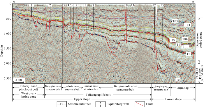
Fig. 3.
Seismic profile of the west slope in the northern Songliao Basin (Location is shown in
Fig. 4.
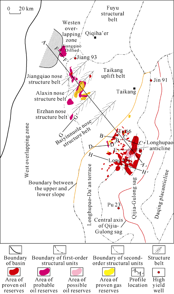
Fig. 4.
Structural units and oil and gas of west slope in the northern Songliao Basin.
According to the "Petroleum geology of China"[20], the basin began reverse deformation, folding and fault activities under compression at the end of the Nenjiang Formation period. The basin continued compressive activities at the end of the Mingshui Formation period. Both of them are major tectonic activity periods. At the end of the Nenjiang Formation period, the Aogula nose structure and Longhupao structure in the lower slope took shape initially. At the end of the Mingshui Formation period, the slope increased obviously and the Aogula nose structure and Longhupao structure finalized. At the end of the Yi 'an Formation period, the structural pattern of alternate sags and uplifts in this area fixed, forming north- east spreading Longhupao anticline and Aogula fault zone. At the end of Nenjiang Formation period, the upper slope had structural differentiation under the action of near south-north regional compression, giving rise to four north-east spreading wide and gentle nose-like structural belts, Baiyinnuoler, Erzhan, Alaxin and Jiangqiao, along with the formation of faults.
These shallow positive structures have a good correspondence with deep fault depressions, and most of the middle and shallow structures are formed on the basis of activities of faults controlling early fault depression. The deep-faults controlling fault depressions were active during the tectonic inversion period, controlling the formation and distribution of nose structures (Fig. 3). From the perspective of match relationship between structure formation and reservoir formation, the structure belts in the west slope were formed slightly earlier than or at the same time with the large-scale hydrocarbon migration and accumulation[18]. The tectonic movements after the deposition of Nenjiang Formation directly affected hydrocarbon migration and accumulation in the transport layer from high potential area to low potential area.
1.2. Sedimentary features
The exploration target layers in the west slope are Putaohua oil layer in 1st member of Yaojia Formation, Sartu oil layer in 2nd-3rd members of Yaojia Formation and 1st member of Nenjiang Formation. They have obvious differences in sedimentary characteristics.
In the depositional period of the 1st member of Yaojia Formation, the subsidence rate of the whole basin slowed down obviously, the base-level cycle of the basin was in the low system tract stage (Fig. 2), the surrounding clastic source supply was plentiful, and large shallow lake basin delta sedimentary systems developed, so the north Songliao Basin was characterized by “full of sand”, laying a solid foundation for sag-wide oil-bearing. The west slope was gentle in paleotopography, so sand bodies are widely distributed affected by sediments from north and west. The reservoir bodies are mainly distributary channel sand bodies, estuary bar sand bodies and sheet sand controlled by large shallow water delta. The 1st member of Yaojia Formation is missing in the upper slope because of uplift and erosion. The reservoirs are mainly distributed in the lower slope (Fig. 5a).
Fig. 5.
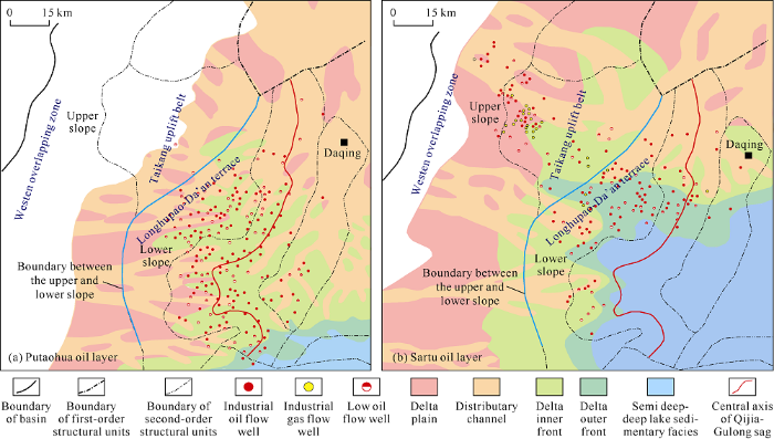
Fig. 5.
Sedimentary facies distribution of Putaohua oil layer (a) and Sartu oil layer (b) in the west slope of the northern Songliao Basin.
During the sedimentary period from 2nd-3rd members of Yaojia Formation to 1st member of Nenjiang Formation, the lake level rose rapidly and the base-level cycle of the basin was in the high system tract stage (Fig. 2). Most part of the basin was semi-deep to deep lake environment[21,22,23] and the north and west delta sedimentary systems developed. The sand bodies were mainly distributed in the margin of the lake basin like a "ring". Close to the provenance, the west slope had widespread sand bodies, which would be good hydrocarbon transport layers and reservoirs. In the upper slope, there developed mainly delta plain and delta inner front sand bodies with large thickness, good continuity, shallow burial and good physical properties. In the lower slope, delta inner front and delta outer front sand bodies are smaller in scale than those in the upper slope (Fig. 5b).
It is proved that hydrocarbon reservoirs are obviously controlled by sedimentary facies and industrial oil flow wells are mainly distributed in delta front subfacies (Fig. 5b). The sand bodies of delta facies widely developed in Longhupao terrace, Taikang uplift belt and west overlapping zone provide favorable space for hydrocarbon accumulation.
2. Accumulation and controlling factors
2.1. Accumulation
The slope area is a favorable direction for long-distance migration and accumulation of oil and gas. The oil-source correlation shows[3,4,6,24-26] that the oil and gas of the west slope mainly come from mature source rock of Qingshankou Formation in Qijia-Gulong sag on the east side. There are multiple types of reservoirs, such as structural reservoir, composite reservoir and lithologic reservoir. Under the influence of the spatial distribution of hydrocarbon source rocks and oil and gas reservoirs, the upper and lower slopes differ significantly in reservoir formation characteristics.
2.1.1. The lower slope
The lower slope from the west of the central axis of Qijia-Gulong sag to the inner boundary of mature source rock (Ro>0.75%) of Qingshankou Formation is located in the main hydrocarbon generation sag, with sufficient oil source. Under the buoyancy, oil and gas migrated along faults to Sartu, Putaohua and Gaotaizi oil layers in the upper part. At the same time, under the effect of hydrocarbon generation pressurization, hydrocarbons migrated along faults to the lower Fuyu oil layer and accumulated in fault-related structures or in lithologic composite traps. Therefore, Sartu oil layer, Putaohua oil layer, Gaotaizi oil layer and Fuyu oil layer of the lower slope are all full of oil but different oil layers have different reservoir types. Taking Sartu oil layer and Putaohua oil layer as examples, the accumulation characteristics were analyzed in this study. (Note: Gaotaizi oil layer and Fuyu oil layer are mainly shale oil and tight oil, which are not discussed in detail in this paper).
Sartu oil layer is mainly delta front sedimentary system, and the reservoir types are different affected by the development degree of sand body vertically. The sandstone layers of S2+3 and S1 oil layers are widely superimposed and connected, and contain mainly structural reservoirs. The S0 oil layer is composed of gravity fluvial deposits and has lithologic and structure-lithologic hydrocarbon reservoirs (Fig. 6a, 6b).
Fig. 6.
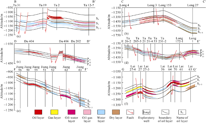
Fig. 6.
Reservoir section of the west slope in north Songliao Basin (the section location is shown in
Putaohua oil layer is mainly delta front sedimentary system, with sand bodies obviously larger than those of Sartu oil layer, but the sand bodies are poor in connectivity vertically and horizontally, therefore, large area lithologic reservoir and complex reservoir are more likely to occur. The whole Putaohua oil layer is contiguously filled with oil, mainly includes structure, structure-lithology, lithology and other types of oil and gas reservoirs (Fig. 6c, 6d).
2.1.2. The upper slope
The upper slope stretching from the outer boundary of mature source rock (Ro>0.75%) of Qingshankou Formation to the basin boundary has shallow buried depth, fewer faults and structural traps, where local source rocks are in immature to mature stage. At first, the oil and gas generated from the Qijia-Gulong sag of the lower slope migrated to Gaotaizi oil layer inside the source area and then migrated to the west along faults, unconformities and sand bodies. At last, hydrocarbon accumulated in Sartu oil layer to form reservoirs (there is no Putaohua oil layer in this area). Although there are reservoirs in the lower Gaotaizi and Fuyu oil layers, the source rock of Qingshankou Formation in this area is poor, so Gaotaizi and Fuyu oil layers in this area are not good because of the lack of high driving force for hydrocarbon to migrate downward. The study shows that the effective traps on the migration path are likely to form reservoirs during the large-scale and long-distance hydrocarbon migration. Migration direction and path of crude oil on the west slope have been proved by changes in contents of carbazole nitrogen-containing compounds[27]. The Fularji oilfield is over 100 km away from the mature source rock area of Qijia-Gulong sag, which further proves that the west slope has the conditions for long-distance migration and accumulation of oil and gas. The oil and gas in the upper slope are mainly distributed in a series of NE nose-shaped structural zones and stratigraphic overlapping zones (Fig. 4). The main part of the nose like structural belt has structure, structure-lithology hydrocarbon reservoirs; whereas the wing and overlapping zone of the structural belt have stratigraphic overlap and updip pinch-out lithologic hydrocarbon reservoirs (Fig. 6e, 6f).
2.2. Main controlling factors of accumulation
Controlled by source rock, structure, fault, sand body and migration, different types of hydrocarbon reservoirs are formed in the upper and lower slopes respectively, which are different in main controlling factors. According to match relationship of structural style, fault and sand body, 4 sub-types of 3 hydrocarbon reservoir types have been identified by analyzing the types of hydrocarbon reservoirs and main controlling factors of reservoir formation in detail, namely, structural trap + favorable sand body, structure or fault + favorable sand body and lithology (Fig. 7). TypeⅠis the match of structural trap and favorable sand body, which refers to the accumulation by the matching of structural traps on anticline belt, nose like structural belt and fault belt and favorable sand bodies. This kind of accumulation is mainly controlled by structure. TypeⅡ contains two sub-types, which are the match of tectonic background or fault and favorable sand body. Tectonic background + sand body sub-type means that there is a certain scale of structural form but no obvious structural trap on the main body of the fault structural belt, and composite traps are formed by the sand body cutting the structure. For example, the long axes of Jiangqiao, Alaxin, Erzhan and Baiyinnuoler nose-like structure are in the NNE direction, which almost perpendicularly intersects with distribution of channel sand bodies, so many complex reservoirs with large tectonic amplitude are formed. These reservoirs are controlled by structure and lithology jointly, but by structure primarily. Fault + sand body sub-type refers to the north - west sand bodies cut by north - east faults to form complex traps at the fault structural belts and slope. This type of accumulation is controlled by fault and lithology. Type Ⅲ reservoirs are distributed in the slope area between the overlap belt and structural belt, where channel sand bodies and stratigraphic pinchout lines are parallel, and the sand bodies pinch out in the updip direction to form lithologic hydrocarbon reservoirs.
Fig. 7.

Fig. 7.
Structural forms and structure-sand body configuration relationship in the west slope of the northern Songliao Basin.
In addition to structural and lithologic reservoirs, various types of composite reservoirs are also key exploration targets in the slope. This kind of oil reservoir is mainly controlled by the matching relation between sand body thickness, fault displacement and structural amplitude. The statistics of wells show (Fig. 8) that the reservoir formation is complex at the slope. The small amplitude structure and fault displacement effectively stopping oil and gas are the keys to the success of the exploration wells in the west slope. In Putaohua oil layer, fault displacement can effectively block oil and gas and structural trap amplitude can control oil and gas accumulation if the ratio of fault distance to main sand body thickness is greater than 5 and the ratio of structural amplitude to main sand body thickness is greater than 3 (Fig. 8). Most of the wells with industrial oil flow and low oil flow meet the conditions above. Sartu oil layer has similar accumulation characteristics with Putaohua oil layer. Since Sartu oil layer has better developed reservoir, the structure plays a more important role in controlling the enrichment of oil and gas. If the ratio between the structure amplitude and the main sand body thickness is greater than 3, the sealing ability of trap is better, the accumulation is more likely to form, and success rate of the exploration well is higher. Conversely, if the structural trap amplitude is small and the sand body thickness, and the ratio of them is small, the oil and gas cannot accumulate effectively, and exploration result would be poor.
Fig. 8.
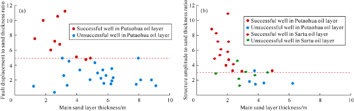
Fig. 8.
Faults of composite reservoir zone of Putaohua oil layer (a), structure amplitude of Sartu, Putaohua oil layers (b) relationship with main sand body on west slope.
Based on the analysis of hydrocarbon accumulation characteristics and main controlling factors, hydrocarbon migration and accumulation models of the west slope have been figured out (Fig. 9). The migration and accumulation pattern of updip pinchout lithologic hydrocarbon reservoir is mostly seen in Fularji and Jiang55 block. The lithology-structure hydrocarbon accumulation model is mainly seen in Jiangqiao and Talahong areas. The structure-lithologic accumulation model is commonly seen in Alaxin and Baiyinnuole regions. The structure hydrocarbon accumulation model is mainly dis-tributed in Fulaerji, Alaxin, Erzhan and Baiyinnuoler areas. The fault-lithologic hydrocarbon accumulation model is mainly found in Taikang anticline belt and the edge of west Longhupao anticline belt. The lithologic hydrocarbon accumulation model is mainly distributed in Alaxin, Erzhan, Baiyinnuoler and Talahong areas.
Fig. 9.
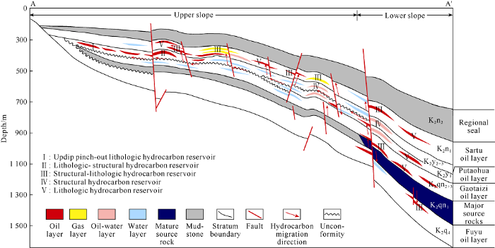
Fig. 9.
Hydrocarbon accumulation models in the west slope of the northern Songliao Basin (the profile position in
3. Distribution of oil and gas in the west slope
3.1. Nose-ike structure controls hydrocarbon accumulation
The slope zone has a series of nose-like structures. Under the action of buoyancy, oil and gas first gathered toward the nose like structures and then continued to migrate a long distance to the updip direction along the structural ridge like in the pipeline. Eventually they accumulated in appropriate areas[28,29]. Studies of hydrocarbon generation and discharge show[30] that the late period of Mingshui Formation deposition is the primary hydrocarbon expulsion period of mature source rock of Qingshankou Formation in Qijia-Gulong sag. Longhupao-anticline zone and the nose-like structures such as Baiyinnuoler, Erzang, Alaxin and Jiangqiao (Fig. 4) on the west slope from east to west began to take shape before or at the same time with the late period of Mingshui Formation deposition, and are on the direction of hydrocarbon migration and accumulation. The exploration practices show that more than 70% of the discovered hydrocarbon reservoirs in the west slope are around these nose-like structures, indicating that these structures in the slope area have a strong influence on hydrocarbon enrichment and accumulation.
3.2. Faults control hydrocarbon vertical migration and accumulation
Faults play an important role in the process of hydrocarbon accumulation, and they can act as either hydrocarbon vertical migration paths or seals of accumulations. From Fig. 10, there are three groups of faults striking north-east, north-west and near south-north in Longxi-Xingxi area. The north-east faults are mostly located in the eastern part of the study area. The most significant ones are Aogula, Halahai and Qixi faults which are long active and connect to the source and seal oil and gas laterally. Mostly in the middle and east of the study area, the north-west faults are the main faults connecting the source and paths for hydrocarbon migration. The near south-north faults, located in the south and east of the Aogula-Halahai fault zone, seal the oil and gas laterally, and form composite traps with the north-west sand bodies to control hydrocarbon distribution.
Fig. 10.
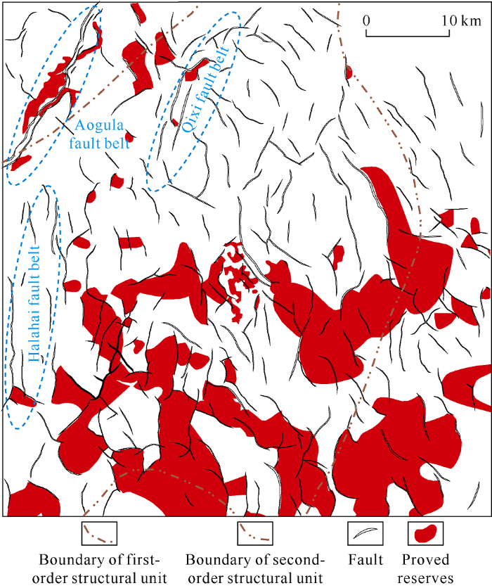
Fig. 10.
Planar distribution of faults on the top surface of Putaohua oil layer in Longxi-Xingxi area.
3.3. Unconformity surface and sand body control hydrocarbon lateral migration
The hydrocarbon accumulation scope in large slope is controlled by the lateral migration distance. The lateral migration channels of the west slope are mainly unconformity surfaces and continuous sand bodies.
During the late Cretaceous (88 Ma ago), a major plate kinematic recombination event took place in the Pacific plate[31], which resulted in the uplift and denudation of Songliao Basin and the T1-1 regional unconformity (bottom of the Yaojia Formation, Fig. 6). The bottom conglomerate or thin sandstone above the unconformity and the semi-weathered rock below the unconformity may both act as migration channels for oil and gas[32]. Oil and gas generated from the source rock of Qingshankou Formation in Qijia-Gulong sag first entered the Gaotaizi reservoir along the unconformity and then migrated laterally and accumulated along the unconformity to form reservoirs. The continuous distribution of unconformity (T1-1) plays an important role in hydrocarbon migration in the west slope.
On one hand, sand body provides favorable storage space for hydrocarbon accumulation; on the other hand, the denser the sand bodies, and the better the connectivity between sand bodies, the easier it is for hydrocarbon to migrate laterally. It can be seen from the sand body profile of the west slope (Fig. 11), the sand bodies of Putaohua oil layer mainly include delta front distributary channel, estuary dam and sheet sand with large thickness. The underwater distributary channel sand bodies are generally 3-5 m thick and 200-300 m wide. The estuary dam sand bodies are generally 2-3 m thick. The sheet sands are generally 1-2 m thick. With a net-gross ration of 20%-50%, the sand bodies are in poor connectivity vertically and laterally. The sand bodies of Sartu oil layer mainly include delta front distributary channel, estuary dam, sheet sand and shore-shallow lake sand dam in stable distribution. The underwater distributary channel sand bodies are generally 2.5-4.0 m thick and 100-300 m wide. The estuary dam sand bodies are generally 2-3 m thick and the sheet sands are generally 1.5-2.5 m thick. With net-gross ratio of generally 25%-55%, the sand bodies are stable in lateral distribution and good in connectivity. The continuous sand bodies widely distributed in west slope act as the main hydrocarbon transportation layers.
Fig. 11.
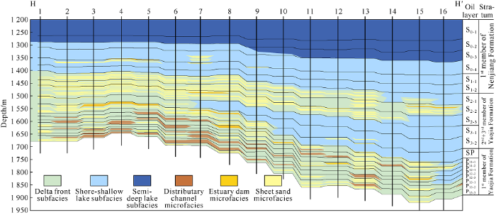
Fig. 11.
The anatomy of sand bodies in the Sartu and Putaohua oil layers in the west slope (location is shown in
3.4. Regional cap rocks provide good sealing conditions
The regional cap rocks in the north and central Songliao Basin are mudstone of the 1st and 2nd members of Nenjiang Formation (Fig. 2). This set of mudstone caprock is stable with a successive thickness of over 200 m and almost spread all over the basin, which provides good sealing conditions for the formation of hydrocarbon reservoirs and space for the long distance hydrocarbon migration. Through the analysis of sedimentary system (Figs. 2 and 11), there was a large area of semi-deep lake and deep lake facies in the period of 1st and 2nd members of Nenjiang Formation. The rocks are mainly mudstone with a small amount of siltstone and fine sandstone that are highly compacted. There is abnormal high pressure because the fluid in the formation is not easy to discharge during sedimentary compaction. In addition, the mudstone cap rock has strong plasticity and is not likely to form cracks[1], which enhance its sealing ability. More than 90% of the oil resources in Songliao Basin enriched in Sartu, Putaohua and Gaotaizi oil layers are under this regional cap rock.
Based on the study of main controlling factors and hydrocarbon distribution regularities, Longxi-Xingxi, north Qijia, Gulong and Taikang uplift have been sorted out as four areas for detailed exploration in the slope area in the near future.
4. Target identification and exploration practice
With the exploration in recent decades, the west slope has entered a stage of high exploration degree and the remaining reservoirs are characterized by small scale, scattered distribution, strong concealment and complicated oil-water relationship. Through fine research on both vertical and horizontal, the "Four Fine" method has been established and working model of integration of geology and geophysics has been set up. In this way, exploration targets can be identified and high production and high efficiency blocks can be discovered. It is a new way for fine exploration in the old area, which is of great significance for fast extension of exploration in the next step.
4.1. Target fine identification and effectiveness evaluation
The remaining traps of combination reservoirs in the slope area have small scale, low amplitude and small controlled reserves. Fine identification and effectiveness evaluation techniques for composite traps have been studied vigorously. Composite trap identification method by combining multiple techniques, such as fault identification by type, micro-structure identification, fine sedimentation research and lithologic trap identification by waveform indication inversion has been worked out. Then the evaluation criteria for effective traps can be determined by the analysis of the match between fault and sand body, structural amplitude and sand body. At last, eligible traps can be sorted out and targets confirmed (Fig. 12), so as to improve the success rate and economics of exploration.
Fig. 12.
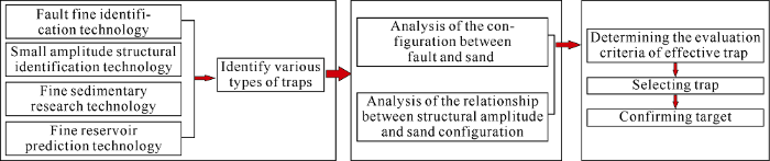
Fig. 12.
Flow chart of fine identification and effectiveness evaluation of trap.
4.1.1. Identification technique of faults by type
In view of the fault displacement and the difficulty for identification on seismic profile, faults are divided into three types and identified by different techniques in order to improve the precision of identifying small faults and combination of small faults on the plane. (1) If the fault displacement is over 10m, the similarity of waveform among seismic traces near the fault is quite different and the fault is completely broken, the coherence volume attribute and variance volume attribute can effectively identify the fault. (2) If the fault displacement is between 5 and 10 m, the in-phase axis is not completely broken and the in-phase axis inclination changes at the fault, frequency division coherence attribute, inclination attribute and curvature attribute can identify the fault effectively. (3) If the fault displacement is less than 5 m, the in-phase axis only bends or deflects, it can be effectively identified by construction-oriented filtering and curvature attribute.
4.1.2. Identification technique of micro-amplitude structure
The key technologies such as stratigraphic correlation by combining logging and seismic data accurate stratigraphic interpretation constrained by well information, time-depth conversion by scale method and large-scale structural mapping are used to identify micro-amplitude structural traps to solve geological problems such as inconsistencies between geological stratification and seismic strata, slight fluctuations in capturing the in-phase axis, changes in micro-structure morphology and interpretation errors, so micro structures with over 3 m amplitude can be accurately identified.
4.1.3. Detailed research techniques of sedimentary microfacies
Through the vertical subdivision of the layers (Fig. 11) and downsizing the research unit, Sartu and Putaohua oil layers were subdivided into 20 units, of which 9 units are in Putaohua oil layer and 11 units in Sartu oil layer. Each unit is 3-10 m thick including 1-2 phases of channels. Among them, the channel sand bodies in phases of S1, S2 and S3 are developed and large in scale, so are the main strata for exploration. The distribution of river sand bodies in each period has been figured out by the combination of logging and seismic data and large scale industrial mapping.
4.1.4. Identification technique of lithologic traps by waveform indication inversion
It is suitable for the reservoir of thin interbeded sand and mud. Firstly, the seismic waveform is used to replace the variation function to solve the problem of insufficient application of the previous seismic information between wells and keep the transverse resolution of the seismic data. Then the seismic waveform indication inversion technique is used to improve the identification accuracy of single sand body, and the lithologic boundary is delineated by subdivision of strata to identify favorable lithologic traps. The identification coincidence rate of single sand layer greater than 3 m is more than 70% by this method.
Based on the technical research results above and the understanding of the match of fault displacement and main sand body, and micro-amplitude structure and main sand body controlling the accumulation, 341 favorable traps of various types with a total area of 947.8 km2 have been selected in the four target areas of Longxi-Xingxi, providing replacement areas for detailed exploration of conventional oil.
4.2. Exploration results
Under the guidance of the geological knowledge above, the fine identification and effectiveness evaluation of targets in the research area were carried out. In 2016, Well Ta66 and Long45 drilled in Longxi area obtained high oil flow, marking great progress of fine exploration in the old exploration area. The conventional oil fine exploration method established provides an effective way for fine exploration in the old exploration area. In the past two years, a total of 82 pre-exploration and evaluation wells were drilled in Longxi area, of which 69 have obtained industrial oil flow, and 32 wells have high-yield oil flow of above 10 t/d. On the basis of the exploration achievements in Longxi area, the exploration model of Longxi area has been promoted to other areas. Several wells in areas such as north Qijia and Taikang uplift zone obtained high oil flow of over 10 t/d, marking major progress in several areas. As high-yield and enrichment blocks were found in the old exploration area, the oil reserves increased over 1×10⁸ t, providing more high-quality recoverable reserves for the sustainable development of Daqing oilfield.
5. Conclusions
The west slope is a wide and gentle slope with large scale dipping east. From east to west, it includes Longhupao anticline belt, Baiyinnuoler, Erzhan, Alaxin, Jiangqiao nose-like structures and the western overlapping zone, which are on the direction of hydrocarbon migration. The extensive delta facies sand bodies provide favorable reservoir space for hydrocarbon accumulation. The slope is divided into upper slope and lower slope according to source rock, structure, sand body and hydrocarbon migration. The upper slope has mainly Sartu oil layer and structure reservoirs. The lower slope has several oil layers and largely composite reservoirs. It is found that the nose-like structures control the degree of hydrocarbon accumulation, faults control vertical migration and sealing, unconformity surfaces and continuous sand bodies control the lateral migration distance. The structures, faults and sand bodies work together to form three types of reservoirs, structural reservoir, structural - lithologic reservoir and lithologic reservoir. A method to identify hidden traps and make effective evaluation has been established which combines "fine structure, fine deposition, fine reservoir and fine accumulation". The method can precisely predict exploration target and improve the success rate of exploration. Great breakthroughs have been made by fine exploration in the old exploration area, and a group of micro-amplitude structures in the slope surrounding the sags such as Taikang uplift belt are sorted out as the next exploration objectives.
Reference
Crude oil mobility and its controlling factors in tight sand reservoirs in northern Songliao Basin, China
Study on oil and gas source and migration of Western slope area in northern Songliao Basin
Petrological characteristics and shale oil enrichment of lacustrine fine-grained sedimentary system: A case study of organic-rich shale in first member of Cretaceous Qingshankou Formation in Gulong Sag, Songliao Basin, NE China
Migration and accumulation of oil and gas in a simple slope area: A case study on the Wastern Slope of the Northern Songliao Basin
Tectonic intensity and oil and gas migration of West Slope in Songliao Basin
The pool-forming pattern and main control factors in west slope of the North of Songliao Basin
Study on the control effect of fracture of source outer slope area on the distribution of oil and gas accumulation
Characteristics of oil-gas accumulation in northern sector of the West Slope, Songliao Basin
Hydrocarbon accumulation factors of the Slope area outside of source area: A case study of West Slope area in Songliao Basin
Slope oil and gas exploration
The intension and signification of “Sag-wide Oil-Bearing Theory” in the hydrocarbon-rich depression with terrestrial origin
Stratification characteristics and genesis analysis of Yaojia Fm in the northern west slope of Songliao Basin
Oil and gas reservoir formation conditions and exploration potential of the complex fault block zone in the west slope of Dongpu Sag
Reservoir pattern and exploration practice of lithologic strata in the gentle slope zone of faulted Lake Basin: Taking Wenan slope and Li County slope in Jizhong Depression as an example
Analysis of main controlling factors of Triassic oil and gas accumulation in Junggar Basin and Cheguai slope area
Slope belt types and hydrocarbon migration and accumulation mechanisms in rift basins
DOI:10.1016/S1876-3804(16)30100-8 URL [Cited within: 2]
Hydrocarbon accumulation law of the second member of Kongdian Formation in the Slope Zones of Cangdong Sag
Geological characteristics and hydrocarbon accumulation of Nanpi Slope in Cangdong Sag, Bohai Bay Basin
Sedimentary characteristics of the Cretaceous Songliao Basin
DOI:10.1016/j.micron.2019.102702
URL
PMID:31252333
[Cited within: 1]

High-resolution X-ray computed tomography (micro-CT) has been widely used as a non-destructive technique, allowing 3D imaging and analysis of internal features of various objects. This paper briefly describes this technique used in the field of petroleum geology, with an example of its applications for tight-gas sandstone reservoirs. Reservoir quality controls the storage, distribution, and flow of fluids within tight-gas sandstone reservoirs, however, it remains difficult to predict. Although our earlier work has reported that reservoir quality of non-marine tight-gas sandstones in the Lower Cretaceous Denglouku Formation in the Songliao Basin, China is controlled by sedimentary texture, depositional facies, and diagenesis, there is lack of information on the effectiveness of pore-lining clay minerals on pore preservation and pore connectivity. Micro-CT is performed on two representative sandstone samples from the studied Denglouku sandstones, (1) to quantify the internal architecture in 3D and (2) to carry out fluid-flow modelling to determine the effective transport capacity. The quantitative 3D imaging and modelling by means of micro-CT provides a better insight of pore network connectivity and pore preservation characteristics at the pore scale. Here, we develop a procedure that integrates pore-scale imaging and modelling with depositional and diagenetic processes in the context of non-marine tight-gas sandstones. Micro-CT data are compared with results derived from core and wireline log interpretation as well as laboratory measurements on the same core samples, which results in good agreement and supports the prediction of pore preservation effectiveness of the sandstones containing pore-lining chlorite and illite with relatively high grain-surface coverage. It opens a potential opportunity for a pore-to-core upscaling approach to predict reservoir quality for tight-gas sandstones.
Prediction of favorable lithostratigraphic traps zone of the middle-upper part of the third member of the Qingshankou Formation in the West Clinoform of the Northern Songliao Basin
Magnetopolarity zone and geological age of the Nenjiang formation at the CCSD-SK-1 drill core in the Songliao Basin
Significance of research on oil and gas migration flow in composite oil and gas-bearing system
Main transport channels for oil and gas migration in the western slope zone of Songliao Basin
Evaluation of natural gas efficiency in sand body transport layer of two or three reservoir in West Slope area
To study gas-transporting efficiency through sandbody, a parameter to evaluate gas transportation ability through sandbody was set up based on the analysis of factors influencing gas- transporting ability through sandbody. Using the evaluation parameter of gas-transporting ability through sandbody, 11 large and medium gas fields of which the gas-transporting pathway is sandbody were studied. By the study on the relationship between gas accumulation efficiency and evaluation parameter of gas- transporting ability through sandbody of the above-mentioned gas fields, it was considered that the evaluation parameter of gas-transporting ability through sandbody with high, middle and low efficiency to be separately more than 0.25,0.25~0.03and less than 0.03. According to transportation characteristics through sandbody of S2+3 oil layer in west slope region, gas-transporting efficiency through sandbody in the region was studied. It was believed that gas-transporting efficiency through gandbody of S2+3 oil layer in west slope region was high. Although gas-transporting efficiency is middle and low at the limited area in the west of Fulaerji, gas-transporting efficiency is high in other regions. All gas reservoirs of S2+3 oil layer in west slope region now distribute in gas-transporting area through sandbody with high efficiency. It indicates that its own good transporting condition is the main reason for gas from Qijia-Gulong sag to migrate to west slope region.
Distribution and migration characteristics of the heavy oil tinidazole compounds in Songliao Basin
Analysis on reservoir formation condition and reservoir formation combination of middle and new system in the southeast of Jonglei Basin
There is a very low exploration and study extent to Miocene stratum in Qiongdon gnan basin, and the result of the study is not very goodThough there were good oil and gas show generally to be seen in the Miocene stratums, but the logg ing interpretation hasn't found hydrocarbon beds Because the varied reasons, only Sanya formation of Miocene in Ya 13-1, Ya13-4, Ya 13-6 and Meishan for mation in BD 19-2 structures have been found to have high production commercial gas or better discovery But the other areas haven't got a good finding So t he Miocene oil and gas exploration potential is still be very big So we think , to wholly and systematacially analyze and summarize Miocene exploration result s and the oil and gas transferring and collecting law,and to strengthen the exp loration and study to Miocene in this area, we believe that we must make an improvement.
Study on the dynamic factors of oil and gas migration in the western slope zone of Songliao Basin
The oil recharge event defined by the K2Ar dating of the authigenic illite proved to be episodic indicated by the following two factors. First, the recharge time is clustered in the following four periods, 60Ma, 58Ma, 45Ma、and 45-32Ma. Second, the first 3 stages of oil recharge are widely sp read in the whole west slope zone of the Songliao basin. The oil-recharge event happened in two different places far away from each other (35km linearly) linked by the hydrocarbon migration pathway systems. According to the oil recharge time, the minimum hydrocarbon migration velocity is estimated to be greater than 4. 5km /Ma, which cannot be exp lained bywater dynamics and density difference between formation water and hydrocarbon. The velocity driven by the late two factors are estimated to be less than 2km /Ma, far less than the actual hydrocarbon migration velocity. Thismeans that there exist other factors that driven the hydrocarbon to migrate westward. It is suggested here that the hydrocarbon migration and concentration wasmainly controlled by the tectonic comp ression during the Paleogene. First, tectonic comp ression has p romoted the initialmigration of the hydrocarbon by strengthening the overp ressure generated in the mudrock and driven the hydrocarbon out of the microfissures generated during the basin extension. Second, the ep isodic movement of the tectonic comp ression will result in the ep isodic movement of the formation fluid, which will drive the hydrocarbon migration and concentration ep isodically. This is whatwe found in the west slope zone of the Songliao basin. Finally, tectonic compression in an E-W direction has generated many anticlines in the basin, which is the most important trap in the Songliao basin.Tectonic compression has changed the characters of the faults that striking NNE,NE,which resulted in the forming of many fault-sealed oil reservoirs in the study area.
Late Mesozoic and Cenozoic rifting and its dynamic setting in Eastern China and adjacent areas
DOI:10.1016/S0040-1951(01)00271-2 URL [Cited within: 1]
Vertical dominant migration channel and hydrocarbon migration in complex fault zone, Bohai Bay sag, China
