


Introduction
In recent years, major breakthroughs have been made consecutively in petroleum exploration of the Junggar Basin, and two large oil fields, Mahu and Jimusaer, each with oil reserves of 10×108 t have been discovered. However, except the Kelameili large gas field discovered in 2008, the natural gas exploration has seen no breakthrough in over a decade. The oil and gas exploration results show that the basin has "more oil and less gas", with a ratio of proved natural gas reserves to oil reserves being only 0.06:1, which is apparently different from other large petroliferous superimposed basins in central and western China. The “more oil and less gas" phenomenon does not match with the geological conditions of natural gas in the basin: (1) It does not match with the main types of source rocks. The Junggar Basin mainly develops three sets of source rocks, Carboniferous, Permian and Jurassic, among which the Carboniferous-Lower Permian Jiamuhe Formation and Jurassic are coal measure source rocks with large thickness and wide distribution that generate gas primarily and have huge gas generation potential. (2) It does not match with the ultra-deep buried depth of the source rocks. The Carboniferous-Permian source rocks in the Junggar Basin are old and deeply buried, at 10 000 m to 12 000 m and up to over 15 000 m depth in the Central Depression belt, so they have reached high thermal maturity with the capacity of massive gas generation. (3) It does not match with the exploration fields of the southern and northern foreland thrust belts of the Tianshan mountains. The southern and northern foreland thrust belts of the Tianshan mountains have similar structural and sedimentary geological backgrounds, and macroscopic conditions for hydrocarbon accumulation. The foreland thrust belt of Kuche in the south has formed a large gas area of over a trillion cubic meters of reserves, while only five medium-small fields with proven gas geological reserves of 346×108 m3 have been discovered in the foreland belt in southern Junggar Basin in the north of the Tianshan mountains. The exploration results of natural gas in these two foreland belts differ greatly.
From the perspective of exploration degree, the Junggar Basin has a low proven rate of natural gas of only 9.0%, which is still in an early exploration stage. Although the discovered natural gas fields (reservoirs) are mainly small and medium-sized secondary gas reservoirs, there is also a large Carboniferous gas field, Kelameili, with a reserve scale of 100 billion cubic meters. Based on the recognition of geological conditions and distribution pattern of natural gas, the authors believe that the Junggar Basin still has the basic geological conditions for forming large to medium-sized gas fields (reservoirs), and there are three key natural gas exploration fields and directions with considerable exploration potential of natural gas.
1. Exploration overview
Hydrocarbon exploration in the Junggar Basin started relatively late, with proven reserves of natural gas firstly submitted in 1983. The exploration history of natural gas in this basin can be roughly divided into the following three stages: (1) The accompanying development stage (1983-1998): natural gas exploration mainly developed along with the oil exploration. In this stage, nine small gas fields (reservoirs) were discovered successively, including Xiazijie, Santai and Wucaiwan, with proven cumulative reserves of 353×108 m3. (2) The major discovery stage (1999-2008): with the discovery of Hutubi gas field in 1999 as a turning point, eight large to medium- sized gas fields were discovered later on, including Hutubi, Mosuo Bay, Mahe and Kelameili, with proven cumulative reserves of 1619×108 m3, making this stage the most fruitful. (3) The stage poised to breakthrough (2009-2018): Although only the Jinlong gas field was discovered with proven gas reserves of 120×108 m3, several new discoveries have been made recently in the southern thrust belt and the eastern uplift zones of the Dinan Uplift, with probable and possible gas reserves of 1074 × 108 m3 submitted, showing a promising exploration outlook.
After more than 30 years of development, 18 gas fields (reservoirs) have been discovered in the Junggar Basin, with proven gas reserves of 2092×108 m3 and annual gas production of 28.4×10⁸ m3 in total. These discovered natural gas fields (reservoirs) contain 5 pure gas reservoirs (75% of the reserves) and 11 associated gas reservoirs (25% of the reserves). The natural gases include coal-type gas, oil-type gas, mixed gas and biodegraded gas, but mainly coal-type gas, accounting for 70% of the reserves (Table 1)[1,2,3,4,5,6,7,8,9]. Although the number of pure coal-type gas fields (reservoirs) discovered is small, the size of single gas reservoirs is large and they are the main part of the discovered natural gas reserves. Therefore, coal-type gas is the main target for large and medium-sized gas fields (reservoirs) in the Junggar Basin.
Table 1 Parameters of the discovered gas fields (reservoirs) in the Junggar Basin.
| Name of gas fields (reservoirs) | Type of natural gas | Gas reservoir type | Formation of gas-source rock | Proven reserves/108 m3 | Discovery date |
|---|---|---|---|---|---|
| Xiazijie | Oil-type gas | Associated gas | Fengcheng Formation | 44.97 | 1983 |
| Santai | Coal-type gas | Associated gas | Carboniferous, Jurassic | 27.35 | 1988 |
| Karamay | Mixed gas | Associated gas | Fengcheng Formation | 214.87 | 1991 |
| Dushanzi | Coal-type gas | Associated gas | Jurassic | 4.88 | 1994 |
| Shixi | Coal-type gas | Associated gas | Lower Wuerhe Formation | 20.15 | 1995 |
| Chepaizi | Mixed gas | Associated gas | Lower Wuerhe Formation | 6.12 | 1995 |
| Shinan | Coal-type gas | Associated gas | Lower Wuerhe Formation | 6.89 | 1997 |
| Wucaiwan | Coal-type gas | Gas layer gas | Carboniferous | 8.33 | 1997 |
| Xiaoguai | Mixed gas | Associated gas | Jiamuhe Formation, Lower Wuerhe Formation, Fengcheng Formation | 20.20 | 1998 |
| Mobei | Coal-type gas | Associated gas | Lower Wuerhe Formation | 93.56 | 1999 |
| Hutubi | Coal-type gas | Gas layer gas | Jurassic | 146.22 | 1999 |
| Mosuowan | Coal-type gas | Gas layer gas | Lower Wuerhe Formation | 119.20 | 2001 |
| Hongshanzui | Mixed gas | Associated gas | Jiamuhe Formation, Lower Wuerhe Formation | 1.31 | 2001 |
| Cainan | Coal-type gas | Associated gas | Carboniferous | 26.85 | 2002 |
| Luliang | Biodegraded gas | Associated gas | Lower Wuerhe Formation | 10.81 | 2006 |
| Kelameili | Coal-type gas | Gas layer gas | Carboniferous | 1115.63 | 2008 |
| Mahe | Coal-type gas | Gas layer gas | Jurassic | 167.66 | 2008 |
| Jinlong | Mixed gas | Associated gas | Jiamuhe Formation, Lower Wuerhe Formation, Fengcheng Formation | 57.50 | 2014 |
2. Geological conditions for forming large and medium-sized gas fields (reservoirs)
2.1. Source rocks
The first set is the coal measure source rock formed in Carboniferous-Lower Permian Jiamuhe Formation deposited at the ocean-land transition stage of the Late Hercynian. Mainly distributed in the three active continental margin belts in the northeast, northwest and southeast of the basin, it is 100-300 m thick, 3×10⁴ km2 in area, contains mainly type Ⅲ organic matter with a TOC value ranging from 0.5% to 43.7% (on average 4.40%). The samples of Lower Carboniferous source rock have vitrinite reflectance values (Ro) of 0.55%-4.21% (on average 1.42%), and most of the samples are highly-matured to over-matured. The samples of Upper Carboniferous source rock have Ro values of 0.54%-1.83% (on average 0.97%), and most of the samples are in matured to highly- matured stage. The dynamic simulation of hydrocarbon generation shows that the Carboniferous source rock is fairly late in hydrocarbon generation and begins to generate gas massively when reaching the Ro of over 1.2%, and has gas kitchen area of 1.97×10⁴ km2. The Carboniferous rock is the most important gas source rock in the Junggar Basin at present, which supplies gas for the Zhongguai and Wuba District in the western basin and Kelameili gas field in the eastern basin.
The second set is the lacustrine source rock deposited in the faulting to depression transition stage of Permian, including the Fengcheng Formation and Lower Wuerhe Formation. It is the most important set of oil source rock in the Junggar Basin, which provides oil for most oil reservoirs discovered in this basin. Mainly distributed in the northwestern margin of the basin, the source rock of the Fengcheng Formation has a thickness of 0-225 m, Type Ⅰ-Ⅱ1 organic matters, a TOC value ranging from 0.61% to 4.01% (on average 1.38%), and Ro ranging from 0.85% to 1.22%, which is at peak of oil generation stage. It is inferred that it has reached the stage of cracked-gas generation deep in the sag, with an area of gas source rock of 1.71×10⁴ km2. The source rock of the Lower Wuerhe Formation is distributed mainly in secondary sags like Mahu, west Well Pen1, Shawan and Fukang in the Central Depression of the basin. It has a thickness of 0-200 m, Type Ⅱ-Ⅲ organic matter, a TOC value ranging from 0.50% to 9.16% (on average 1.73%), and Ro ranging from 0.7% to 1.0%, and just reaches the peak of oil generation. It is inferred that it has entered gas generation stage in the deep parts of the sags, and has an area of gas source rock with Ro larger than 1.6% of 1.55×10⁴ km2. The Permian source rocks in the Central Depression belt are buried at a depth of around 10 km, with the maximum buried depth of more than 15 km, which have the conditions and potential for generating large-scale gas[12,13]. The oil-type gas coming from the Permian source rocks has been found in the western, central and eastern Junggar Basin.
The third set, a set of major gas source rocks in the basin, is the coal measure source rock of the Middle and Lower Jurassic deposited in the Mesozoic coal-accumulating basin period. Being largely shallow water lacustrine sediments, this set of source rock has a thickness of 100-800 m, an area of 9.4×10⁴ km2, Type Ⅱ2-Ⅲorganic matter, and mainly consists of carbonaceous mudstone with a TOC value ranging from 6.03% to 39.96% (on average 18.22%) and coal with a TOC value ranging from 41.79% to 91.94% (on average 64.73%). As the Junggar Basin of the Himalayan Period tilted southward, the mature source kitchens of the Jurassic are mainly in the southern Junggar Basin. The samples of this set source rock from the outcrop profile and a small number of exploratory wells have measured Ro values from 0.61% to 0.72%, which is in the low-matured to matured stage. Because these samples were generally located at the structural high parts, they cannot fully reflect the real situation deep in the sag. According to the basin simulation and natural gas geochemical characteristics, it is inferred that the source rocks of the Middle and Lower Jurassic in the main structures of the southern Junggar Basin have all entered high-over mature stage, with an equivalent Ro ranging from 1.3% to 2.6%. When the Ro exceeds 1.2%, the source rock begins to generate gas massively, and the gas kitchen reaches an area of 1.41×10⁴ km2 (Fig. 1). The natural gas of Hutubi gas field and Mahe gas field in the southern Junggar Basin all comes from this set of source rock.
Fig. 1.
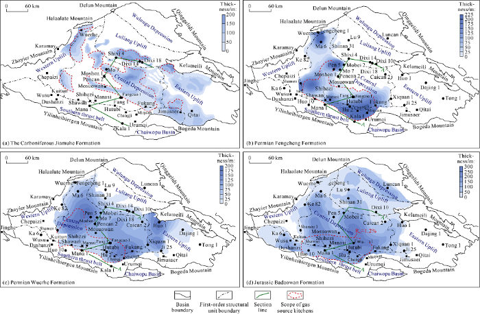
Fig. 1.
Predicted thickness and gas generation area of the main source rocks in the Junggar Basin.
The main gas kitchens of the three sets of source rocks shows zoning distribution on the plane, and not completely superimpose vertically. The superposed area of the gas kitchens reaches 6.64×10⁴ km2, laying a solid foundation for forming large and medium-sized gas fields (reservoirs). In addition, the geothermal field of the Junggar Basin has the characteristics of "early hot and late cold". The geothermal gradient has been decreasing continuously since the late Paleozoic[13,14,15,16,17], and was 5.5 °C/100 m at the end of the Carboniferous (300 Ma from now), 4.5 °C/100 m in the Early Jurassic, and is 2.3 °C/100 m now[14,15,16,17,18]. Compared with the other continental basins in China, the Junggar Basin is lowest in geothermal gradient now. The characteristics of low geothermal field have determined that the thermal evolution of hydrocarbon source rocks is relatively slow, and greater buried depth is needed for the source rocks to reach the same maturity and gas generation threshold, so the main gas generation window would go deeper, and the main gas source kitchens would appear at much larger buried depth. The exploration of natural gas in the Junggar Basin has mainly concentrated on the moderately to shallowly buried formations at present, and the discoveries are mainly the small to middle-sized secondary gas reservoirs. Large primary gas reservoirs should be developed in the vicinity of the main gas source kitchens in the moderately to deeply buried formations. The limited exploration depth and understanding result in "more oil but less gas" discovered, the potential of natural gas resources may be underestimated.
2.2. Reservoirs
There are two types of natural gas reservoirs in the Junggar Basin, volcanic reservoirs and clastic reservoirs. The volcanic reservoirs developed in the Carboniferous-Early Permian are mainly mid-basic lava and pyroclastic rocks in the environment of island arcs and rifts. The reservoirs consist of a variety of rocks of different lithologies, including andesite, basalt, tuff, volcanic breccia, rhyolite, etc. Among them, mid-basic lava is distributed in the Permian of northwestern margin and Carboniferous of the hinterland and east of the basin; while the pyroclastic rocks are widely distributed across the basin. The reservoirs are highly heterogeneous, with primary pores, secondary dissolution pores and fractures[19]. The physical properties of volcanic reservoirs are hardly affected by buried depth, but mainly controlled by the lithology and weathering and leaching time, and volcanic rocks with various kinds of lithologies can all form favorable reservoirs after long-term weathering and leaching. Weathering and leaching is the main controlling factor for the formation of favorable reservoirs in the weathered crust of volcanic rocks. Simulation shows that the process of weathering would reach an equilibrium after 20 Ma, the equilibrium thickness of weathered crust reservoir is approximately 550 m, and the cores collected prove that the maximum porosity is up to 24%[20]. The high-quality volcanic reservoirs revealed by drilling are mainly concentrated within 550 m down from the top of the weathered crust, but the reservoir depth of the weathered crust can further extend down to a depth of 1100 m from the top of the weathered crust when faults exist, and the coring proves that the reservoirs have a maximum porosity of 32%[20]. The reservoirs of volcanic weathered crust are mainly distributed in the Western Uplift, Eastern Uplift and Luliang Uplift of the basin.
The clastic reservoirs are composed of sandy conglomerates and sandstones. The sandy conglomerate reservoirs are mainly developed in the Permian, Triassic and Tertiary, and distributed in the frontal facies belt of each major sedimentary system, with high heterogeneity. They have both primary inter-granular pores and secondary dissolution pores, and become worse in physical properties with increase of buried depth in general. For example, for the Permian in the northwest margin of the basin, the average porosity of the sandy conglomerates in the Jiamuhe Formation, Fengcheng Formation and Xiazijie Formation ranges from 2.28% to 11.19%. On the plane, the reservoirs in the Kebai Fault zone in the northwestern margin are slightly better in physical properties, with a porosity of more than 10% generally, and the reservoirs gradually worsen in physical properties from the northwestern margin to the central part of the basin. In the eastern part of the basin, the Lower Wuerhe Formation of the Permian has a porosity ranging from 5.24% to 10.79% except in the Huoshao Mountain area where it has an average porosity of 10.7%. In contrast, the reservoirs of the Lower Wuerhe Formation in the northwestern margin are better in physical properties in general, with porosity ranging from 9.68% to 12.11%. Toward the central part, the reservoirs turn poorer in quality, with porosity ranging from 6.28% to 10.94% in Mabei-Luxi-Shixi areas. But the development of the secondary dissolution porous belt in the deep formations can significantly improve reservoir quality. For example, the sandy conglomerate reservoir of the Triassic Baikouquan Formation in the Mahu sag is under the control of secondary dissolution, where the effective reservoirs still developed at the depths of more than 4500 m, with porosity ranging from 10% to 15%. Actual drilling reveals that effective reservoirs developed with a porosity of about 10% at a depth of 6000 m in the Central Depression belt owing to secondary dissolution. The sandstone reservoirs mainly developed in the Jurassic-Paleogene, and the sandstone reservoirs in non-coal-bearing formations (Paleogene, Cretaceous, Jurassic Qigu Formation, Toutunhe Formation, Sangonghe Formation) are better in physical properties than those in coal-bearing formations (Xishanyao Formation and Badaowan Formation). On the plane, the Cretaceous sandstone reservoir has a porosity ranging between 12% and 28%, among which the Cretaceous Qingshuihe Formation sandstone at the buried depth of 6000 m in the Sikeshu sag has a porosity of 16.8%. The Jurassic Qigu Formation is distributed limitedly at the margins of the basin, while it has been basically denuded in the heartland of the basin. Except for the southern margin of the Kayindike area where the Jurassic sandstone is poor in physical properties with an average porosity of 8%-11.2% due to the deeply buried depth, the Jurassic sandstone in the other areas are better in physical properties due to shallow depths. For example, in the northwestern margin, the Jurassic sandstone is at the buried depth of greater than 1000 m and has a porosity ranging from 18% to 28%. The sandstone of the Toutunhe Formation is mainly distributed in the west part, the Luxi area of the central part and the eastern part, and in the southern margin of the basin. The sandstone of Toutunhe Formation is fairly good in physical properties, with a porosity ranging from 12% to 24%. In Sikeshu sag at the southern margin, the sandstone at the depth of 6000 m has a porosity ranging from 9% to 12%. The reservoir of the second member of Sangonghe Formation is the best in quality in the Jurassic. Except for the Santai-Beisantai in the east, Cai35 well area and Shidong area where this member of sandstone has a porosity of less than 12% due to finer grain size, it has a porosity between 12% and 30% in the other areas. This member of sandstone contains mainly primary intergranular pores and is low in heterogeneity.
The weathering and leaching of volcanic rocks and secondary dissolution of sandy conglomerates lead to the development of two types of effective reservoirs in the moderately to deeply buried formations, which provide good reservoir conditions for near-source accumulation of natural gas in the basin.
2.3. Caprocks
The natural gas caprocks in the Junggar Basin are relatively monotonous in lithology and mainly argillaceous rock. From bottom to top, there are six sets of mudstone caprocks, of which three are regional caprocks, including the Upper Permian Wuerhe Formation (P3w), Triassic Baijiantan Formation (T3b) and Cretaceous Tugulu Group (K1tg) (Fig. 2), and the other three are local caprocks, including the second member of Lower Jurassic Badaowan Formation (J1b2), third member of Lower Jurassic Sangonghe Formation (J1s3), and Tertiary Anjihaihe Formation (E2—3a). The first set of regional caprock, the Upper Wuerhe Formation (P3w) is brown and grey-brown mudstone, 50-350 m thick, which is mainly distributed in the Central Depression belt of the basin, onlapping and thinning towards the uplift areas until pinching out. The second set of regional caprock is the Baijiantan Formation (T3b) dark-grey mudstone 100-800 m thick, which is thicker in the western sags and southern margin, but thinner in the central area and east because of the paleouplift, and thins and pinches out towards the paleo-uplift and slope on the whole. The third set of regional caprock is the Cretaceous Tugulu Group (K1tg) dark-grey and greyish-green mudstone 200-2000 m thick. Widely distributed across the basin, it is thickest in the Central Depression belt and southern margin[21], and thins towards the eastern and western flanks until pinches out. The first set of local caprock is the Badaowan Formation (J1b2) dark-grey mudstone (160-260 m thick), which is thicker in the central sags and southern margin of the basin and thins towards the western and eastern slopes. The second set of local caprock is the third Member of the Sangonghe Formation (J1s3) dark-grey and greyish-green mudstone (150-250 m thick), which is mainly distributed in the Central Depression belt and thins towards the west, east and southern margins. The third set of local caprock is the Anjihaihe Formation (E2—3a) greyish-green mudstone (140-180 m thick), which is mainly concentrated in the south of the Central Depression belt and the southern margin. The six sets of mudstone caprocks combine with the underlying reservoirs into favorable reservoir-cap assemblages, and can form effective seals to the natural gas reservoirs under certain geological conditions. Deformation simulation experiments show that a certain buried depth is needed for mudstone caprocks to effectively seal natural gas under pressure, and the critical depths for salt, gypsum and mudstone caprocks of the same thickness changing from brittleness to semi-plasticity and plasticity[22,23,24,25,26] increase in turn. The critical depths for salt caprock, gypsum and mudstone to change from brittleness to semi-plasticity are 600 m, 2000 m and 3200 m respectively[25,26]. The stronger the plasticity, the better the sealing performance of the caprock will be. Mudstone caprocks need a greater buried depth than salt or gypsum caprocks to form effective sealing of the same height of gas column. The characteristics of mudstone caprock alone determine that the gas sealing conditions in the moderately to deeply buried formation are better than those in the moderately to shallowly buried formation in the basin, so large and medium-sized gas reservoirs are more likely to occur in the moderately to deeply buried formations.
Fig. 2.
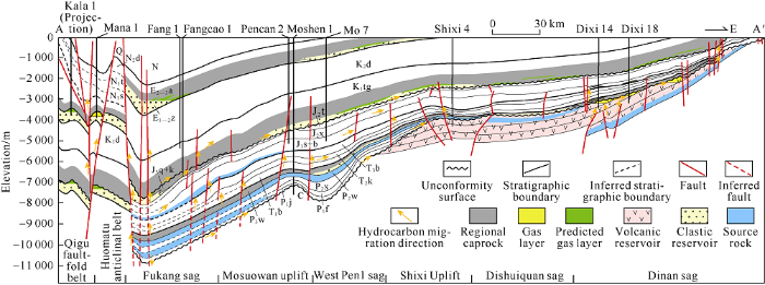
Fig. 2.
Source-reservoir-caprock assemblages and accumulation profile of natural gas in the Junggar Basin (profile position in
3. Formation and distribution of large- and medium-sized gas fields (reservoirs)
3.1. Large and medium-sized gas fields are distributed around sags near sources under the control of the main gas source kitchens
The Junggar Basin has three sets of major source rocks vertically, Carboniferous, Permian and Jurassic source rocks, which form three main gas source kitchens and gas-bearing systems on the plane correspondingly. The gas reservoirs formed by the gas-bearing systems all accumulate around the gas source kitchens around the sags (Fig. 3). Controlled by the distribution of source rocks, the planar distribution of the three main gas source kitchens is obviously zonal. The main gas source kitchens of the Carboniferous, controlled by residual hydrocarbon-generating sags, are mainly distributed in the three active continental margin belts in the northeast, southeast and northwest of the basin. The main gas source kitchens of the Permian, controlled by highly-matured hydrocarbon-generating sags, are distributed in the Shawan, Fukang and West Well Pen1 sags. The main gas source kitchens of the Jurassic controlled both by the distribution of Jurassic source rock and later buried depth, are mainly distributed in the southern margin and Fukang sag. The discovered natural gas reservoirs so far are all controlled by the main gas source kitchens. For example, the Carboniferous gas fields of Kelameili and Wucaiwan are controlled by the main gas source kitchens in Dishuiquan and Wucaiwan, and distributed in the adjacent Dinan Uplift belt. The moderately to shallowly buried gas reservoirs of Mosuowan and Mobei sourcing from Permian are mainly distributed in the vicinity of gas source faults in good configuration with the highly-mature gas source kitchens of the Permian. The Hutubi and Mahe gas fields (reservoirs) sourced by Jurassic are mainly distributed above the main gas source kitchens of the Jurassic in the southern margin (Fig. 3).
Fig. 3.

Fig. 3.
Relationship between the distribution of main gas kitchens and discovered gas reservoirs in the Junggar Basin.
3.2. The stable structural background is favorable for the formation and preservation of large and medium-sized gas fields
The Junggar Basin has experienced multiple stages of tectonic movements[27], including the Hercynian, IndoChina, Yanshanian and Himalayan movements, which are unfavorable for the formation and preservation of large and medium-sized natural gas reservoirs. Under the same geological conditions, natural gas has stronger diffusion ability than oil, so the accumulation of gas demands better caprock sealing capability. The mudstone caprock is likely to break due to its brittleness during the later structural extrusion deformation[25,26], while the stable tectonic setting can eliminate brittle fracturing of mudstone caprock due to tectonic reformation, and thus enable the formation and preservation of large and medium-sized natural gas reservoirs. The stability of tectonic setting is mainly reflected in the three aspects below: (1) the structural inheritance or continuity, that is, the paleo-structure was maintained as a positive structural unit during the accumulation period; (2) there was weak structural reformation in later periods, namely, the formations underwent little uplift and denudation after the accumulation period; (3) the faults in later period brought less damage to the reservoir, that is, after the accumulation period, the faults brought no or less damage to the structure in the early accumulation period. For example, the fault terrace belt and piedmont thrust belt in the northwestern margin underwent the adjustments and reconstructions of multi-stage tectonic movements, where the gas reservoirs formed in the early stage were often difficult to accumulate and preserve in large scale, hence only medium-sized or small gas fields were found in the fault terrace belt in the northwestern margin and Kelameili piedmont. In contrast, the uplift belt located in the central area of the basin basically subsided continuously after the structural uplift in the Hercynian Period, and the gas reservoirs formed in the early stage were not easily damaged in later period, which was conducive to forming large and medium-sized gas fields. For example, the Kelameili gas field is located in the Dinan Uplift belt in the eastern segment of the Luliang Uplift, which is in the central area of the basin (Fig. 3).
3.3. The vertical distribution of large and medium-sized gas fields (reservoirs) is controlled by the reservoir-caprock assemblages
Under the control of four sets of the regional mudstone caprocks, there are three sets of reservoir-caprock assemblages (the lower, middle and upper) developed in the Junggar Basin. In the lower part, the reservoir-caprock assemblages of the mudstones at the top of the Upper Permian Upper Wuerhe Formation and the volcanic rocks in the Carboniferous are developed; in the middle part, the reservoir-caprock assemblages of the mudstones in the Upper Triassic Baijiantan Formation and the conglomerates in the Middle-Lower Triassic, as well as the reservoir-caprock assemblages of the mudstones in the Cretaceous Tugulu Group and the sandstones in the Jurassic and Cretaceous are developed; in the upper part, the reservoir-caprock assemblages of the mudstones in the Paleogene Anjihaihe Formation and conglomerates in the Ziniquanzi Formation are developed (Fig. 4).
Fig. 4.
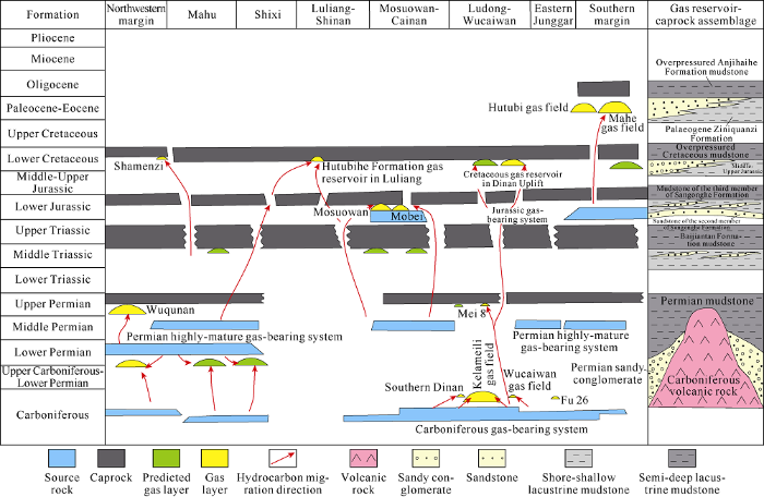
Fig. 4.
Division of reservoir-cap assemblages in composite gas-bearing system of the Junggar Basin (Revised according to the reference [28]).
The vertical distribution of natural gas reservoirs is controlled by the above three sets of reservoir-caprock assemblages. The discovered large and medium-sized gas fields so far are mainly controlled by the upper and lower reservoir- caprock assemblages. The mudstone of the Upper Wuerhe Formation onlapping the paleo-uplift controls the distribution of Carboniferous-Permian natural gas reservoirs, and gas fields like Kelameili, Wucaiwan and Jinlong are all controlled by this reservoir-caprock assemblage. The Anjihaihe Formation overpressured mudstone and the Ziniquanzi Formation sandstone constitute a high-quality reservoir-caprock assemblage in the southern margin of the Junggar Basin, which has the most gas found in this area, and Hutubi and Mahe gas fields are found in this reservoir-caprock assemblage [27]. There are several sets of high-quality reservoir-caprock assemblages of lacustrine mudstone and sandstone in the Triassic-Cretaceous of the Central Depression, which control the distribution of moderately to shallowly buried secondary gas reservoirs. The discovered Mosuowan and Mobei gas reservoirs are controlled by this set of reservoir-caprock assemblage. Although the gas reservoirs found in this set are small in scale, they still deserve great attention (Fig. 4).
4. Favorable exploration directions of large and medium-sized gas fields (reservoirs)
Based on the analysis of macro-geological characteristics of the gas source rocks, reservoirs and caprocks and basic reservoir-controlling rules, through in-depth examination of the gas kitchens, large-scale reservoirs and key reservoir-controlling factors, we have sorted out the Carboniferous volcanic rocks, the lower assemblage in the southern margin and the Central Depression belt as the key directions for natural gas exploration in the future.
4.1. Carboniferous volcanic rocks
The Carboniferous volcanic rocks are the formation with the most gas reserves discovered in the basin. The three major hydrocarbon-generating sags, Dishuiquan, Wucaiwan and Dongdaohaizi were assessed in four times of resource evaluations. The natural gas resources of the Carboniferous were estimated at around 7626×108 m3. Gas fields like Wucaiwan and Kelameili were discovered around these hydrocarbon-generating sags, which have proven gas geological reserves of 1137×108 m3, accounting for 54.3% of the total proven gas geological reserves in the basin.
4.1.1. Hydrocarbon-generating sags are developed in all of the three main active continental margins in the Carboniferous and have gas generation potential
The Carboniferous-Early Permian was in the ocean-continent transition stage. With the closure of the eastern Junggar Ocean, the western Junggar Ocean and the north Tianshan Mountain-Bogeda Mountain ocean basins, three main active continental margin belts were formed in the northeast, northwest and southeast. All the three active continental margins have gone through three evolutionary stages: the early stage of trench-arc basin, the middle stage of foreland basin and the late stage of faulted basin[29,30,31]. The Ludong and Wucaiwan areas in the northeastern continental margin, Fukang and Jimusaer areas in the southeastern continental margin, and the Zhongguai uplift area in the northwestern continental margin were all in shallow-water swamp environment in the evolutionary stage of foreland basin and faulted basin, when coal measure source rocks widely developed[32].
The wells drilled in the three active continental margins show that the Carboniferous source rock is composed of dark-grey mudstone, carbonaceous mudstone and tuffaceous mudstone with a thickness of 50-300 m. This set of source rock has an average organic carbon content (TOC) of more than 2%, average total hydrocarbon content (S1 + S2) of more than 2 mg/g, typeⅡ2-Ⅲ organic matters, and average measured Ro of 0.74%-1.67%, indicating it is in the evolution stage of maturity to high maturity and high in quality. Coal- type gas reservoirs sourced by the Carboniferous source rock have been found in all of the three active continental margin belts. The Wucaiwan and Kelameili gas fields in the northeastern continental margin are sourced mainly by the source rock of the Lower Carboniferous Dishuiquan Formation. The Xiquan2, Xiquan10 and Fu26 gas reservoirs discovered in the southeastern continental margin are sourced by the coal measure source rock of the Lower Carboniferous Songkaersu Formation. The Zhongjia2H, Chefeng6 and Jinlong43 gas reservoirs discovered in the northwestern continental margin are sourced by the humic-type source rock of the Upper Carboniferous Chepaizi Formation and the Lower Permian Jiamuhe Formation (Table 2).
Table 2 The Carboniferous main hydrocarbon-generating sags and hydrocarbon-generating indexes of the source rocks in the three active continental margin belts of the Junggar Basin.
| Continental margin belt | Sag | Area/ km2 | Formation | Lithology of source rock | Thickness of source rock/m | TOC/% | S1+S2/ (mg·g-1) | Types of kerogen | Neutron porosity/ % | Gas reservoir/Gas-producing site |
|---|---|---|---|---|---|---|---|---|---|---|
| NE | Wucaiwan | 785 | Dishuiquan Formation and Songkaersu Formation of the Lower Carboniferous | Dark-grey mudstone, tuffaceous mudstone | 100-300 | 0.5-37.6/ 3.0 | 0.12-58.00/ 5.20 | Ⅱ2—Ⅲ | 0.55-3.50/ 1.30 | Wucaiwna |
| Dishuiquan | 1 530 | Dark-grey mudstone, carbon mudstone | 100-300 | 0.5-43.7/ 4.7 | 0.10-71.40/ 7.30 | Ⅱ2—Ⅲ | 0.69-2.00/ 1.20 | Kelameili | ||
| Dongdao- haizi | 4 700 | 100-200 | No data available, refer to Wucaiwan-Dishuiquan sag | |||||||
| Dajing | 1 620 | Dark-grey mudstone, carbon mudstone | 50-100 | 0.5-4.4/ 2.5 | 0.02-6.11/ 1.80 | Ⅱ2—Ⅲ | 0.81-1.70/ 1.00 | |||
| SE | Fukang | 1 420 | Dishuiquan Formation and Songkaersu Formation of the Lower Carboniferous | Dark-grey mudstone, carbon mudstone | 75-200 | 0.5-41.2/ 11.8 | 0.20-121.40/ 22.60 | Ⅱ2—Ⅲ | 0.50-1.52/ 0.85 | Xiquan2, Xiquan10, Fu26 |
| Jimusaer | 2 040 | Dark-grey mudstone, tuffaceous mudstone | 100-225 | 2.0-41.2/ 23.4 | 0.90-79.20/ 39.00 | Ⅱ2—Ⅲ | 0.64-1.00/ 0.74 | |||
| WE | Mahu—Pen1West | 1 580 | Chepaizi Formation of the Upper Carboniferous and Jiamuhe Formation of the Lower Permian | Dark-grey mudstone, tuffaceous mudstone | 50-200 | 0.5-5.8/ 2.2 | 0.13-6.60/ 1.61 | Ⅱ2—Ⅲ | 1.02-3.64/ 1.67 | |
| Shawan | 1 000 | Grey carbon mudstone, tuffaceous mudstone | 50-200 | 0.5-5.8/ 2.2 | 0.19-20.00/ 2.60 | Ⅱ2—Ⅲ | 0.70-0.77/ 0.74 | Zhongjia2H, Chefeng6, Jinlong43 | ||
Note: The value following “/” is the average one.
The Carboniferous source rocks of the three active continental margin belts were calibrated, tracked and interpreted with the outcrop, drilling, well-logging and seismic data. On the basis of the confirmation of Dishuiquan, Wucaiwan and Dongdaohaizi sags during the four times of resource assessments, five residual hydrocarbon-generating sags in the Carboniferous-Lower Permian Jiamuhe Formation, Dajing, Fukang, Jimusaer, Mahu and Shawan, have been newly sorted out. Consequently, the hydrocarbon-generating sag area in the Carboniferous-Lower Permian Jiamuhe Formation of the basin has increased from 7015 km2 to 14 765 km2. The natural gas geological resources of the Carboniferous-Lower Permian Jiamuhe Formation were re-estimated at 1.1×10¹² m3.
4.1.2. Carboniferous gas accumulation is controlled by the favorable reservoir-caprock assemblages
Based on the analysis of residual magnetic anomaly data of the northern Xinjiang, it is found that large-scale volcanic rocks develop in all the three active continental margin belts of the Junggar Basin. In the three uplift zones, subjected to long-term weathering and denudation (generally greater than 20 Ma), weathered crust reservoirs are widespread 400 m down from the top of the weathered crust[24], with dissolved pores and fractures as main storage space. Under the weathered crust, there are also inside volcanic rock reservoirs, which are also pore-type and fracture-type reservoirs with a porosity range of 6.07%-19.10% and permeability range of (0.03-0.28)×10-3 m2. Tuff, lithic tuff, and sedimentary tuff in the Carboniferous below 7000 m of Well Moshen1, have a porosity range of 6.2%-11.0% from well logging interpretation. The oil test results proved that 7134-7160 m and 7350- 7374 m of the well were natural flow highly-yield water layers, which confirms that there are still effective reservoirs in the Carboniferous more than 7000 m depth in the Junggar Basin.
The large-scale volcanic rock reservoirs of the Carboniferous and the lake-flooding mudstone of the Upper Wuerhe Formation constitute a high-quality reservoir-caprock assemblage[33], which is mainly distributed in four favorable areas on the plane (Fig. 5): (1) Dinan Uplift belt, with an area of 3495.8 km2; (2) Eastern Uplift belt, with an area of 7064.4 km2; (3) Mosuowan Uplift belt, with an area of 593.6 km2; and (4) Zhongguai Uplift belt, with an area of 1831.7 km2. The total area of the favorable zones is 12 986 km2.
Fig. 5.
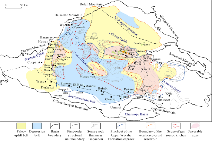
Fig. 5.
Comprehensive evaluation map of favorable zones for searching Carboniferous natural gas in the Junggar Basin.
Based on a comprehensive analysis of source rocks, reservoir-caprock configuration, paleouplift background and late fault damages, in combination with the current exploration results, four favorable zones, the Dinan Uplift belt, Eastern Uplift belt, Zhongguai Uplift belt and Mosuowan Uplift belt have been made out as the key target areas for searching large and medium-sized Carboniferous gas fields (reservoirs) (Fig. 5).
4.2. The lower assemblage in the southern margin of the Junggar Basin
The foreland thrust belt in the southern margin of the Junggar Basin covers an area of about 2.3×10⁴ km2. The natural gas geological resources and remaining gas resources of the area were estimated at 9800×108 m3 and 9454×108 m3 in the fourth time of resource evaluation. This area has 3 reservoir-cap assemblages, but the exploration work and hydro-carbon discoveries before were mainly concentrated in the middle and upper assemblages, while the lower assemblage is low in exploration degree, with no major breakthrough so far. Based on a comprehensive analysis, there are three favorable conditions for gas accumulation in the lower assemblage in the southern margin of the Junggar Basin.
Firstly the structural formation of the lower assemblage in this area is relatively well preserved, which is conductive to the formation of large and medium-sized gas fields. Under the control of two sets of regional mudstone caprocks of the Anjihaihe Formation and Tugulu Group, three sets of (the upper, middle and lower) structural layers and reservoir assemblages develop in the southern margin of the Junggar Basin. The upper structural layer includes the strata above the Anjihaihe Formation, which has source rocks of the Jurassic, Cretaceous and Tertiary, and the Taxihe Formation mudstone and Shawan Formation sandstone constituting good reservoir-caprock assemblage, forming the upper source-reservoir-caprock assemblage. The upper reservoir assemblage has shallow buried depth, poor sealing capacity of the mudstone caprock, and serious damage caused structural deformation, so the natural gas in it is difficult to preserve. The middle structural layer includes the strata between the Anjihaihe Formation and Tugulu Group, which has the Jurassic and Cretaceous source rocks, the mudstone of the Anjihaihe Formation as caprock, and the sandstone of Donggou Formation as reservoir, forming the middle source-reservoir-caprock assemblage. Deeper in buried depth, the middle reservoir assemblage has better sealing capacity of mudstone caprock and better integrity of the lower structure, so medium sized gas fields are likely to occur in this assemblage. The lower structural layer includes the strata below the Cretaceous Tugulu Group, which has the Jurassic source rock, the Tugulu Group mudstone as caprock and the Toutunhe Formation sandstone as reservoir, forming the lower reservoir assemblage. The lower reservoir assemblage has deep buried depth, so its mudstone caprock has high sealing capacity, and its structures are complete, making it possible for large and medium-sized gas fields (reservoirs) to form.
Secondly, there are several sets of effective clastic reservoirs developed in the lower assemblage at the southern margin of the Junggar Basin, which provide the reservoir conditions for forming large and medium-sized gas fields (reservoirs). There are three sets of large-scale clastic reservoirs, the Qingshuihe Formation (K1q), Kalazha Formation (J3k) and Toutunhe Formation (J2t) below the mudstone of the Cretaceous Tugulu Group[34], of which the buried depth of the main structure is shallower. The Cretaceous Qingshuhe Formation is a set of thick massive conglomerate and sandstone (40-80 m thick), in the main structure, the reservoir of the Qingshuihe Formation is at the buried depth of 6000-6500 m. The Jurassic Kalazha Formation is a set of thick massive sandstone and conglomerate (200-600 m thick). In the main structural belt, the reservoir of the Kalazha Formation is at the buried depth of 6500-7000 m. The Jurassic Toutunhe Formation is a set of interbedded sandstone (50-280 m thick). In the main structural belt, the reservoir of the Toutunhe Formation is at the buried depth of over 7000 m. According to the relationship between porosity and depth of the reservoirs in the southern margin and adjacent regions of the Junggar Basin, it is inferred that the reservoirs at 6000-7000 m depth in the Wugui structural belt of the main part of the southern margin have a porosity range from 5% to 10% (Fig. 6)[35], which has reached the standard of effective reservoir for deep natural gas accumulation. In addition, the Well Xihu1 drilled there encountered 201m-thick medium-fine sandstone in the interval of 5970-6171 m of the Toutunhe Formation, which has a measured porosity range of 7%-10% and an average porosity of 8%, verifying the reliability of the porosity-permeability prediction model mentioned above. In the formation test after fracturing, the intervals of 5996-6018 m and 6139-6160 m in this well produced 50.29 m3/d and 55.3 m3/d of water respectively and a small amount of oil, proving that large-scale effective reservoirs still exist in the main structure of the lower assemblage at the southern margin at the buried depth of 6000-7000 m, which provide storage conditions for large-scale natural gas accumulation.
Fig. 6.
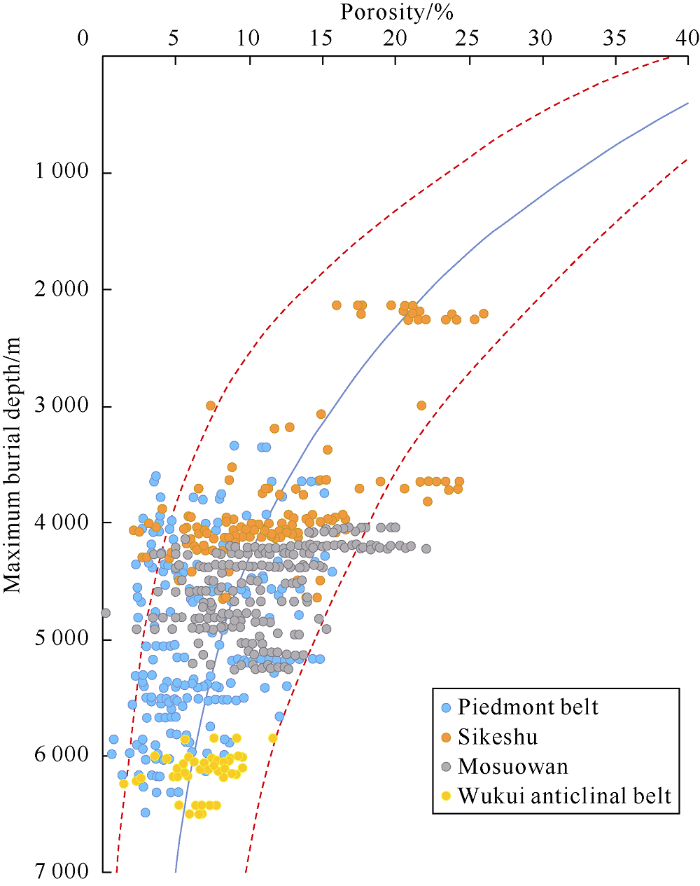
Fig. 6.
The relationship between porosity and depth of reservoirs in the Southern margin of Junggar Basin after denudation recovery.
Thirdly, the central-eastern segment of the second row of structure in the lower assemblage at the southern margin of Junggar Basin has the best trap-source configuration both in time and space, which is a key target for breakthrough. In this area, three rows of structural belts turn up successively from the piedmont to the basin (Fig. 7). The first row is the Qigu piedmont fault-fold belt, where the structural traps were formed approximately 150 Ma ago. The second row is the Huoma structural belt, where the structural traps were formed 8-10 Ma ago. The third row is the Dushanzi-Anjihai-Hutubi structural belt, where the structural traps were formed approximately 2.58 Ma ago[36]. The coal measure source rocks of the Middle-Lower Jurassic generate gas primarily, of which, the source rock of the Badaowan Formation (J1b) reached gas generation peak at 140 Ma-65 Ma, and the source rock of the Xishanyao Formation (J2x) reached gas generation peak at 22 Ma-6 Ma[37]. From the perspective of the matching relationship between the structure forming time and the hydrocarbon generation peak, the traps in the first and second rows of structural belts formed earlier match with the hydrocarbon generation peak better, while the traps in the third row of structural belt formed after the hydrocarbon generation peaks of the two sets of the main source rocks, so they don’t match well with the hydrocarbon generation peaks. Due to strong structural compression of the piedmont belt, the first row of structural belt is badly fragmented and thus has poor preservation condition unfavorable for gas accumulation. Therefore, the second row of structural belt has the best trap-source configuration in time and space and best preservation conditions, so it is the most favorable structural belt. Meanwhile, since the Mesozoic, the depocenter of the southern margin of Junggar Basin has been located in the central-eastern segment, the source rocks deposited before were buried deep in foreland thrust belt of the Late Himalayan period, and the source rocks of the Middle-Lower Jurassic are buried at the depths of 6000-8000 m and have reached mature-overmature stage. The main gas-generating center is located in the central-eastern segment of the southern margin of Junggar Basin. The results of the fourth resource assessment show that this segment has natural gas geological resources of 9738×108 m3, accounting for 99% of the total resources of the entire southern margin of Junggar Basin, of which the natural gas geological resources of the lower assemblage are 7608×108 m3, accounting for 78% of the total resources. Therefore, from resource potential and matching conditions of accumulation, the lower assemblage of the central-eastern segment in the second row of structural belt has the best gas accumulation conditions, and thus is the key direction of natural gas exploration in the southern margin[38].
Fig. 7.
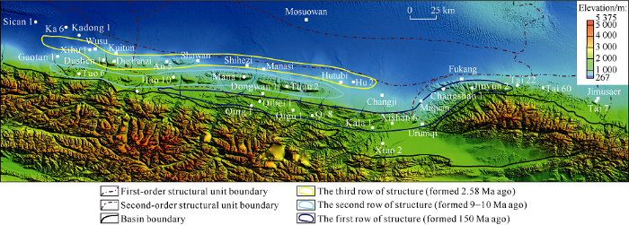
Fig. 7.
Distribution and formation time of three rows of structural belts in the southern margin of Junggar Basin.
In the lower assemblage of the central-eastern segment in the southern Junggar are seven large structural traps, including Tugulu, Manasi and Huoerguosi etc, with a trap area of 19.2- 211.5 km2 each, and a total area of 788.2 km2. They have high point buried depths of 3200-7200 m and potential trap resources of 4250×108 m3, and can form large natural gas fields (reservoirs), so they are the key targets for future gas exploration.
4.3. Central Depression belt
The Central Depression belt is located in the center of the basin, with an area of 3.81×10⁴ km2. It is composed of five secondary sags, Mahu, Pen1 West, Shawan, Fukang and Dongdaohaizi, where there are multiple sets of source rocks, including the Carboniferous, Permian and Jurassic. The source rocks are buried deep at 5000-10 000 m generally, and up to 15 000 m. The Permian Fengcheng Formation and the Lower Wuerhe Formation are two major sets of source rocks, which are widely distributed in the Central Depression belt. The source rocks of the Permian have been encountered in the Mahu sag and its peripheral areas. The source rock of the Fengcheng Formation has an average TOC of 1.38%, average S1 + S2 of 4.96mg/g, TypeⅠ-Ⅱkerogens and a measured Ro range of 0.56%-3.95%. The source rock of the Lower Wuerhe Formation has an average TOC of 1.99%, average S1+S2 of 2.68 mg/g, TypeⅡ-Ⅲ kerogens and a measured Ro range of 0.54%-2.28%. The simulation of hydrocarbon generation shows that the source rock of the Fengcheng Formation generates largely oil, and a small amount of natural gas when reaching Ro of greater than 2%[39]. The source rock of the Lower Wuerhe Formation generates oil in the early stage and gas in the late stage, reaches the oil-generating peak at Ro of greater than 1%, and begins to generate large amount of gas when reaching Ro of greater than 2%. The source rock of the Lower Wuerhe Formation has a gas-generation intensity of (5-160)×108 m3/km2, and the area with the gas-generation intensity greater than 20×108 m3/km2 of 1.5×10⁴ km2. The natural gas geological resources of the Central Depression were estimated at 8351×108 m3 in the third resource assessment, which indicates that the Central Depression belt possesses the resource base for natural gas accumulation [40].
There are two types of exploration targets developed in the Central Depression belt, the deep large structural targets and the large stratigraphic-lithological targets. The deep large structural targets mainly include seven large anticlinal traps of Mahu, Manan, Mabei, Well area Da1, etc., where the target strata are in the Carboniferous-Permian, with the trap area of 1784 km2, and the two accumulation modes are late-generation ancient-reservoir and self-generation self-reservoir. With resources of 6000×108 m3, Mabei and Manan anticlinal traps are the key exploration targets in the deep formations of the Central Depression belt. Stratigraphic-lithological traps are mainly distributed in the Triassic-Cretaceous, including Zhongguai Uplift faulted-lithological trap group and Shixi nose uplift faulted-lithological trap group, with a total area of 5369 km2. Through migration along faults, the oil and gas generated by the source rock of the Lower Wuerhe Formation would accumulate in large stratigraphic-lithological traps. With potential resources of 5000×108 m3, these are the key exploration fields of both oil and gas[41,42].
5. Conclusions
The “more oil and less gas” phenomenon in the Junggar Basin does not match with the actual geological conditions of the natural gas. From the perspectives of gas source rocks, reservoirs and caprocks, the basin has geological conditions for forming large and medium-sized gas fields (reservoirs). The basin has three favorable exploration directions of large and medium-sized gas fields (reservoirs), the Carboniferous volcanic rock, the lower assemblages of the southern margin and the Central Depression belt.
The gas accumulation in the Carboniferous volcanic rocks is mainly controlled by the palaeo-uplift background, gas source kitchens and high-quality reservoir-caprock assemblages. The comprehensive evaluation shows that the Diannan Uplift belt, Eastern Uplift belt, Zhongguai Uplift belt and Mosuowan Uplift belt are favorable exploration areas.
The gas accumulation in the lower assemblage at the southern margin is mainly controlled by the Jurassic highly- mature gas source kitchens, overpressured mudstone caprocks and trap-source matching conditions. The seven large structural traps, Tugulu, Manasi and Huoerguosi etc. in the lower assemblage of the central-eastern segment of the southern margin are the most favorable exploration targets.
The gas accumulation in the central depression belt is mainly controlled by deep traps and reservoir conditions, and the deep large structures in Mabei and Manan and the Zhongguai and Shixi nose structural-lithological targets are favorable exploration targets.
Reference
Geochemical characteristics and the origin of natural gas in Carboniferous, eastern Junggar Basin
DOI:10.11764/j.issn.1672-1926.2015.S2.0148
URL
[Cited within: 1]

The Carboniferous “self-generation and self-preservation” gas in eastern Junggar Basin was characterized by late accumulation from multiple sets of source rocks and depressions.The analyses of gas composition and isotopes were performed to trace the isotopic and organic facies of the possible source rocks,and to determine the origin of natural gas in Carboniferous,as well as gas-source correlation in eastern Junggar Basin.All the gas samples from Ludong area are coal-derived gas,and most of them are dry gas,while the gas samples from Wucaiwan area are mixed gas,mixing of coal-derived gas and condensate associated gas,belonging to wet gas.The carbon isotopic distribution of most samples from both Ludong and Wucaiwan is characterized by positive carbon sequence among C1,C2,C3 and C4 alkanes.The carbon isotopes for samples from Ludong area are heavier than samples from Wucanwan area,and carbon isotope of ethane is generally enriched in 13C.The differences of organic matter types and the temporal and spatial distributions between Dishuiquan Formation in Lower Carboniferous and Batamayineishan Formation in Upper Carboninerous in the eastern Junggar Basin caused the samples from Wucaiwan area with lighter carbon isotope and condensate associated gas.The source rocks of Dishuiquan Formation deposited in restricted sea were only developed in Wucaiwan area during the Early Carboniferous,and the source rocks from Batamayineishan Formation were characterized by salty water lake,which were widely distributed in the various continental faulted depression in Ludong and Wucaiwan area.Hence,gases in Ludong area are mainly from Batamayineishan Formation in Dishuiquan Sag,while gases for Wucanwan area are from Batamayineishan Formation and Dishuiquan Formation in Wucaiwan Sag.
Origins of the natural gas and its migration and accumulation pathways in the Kelameili Gas Field
DOI:10.11764/j.issn.16721926.2016.02.0268
URL
[Cited within: 1]

The Kelameili natural gas field is the only gas reservoir that developed in the volcanic reservoir in the Junggar Basin,northwest China.Geochemical characteristics indicate that the natural gas was sourced from type Ⅲ kerogen developed in the Wucaiwan Sag to the east and the Dishuiquan Sag to the west,respectively.The maturity of the natural gas from the Dishuiquan Sag was lower than that from the Wucaiwan Sag.Lateral variation of the composition,maturity,and isotopes of the natural gas indicate that the main pathway system for the natural gas lateral migration is the EWstriking fault that developed in this district.Natural gas from the Dishuiquan Sag migrates eastward and that from the Wucaiwan migrates westward.Mixing happened at well DX18 district and isotope reversal was observed in this district.Research indicates that fissure and fracture due to latestage tectonic faulting have enhanced the capability of the reservoir.The permeability of the reservoir has enhanced 23 orders higher than that of the background,which in turn makes the faults to be the best hydrocarbon migration pathway systems.The above recognized hydrocarbon migration pathway systems indicate that the hydrocarbon exploration should focus on the traps that have been linked by the faults with the source kitchens.
Sources and distribution patterns of natural gas of different genetic types at the northwestern margin of the Junggar Basin
Genetic types and distribution regularity of natural gas in northwest margin of Junggar Basin
Differences between oil and gas accumulations in Zhongguai, 5th & 8th Districts of Karamay Oil Field, northwestern marginof Junggar Basin
Characteristics of natural gas and rules of hydrocarbon accumulation in the northwest margin of Junggar Basin
Analyses of the genesis and potential of natural gas in Kebai Area of northwest margin, Jungar Basin
Identification of natural gas types and analysis on its distribution rules in Permian in Block No.5 to 8 of northwest margin of Jungar Basin
Genetic type and source of natural gas in the southern margin of Junggar Basin, NW China
Prototype and tectonic evolution of the Junggar Basin, northwestern China
Types and tectonic evolution of Junger Basin
The depositional environment of Permian hydrocarbon source rocks and its potential hydrocarbon generating characteristics in major basins in north Xinjiang
Comparisions of geochemical characteristics of Carboniferous and Permian main source rocks in Junggar Basin
The thermal history of Junggar Basin
Comparative reserach on tectonical thermal history of sedimentary basins in the north China
Tectono thermal evolution in the Junggar Basin
Thermal evaluation and hydrocarbon generation history of the sedimentary basins in western China
Simulation of geothermal evolution history in Junggar Basin
Sealing capacity of the Tugulu Group and its significance for hydrocarbon accumulation in the lower play in the southern Junggar Basin northwest China
Pressure seals: Their diagenetic banding patterns
DOI:10.1016/0012-8252(90)90039-X URL [Cited within: 2]
Pressure sealing: An important agent for hydrocarbon entrapment
DOI:10.1016/0920-4105(93)90029-E URL [Cited within: 1]
Pressure cells and pressure seals in the UK Central Graben
DOI:10.1016/S0264-8172(96)00023-2 URL [Cited within: 1]
Brittle ductile deformation characteristics of anhydrite salt rock in Kuqa Depression and quantitative evaluation of its sealing ability
Brittle ductile deformation characteristics of anhydrite salt rock and quantitative evaluation of its sealing ability
Controlling factors of weathering volcanic reservoir: An example from the Carboniferous Kalagang Formation in Santanghu Basin
Weathered volcanic crust and its petroleum geologic significance: A case study of the Carboniferous volcanic crust in northern Xinjiang
Recent progress and prospect of oil and gas exploration by PetroChina Company Limited
The types of source-reservoir-seal combination of natural gas fields and exploration significance in Junggar Basin
Carboniferous tectonic framework and sedimentary filling evolution in the Junggar Basin and adjacent area, NW China
Geochemical characteristics and tectonic settings of Carboniferous volcanic rocks from Junggar Basin, China
Post-collisional tectono-magmatism and its constraint on volcanic reservoirs around Kalamaili suture zone in north Xinjiang
Palaeogeographic characteristics and basic geological conditions of petroleum of the Carboniferous in Junggar Basin and its adjacent areas
DOI:10.7605/gdlxb.2014.05.53
URL
[Cited within: 1]
It has the double basement of the Precambrian metamorphic crystallization basement and fold basement in Junggar Basin and its adjacent areas. The Carboniferous was the first full strata and developed well in the study area. Under the instruction that the tectonic controls a basinsdevelopment, while the latter controls facies, the sedimentary facies and lithofacies palaeogeographic characteristics in the study area was analyzed as follows: during theEarly Carboniferous, the sedimentary basins, with active or passive continental marginal marine facies or land-ocean transitional facies,were formed; while in Late Carboniferous, the sedimentary basins of land-ocean transitional facies and the continental volcanic build-ups were developed. Generally, the Carboniferous was divided into three zones of marine, land-ocean transitional, and continental facies; detailedly, 8 types of facies were identified, i.e., continental, marine volcanic and pyroclastic, bathyal-abyssal, neritic, littoral, deltaic, fluvial- lacustrine, and the alluvial-fan facies. Based on the idea that “the sedimentary facies controls the basic geological conditions of petroleum”, the petroleum distribution in Junggar Basin is concluded as: (1) For the Karamay-Baijiantan areas in the northwestern margin, and the Bayingou and Urumqi in the southern margin, it develops bathyal-abyssal dark muddy shales, which are supposed to be relatively good source rocks; (2)The delta facies which are favorable developed in the southeast-northern margin of Junggar Basin, such as the areas of Karamay are the advantageous zone of oil and gas exploration, and the source rocks and reservoir rocks were developed well. (3) The tidal-flat facies and lagoon facies which are favorably developed in the Santanghu area, as well as the neritic carbonate- clastic shelf facies which are favorably developed in the Burerjin-Fuyun and Bogeda mountain areas can form arelatively good assemblage of source-reservoir-cap. These sedimentary facies and zones where source, reservoir and cap rocks distributed trinity are the optimum targets and the top choice areas.
Characteristics and exploration potential of Carboniferous hydrocarbon plays in Junggar Basin
Hydrocarbon reservoirs and their controlling factors in the lower associations of the middle part of southern Junggar Basin, Xinjiang
Reservoir porosity evolution characteristics and evaluation of the slope belt in the southern margin of the Junggar Basin: Insight from digenesis modeling experiments
Structural geology correlation of foreland thrust-folded belts between the southern and northern edges of the Tianshan Mountain and some suggestions for hydrocarbon exploration
The southern margin of Junggar Basin hydrocarbon source rock thermal evolution history of hydrocarbon generation and oil and gas source analysis
Strategic breakthrough in Gaoquan anticline and exploration assessment on lower assemblage in the southern margin of Junggar Basin
Fengcheng alkaline lacustrine source rocks of lower Permian in Mahu Sag in Junggar Basin: Hydrocarbon generation mechanism and petroleum resources reestimation
The deep structural features and hydrocarbon prospect in hinterland of Junggar Basin
Effective reservoirs and hydrocarbon phases in discordogenic in Mahu sag and its periphery in Junggar Basin
An analysis on the process of hydrocarbon accumulation in the central depression belt of the Junggar Basin
