


Introduction
Carbonate formations in Tarim Basin, NW China, contain rich oil and gas resources. The proven reserves in Tarim oilfield reaches 1108 million tons, among which more than 90% comes from fractured-vuggy carbonate reservoirs[1,2,3,4,5,6]. The HA 6, Xinken, Repu and Jinyue blocks in the north of the Tarim river have been explored and developed successively in Halahatang oilfield. As the exploration goes from buried hill area, along- bedding reformation area and then to platform margin superimposing reformation area, the basic geological understandings and key technology series on fractured-vuggy carbonate reservoirs have been formed. With the improvement of seismic data quality and drilling technology, the scope of exploration and development in Halahatang oilfield is expanding southward, and major breakthroughs have been made successively in deep and super-deep (6500-7500 m) carbonate reservoirs in recent years. Lots of wells produced hundreds of tons of oil daily in the areas of Yueman, Fuyuan and Yuke and other new districts of Yuemanxi, Guole and Luchang have been found consecutively. Now the South-Tahe area of Halahatang oilfield with a production capacity of nearly one million tons is constructed, and has become the key area of carbonate exploration and development in the Tarim Basin[7,8]. By now, the area with oil discovery has reached 5041 km2, and oil reserves controlled by 18 deep faults have amounted to more than 163 million tons. According to the “14th Five-Year Plan”, the region, as a major oil and gas development battlefield, will have a production capacity of 1.5 million tons of crude oil and 660 million cubic meters of natural gas constructed in 2022.
Just like the South-Tahe area of Halahatang oilfield, the productivity construction project are promoting steadily and fast in the neighboring area, ShunBei. The definition of fault-karst carbonate reservoir was first proposed by LU, aimed to develop these reservoirs of ShunBei district in Tahe oilfield[9]. He pointed out that the main deep-large faults belts formed by the tectonic forces were corroded by the meteoric water or hydrothermal liquid and thus formed the fault-karst bodies composed of big caves, holes and fractures. These fault-karst bodies formed fault-karst reservoirs after capturing hydrocarbon with the sealing by thick muddy-limestone above or dense limestone around. With the help of production practice, the understanding of carbonate fault-karst reservoirs is deepening. The recognition of carbonate reservoir in Halahatang oilfield has changed from fractured-vuggy reservoirs to fault-karst reservoirs controlled by the main deep-large faults which control not only the forming of reserving bodies, but also the hydrocarbon accumulation and enrichment.
Based on comprehensive analysis of tectonic and fault evolution, core, well logging, seismic, drilling, and production data, the reservoir space characteristics, distribution, geologic formation of fault-karst carbonate reservoirs in the South-Tahe area of Halahatang oilfield, Tarim Basin, were studied systematically. Further, the pattern of hydrocarbon accumulation and enrichment were analyzed systematically based on development practice of the reservoirs to provide a reference for efficient exploration and development of such similar reservoirs.
1. Geological background
The Halahatang oilfield is located in the west slope of Lunnan low uplift of the Tabei uplift in Tarim Basin. Adjacent to Luntai uplift on the north, Amman transition zone on the south, and Yingmaili low uplift on the west, it is an important part of Lungu-Tahe-Halahatang huge Ordovician oilfield undergoing multiple tectonic movements and sedimentary evolution. The research area in this work is South-Tarim area of Halahatang oilfield. Close to the Shunbei oilfield, surrounded by the two main hydrocarbon-generation sags, Manjiaer and Awati etc., it is a favorable block for oil and gas migration and accumulation (Fig. 1).
Fig. 1.
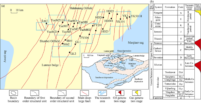
Fig. 1.
Distribution of structures and main deep-large faults in the South-Tahe area (a) and columnar section of strata and reservoir-forming stages in the Tarim Basin (b).
In early Caledonian (Cambrian-Middle Ordovician), carbonate platform and marine argillaceous source rock deposited in the South-Tahe area of Halahatang, and the large Manxi carbonate platform developed in the Tazhong-Tabei area. After multiple stages and cycles of unconformity and meteoric water leaching, Yingshan Formation (O1-2y)-Yijianfang Formation (O2y) carbonate reservoirs were formed widely in this area. At the same time, a set of Cambrian-Middle Ordovician source rock developed in the Manjiaer sag in the east of South-Tahe area[10], providing material basis for the migration and filling of oil and gas.
TheⅠ-Ⅱepisode of Middle Caledonian was an important period of transformation of tectonic-sedimentary nature, when the southern Tianshan ocean subduction became stronger, Tabei structure uplifted as a whole, and the palaeohighs formed basically. Under the compression of NE and NS bidirectional in-situ stresses, strike-slip fault systems trending NE and NW came up in large area, forming the frame of fault systems in this area, and laying foundation for the formation of fault-karst bodies later. The strike-slip faults are nearly vertical or in positive flower structure, which extend downward to the interior of the Cambrian or even through the Cambrian and upward to the top of the Lianglitage Formation (O3l) deposited during this period. On the plane, these strike-slip faults are mostly linear, extending to tens or even hundreds of kilometers, and appear in echelon or feather arrangement in local part. In the Ⅲ episode of the Middle Caledonian movement, due to the effect of global transgression, carbonate platform deposition ended and mixed shelf deposition started in this area. The Sangtamu muddy formation of 600-700 m thick was formed, providing a high-quality regional caprock for the Ordovician carbonate reservoirs.
From Late Caledonian to Early Hercynian (Silurian-Devonian), under the effect of collision between the middle Kunlun island arc, the middle Kunlun terrene and the strong compression of the Altyn orogenic belt[11,12], the Tabei uplift underwent three times of strong uplifting before the deposition of the Silurian, Devonian, and Carboniferous. The Luntai uplift and Lunnan low uplift also continuously uplifted, the Halahatang and Hadson nose structures were formed successively, and the Tabei palaeohigh basically finalized in shape. During this period, the NE and NW-trending faults developed successively, cutting down to the Cambrian to communicate with the high-quality source rock at the bottom of the Cambrian and reaching up to the Middle-Lower Devonian. The fault belts continued to extend and deform, forming fault fracture zones, and the carbonate reservoirs along the fault zones expanded in scale.
In the Middle-Late Hercynian (Carboniferous-Permian), the south Tianshan ocean closed like scissors from east to west, the Tabei uplift tectonic movement extended from east to west, stronger in the west and weaker in the east, and the Ordovician structure in Halahatang area was relatively stable. The successive activity of early strike-slip faults occurred because of the Permian volcanic eruption and the carbonate reservoirs along the deep and large fault belts were dissolved by high-temperature thermal fluid rich in silicon.
During the Indosinan-Yanshanian (Triassic-Cretaceous), the faulting activity was relatively weak and the whole south margin in Tabei was relatively stable. During the Himalayan movement, the Mesozoic and Cenozoic in the Halahatang area generally tilted to the north, while the Lower Paleozoic remained dipping to the south; and the structural model of nose-shaped uplift at present finalized.
2. Fault-karst bodies
2.1. Types of storage space
The Ordovician carbonate reservoirs in the South-Tahe area mainly developed in the Yijianfang (O2y)-Yingshan Formation (O1-2y). There are many types of storage space, including cave, dissolved pore and vug (Fig. 2a, 2d), high-angle structural fracture (Fig. 2b, 2c, 2f), enlarged or filled residual fracture, intercrystalline pore (Fig. 2e), intergranular pore and micro-fracture etc.
Fig. 2.

Fig. 2.
Characteristics of Ordovician carbonate storage space in the South-Tahe area of the Tarim Basin. (a) Well HD27, 6285.5 m, O2y, light gray arenaceous limestone, with micro-fractures and unfilled cave, core photo; (b) Well Yuke1, 6699.0 m, O2y, a core photo with suture lines and dissolved pores and vugs filled with asphalt; (c) Well HD25, 6498.0 m, O2y, a cast slice of sparry conglomeratic limestone with fractures and intragranular dissolved pores; (d) Well HD27, 6291.0 m, O2y, a core photo shows filler in cave with asphalt; (e) Well YueM22, 7342.4 m, O2y, a cast slice shows a few intergranular and intragranular pores; (f) Well Yuke101, 6498.0-6503.0 m, an imaging logging picture shows high conductivity fractures. (g) Well Yuke201, 6717.0-6719.0 m, an imaging logging picture shows caves and vugs.
The different types of storage space differ widely in size. The large caves can range from several meters to tens of meters, and engineering anomalies such as drilling break and drilling fluid leakage etc. often occur when drilling into them. They are often shown as dark spots in imaging logging (Fig. 2g). The dissolved pores and vugs range from several centimeters to tens of centimeters, while the intercrystalline and intergranular pores are only several millimeters in size. The major storage space is composed of caves, dissolved pores and vugs and structural fractures, and they are also important flowing channels; whereas the intercrystalline pores, inter-granular pores and micro-fractures contribute little to storage and seepage.
CT scan results show the cores of Ordovician carbonate have an average porosity of 2.1% and average permeability of 0.33×10⁻³ μm2; the logging interpretation results show that the carbonate reservoirs have an average porosity of 3.6% and average permeability of 0.56×10⁻³ μm2; the interpretation of well test data shows the carbonate reservoirs have a permeability of (550-3000)×10-3 μm2, which show a wide difference. In fact, the static data cannot reflect the true storage and seepage capacity of the reservoir, because the reservoir cores cannot be easily collected due to the caves or big fractures developed around wellbore. And the real storage space may be cave-vuggy bodies related to fault zone.
2.2. Spatial distribution
The Ordovician fault-karst bodies of the South-Tahe area are mainly distributed along the main fault belts. For example, more than 80% of the high production wells out of the 15 wells deployed along the YueMan 3 fault belt showed drilling break and drilling fluid leakage when drilling to the target zone. Well YueM3-5 drilled into the secondary fault zone more than 800 m from the main fault zone had no drilling break or drilling fluid leakage with weak gas shows. Conventional logging interpretation showed the reservoirs in this well were mainly type Ⅲ, and imaging logging showed just a few high angle fractures. During formation testing, the well had liquid supply too low to put into production. Later, the well was sidetracked 500 m toward to the main fault to obtain high yield industrial oil flow of up to 60 t/d.
2.2.1. Plane distribution
The Ordovician fault-karst bodies in the South-Tahe area are in band distribution along the fault zones on the plane. But the fault-karst bodies differ widely in development degree in different segments of the same fault belt, which is related to the segmentation of strike-slip fault. According to the state of stress, the strike-slip fault can be divided into three types: tension section, extrusion section and translation section. The tension section and extrusion section occur in stress-releasing bending position and stress-limiting bending position respectively, while the translation section occurs in relatively stable stress position[13,14,15,16]. For the same fault, the tension section is most developed, followed by extrusion section, and translation section is the worst. Olson et al.[17,18] pointed out that the degree of formation fragmentation controlled by the fault was mainly affected by the strain energy density around the fault system. Generally, the strain energy density at the end of the fault is the strongest, so the formation there is with the highest degree of fragmentation. Large rock-bridge fracture zone (pull-apart graben) is likely to occur at the place where faults overlap and pull apart. The rock-bridge area where two main faults intersect and overlap is stretched along the fault strike is more conducive to the reservoir dissolution reformation. And it is often manifested as a negative flower-like structure with developed positive fault or small extensional fractures (Fig. 3a). But in the position of overlapping compression and torsion, the structure is characterized by positive flower shape with dense thrusting or small shear fractures, where the fault-karst bodies are relatively poor due to the limitation of stress (Fig. 3b). In the translation section where the two walls of fault mainly slide against each other and secondary fractures only intersecting in small angle with the main deformation zone come up in the surrounding rock of the two walls of the fault, fault-karst bodies are poorly developed.
Fig. 3.
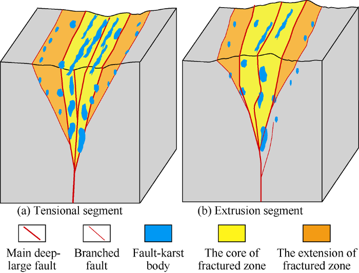
Fig. 3.
Schematic diagram of fault-karst reservoirs in South- Tahe area.
For example, the YueMan 2 fault belt is 29 km long in total. According to stress analysis, it is divided into nine segments, including three tensional segments, four extrusion segments and two translation segments (Fig. 4, Table 1). The tensional segments are 10.5 km long in total and 0.23-1.95 km wide, where the fault-karst bodies are large in scale. Eight wells drilled in these segments have an average single well controlled geological reserves of 82×104 t, initial average single well productivity of 61 t/d and average cumulative output per unit pressure drop of 1796 t/MPa, showing that the formation energy is sufficient or fairly sufficient. The extrusion segments are 12.5 km long in total, and 0.15-1.71 km in fault width, where the fault-karst bodies are moderate in scale. Seven wells drilled in these segments have an average single well controlled geological reserves of 53×104 t, average initial single well productivity of 39 t/d and an average cumulative output per unit pressure drop of 718 t/MPa, showing that the formation energy is fairly sufficient or insufficient. The translation segments are 6 km long in total and 0.12-0.56 km in fault width. Three wells drilled in these segments have average controlled single well geological reserves of 25×104 t, an average initial single well productivity of 23 t/d and an average cumulative output per unit pressure drop of 238 t/MPa, showing that the formation energy is insufficient and production declines rapidly.
Fig. 4.

Fig. 4.
Planar distribution of fault-karst reservoirs in Yueman block of the South-Tahe area.
Table 1 Statistics on development effects of different segments of Yueman 2 fault belt in the South-Tahe area.
| Segement ID | Fault nature | Stress intensity | Fault length/km | Fault width/km | Geologic reserves/104 t | Number of wells | Initial productivity/(t·d-1) | Average cumulative output per unit pressure drop/(t·MPa-1) | Formation energy |
|---|---|---|---|---|---|---|---|---|---|
| 2-1 | Translation | 4.1 | 0.12-0.56 | 50 | 2 | 25 | 250 | Weak | |
| 2-2 | Extrusion | Weak | 4.6 | 0.15-0.63 | 45 | 1 | 36 | 610 | Insufficient |
| 2-3 | Tension | Strong | 3.9 | 0.74-1.95 | 284 | 3 | 68 | 2 232 | Sufficient |
| 2-4 | Tension | Strong | 3.8 | 0.61-1.85 | 165 | 2 | 62 | 1 805 | Sufficient |
| 2-5 | Extrusion | Strong | 2.3 | 0.59-1.68 | 116 | 2 | 43 | 812 | Fairly sufficient |
| 2-6 | Extrusion | Weak | 2.5 | 0.14-0.69 | 88 | 2 | 32 | 600 | Insufficient |
| 2-7 | Translation | 1.9 | 0.15-0.41 | 26 | 1 | 20 | 226 | Weak | |
| 2-8 | Tension | Weak | 2.8 | 0.23-0.72 | 209 | 3 | 55 | 1 351 | Fairly sufficient |
| 2-9 | Extrusion | Strong | 3.1 | 0.55-1.71 | 120 | 2 | 45 | 850 | Fairly sufficient |
2.2.2. Vertical distribution
The first feature of fault-karst bodies in vertical direction is their irregularity. The fault-karst body is divided into core part and extension part. Due to fragmented faults and strong dissolution, the core part has large fracture-vug bodies developed and reservoir of larger scale, so it is the main target of drilling. The extension part has mainly small scale fracture-pore bodies developed due to associated faults (Fig. 3). The second feature is that the reservoirs developed in different depths and layers. Fig. 5a shows the distribution of drilling break and leak points during drilling of wells in Yueman block. It can be seen from the figure that the reservoirs in different wells are at different distances from a few meters to 120 m (on average 70 m) from the O2y top limestone. In most wells, large fracture-vug bodies are encountered less than 70 m down from the O2y top. In addition, this can also be seen from the "bead" reflection position on the seismic section of Yueman block (Fig. 5b). Moreover, the reservoirs may extend several hundred meters vertically through the O2y and O1-2y. For example, Well YueM5 revealed 20 m of the O2y and had a drilling break of 1.2 m. After completion, it had an initial daily production of 120 t during test. In 3 years of production, it has remained stable in tubing pressure and production and has dynamic reserves of up to 3 million tons. At present, its bottom hole flow temperature is 7.2 °C higher than the initial stage of production and 7.8 °C higher than the formation static temperature, which indicates that the well has deep fluid supply in the later stage of production. According to the geothermal gradient of 2.4 °C/100 m, the height of oil column is estimated at 325 m.
Fig. 5.

Fig. 5.
The position of fault-karst bodies (a) and the seismic section (b) of Yueman block in the South-Tahe area.
2.3. Genetic mechanism of fault-karst bodies
The Ordovician carbonate fault-karst bodies in the South- Tahe area are mainly controlled by the faults system composed of deep-large faults, associated faults and fractures generated due to Caledonian-Hercynian tectonic movements. And they finalized after superimposed reformation of multi- stage tectonic movements, fault-controlled karstification and local hydrothermal fluid dissolution.
2.3.1. Formation of fault-karst bodies
2.3.1.1. The lithofacies
Lithofacies is the material basis for the reformation of fault-karst body. The sedimentary facies of O2y and O1-2y are mainly open platform and arenaceous oolitic beach at the platform edge. The rocks are mainly sparry arenite bioclastic limestone and sparry oolitic limestone of high energy beach facies at platform edge (Fig. 2c, 2e), which lay a foundation for the later fragmentation and karstification controlled by fault. Intragranular micropores in algalclastic was formed due to the penecontemporaneous erosion of sparry algalclastic limestone. The formations have more than 95% of carbonate rocks and few muddy interlayers. Pure and brittle in lithofacies, they are likely to be broken and corroded later.
2.3.1.2. Fragmentation and dissolution controlled by faults
Fragmentation and dissolution play key roles in the formation of fault-karst body. There are two groups strike-slip faults in NE and NW strikes developed in the South-Tahe area. Among them, the 18 NE deep and large strike-slip faults are mainly single shear faults formed in the Middle Caledonian period. They had been active continuously in the Late Caledonian-Early Hercynian period and moved successively in the Late Hercynian-Indochinese period with high fragmentation degree. There are only 5 NW strike-slip faults. They were formed in the Early Hercynian period, moved successively in Late-Hercynian-Indochinese, and were less fragmented.
Fault fragmentation caused by tectonic movement is the prerequisite for the formation of fault-karst body. According to the Riedel shear physics simulation experiment[17,18], the formation of strike-slip fault zone can be divided into four stages. (1) In the initial stage, the main part of strike-slip fault begins to form, which is distributed in echelon pattern, with a small faulting range and a complete shape of the initiating end. (2) In the early stage, with the increase of stress, its influence scope increases significantly and the fragmentation degree increases rapidly. The strike-slip fault still appears in echelon pattern, but increases apparently in fragmented range and degree. (3) In the middle stage, the fracture range further increases, and the echelon faults connect, giving rise to complete fragmented zone. (4) At the late stage, the fragmentation degree is the strongest, and the whole fragmented zone appears in oblique horsetail shape or feather shape (Fig. 6). The experimental results show that different positions of the same fault belt are different in fragmentation degree. The stress-release bending zone is higher in fragmentation degree while stress-stable zone is lower in fragmentation degree.
Fig. 6.

It is generally believed that the stronger and longer lasting the fault activity is, the more favorable it is to form fault zone. Because the NE faults in this area are more active and lasting longer in active time, they are higher in fragmentation degree. The multi-stage activities and tectonic fragmentation of strike- slip fault also provide smooth channels for the later leaching and dissolution of meteoric fresh water and buried dissolution, creating good conditions for the subsequent formation of large caves, dissolved pores and vugs[19,20,21].
2.3.1.3. Local reformation by deep hydrothermal fluids
The results of temperature measurement of inclusions show that the region has experienced multi-stages of karstification and filling at different temperatures, and the existence of high-temperature inclusions more than 120 °C prove the area may have abnormally high-temperature fluid[20,21]. In addition, siliceous masses and granular pyrite are found commonly in the limestone of Yingshan Formation in Well Shunbei 2 located in the adjacent block next to the southwest of the South-Tahe area, indicating that burial fluid reformation happened and the reservoir formation may be related to burial karstification[21]. Some researchers pointed out that there might be other types of reformation, including dissolutions by basin compaction fluid and acidic fluid carried with hydrocarbon, and sulfate thermochemical reduction etc.[22,23,24,25]. The flow direction of hydrothermal fluid is generally upward along deep and large fault and its reformation degree to reservoir depends on whether the hydrothermal channels are smooth.
2.3.2. Formation pattern of fault-karst bodies
Fault-karst bodies in the South-Tahe area are the product of joint effect of fragmentation, leaching and hydrothermal fluid dissolution in local part controlled by faults. According to the controlling effect of faults, formation patterns of fault-karst bodies can be classified into 3 types, along main deep-large fault, along secondary fault and along secondary internal fault dissolution patterns (Fig. 7).
Fig. 7.
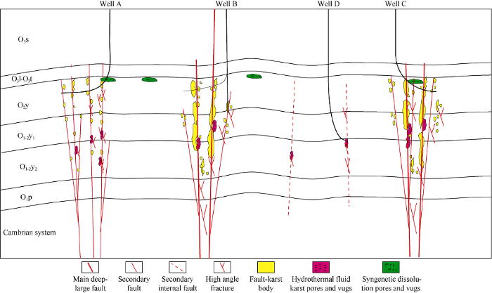
Fig. 7.
Formation patterns of fault-karst bodies in the South-Tahe area.
The pattern along main deep-large fault refers to the formation of fault-karst body controlled by main deep-large fault. These kinds of faults all run through the Cambrian, having strong stress action during formation, and strong breaking effect on limestone. They can create fault fracture zone about 200 m wide in general. The later karstification of meteoric water controlled by fault would further dissolve, enlarge and rebuild the fault fracture zone formed earlier, resulting in opening fluid channels, further increasing of storage space and reformation degree. Subsequently, the meteoric water would enter into a good circulation system and finally lead to formation of large fracture-vug bodies. At the same time, the main deep-large faults are also the dominant channels of hydrothermal fluid, and the deep abnormally high-temperature fluid has a certain reformation effect on reservoir bodies during the process of flowing from bottom to up. The fault-karst bodies formed by this way are composed of large caves, dissolution pores and vugs and fractures. They have excellent planar and longitudinal connectivity, good seepage capacity, and thus are the main drilling targets in the South-Tahe area ( B well and C well in Fig. 7).
The pattern along secondary fault refers to fault-karst body formed under the control of secondary fault. Second to the main deep-large fault in scale, the secondary fault can also extend to the Cambrian formation. But with limited stress effect, they can’t form large scale of fault fracture zones. The fluid flow channels are not as smooth as the deep-large faults, and dissolution and hydrothermal fluid dissolution are less sufficient. The fault-karst bodies formed by this pattern are mainly fracture-pore reservoir composed of dissolution pores, vugs and factures, with connectivity laterally and vertically but limited scale (well A in Fig. 7).
The pattern along secondary internal fault refers to the formation of small scale fault-kart body controlled by secondary internal fault which has no economic development value in general. Secondary internal fault refers to strike-slip fault very small in scale and they can’t reach downwards to the Cambrian and upwards to the Ordovician. With very weak fragmentation effect, this kind of fault can’t form fault fracture zone, and thus is not smooth in fluid flow channel, suffering little meteoric water leaching and very weak reformation by deep hydrothermal fluid, hard to form scale fault-karst body (well D in Fig. 7).
3. Fault-karst reservoirs and hydrocarbon accumulation
3.1. Reservoirs characteristics and distribution
Crude oil of reservoirs in the South-Tahe area is light oil-condensate characterized by low density, low viscosity, and low contents of sulfur, colloid and asphaltene. The surface oil samples have a density range of 0.795-0.877 g/cm3 (0.824 g/cm3 on average), viscosity range at 50 °C of 1.230-5.470 mPa•s (2.375 mPa•s on average), sulfur content range of 0.008%-0.700% (0.200%), and colloid + asphaltene content range of 0.12%-7.71% (1.06% on average). The natural gas produced in this area is mainly hydrocarbon gas, with a methane content of 63.00%-87.50% (73.03% on average), ethane content of 1.13%-30.95% (14.37% on average), and drying coefficient of 75.67%-95.43% (83.74% on average). The natural gas is mainly gas associated with high maturity crude oil and condensate gas, same in origin with the crude oil[6]. The Ordovician reservoirs in the South-Tahe area show the distribution feature of "east gas and west oil". PVT analysis results show that only reservoirs in Yuke district have features of condensate gas reservoir, with gas-oil ratio of more than 5600 m3/m3; while all the rest blocks west of Yuke district shows phase characteristics of weakly volatile light crude oil (Fig. 8).
Fig. 8.
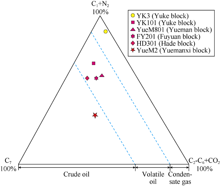
Fig. 8.
The triangle phase diagram of typical wells in the South- Tahe area.
3.2. Hydrocarbon accumulation
3.2.1. High quality source rocks and generation-expulsion conditions of hydrocarbon
The Cambrian source rocks were the main source rock of Ordovician reservoirs in the South-Tahe area. The first stage of oil and gas captured in the South-Tahe area was mainly formed in the late Caledonian period, during which the source rocks in the Manjiaer sag began to generate and expel hydrocarbon. The generated oil and gas began to migrate toward and accumulate in the high parts of the adjacent South-Tahe area. However, due to the strong tectonic movement in the early Hercynian, the oil reservoir was damaged and could not be preserved effectively.
The Manjiaer sag was still in the hydrocarbon generation and expulsion period in the late Hercynian period, when the South-Tahe area captured the second stage of oil and gas in large scale. In this period, a high-quality reservoir-caprock combination of Yijianfang-Sangtamu Formations had been formed with good oil and gas preservation conditions, enabling oil and gas accumulation on a large scale.
In the Indo-Himalayan period, the Manjiaer sag was in a period of dry gas generation and the eastern part of the South- Tahe area was subjected to strong gas invasion, whereas the more westward, the weaker the gas invasion was, giving rise to the model of "east gas and west oil" in South-Tahe area (Fig. 9).
Fig. 9.
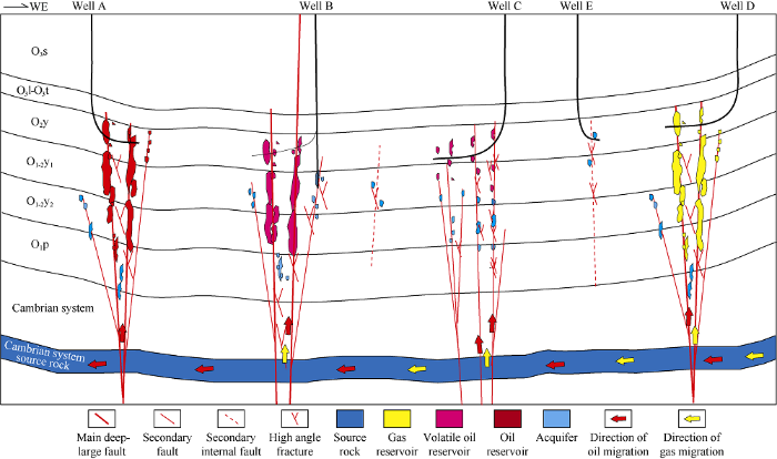
Fig. 9.
Hydrocarbon accumulation mode of fault-karst reservoirs in the South-Tahe area.
3.2.2. Hydrocarbon migration and charging
Several large strike-slip faults in the South-Tahe area cut through the Cambrian. These large strike-slip faults, their concomitant branches and secondary faults constitute a crisscross network system for oil and gas migration. The high mature or over-mature oil and gas provided by the Cambrian hydrocarbon source rock in Manjiaer sag migrated from the southeast to northwest in the South-Tahe area. And they mainly migrated vertically and charged into the fault-karst bodies along the deep-large fault zones, and laterally adjusted to the associated branches and secondary fault zones. Because the fault zones are obviously segmented, the filling degree of hydrocarbon varies greatly. The reservoirs are relatively separated in the lateral and vertical directions and have no uniform oil-water contact (Figs. 3 and 9).
The development practice shows that the main deep-large faults have higher oil and gas charging degree and hydrocarbon enrichment degree. And wells drilled in these fault zones generally produce no water or have longer water free production time. The reservoirs along branch faults aren’t fully charged with oil and gas, so wells drilled in these reservoirs produce both oil and water, which indicates that the formation water hasn’t been fully expelled out during hydrocarbon charging. The internal secondary faults far from the trunk faults have very weak oil and gas charging and poorly-developed reservoirs, so wells drilled in these reservoirs have rapid drop of tubing pressure and water produced during formation test.
The filling degree of oil and gas is related to the activity of fault. The NE faults are more active than the NW faults and are the main migration channels of oil and gas in this region, so the filling strength of oil and gas along the NE faults is high and wells drilled in reservoirs along these faults have higher productivity. In contrast, the NW faults are not active and in a relatively closed state during the oil-gas filling period, and thus are lower in oil and gas filling degree. Due to the difference of stress intensity, different segments of the same fault differ in activity strength and filling strength of oil and gas. Generally, the tensional segment and extrusion segment have stronger oil and gas charging intensity and higher oil and gas enrichment degree.
3.2.3. Hydrocarbon accumulation mode
According to the spatial configuration of the reservoir and caprock, the connectivity between reservoirs, the migration and accumulation strength of oil and gas, the hydrocarbon accumulation models of fault-karst reservoirs can be divided into three categories: the model controlled by main deep-large fault, the model controlled by secondary fault and the model controlled by secondary internal fault (Fig. 9).
The oil and gas reservoir controlled by main deep-large fault refers to the one that has fault-karst body controlled by the main deep-large fault as oil accumulation site, main deep-large fault as migration pathway and the thick Sangtamu Formation mudstone as caprock. The main active period of the NE deep-large faults in the South-Tahe area matched well with the time and space of oil and gas accumulation. And the NE deep-large faults were strong in activity and were the dominant channels of oil and gas migration and filling. In the accumulation stage, the oil and gas migrated vertically and adjusted laterally, forming the "T" type migration and accumulation mode (well A, B and D in Fig. 9). The reservoirs of this type are mostly columnar ones with small horizontal drainage area but large height of oil column. Some high yield wells have oil column height of over 300 m, this is because the large fault-karst bodies in Yijianfang and Yingshan Formation controlled by main deep-large faults are well-developed and some connected with each other as a whole. Reservoirs of this kind are the main drilling targets in the South-Tahe area, controlling more than 80% of reserves and production in this region.
The oil and gas reservoir controlled by the secondary fault refers to the one with fault-karst body controlled by the secondary fault as the oil and gas accumulation site, secondary fault as the oil and gas migration path, and tight limestone as lateral seal. Lower in level, although the secondary faults may reach the Cambrian source rock, they were weaker in activity, resulting in less sufficient oil and gas filling, smaller oil column height and smaller controlled geological reserves (well C in Fig. 9). This kind of reservoir has largely fracture-vug body which is the result of joint reformation of supergene karstification in the early stage and the fault-controlled karstification in the late stage in Yijianfang Formation as reservoir. Most wells in this kind of reservoir have fast drop of pressure and production.
However, the secondary internal fault, lower in level, can’t communicate with the Cambrian source rock, so the oil and gas can’t migrate through this kind of fault to form reservoir (well E in Fig. 9). Wells drilled in this kind of fault usually have no liquid production in formation test and also fail to communicate reservoir even with large scale acid fracturing.
3.3. Oil-gas enrichment
The matching relation between fault and accumulation determines the rule of hydrocarbon enrichment. Fault is not only the main factor controlling the formation of fault-karst bodies, but also the migration channel of oil and gas. At the same time, the acidic medium accompanied with hydrocarbon migration can further reform faults and fault-karst bodies, making them more conducive to the hydrocarbon accumulation in return. Generally speaking, whether a fault-karst reservoir has oil and gas accumulation and enrichment mainly depends on the matching relationship between the accumulation and fault activity in time and space, the fault size and the fault segmentation.
3.3.1. Matching relationship between accumulation and fault activity time
The Ordovician reservoirs in the South-Tahe area experienced 3 stages of oil and gas accumulation in the late Caledonian-early Hercynian, the late Hercynian and the late Himalayan (Fig. 1). The oil and gas accumulated in the late Caledonian-early Hercynian period haven’t been fully preserved, and mainly appear in the forms of asphalt and heavy oil. Whereas the oil and gas generated in the late Hercynian and late Himalaya period have been completely preserved, mainly in the forms of mature crude oil and gas.
The main active period of the NE deep-large faults in the South-Tahe area matched well with the hydrocarbon accumulation period. In the two major oil and gas filling periods of the late Hercynian and the late Himalayan, these faults were just in the active stage and had good consistency with the oil and gas migration direction. Therefore, these faults allowed strong oil and gas charging, and thus formed large-scale reservoirs.
The activity of the NW faults didn’t match so well with the hydrocarbon accumulation stage. Although several of them reached to the Cambrian hydrocarbon source rock, they had weak hydrocarbon filling and low oil and gas enrichment degree. However, the fault-karst bodies along the NW faults intersecting with the NE faults could form reservoirs of large scale because the oil and gas adjusted to the NW faults when migrated. For example, the fault Yueman 1 is a NW fault connected with a NE deep-large fault, and out of 13 wells drilled in this fault zone, 11 have obtained industrial oil flow, and have an average productivity of 45 t/d.
3.3.2. Oil-gas enrichment controlled by fault level
The development degree of fault-karst bodies and oil-gas filling strength are mainly controlled by the level of fault, so oil-gas enrichment is mainly controlled by the level of fault too.
In the South-Tahe area, the Ordovician oil and gas mainly enrich along the main deep-large faults, and more than 85% of high-yield wells are located on this kind of fault belts. Statistics on development effect of 42 wells in Yueman block (Table 2) show that out of 31 wells deployed along the main deep-large faults, 30 have obtained industrial oil flow, with an average productivity of 50 t/d and cumulative oil production of 1438 thousand tons, contributing 94.6% of oil production of this block. Production data shows the fault karst bodies have higher oil column height at the core, where the oil wells have high production than those in the fault karst extension part.
Table 2 Statistics on development effect of different-level faults in Yueman block of the South-Tahe area.
| Fault level | Number of wells drilled | Produced wells | Success rate/% | Average productivity/ (t•d-1) |
|---|---|---|---|---|
| Main deep-large faults | 31 | 30 | 96.8 | 50 |
| Secondary faults | 5 | 4 | 80.0 | 20 |
| Main branched faults | 4 | 2 | 50.0 | 30 |
| Secondary internal faults | 2 | 0 | 0 | 0 |
The secondary faults are smaller in scale, so fault-karst bodies controlled by them are smaller in scale and less sufficient in oil and gas filling during accumulation, and have lower enrichment degree. Most of the wells deployed along the secondary faults have obtained oil and gas flow but no high production. For example, out of 5 wells deployed along the secondary faults in Yueman block (Table 2), 4 of them have obtained industrial oil flow, with an average productivity of only 20 t/d, and rapid drop of production and pressure.
As most of the branched faults are smaller in level, reservoir bodies along them are smaller in scale, lower in oil and gas filling degree, and difficult to form oil pool. But along a few main branched faults closely connected with the main deep-large faults, the fault-karst bodies often connect with those along the main deep-large faults, in which oil and gas can enrich and form oil pools of certain scale. For example, 2 wells deployed in this kind of reservoir have obtained industrial oil flow, with an average productivity of 30 t/d (Table 2).
The secondary internal faults are lowest in level and relatively isolated, difficult to form effective reservoirs and can’t reach hydrocarbon source. Two wells drilled into this kind of faults failed (Table 2) to produce liquid and large scale acid fracturing in them also failed to communicate with the effective reservoir. The main drilling targets of Ordovician reservoirs in the South-Tahe area are fault-karst reservoirs controlled by main deep-large faults, while fault-karst reservoirs controlled by secondary faults or main branched faults are only replacement targets.
3.3.3. Oil-gas enrichment controlled by the nature of fault segment
The reservoirs formed along the same main deep-large fault are not connected as a whole, rather they are separated, inconsistent in location, scale, oil column height, and oil-water contact. These differences of them depend on the nature of fault segments.
For the same fault zone, the tensional segment has the most developed fault-karst body, extrusion segment comes the second and translation segment has the least developed fault- karst body. Because of different stress effect intensities, different segments of the same fault differ in active strength and filling intensity of oil and gas. Generally, the tension and extrusion segments have stronger activity and thus higher filling intensity and enrichment degree of oil and gas. In general, the tensional segment is the first, extrusion segment comes second, and translation segment is the last in oil and gas enrichment degree.
The data in Table 1 shows that the tensional and extrusion segments are obviously wider in fault width than the transla- tion segment. The tensional segment has the maximum width of 1.95 km, indicating that the fault activity is very strong, which is very favorable for development of fault-karst bodies and accumulation of oil and gas. For example, the wells in the second and third segments of Yueman2 fault belt have an average controlled reserves of 950 thousand tons, average initial productivity of 68 t/d, cumulative output per unit pressure drop of up to 2 232 t, and annual natural decline rate of production of only 9.5%, indicating that the formation energy is sufficient and the development effect is very good.
4. Conclusions
The Ordovician fault karst bodies in the South-Tahe area have segmented feature laterally, irregular and cross-layer features vertically. The development mode of fault karst bodies was controlled by fragmentation, karstification and hydrothermal transformation. According to the size of faults, pattern of fault-karst bodies formation could be classified into 3 types: the main deep-large fault model, the secondary fault model and the secondary internal fault model. The size of fault-karst bodies controlled by main deep-large faults was the largest and had high degree of connectivity, followed by the second one and the last one was the worst.
The main deep large faults, the associated branched faults and the secondary faults constituted the network system of hydrocarbon migration channels, and hydrocarbon showed the "T" type vertical migration and lateral adjustment. The segmented nature of and the level of the faults determined the characteristics of hydrocarbon "segmented accumulation and differential enrichment". The main deep large faults played a decisive role in oil and gas accumulation and controlled most of the reserves. The oil and gas accumulation degree of the secondary faults were relatively low, while the oil and gas accumulation of the secondary internal fault were difficult to accumulate. In the same fault zone, the tensional segment was the most abundant, followed by extrusion segment and the translation segment was the worst.
Reference
Study on petroleum geological characteristics and accumulation of carbonate reservoirs in Hanilcatam area, Tarim Basin
Characteristics and karstification of the Ordovician carbonate reservoir, Halahatang area, northern Tarim Basin
Types and episodes of fractures in carbonate cores from the Ordovician Yijianfang Formation in the Halahatang area, northern Tarim Basin
The characteristics and the accumulation mechanism of complex reservoirs in the Hanilcatam area, Tarim Basin
Evolutionary model of the Ordovician karst reservoir in Halahatang oilfield, northern Tarim Basin
Crude oil accumulation processes and causes of highly variable oil density in Halahatang oilfield, Tarim Basin
Controlling factors of remaining oil distribution after water flooding and enhanced oil recovery methods for fracture-cavity carbonate reservoirs in Tahe Oilfield
Hydrocarbon accumulation characteristics and exploration domains of ultra-deep marine carbonates in China
Characteristics and development practice of fault-karst carbonate reservoirs in Tahe area, Tarim Basin
Significance and prospect of ultra-deep carbonate fault-karst reservoirs in Shunbei area, Tarim Basin
Oil and gas breakthrough in ultra-deep Ordovician carbonate formations in Shuntuoguole Uplift, Tarim Basin
Structural characteristics and oil/gas accumulative regularity in Tarim Basin
Characteristic of the strike-slip faults system and effect of faults on reservoir and hydrocarbon accumulation in Tazhong area, China
Characteristics of bend damage zones of strike-slip faults and its control on development of deep karst reservoirs
Significance of oil and gas exploration in NE strike-slip fault belts in Shuntuoguole area of Tarim Basin
Application of three fault growth criteria to the Puente Hills thrust system, Los Angeles, California, USA
Mechanisms for permeability modification in the damage zone of a normal fault, northern Perth Basin, Western Australia
Fault controlling on non-exposed karst fracture-vug reservoirs of the Ordovician in Halahatang Oilfield, northern Tarim Basin
Characteristics and controlling factors of fracture-cavity carbonate reservoirs in the Halahatang Area, Tarim Basin
Geological and geochemical characteristics of silicified hydrothermal fluids in Well Shunnan 4, Tarim Basin
Practice and knowledge of volumetric development of deep fractured-vuggy carbonate reservoirs in Tarim Basin, NW China
Burial hydrothcrmal dissolution fluid activity and its transforming effect on the reservoirs in Ordovician in Central Tarim
Experimental simulation of dissolution and alteration of buried organic acid fluid on dolomite reservoir
Research on the initiation mechanism of thermochemical sulfate reduction (TSR)
