


Introduction
Hyperpycnal flow is a continuous fluid directly injected to lake (sea) basin from flooding rivers. Its density is greater than that of the surrounding water, so it forces debris to transport along the bottom of a lacustrine (marine) basin for a long time[1]. The deposits it causes are called hyperpycnites[2]. In 1953, Bates first proposed the concept of hyperpycnal flow by observing the situation of flooding rivers pouring into the lacustrine basin[3]. In 1995, Mulder improved the concept of hyperpycnal flow based on observations of 147 rivers around the world, and that hyperpycnal flow a gravity flow controlled by two factors, flooding river and density difference[1, 4]. This achievement won the 2014 Walther Prize of the International Congress of Sedimentology[5], and changed and improved the sedimentary theory of deep-water gravity flow[6,7,8,9]. With the application of abyssal drilling and coring, high-precision 3D seismic data, numerical simulation and other technical methods, more and more research data and evidences have demonstrated that hyperpycnal flow (flooding gravity flow) controlled by seasonal or sudden floods is the primary factor controlling the development of deep-water reservoirs[10,11,12,13]. The fluid originated from flood can transport clastic material to the deep-water basin for hundreds of kilometers, creating a thick sedimentary sequence of clastic rock, which is characterized by high frequency, long duration, long transport distance, large thickness, and stable distribution[2, 14-15]. Huge in resource potential[16,17,18,19,20], this kind of sediment is the focus of future deep-water oil and gas exploration[21,22].
Located in the northeastern waters of the Rakhine Basin of the Bay of Bengal, Block D covers an exploration area of about 9 000 km2. Large gas fields such as Shwe-Mya and Thalin have been discovered with great exploration potentials[23,24,25,26] (Fig. 1). In 2007, China National Petroleum Corporation (hereinafter referred to as CNPC) acquired the mining rights in Blocks D2, D6, and D8, and then deployed 3 700 km2 of 3D seismic data and nearly 9 000 km of 2D seismic data successively. However, three exploration wells drilled there failed to encounter reservoirs. How to accurately predict the distribution of sandbodies and pinpoint good well locations is an issue needs to be solved urgently in oil and gas exploration of this block. On the basis of previous research results and exploration experiences of the Shwe-Mya and Thalin Gas Fields, and guided by the theory of hyperpycnal flow deposition, by predicting the distribution of reservoir sandbodies and selecting well locations after the overall study of the sedimentary system in Block D, a major exploration breakthrough was made in 2018, discovering the first gas reservoir since CNPC entered the Rakhine Waters. Taking the study of hyperpycnal flow deposition in Block D as a case, this paper systematically describes the sedimentary process, sedimentary model and reservoir prediction of hyperpycnal flow, summarizes the characteristics and sedimentary model of hyperpycnal flow, clarifies the distribution law of reservoir sandbodies, and finally establishes accumulation models of hyperpycnal flow deposits. The result is expected to provide aguidance and reference for the study on the origin, reservoir prediction and oil and gas exploration of deep-water sandbodies.
Fig. 1.

Fig. 1.
Location of Block D in the Rakhine Basin, Bay of Bengal.
1. Regional geology
The Rakhine Basin of the Bay of Bengal is a Cenozoic continental margin accretion wedge basin formed under the collision of the Indian Plate, the Eurasian Plate, and the Myanmar micro-Plate. The formation and evolution of the basin is closely related to the convergence of the Indian Plate, the Eurasian Plate, and the Myanmar micro-Plate since the Paleocene, coupled with the westward migration of the accretion wedge. Since the Late Triassic, the Indian Plate separated from the Gondwana Continent and drifted rapidly to the north. By the Early Pliocene, the Indian Plate subducted and collided with the Eurasia Plate, giving rise to an orogenic belt in the north, and the accretion wedge also began to rise gradually in the west. The Rakhine basin gradually separated from the Central Myanmar basin and evolved independently. By the Early Eocene, the Himalayas in the north and the Indian- Myanmar accretion wedges in the west uplifted, and clastic materials were injected into the bay of Bengal, and some turbidite deposits developed in Rakhine basin; By the early Pleistocene, with the rapid uplift of the Himalayas in the north and the Indo Burma accretionary wedge mountains in the west, a large amount of debris was injected into the Rakhine basin through the river, forming a large-scale delta and deepwater gravity flow sedimentary system[27,28]. By the early Pleistocene, the Rakhine basin took its present form (Fig. 1).
Block D is located in the northeastern part of the Rakhine Basin, where the current seawater is 0-2100 m deep, and the main deposits are the Cretaceous-Quaternary, with a maximum sedimentary thickness of about 12000 m. The Cretaceous was in an open-sea sedimentary environment, so it is dominated by marine mudstone deposits. The Paleogene was in a semi-deep ocean-abyssal sedimentary environment, so the lithological combination is characterized by thick marine mudstone and thin sandstone. The Neogene was in a semi-deep neritic sedimentary environment, so the major interval is deepwater gravity flow deposits composed of the interbeds of fine massive sandstone, fine siltstone, dark gray mudstone, and dark gray mudstone. The Quaternary deposits mainly consist of medium-thick sandstone and gray, and dark gray sandstone (Fig. 2).
Fig. 2.
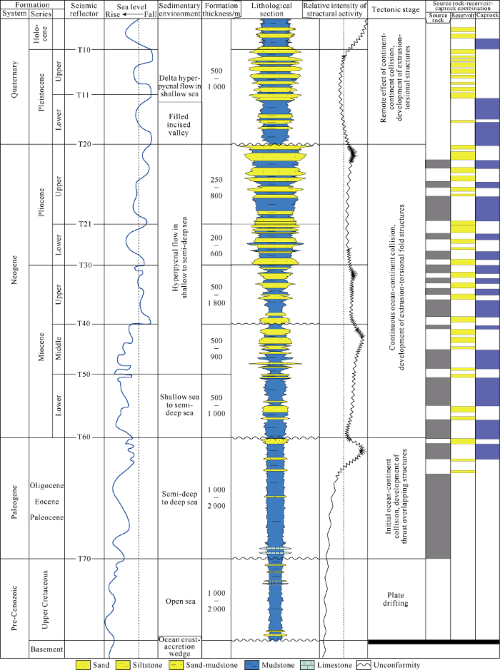
Fig. 2.
Composite stratigraphic column of Block D in the Rakhine Basin.
2. Sedimentary characteristics of hyperpycnal flow
According to Mulder et al., the measured Reynolds value of hyperpycnal flow in the Mediterranean Vaal Gorge is (6.6- 7.0) × 107, indicating that the hyperpycnal flow is in a turbulent state and belongs to the category of turbulence[29]. But hyperpycnal flow is a deepwater fluid formed by flooding, the fluid type, duration, and characteristics of the sedimentary rocks formed by the hyperpycnal flow are significantly different from the “triggered” turbidity flow.
Hyperpycnal flow is a type of quasi-stable fluid with slow changes in fluid rate. In the flood peak, the flow and rate are the highest, and then both decrease slowly and last for a long time, more than a few weeks generally. Seasonal flood may last several months and have multiple periods of flood peaks, so the sediments formed are thick and widely distributed. The conventional turbidity flow is a typical unsteady fluid. It accelerates to the maximum speed immediately after triggered, and then rapidly abates. The duration is extremely short, usually only a few minutes and the sediments formed are limited in distribution. Meanwhile, constrained by the change of flow rate and transport distance, the hyperpycnites are mainly fine sandstone and siltstone with good roundness and sorting. Pairs of normal-reverse grading beddings are typical marks of hyperpycnites, and microscopic eroded surfaces caused by flood peaks can be observed between the two kinds of beddings. The sedimentary phenomena resulted from the propulsion of current flow are commonly observed, including climbing ripple beddings, parallel beddings, and cross beddings. The typical identification mark of conventional turbidity flow is Bauma sequence, with positive grain sequence characteristics on the whole, and abrupt contact with the underlying strata, visible muddy tears. Intrusion and wrinkling phenomena such as convoluted bedding, grain sequence bedding, parallel bedding, cross-bedding and deformation structure are common[30].
2.1. Petrological characteristics
The analysis of thin section data shows that the Pliocene rock in the block is mainly sub-lithoclastic feldspar sandstone, with a quartz content of 55% to 78%, 68.4% on average, feldspar content of 15% to 21%, 19.8% on average, and lithoclastic content of 8% to 20%, 11.8% on average. The maturity of the rock composition is relatively high (Fig. 3a). Thin sections show that the debris particles in the rock are good in sorting, uniform in size, largely fine sand, generally sub- rounded to rounded, and very low in mud content (less than 5%), indicating that the debris particles have undergone long-distance transport and long-term seawater elutriation (Fig. 3b). The granularity probability curve shows a two-section pattern with good sorting of particles. The jumping part is less than 10%, and the suspension part is 10%-70%. The particle size distribution is more concentrated in the suspension part, indicating the hyperpycnal flow drops in transporting capacity with the increase of transport distance, and changes gradually from high density flow to traction flow (Fig. 3c).
Fig. 3.
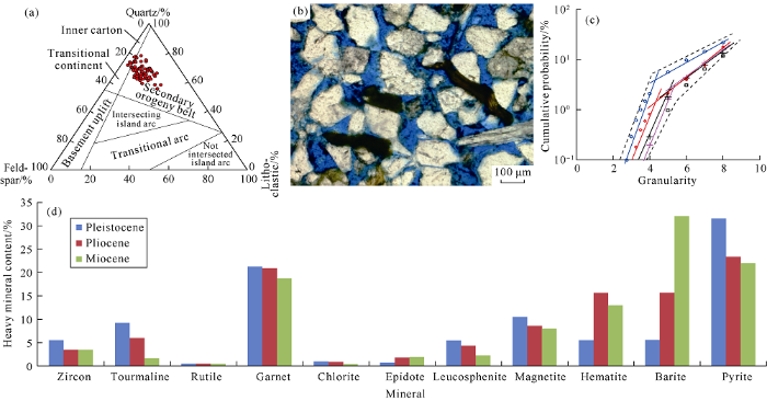
Fig. 3.
Rock composition, thin section photos, particle size probability curve, and histogram of heavy mineral content of the Pliocene in Block D of the Rakhine Basin. (a) Dickinson diagram of the Pliocene rock composition in the Rakhine Basin; (b) Well D-1, 3220.7 m, Pliocene, lithic feldspar sandstone, with good sorting and subrounded mud content of less than 3%; (c) Well A-2, 3504.0 to 3536.0 m, two-sectional granularity probability curve; (d) Histogram of heavy mineral percentage in Block D of the Rakhine Basin.
The Dickinson’s diagram method can directly reflect the tectonic environment of a provenance area[31]. The study of Dickinson’s diagram shows that the detrital material in Block D is mainly derived from the mountainous source of the secondary orogeny-Indian-Myanmar accretion wedge and partially affected by the mountainous provenance of transitional continent-Himalayas. The heavy minerals in Block D are mainly stable to super stable, reflecting that they are far away from the source. The terrigenous minerals mainly include stable minerals such as zircon, tourmaline, and garnet, as well as unstable minerals such as titanite, magnetite, and hematite, indicating that the parent rocks are dominated by metamorphic rock, medium to acid, and basic volcanic rocks[32]. The authigenic minerals are mainly pyrite and barite, and their contents are relatively high. The formation of these two types of authigenic minerals is related to hydrothermal action[33]. These evidences indicate that the detrital materials in Block D are mainly originated from the mountains of the Indian- Myanmar accretion wedge in the east, and a small part from the Himalayan range in the north (Fig. 3d).
2.2. Sedimentary facies
2.2.1. Core facies
The lithological combination of hyperpycnites is characterized by medium to thick and fine sandstone sandwiched thick dark mudstone. Its sedimentary sequence on the whole is a normal cycle, and a single sand interval has multiple inverse-normal grading cycles[34]. The mudstone is mostly dark gray and gray black, indicating they deposited in deep-water. The sandstone is fine, generally 5-10 m thick in single layer, and up to a maximum of 30 m, indicating a strong and stable hydrodynamic condition (Fig. 4). Fine core description shows that the hyperpycnites have the following typical structural characteristics: (1) pairs of inverse-normal grading cycles and microscopic eroded surfaces at the bottom of normal beddings; (2) continuous massive and parallel beddings, indicating strong hydrodynamics and flat bottom riverbeds; (3) evident climbing ripple beddings and cross beddings, indicating that suspending debris was abundant and continuously moved forward under the driving of water; (4) typical sedimentary phenomena of gravity flow such as convolution beddings and slump deformation structures, although in a relatively low proportion, indicating that relatively flat sedimentary paleotopography and rare slump deposition; (5) locally enriched terrestrial organic matters and plant debris, and little biological disturbance (Fig. 4).
Fig. 4.

2.2.2. Logging facies
Hyperpycnites are sedimentary complex with stripped characteristics formed after long-distance migration of runoff into the sea along the basin floor during the flooding period, and then unloaded in deep water. Five types of microfacies can be identified, including incised valley (supply channels), channel complex, distributary channel, natural levee, and sheet-like sand without channels, and shown as normal cycles of lithological combination. Natural gamma (or resistivity) logging curves are nearly straight curves, box-shaped, bell-shaped, tongue-shaped, or finger-shaped, representing mudstone intercalated with severely serrated sandstone. The severely serrated logging curve reflects the influence of sea water washing the deposited sandstone (Fig. 5).
Fig. 5.

2.2.3. Seismic facies
In a sedimentary environment with sufficient accommoda- tion, after rivers flow into a sea basin, the water passes through the continental shelf slope at a high speed, forming incised valleys (supply channels) of various degrees; and at the same time, with the natural acceleration of the continent slope, sediments are transported to the abyssal plain over a long distance, resulting in sediments of miscellaneous types and distinctive characteristics, which are shown as a variety of typical seismic facies on high-precision 3D seismic data.
The seismic reflection of the mud filling in incised valley is blank with low frequency and poor continuity, and there is a clear incision boundary with the surrounding strata. The reflection of sand filling in the incised valley, however, is of low frequency, poor continuity and strong amplitude. The channel complex generally exhibits low frequency, poor continuity, and strong amplitude in seismic reflection, shows as typical multi-phase highly-curved channel on stratigraphic slice, with sedimentary characteristics similar to continental meandering rivers. The characteristics of multi-stage superimposed channels can be identified in the crosscutting seismic section, and this type of the multi-stage superimposed highly-curved channel is the key to the development of high-quality reservoir in deep water. The seismic reflection of distributary channels is mainly characterized by low and medium frequency, medium continuity, and strong amplitude, and has the characteristics of incised channels, but smaller amplitude than composite channels. The overbank natural levee occurring largely on both sides of channels feature medium frequency, medium-poor continuity, and medium-strong amplitude on seismic reflection, and takes on a seagull wedge shape on the outside. The sheet-like sand without channel is mainly characterized by high frequency, medium-poor continuity, and weak amplitude on seismic reflection, and generally comes in sheet, hummock, or stack shapes (Fig. 5).
2.3. Sedimentary system
2.3.1. Sedimentary subfacies
The sedimentary system of hyperpycnal flow can be divided into four types of subfacies, incised valley, channel, overbank, and lobe. The continental shelf and continental slope mainly have incised valleys of multiple phases (supply channel). The abyssal plain is the main body of hyperpycnal flow deposits, where multi-phases and multi-branches highly curved channels and front sheet-like sand without channel occur.
2.3.1.1. Incised valleys
Incised valleys are “roots” in the sedimentary framework of hyperpycnal flow and are supply channels for the flooding river to transport detrital materials to deepwater basins. They are shown as developed incised valleys filled with muddy and sandy materials. The water flow of flooding rivers shows high density and high speed, and can form restrictive incised valleys which are very deep on the continental shelf and slope. There are two types of incised valleys, mud-filled and sand-filled in the study area. The mud-filled type is that after the rapid passing of water through the continental slope, the turbulence causes lighter mud to float up. After the water is stationary, mud-filled valleys are formed, which are very thick and locally distributed. They are generally developed in the upper part of the continental slope. The GR logging curve shows high values and a flat linear pattern. As the continental slope decreases, the hydrodynamic strength of flood continues to decline and a small amount of sandy deposits gradually appear in the valleys, forming sand-filled incised valleys. The GR logging curve is tongue-shaped, with straight and medium amplitude and protrusion of mudstone baseline. They are generally developed in the lower part of the continental slope.
2.3.1.2. Channels
Channels are the “backbone” of the sedimentary framework of hyperpycnal flow through which runoff enters the gentle abyssal plain after the acceleration down the continental slope. The discovered channels in the study area can be subdivided into channel complexes and distributary channels.
The channel complex is the major branch of the channel subfacies and the main component of the stripped sediment. Vertically, it shows multi-phase superimposition, with a cumulative thickness greater than 8 m generally. Mudstone boulder is rarely observed inside the superimposed sandstone. The bottom sandstone boundary abruptly contacts with the underlying mudstone. Massive beddings and parallel beddings are commonly observed and convolution beddings are locallly observed. The lithology is dominated by medium-fine sandstone, with good sortability and roundness and low mud content. The logging facies is of high amplitude and serrated box shape.
The distributary channel is the part where hyperpycnal flow channel decreases in hydrodynamics and begins to diverge into multiple small distributary channels, and the front extension of the channel complex. Different phases of them also stack over each in the vertical direction. The sandbody of this subfacies is generally 5-8 m thick, and is mainly fine sandstone, with good roundness and sorting, massive bedding and graded bedding. This kind of sandstone features serrated bell shape and box shape with medium-high amplitude on logging facies.
2.3.1.3. Overbank
The overbank subfacies is distributed on both sides of channel complexes, and overbank natural levees are developed. The natural levee microfacies is mainly composed of fine sandstone and siltstone, with finer grain size and a thickness of 3-5 m. They are wrapped in channel complex or distributary channel sandstones, and have climbing ripple bedding, ripple cross bedding, and vein bedding from core observation. They feature gradually serrated tongue shape with medium -high amplitude on log facies. Among them, climbing ripple bedding is very rare in deep-water sediments, and is a typical sign that distinguishes hyperpycnal flow deposits from other deep-water gravity flow deposits.
2.3.1.4. Lobe
The lobe subfacies is the “tip” in the sedimentary framework of hyperpycnal flow, and mainly includes sheet-like sand microfacies without channel in the channel front. The sandbody of sheet-like sand microfacies without channel is thin and widely distributed and wrapped in thick mudstone. The sandbodies are made up of mainly argillaceous siltstone and silty mudstone, and generally less than 1 m thick. On logging curve, they feature low-amplitude tongue shape, and have lenticular beddings and horizontal beddings on core.
2.3.2. Distribution of the sedimentary system
Guided by the “source-sink” system theory, analysis started from the source area, then the sediment transport pattern, and finally the sediment accumulation pattern[35,36,37]. The study shows that the Pliocene in Block D is mainly controlled by the mountainous source from the Indian-Burmese accretion wedge with the development of multiple hyperpycnal flow sediments characterized by the distribution law of “multi- stage development, long-distance transport, and stripped sand enrichment”.
Petrological analysis shows that the source of the block is mainly from the mountain in the Indian-Burmese accretion wedge in the east, which is directly controlled by the flooding river, and a large amount of detrital material was injected into the block. The northern Himalayas Mountain only provided a small amount of debris. In the northeastern D6, a number of large southeastward incised valleys can be identified, which are reliable channels for the erosion of the continental shelf and continental slope by the flooding river and the transportation of clastic materials to the basin. The study of the RMS- amplitude seismic attributes on the 3D seismic section and the characteristics of the seismic facies in the 2D survey block of the Pleistocene in the study area (Fig. 6) shows that there are eight stripped hyperpycnal flow sediments in the Pliocene in the block D6. Among them, the hyperpycnal flow sediments 1-6 are large, extending over hundreds of kilometers, and the sandbodies are widely distributed. In the block, hyperpycnal flow sediments 7-8 only show the development of water channels and sheet-like sand without channels (Fig. 7). Multi- phase and multi-branch hyperpycnal flow channels would inevitably form intersections during the propulsion. Thick hyperpycnal flow sandstone layers were deposited in the intersection area. No. 2 and No. 3 hyperpycnal flow channels were intersected during the progradation, making the development of thick hyperpycnal flow channel sandstone between Wells D-1 and E-2 in the block. As the hydrodynamic condition of the hyperpycnal flow continued to weaken during the propulsion process, the front ends of channels were bifurcated to form multiple distributary channels, with the deposition of fine sandstone 5-8 m thick. With the further decrease of fluid concentration and flow velocity, a widely distributed lobe was formed at the distributary channel front, with the deposition of thin-layered fine-grained sandstone without channels.
Fig. 6.

Fig. 6.
Superimposed map of RMS amplitude and coherence attribute of the Pliocene in the 3D seismic area of Block D in the Rakhine Basin (the work area is shown in
Fig. 7.
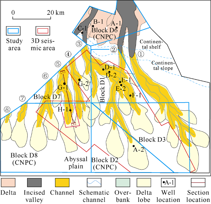
Fig. 7.
Sedimentary systems of the Pliocene in Block D and periphery blocks of the Rakhine Basin.
2.3.3. The sedimentary model of hyperpycnal flow
According to the distribution pattern of the sedimentary systems of hyperpycnal flow in the Pleistocene of the block, a sedimentary model of hyperpycnal flow “controlled by flooding sources, multi-stage and multi-level development, stripped and enriched sandstone” was established (Fig. 8). The block is mainly controlled by the sources from the flooding rivers originated from the Indian-Myanmar accretion wedge in the east. Under the control of sudden or seasonal flood, a large amount of detrital material was injected into the basin, forming large-scale hyperpycnal flow deposits. The river water in a single flood was quickly injected into the ocean basin and passed through the continental shelf and continental slope rapidly, resulting in multiple incised valleys, then into the abyssal plain, and finally forming hyperpycnal flow channels with strong hydrodynamics under the acceleration of gravity. As a result, large amounts of detrital materials were transported to the abyssal plain. In the area of the abyssal plain adjacent to the continental slope, the hydrodynamics of hyperpycnal flow channel was so strong that it incised the early sedimentary strata, forming restrictive channels, a small amount of overbank levee deposits on both sides of the channels, and a small amount of retained sandstone inside the channels. As the channels advanced, the hydrodynamics weakened, and the restricted channels gradually became unrestricted and branched, then the branch channels could intersect, forming multiple levels of secondary channels. The secondary channels can also divert and intersect to third-level channels, and so on. Eventually, distributary channels were formed as the decrease of fluid concentration and rate. Fan-shaped lobes would be formed at the front of distributary channels. Horizontally, the multi-source and multi-branch hyperpycnal flow channels and lobes were gradually derived, forming constructive deep-water deposits of hyperpycnal flow over a long distance; vertically, the deposits of different periods and generations superimpose with each other, forming continuously superimposed fans. The multi-source, multi- phase, and multi-branch hyperpycnal flow channels and lobes are spatially superimposed, forming hyperpycnal flow sandstone with wide distribution, large thickness, and excellent physical properties. They are solid foundation for the enrichment of oil and gas in deep water.
Fig. 8.
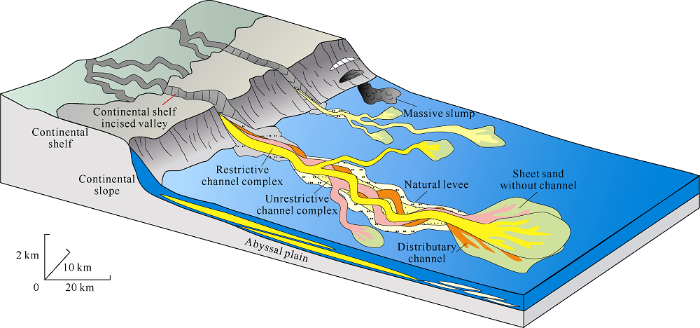
Fig. 8.
Sedimentary model of hyperpycnal flow deposits.
3. Favorable reservoir sandstone
3.1. Physical properties
The analysis of physical properties shows that the hyperpycnites are relatively thick and show a good reservoir capacity, with a porosity of up to 33.4 %, 19.7 % on average; and a permeability of up to 653×10-3 μm2, 84.6×10⁻³ μm2 on geometric average. The sandstones of different microfacies differ significantly in physical properties. The channel complex and distributary channel sands are thick and have the best reservoir capacity, with an average porosity of about 25 % and a permeability range of (73.3-653.0)×10-3 μm2. The natural level sands are medium in thickness and have better reservoir capacity, with a porosity greater than 15 % and a permeability range of (8.0-79.4)×10-3 μm2. The sheet-like sands are thin and poor in storage capacity, with a porosity of less than 20% and permeability of less than 26×10-3 μm2 in general (Table 1).
Table 1 Physical properties of reservoir of different sedimentary microfacies in the Pliocene of Block D, the Rakhine Basin.
| Microfacies | Sandstone thickness/m | Sandstone ratio/% | Porosity/% | Permeability/10-3 μm2 | ||
|---|---|---|---|---|---|---|
| Range | Mean | Range | Mean | |||
| Channel complex | >8 | 45-60 | 19.2-33.4 | 27.7 | 161.00-653.00 | 353.0 |
| Distributary channel | 5-8 | 25-45 | 18.1-30.8 | 25.4 | 73.30-363.00 | 230.8 |
| Natural levee | 3-5 | 15-35 | 15.4-24.8 | 19.8 | 8.00-79.40 | 46.3 |
| Sheet sand without channel | <3 | <15 | 13.7-18.5 | 16.1 | 4.83-26.00 | 14.7 |
In environments with similar conditions such as tectonic and diagenetic conditions, sedimentary microfacies is the main factor controlling the reservoir capacity. The channel complex and distributary channel sands are thick, well sorted, and low in shale content, and dominated by medium-fine sandstone with good reservoir capacity. The natural levee microfacies sand is medium in thickness and composed of siltstone and fine sandstone, and medium in quality. The sheet sand without channel is thin, fine, and mainly siltstone with poorer reservoir capacity.
3.2. Prediction of favorable sandstone
The channel complexes and distributary channels are the facies for the development of high-quality reservoir sandstone. However, the style of sedimentary architecture of submarine channels is complex and changeable, how to identify such sedimentary sandbodies is the key to deepwater oil and gas exploration. Under the guidance of the sedimentary model of hyperpycnal flow, the study aimed at the No. 4 hyperpycnal flow sedimentary body in the key target area, by using seismic reflections, spectral waveforms, slice and attribute fusion to carry out fine prediction on the microfacies of channel complexes and distributary channels.
The channel complexes are characterized by large thickness and low mud content, and the seismic reflections are evident lenticular reflections with medium-low frequency, strong amplitude, and medium continuity. The front section of the channel complexes shows the development of distributary channels, and the thickness is medium, and smaller than that of the non-restrictive channels. The seismic reflection is characterized by medium frequency, medium-strong amplitude, and continuity. The sheet-like sand without channels is located at the front end of the distributary channel, and the thickness is small. The seismic reflection is dominated by a continuous transition from high-frequency and weak amplitude to a mat reflection structure. On the lateral of the channel, the natural levee microfacies is developed, which is moderately thick and relatively fine, and generally it is siltstone with sand bar formed with evident migration of the channels. The overbank natural levee is generally dominated by an oblique lenticular reflection structure with medium frequency, strong amplitude, and good continuity.
Besides the analysis of spectral waveforms and seismic reflection structures, seismic slice and attribute fusion was used to analyze the target layers in the study area. On the seismic attribute profile of the No. 4 sedimentary body of hyperpycnal flow (Fig. 9a), there is a continuous stripped zone with strong amplitude (Fig. 9a). On the slice, there are evident superimposed characteristics of curved channels (Fig. 9b), which turn to be channel complexes from typical profiles (Fig. 9c). The flanks show the development of seismic attributes with a meniscus-shaped medium-weak amplitude zone (Fig. 9a), and the seismic profile is evidently seagull wing-shaped, which is the characteristic of overbank natural levee microfacies. The front of the body has a zone of intersected branch channels with medium-strong amplitude (Fig. 9a), representing distributary channel microfacies. There are fan-shaped weak-amplitude zones (black-gray) between or on the flanks of distributary channels, which show mat-like and mound-like reflection characteristics on seismic section, and are sheet sands without channel (Fig. 9d).
Fig. 9.

Fig. 9.
Fine characterization of microfacies of No.5 hyperpycnal flow depositional body (the profile location is shown in
Based on comprehensive analysis of seismic reflections, spectral waveforms, and slice and attribute fusion, the distri-bution of microfacies in No. 5 hyperpycnal flow sedimentary body were delineated finally (Fig. 9e), which predicted the planar distribution pattern of the channel complexes and the distributary channels accurately, thereby providing a basis for the selecting of exploration well locations.
4. Hydrocarbon accumulation potential
Compared with sandy detrital flow and conventional turbidity flow, hyperpycnal flow is controlled by seasonal or sudden floods, doesn’t need a large stacking of detrital material and certain triggering mechanisms[38,39,40]. Therefore, it frequently happens and can transport clastic materials to deepwater basins over a long distance and form large-scale high- quality reservoir sandbodies sandwiched in source rocks. These sandbodies have good oil and gas geological conditions and the potential to form hydrocarbon accumulations.
4.1. Good configuration of source rock, reservoir and caprock
Hyperpycnite is a deepwater sedimentary product formed by seasonal or sudden floods. Its comprehensive sedimentary sequence is abyssal mudstone - hyperpycnite - abyssal mudstone, which constitute good source-reservoir-caprock combination. In the combination, the thick sandstone in hyperpycnal flow depositing after a long-distance transport has high maturity, moderate sand to mud ratio (30% to 50%), and good physical properties, and they can be high-quality reservoirs. Under the large-scale injection of floods, the hyperpycnal flow not only carries substantial detrital materials, but also terrestrial organic matter to the catchment basin, forming organic-rich strata and improving the quality of source rocks. As a result, the large-scale high-quality reservoir sandbodies are wrapped in high-quality source rocks, forming a good configuration of source rock, reservoir, and caprock, which lays solid foundation for enrichment and accumulation of oil and gas.
4.2. Lithologic traps developed
The study on the regional tectonics shows that the late tectonic activity in Block D was intense, and NS-trending fold belts were developed, coupled with the unique sedimentary characteristics of the hyperpycnal flow, various types of oil and gas reservoirs can be formed.
The discovered gas reservoirs such as Shwe-Mya, Thalin indicate that structure-lithologic traps are primary types of oil and gas reservoirs in the Rakhine Basin. The Shwe-mya gas reservoir is an anticlinal structure located in the south-to-north fold belt, and the reservoir is the channel complex sandstone of the upper Cenozoic. The structure controls the macroscopic oil-gas accumulation background, and the sand body controls the oil-gas accumulation scale, so it is a typical structural-lithologic composite oil-gas reservoir. The unique sedimentary process of hyperpycnal flow is also easy to form many types of lithological traps. Both sides of the complex microfacies are mainly overbank natural levee deposits and they transit to abyssal mud outward. Once the channel complexes are incised by late mud-filled channels, it is easy to form lithological traps with good sealing conditions, and Thalin gas reservoir is the gas reservoir formed by such lithologic traps. The retained sandstones in the mud-filled channels of hyperpycnal flow are another effective lithologic trap[41].
In addition, typical gas chimney phenomenon has been identified in Block D. Biogenic gas or natural gas generated in deep formations can transport upward along the gas chimney belt, and accumulate in high-quality reservoirs on the two wings or top of the gas chimney to form oil and gas reservoirs related to gas chimney. Due to gas charge, the seismic wave propagation speed in the gas chimney zone drops, and the seismic event would show pulling-down feature, which gives the strata on both wings and top of the chimney bright spot and flat spot[42]. So far, multiple lithological traps and trap types related to gas chimneys have been discovered in Block D, showing great potential of oil and gas exploration[42] (Fig. 10).
Fig. 10.
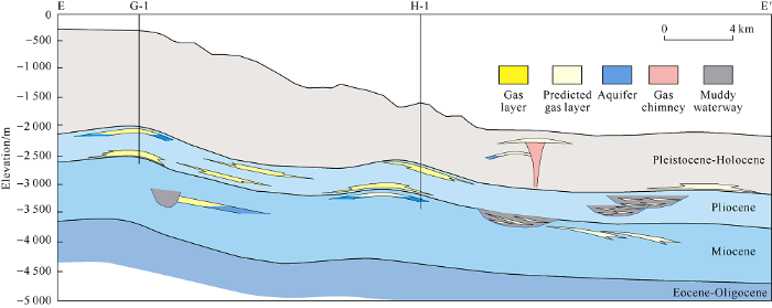
Fig. 10.
Hydrocarbon accumulation model in Block D (the profile location is shown in
4.3. Great resource potential
According to the results of fine structural interpretation and reservoir sandbody prediction, an exploration Well H-1 was deployed in the No.5 hyperpycnal flow sedimentary sandbody. A gas column 60 m high with a pure gas layer of 10 m in the Pleistocene, and a gas column of 45 m high with pure gas layer of 16 m in Pliocene were detected in this well. The well was tested a high-production gas flow of 150 × 104 m3 a day, and has an estimated resources scale of 500 × 108 m3, marking the first major exploration breakthrough since CNPC entered the Rakhine Sea, which is also the third largest oil and gas discovery in the Rakhine Sea. This discovery not only shows good exploration prospects of deepwater hyperpycnal flow sandbodies, but also drives the oil and gas exploration process in Block D and even in the Rakhine Basin. It is estimated that the reserve scale of gas reservoirs formed by hyperpycnal flow sandbodies in the entire Rakhine Basin is about (3700-13300)×108 m3. According to observation of 147 rivers worldwide by Mulder etc[1], 71% of the rivers can form hyperpycnal flow. This discovery of oil and gas reservoir in hyperpycnites is of great theoretical and practical significance for the origin study, reservoir prediction and oil and gas exploration in deep-water sandbodies around the world, and will boost the oil and gas exploration in deep waters worldwide.
5. Conclusions
In Pliocene, Block D of Rakhine basin was high in the northeast and low in the southwest, and the source materials were from the eastern Indo Myanmar mountains and a small part from the northern Himalayas. Driven by seasonal or sudden floods, multi-branch, multi-generation and multi-stage deep-water hyperpycnal flow deposits were formed, which are characterized by “multi-phase development, long-distance transportation, and strip sand enrichment” macroscopically. The high quality deep-water sands appear in strips and stack over each other vertically. The feeding mechanism and microfacies types of hyperpycnal flow are the main factors controlling the development of high quality reservoir. The channel complex microfacies with thick sandbodies, good sorting and roundness, and low mud content are the most favorable facies for exploration. Under the guidance of the hyperpycnal flow sedimentary model, the distribution of channel complex microfacies was depicted by using the seismic reflection structure analysis, spectrum waveform feature analysis, slice and attribute fusion in detail. Combined with macroscopic structure analysis, the favorable exploration areas and well location targets were sorted out, effectively guiding the exploration deployment in the block. Eventually, a large-scale high yield gas reservoir was discovered by drilling. The discovery of high quality hyperpycnal flow reservoir sandstone in Block D of Rakhine basin will guide reservoir prediction and oil and gas exploration in deep waters in the future.
Reference
Turbidity currents generated at river mouths during exceptional discharges to the world oceans
DOI:10.1086/629747 URL [Cited within: 3]
Marine hyperpycnal flows: Initiation, behavior and related deposits, a review
DOI:10.1016/j.marpetgeo.2003.01.003 URL [Cited within: 2]
Rational theory of delta formation
Climatic and morphologic relationships of rivers: Implications of sea level fluctuations on river loads
DOI:10.1086/629849 URL [Cited within: 1]
Current hot topics and evinces of sedimentology: A summary from 19th International Sedimentological Congress
DOI:10.7605/gdlxb.2014.06.065
URL
[Cited within: 1]

The current research hotspots and advances of international sedimentology has been analyzed based on the data of 19th International Sedimentological Congress,which indicates that global climatic sedimentary record,deepwater sedimentology and event deposition,and carbonate and microbial sedimentology are becoming the three current hot issues in sedimentology besides the continual hot topic: resources sedimentology. Main progresses in global climate sedimentary record came from sedimentary recorders exploration for detailed climate change,climatic environmental and ecological effects and the climate macro-change rules of deep time in a special geological time or a special geological realm. Main advances in deepwater sedimentology and event deposition were embodied in sedimentary process study,such as hydraulic jump and field monitoring of deepwater sedimentary process,and event deposition triggered by earthquake,tsunami,flood,volcanic,etc.,and the turbidite prediction and hydrocarbon exploration. Advances in carbonate and microbial sedimentology were expressed in cold water carbonate deposition and microbial controls on carbonate deposition. Comparison shows that sedimentary study in China focuses on continental facies such as fluvial and lacustrine but seldom on eolian,glacier and coastal environment;focuses on applied resource sedimentology and so forth,but rarely on basic scientific problems such as sedimentary dynamic process study in terms of the study objectives;focuses more on deepwater sedimentation and unconventional resource geology in three hot issues,but confined them to the sedimentary phenomenon description,hydrocarbon exploration and development. Finally,the authors suggest that three breakthrough directions possibly come from more attentions paid to sedimentary dynamic process and source-channel-sink system analysis,and timely introduction of the deepwater and cold carbonate sedimentation and biological geology theory,and global climate change studies with full-use of a large number of scientific drillings and wells information from oilfield drilling.
Erosional sculpting of the Caprera confined deep-sea fan as a result of distal basin-spilling processes(eastern Sardinian margin, Tyrrhenian Sea)
DOI:10.1016/j.margeo.2009.10.012 URL [Cited within: 1]
New perspectives on deep-water sandstones: Implications
Dimensions and architecture of late Pleistocene submarine lobes off the northern margin of East Corsica
DOI:10.1111/j.1365-3091.2007.00926.x URL [Cited within: 1]
Subaqueous sediment density flows: Depositional processes and deposit types
DOI:10.1111/sed.2012.59.issue-7 URL [Cited within: 1]
Sedimentation in large rift lakes: Example from the Middle Pleistocene—Modern deposits of the Tanganyika Trough, East African Rift system
Hyperpycnal plume formation from riverine outflows with small sediment concentrations
DOI:10.1046/j.1365-3091.2001.00384.x URL [Cited within: 1]
Hyperpycnal-fed turbidities lobe architecture and recent sedimentary processes: A case study from the Al Batha turbidite system, Oman margin
DOI:10.1016/j.sedgeo.2009.03.009 URL [Cited within: 1]
Flood deposits in continental and marine environments: Character and ignificance: ZAVALA C, SLATT R M. Sediment transfer from shelf to deep water-Revisiting the delivery system
Hyperpycnal plume formation from riverine outflows with small sediment concentrations
DOI:10.1046/j.1365-3091.2001.00384.x URL [Cited within: 1]
Discovery of a large-scale lacustrine subaqueous channel in Nenjiang Formation of Songliao Basin and its implication on petroleum geology
Depositional evolution and accumulation response of Yaojia-Nenjiang Formation in Songliao Basin
The importance of plant re-mains as diagnostic criteria for the recognition of ancient hyperpycnites
.
On the triggers, resulting flow types and frequencies of subaqueous sediment density flows in different settings
Inversely graded turbidite sequences in the deep Mediterranean: A record of deposits from flood-generated turbidity currents?
DOI:10.1007/s003670100071 URL [Cited within: 1]
Reply to discussion by Shanmugam on Mulder et al: Inversely graded turbidite sequences in the deep Mediterranean: A record of deposits from flood-generated turbidity currents?
DOI:10.1007/s00367-002-0096-8 URL [Cited within: 1]
Introduction to the petroleum geology of deep-water settings
Pliocene basin-floor fan sedimentation in the Bay of Bengal(offshore northwest Myanmar)
DOI:10.1016/j.marpetgeo.2013.09.007
URL
[Cited within: 1]
This study addresses reservoir development and hydrocarbon occurrence of the late Pliocene basin-floor fan deposits in the northeastern Bay of Bengal. The G-series turbiditic sandstones host dry gases, biogenic in origin, of three gas fields that are juxtaposed on the western flank of the NW-SE anticline. The gas reservoirs are stacked in back-stepping fashion being sourced from northwest as part of the Bengal fan.
The Shwe field (Shwe fan) has an elongate fan-shaped morphology (12 km long and 4 km wide) and occurs about 30 km off the base of slope. The Shwe field reservoirs consist of two contrasting types of turbidite deposits, lower G5.2 and upper G3.2 reservoirs. The G5.2 is characterized by stacked lobe elements in which amalgamated and layered sheet sandstones provide an excellent vertical connectivity and high net-to-gross ratio (avg. 86%). On the contrary, the G3.2 represents overbank deposits, which is characterized by thin-bedded sandstones with low net-to-gross ratio (avg. 33%) as well as low-resistivity pays.
Aside from the primary depositional framework, post-depositional modifications appear to have greatly affected Shwe fan, adding complexity in establishing a geological model. A line of evidence suggests that G5.2 lobe sands were injected into overlying G3.2, mostly in the form of sills. The injected sand beds measured from G3.2 cores account for 10 m, more than half of the total net sand. The sand injection is thought to be triggered by slumping that overpressured G5.2 lobes. Post-G3.2 erosional channel complexes incised into G5.2 and G3.2, ultimately diminishing gas pool extent as well as dividing Shwe fan into multiple compartments. (C) 2013 Elsevier Ltd.
Pliocene basin-floor fan sedimentation in the Bay of Bengal(offshore northwest Myanmar)
DOI:10.1016/j.marpetgeo.2013.09.007
URL
[Cited within: 3]
This study addresses reservoir development and hydrocarbon occurrence of the late Pliocene basin-floor fan deposits in the northeastern Bay of Bengal. The G-series turbiditic sandstones host dry gases, biogenic in origin, of three gas fields that are juxtaposed on the western flank of the NW-SE anticline. The gas reservoirs are stacked in back-stepping fashion being sourced from northwest as part of the Bengal fan.
The Shwe field (Shwe fan) has an elongate fan-shaped morphology (12 km long and 4 km wide) and occurs about 30 km off the base of slope. The Shwe field reservoirs consist of two contrasting types of turbidite deposits, lower G5.2 and upper G3.2 reservoirs. The G5.2 is characterized by stacked lobe elements in which amalgamated and layered sheet sandstones provide an excellent vertical connectivity and high net-to-gross ratio (avg. 86%). On the contrary, the G3.2 represents overbank deposits, which is characterized by thin-bedded sandstones with low net-to-gross ratio (avg. 33%) as well as low-resistivity pays.
Aside from the primary depositional framework, post-depositional modifications appear to have greatly affected Shwe fan, adding complexity in establishing a geological model. A line of evidence suggests that G5.2 lobe sands were injected into overlying G3.2, mostly in the form of sills. The injected sand beds measured from G3.2 cores account for 10 m, more than half of the total net sand. The sand injection is thought to be triggered by slumping that overpressured G5.2 lobes. Post-G3.2 erosional channel complexes incised into G5.2 and G3.2, ultimately diminishing gas pool extent as well as dividing Shwe fan into multiple compartments. (C) 2013 Elsevier Ltd.
Geological modeling with seismic inversion for deepwater turbidite fields offshore northwestern Myanmar
The identification and implication of injectites in the Shwe Gas Field, offshore Northwestern Myanmar
Biogenic gas potential of myanmar
A study of provenance and sedimentary facies of accretionary wedge basin: Taking a block in Myanmar as an example
Tectonic features and dynamic evolution of bay of Bengal Basin: New insights into satel-lite-gravity and seismic data
DOI:10.3799/dqkx.2014.123 URL [Cited within: 1]
Inversely graded turbidite sequences in the deep Mediterranean: A record of deposits from flood generated turbidity currents?
DOI:10.1007/s003670100071 URL [Cited within: 1]
Sediment dynamics process and sedimentary characteristics of hyperpycnal flows
New insights into multiple provenances evolution of the Jurassic from heavy minerals characteristics in southern Junggar Basin, NW China
Progress in “Source-to-Sink” system research
Sedimentary characteristics and distribution patterns of hyperpycnal flow in rifted lacustrine basins: A case study on lower Esl of Banqiao slope in Qikou Sag
Advances of the Source-to-Sink units and coupling model research in continental basin
New advances of the “Source-to-Sink” system research in sedimentary basin
Research on sedimentary process and characteristics of hyperpycnal flows
Research progresses on hyperpycnal flow deposits
DOI:10.14027/j.cnki.cjxb.2016.03.003
URL
[Cited within: 1]
Based on literature investigations, research status on hyperpycnal flow was summarized mainly including flowing process, fluid properties, controlling factors, sedimentary characteristics. Sedimentary method among hyperpycnal flow and other gravity flows was discussed and depositional model on “channel-ligule-lobe” was constructed, accompanying with the research example from Mesozoic lacustrine hyperpycnites. Hyperpycnal flow is a kind of sustained turbidity currents generating from flood-river estuary, flowing along the bottom of water for its higher density than catchment basins water. It has frequent occurrences and stable sediments supplies, which triggered by river floods. The phenomenon on the plunging of fluid is the symbolism of formation on hyperpycnal flow. It can make a long-distance transportation along the bottom of the water body, as long as the adequate slope existes at the bottom of basins. Hyperpycnal flow belongs to Newtonian rheology, presenting turbulent state, being supported by fluid turbulence. It has no need of the early accumulation and transportation again on sediments, and event-triggered mechanisms like earthquake, volcano eruption, storm and tsunami. Hyperpycnal flow is controlled by factors of topography, climate and density differences. It takes place in both marine facies and terrestrial lacustrine basin. The current researchers, however, have not paid enough attention to the hyperpycnal flow deposits in terrestrial lacustrine basin,although advantages of lower water density, closer to source areas, enough terrain altitude difference, well developed small and medium sized river and active tectonic movements, always exist in lakes. Hyperpycnal flow appears a diluting tendency from vicinity to distance and corresponds to specific sedimentary structures and sequences. With the hydrodynamic conditions decreased gradually, sediments of hyperpycnal flow present a tendency that grain size much smaller, sand thickness much thinner to the center of basin. Most of them are medium sized sandstone, fine sandstone and siltstone. The distribution is much steady horizontally. And it appears to the shape of fan which consists of “channel-ligule-lobe” accompanying with natural barrier on plane. Channel is linked directly to underwater distributary channel, the place where erosion and filling mainly happened. Channel-ligule in the middle of sedimentary sandbody develops mostly. And lobe at the distal ends can extend a long distance. Hyperpycnites or hyperpycnal flow sediments can be distinguished from turbidites by: well developed micro-erosion surfaces, the combinations of upward-coarsening intervals and upward-fining intervals formed in waxing and waning flows, and rich in terrestrial organic matters. The triggered gravity flows deposits can be the result of the transportation again about the sediments of hyperpycnal flow. The mix of them is good for keeping high density and stability. Thus, hyperpycnal flow can accompany with other gravity flows to form thick sandstones with much more complicated factors. Research on hyperpycnal flow deposits has important scientific values and practical significances to make further researches. It will not only be propitious to fulfill sedimentary theory of deep-water gravity flows and to analyze sedimentary environment, but also in favor of guiding exploration on deep-water unconventional petroleum.
Review of hyperpycnal flow
Discovery of hyperpycnal flow deposits in the Late Triassic lacustrine Ordos Basin
DOI:10.14027/j.cnki.cjxb.2015.01.002
URL
[Cited within: 1]
As a major focus of both academic and industrial circles, deep-water sandy sedimentation is not only a record of gravity flows transporting a great deal of continental sediments into basin, but also important reservoir of oil and gas with great economic value. Subaqueous sediment density flows are one of the most important processes for moving sediments from provenance to depositional basins, but people still know little about these subaqueous gravity flows such as slump, sandy debris flow, muddy debris flow, granular flow, fluidized flow, turbidite current, and so on. What is more, they are extremely difficult to monitor directly. A new kind of gravity flow sandstone deposits diferent to sandy debris flow and slumping turbidity current was discovered in the sixth and seventh member of Yanchang Formation (for short, YC6 and YC7 members) in the southern part of the deep lacustrine Ordos Basin. Characteristics of the gravity flow deposits dominated by: ① a series of upward coarsening interval (inverse grading) and upward fining interval (normal grading) always exist in pairs; ② changes of relative high clay content (high-low-high) consistent with that of granularity (fine-coarse-fine) in each size-graded couplet; ③ inner micro-erosion surface sometimes separated a couplet of an upper, upward fining interval and a lower, upward-coarsening interval; ④ sandstone interbedded with dark mudstone and grey siltstone; and ⑤ granularity changes in silty mudstone is similar to that of sandstone. It was considered as flood-generated hyperpycnal flow deposit in the late Triassic deep lacustrine Ordos Basin, based on drill core observation and slice identification. A hyperpycnal flow is a kind of sustainable turbidity current occurring at a flooding river mouth when the concentration of suspended sediment is so large that the density of the river water is greater than that of lake (sea) water. It is turbid river plume that can plunge to form turbidity current where it enters a water body with lesser density and flow at basin floor. Associated with high-suspended concentration, hyperpycnal flow can transport considerable volume of sediment to lacustrine basins. Mapping of individual flow deposits (beds) emphasizes how a single event can contain several flow types, with transformations between flow types. Flow transformation may be from dilute to dense flow, as well as from dense to dilute flow. Turbid river flow must move through transfer belt of a backwater zone, depth-limited plume, and plunging zone before becoming a turbidity current. The transfer belt can extend tens of kilometers offshore and significantly affect the transfer of momentum from river to turbidity current. Sedimentary architecture of deep lacustrine gravity flows in the southern part of the late Triassic Ordos bain consist of sandy debris flow deposits, turbidites and hyperpycnites, interbedded with fine-grained deposits (thin turbidites, hyperpycnites, and deep lacustrine mudstones). Sand and mud rich turbidite systems fed by mountainous “dirty” rivers and slumps at deep angle deltas front. Storm-influenced, hyperpycnal flows generated subaqueous channelized forms at the mouth of the river deltas, which later filled with sand. The typical deposit of hyperpycnal flow in the YC6 and YC7 members in the southern part of the deep lacustrine Ordos Basin is a compound of a basal coarsening-up unit, deposited during the waxing period of discharge, and a top fining-up unit formed during the waning period of discharge. Hyperpycnites differ from other turbidites because of their well-developed inversely graded intervals and intrasequence erosional contacts. Deposits of hyperpycnal flow, hyperpycnite is different to others turbidite as for well developed upward-coarsening interval and inner micro-erosion surface in size-graded couplets. The lower, upward-coarsening interval represents deposition of waxing hyperpycnal flow. The upper, upward-fining interval was generated from waning hyperpycnal flow. The two parts of the size-graded couplet of upward-coarsening interval and upward-fining interval in pairs represent a cycle of event sedimentary of flood-generated hyperpycnal flow. The micro-erosion surface that sometimes divides the two parts of the size-graded couplet resulted from waxing flows of sufficiently high velocity to erode the sediment previously deposited by the same flow. Some bed forms and sediment grading patterns in hyperpycnal- flow deposits can record multiple flow accelerations and decelerations even during a simple single-peaked flood. Because hyperpycnal flow provides one of the most direct connections between terrestrial sediment sources and lacustrine depositional basin, its deposits might preserve an important record across a variety of climatic and tectonic settings. Depositional processes in the late Triassic deep lacustrine in the studied area were dominated by sediment gravity flows originating from gravity induced slumps and mountainous “dirty” river discharged hyperpycnal flow. Gravity flows deposits in the YC6 and YC7 members in the southern part of the deep lacustrine Ordos Basin appear to be primarily controlled by the strong climatic and tectonic forcing parameters. The basin also must be deep enough, in some cases greater than tens of meters, in order for the plume to collapse and form a turbidity current. All in all, controlling factors of hyperpycnal flow include seasonal flood river, deep angle depositional slope, enough water depth and large density difference between basinal water mass and discharged flood river. The discovery of hyperpycnite in Yanchang Formation in the Ordos Basin can not only provide an example to probe hyperpycnal flow deposits in continental lacustrine environment, but also has theoretical and realistic significances to study on genesis of deep water sandbodies, to reservoir forecasting and oil-gas exploration.
Seismic response and geological characteristics of mass-transport deposits in the Rakhine Basin, offshore Myanmar
Zonation and hydrocarbon accumulation rules of gas chimney in the In-do-Burmese Wedge
