


Introduction
There are huge hydrocarbon resources in the thick, pervasive Lower Paleozoic dolostone of Tarim Basin[1,2], but its degree of exploration is low, especially in the sub-salt Cambrian System. There had been no breakthroughs in hydrocarbon exploration in the sub-salt Cambrian since Well He4 revealed the dolostone/gyprock reservoir-seal assemblage in the sub-salt Cambrian System in 1997, until the success of Well ZS1 in 2012 showed that this system had favorable geologic setting for hydrocarbon accumulation and promising exploration prospects[3,4,5]. But Wells YL6, XH1, CT1, and HT2 drilled later failed consecutively, raising doubts about the direction and potential of its exploration. In 2020, economic oil and gas flow was yielded from the ultra-deep zone at 8200 m in Well LT1. This gave the operator confidence to find large oil and gas fields in the sub-salt Cambrian System of Tarim Basin. The point is how to find large-scale reservoir rocks with good properties.
The Lower Cambrian Xiaoerblak Formation is a major zone of interest in sub-salt exploration. Researchers have obtained some understandings on this formation. Examining the outcrops in Aksu area, Luo Ping and Song Jinmin et al. concluded that there were 3 types of microbialite reservoir rocks, i.e. microbial reef, coated thrombolite dolostone, and foamy- stromatolite dolostone, in the Upper Xiaoerblak Formation, and the reservoir development was controlled by ancient landform during sedimentation, diagenesis, and microbial structure[6,7]. Li Baohua and Wang Kai et al. performed reservoir modeling based on observation of 7 outcrop sections in Kalpin and argued that reservoir extension in the platform margin was controlled by sedimentary facies; microbial reefs were of extremely low porosity and permeability, and grain banks were the most favorable facies belt for hydrocarbon accumulation[8,9]. After looking closely at 12 wells and 2 outcrop sections, Shen Anjiang et al. proposed that primary pores in Xiaoerblak reef and shoal sediment were crucial to reservoir development, and the platform margin reservoirs are large in size and good in quality[10]. Through study of Kalpin-Bachu area, Huang Qingyu et al. concluded that the major reservoir rock in Xiaoerblak Formation is microbialite and sedimentation had significant control on the development of microbial mound reservoirs[11]. After investigating 5 outcrop sections in Aksu area, Bai Ying et al. suggested that there were platform-marginal microbial-reef reservoirs of medium to low porosity and permeability in Xiaoerblak Formation, and ancient landform, sedimentary facies, and contemporaneous/penecontemporaneous dissolution were the main factors affecting reservoir development[12]. Examining well and outcrop data, Yan Wei et al. concluded that Xiaoerblak reservoirs were controlled by porous sediments in high-energy mounds and shoals, meteoric water dissolution at the early hypergenic stage, and local burial (hydrothermal) dissolution at the late stage[13]. Through study of two outcrop sections in Xiaoerblak area, Yu Haoyuan et al. concluded that microbialite was the major reservoir lithofacies and its rock fabric was closely related to porosity; and the process of sedimentation controlled microbial structure and consequently pore characteristics of microbial dolostone[14]. In summary, previous studies have confirmed that the major reservoir rock in the Xiaoerblak Formation of Tarim Basin is microbial dolostone, and the occurrence of reservoir is controlled by microbial reef-shoal facies and meteoric water dissolution at the early hypergenic stage. Due to the lack of drilling data and insufficient understanding of outcrop observation, there are different opinions about the size and properties of reservoir rocks; it is also difficult to perform comprehensive, quantitative characterization.
Our efforts focus on Xiaoerblak outcrop area in Kalpin in view of its complete stratigraphic sequences in the vertical direction and continuous extension in the lateral direction. We make a detailed study of 7 sections, over 1 000 thin sections, 556 samples for the measurement of petrophysical properties, and a lot of geochemical tests to investigate rock types and reservoir features in Xiaoerblak Formation. We also build a geological model for the outcrops at the reservoir scale and clarify major controls of reservoir occurrence. Our findings may provide technical support for sub-salt Cambrian dolostone exploration of Tarim Basin.
1. Geologic setting
The Xiaoerblak outcrop area in Kalpin is 28 km long in nearly NE direction in the northwest of Tarim Basin (Fig. 1) and 45 km southwest of Aksu. It is tectonically the east part of Kalpin faulted uplift in the Tabei uplift, and it is in the same stratigraphic region with Kalpin[15]. The outcrops exhibit complete Cambrian formations; from the bottom up, including the Lower Cambrian Yurtusi (in parallel unconformable contact with the Upper Sinian Qigbulak Formation), Xiaoerblak, and Wusonger Formations, Middle Cambrian Shayilik and Awatag Formations, and Upper Cambrian Lower Qiulitag Formation. PetroChina Tarim Oilfield Company set up a reference section of the Cambrian System, which is named Xiaoerblak section (or DG section), on the north of Penglaiba. Altogether we observed 7 sections, i.e. SARK, DG-3, DG-2, DG-1, DG, XG, and XG-1, to investigate the Xiaoerblak Formation.
Fig. 1.

Fig. 1.
Lithofacies paleogeography of Tarim Basin at the Early Cambrian Xiaoerblak depositional stage.
In the Nanhuan-Sinian Periods, there was a back-arc rift basin in nearly east-west strike in the northern Tarim Basin, and the middle paleohigh and north paleohigh separately in the south and north of the rift[16]. The interior of the Tarim Plate was uplifted intensively due to the Kalpin movement at the end of the Sinian Period, so a regional unconformity developed widely between the Sinian System and Cambrian System, in which the parallel unconformity part mainly occurs in the northern basin. Before Cambrian deposition, the basin was mostly leveled, with gentle ancient landform and pervasive littoral environment[17]. The Tarim Plate was in a wide epicontinental marine environment at the transgression stage in the Early Cambrian Epoch, and ramp-like carbonate platforms formed at the depositional stage of the Xiaoerblak Formation[18,19]. Diamictite flat, inner-ramp argillaceous dolomitic flat, middle-ramp mound and shoal, intra-platform bottom land, outer ramp, and basin facies occurred in turn from the Taxi'nan uplift, Kalpin-Wensu low-relief uplift, and Lunnan-Yaha low-relief uplift to the basin (Fig. 1).
2. Stratigraphy and sedimentation
2.1. Stratigraphy
The Xiaoerblak Formation in the study area is 168.1 m thick on average; and has a largest thickness of 178.2 m in DG and the smallest thickness of 158.2 m in DG-3. As per color, lithology, single-layer thickness, sedimentary texture, and porosity, the Xiaoerblak Formation is divided into 3 members, Upper Xiaoerblak, Middle Xiaoerblak, and Lower Xiaoerblak; and the Middle Xiaoerblak is further divided into 3 sub-members, Middle Xiaoerblak-1, Middle Xiaoerblak-2, and Middle Xiaoerblak-3 (Fig. 2).
Fig. 2.
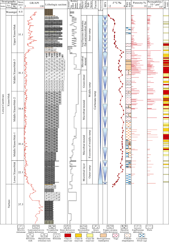
Fig. 2.
Composite stratigraphic column of the Xiaoerblak Formation in the DG-3 section.
Lower Xiaoerblak, 22.1 m thick on average, is mainly composed of blackish grey laminated to thin bedded microbial dolostone. Middle Xiaoerblak-1, 30.4 m thick on average, consists of dark grey thin bedded microbial dolostone with intra-stratal flat vugs of centimeter scale. Middle Xiaoerblak-2, 34.6 m thick on average, consists of grey bedded microbial dolostone with intra-stratal vugs of centimeter scale and dissolved pores of millimeter scale at the top. Middle Xiaoerblak-3, 36.1 m thick on average, is mainly made up of light grey to greyish white thick blocky grain/crystalline dolostone and microbial dolostone; there are abundant along bedding nearly round dissolved pores of millimeter scale in the middle microbial dolostone, while dissolved pores distributed unevenly in grain/crystalline dolostone. Upper Xiaoerblak, 34.1 m thick on average, is dominated by yellowish grey thin bedded argillaceous dolostone, grey bedded microbial dolostone, and interbedded grey to brownish grey thin bedded grained dolostone and micritic dolostone. Upper Xiaoerblak takes on saw-tooth shape on GR curve and shows higher GR values, while Middle and Lower Xiaoerblak show low GR values with small variation.
2.2. Sedimentation
The Xiaoerblak Formation in the study area is mainly composed of microbial dolostone, grain dolostone (GD), crystalline dolostone with grain ghost structure (CD), micritic dolostone (MD) and argillaceous dolostone (AD). Microbial dolostone is the main rock type[20,21,22] and includes laminated microbialite dolostone (LMD), thrombolite dolostone (TD), foamy-stromatolite dolostone (FSD), stromatolite dolostone (SD), and some oncolite dolostone (OD) (Fig. 3a-3i). Different lithofacies occur in specific layers, constituting a sedimentary sequence of microbial layers-microbial mounds/grain shoals-tide flat on the carbonate ramp.
Fig. 3.
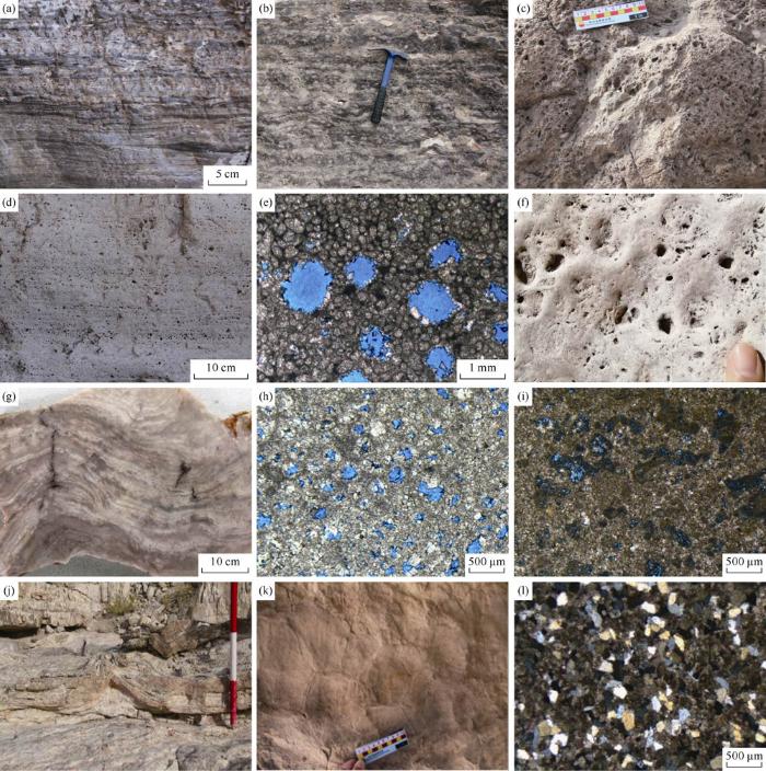
Fig. 3.
Types and features of Xiaoerblak Formation rocks in Kalpin outcrop area. (a) LMD, Lower Xiaoerblak, DG-3 section, outcrop; (b) Bedded TD, framework dissolved pores along bedding, Middle Xiaoerblak-1, DG-1 section, outcrop; (c) Frame-shaped TD, well-developed vugs, Middle Xiaoerblak-2, DG section, outcrop; (d) FSD, homogeneous dissolved pores, Middle Xiaoerblak-3, DG-3 section, outcrop; (e) FSD, relatively homogeneous fenestral pores, DG-3 section, Middle Xiaoerblak-3, cast thin section, plane-polarized light; (f) OD, well-developed intragranular dissolved pores, Middle Xiaoerblak-3, XG section, outcrop; (g) SD, Middle Xiaoerblak-3, XG-1 section, hand specimen; (h) CD, well-developed intragranular/intercrystalline dissolved pores, Middle Xiaoerblak-3, XG section, cast thin section, plane-polarized light; (i) GD, Upper Xiaoerblak, DG-3, cast thin section, plane-polarized light; (j) Tepee structure, Upper Xiaoerblak, SARK section, outcrop; (k) Mud cracks, Upper Xiaoerblak, DG-3, outcrop; (l) Quartzose micritic dolostone, Upper Xiaoerblak, DG-3 section, cast thin section, orthogonal light.
Lower Xiaoerblak is composed of blackish grey laminated to thin bedded LMD locally sandwiched with bedded CD, indicating an overall deep, still sedimentary environment with weak energy below the storm wave base on the outer ramp. Middle Xiaoerblak-1 and Middle Xiaoerblak-2 are mainly composed of dark grey to grey bedded to frame-shaped TD, indicating a sedimentary environment with medium energy below the wave base on the middle ramp. Middle Xiaoerblak-3 is mainly composed of light grey thick blocky GD and greyish white FSD mounds, and some shoals in which have cross beddings, suggesting a shallow high-energy sedimentary environment with strong hydropower close to the wave base on the middle ramp. Upper Xiaoerblak is composed of grey bedded to thin bedded SD and interbedded grey-light brownish grey-yellowish grey MD/AD, which constitute microbial dolomitic flat, argillaceous dolomitic flat, and low-energy shoals in a tide-flat environment. Some exposure markers, e.g. tepee structures, mud cracks, and hybrid quartz particles, can be observed in this member (Fig. 3j-3l). Facies sequences from the bottom up and GR logs indicate upward shallowing of seawater at the depositional stage of the Xiaoerblak Formation.
3. Reservoir rocks
3.1. Pore space
According to outcrop observation and cast thin section identification, pore space in Xiaoerblak Formation in the study area is composed of microbial framework (dissolved) pores (Fig. 3c), fenestral pores (Fig. 3d-3e), intergranular (intragranular) dissolved pores (Fig. 3f, 3i), and intercrystalline dissolved pores.
Intra-stratal irregular flat microbial framework (dissolved) pores, 1-3 cm in diameter, mainly occur in TD in Middle Xiaoerblak-1 and Middle Xiaoerblak-2. Such pores may also appear in local SD in Upper Xiaoerblak, but what we have observed is irregular belt-like residual framework pores partially cemented by fine-grained dolomite. Fenestral pores, which are isolated dissolved pores with 0.2-5.0 mm in diameter, homogeneously occur in FSD in Middle Xiaoerblak-3. Intergranular (intragranular) dissolved pores mainly exist in GD; heterogeneous dissolved pores of millimeter scale could be observed on outcrops. Intercrystalline dissolved pores, which are irregular in size and geometry, mainly occur in CD in Middle Xiaoerblak-3.
To examine the quality of reservoir rocks based on microscopic pore throat structure[23], 25 mm plugs of TD, FSD and CD with large matrix porosity were selected for CT quantitative characterization (Fig. 4). This work was accomplished by CNPC Key Laboratory of Carbonate Reservoirs using VtomeX, a customized instrument made in Germany. At the scanning resolution of 8 μm in 3D CT imaging, pores in TD sample observed show some directivity, which is related to microbial growth texture. The TD sample has a porosity of 2.49%, volume ratio with interconnected pores of 52.53%, small pore-throat radius differentiation, and pore radii of 30-100 μm. Vugs in such lithofacies are mainly of centimeter scale; thus, it is inferred that inter-pore matrix has some interconnectivity and porosity. As per comprehensive evaluation, these reservoirs are classified as porous and vuggy reservoirs with medium to high porosity and medium permeability. At the scanning resolution of 8 μm in 3D CT imaging, fenestral pores in FSD sample was observed to be isolated ellipsoids homogeneously scattering in the samples. The sample has an estimated porosity of 10.05%, volume ratio with interconnected pores of 39.54%, large pore-throat radius differentiation, and both large pores (with the radius above 200 μm) and small pores (with the radius of 50-100 μm). Through comprehensive evaluation, this type of reservoir is classified as porous and vuggy reservoir with high porosity and medium to low permeability. At the scanning resolution of 8 μm in 3D CT imaging, it is found that the CD sample contains intergranular dissolved pores in irregular net shape. The sample has an estimated porosity of 4.45%, volume ratio with interconnected pores of 64.24%, small pore-throat radius differentiation. Most intercrystalline dissolved pores are 30-120 μm in radius except some large dissolved pores. As per comprehensive evaluation, these reservoir rocks are classified as porous and vuggy reservoirs with medium porosity and permeability.
Fig. 4.
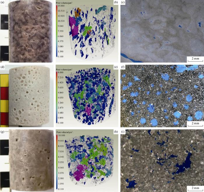
Fig. 4.
CT characterization of Xiaoerblak Formation dolostone reservoirs. (a) TD, Middle Xiaoerblak-2, DG-1 section, plug sample of 25 mm; (b) 3D CT image of the plug shown in Fig. a (different colors indicate different grades of pore volume); (c) Cast thin section photo of the sample shown in Fig. a; (d) FSD, Middle Xiaoerblak-3, SARK section, plug sample of 25 mm; (e) 3D CT image of the sample shown in Fig. d; (f) Cast thin section photo of the sample shown in Fig. d; (g) CD, Middle Xiaoerblak-3, XG-1 section, plug sample of 25 mm; (h) 3D CT image of the sample shown in Fig. g; (i) Cast thin section photo of the sample shown in (g).
3.2. Petrophysical properties
Altogether 556 plug samples were collected from all layers in Xiaoerblak Formation, including 128 samples from the SARK section, 91 from DG-3, 25 from DG-2, 77 from DG-1, 49 from DG, 122 from XG, and 64 from XG-1. Petrophysical properties of the samples were measured by CNPC Key Laboratory of Carbonate Reservoirs using the tester for gas porosity and permeability under overburden pressure. To better understand vertical reservoir distribution, we made statistical analysis of petrophysical properties for each layer (Fig. 5). The samples from Lower Xiaoerblak have maximum and minimum measured porosity values of 3.78% and 0.54%, respectively, and an average porosity of 1.33%. The samples from Middle Xiaoerblak-1 have maximum and minimum porosity values of 8.90% and 0.86% and an average porosity of 3.07%. The samples from Middle Xiaoerblak-2 have maximum and minimum porosity values of 8.06% and 0.61%, and an average porosity of 2.80%. The samples from Middle Xiaoerblak-3 have maximum and minimum porosity values of 10.92% and 0.70%, respectively and an average porosity of 3.39%. The samples from Upper Xiaoerblak have maximum and minimum porosity values of 7.81% and 0.64%, respectively and an average porosity of 1.53%. In short, the samples from Middle Xiaoerblak have better petrophysical properties, so it is the main reservoir section. To better understand lateral reservoir distribution, the numbers of samples with the porosity above 4.5%, between 2.5% and 4.5%, between 1.8% and 2.5%, and below 1.8%, were counted for each section. The histogram of porosity distribution (Fig. 6) shows that there are more high-quality reservoir rocks with the porosity above 2.5% in SARK, DG-3, and DG-2 than in other sections. In summary, 45.8% of the samples have porosity above 2.5%, and 23.9% of the samples have permeability above 0.1×10⁻³ μm2. These results indicate the Xiaoerblak reservoirs have medium to high porosity and medium to low permeability.
Fig. 5.
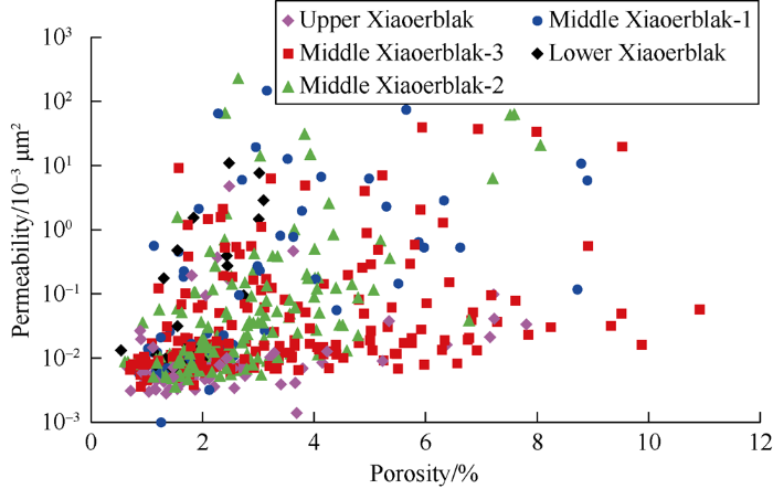
Fig. 5.
Porosity vs. permeability of Xiaoerblak reservoirs.
Fig. 6.
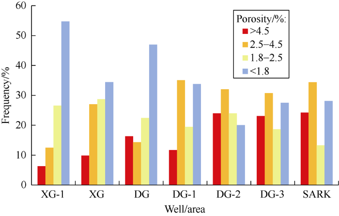
Fig. 6.
Porosity histogram of Xiaoerblak reservoirs.
4. Reservoir genesis
4.1. Dolomite genesis
Dolomite genesis can be inferred from its geochemical features. The dolomite samples of different lithofacies were taken by a roller bit for multi-parameter geochemical study. All the tests were made by CNPC Key Laboratory of Carbonate Reservoirs. The degree of order was tested with PANalytical X’Pert PRO X-ray diffractometer. Trace elements and rare earth elements were measured with PANalytical Axios XRF X-ray fluorescence spectrograph. Carbon and oxygen isotopes were tested with DELTA V Advantage isotope mass spectrograph. Strontium isotopic compositions were tested with TRITON PLUS thermoionization isotope mass spectrograph.
4.1.1. Order degree of dolomite
The order degree increases with temperature and decreases with dolomite crystalline growth velocity[24]. The histogram of order degree (Fig. 7) shows that 5 major lithofacies, i.e. LMD (2 samples), TD (2 samples), FSD, SD, and CD, generally exhibit low order degree, with the maximum value of 0.77, minimum value of 0.45, and average value of 0.60. This indicates the dolostone in Xiaoerblak Formation was formed in low temperature at high velocity of crystalline growth. In other words, Xiaoerblak dolostone is the product of early diagenesis.
Fig. 7.
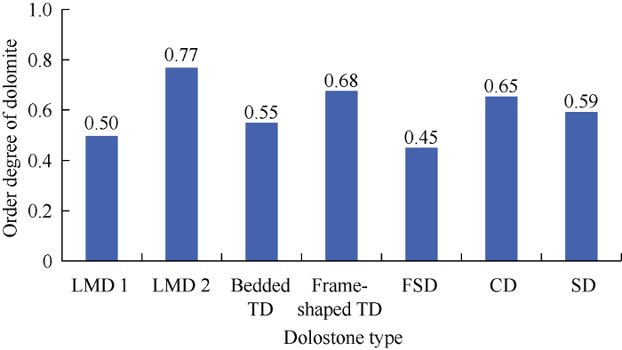
Fig. 7.
Order degree histogram of dolomite samples from Xiaoerblak Formation.
4.1.2. Trace elements
The contents of trace elements, including Sr, Na, Fe, and Mn, can indicate fluid properties and diagenetic environment in the process of dolomitization. The contents of Sr and Na in Paleozoic seawater are usually in direct proportion to seawater salinity[25]. Thus, the dolomitization fluid at the early diagenetic stage was seawater with relatively high Sr and Na contents, while dolostone forming at the late burial stage has low Sr content below 50×10-3 mg/g and low Na content below 100×10-3 mg/g. In contrast, dolomite forming at the Earth's surface or at the early burial stage has relatively low Fe and Mn contents, and dolomite forming at the late burial stage has relatively high Fe content above 2 000×10-3 mg/g and high Mn content above 500×10-3 mg/g[26,27]. Twelve dolostone samples of different lithofacies have a Sr content range of (59.8-135.2)×10-3 mg/g and a Na content range of (237.45-1 049.7)×10-3 mg/g, Fe content range of (206.45-1339.40)× 10-3 mg/g and Mn content range of (90.4-373.0)×10-3 mg/g, respectively. The abnormally high Fe contents of No. 11 and 12 samples are related to the high shale content in an oxidizing environment in the supratidal zone (Table 1). Xiaoerblak dolostone samples in the study area have high Sr and Na contents and low Fe and Mn contents, indicating that the dolomitization was caused by seawater at the early diagenetic stage, while the effect of hydrothermal activities at the late burial stage was weak.
Table 1 Test results of trace elements of samples from Xiaoerblak Formation.
| Layer | Lithology | Content/(10-3 mg·g-1) | |||
|---|---|---|---|---|---|
| Sr | Na | Fe | Mn | ||
| Lower Xiaoerblak | LMD 1 | 111.8 | 396.50 | 276.10 | 180.0 |
| LMD 2 | 108.2 | 408.50 | 1 339.40 | 283.0 | |
| Middle Xiaoerblak-1 | Bedded TD 1 | 159.1 | 626.25 | 841.85 | 271.0 |
| Bedded TD 2 | 63.8 | 390.15 | 1 299.65 | 322.0 | |
| Middle Xiaoerblak-2 | Frame- shaped TD | 107.8 | 506.75 | 1 217.90 | 205.0 |
| Middle Xiaoerblak-3 | CD | 59.8 | 382.55 | 1 056.40 | 157.0 |
| GD | 72.8 | 973.10 | 583.35 | 141.0 | |
| FSD | 78.5 | 237.45 | 206.45 | 90.4 | |
| Upper Xiaoerblak | SD | 93.8 | 314.35 | 1187.85 | 150.0 |
| GD | 135.2 | 1049.70 | 9248.70 | 373.0 | |
| AD | 88.8 | 676.80 | 15743.90 | 148.0 | |
4.1.3. Rare earth elements
Diagenesis has very little effect on rare earth elements in carbonate minerals, hence we can use rare earth elements to tell the origin of dolomitization fluids. The dolostone originating from Cambrian seawater has ∑REE value of (total REE content) less than 30×10-6, and higher content of light rare earth elements than heavy rare earth elements in general[28]. Experimental results (Fig. 8) show that except for two argillaceous dolostone samples from Upper Xiaoerblak with high ∑REE of (90.2-99.3)×10-6 due to the impact of terrigenous mudstone, the rest samples of different lithofacies have a ∑REE range of (1.8-31.3)×10-6 and an average ∑REE of 8.7×10⁻⁶; higher contents of light rare earth elements than heavy rare earth elements from REE distribution pattern curves. This pattern of REE distribution is similar to that of Cambrian micrite limestone[29]. This means that dolomitization of Xiaoerblak Formation was caused by seawater and the diagenesis at the late burial stage did not change the distribution of rare earth elements significantly.
Fig. 8.
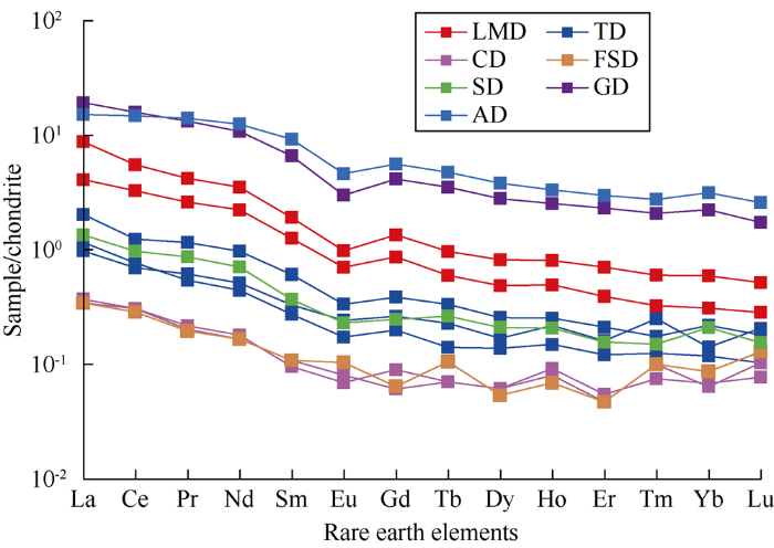
Fig. 8.
Distribution of rare earth elements in the dolostone samples.
4.1.4. Stable carbon and oxygen isotopic compositions
Due to seawater evaporation, carbon and oxygen isotopic composition will move toward the positive side; in contrast, the effects of subsurface brine and high temperature in a burial condition will make oxygen isotopic composition move toward the negative side[30]. Matrix and cement samples were drilled with a roller bit from dolostone of different lithofacies to test stable carbon and oxygen isotopic compositions. The matrix samples of different lithofacies dolostone in different layers have a δ18O range between -8.24‰ and -5.41‰ and a δ13C range between -3.39‰ and -0.78‰. The dolomite cement samples from pores and vugs have a δ18O range between -12.02‰ and -10.14‰ and δ13C range between 0.32‰ and 0.52‰. The calcite cement samples from pores and vugs have a δ18O range between -15.27‰ and -11.14‰ and a δ13C range between -4.28‰ and -1.69‰. It can be seen from the δ18O- δ13C cross-plot (Fig. 9) that there is a non-linear relationship between the values of δ18O and δ13C, indicating that the test data is reliable. Through statistics of global δ18O data, Veizer concluded that seawater in the Early-Middle Cambrian had a δ18O range from -8‰ to -6‰[31], which is equivalent to the δ18O value of the Xiaoerblak Formation. This implies that the Xiaoerblak dolostone is generated at low temperature from dolomitization caused by normal seawater. The dolomite cement samples from pores and vugs have negative δ18O values below -10‰, indicating they are diagenetic product of high temperature at the late burial stage. Whereas the negative δ13C values of calcite cement samples suggest the calcite is of meteoric water origin.
Fig. 9.
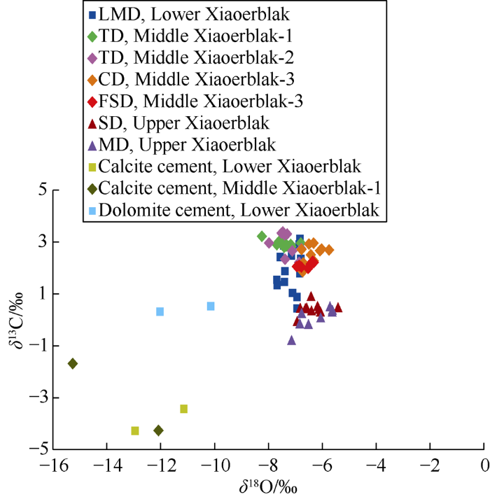
Fig. 9.
δ18O-δ13C crossplot of dolostone samples.
4.1.5. Strontium isotopic composition
Water evaporation has little impact on Sr isotopes; this means that dolostone forming in an evaporitic environment has the same Sr isotopic composition with that of seawater. Relative 87Sr abundance is characterized by 87Sr/86Sr ratio. Through statistics on global 87Sr/86Sr data, Denison proposed that 87Sr/86Sr ratio of seawater in the Early-Middle Cambrian Epoch was around 0.709 0[32]. Test results (Table 2) show that the dolostone samples of different lithofacies in different layers have a main range of 87Sr/86Sr ratio from 0.708 8 to 0.709 8, close to the values of seawater in the same period, indicating that the dolomitization took place in seawater at the early diagenetic stage. The two samples from Upper Xiaoerblak have 87Sr/86Sr ratios above 0.713 2, suggesting the dolostone was affected by shell-origin strontium in the process of dolomitization, and was formed in an exposure oxidizing environment at the early hypergenic stage.
Table 2 Strontium isotopic data of Xiaoerblak Formation dolostone samples.
| Lithology | Layer | 87Sr/86Sr | Standard deviation/10-6 | Lithology | Layer | 87Sr/86Sr | Standard deviation/10-6 | |
|---|---|---|---|---|---|---|---|---|
| LMD | Lower Xiaoerblak | 0.709 821 | 7 | GD | Middle Xiaoerblak-3 | 0.709 324 | 8 | |
| LMD | Lower Xiaoerblak | 0.709 374 | 3 | GD | Middle Xiaoerblak-3 | 0.709 412 | 6 | |
| LMD | Lower Xiaoerblak | 0.708 945 | 9 | GD | Middle Xiaoerblak-3 | 0.709 113 | 17 | |
| LMD | Lower Xiaoerblak | 0.708 992 | 8 | FSD | Middle Xiaoerblak-3 | 0.709 105 | 6 | |
| Bedded TD | Middle Xiaoerblak-1 | 0.709 811 | 5 | CD | Middle Xiaoerblak-3 | 0.709 122 | 8 | |
| Bedded TD | Middle Xiaoerblak-1 | 0.709 289 | 13 | SD | Upper Xiaoerblak | 0.709 787 | 5 | |
| Bedded TD | Middle Xiaoerblak-1 | 0.708 843 | 6 | AD | Upper Xiaoerblak | 0.713 343 | 11 | |
| Frame-shaped TD | Middle Xiaoerblak-2 | 0.709 257 | 4 | GD | Upper Xiaoerblak | 0.713 218 | 2 | |
| Frame-shaped TD | Middle Xiaoerblak-2 | 0.709 089 | 4 | MD | Upper Xiaoerblak | 0.708 946 | 8 |
As the Xiaoerblak Formation in the study area is mainly composed of microbial dolostone, some researchers proposed that microbial actions caused the dolomitization there. But we don’t think there is enough evidence supporting this point. This is because: (1) Both microbial lithofacies and sediments of shoal facies in Xiaoerblak Formation in the study area experienced dolomitization; this cannot be explained by microbial action. (2) Globally, dolostone accounts for a very high percentage in the Lower Cambrian Series. This was explained previously by large-scale dolomitization caused by evaporation in shallow carbonate platforms in the geologic seawater and climate conditions in the Early Cambrian Epoch[33,34]. Therefore, based on petrological and geochemical features, we concluded that Xiaoerblak dolostone was mainly formed at the penecontemporaneous or early burial stage and the fluids causing dolomitization were mainly of marine origin. In view of the geologic setting of carbonate ramps in the Early Cambrian Epoch, the dolostones in Xiaoerblak Formation are likely formed by evaporation dolomitization and seepage reflux dolomitization.
4.2. The controlling effects of early dolomitization on reservoirs
It is well known that dolomitization can make limestone change completely into dolostone, and the lithologic composition and fabric of the original rock alter. As dolostone has higher resistance to compaction and pressure solution, dolomitization at the penecontemporaneous or early burial stage could help the preservation of primary pores and early secondary dissolved pores. Moreover, simulation experiments of pressure solution at high temperature and pressure show that dolostone is more soluble than limestone at large buried depth. This means in addition to preexisting pores, dolostone may be further reformed to have more pore space at the late stage[10]. Dolostone in Xiaoerblak Formation in the study area was formed at the early diagenetic stage; thus, framework pores and intergranular pores forming in the process of microorganism accumulation at the depositional stage and fenestral pores and intergranular (intragranular) dissolved pores formed by meteoric water dissolution at the penecontemporaneous stage may still be partially preserved after a long period of burial.
4.3. The controlling effects of lithofacies on reservoirs
Different layers in Xiaoerblak Formation have different lithofacies and reservoir properties. The Middle Xiaoerblak has better petrophysical properties than the Upper and Lower Xiaoerblak. This means there is a good correlation between lithofacies and reservoir porosity. To confirm the correlation between porosity and lithofacies of the reservoirs, the petrophysical properties of all the samples were counted by lithofacies (Fig. 10). It can be seen that the LMD samples from Lower Xiaoerblak have a maximum and average porosity of 2.74% and 1.41%; bedded TD samples from Middle Xiaoerblak-1 have a maximum and an average porosity of 8.90% and 3.07%; frame-shaped TD samples from Middle Xiaoerblak-2 have 8.06% and 2.80%. For Middle Xiaoerblak-3, the maximum and average porosity are 9.52% and 2.58% for GD (including CD), 10.92% and 4.70% for FSD, 5.25% and 3.02% for OD, 4.15% and 2.21% for SD, and 1.54% and 1.02% for MD (including AD). Apparently, the reservoir porosity and lithofacies in Xiaoerblak Formation have a good correlation. FSD has the highest porosity, followed by TD, OD, and GD (including CD). Hence, lithofacies is one factor controlling reservoir properties.
Fig. 10.

Fig. 10.
Porosity of dolostone reservoirs of different lithofacies in Xiaoerblak Formation.
4.4. The controlling effects of high-frequency sequence on reservoirs
Porosity distribution in Xiaoerblak Formation has some cyclicity, and better reservoirs occur in some specific layers. Generally speaking, reservoirs in TST are poorer in properties, and have weak correlation with sea level cycles. Reservoirs in HST have higher porosity because microbialite and grain shoals might be exposed to meteoric water and experience leaching[35]. Therefore, the reservoir development is correlated with sea level cycles. For Middle Xiaoerblak-1 and Middle Xiaoerblak-2, which are both composed of TD, but the framework dissolved pores in them are not evenly distributed, rather the vuggy layers alternate with tight layers in them. In Middle Xiaoerblak-3, pores in GD (including CD) and FSD aren’t distributed evenly or randomly, rather the porous layers alternate with tight layers. This means porosity change in the same lithofacies is related to high-frequency sequence boundaries.
In spite of mass pores and vugs in Middle Xiaoerblak, we can hardly find typical markers of surfaces of depositional break or exposed surfaces. Negative δ13C is generally regarded as an indicator of exposure. Therefore, δ13C of 89 samples from the DG-3 section were tested to build a δ13C profile (Fig. 2). It can be seen from this figure that there are a number of data points with negative δ13C in Middle Xiaoerblak, which correlate with the intervals with high porosity. Thus, negative δ13C may be taken as an indirect indicator of short-term exposure at the penecontemporaneous stage. This means that high-frequency sequence boundaries are one of the controlling factors for reservoir properties.
In summary, good lithofacies are the basis of reservoir development in Xiaoerblak Formation of the study area; meteoric water dissolution at the early hypergenic stage is crucial to reservoir development; and early dolomitization can help preserve primary pores.
5. Reservoir geological modeling and its significance
5.1. Sedimentary microfacies model
According to the characteristics of microfacies in 7 outcrop sections both in vertical and lateral directions, we built a sedimentary microfacies model for the Xiaoerblak Formation in the study area. Laminated microbialite strata mainly appear on the outer ramp, thrombolite mounds occur in the exozone of the middle ramp, grain shoals and foamy-stromatolite mounds occur in middle ramp, stromatolite flats and argillaceous dolomitic flats appear on the inner ramp. All the microfacies are stable in thickness and continuous laterally, reflecting relatively sustained sedimentation in the carbonate ramp. But there are some differences, a major difference is that the XG-1 section has a higher proportion of grain shoals than the other sections, and has no foamy-stromatolite mounds in Middle Xiaoerblak-3. In view of the existence of the Wensu paleohigh in the northwest of the outcrop area, it is inferred from well data that the microbial mounds-dominated sedimentary system on the middle ramp gradually changes into the grain shoals-dominated sedimentary system from the paleohigh to platform[36].
5.2. Reservoir model
In accordance with petrophysical properties derived from 7 sections, cast thin section data, and vuggy intervals in outcrop sections, we built a reservoir geological model for the Xiaoerblak Formation in the study area (Fig. 11). Apparently, reservoirs mainly occur in TD, GD (including CD), and FSD in Middle Xiaoerblak, and show features of sedimentary facies control, segmentation, and cyclicity, which indicates that the reservoirs are controlled by sedimentary facies, microbial types or high-frequency sequence boundaries. According to petrophysical properties and carbonate reservoir evaluation criterion for the Tarim oilfield (porosity above 4.5% and permeability above 3×10⁻³ μm2 for class-I reservoirs; porosity of 2.5%- 4.5% and permeability of (0.1-3.0)×10-3 μm2 for class- II reservoirs; porosity of 1.8%-2.5% and permeability of (0.01- 0.10)×10-3 μm2 for class-III reservoirs; porosity below 1.8% and permeability below 0.01×10⁻³ μm2 for non-reservoirs), the reservoirs in all members were evaluated and their thicknesses counted (Table 3). The results show that the SARK section has the thickest class-I and class-II reservoirs of 65.6 m, and reservoir-formation thickness ratio of 41.2%; the DG-3 section is second with a reservoir thickness of 51.5 m and reservoir-formation thickness ratio of 32.5%; and the XG-1 section has the smallest reservoir thickness of 16.1 m and a reservoir-formation thickness ratio of 12.2%. The 7 sections have an average high-quality reservoir thickness of 41.2 m and average reservoir-formation thickness ratio of 25.6%.
Fig. 11.

Fig. 11.
Geological model of the Xiaoerblak Formation reservoir in Kalpin outcrop area.
Table 3 Reservoir thickness in the Xiaoerblak Formation.
| Section | Thickness/m | Class-I and class-II reservoir- formation thickness ratio/% | ||
|---|---|---|---|---|
| Class-I | Class-II | Class-III | ||
| XG-1 | 3.0 | 13.1 | 45.7 | 12.2 |
| XG | 10.3 | 31.1 | 43.7 | 26.8 |
| DG | 9.2 | 33.9 | 31.5 | 24.2 |
| DG-1 | 10.9 | 31.7 | 30.3 | 25.3 |
| DG-2 | 12.3 | 16.3 | 38.4 | 17.1 |
| DG-3 | 30.0 | 21.5 | 35.4 | 32.5 |
| SARK | 32.5 | 33.1 | 24.9 | 41.2 |
5.3. Significance to exploration
The reservoir geologic model built based on outcrops shows that the Xiaoerblak Formation in the Tarim Basin contains high-quality reservoirs of considerable scale and predictability; and high-quality reservoirs are concentrated in mounds and shoals on the middle ramp in the periclinal area around the paleohigh. Thus, we predicted three promising zones for exploration, i.e. grain-bank reservoir belt in Tazhong- Badong, mound-shoal reservoir belt in Kalpin-Bachu, and mound-shoal reservoir belt in Yaha and Lunnan. Based on the better understandings of sedimentation and reservoir rocks in the sub-salt Cambrian System, Wells Chutan1, Hetian2, and Honghan1 were drilled, which revealed high-quality reservoirs of 54.0 m, 47.0 m, and 32.0 m thick, respectively in Xiaoerblak Formation. Consequently, Tarim Oilfield Company set the sub-salt Cambrian System as one of the three major targets of risk exploration.
6. Conclusions
The Xiaoerblak Formation in the Kalpin outcrop area is divided into 3 members and 5 sub-members, and consists of LMD, TD, FSD, SD, OD, CD, GD, MD and AD. Lithofacies sequence from the bottom up constitutes a sedimentary system mainly composed of microbial strata-microbial mounds/grain shoals-tide flat on the carbonate ramp. There are 5 types of pore space in the reservoirs, i.e. microbial framework dissolved pores, vugs, intergranular/intragranular dissolved pores, and intercrystalline dissolved pores. The porosity is closely related to lithofacies. FSD exhibits the highest average porosity of 4.7%, followed by TD, OD, GD and CD with average porosities of 2.58-3.07%. The reservoirs were classified as porous and vuggy ones with medium to high porosity and medium to low permeability. Low dolomite order degree, high Sr and Na contents, low Fe and Mn contents, same REE distribution pattern with Cambrian micrite, and δ18O and 87Sr/86Sr similar to those of Cambrian seawater show that dolomitization of Xiaoerblak Formation was caused by fluids of marine origin at the penecontemporaneous-early diagenetic stages. Negative δ13C indicates short-term exposure at the penecontemporaneous stage. The reservoir development is controlled by sedimentary facies, microorganisms, high-frequency sequence boundaries and early dolomitization jointly. High- quality reservoirs of class-I and class-II are 41.2 m thick on the average, and the average reservoir-formation thickness ratio is 25.6%, indicating the reservoir is of considerable scale and exploration potential. We predicted that high-quality reservoir may develop in the mounds and shoals of middle ramp in the periclinal area around the paleohigh.
Reference
Oil-gas exploration prospect of dolomite reservoir in the Lower Paleozoic of Tarim Basin
Characteristics and controlling factors of the large carbonate petroleum province in the Tarim Basin, NW China
Discovery and exploration of Cambrian subsalt dolomite original hydrocarbon reservoir at Zhongshen-1 well in Tarim Basin
Accumulation conditions and play targets of oil and gas in the Cambrian subsalt dolomite, Tarim Basin, NW China
Deep or super-deep dolostone reservoirs: Opportunities and challenges
Review and prospectives of microbial carbonate reservoirs

Microbial carbonates are important oil & gas reservoir rocks, as well as the main rock types in China old strata. Microbial carbonates can be divided into stromatolites, thrombolite,dendrolite and other two types. The reservoir pore systems are closely related to microbialite sedimentary process, and mostly affected by structures and textures of microbialites. Framework and fenestral vugs are the main types of reservoir space. From Middle-Neo Proterozoic to Mesozoic, microbial carbonates reservoirs are discovered globally in various oil & gas fields, so that their petroleum resource potential is great.The researches on rock types,litofacies texture, depositional models and favorable facies zones of microbial reservoir, are well worth deep study in future.
Reservoirs of lower Cambrian microbial carbonates, Tarim Basin, NW China
The reservoir modeling of platform margin dolostone of Xiaoerblak Formation, Lower Cambrian, Kaping Area, Tarim Baisn
Reservoirs of the Lower Cambrian microbial reefs and its significance on petroleum exploration, Tarim Basin, NW China
Characteristics, origin and distribution of dolomite reservoirs in Lower-Middle Cambrian, Tarim Basin, NW China
Sedimentary characteristics of intra-platform microbial mounds and their controlling effects on the development of reservoirs: A case study of the Lower Cambrian Xiaoerbulake Fm. in the Keping-Bachu Area, Tarim Basin
Structure characteristics and major controlling factors of platform margin microbial reef reservoirs: A case study of Xiaoerbulak Formation, Lower Cambrian, Aksu Area, Tarim Basin, NW China
Characteristics and genesis of dolomite reservoir in the lower Cambrian Xiaoerblak Formation, Tarim Basin
Influence of microbial textures on pore characteristics of microbial dolomites: A case study of lower Cambrian Xiaoerbulake Formation in Keping Area, Tarim Basin
Paleozoic sediment- tectonic evolution and basin dynamic settngs in Wushi-Kalpin- Bachu Area, northwest Tarim
The north-south differentiation characteristic and its enlightenment on oil-gas exploration of the Noeoproterozoic rift basin, Tarim Basin
Lithofacies paleogeography of Cambrian sequences in the Tarim Basin
The tectonothermal events, architecture and evolution of Tarim craton basement palaeo-uplifts
The characteristics of Precambrian sedimentary basin and the distribution of deep source rock: A case study of Tarim Basin in Neoproterozoic and source rocks in Early Cambrian, Western China
Microbial carbonates: The geological record of calcified bacterial-algal mats and biofilms
Mircobial carbonate abundance compared with fluctuations in metazoan diversity over geological time
DOI:10.1016/j.sedgeo.2005.12.015 URL [Cited within: 1]
Mesozoic reefal thrombolites and other microbolites: RIDING R. Microbial sediments
Microstructure characterization based on CT imaging technology of Cambrian dolomite reservoir in Tarim Basin
Using multi-parameter comprehensive method to identify the genesis of lower Paleozoic dolomite in Tarim Basin
Comparative study on geochemical behaviors of dolomite reservoirs in northeast Sichuan Basin
Carbonate sedimentology
Characteristics and pore genesis of Penglaiba Formation dolomite in Keping-Bachu outcrop area
REE models for the discrimination of fluids in the formation and evolution of dolomite reservoirs
Genesis of dolomite and main controlling factors of reservoir in Penglaiba Formation of Lower Ordovician, Tarim Basin: A case study of Dabantage outcrop in Bachu Area
Dolomite reservoir is a potentially important exploration field in Cambrian-Lower Ordovician of Tarim Basin, but because of deeply buried and low exploration and research degree, the current understanding unable to meet the needs of the exploration, especially the main controlling factors and distribution rules of dolomite reservoir. This paper takes the dolomite reservoir in Penglaiba Formation of Dabantage outcrop in Bachu area as an example, measured 9 section, collected 195 samples and studied the characteristics of thin sections, physical properties and geochemistry systematically, and gets tow new understanding. Firstly, powder dolomite, fine dolomite, medium dolomite and coarse dolomite are the four dolomite types in research area, the dolomitization took place in the shallow-medium burial phase, the dolomitization fluid is mainly sea water, and some dolomites influenced by hydrothermal. The size of crystals is associated with the size of structure and pore space of protolith. Secondly, the distribution of pores has stratification and cyclicity, the pores mainly occur in the top of upward shallowing sequences, and their formation is relate to exposure. The main carrier of pores is fine-coarse dolomite, the pores are mainly from the pores of original rock or their readjustment, and just a few pores are from burial solution. It is different from conventional opinion which is pores are mainly formed by dolomitization, and this opinion is of a great significance for guiding the prediction of dolomite reservoir in Tarim Basin.
Carbonate reservoirs-porosity evolution and digenesis in a sequence stratigraphic framework
87Sr/ 86Sr, 13C and 18O evolution of Phanerozoic seawater
Construction of the Cambrian and Ordovician seawater 87Sr/ 86Sr curve
Master control factors of deep high-quality dolomite reservoirs and the exploration significance
Main controlling factors and characteristics of Cambrian dolomite reservoirs related to evaporite in Tarim Basin
Massive dolomites are widely distributed in the Cambrian System of Tarim basin, and in Middle Cambrian with thick evaporite, evaporite and dolomite can be good reservoirseal assemblage, so the dolomite strata is a new exploration field of Tarim Basin in the future. Sabkha dolomite and seepage reflux dolomite are the two kinds of dolomite related to evaporite, and the main controlling factors of reservoir are also associated with evaporite directly or indirectly. This article summarized the petrologic and geochemical characteristics of sabkha dolomite and seepage reflux dolomite by analyzing a lot of cores, thin sections, major element, REE and stable isotope (carbon, oxygen and strontium) data. The lithology of sabkha dolomite reservoir characterized by the deposits of gypsodolomicrite, gypsum mould pores and intergravel pores of solutioncollapse breccia are the two kinds of porosity, sabkha dolomitization, gypsum precipitation and dissolution of meteoric freshwater are the main controlling factors of this reservoir; The lithology of seepage reflux dolomite reservoir featured by crystal powder dolomite which has reserved the original grainstone or algae mound structure, intergranular pores, mould pore, framework pores and organism pores are the main kinds of porosity, seepage reflux dolomitization and meteoric freshwater dissolution are the main controlling factors of this reservoir; The distribution law of these tow dolomite reservoirs are controlled by sedimentary facies, and chiefly developed in arid climate background of middle Cambrian, Tarim basin.
Geological conditions and distributional features of large-scale carbonate reservoirs onshore China, NW China
Based on well cores and thin section observations of more than 300 wells from major exploration target areas and formations in the Tarim, Sichuan and Ordos Basins, combined with seismic, well logging and testing data, the types and characteristics of carbonate reservoirs as well as the geologic conditions for their extensive development are analyzed systematically, and their distribution features are summarized. All varieties of marine carbonate reservoirs are developed in China, including three types of large-scale effective reservoirs, which are (1) depositional reef-shoal and dolomite reservoirs, (2) epigenetic dissolution-percolation reservoirs and (3) deep burial-hydrothermal altered reservoirs. Besides sedimentary facies, paleoclimate and paleogeomorphy, other factors controlling the development of deep large-scale effective reservoirs include interstratal and intrastratal dissolution-percolation and burial dolomitization which can be impacted by hydrothermal processes. Large effective reservoirs in deep carbonate rocks are distributed along unconformities and hiatuses in sedimentation, while reservoirs of epigenetic dissolution-percolation type extend from paleohigh uplift zones to lower slope reliefs. The reservoirs are widely distributed in stratified planar forms, and are superposed by multi-stage karstification processes vertically and have obvious heterogeneity controls. Burial dolomitization is restricted by primary sedimentary facies, and can form extensive effective reservoirs in deep layers in layered or stratified shapes. Hydrothermal related reservoirs are always distributed along deep, large faults, forming effective reservoirs in the form of a bead string in vertical direction and band-rod horizontally, which are not restricted by burial depth.
Reservoir modeling of low Cambrian Xiaoerblak Formation in Sugaitblak Section and its significance on exploration regions, Tarim Basin, NW China
