


Introduction
The continuous collision and convergence between the Indian and Eurasian plates in the Early Cenozoic caused the rejuvenation of the Paleozoic South Tianshan orogenic belt. This led to large-scale overthrust to the Tarim Basin, north- south trend crustal shortening, and the formation of the fold and thrust belt in the front of the current South Tianshan[1,2,3,4,5,6,7]. The fold-and-thrust belt in front of the South Tianshan has clear structural features of north-south zonation and east-west segmentation in the horizontal direction[8,9], and it can be divided into the Kuqa, Wushi, Keping and Kashi segments in the EW direction. There are differences in the deformation style of each segment, especially the Kuqa segment where due to the distribution of gypsum-salt bed that serves as decollement, this segment differs widely in structural deformation from east-to-west[10,11,12]. The Wushi segment on the west of the Kuqa segment is an important part of the fold-and- thrust belt in front of the South Tianshan. Its deformation features that the front thrust fault (the Gumubiezi Fault, GF) slided along the ductile decollement (gypsum bed) and broke through the surface at the region where the Wensu uplift developed. This resulted in the formation of the Gumubiezi anticline in the hanging wall of the GF, thereby reforming the Wensu North fault, and gave rise to the Gumubiezi structural belt (GSB).
The GSB is divided into the eastern and western segments, which have clear spatial structural differences: namely, the large-scale breakthrough of the GF in the eastern segment and the disappearance of the GF in the western segment. Hence, several questions arise: why does the GF disappear from east to west; what mechanism works behind this; what factors control the structural difference between the eastern and western segments of the GSB; and how do the two segments achieve structural transformation? Solving those problems will help further reveal the basin-range coupling between the South Tianshan and Tarim Basin and structural transformation of thrust deformation. Answers to these questions will also contribute to our understanding of the formation and tectonic evolution of the Wushi sag, and guide the future exploration and development of new areas in the Tarim Basin.
Previous researchers reached different understandings, namely, back thrust structure[13,14] and detachment thrust fault[15,16,17,18,19], on the nature of the GF fault, the main fault in the GSB. One kind of view about the GF is that it is located in the upper structural layer of the Wushi Sag and is dominated by back thrust structure, and the lower structural layer is a basement-involved ramp structure[13,14]. However, this kind of interpretation cannot restore the seismic profile. The other view is that the GF develops within the Cenozoic and it is a detachment thrust fault with a large fault displacement[15,16,17,18,19], and the fault is a rootless fault. But this cannot explain the dynamical mechanism of the GF. Based on two-dimensional seismic profile, drilling data and field geological survey, this paper presents a detailed structural analysis of the Gumubezi tectonic belt from east to west, a regional tectonic geological cross section, and geometric and kinematic quantitative analysis of faults. Combined with the structural deformation and sedimentary characteristics of the eastern and western segments of the GSB, the structural transformation relationships between these two segments have been further analyzed.
1. Geological background
The GSB is located in the northwestern margin of the Tarim Basin, adjacent to the Wushi sag in the north, near the Wensu uplift in the south, adjacent to the Awate structural belt in the northeast, and extending to the Kalpin uplift in the southwest (Fig. 1). It plays an important controlling role in the Wushi sag. Two wells, XWD1 and XWD2, drilled in the margin of the Wensu uplift, northwest Tarim Basin, in 2017, obtained high yield industrial oil flow[20]. Two more wells, GM1 and WT1, were drilled in the margin of the GSB.
Fig. 1.
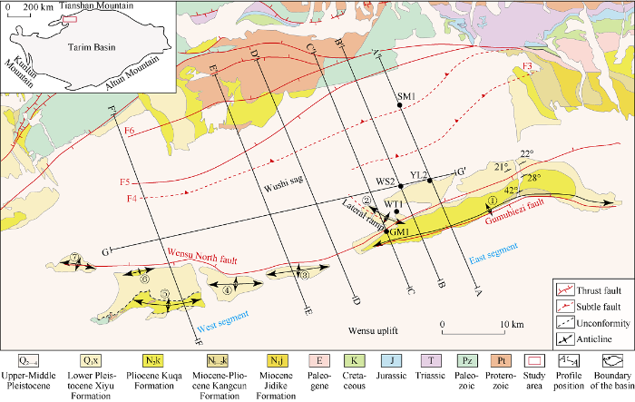
Fig. 1.
Geological map of the Gumubiezi structural belt. ① Gumubiezi anticline; ② Tieliemixi anticline; ③Woyitati’er anticline; ④ DongSu’ergun anticline; ⑤ Su’ergun anticline; ⑥ Bei’ergun anticline; ⑦Yangniawati anticline. F3—Xiatagake fault; F4—Tamlek fault; F5—Shenmuyuan South fault; F6—Shenmuyuan fault.
This structural belt includes the GF, the Wensu North fault, the Gumubiezi anticline, the Tieliemixi anticline, Woyitati’er anticline, Dongsurgun anticline, Surgun anticline, Bei’ergun anticline and Yangniawati anticline. The structural belt is distributed in a NEE direction as a whole, with a length of about 81 km from east to west and a width of about 12 km from north to south. The GF is a high angle thrust fault with fault plane dipping north at the dip angle of 45°-60°. It slipped along the gypsum bearing mudstone in Neogene Jidike Formation (N1j), and broke out of the surface at the region where the Wensu uplift developed, forming the Gumubiezi anticline in the hanging wall of the GF. The Gumubiezi anticline is NEE to EW trend, and protrudes toward north in the middle, with an extension of about 43 km on the surface. The Kangcun Formation (N1-2k) crops out of surface at the core of the anticline, and the Kuqa Formation (N2k) and Xiyu Formation (Q1x) developed from the core to the wings of the anticline. NW trend Tieliemixi anticline developed near Well GM1. The western segment of the GSB includes the Wensu North fault and a series of small anticlines in en echelon formation, Woyitati’er anticline, DongSu’ergun anticline, Su’ergun anticline, Bei’ergun anticline and Yangniawati anticline. Except the Su’ergun anticline and Bei’ergun anticline, the other small anticlines are covered by conglomerates of the Xiyu Formation. Among them, the Neogene Kuqa Formation exposes at the core of the Su’ergun anticline, and Kuqa Formation and Xiyu Formation are in unconformable contact.
The Proterozoic, Paleozoic, Mesozoic and Cenozoic expose in the Wushi segment. Drilling data reveals that there develop the Proterozoic, Triassic, Cretaceous, Paleogene, Neogene and Quaternary from the bottom to the top in the basin. Five wells are available to calibrate seismic horizons in the east segment of the GSB. Drilling data of YL2 and WS2 show that the Paleogene Kumugeliemu Group in them has only mudstone and sandstone sections in the upper part, a conglomerate section at the bottom, no salt layers, and overall granularity of positive rhythm. The Kumugeliemu Group here does not have gypsum- salt bed that can serve as a decollement. However, the Neogene Jidike Formation has thick gray mudstone and gypsum- bearing brown mudstone developed (Fig. 2). Unlike the Quele area in Kuqa depression with widespread Kumugeliemu group salt decollement[21,22], the gypsum mudstone in the Neogene Jidike Formation serve as the decollement in this study area.
Fig. 2.
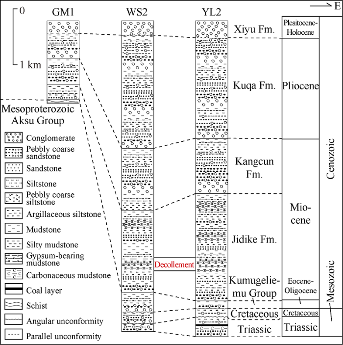
Fig. 2.
Stratigraphic column through wells in the Gumubiezi structural belt.
2. Deformation of the Gumubiezi structural belt
To better explain the deformation characteristics of the Gumubiezi structural belt, we examined six two-dimensional N-S trend seismic reflection profiles which pass through the South Tianshan, Wushi sag, GSB and the Wensu uplift. The original data of these profiles were post-stack time migration transects. The layer velocities of strata in the study area were collected and then the six profiles were converted from time domain to depth domain. The velocities of the strata used in the time-depth conversion were the average velocities of the strata. Velocity values of the layers were as follows: 2500 m/s for the air layer, 2600 m/s for the Quaternary, 2800 m/s for the Kuqa Formation, 3000 m/s for Kangcun Formation, 3500 m/s for Jidike Formation, 3600 m/s for Paleogene, 3800 m/s for Cretaceous, and 4000 m/s for Triassic, Paleozoic and Proterozoic. The air layer refers to the section above the surface.
2.1. Structural deformation of the eastern segment of the Gumubiezi structural belt
2.1.1. Structural characteristics on regional profiles
A-A′, B-B′, and C-C′ are three regional profiles which pass through the Tianshan, Wushi sag, and Wensu uplift in the eastern segment of the GSB (Figs. 3, 4, and 5). The structure of the regional profile can be divided into the following three units from north to south: (1) the South Tianshan thrust system in Paleozoic controlled by the high-angle basement thrust; (2) the Wushi sag and the duplex structure in its deep part composed of Paleozoic-Mesozoic thrusts; and (3) the Wensu North fault that thrusts northward, the GF and anticline on the hanging wall of the GF (all of which constitute the east segment).
The South Tianshan thrust system is composed of the high- angle thrust Shenmuyuan south fault and the Shenmuyuan fault. Low-temperature thermochronological study results of the South Tianshan and its surrounding regions indicate that the South Tianshan thrust system started initial activity in the Late Oligocene[23,24,25]. At that time the Shenmuyuan fault and the Shenmuyuan south fault were strongly active, causing the Paleozoic and even Proterozoic to expose out of the surface (Figs. 3-5). The duplex structure in the deep part of the Wushi sag is composed of the Xiatagake, Tamlek and roof faults. The Xiatagake, Tamlek and Shenmuyuan south faults join together upward in the gypsum mudstone layer in the Jidike Formation, constituting the roof fault of a duplex structure in the deep part of the Wushi sag (the northern segment of the GF). Driven by the duplex structure, the front thrust fault (GF) slide along the ductile decollement (gypsum bed), and cropped out of the surface due to the blocking of the Wensu uplift, cutting through the Wensu North fault, and giving rise to the Gumubiezi anticline in the hanging wall. The southern Wensu uplift is composed of the high and steep Wensu North fault and some southward thrusting small faults. Analysis of growth strata shows that the Kangcun Formation is pre-growth stratum, and the Kuqa Formation and Xiyu Formation are growth strata (Fig. 3). Therefore, the duplex structure in deep part of the Wushi sag started to move after the deposition of the Kuqa Formation during the early Pliocene. Similarly, the characteristics of the anticline on the hanging wall of the GF indicate that the GF began to move in the early Quaternary.
Fig. 3.

Fig. 3.
Seismic profile A-A′ with geological interpretations (the location is shown in
2.1.2. Characteristics of Gumubiezi Fault in the lateral direction
Displacement of the duplex structure system in the deep part of the Wushi sag was converted into the southward thrust displacement of the GF (the roof fault of the duplex structure). One part of the displacement of the GF was absorbed by the Gumubiezi anticline, and the other part was converted into the forward thrust due to the blocking of Wensu uplift, causing the GF to crop out of the surface. In this work, 2D Move software was used to obtain the displacements of different faults and different positions of the same faults. Taking the A-A′ profile as an example, the slip quantity of bottom boundary of the Jidike Formation in the hanging wall and foot wall were taken as reference to obtain the displacements of faults in the duplex structure in the A-A′ profile (Fig. 6). The displacement of Xiatageke fault L1= 0.87 km, displacement of the Tamulek fault L2 = 0.91 km, and displacement of the Shenmuyuan fault L3=0.57 km. Thus, the total forward displacement of the three deep faults ( L1+ L2 + L3) is 2.35 km, of which, one part was absorbed by the GF that moved southward and thrust to the surface (displacement of the GF is L = 1.21 km), and the remaining 1.14 km displacement was absorbed by the Gumubiezi anticline (Fig. 3). In the profile B-B′, the displacements of Xiatageke fault (L1), Tamulek fault (L2), and Shenmuyuan south fault (L3) are 0.80 km, 0.67 km, and 0.51 km, respectively. The total displacement of the duplex structure (L1 + L2 + L3) is 1.98 km, of which, 0.91 km was absorbed by the GF which continued to slide southward and break out of the surface; and the remaining 1.07 km was absorbed by the Gumubiezi anticline (Fig. 4). In the C-C′ profile, the displacement of Xiatageke fault, Tamulek fault, Shenmuyuan south fault are 0.46 km, 0.21 km, and 0.23 km, respectively. The total displacement (L1 + L2 + L3) of the duplex structure is 0.90 km, of which, 0.39 km was absorbed by the GF which kept sliding southward and cropped out of the surface, and the remaining 0.51 km of displacement was absorbed by the Gumubiezi anticline (Fig. 5). In the lateral direction, the displacements for the GF to break out of the surface are 1.21 km, 0.91 km, and 0.39 km respectively from east to west, showing a gradual decrease trend. The three faults in the deep duplex structure system (the Xiatagake fault, the Tamulek fault and Shenmuyuan south fault) also show a decrease trend to the west (Fig. 7). The displacement contributed by the deep duplex structure to the roof fault (GF) decreases gradually toward west, leading to the gradual disappearance of the GF.
Fig. 4.
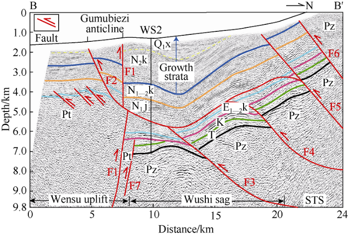
Fig. 4.
Seismic profile B-B′ with geological interpretations (the location is shown in
Fig. 5.

Fig. 5.
Seismic profile C-C′ with geological interpretations (the location is shown in
Fig. 6.
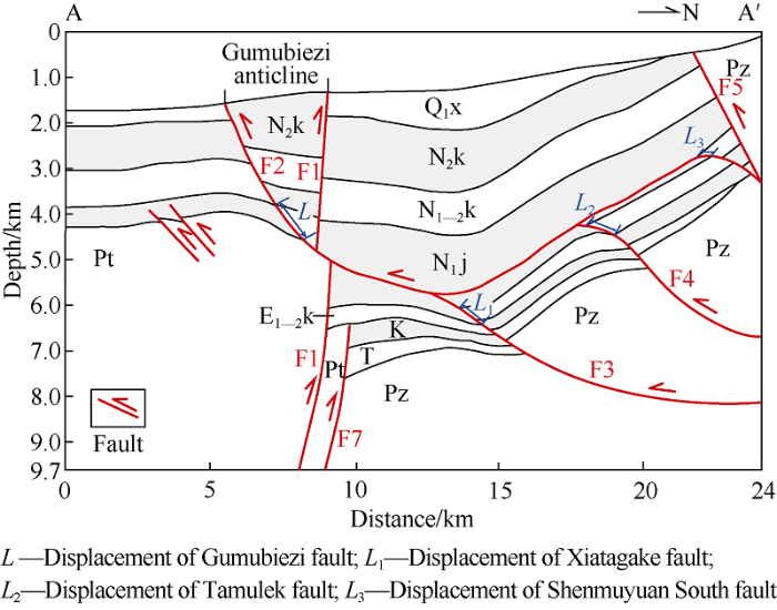
Fig. 6.
Quantitative analysis of displacements of faults in profile A-A′ (see
Fig. 7.
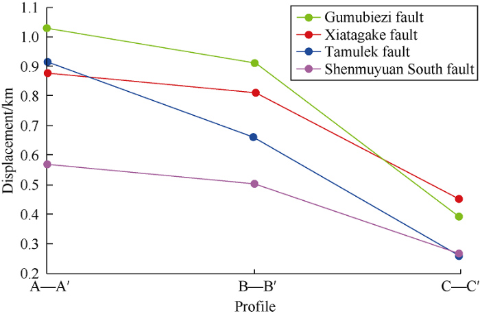
Fig. 7.
Variation trend of displacements of faults in the Gumubiezi structural belt.
2.2. Structural deformation of the west segment of the Gumubiezi structural belt
D-D′, E-E′, and F-F′ are three regional profiles passing through the South Tianshan, Wushi sag, and Wensu uplift in the western segment of the GSB (Figs. 8, 9 and 10). The area can be divided into the following three structural units according to the characteristics of the profiles: (1) South Tianshan thrust system in the Proterozoic controlled by the high-angle basement faults; (2) the thrust system in the north margin of the Wushi west sag; and (3) the GSB (western segment) made up of the high-angle Wensu North fault thrusting northward and small faults in the Wensu uplift.
Fig. 8.

Fig. 8.
Seismic profile D-D′ with geological interpretations (the location is shown in
Fig. 9.

Fig. 9.
Seismic profile E-E′ with geological interpretations (the location is shown in
Fig. 10.
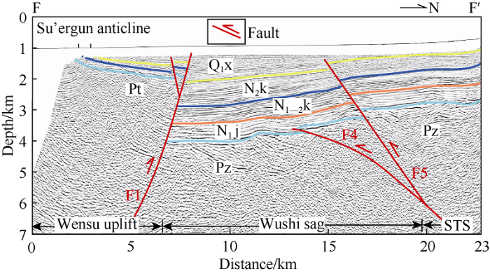
Fig. 10.
Seismic profile F-F′ with geological interpretations (its location is shown in
The southern boundary faults of the South Tianshan thrust system, the Shenmuyuan fault and Shenmuyuan south fault, thrust at large displacement, which caused the Proterozoic to be lifted to the surface (Figs. 8 and 9). There is no duplex structure in the deep part of the Wushi sag, rather it shows as a southward-imbricated thrust. The Shenmuyuan south fault thrust out of the surface, and along with Tamulek fault, causing deformation of the hanging wall. The southern Wensu uplift is composed of the Wensu North fault thrusting northward and its branch faults thrusting southward. The Wensu North fault was active in the Cenozoic after the deposition of the Jidike Formation and began to move strongly in the early Miocene. This resulted in the difference in thickness of the Jidike Formation, its upper strata in the Wensu uplift and Wushi sag on two sides of the fault.
3. Tectonic transformation in Gumubiezi structural belt
The most important feature of the structural transformation of the GSB is that GF decreases gradually in displacement from the east to the west, and then the fault disappears in the west segment of the GSB (Fig. 11). Previous studies have suggested that the development of detachment layers and paleo-uplifts has strong control on the structural deformation of thrust belts[26]. The existence of the detachment layer causes structural deformation to transmit to the interior of the basin on a large scale[27,28,29], and the existence of paleo-uplift beneath the detachment layer can cause large-scale thrust out of surface when the deformation propagates to the location of the paleo-uplift[26, 30-31].
Fig. 11.
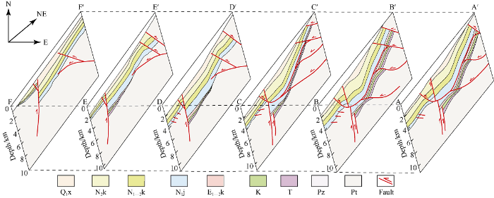
Fig. 11.
3D structure model of the Gumubiezi structural belt.
The thickness of the Jidike Formation in the Gumubiezi structural belt and its surroundings decreases gradually from east to west (Figs. 12 and 13). In the eastern segment, the detachment layer in the Jidike Formation is thicker, while it becomes thinner in the west segment, resulting in weakening of the detachment performance of the Jidike Formation. Due to the strong detachment of the Jidike Formation on the eastern side of the east segment, most of the displacement in the deep thrust zone was converted into the bedding displacement of the roof fault (GF) along the Jidike Formation. In the west profiles, due to the weakening of the detachment of the Jidike Formation, one part of the displacement in the deep thrust zone was converted into a bedding displacement of the roof fault along the Jidike Formation, and the other part of the displacement was absorbed by the deformation of hanging wall of the GF, leading to tilting (deformation) of the upper strata. To the west segment, the Jidike Formation does not have a decollement layer, so the displacement of the deep thrust zone couldn’t be converted into the bedding displacement along Jidike Formation, rather the deep thrust faults caused the deformation of the upper strata on one hand, and expanded upward and broke through the surface on the other hand. Therefore, the thickness change of the Jidike Formation is an important controlling factor, which leads to the spatial variation of the GF.
Fig. 12.
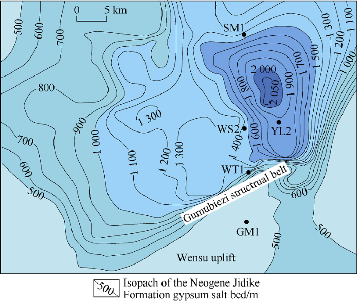
Fig. 12.
Isopach map of Neogene Jidike Formatoin in Gumubiezi structural belt and its surrounding areas.
Fig. 13.
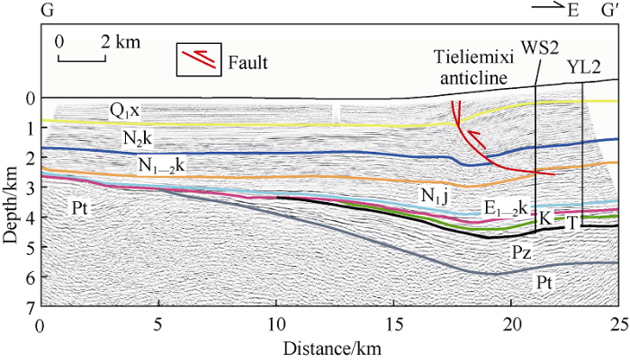
Fig. 13.
Seismic profile G-G′ with geological interpretations (the location is shown in
The displacement of the GF decreases gradually from the east to west of the east segment, and disappears completely in the west segment. How did the east segment transform to the west segment? On the EW seismic crossline, on the west side of Well WS2, there is a westward small-scale thrust fault and an anticline in its hanging wall (Figs. 13 and 14). It is found through analysis that the small thrust fault is a SN lateral ramp of the GF. The lateral ramp is formed by tearing of the tectonic-stratigraphic unit between detachment layers. The east segment of the GSB in the study area has a gypsum mudstone decollement layer, while the west segment has no gypsum mudstone decollement layer in Jidike Formation, causing different shortening of the two segments (6.04 km in the east segment and 3.16 km in the west segment). The difference in shortening in turn resulted in tearing of the strata and formation of the lateral ramp. The combination of a lateral ramp and anticline is called lateral-ramp related anticline[32]. The formation of the Tieliemixi anticline may be related to the oblique crossing of the tear faulting and the direction of compressive stress.
Fig. 14.
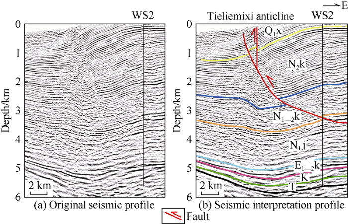
Fig. 14.
Structure interpretation of the lateral ramp (the location is shown in
4. Tectonic evolution of the Wushi segment in the Late Cenozoic Period
The Wushi segment is located in the piedmont of the South Tianshan, and the seismic reflection data of this area is high in resolution, providing good records to tell the time of deformation in the study area. The timing of structural deformation is directly related to the stages of tectonic evolution, and the growth strata, as syntectonic sediments in the piedmont region, are widely used to define the timing of deformation in the fold-thrust-belt[33]. The Kangcun Formation above the duplex structure in the east of Wushi sag is almost constant in thickness, indicating that it is a pregrowth stratum. In contrast, the Kuqa Formation and Xiyu Formation there get thinner toward north and get thicker toward south, indicating they are growth strata, so the bottom boundary of the growth strata is at the bottom of the Kuqa Formation (Figs. 3 and 5). The duplex structure started active during the sedimentation of Kuqa Formation. Similarly, based on the characteristics of the anticline in the hanging wall of the GF, we inferred that the GF started slip along the Jidike Formation (gypsum bed) and broke out of the surface in the early Quaternary.
Taking the eastern part of the Wushi segment as an example, combined with the timing of deformation of the South Tianshan thrust system, the late Cenozoic tectonic evolution of the Wushi segment is divided into two stages (Fig. 15):
Fig. 15.
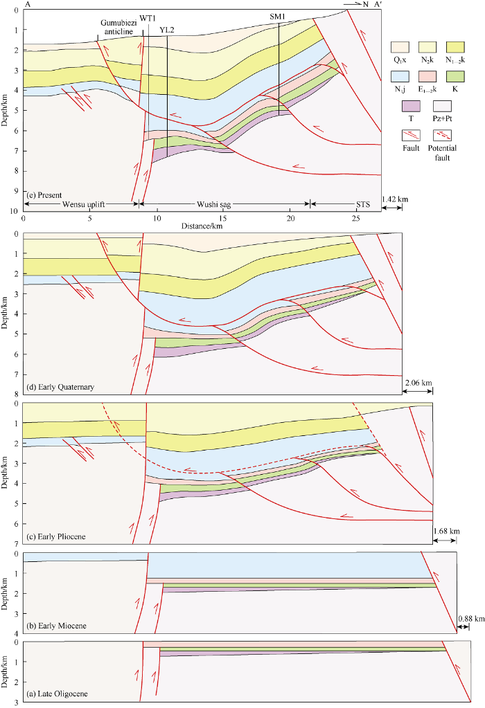
Fig. 15.
The diagram of tectonic evolution of the Wushi segment in the Cenozoic.
(1) Early Miocene (during the deposition of the Neogene Jidike Formation). In the early depositional stage of the Jidike Formation, the South Tianshan thrust system had thrusted, and the fault on the northern margin of the Wensu uplift began to move, which resulted in the significant uplift of the Wensu uplift again. At this time, the GF has not come up yet (Fig. 15b).
(2) Early Pliocene (during the deposition of the Neogene Kuqa Formation). In the Early Pliocene, influenced by the southward thrust of the South Tianshan, the Shenmuyuan south fault, Tamlek fault and Xiatagake fault in the GSB and its surrounding areas started to move, which led to the formation of the duplex structure in the deep part of the Wushi sag (Fig. 15c). The front thrust fault (GF), as a roof fault of the duplex structure, began to slide along the ductile decollement (gypsum bed) at the Early Quaternary. However, due to the blocking of the Wensu uplift, it couldn’t slide further south, and the Gumubiezi anticline was formed in its hanging wall, and the GF cut through the Wensu North Fault and broke out of the surface in the late stage (Fig. 15d). Finally, the Gumubiezi anticline was eroded, forming the current structural geomorphology (Fig. 15e).
5. Conclusions
The Wushi segment in the flank of the South Tianshan fold-thrust-belt can be divided into three units from north to south: (1) The South Tianshan thrust system in the Paleozoic and Proterozoic controlled by high angle basement-involved faults. (2) The Wushi sag and the duplex structure in its deep part consisting of Paleozoic-Mesozoic thrusts, and the roof fault of the duplex structure is the Gumubiezi fault sliding along the Jidike Formation. (3) The Gumubiezi structural belt consisting of the northward Wensu North Fault, the Gumubiezi Fault and the Gumubiezi anticline.
As the GF slipped along the Neogene gypsum-bearing mudstone layer in the Jidike Formation, a part of its displacement was converted into the forward thrust, and the other part was absorbed by the Gumubiezi anticline. The displacement of the GF decreases gradually from 1.21 km in the east A-A′ profile, to 0.39 km in the west C-C′ profile, and completely disappears in the most western D-D′ profile (the western part of the Gumubiezi anticline).
The formation of the GF is related to the gypsum-bearing mudstone layer in the Jidike Formation and the blocking of the Wensu uplift. The differential deformation of the GF from east to west is controlled by differences in the development degree of the gypsum-bearing mudstone layer in the Jidike Formation. In the east of the east segment, the gypsum-bearing mudstone layer in the Jidike Formation is thick and the deformation of the duplex structure in the north of the profile transferred to the basin along the gypsum-bearing mudstone layer. To the west of the east segment, the transfer of the deformation of the duplex to the basin via the gypsum-bearing mudstone layer gradually decreases. In the west segment, the gypsum-bearing mudstone doesn’t occur, the deformation of the deep duplex structure cannot be transferred along the Jidike Formation into the basin, the deep thrust fault broke out of the surface, and the GF disappeared completely. The displacement of the GF to the west eventually disappeared, and the lateral ramp acts as the transitional fault between the east and west segments of the GSB.
Reference
Paleozoic accretion and Cenozoic redeformation of the Chinese Tien Shan Range, central Asia
Paleozoic collisional tectonics and magmatism of the Chinese Tien Shan, central Asia
Cenozoic tectonics of Asia: Effects of a continental collision: Features of recent continental tectonics in Asia can be interpreted as results of the India-Eurasia collision
DOI:10.1126/science.189.4201.419 URL PMID:17781869 [Cited within: 1]
Active faulting and Cenozoic tectonic of the Tien Shan, Mongolia, and Baykal regions
Active thrusting and folding along the northern Tien Shan and late Cenozoic rotation of the Tarim relative to Dzungaria and Kazakhstan
Quaternary folding of the eastern Tian Shan, northwest China
Irregular earthquake cycle along the southern Tianshan front, Aksu area, China
Late Cenozoic tectonic evolution of the southern Chinese Tian Shan
Discussion about the tectonic styles and the cause of formation of the structures in the precordillera thrust belt of Southern Tianshan Mountian
Salt-related structural styles of Kuqa foreland fold belt, northern Tarim Basin
Lateral structural variations and drainage response along the Misikantage anticline in the western Kuqa fold-and-thrust belt, southern Tianshan, NW China
Effect of basement structure and salt tectonics on deformation styles along strike: An example from the Kuqa fold-thrust belt, West China
Features of fault structure in southern margin of west segment of the south Tian Shan, and its control to evolution of the Wushi Sag
Structural pattern and its control on hydrocarbon accumulations in Wushi Sag, Kuche Depression, Tarim Basin
Structural analysis and hydrocarbon formation history of Wushi-Wensu Area in the mid-south TianShan foreland thrust belt
Oil and gas exploration prospect in Wushi Sag and Wensu uplift of Tarim Basin
The tectonic segmentation and hydrocarbon exploration of the foreland thrust belt in the northwestern Tarim Basin
Structural features of Late Paleozoic paleo-uplift and its controls on large natural gas accumulation in Wensu-Luntai Area, Tarim Basin
Early Cambrian syndepositional structure of the northern Tarim Basin and a discussion of Cambrian subsalt and deep exploration
Oil exploration breakthrough in the Wensu salient, northwest Tarim Basin and its implications
The Quele Area of the Kuqa Depression, Tarim Basin, NW China: Cenozoic salt structures, evolution and controlling factors
Cenozoic deformation characteristics and controlling factors of Kalayuergun Structural Belt, Kuqa fold and thrust belt, Southern Tianshan
Geochronological research on the late Cenozoic fault activity in northern Tarim
Tectono-thermal evolution of the northwestern edge of the Tarim Basin in China: Constraints from apatite (U-Th)/He thermochronology
Cenozoic paleo- environmental evolution of the Pamir-Tien Shan convergence zone
The effect of foreland paleo-uplift on deformation mechanism in the Wupoer fold-and-thrust belt, NE Pamir: Constraints from analogue modelling
Development of the Himalayan frontal thrust zone: Salt range, Pakistan
Decollement tectonics in the Jura foreland fold-and-thrust belt
Impact of an interbedded viscous décollement on the structural and kinematic coupling in fold-and-thrust belts: Insights from analogue modeling
The effects of basement ramps on deformation of the Prebetics(Spain): A combined field and analogue modelling study
The effect of basement step/topography on the geometry of the Zagros fold and thrust belt (SW Iran): An analog modeling approach
Eastern Qiulitag displacement transfer structure and its evolution in the Kuqa fold-thrust belt, Tarim Basin: Discuss concurrently the trap-forming of lateral ramp-related anticline
Rates of folding and faulting determined from growth strata: MCCLAY K R. Thrust tectonics
