


Introduction
Faults are widely developed in nature, and complex and diverse in formation mechanisms[1,2,3]. They are closely related to tectonic evolution of the earth, seismic mechanism, distribution of oil and gas and minerals, etc[1,2,3,4,5,6,7], and are the hotspot and difficulty of earth science and engineering application research. In petroliferous basins, fault not only acts as important channel for oil and gas migration, but also has strong control on the reservoir permeability and distribution of oil and gas[4,5,6,7,8,9,10]. In the rift basin, fault zone is conducive to the development of structural traps and hydrocarbon accumulation, so in the same oil source area, different oil-bearing strata and traps of different types may superimpose vertically and transversely, forming composite hydrocarbon accumulation zone[11,12], which is controlled by the secondary structural belt. The theory of composite hydrocarbon accumulation zone has been widely used in rift basins and developed in superim-posed basins in central and western China[13,14,15,16,17]. Previous studies showed that the complex oil-gas accumulation zones in central and western China were mostly formed in superimposed basins with multi-cycle tectonic-sedimentary evolution, multiple sets of source rocks and multi-stages of oil-gas filling and adjustment, various types of reservoirs and accumulation assemblages. In these composite oil and gas accumulation zones, oil and gas are not completely controlled by secondary structural belt[18,19,20,21], and are widely distributed along the paleouplift slope[20,21,22,23,24,25,26,27,28]. Many results have been achieved on the research of composite oil and gas accumulation regularity, but the difference of composite oil and gas accumulation zones controlled by fault needs to be further studied.
The Tazhong uplift located in the middle of the Tarim basinTarim Basin is a typical inherited paleouplift[29] that has undergone multi-cycle tectonic-sedimentary evolution, and an important composite oil-gas enrichment zone[15]. The Tazhong uplift is rich in oil and gas resources. In over 30 years of exploration, industrial oil and gas flows have been tapped in Cambrian, Ordovician, Silurian and Carboniferous; the largest marine carbonate condensate gas field in China, Tazhong I gas field, has been built, where an oil-rich area of over 2 000 km2 has been found along the north slope of the central uplift. The previous study revealed the characteristics of oil and gas distribution of "paleouplift controlling oil and oil enrichment in slope"[20, 23-26, 29-32]. Recent studies show that the oil and gas distribution in the Tazhong uplift is closely related to the fault zone[33,34,35,36]. However, the fluids in different layers and sections of the fault zone come in different phases, adding complexity to the oil and gas production. Therefore, figuring out the difference of oil and gas accumulation in different layers and section of the fault zone is vital for oil and gas evaluation and development.
During previous drilling practice and research, several sets of oil-gas bearing strata have been discovered, but due to limited data, the research is generally in the stage of phenomenon characterization and feature description. In this study, the Tazhong uplift with multiple oil-gas bearing layers in craton basin fault zone is taken as an example, based on fracture structure analysis, by deepening the research of oil and gas traps, reservoir, fluid dynamic and production, we try to find out the composite accumulation mechanisms controlled by faults, the main factors affecting different accumulation of oil and gas in the fault zone, and oil and gas enrichment regularity in fault zone, in the hope to provide theory basis for evaluation and development of similar oil and gas zones.
1. Geological setting
1.1. Regional geology
The Tazhong uplift is located in the middle of the Tarim Basin (Fig. 1). It is a large uplift in north-west-west strike wide in the west and narrow in the east[29], and is divided into several structural belt units, including the central Tarim main horst zone, northern slope zone, and southern slope zone, with an area of about 2.2 × 10⁴ km2. The Phanerozoic strata in the Tazhong uplift are quite complete, in which the Cambrian-Ordovician carbonate rock strata more than 2 000 m thick form a large complex anticline; the Silurian and its overlying formations appear as a gentle and wide large slope with multiple unconformities[20,29]. Taking shape in the Middle and Late Caledonian (Ordovician), and finalized in shape in the Early Hercynian (Devonian)[20], Tazhong uplift is a stable uplift with long-term inherited development[20,29].
Fig. 1.
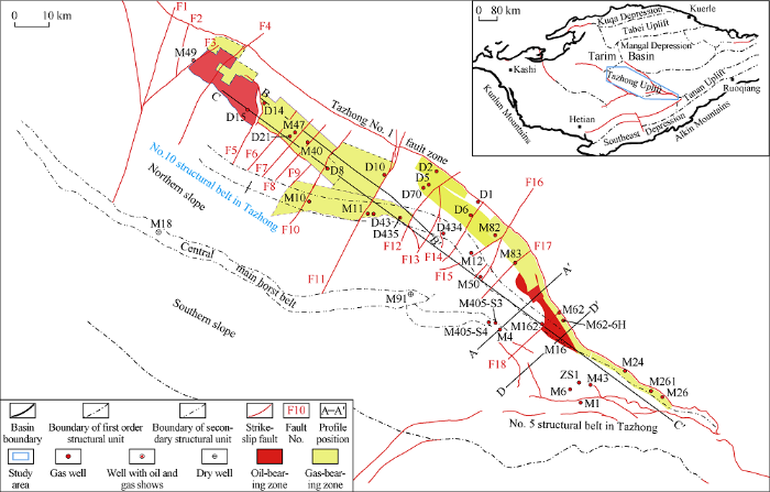
Fig. 1.
Division of structural belts and hydrocarbon distribution in Tazhong uplift of the Tarim Basin.
The Cambrian thick-slope facies marl and lagoon facies mudstone are the main source rocks in the Tarim Basin. Tazhong uplift has very good kitchen oil and gas supply and filling in conditions[15, 20, 25, 30-32], making it the key area for oil and gas exploration and development. During the formation and evolution of the Tazhong uplift, platform margin reef-shoal complexes, insider unconformities, and deep dolomite carbonate architectures, as well as Silurian, Devonian-Carbonaceous sandstone reservoirs were formed, constituting good reservoir-cap combinations with overlying strata. Besides, multiple phases of tectonic movements resulted in multiple types of traps, including structural, stratigraphic, and lithological ones. So far, 33 oil and gas fields have been discovered, with 3P oil reserves of 5.2 × 10⁸ t and 3P natural gas reserves of 8 100 × 108 m3. The Tazhong belt is rich in both oil and gas, and has heavy oil, conventional oil, condensate oil, condensate gas, and dry gas reservoirs. The oil and gas is mainly distributed in the northern slope of Tazhong uplift, and vertically in the Ordovician, Devonian-Carboniferous, Silurian and Cambrian (Fig. 2). At present, oil and gas exploration is extending to deep formations, with the exploration depth exceeding 7 000 m, and new discoveries have been made in the northern sag. The Silurian-Carboniferous clastic reservoirs have entered the late stage of development, while Ordovician carbonate reservoirs are the key development domain. Evaluation and development of carbonate oil and gas reservoirs reveals that the oil and gas distribution is complex in these reservoirs, and the "large quasi-layered" oil and gas reservoir model[15,30-31] in the clastic reservoir evaluation and exploration stage can’t effectively guide development deployment in carbonate reservoir.
Fig. 2.
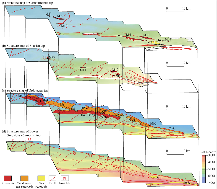
Fig. 2.
Structure and oil and gas distribution of main target layers in the northern slope of the Tazhong uplift.
1.2. Fractures
There are Tazhong I structural belt, Tazhong 10 structural belt, central main horst belt, and Tazhong 5 structural belt etc thrust structural belts from north to south in Tazhong uplift (Fig. 1). These thrust structural belts, spreading in the west, converging in the east, appear like a broom on the whole, and strike north-north-west mainly. The interpretation of three-dimensional seismic data in recent years shows that a series of north-east strike-slip faults develop in the north-central slope of Tazhong, penetrating the north-west thrust structural belt, forming a structural pattern with separated zones in south- north direction and sections in east-west direction.
1.2.1. Thrust faults
In the east and west segments of the Tazhong I structural belt, there are northward thrusting basement faults with vertical fault throw of more than 1000 m, small secondary faults and local structures, and fault zone is more than 2 km wide. Interpretation of high-precision 3D seismic data acquired in recent years show there is no large-scale fault in the middle section of the Tazhong I structural belt[20, 34-35, 37], the strata gently dip to the north, and there are only local small-scale faults, which cut down to the Cambrian gypsum salt layer, forming caprock slip faults (Fig. 3a), with the vertical fault throw of less than 100 m. The Tazhong I fault was formed in the middle Caledonian (Middle Ordovician) and was basically finalized in shale in the late Caledonian (Late Ordovician)[20].
Fig. 3.

Fig. 3.
Typical seismic profiles of thrust faults (a) and strike-slip faults (b) in the north-central slope of Tazhong (pofile position in
The Tazhong 10 structural belt has a southward thrusting slip-type fault, which runs up to the Ordovician and down to the Cambrian gypsum salt layer (Fig. 3a). The Tazhong 10 structural belt is cut by a northeast strike-slip zone and has obvious segmentation feature. The fault has vertical fault throw of up to 300 m and large lateral variation. Many parts have back-thrust faults thrusting northward, forming fault anticline structural belt. The Tazhong 10 structural belt was formed in the middle Caledonian and experienced inherited development from the late Caledonian to Hercynian (Late Paleozoic)[20].
1.2.2. Strike-slip faults
Interpretation of new 3D seismic data acquired in recent years show there are a large number of north-east strike-slip faults[20, 34-38] (Fig. 3b). Strike-slip faults have obvious features on the seismic profile, and most of them appear as "positive flower-like" or "negative flower-like" structural patterns. Steep and straight in fault plane, they mostly run upwards to the Silurian-Devonian system, and a few to the Permian, and down into the Precambrian basement. They belong to the basement-involved strike-slip faults, and most of them are sinistral slip-tenso ones. These strike-slip faults are smaller in vertical fault throw (mostly 50-150 m), and often accompanied by the development of small "pull-down graben".
The strike-slip fault is divided into feather-shaped fractured section, inclined strike-slip section and linear strike-slip section on the plane[37]. The inclined strike-slip sections mostly have dolphin, ribbon, and braid identification marks, and mainly occur on the north slope of Tazhong. The plume fracture section is near the Tazhong I structural belt, and is the part where the strike-slip faulting stress releases and faulting stops. This section takes on horsetail or feather structure.
The strike-slip fault activity in the Tazhong uplift was mainly concentrated in the Caledonian-Hecynian Period[34,35,36,37]. Some strike-slip faults might start active in the Central Caledonian period, and have been active or more active during the late Caledonian-Early Hercynian period, and active locally in the late Hercynian period. Multiple phases of strike-slip fault activities have laid a very important foundation for oil and gas accumulation in the northern slope of Tazhong.
2. Geology of oil and gas reservoirs
The latest research shows that the Tazhong uplift is a large-scale oil and gas enrichment area with deep Cambrian mudstone-marl as the main source rock and faults as the main transport framework which has experienced multi-stage accumulation evolution and adjustment. Faults are the key and core of composite oil and gas accumulation. There develop Cambrian-Ordovician marine carbonate, Silurian and Devonian-Carboniferous clastic rock and other oil and gas reservoirs from the bottom up in the Tazhong uplift, which are mainly distributed in the north slope of Tazhong (Table 1). The Carboniferous oil reservoirs are largely conventional ones; the Silurian reservoirs include oil and heavy oil ones; the Carboniferous to Silurian has "oil below gas", showing obvious oil-gas gravity differentiation. Ordovician carbonate reservoirs largely contain condensate gas, have big changes in fluid properties. These reservoirs have abnormal "gas below oil" feature, complex distribution of oil, gas and water, and no obvious phase differentiation. Carboniferous oil and gas is distributed within 1.5 km around the faults. The oil reservoirs are structural ones controlled by fault zone and have the characteristics of high and stable production. In the Silurian, oil and gas is widespread and enriched along fault zones. The reservoirs are mostly lithologic-structural heavy oil reservoirs. The oil and gas enrichment is controlled by faults, lithology, and preservation conditions, and single-well production is low. The Ordovician oil and gas are controlled by the reservoir and wide in distribution range, but the fault zone is richer in oil and gas and controls the distribution of high-efficiency wells.
Table 1 Stratified characteristics of reservoirs in the Tazhong uplift.
| Horizon | Lithology | Trap type | Pore type | Porosity/ % | Permeability/ 10-3 μm2 | Fluid characteristics | Reservoir type | Productivity |
|---|---|---|---|---|---|---|---|---|
| Devonian- Carboniferous | Sandstone and small amount of carbonate | Anticline | Primary | 12 to 20 | 10 to 1 000 | Conventional oil, a small amount of gas | Bottom water block and edge water layered types | High and stable production, high recovery rate |
| Silurian | Sandstone | Lithology, fault anticline | Primary | 8 to 15 | 0.2 to 50.0 | Heavy oil, small amount of conventional oil | Bottom water block and edge water layered types | Low and stable production, low recovery rate |
| Ordovician | Limestone, dolomite | Lithologic, stratigraphic ones | Secondary | 3 to 8 | <2 | Complex | Complex | Large changes and low recovery rate |
2.1. The Devonian-Carboniferous
The Devonian-Carboniferous high-porosity and high-permeability sandstone reservoirs in the Tazhong uplift have large thickness and wide distribution, and are mainly east-west local structural traps. Eight oil and gas reservoirs including M4, M16, and M47 have been found (Fig. 2). Except for the stratum overlapping gas reservoir M6 in the structural high, the rest are all structural reservoirs. M4 oilfield has structural oil and gas reservoirs, Carboniferous carbonate and clastic rock layered oil and gas reservoirs, as well as Donghe sandstone block reservoirs, with cumulative proved oil geological reserves of 7 500×104 t, and geological gas reserves of 166×108 m3. The oil field with reserves abundance of (17-174)×104 t/km2, 52×104 t/km2 on average, is medium-high abundance oil field.
The Donghe sandstone is a Devonian-Carboniferous oil and gas enrichment section in the Tazhong uplift. It is massive thick layered medium-fine quartz sandstone, with a thickness of more than 100 m. It has mainly intergranular pores and intergranular dissolution pores, a porosity of 12% to 20%, permeability of (10-1 000)×10-3 μm2, and good correlation between porosity and permeability, representing medium-high porosity and high-permeability reservoir[39].
The Devonian-Carboniferous system contains primarily conventional oil, followed by condensate oil. The crude oil is good in quality, with low wax content, low sulfur content, low density, and low viscosity.
2.2. The Silurian
The Silurian medium-low porosity sandstone reservoirs in the Tazhong uplift have small thickness and large lateral changes, and tectono-lithologic traps. Five Silurian reservoirs have been discovered (Fig. 2), and they belong to structural, and structural-lithologic reservoirs, and are mainly distributed in the Tazhong 10 structural belt. They have 3P geological reserves of 7 520×104 t in total, and reserve abundance of (15-69)×104 t/km2, 22×104 t/km2 on average, representing medium-low abundance reservoirs.
The Silurian sandstone in the Tazhong uplift is low in compositional maturity and dominated by lithic sandstone. The main types of pores in it are residual primary intergranular pores, dissolved pores, micropores, and microcracks. Residual primary intergranular pores and micropores take majority in most sections. The Silurian oil layers are fine and above in granularity, and largely low-permeability reservoirs with a porosity of 8% to 15% and permeability of (0.2-50.0)×10-3 μm2.
The Silurian in the Tazhong uplift contains mainly heavy oil and a small amount of conventional oil[40], with big differences in the fluid properties. The conventional reservoirs have stable oil production (20-60 t/d), while the heavy oil reservoirs have low and unstable production (less than 20 t/d).
2.3. The Ordovician
The Cambrian-Ordovician carbonate rocks in the Tazhong uplift contain mainly secondary fracture-cave reservoirs, which have strong heterogeneity and lithological traps. The Ordovician carbonate rocks are rich in oil and gas resources, and 20 oil and gas reservoirs have been discovered (Fig. 2). The reservoirs are the Upper Ordovician reef-bank complexes[20, 30] and the middle-lower Ordovician interlayer karst fracture-cave bodies[31-32, 41]. The fluid mainly consists of condensed gas, followed by conventional oil and dry gas. Except for the possible local structural trap in Well Tazhong 1 at the structural high, the rest reservoirs are non-structural oil and gas reservoirs controlled by the physical properties of carbonate rock, with total proven oil geological reserves of 3.7× 10⁸ t and totalgas geological reserves of 7 900×108 m3.
The upper part of the Ordovician (Upper Ordovician) is dominated by limestone, and the lower part (Middle-Lower Ordovician) gradually transitions from limestone to dolomite. At burial depths of 4 000 to 7 500 m, the reservoirs have lost almost all primary pores and have mainly secondary dissolution pores, which are complex secondary storage systems formed by multiple diagenesis and tectonic movements[20, 30-31, 42-44]. The Ordovician Lianglitag Formation in the Tazhong I structural belt has typical platform marginal reef-shoal type reservoir, which is dominated by reef-bank facies granular limestone. With dissolution pores, caves, and fractures etc as storage space, the reservoirs are mostly pore-vug and fracture-pore-vug types. Statistics show the core samples have a porosity range of 1.2% to 8.0% and permeability range of (0.01 to 2.00)×10-3 μm2, representing ultra-low porosity-low porosity, ultra-low permeability-low permeability reservoir[20, 30]. According to the interpretation of log data, the section with developed matrix pores and the section with large fractures and caves have a porosity range of 2% to 6% and more than 10% respectively, this is to say the two types of reservoirs differ widely in physical properties. Some wells encountering large-scale fracture-cavity system had severe mud loss and drill break during drilling. The Middle-Lower Ordovician has interlayer karst fractures and caves, and the favorable reservoirs are mainly distributed within 200 m from the top of the Yingshan Formation. The dissolution of the vertical vadose zone shows in forms of dissolution pores and caves and sinkholes along fractures; while the horizontal phreatic zone has large vugs and caves featuring horizontal elongation in shape[31].
The fluids in the Ordovician carbonate reservoirs of Tazhong uplift are complex in characteristics and distribution[20], including heavy oil, conventional oil, condensate oil, and wet and dry gas, with properties varying greatly between wells. The crude oil generally has the characteristics of low density, low viscosity, low colloidal and asphaltene content, low and medium wax content, and low and medium sulfur content. The natural gas vary widely in composition, with methane content ranging from 80.57% to 92.50%, CO2 content ranging from 0.14% to 3.48%, N2 content ranging from 3.29% to 9.12%, and relative density from 0.61 to 0.68. Although the reefs and beaches in the east of Tazhong mainly contain condensate gas reservoirs, there are some oil wells with gas-oil ratios below 500 m3/m3 and produce oil primarily. Moreover, the gas-oil ratio decreases to the south rapidly, and conventional oil reservoirs come up.
In summary, the Devonian-Carboniferous in the Tazhong uplift has high-porosity and high-permeability reservoirs with abundant primary pores, large thickness, wide vertical and horizontal extension, and good homogeneity. The Silurian contains low-permeability clastic rock reservoirs with large lateral changes in physical properties and thickness. Ordovician carbonate rocks have low-porosity and low-permeability matrix reservoirs and karst fracture-cavity reservoirs with mainly secondary pores, strong heterogeneity, and complex and diverse vertical and horizontal changes. There are multiple types of traps in the Tazhong uplift. The Carboniferous has largely structural traps. The Silurian has structural-lithologic traps, and the Ordovician lithological traps. Multiple types of oil and gas reservoirs have been discovered such as structural, structural-lithological, and lithological reservoirs, which produce heavy oil, conventional oil, condensate, and dry gas etc (Fig. 4).
Fig. 4.

Fig. 4.
Composite accumulation model of oil and gas controlled by fault in the north slope of the Tazhong uplift (pofile position in
3. Differences in hydrocarbon accumulation in fault zones
Drilling results have confirmed that the oil and gas reserves and production of the Tazhong uplift are mainly distributed along the fault zones. As the faults are distributed in different formations vertically and different zones laterally, different fault zones differ widely geological conditions and hydrocarbon distribution.
3.1. Enrichment of oil and gas around the fault zone
The traps in the Silurian-Carbonian clastic rock formations on the northern slope of the Tazhong uplift are mainly distributed on the fault zones, where 93% of oil and gas reserves accumulate. The oil and gas discovered in the Ordovician is mainly concentrated in the fault zones, accounting for 80% and 90% of reserves and production found in the Ordovician.
Except for the M6 oil and gas reservoir which is distributed around the pinchout line at structural high, all the other Devonian-Carboniferous oil and gas fields in the Tazhong uplift are located on the fault zones, mainly distributed along the faults of the Tazhong 10 structural belt and the central main horst belt. Exploration wells more than 1.5 km away from the main faults almost all failed.
The Silurian suffered multiple stages of oil and gas charging and destruction. Therefore, tar sand, heavy oil, conventional oil, and natural gas are distributed in complicated pattern and spread across the northern slope of the Tazhong uplift[15, 40, 45]. The large-scale fault zones with late oil and gas charging and local structures are the main sites for oil and gas accumulation. Among them, the Tazhong 10 structural belt has the richest oil and gas resources, and the oil and gas wells are mainly distributed within 2 km of the fault zone.
Early studies suggested that the Ordovician carbonate oil and gas in the Tazhong uplift was a large quasi-layered oil reservoir controlled by reservoirs[30]. Evaluation and development show that the matrix-pore type reservoirs have low abundance of oil and gas reserves, and can’t reach industrial productivity under current technological conditions. At present, the main targets of drilling are karst fracture-cavity reservoirs related to faults. Most high-efficiency wells with oil and gas production of more than 5×10⁴ t are distributed within 2.5 km from the main fault. Individual high-efficiency wells far from the main fault are controlled by local structural highs.
Compared with clastic rock, oil and gas wells in carbonate formation are farther from the fault, up to 4 km. But the cave-type reservoir encountering rate and drilling success rate within 1.5 km of the fault zone are as high as 67% and 87%, much higher than 33% and 57% more than 1.5 km from the fault. The average cumulative oil and gas production per well in the fault zone is significantly higher, and more than 70% of the high-efficiency wells are located on the large fractured zones.
3.2. Differences in hydrocarbon accumulation in the fault zones
Different from the composite oil and gas enrichment characteristics of petroliferous basins in eastern China, the oil and gas accumulation in the fault zones of the Tazhong uplift in the Tarim Basin has some particularities. Macroscopically, the oil and gas distribution in the Tazhong uplift features “oil above gas", "west oil and east gas", and "south oil and north gas" (Figs. 2 and 4).
3.2.1. Vertical differences
In the Tazhong uplift, oil and gas are characterized by composite accumulation and differential gathering along the fault zones. The Devonian-Carboniferous has mainly conventional oil reservoirs; the Silurian has primarily heavy oil, some conventional oil, and tar sands universally; the Ordovician contains mainly condensate gas, and there are condensate gas reservoirs and volatile oil reservoirs and conventional oil reservoirs, crude oil increases in proportion upwards, showing the characteristics of “oil in upper part and gas in lower part, and heavy oil and dry gas”.
Fluid analysis results show that members 3-4 of Penglaiba Formation and Yingshan Formation at the bottom of Ordovician have basically dry gas reservoirs; members 1-2 of Yingshan Formation have typical condensate gas reservoirs with a gas-oil ratio of 910-3900 m3/m3, 2 180 m3/m3 on average; the gas-oil ratio of the Lianglitage Formation in Zhonggu 434 well area decreases further to generally 83-531 m3/m3, and 306 m3/m3 on average, indicating the reservoir is an oil or condensate gas reservoir.
It is concluded from comprehensive analysis that Devonian-Carboniferous oil and gas accumulation is mainly controlled by the scale of traps in the fault zone, Silurian oil and gas accumulation is controlled by oil source faults and preservation conditions, and Ordovician carbonate oil and gas accumulation is controlled by fault-related karst fracture- cave bodies.
3.2.2. Horizontal difference
The deep major faults cutting through the Cambrian to Ordovician are usually the main oil source faults, which control the migration and accumulation of oil and gas. Secondary faults have certain controlling effect on local structural traps and lithological traps, and also have important impact on the development of carbonate fractures and caves, and lead to the differential distribution of oil and gas along large fault zones. Laterally, the oil and gas on the northern slope of Tazhong uplift mainly gathers along large fault zones, and oil and gas is rarely seen in areas far from faults and lack of large fault zones (Fig. 2).
Drilling results show that the large north-west striking thrust fault has a significant control on the hydrocarbon accumulation in local structural traps. Among them, the Ordovician carbonate rock formations in the Tazhong No. 1 structural zone have condensate gas reservoirs, the Ordovician-Carboniferous in Tazhong 10 structural belt and the east part of the central horst zone have oil and gas in multiple formations. The large north-east trending strike-slip faults play an important constructive role in the development of Ordovician carbonate fracture-cave body and also control carbonate oil and gas accumulation. Condensate gas reservoir transitions to oil reservoir from north to south.
Controlled by the differences in fault type, order, segmentation, and distribution[20,36], the oil and gas accumulation in the Tazhong uplift has large differences laterally, and fluid properties in different intervals have large differences, which is most obvious in the north-east trending strike-slip fault zone. The large strike-slip fault zone can be generally divided into horsetail crushing section, diagonal strike-slip section, and linear strike-slip section[20]. The oil and gas in the strike-slip fault zone shows a gradual decrease in gas-oil ratio, gradual increase in oil density, viscosity, and colloidal and asphaltene. The oil and gas layers show regular changes in physical and chemical properties, reflecting huge differences in different sections of the fault zone and the process of oil and gas filling from north to south.
Comprehensive analysis shows that on the basis of "paleo-uplift oil control", the Tazhong Area has the characteristic of fault-controlled composite enrichment, where fault zones control most reserves and production, and the differences in fault zones lead to differences in oil and gas distribution and fluid properties in different layers, zones and sections.
4. Factors controlling differential hydrocarbon accumulation in the fault zones
4.1. Multi-cycle tectonic sedimentary evolution, the base of differential hydrocarbon accumulation in the fault zones
In Cambrian-Ordovician, the Tazhong uplift in the Tarim Basin was in a weak extensional background in the plate and received multiple cycles of carbonate sediments[20]. The Cambrian-Lower Ordovician is dominated by dolomite, and the Middle-Upper Ordovician is dominated by limestone, forming multiple sets of reservoir-caprock combinations.
At the end of the Early Ordovician, the southern part of the Tarim plate turned into active continental margin[20, 29], and strong intra-plate tectonic activity occurred in the Tazhong uplift, causing strong uplift and erosion there, and consequently, the basic frame of the Tazhong complex anticline took shape. There is a clear angular unconformity between the Upper Ordovician Lianglitag Formation and the Middle- Lower Ordovician Yingshan Formation, which caused the formation of interlayer karst reservoir of the Yingshan Formation across the Tazhong uplift[31]. The Upper Ordovician Lianglitag Formation has shallow water isolated platforms, and thus large-area platform margin reef-shoal reservoirs[30]. Dolomitization, interlayer karstification, and reef-shoal sedimentary facies control the development and distribution of large-scale carbonate nonstructural traps. The Tazhong I structural belt, central horst belt, and Tazhong 10 structural belt have structural traps in local parts. The fracture system plays a constructive role in the development of carbonate reservoirs in Tazhong Area. Near the fault zone, not only fracture-cave reservoirs but also fractures develop, which are conducive to the connection between reservoirs, and many wells have high and stable production. In the Silurian, the Tazhong uplift was in a stable subsidence stage, and the Silurian gradually overlapped on the Ordovician unconformity from west to east and from north to south, forming tidal flat and delta facies sediments of frequently interbedded sand and mudstone under the background of a gentle slope, where large-area thin interbedded lithological traps are likely to occur. At the end of the Silurian period, the Tazhong uplift experienced uplift and successive fault activity, hence the Silurian in the Tazhong 10 structural zone developed local structural traps superimposed on lithological traps. In the Late Devonian, the Tazhong uplift and the surrounding area experienced overall subsidence, and the coastal and shallow marine facies thick Donghe sandstone deposited.
We can see that experiencing multi-cycle tectonic-sedimentary evolution, the Tarim Basin has underdeveloped structural traps in local parts, but developed stratigraphic lithological traps and composite traps. Carbonate and clastic rocks form a variety of favorable reservoir-cap combinations, resulting in differences in traps in different formations of the Tazhong uplift vertically (Fig. 4).
4.2. Multi-stage hydrocarbon charging and accumulation, the keys to differential hydrocarbon accumulation in the fault zones
4.2.1. Differences in hydrocarbon accumulation and evolution
Based on the analysis of hydrocarbon generation history, tectonic evolution history, and hydrocarbon accumulation stages, especially the identification of the Cambrian main source rock[32, 46-47], the Tazhong uplift mainly experienced 3 stages of oil and gas charging in the Late Caledonian and Late Hercynian (Permian) and Himalayan respectively, and 2 stages of oil and gas adjustment at the end of Caledonian- Early Hercynian, Indosinian-Yanshan periods respectively. In other words, the area has a complex history of hydrocarbon accumulation[20, 30-32, 48-49].
In the late Caledonian period, the Upper Ordovician thick mudstone rapidly deposited, and the Cambrian source rock in the eastern Mangar Depression entered the peak of hydrocarbon generation. The large amount of oil and gas generated migrated toward and accumulated in Cambrian dolomite, Middle-Lower Ordovician interlayer karst and Upper Ordovician reef-shoal reservoirs[30,31]. At this time, these three types of reservoirs were buried shallow and rich in pores, forming widely distributed large-scale paleo-reservoirs. With the development of the uplift and the activity of the faults, the uplifting and faulting effect reformed the oil and gas reservoirs simultaneously.
From Late Caledonian (Silurian) to Early Hercynian, the Tazhong uplift suffered extensive uplift and erosion, forming an Ordovician carbonate buried hill, the Silurian caprock was basically destroyed, and the early paleo-reservoirs were almost completely destructed, leaving just widely distributed bitumen-bearing sandstone[40]. In the structural low part with huge thick Upper Ordovician-Silurian mudstone cap, some paleo-reservoirs might be preserved[20, 40].
In the late Hercynian period, the adjustment of paleo-reservoirs and charging of newly-formed oil and gas happened, which is the key period for the formation of crude oil resources in the platform basin. Most of the carbonate reservoirs in the Tazhong uplift have hydrocarbon inclusions of the late Hercynian period with homogenization temperature of 90-130 °C, reflecting some oil and gas supplemented in the Late Hercynian period [20].
The natural gas mainly charged in the Himalayan period, and the inclusions with homogenization temperature of 140-150 °C suggest the oil and gas charging in this period. In the late Himalayan period, affected by Neotectonic movements, the platform basin of Tarim Basin was buried rapidly and deeply. The dispersed oil in ancient oil reservoirs, source rocks, and transport systems in deep formations might crack into gas (at Ro value of greater than 2%), causing strong gas invasion along the fault zone on the northern slope of the Tazhong uplift[20, 30, 49]. Gas invasion and reformation were typical features of this period, resulting in coexistence of oil and gas and the characteristic of "gas in lower part and oil in higher part" (Fig. 5).
Fig. 5.
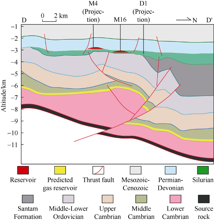
Fig. 5.
Schematic diagram of the fault-controlled composite reservoir in the Tazhong uplift (pofile position in
4.2.2. Differences in hydrocarbon migration and accumulation
The Devonian-Carboniferous system contains mostly conventional reservoirs formed in the Hercynian Period, and the local adjustment faults activated late acted as favorable transport framework for gas invasion, enabling gas to invade into the oil reservoir to form condensate gas reservoir or gas reservoir. The Devonian-Carboniferous oil and gas reservoirs are controlled the vertical shift of faults and the anticline traps controlled by them, and are distributed along the fault-disconnected horizons, in which fluids show obvious gravity differentiation.
From the end of Silurian to the Middle Devonian, Tazhong Area experienced strong uplift and fault activity, and most of the reservoirs were damaged, forming Silurian heavy oil reservoirs and large-area bitumen[40, 45]. Some of the Silurian paleo-reservoirs distributed along the fault zones were replenished with later oil, and had gas invasion locally, improving the quality of the paleo-reservoir. Paleotectonic analysis shows that the Tazhong uplift had maintained a large slope dipping from southeast to northwest during different periods of the Silurian. Oil and gas migrated vertically in local fault development area, but primarily migrated laterally[40, 45]. This kind of near-parallel hydrocarbon migration determines the universal distribution of oil and gas.
In Ordovician, in the northern Tazhong No. 1 structural belt, the conventional reservoir formed in the early stage had strong gas invasion with a large east-south strike-slip fault as the air inlet in the late stage. As gas invasion gradually weakens from west to east, from low to high positions, and from near to far from the gas inlet, resulting in regular changes in the gas-oil ratio, nitrogen, hydrogen sulfide, and other natural gas properties[20]. From the Tazhong No. 1 structural belt to the Tazhong 10 structural belt, from the north to the south, from low to high, the condensate gas reservoir at the platform margin transitions southward to oil reservoir. At the same time, in the fault zone far from the air inlet, as the gas invasion gradually weakens outward, forming the distribution characteristic of "gas in lower part and oil in upper part".
4.3. Fault activity scale and period, the core of differential accumulation of oil and gas in fault zones
The fault system in the Tazhong uplift is very developed, which controls both the structural frame and oil and gas accumulation, and is the main controlling factor of differential oil and gas accumulation. The fact that a series of north-east trending strike-slip faults cut the north-west trending thrust zone is the key for the formation of Devonian-Carbon and Silurian clastic traps, the development of Ordovician carbonate fracture-cave reservoir bodies, and the netlike oil-gas composite accumulation, and controls the vertical migration and lateral adjustment of oil and gas, the formation of primary reservoirs and the distribution of secondary reservoirs.
4.3.1. Faults control favorable direction of oil and gas migration and accumulation
Analysis of drilling data shows that if a trap is connected with fault effectively, the well in the trap will have high and stable production; if a trap isn’t connected with the fault, the drilling in the trap will inevitably fail. Different types and different orders of fault systems form complex three-dimensional transport networks in space, and fault zones are the dominant channels for oil and gas migration. Most oil and gas reservoirs have the characteristic of vertical migration, and the geochemical data shows obvious characteristic of vertical migration[20, 40, 48-49]. The local structural high parts formed by faults are the direction of lateral hydrocarbon migration. More than 95% of the exploration wells in the fault zones of the Tazhong uplift have oil and gas shows or bitumen. Almost all the failed wells are far away from the fault zones, indicating that the fault zones had oil and gas filling universally, and have been the targeted areas for hydrocarbon migration and accumulation.
Well M405-S3 targeting the Carboniferous reservoir in M405 trap north of M4 structure in the Tazhong uplift tested a daily oil production of 160.8 m3 and daily gas production of 3561 m3 without water after gas lift. But Well M405-S4 deployed under the same structural background and trap type did not detect good oil and gas shows in the same interval. The main reason from analysis is that there is no fault connecting the source rock.
The oil and gas in Silurian reservoirs of the Tazhong uplift comes largely from the deep Cambrian source rock[45], so deep major faults connecting oil source are oil source channels for oil and gas accumulation in Silurian reservoirs. Wells drilled in anticline traps close to deep faults such as M47, M11, M12, M50, and M16 etc have all obtained industrial oil flow, while wells far from deep faults such as M45 have water layers from logging interpretation. Deep oil and gas migrate toward and accumulate or adjust and re-gather in Silurian traps through deep major faults, forming structural or structural-lithologic reservoirs.
4.3.2. Faults control the spatial distribution of oil and gas
Controlled by the active stage and scale of fault zone, the clastic rock and carbonate reservoirs in the Tazhong uplift differ widely in oil and gas enrichment characteristics vertically. Wells drilled in reservoirs reached by faults usually have high and stable production, while wells drilled in reservoirs not reached by faults mostly failed. The vertical distribution of oil and gas is closely related to the formations faults reach.
Most faults in the Tazhong I structural belt run up to the Ordovician, so formations above Ordovician produce little oil and gas. Faults in the No. 10 structural belt in the Tazhong uplift break up to the bottom of the Carboniferous, and give rise to the multilayer composite oil and gas system of Carboniferous, Silurian, Upper Ordovician, and Middle-Lower Ordovician[15, 20, 25, 30-31]. Oil source faults are usually large-scale thrust faults and large strike-slip faults. Large oil source faults have obvious control on oil and gas, and they often lead to the formation of large-scale oil and gas accumulation zones. Conductive faults are more developed in the Tazhong uplift carbonate formations, which are usually smaller in scale and make up transport networks in space.
Anatomy of the strike-slip fault zone shows that the Ordovician “from new to old, top to bottom, from shallow to deep” has obvious characteristics of “south oil and north gas, oil in upper part and gas in lower part”; Grade I oil source faults come up in reservoirs from south to north from deep to shallow, oil and gas filling is strong in fault zones on the whole, and the favorable area is broad. Whereas Grade II oil source faults gradually shift to deeper reservoirs from south to north, and have weak oil and gas filling strength. The shallow layers in the south and the deep layers in the north are favorable areas (Fig. 6).
Fig. 6.
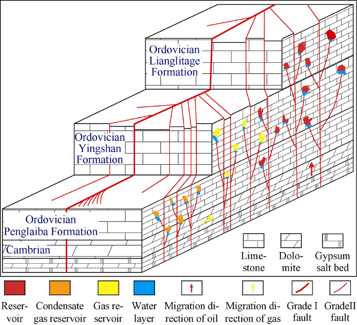
Fig. 6.
Schematic diagram of 3D hydrocarbon accumulation in the strike-slip fault zone of the Tazhong uplift.
4.3.3. Control of faults on different fluid properties
During the formation and evolution of the Tazhong uplift, if the fault system, as the main transport grid, communicated effectively with a trap for a long period of time, allowing multiple times of oil and gas charge into the trap, the trap would have a high degree of filling and be difficult to reach phase equilibrium. If the fault system communicated with multiple traps periodically, allowing charge of oil and gas of different maturities or oil and gas from paleo-reservoir adjustment, the reservoirs would differ widely in filling degree and fluid properties (Table 2)
Table 2 Phase state data of fluids in the fault-controlled composite oil and gas enrichment area of the Tazhong uplift.
| Oil & gas field/fault zone | Horizon | Formation pressure/ MPa | Formation temperature/°C | Saturation pressure/ MPa | Crude oil density/ (g•cm-3) | Gas-oil ratio/ (m3•m-3) | Methane content/ % | Dew point pressure/ MPa | Critical pressure/ MPa | Critical evaporation pressure/MPa | Critical temperature/°C | Critical evaporation temperature/°C | Oil and gas reservoir type |
|---|---|---|---|---|---|---|---|---|---|---|---|---|---|
| Tazhong 4 | Carboniferous | 33.02 | 98.0 | 6.17 | 0.8280 | 200 | 7.78 | 11.35 | 598.1 | 659.7 | Black oil | ||
| Tazhong 16 | 44.18 | 110.1 | 7.07 | 0.7936 | 25 | 3.80 | 7.44 | 454.8 | 456.2 | ||||
| Tazhong 11 | Silurian | 45.43 | 113.1 | 18.55 | 0.7670 | 74 | 7.21 | 20.18 | 487.5 | 491.9 | Black oil | ||
| Tazhong 12 | 50.80 | 115.3 | 3.28 | 0.9555 | 5 | 1.98 | 3.29 | 507.6 | 507.7 | Heavy oil | |||
| Tazhong 62 | Ordovician Lianglitag Formation | 55.64 | 130.2 | 55.64 | 0.8110 | 3 245 | 91.92 | 55.64 | 29.59 | 59.20 | -99.2 | 315.3 | Condensate |
| Tazhong 82 | 63.96 | 137.3 | 61.43 | 0.7972 | 2 316 | 83.09 | 61.43 | 40.12 | 62.71 | -89.8 | 407.2 | ||
| Zhonggu 43 | Ordovician Yingshan Formation | 63.33 | 124.9 | 56.99 | 0.7620 | 1 018 | 79.91 | 56.99 | 48.74 | 58.89 | -37.4 | 346.9 | Condensate |
| Zhonggu 8 | 66.11 | 148.0 | 44.61 | 0.7878 | 951 | 78.81 | 44.61 | 30.24 | 45.61 | -43.2 | 345.6 | ||
| Zhonggu 15 | Ordovician Yijinafang Formation | 69.43 | 133.7 | 33.42 | 0.6001 | 305 | 22.18 | 33.44 | 337.6 | 412.0 | Unsaturated oil |
Analysis of oil and gas production and PVT experimental results show that Carboniferous crude oil samples have a density range of 0.7936 to 0.8280 g/cm3, gas-oil ratio of less than 200 m3/m3, low critical pressure and high critical temperature. In some structures where gas was charged in late stage due to late fault activity, the fluid in the reservoir has lower density and high gas-oil ratio. The Silurian crude oil samples have a density of 0.7670-0.9555 g/cm3, and gas-oil ratio of less than 74 m3/m3. The Tazhong 11 well area connected by late active fault had strong gas filling and is an oil reservoir, whereas the Tazhong 12 well area is a heavy oil reservoir. The Cambrian and Ordovician systems all experienced late gas invasion, so they have mainly condensate gas reservoirs, with complex local phases, showing in the forms of volatile reservoir, oil reservoir, and unsaturated reservoir etc (Table 2).
Drilling results have confirmed that oil and gas reservoirs in the fault-controlled composite oil and gas accumulation zone in the Tazhong uplift often have some complex phenomena such as coexistence of multiple kinds of hydrocarbons, multiple fluid interfaces, or inversion of oil-gas-water positions. In the same oil and gas reservoir, oil varies widely in property in different test intervals or different periods of trial production. For example, Well M62-6H has produced 10.5×10⁴ t of oil and 2.5×10⁸ m3 of gas cumulatively. In the initial production stage, crude oil had a density of 0.799 g/cm3 (20 °C), and gas-oil ratio of 3 500 m3/m3; in the late stage of production, the crude oil had a density of 0.846 g/cm3 (20 °C) and gas-oil ratio of 1 000 m3/m3. In addition, the fluids in different layers of the same reservoir may be different too. For example, the crude oil from the lower production layer of Well M82 has a lower density and higher gas-oil ratio than that from the upper production layer. That means the fluid is in a dynamic non-equilibrium state[18].
Due to the complex multi-phase hydrocarbon accumulation and adjustment and reformation in the fault zone, different layers and parts are different in fluid filling intensity. Especially the difference in late natural gas filling leads to mixed distribution of heavy oil reservoirs, conventional reservoirs, condensate gas reservoirs and gas reservoirs, and great differences of fluid properties between wells.
5. Conclusions
Gas reservoirs, condensate gas reservoirs, volatile oil reservoirs, conventional oil reservoirs and heavy oil reservoirs have been found in the Cambrian-Ordovician carbonate, Silurian and Devonian-Carboniferous clastic rock formations in Tazhong uplift. The oil and gas accumulate along the fault zones in composite pattern on a large scale, and show the distribution pattern of "oil above gas, west oil and east gas, and south oil and north gas".
There develop large east-west thrust faults and north-east strike-slip faults in the Tazhong uplift. The coupling between fault formation evolution and hydrocarbon accumulation stages controls the enrichment degree of oil and gas. The spatial-temporal configuration relationship between faults and traps determines the filling degree and phase equilibrium of oil and gas reservoirs. Fault control results in oil and gas reservoirs with wide differences.
Multi-phases of tectonic sedimentary evolution result in the differences in trap conditions in the fault zones, and the differences in multi-phase hydrocarbon migration and accumulation result in complex and diverse fluid properties. Adhering to fine description of the fault zones and quantitative delineation of reservoir bodies, overall evaluation and three-dimensional development are the keys to ensure scale and efficient development of the fault-controlled composite oil and gas accumulation zone in Tazhong Area.
Reference
San Andreas fault zone head waves near Parkfield, California
DOI:10.1126/science.251.5001.1592
URL
PMID:17793143
[Cited within: 2]

Microearthquake seismograms from the borehole seismic network on the San Andreas fault near Parkfield, California, provide three lines of evidence that first P arrivals are &quot;head&quot; waves refracted along the cross-fault material contrast. First, the travel time difference between these arrivals and secondary phases identified as direct P waves scales linearly with the source-receiver distance. Second, these arrivals have the emergent wave character associated in theory and practice with refracted head waves instead of the sharp first breaks associated with direct P arrivals. Third, the first motion polarities of the emergent arrivals are reversed from those of the direct P waves as predicted by the theory of fault zone head waves for slip on the San Andreas fault. The presence of fault zone head waves in local seismic network data may help account for scatter in earthquake locations and source mechanisms. The fault zone head waves indicate that the velocity contrast across the San Andreas fault near Parkfield is approximately 4 percent. Further studies of these waves may provide a way of assessing changes in the physical state of the fault system.
Fault lubrication during earthquake
DOI:10.1038/nature09838
URL
PMID:21430777
[Cited within: 2]

The determination of rock friction at seismic slip rates (about 1 m s(-1)) is of paramount importance in earthquake mechanics, as fault friction controls the stress drop, the mechanical work and the frictional heat generated during slip. Given the difficulty in determining friction by seismological methods, elucidating constraints are derived from experimental studies. Here we review a large set of published and unpublished experiments (∼300) performed in rotary shear apparatus at slip rates of 0.1-2.6 m s(-1). The experiments indicate a significant decrease in friction (of up to one order of magnitude), which we term fault lubrication, both for cohesive (silicate-built, quartz-built and carbonate-built) rocks and non-cohesive rocks (clay-rich, anhydrite, gypsum and dolomite gouges) typical of crustal seismogenic sources. The available mechanical work and the associated temperature rise in the slipping zone trigger a number of physicochemical processes (gelification, decarbonation and dehydration reactions, melting and so on) whose products are responsible for fault lubrication. The similarity between (1) experimental and natural fault products and (2) mechanical work measures resulting from these laboratory experiments and seismological estimates suggests that it is reasonable to extrapolate experimental data to conditions typical of earthquake nucleation depths (7-15 km). It seems that faults are lubricated during earthquakes, irrespective of the fault rock composition and of the specific weakening mechanism involved.
Finding fault in fault zones
DOI:10.1126/science.1192223 URL PMID:20616257 [Cited within: 2]
Fault zone architecture and permeability structure
A review of recent developments concerning the structure, mechanics and fluid flow properties of fault zones
Fault zone hydrogeology
A review of fault sealing behavior and its evaluation in siliciclastic rocks
Fractures, faults and hydrocarbon entrapment, migration and flow
Structural and petrophysical characterization of mixed conduit/seal fault zones in carbonates: Example from the Castellas fault (SE France)
Discrete fracture network modelling of a hydrocarbon-bearing, oblique-slip fault zone: Inferences on fault-controlled fluid storage and migration properties of carbonate fault damage zones
Geological evolution of petroliferous basins on continental shelf of China
Formation and distribution of complex petroleum accumulation zones in Bohaiwan Basin
Lunnan Lower Uplift: A multiple oil/gas accumulation play in the Tarim Basin, NW China
Basic geology characteristics of Daniudi composite gas field in Ordos Basin
The central Tarim Lower Uplift: A composite hydrocarbon accumulation play in the Tarim Basin, NW China
Structural belt styles and multiple oil and gas reservoirs/fields in petroliferous basins, Northwestern China
Hydrocarbon accumulation characteristics and the formation mechanism of Palaeozoic reservoir in Tazhong area
Unsteady reservoir in Hadson Oilfield, Tarim Basin
Stereoscopic exploration model for multi-cycle superimposed basins in China
Significant progress of continental petroleum geology theory in basins of Central and Western China
Particularity of petroleum exploration on marine carbonate strata in China sedimentary basins
Main progress and problems in research on Ordovician hydrocarbon accumulation in the Tarim Basin
Reservoir types of marine carbonates and their accumulation model in western and central China
Characteristics and controlling factors of the large carbonate petroleum province in the Tarim Basin, NW China
Geological conditions and distributional features of large-scale carbonate reservoirs onshore China
Distribution characteristics of marine carbonate reservoirs and their tectonic controlling factors across the Sichuan superimposed basin
Gas exploration potential of tight carbonate reservoirs: A case study of Ordovician Majiagou Formation in the eastern Yi-Shan slope, Ordos Basin, NW China
Petroleum controlling theory of Lunnan paleohigh and its buried hill pool exploration technology, Tarim Basin
Hydrocarbon accumulation characteristic and exploration on large marine carbonate condensate field in Tazhong Uplift
Plenty of resource evaluation and exploration work in Tazhong Uplift have confirmed its superior accumulation condition and abundant oil-gas resources in marine carbonate rocks, dominantly occurring in the reef-bank body of Upper Ordovician and weathered crust of Lower Ordovician. In this area, large condensate reservoirs' distribution, which is remarkably characterized by multi-superimpositions in vertical and layer-like features in horizon, is mainly controlled by relative cave-fracture systems. Researches from both multi-discipline and combination of static and dynamic analysis show that large condensate reservoirs in Tazhong Uplift, mostly the carbonate reservoirs of marine face, are primarily feed by two suite of carbonate rocks of Cambrian and Ordovician, whose raw oil is obviously of mixed sources feature; comparatively, the gas mainly comes from the highly matured pyrolysis gas of the Middle and Lower Cambrian; moreover, the Ordovician condensate reservoirs developed in the Himalayan period by the intrusion of Cambrian pyrolysis gas on the palaeoreservoirs, which has experienced three periods of accumulation; oil injected during Late Caledonianand-Late Hercynian period, while gas injected during Himalayan period. Hydrocarbons from two sets of source rocks are the material basis of forming large condensate gas fields of Tazhong Ordovician marine carbonate; tectonics and karstification are the dominant factors that form multiple sets of high-quality carbonate reservoirs in Tazhong Ordovician, additionally, mesh-conduct systems of oil and gas constructed by faults, unconformities and fracture-cave development belts are the important guarantee of accumulation mechanism of Tazhong marine carbonate, which displays complex accumulation and mingled source rocks. Interestingly, Ordovician marine carbonate has a potential reserve of I billion bbl hydrocarbon.
Discovery and exploration of Cambrian subsalt dolomite original hydrocarbon reservoir at Zhongshen-1 well in Tarim Basin
Characteristics of high quality Ordovician reservoirs and controlling effects of faults in the Tazhong area, Tarim Basin
The fault system characteristics and its controlling roles on marine carbonate hydrocarbon in the Central uplift, Tarim Basin
Effects of structural segmentation and faulting on carbonate reservoir properties: A case study from the Central Uplift of the Tarim Basin, China
Structural patterns of fault broken zones in carbonate rocks and their influences on petroleum accumulation in Tazhong Paleo-uplift, Tarim Basin, NW China
Paleozoic fault systems of the Tazhong Uplift, Tarim Basin
The geometry and origin of strike-slip faults cutting the Tazhong low rise megaanticline (central uplift, Tarim Basin, China) and their control on hydrocarbon distribution in carbonate reservoirs
Paleozoic reservoir beds and their favorableness in Tazhong Areas of Tarim Basin, Northwest China
DOI:10.1016/j.petrol.2009.05.014 URL [Cited within: 1]
Condition and explorative direction of lithologic reservoir of Silurian in northern slope of Tazhong uplift
Geological conditions and distributional features of large-scale carbonate reservoirs onshore China
Based on well cores and thin section observations of more than 300 wells from major exploration target areas and formations in the Tarim, Sichuan and Ordos Basins, combined with seismic, well logging and testing data, the types and characteristics of carbonate reservoirs as well as the geologic conditions for their extensive development are analyzed systematically, and their distribution features are summarized. All varieties of marine carbonate reservoirs are developed in China, including three types of large-scale effective reservoirs, which are (1) depositional reef-shoal and dolomite reservoirs, (2) epigenetic dissolution-percolation reservoirs and (3) deep burial-hydrothermal altered reservoirs. Besides sedimentary facies, paleoclimate and paleogeomorphy, other factors controlling the development of deep large-scale effective reservoirs include interstratal and intrastratal dissolution-percolation and burial dolomitization which can be impacted by hydrothermal processes. Large effective reservoirs in deep carbonate rocks are distributed along unconformities and hiatuses in sedimentation, while reservoirs of epigenetic dissolution-percolation type extend from paleohigh uplift zones to lower slope reliefs. The reservoirs are widely distributed in stratified planar forms, and are superposed by multi-stage karstification processes vertically and have obvious heterogeneity controls. Burial dolomitization is restricted by primary sedimentary facies, and can form extensive effective reservoirs in deep layers in layered or stratified shapes. Hydrothermal related reservoirs are always distributed along deep, large faults, forming effective reservoirs in the form of a bead string in vertical direction and band-rod horizontally, which are not restricted by burial depth.
Diagenesis and origin of porosity formation of Upper Ordovician carbonate reservoir in northwestern Tazhong condensate field
DOI:10.1016/j.jngse.2016.12.008 URL [Cited within: 1]
Differences between reservoirs in the intra-platform and platform margin reef-shoal complexes of the Upper Ordovician Lianglitag Formation in the Tazhong oil field, NW China, and corresponding exploration strategies
DOI:10.1016/j.marpetgeo.2018.07.013 URL
Paleokarstic water tables and their control on reservoirs in Ordovician Yingshan Formation, Tazhong Area, Tarim Basin, NW China
DOI:10.1016/S1876-3804(18)30090-9 URL [Cited within: 1]
Evidence and controlling factors of hydrocarbon charging in the Late Silurian in the north slope of the Tazhong Uplift, Tarim Basin
Application of sulfur and carbon isotopes to oil-source rock correlation: A case study from the Tazhong area, Tarim Basin, China
DOI:10.1016/j.orggeochem.2015.03.012 URL [Cited within: 1]
Discovery of the Lower Cambrian high-quality source rocks and deep oil and gas exploration potential in the Tarim Basin, China
DOI:10.1306/03141817183 URL [Cited within: 1]
Key factors controlling hydrocarbon accumulations in Ordovician carbonate reservoirs in the Tazhong area, Tarim Basin, western China
DOI:10.1016/j.marpetgeo.2013.03.002
URL
[Cited within: 2]
The Tazhong area, at the center of the Tarim basin, western China, contains abundant hydrocarbon resources, principally in Ordovician carbonate reservoirs. The geological conditions for hydrocarbon accumulation in the area are quite complicated and are characterized by multiple stages of hydrocarbon generation, accumulation, adjustment and alteration. Despite decades of exploration and production in the region, the mechanisms of hydrocarbon accumulation and their controlling factors are still not well established. The geological setting and the distribution characteristics of the reservoir, have been used to investigate the mechanisms of accumulation, to quantitatively describe the main controlling factors, and to predict potential favorable hydrocarbon accumulation zones in Ordovician carbonate rocks of Tazhong. Our results show that the hydrocarbons in the Ordovician reservoirs came from mixed sources including middle-lower Cambrian and middle-upper Ordovician source rocks within the Majiaer Sag. Four stages of accumulation are recognized and hydrocarbons migrated into the Tazhong area along six intersections of NE and NW fault sets, principally from the northeast to the southwest but then, locally, from the northwest to the southeast. The Ordovician carbonate reservoirs are typically lithologically defined and the dynamic force of hydrocarbon accumulation is primarily reflects differential capillary forces. The accumulation and distribution of hydrocarbons was controlled by the petrophysical properties of the reservoir and by hydrocarbon supply/charge energy. The petrophysical properties of the reservoir controlled the hydrocarbon accumulation threshold with the maximum differential capillary pressure force, on average, approximately 13 MPa. The supply or charge energy of the hydrocarbons controls the accumulation distribution range. The daily production of individual wells decreases with increasing distance from the fault intersections and the maximum hydrocarbon migration distance is about 35 km. Reservoir properties and the hydrocarbon supply/charge Energy coupling Index (REI) appear to control hydrocarbon accumulation and distribution. Accumulation does not occur when the value of REI is <= 0.6, but is favored when values are higher. (C) 2013 Elsevier Ltd.
Origin of deep strata gas of Tazhong in Tarim Basin
